Go to top

749 CE Sabbatical Year Quakes

~16-18 January 749 CE

by Jefferson Williams


Gold Coin dated AH 131 in Bet She'an
Near Mint condition gold dinar from A.H. 131 (31 Aug. 748 - 19 Aug. 749 CE) found
in a coin hoard beneath a collapse layer in Bet She'an - Tsafrir and Foerster (1992b)

Introduction & Summary

Sabbatical Year Quakes Summary

Intensity Estimates

Intensity Estimates

Sabbatical Year Quakes
South Araba Quakes

Textual Evidence

Text (with hotlink) Original Language Religion Date of Composition Location Composed Notes
Damage and Chronology Reports from Textual Sources
Byzantine and Syriac Writers - Introduction and Discussion
Byzantine Writers - Paul the Deacon Latin Christian End of the 8th c. CE Lake Como, Italy
Account

Byzantine Writers - Anastasius Bibliothecarius Latin Orthodox (Byzantium) 871-874 CE Rome
Account

Byzantine Writers - Theophanes Greek Orthodox (Byzantium) 810-815 CE Vicinity of Constantinople
Account

Byzantine Writers - Nicephorus Greek Orthodox (Byzantium) Early 9th c. CE Constantinople
Account

Byzantine Writers - Georgius Monachus Greek Christian Last half of 9th c. CE Constantinople
Account

Byzantine Writers - Megas Chronographos Greek Christian mid-9th c. CE ?
Account

Byzantine Writers - Cedrenus Greek Orthodox (Byzantium) late 11th or early 12th century CE Anatolia
Account

Byzantine Writers - Minor Chronicles Greek Christian ? ?
Account

Byzantine Writers - Joannes Zonaras Greek Christian 1st half of 12th c. CE vicinity of Constantinople
Account

Byzantine Writers - Michael Glycas Greek Christian 2nd half of the 12th century CE vicinity of Constantinople
Account

Syriac Writers - Introduction
Syriac Writers - Dionysius of Tell-Mahre Syriac Syriac Orthodox Church first half of the 9th century CE Antioch, Syria
Account

Syriac Writers - Pseudo-Dionysius of Tell-Mahre vs. Dionysius of Tell-Mahre
Account

Syriac Writers - Theophilus of Edessa Syriac Chalcedonian Christian Last Half of the 8th century CE Edessa ?, Baghdad ? see the accounts of Michael the Syrian and Chronicon Ad Annum 1234.
Syriac Writers - Pseudo-Dionysius of Tell-Mahre Syriac Eastern Christian 750-775 CE Zuqnin Monastery
Account

Syriac Writers - Earthquake Sound Travel and Pseudo-Dionysius of Tell-Mahre
Syriac Writers - Elias of Nisibis Syriac and Arabic Church of the East Early 11th c. Nusaybin, Turkey
Account

Syriac Writers - Michael the Syrian Syriac Syriac Orthodox Church late 12th century CE probably at the Mor Bar Sauma Monastery near Tegenkar, Turkey
Account

Syriac Writers - Chronicon Ad Annum 1234 Syriac beginning of the 13th c. CE possibly in Edessa or the Monastery of Mar Bar Sauma near Tegenkar, Turkey
Account

Christian Writers in Arabic - Agapius of Menbij Arabic Melkite 10th century CE Manbij, Northern Syria
Account

Christian Writers in Arabic - al-Muqaffa Arabic Coptic Christian 10th century CE Egypt
Account

Christian Writers in Arabic - al-Makin Arabic Coptic Christian 1262-1268 CE Damascus (parts may have also been written in Cairo)
Account

Christian Writers in Arabic - Chronicon Orientale Arabic Coptic Christian 13th century CE
Account

Greek Writers - Patriarch Nektarios Greek Greek Orthodox Christian 1677 CE Sinai peninsula or Jerusalem
Account

Greek Writers - Tropologion Sin.Gr. ΜΓ 56+5 Greek Greek Orthodox Christian 9th century CE Jerusalem
Account

Judaic Texts - Ra'ash shvi'it (רעש שביעית) Hebrew Judaism Difficult to date
Account

Judaic Texts - 10th-11th century book of prayers found in the Cairo Geniza Hebrew Judaism 10th-11th c.
Account

Samaritan Sources - Abu l’Fath Arabic Samaritan 1355 CE
Account

Samaritan Sources - Chronicle Adler Arabic ? Samaritan
Account

Armenian Sources - Mekhitar d’Airavanq chronicle Armenian Before 1300 CE Medieval monastery of Geghard
Account

Muslim Writers - Introduction
Muslim Writers - al-Masudi Arabic Muslim - Shi’ite mid-10th century CE Egypt ?
Account

Muslim Writers - Description of Syria including Palestine by al-Maqdisi Arabic Muslim ca. 985 CE Jerusalem ?
Account

Muslim Writers - The Best Divisions in the Knowledge of the Regions by al-Maqdisi Arabic Muslim ca. 985 - 990 CE Jerusalem ?
Account

Muslim Writers - Ibn Nazif al-Hamawi Arabic Muslim early 1230's CE Homs, Syria
Account

Muslim Writers - Sibt Ibn al-Jawzi Arabic Hanbali Sunni Muslim - may have had Shi'a tendencies (Keany, 2013:83) 13th c. CE Damascus
Account

Muslim Writers - al-Dhahabi Arabic Muslim Early 14th century CE Damascus
Account

Muslim Writers - Jamal ad Din Ahmad Arabic Muslim 1351 CE Jerusalem ?
Account

Muslim Writers - Ibn Tagri Birdi Arabic Muslim 15th c. CE Cairo
Account

Muslim Writers - as-Suyuti Arabic Sufi Muslim 15th c. CE Cairo
Account

Muslim Writers - Mujir al-Din Arabic Hanbali Sunni Muslim ca. 1495 CE Jerusalem
Account

Muslim Writers - Other Muslim Writers Arabic Muslim
Text (with hotlink) Original Language Religion Date of Composition Location Composed Notes
Damage and Chronology Reports from Textual Sources

Master Chronology Table - Time of Day - All Authors

Date of Composition Author Holy Desert Quake Talking Mule Quake Notes
775 CE Pseudo-Dionysius of Tell-Mahre the night before the Talking Mule Quake mid morning
End of the 8th century Paul the Deacon 10 am not specified Byzantine authors likely specified the time when the Talking Mule Quake struck rather than the Holy Desert Quake
9th century CE Anastasius Bibliothecarius 10 am not specified Byzantine authors likely specified the time when the Talking Mule Quake struck rather than the Holy Desert Quake
810-815 CE Theophanes 10 am not specified Byzantine authors likely specified the time when the Talking Mule Quake struck rather than the Holy Desert Quake
11th century al-Muqaffa night time not reported copied from earlier biography - first person testimony
9-11th century Ra'ash Shvi'it night time not reported dark chaos in Tiberius may refer to a nighttime earthquake
ca. 1495 CE Mujir al-Din ~7 pm not reported first person testimony presented - Holy Desert Quake preceded by foreshocks at ~3 pm and ~6 pm

Master Chronology Table - Dates - All Authors

Date of Composition Author Holy Desert Quake Talking Mule Quake Notes
775 CE Pseudo-Dionysius of Tell-Mahre not reported 2 April 748 - 1 April 749 CE or 1 October 747 - 30 September 748 CE 1059 A.G.
End of the 8th century Paul the Deacon 18 June 746 - 17 June 747 CE 25 March 749 - 31 Aug. 750 CE no corrections applied
End of the 8th century Paul the Deacon 18 June 746 - 17 June 748 CE 18 June 749 - 24 March 752 CE corrections applied
9th century CE Anastasius Bibliothecarius 18 June 746 - 24 March 749 CE 18 June 747 - 24 March 750 CE corrections applied
810-815 CE Theophanes 18 June 746 - 24 March 749 CE 1 January 749 - 24 March 752 CE corrections applied - outliers removed
Early 9th century CE Nicephoros not reported 1 Jan. 749 - 31 Dec. 750 CE no corrections - around the time of the birth of Leo
Mid 9th century CE (estimate) Megas Chronographos 1 Jan. 746 - 31 Dec. 747 CE not reported no corrections - date range solely based on plague
9th - 11th century Judaic Texts 17/18 January 749 CE not reported 23rd Shvat for day and month, Year from coincidence of 23 Shevat with 17/18 January 749 CE. Year also interpreted from text via Gematria and speculation about Sabbatical Year calculations for this period of time.
Early 11th Century Elias of Nisibis not reported 31 August 748 - 19 August 749 A.H. 131 for Talking Mule Quake
Early 14th century CE al-Dhahabi 4 May - 2 June 748 CE not reported Ramadan A.H. 130 for Holy Desert Quake
1351 CE Jamal ad Din Ahmad 11 September 747 - 30 August 748 not reported A.H. 130 for Holy Desert Quake
15th century CE Ibn Tagri Birdi 11 Sept. 747 - 19 Aug. 749 CE not reported A.H. 130 or A.H. 131 for Holy Desert Quake
15th century CE As-Soyuti not reported 11 Sept. 747 - 19 Aug. 749 CE A.H. 130 for Talking Mule Quake, A.H. 131 for Talking Mule Quake Quake

Master Seismic Effects Tables - All Authors

Holy Desert Quake

Location Description Sources Comments
Palestine Earthquake - many died Theophanes, Paul the Deacon, Anastasius Bibliothecarius, Megas Chronographos, Cedrenus, Minor Chronicles
By the Jordan Earthquake, many died Theophanes, Paul the Deacon, Anastasius Bibliothecarius, Megas Chronographos, Cedrenus
All of Syria Earthquake, many died Theophanes, Paul the Deacon, Anastasius Bibliothecarius, Megas Chronographos, Cedrenus could represent conflation with the Talking Mule Quake
Desert outside Jerusalem Churches and Monasteries collapsed Theophanes, Paul the Deacon, Anastasius Bibliothecarius, Megas Chronographos, Cedrenus Megas Chronographos did not supply a location where the churches and monasteries collapsed.
Wilderness of Saba Village Swallowed Cedrenus
Various Places Many Earthquakes Cedrenus Cedrenus is echoing Luke 21:11. Elias of Nisibis in discussing Talking Mule Quake also says this was a year of many earthquakes. See also Master Seismic Effects Table for the Talking Mule Quake and the row for aftershocks.
Unspecified Many homes destroyed by an earthquake Zonaras, al-Muqaffa, al-Makin, Agapius of Menbij Zonaras - many homes and churches were destroyed
al-Muqaffa - 600 cities and villages affected, many houses ruined in all the cities
al-Makin - 100 or 600 cities damaged or destroyed
Agapius of Menbij - many places devastated
Jericho Spring moved Paul the Deacon, Anastasius Bibliothecarius, Michael the Syrian, Chronicon Ad Annum Paul the Deacon and Anastasius Bibliothecarius do not specify a location and associate this movement with Talking Mule Quake. Michael the Syrian locates the spring in Jericho. Chronicon Ad Annum 1234 locates this in Jericho but says the spring stayed put and the nearby river moved 6 miles.
Coastal Palestine Tsunami destroyed many villages on the coast Michael the Syrian, Chronicon Ad Annum 1234, al-Muqaffa, al-Makin, Judaic Texts Some tsunami reports could really be describing the Dead Sea and/or the Sea of Galilee rather than coastal Palestine however al-Muqaffa and al-Makin, reporting from Egypt, said many ships sank which suggests a coastal tsunami. Final conclusion is there probably was a tsunami that struck coastal Palestine and there may have also been destructive seiches in the Dead Sea and/or the Sea of Galilee.
Coastal Palestine Earthquake on the the coast - many places devastated, many died Agapius of Menbij
Moab (N Dead Sea or Sea of Galilee) fortress on shore moved 3 miles by seismic sea wave Michael the Syrian, Chronicon Ad Annum 1234 Michael the Syrian and Chronicon Ad Annum 1234 both refer to a fortress in Moab inhabited by Yemenite Arabs who Michael the Syrian specifically refers to as the Yemenite Taiyayê tribe. Ambraseys (2009) suggests the possibility that this account of the destruction of a fortress in Moab where the Yemenite Taiyayê tribe lived may refer to a possible earthquake in Yemen in 742 CE (see Ambraseys et al, 1994:25-26).
Jerusalem many houses collapsed or destruction al-Dhahabi, Ibn Tagri Birdi, Mujir al-Din
al-Aqsa Mosque in Jerusalem damaged al-Maqdisi, al-Dhahabi, Jamal ad Din Ahmad, Mujir al-Din
Tiberias destroyed Michael the Syrian, Chronicon Ad Annum 1234, Agapius of Menbij, Judaic Texts
Egypt felt only but Damietta suffered damage al-Muqaffa


Talking Mule Quake

Location Description Sources Comments
Syria Earthquake, Destruction, and Death Theophanes, Paul the Deacon, Nicephorus, Anastasius Bibliothecarius, Georgius Monachus, Cedrenus
Syria Some cities destroyed Theophanes, Nicephorus, Georgius Monachus, Cedrenus
Syria Some cities partially destroyed Theophanes, Nicephorus, Georgius Monachus, Cedrenus
Unspecified or Mount Tabor Translational Landslide Theophanes, Paul the Deacon, Nicephorus, Anastasius Bibliothecarius, Georgius Monachus, Cedrenus, Elias of Nisibis, Michael the Syrian, Chronicon Ad Annum 1234 Byzantine Authors do not locate landslide and by implication locate it in Syria. Elias of Nisibis, Michael the Syrian, and Chronicon Ad Annum 1234 locate the landslide on Mount Tabor possibly for literary/theological reasons indicating that they may have mis-located it. If this landslide did occur on Mount Tabor, it would have been a seismic effect of the Holy Desert Quake.
Mesopotamia Earth Fissure and Sand Boils Theophanes, Paul the Deacon, Nicephorus, Anastasius Bibliothecarius, Georgius Monachus, Cedrenus, Glycas Glycas does not mention the sand boils.
PGA of sand boils estimated at 0.2 - 0.5 g according to Fig. 9
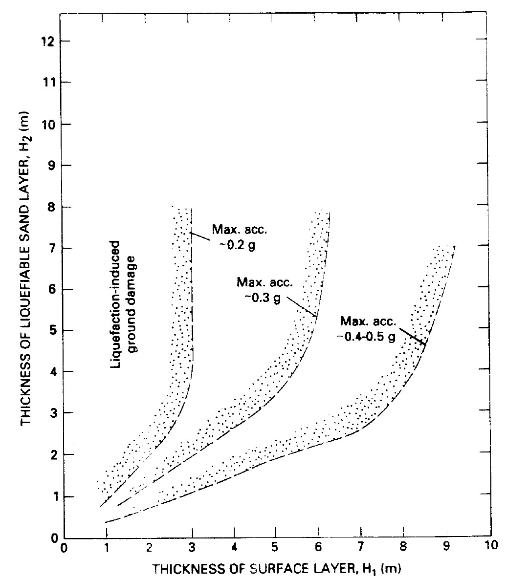
 of Obermeier (1996). PGA = 0.2 - 0.5 g equates to I = 6.7 - 8.2 using transform of Wald et al (1999).
Damascus earthquake with aftershocks for days Michael the Syrian, Chronicon Ad Annum 1234, al-Soyuti al-Soyuti mentions earthquakes experienced in Damascus in A.H. 130 and A.H. 131. In the A.H. 130 earthquake, he mentions damage to the Dajaj suq (poultry market), collapsed buildings and ruins leading to deaths, people being forced to leave town, and a delay of several days in digging the ruins to retrieve victims which implies continuing aftershocks. In the A.H. 131 earthquake, he mentions multiple shocks and damage to a mosque. Abu l’Fath (Samaritan - see Notes), not specifying which quake (but probably Holy Desert Quake), states that Those who survived it stayed out in the open for many days while the earth was still shaking underneath them. Michael the Syrian states that there was an earthquake at Damascus which lasted for days and shook her like leaves on trees. Chronicon Ad Annum 1234 similarly states that there was an earthquake at Damascus and in the whole surrounding area, which lasted for days, and in which the area trembled and was shaken. Elias of Nisibis states that it was a year in which there were many earthquakes. Ibn Tagri Birdi states In that year, there was a strong earthquake in Syria which destroyed Jerusalem. The sons of Shaddad ibn Aws (in Jerusalem ?) died there. The inhabitants were forced to take refuge in the desert, where they stayed for forty days. It is said to have happened in the year 131.
Beit Qubayeh fortress overthrown - deaths Michael the Syrian, Chronicon Ad Annum 1234 This could be a seismic effect for Holy Desert Quake or Talking Mule Quake depending on the fortress' location. Hoyland (2011:270-273) notes that Muslim sources know of a place called the palace (qasr) of Hajjaj, that was just outside Damascus, in view of the Jabiya gate (e.g. Dhahabi. 9.286: Yaqut. `Qasr Hajjaj' ). but this may not be what is meant. Ambraseys (2005:124,footnote 20) states The location of Beit Qoubaya is uncertain. There is a site in northern Lebanon called al-Qubayyat (35.57°N, 36.29°E) (see Dussaud, 1927. 90, 94-95) southwest of Homs. However, damage to Homs, an important urban centre, is not mentioned.
Ghautah and Dareya many died Michael the Syrian, Chronicon Ad Annum 1234
Bosrah and Nawa entirely swallowed up or razed to their foundations Michael the Syrian, Chronicon Ad Annum 1234
Daraat entirely swallowed up Michael the Syrian Sbeinati et al (2005) locate this as the modern Syrian town of Daraa
Ba'albek much of it collapsed, spring "turned to blood" Michael the Syrian, Chronicon Ad Annum 1234
Mabbug destruction everywhere - Church and Walls collapsed Pseudo-Dionysius of Tell-Mahre, Elias of Nisibis, Michael the Syrian, Chronicon Ad Annum 1234 Pseudo-Dionysius of Tell-Mahre and Elias of Nisibis only mention church collapse.
Unspecified Aftershocks Elias of Nisibis a year of many earthquakes
Unspecified Many places ruined Elias of Nisibis

Master Seismic Effects Tables - Byzantine Authors only

Holy Desert Quake

Location Description Sources Comments
Palestine Earthquake - many died Theophanes, Paul the Deacon, Anastasius Bibliothecarius, Megas Chronographos, Cedrenus, Minor Chronicles
By the Jordan Earthquake, many died Theophanes, Paul the Deacon, Anastasius Bibliothecarius, Megas Chronographos, Cedrenus
All of Syria Earthquake, many died Theophanes, Paul the Deacon, Anastasius Bibliothecarius, Megas Chronographos, Cedrenus
Desert outside Jerusalem Churches and Monasteries collapsed Theophanes, Paul the Deacon, Anastasius Bibliothecarius, Megas Chronographos, Cedrenus Megas Chronographos did not supply a location where the churches and monasteries collapsed.
Wilderness of Saba Village Swallowed Cedrenus
Various Places Many Earthquakes Cedrenus Cedrenus is echoing Luke 21:11
Unspecified Many homes destroyed by an earthquake Zonaras


Talking Mule Quake

Location Description Sources Comments
Syria Earthquake, Destruction, and Death Theophanes, Paul the Deacon, Nicephorus, Anastasius Bibliothecarius, Georgius Monachus, Cedrenus
Syria Some cities destroyed Theophanes, Nicephorus, Georgius Monachus, Cedrenus
Syria Some cities partially destroyed Theophanes, Nicephorus, Georgius Monachus, Cedrenus
Unspecified Spring moved ? Paul the Deacon, Anastasius Bibliothecarius
Unspecified Translational Landslide Theophanes, Paul the Deacon, Nicephorus, Anastasius Bibliothecarius, Georgius Monachus, Cedrenus
Mesopotamia Earth Fissure and Sand Boils Theophanes, Paul the Deacon, Nicephorus, Anastasius Bibliothecarius, Georgius Monachus, Cedrenus, Glycas Glycas does not mention the sand boils


Byzantine and Syriac Writers - Introduction and Discussion

Was there one earthquake or two ?

The earliest Byzantine authors report two earthquakes - one which struck in the vicinity of the Jordan Valley and another which struck further north in Syria. The damage reports from all the sources (Byzantine and otherwise) also suggest two earthquakes. The region simply seems seismically incapable of of producing a single earthquake which would create damage over such a wide geographic area (Gaza to Mesopotamia).

Names for the Two Earthquakes - the Holy Desert Quake and the Talking Mule Quake

Due to the chronological confusion present in the various earthquake accounts (Byzantine and otherwise), I am going to refer to the two earthquakes described in the earliest accounts by names rather than dates. The first earthquake described by the Byzantine sources is the Holy Desert Quake. The second is the Talking Mule Quake. The Byzantine accounts are presented in chronological order as shown in the table below. There is a trend where earliest Byzantine accounts mention two earthquakes and later accounts, with the exception of Cedrenus, mention only one. You may notice that Anastasius Bibliothecarius is second before Theophanes even though his date of composition is after Theophanes. This is because textual analysis suggests that he copied his account from an older and more reliable version of Theophanes that we don't have access to. It is effectively an older Theophanes.

Date of Composition Author Holy Desert Quake Talking Mule Quake Notes
End of the 8th century Paul the Deacon yes yes
9th century CE Anastasius Bibliothecarius yes yes Anastasius copied from an earlier version of Theophanes
810-815 CE Theophanes yes yes
Early 9th century CE Nicephorus no yes
9th century CE Georgius Monachus no yes
Mid 9th century CE (estimate) Megas Chronographos yes no
1050's CE Cedrenus yes yes
? Minor Chronicles yes no
12th century CE Zonaras yes no
12th century CE Glycas no1 yes

Chronological Ambiguities and Corrections

The Anno Mundi Calendar, Theophanes, and Indictions

The Anno Mundi Calendar

Several of the Byzantine sources used the Anno Mundi (A.M.) calendar. This calendar is based on the Julian calendar however the year does not begin on 1 January and the starting day, month, and year of this calendar was a point of contention as it was based on an estimate for the start of "creation" (among other things) as interpreted through the Septuagint - a Greek translation of the Old Testament. An ongoing several hundred year long theological debate over when Biblical "creation" began led to multiple versions of the A.M. calendar.

The Alexandrian version of the Anno Mundi Calendar

Earlier Byzantine sources used the Alexandrian version (A.M.a) of the Anno Mundi Calendar. This version of the calendar has a starting date of 25 March 5492 BCE or 25 March 5493 BCE. Grumel (1958:219) explained the two starting dates as follows

The Alexandrian era of Panodorus began in 5493 BCE. The Alexandrian era of Annianos began in 5492 BCE. The Alexandrian Era of Annianos is what is commonly called the Alexandrian era.
I use the Alexandrian era of Annianos which starts in 25 March 5492 BCE as does Guidoboni et al (1994) and Ambraseys (2009).

The Byzantine version of the Anno Mundi Calendar

Megas Chronographos, a later source, used the Byzantine version (A.M.Byz) of the Anno Mundi calendar. This version has a starting date of 1 September 5509 BCE (Bickerman, 1980:73-74).

Calendaric inconsistencies in Theophanes

Historical scholars (e.g. Proudfoot, 1974:373-374, Grumel, 1934:407, and others) have noted that Theophanes A.M.a in the years A.M.a 6102-6206 and A.M.a 6218-6265 are frequently a year too low. One of these problematic A.M.a spans encompasses the years in which the Sabbatical Year earthquakes are reported (A.M.a 6238 and A.M.a 6241).

Indictions

An indiction (Latin: indictio, impost) was a periodic reassessment of taxation in the Roman Empire which took place every fifteen years. In Late Antiquity, this 15-year cycle began to be used to date documents and it continued to be used for this purpose in Medieval Europe. Indictions refer to an individual year in the 15 year cycle; for example, "the fourth indiction" came to mean the fourth year of the current indiction. Since the cycles themselves were not numbered, other information is needed to identify the specific year. When an ancient author supplies an indiction along with an A.M. date, the result may be greater chronological precision. For our dating purposes, indictions began in 312 CE when they were introduced by the Roman Emperor Constantine. The indiction was first used to date documents unrelated to tax collection in the mid-fourth century. By the late fourth century it was being used to date documents throughout the Mediterranean. In 537 CE, Roman Emperor Justinian decreed that all dates must include the indiction. Outside of Egypt, the year of the indiction generally began on 1 September (Bickerman, 1980:78).

Indictions and Grumel's synchronisms MA and MB for Theophanes

Proudfoot (1974:374) noted that the problem of whether Theophanes regarded the year as commencing on March 25 according to the Alexandrian world-year or on September 1 according to the Byzantine indiction cycle has not been resolved with [] clarity. Grumel (1958) thought about this differently and believed that Theophanes occasionally altered the start date for his indictions to match his A.M.a. Grumel (1958) developed two "synchronisms" to explain this.
Grumel's (1934:398-402) synchronisms
Synchronism Explanation
MA Theophanes’s indictions begin in March - the start date for A.M.a
MB Theophanes’s indictions begin in September after the March starting date for A.M.a
Grumel (1958) recommended using MA and MB as shown in the table below.
Grumel's (1934:398-402) synchronisms by time period
Synchronism Years A.M.a (approx.) Date Range CE Historical Markers
MA ? - 6102 ? - 5 Oct. 610 until the end of the reign of Phocas (ruled 23 Nov. 602 – 5 Oct. 610 CE)
MB 6102 - 6206 5 Oct. 610 - 3 June 713 starting with the reign of Heraclius (ruled 5 Oct. 610 – 11 Feb. 641 CE) and ending right before the start of the reign of Anastasios II (aka Artemios) (ruled from 4 June 713 – 4 June 715 CE)
MA 6206 - 6220 4 June 713 CE - 24 March 728 starting with the reign of Anastasios II (aka Artemios) (ruled from 4 June 713 – 4 June 715 CE) until A.M.a 6220
MB 6221 - 6266 1 Sept. 728 - 31 Aug. 774 A.M.a6221 - 6266
MA 6267 - ? 25 March 774 - ? A.M.a6267 - ?
Anastasius Bibliothecarius copied an earlier version of Theophanes

Because Anastasius Bibliothecarius' 'Chronographia Tripartita' is thought to have copied an earlier version of Theophanes' Chronicle, chronological peculiarities in Theophanes are repeated in Anastasius.

The 'Eastern Source'

The three earliest Byzantine sources (Paul the Deacon, Anastasius Bibliothecarius, and Theophanes in that order1) speak of two earthquakes separated by 3 years. The similarity of the ten Byzantine accounts, dates of composition, and the distance of the authors from the region (e.g., writing in Constantinople or Italy) suggests that the accounts are derived from a shared local source(s) and each other. None of the three earliest Byzantine authors could have experienced the earthquakes firsthand. As none of the Byzantine authors cite a source, the shared source - often referred to as the ‘eastern source’ - is a matter of conjecture2. Several scholars (e.g., Brooks, 1906) have suggested that the ‘eastern source’ was cobbled together by a Melkite3 monk who wrote around 780 CE. After civil unrest led to the dissolution of Melkite monasteries in Palestine and Syria, a number of Melkite Monks ended up in Constantinople in 813 CE (Brooks, 1906:587). One of the monks may have brought this text with him – a text that would eventually find its way into the hands of Theophanes. How this source was cobbled together is also a matter of conjecture. Two authors whose works are now lost have been proposed as promising candidates in providing source material - John son of Samuel of whom nothing is known beyond that he lived in Western Syria and Theophilus of Edessa. Theophilus, who wrote in Greek, Syriac, and Arabic, was in his 50’s and living in the region when the earthquakes struck4. John’s Chronicle is thought to have ended in 746 CE (supposedly5) and the unknown editor of ~780 CE may have been a continuator – meaning he added his own version of events from ~746 to ~780 CE. He may have also incorporated Theophilus’ text, simply used Theophilus alone, or used other texts and information. Further, he may have been a redactor meaning that he modified John and/or Theophilus’ original text in addition to adding his own events. Some hypothetical possibilities are shown in Fig. 2. However this ‘eastern source’ came to be, since the Byzantine accounts write about earthquakes which affected Palestine, Syria, and Jazira (northern Mesopotamia), it would appear that the original report(s) of these earthquakes came from these territories.

Footnotes

1 Although Anastasius Bibliothecarius wrote after Theophanes, Neil (1998:46) points out that Anastasius likely based his account on an earlier non-extant and perhaps ‘unfinished’ version of Theophanes thus making his account effectively older than the extant copies of Theophanes we currently have access to.

2 Brooks (1906:587) was one of the first scholars to hypothesize about who wrote the ‘eastern source’. Subsequent work on the subject is discussed in multiple publications including but not limited to Proudfoot (1974), Mango and Scott (1997: lxxxii – lxxxiv), Conrad (1992, 2004), Hoyland, (2011:10), and Conterno (2014).

3 Melkites were supporters of the Council of Chalcedon (i.e., Chalcedonians) who resided in Egypt, Palestine, and Syria. In the church schisms of the time, Chalcedonians were allied with the same faction as Byzantine writers such as Theophanes and wrote in Greek and Syriac thus producing texts which could have been read by the Greek reading Byzantine authors.

4 Theophilus’ Lost Chronicle is known to have directly informed Arabic writer Agapius of Menbig and indirectly informed later Syriac authors such as Michael the Syrian and Chronicon Ad Annum 1234 (Hoyland, 2011:11-15). All three of these authors wrote about the Sabbatical Year Quakes.

5 The dates of the Sabbatical Year Earthquakes may suggest that it ended in 749 CE.

Hypothetical dependencies for Theophanes' eastern source
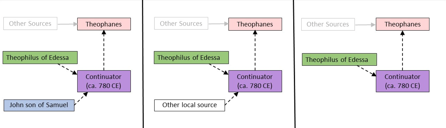
Figure 2 - Three hypothetical source dependencies for Theophanes. Dashed arrows indicate uncertain textual transmission. Solid lines are certain. Other Sources refers to some of the many sources thought to have informed Theophanes Chronicle. Mango and Scott (1997: lxxiv-lxxxviii), for example, list 20 possible sources for different time periods and subjects. Other local source refers to unknown sources of information for the Continuator. Alternative source dependencies are also possible. - Williams (in press)


The Seleucid Era calendar used by the Syriac writing authors and how this may have impacted the Byzantine authors

Background

Tsafrir and Foerster (1992b) and Karcz (2004) both discussed the possibility that the 'eastern source' thought to have been used by Theophanes might have used a Seleucid Era Calendar which used Babylonian reckoning instead of Macedonian reckoning and this may have led to a calendar error if Theophanes converted Seleucid Era dates to A.M.a dates using Macedonian reckoning. Both Tsafrir and Foerster (1992b) and Karcz (2004) noted that such an explanation did not solve the calendaric conundrum present in the dating of the Sabbatical Year Earthquakes. In fact, it is unlikely that Theophanes' "eastern source" would have used Babylonian reckoning as this was not a standard practice for the time (Sebastian Brock, personal communication 2021)

The Seleucid Era calendar used by the Syriac sources

The Seleucid Era calendar, also known as the A.G. calendar, is the calendar that was was used by several of the Syriac writing sources. This calendar has two different starting dates. In what is known as the Macedonian reckoning, the A.G. calendar starts in the Autumn 312 BCE with a starting date that eventually got fixed to 1 October 312 BCE. In the Babylonian reckoning, the starting date of the calendar is 2 April 311 BCE. The Syriac writing authors would have likely used the Macedonian reckoning as this was the standard usage among these authors for the Seleucid era (Sebastian Brock, personal communication, 2021).

Byzantine Writers - Historia Romana by Paul the Deacon

Byzantine Writers - Chronographia Tripartita by Anastasius Bibliothecarius

Byzantine Writers - Chronicle of Theophanes

Byzantine Writers - Chronography (aka Chronographikon Syntomon) by Nicephoros

Byzantine Writers - Chronicle by Georgius Monachus

Byzantine Writers - Megas Chronographos

Byzantine Writers - Synopsis Historion by Cedrenus (aka George Kedrenus)

Byzantine Writers - Minor Chronicles

Byzantine Writers - Epitome of Histories (aka Annales) Book XV by Joannes Zonaras

Byzantine Writers - Biblios Chronike (aka Annals) by Michael Glycas

Syriac Writers - Introduction

The earliest writers in Syriac (Pseudo-Dionysius of Tell Mahre and Elias of Nisbis) appear to give reports of seismic effects from the Talking Mule Quake while the later writers Michael the Syrian and Chronicon Ad 1234 amalgamated several earthquakes into one including unrelated earthquakes in Anatolia and possibly Yemen. Despite this, the later writers provide a rich, albeit likely exaggerated, description of seismic effects. The challenge with the later writers, however, lies in sorting through which earthquakes they were describing in their dramatic narratives. The Reconstructed Lost Chronicle Of Theophilus of Edessa from Hoyland (2011) is helpful in this regard. As with the Byzantine sources, the accounts are presented in chronological order according to date of composition.

Syriac Writers - Annals by Dionysius of Tell-Mahre (aka Denys of Tell-Mahre)

Syriac Writers - Pseudo-Dionysius of Tell-Mahre vs. Dionysius of Tell-Mahre

Syriac Writers - Reconstructed Lost Chronicle Of Theophilus of Edessa

Syriac Writers - Chronicle of Zuqnin (aka Annals Part IV) by Pseudo-Dionysius of Tell-Mahre

Syriac Writers - Earthquake Sound Travel and Pseudo-Dionysius of Tell-Mahre

Syriac Writers - Chronography by Elias of Nisibis (aka Elijah Bar Shinajah)

Syriac Writers - Chronicle by Michael the Syrian

Syriac Writers - Chronicon Ad Annum 1234

Christian Writers in Arabic - Book of History (Kitab al-‘Unvan) by Agapius of Menbij

Christian Writers in Arabic - History of the Patriarchs of Alexandria by Sawirus (Severus) ibn-al Muqaffa

Christian Writers in Arabic - The blessed collection (al-Majmu` al-Mubarak) by al-Makin

Christian Writers in Arabic - Chronicon Orientale

Greek Writers - Epitome by Patriarch Nektarios

Greek Writers - Tropologion Sin.Gr. ΜΓ 56+5

Judaic Texts - Ra'ash shvi'it (רעש שביעית)

Judaic Texts - 10th-11th century book of prayers found in the Cairo Geniza

Samaritan Sources - Kitab al-Ta'rikh (aka Annals) by Abu l’Fath

Samaritan Sources - Chronicle Adler

Armenian Sources - Mekhitar d’Airavanq chronicle

Muslim Writers - Introduction

Chronology

All the Muslim writers who supply a year wrote late - from the 13th to 15th centuries. Among the muslim writers who supply a year, A.H. 130 (11 Sept. 747 - 30 Aug. 748 CE) and A.H. 131 (31 Aug. 748 - 19 Aug. 749 CE) are the years they supply except for al-Mansouri who supplied a year of A.H. 132 (20 Aug. 749 - 8 Aug. 750 CE). The table below lists the years reported (except for al-Mansouri) accompanied by a brief description of where they reported damage:

Date of Composition Author A.H. 130 A.H. 131 Notes
13th c. Sibt ibn al-Jawzi Can't currently access excerpt
Early 14th c. al-Dhahabi Jerusalem and Syria al-Dhahabi provided a date of Ramadan A.H. 130 (4 May - 2 June 748 CE)
1351 CE Jamal ad-Din Ahmad Jerusalem
15th c. Ibn Tagri Birdi Jerusalem and Syria Jerusalem and Syria Guidoboni et al (1994) supplied a quote dated to A.H. 131. Tsafrir and Foerster (1992b) state that in another part of the text, there is a description of an A.H. 130 earthquake. Tsafrir and Foerster (1992b) state that Ibn Tagri Birdi quotes Sibt ibn al-Jawzi
15th c. As-Suyuti Damascus Damascus
1495 CE Mujir al-Din Jerusalem
Locations
  • Damascus
  • Jerusalem - with an emphasis on Al Aqsa Mosque
  • Syria (Sham) - presumably Greater Syria

Muslim Writers - Meadows of Gold and Mines of Gems by al-Masudi

Muslim Writers - Description of Syria including Palestine by al-Maqdisi

Muslim Writers - The Best Divisions in the Knowledge of the Regions by al-Maqdisi

Muslim Writers - Al-Tarikh Al-Mansouri by Ibn Nazif al-Hamawi

Muslim Writers - Mirror of time in histories of the notables by Sibt ibn al-Jawzi

Muslim Writers - Great History of Islam by al-Dhahabi

Muslim Writers - The Exciter of Desire (for Visitation of the Holy City and Syria) by Jamal ad Din Ahmad

Muslim Writers - The shining stars in the kings of Egypt and Cairo by Ibn Tagri Birdi

Muslim Writers - Clearing up the Description of Earthquakes by Jalal al-Din al-Suyuti

Muslim Writers - The Glorious History of Jerusalem and Hebron by Mujir al-Din

Muslim Writers - Other Muslim Writers

Archaeoseismic Evidence

>
Location (with hotlink) Status Intensity Notes
Bet She'an definitive ≥ 8 Tsafrir and Foerster (1992b) report that a coin hoard was found underneath a debris and collapse layer. The latest coin was in near mint condition and dated to A.H. 131 (31 Aug. 748 - 19 Aug. 749 CE). This coin provides a terminus post quem for the earthquake and, due to its near mint condition, likely a terminus ante quem as well. Because it is part of a hoard, it is unlikely to be intrusive. Widespread and extensive destruction indicates that Bet She'an experienced high levels of Intensity.
Bosra possible ≥ 8 Sabbatical Year Earthquakes - January 749 CE - Michael the Syrian wrote that during one of the Sabbatical Year Earthquakes in January 749 CE, Bosrah was swallowed up completely. Similarly, Chronicon Ad Annum 1234 reports that Bosrah was entirely swallowed up. Although neither source distinguishes between the Holy Desert Quake and the Talking Mule Quake within the Sabbatical Year sequence, Bosrah’s location near the Sea of Galilee suggests the destruction more likely occurred during the earlier Holy Desert Quake.
Jerash - Introduction n/a n/a n/a
Jerash - Church of Saint Theodore probable ≥ 8 Mid 8th century CE Earthquake - Excavations at the Church of Saint Theodore in Jerash revealed compelling evidence of destruction attributed to the 749 CE Sabbatical Year Quakes. Crowfoot (1929:19) noted that the collapse coincided with the latest material culture found on the floor levels, consistent with a mid-8th century date.

The destruction of the church is dated to the 749 CE Sabbatical Year Quakes based on stratigraphic context, 8th-century floor-level finds (Crowfoot, 1929:19), and structural collapse patterns consistent with earthquake damage reported throughout Jerash in this period (Walmsley, 2007).

In both his 1929 and 1938 reports, Crowfoot described the collapsed state of the basilica’s columns: all fourteen Corinthian columns were found fallen, none in place, and none removed—indicative of a sudden and violent collapse. The orientation of the fallen columns (inwards in the west half and northwards in the east half) suggests wall failure, while displaced upper blocks at the atrium entrance "turned a somersault in the air," attesting to the force of the shock (Crowfoot, 1929:19 and Crowfoot in Kraeling, 1938:223–224). Crowfoot also observed salvaging activity in adjacent side chambers, with stacked tiles and stones, probably placed there for refurbishing the church right before the earthquake struck, ultimately abandoned when the area was reoccupied by squatters (Crowfoot in Kraeling, 1938:224). The west wall of the atrium , built from massive stone blocks, was dangerously dislocated (Crowfoot in Kraeling, 1938:260).

Walmsley (2007) includes the Church of St Theodore among several Gerasa churches where thick deposits of destruction debris were recorded and tentatively linked to the 749 CE quake. He notes that while the destruction was not universal across the city, evidence points to earthquake damage at multiple religious structures, including St George, St John the Baptist, and the cathedral terrace. He also refers to 8th-century coin evidence and a skeleton crushed under collapsed architecture near the South Decumanus.
Jerash - Northwest Quarter possible to probable ≥ 8 Evidence for 8th century CE earthquake destruction was found at several sites in the northwest quarter. Collapse evidence suggests that destruction was both extensive and sudden. An 8th century CE terminus post quem was established at multiple locations from coins, pottery, and radiocarbon while a terminus ante quem was less well established - due to abandonment of many of the structures.

In trenches P and V, a multi-storey Umayyad courtyard house on the so-called East Terrace collapsed leaving crushed pottery, architectural debris, and a skeleton with "completely fractured" bones due to falling "heavy stones" ( Kalaitzoglou et al, 2022:161-162). In Trench T, located in the north-western corner of the so-called Ionic Building, Kalaitzoglou et al (2022:144) uncovered damaged walls bulging in a southeast direction and a thick debris layer of soil and tumbled stones overlying a disturbed layer containing Umayyad fragments of tableware, cooking and common ware, and transport vessels. A residential building exposed in Trench U suffered from sudden roof and wall collapse leaving fallen and crushed pottery in the debris layer ( Kalaitzoglou et al, 2022:152). In the so-called Mosaic Hall exposed in Trench W, Kalaitzoglou et al (2022:169) uncovered a sunken mosaic floor along with wall collapse, roof collapse, and debris. In Trench K in the so-called "House of Scroll", Lichtenberger et al. (2021:28-29) report on the discovery of a collapsed upper storey and 1st floor ceiling where a coin hoard was found under the rubble.
Jerash - Umayyad Congregational Mosque possible mid 8th century CE Earthquake - The Umayyad Congregational Mosque of Jerash was uncovered in the 2000s and is located in the southern half of the city, just north of the Oval Plaza. Rattenborg and Blanke (2017) and Walmsley and Daamgaard (2005) both date its construction to around 725 CE.

Barnes et al. (2006:295) identified an apparent single-event collapse layer in the Qiblat Hall of the Mosque but did not provide a chronological attribution. The collapse layer appears to relate to a 9th–10th century collapse layer excavated on the Southwest Hill. Thus it appears that there is only rebuilding evidence for a mid 8th century CE earthquake in the Umayyad Congregational Mosque and environs.

Blanke et al. (2010:320) noted, regarding Phase 4 in excavation area GO (GO/4–5), that “we have yet to properly verify the termination of the phase 4 structures as contemporary with the earthquake of 749, even though this seems a tempting link to draw from present evidence.”

Blanke and Walmsley (2022:95–97) wrote that “in 749, after only a few decades of use, the mosque along with most of Jarash’s urban fabric was devastated by one or more massive seismic events. The damage caused by the earthquake and the following discontinuation of structures is well documented throughout Jarash and has led scholars to assume a total abandonment of the town—a sentiment that still lingers today.” They continued, “The excavations within north-west Jarash have generally identified a discontinuation after the mid-eighth century. This is evident, for example, in and around the North Theatre, the Artemis precinct and the Propylaeum Church, and further west on the plateau behind the Temple of Artemis and along sections of the south transverse street.”

Nonetheless, “sporadic evidence of post-earthquake activities has been found throughout the town. Among these are a coin hoard found within the North Theatre which included a Ṭūlūnid dinar dated to 894 as well as ninth-to-eleventh-century housing found south-east of the theatre’s exterior wall. Some traces of Abbāsid-period occupation of the Macellum adds to the evidence as does pottery finds that suggest some continuous activity in the Temple of Zeus.”

According to Blanke and Walmsley, “the evidence for continuous occupation after 749 is by far the strongest in Jarash’s commercial and religious centre at the intersection of the two main thoroughfares and in the south-west district. Recent archaeological investigations in Jarash’s south-west district suggest that this area was crucial to maintaining the central functions of urban life and therefore, the financial investment in the restoration of the town and the efforts put towards reconstruction were concentrated here.”

They describe how “after the earthquake of 749, the mosque was rebuilt to its former dimensions, but its main entrance was blocked as was its central miḥrāb. Instead, a new entrance was constructed on the axial street on the east side of the mosque, while a smaller doorway was set into the mosque’s western wall giving access to the porticoed courtyard with an ablution feature set immediately inside the doorway. The prayer hall was subdivided into two with a smaller section set apart in the western end. A new miḥrāb was constructed centrally in the shortened prayer hall, while another was added to the western enclosure. At some point a minaret was added to the north-east interior corner of the courtyard. Following the rebuilding of the mosque, shops were added to its east façade, just south of the new entrance and also across the axial street on its east side. Here, a large building that may have served an administrative purpose was rebuilt using the walls of an earlier building as foundations. The reconfiguration of the mosque marks not only a substantial investment in the built environment after 749, but also allows us to identify a reduction in the importance of the western section of the south transverse street. Instead, the mosque was now accessed from the markets (to the east) and the habitation (to the west).”

El-Isa (1985) noted that the Umayyad mosque of Jerash “appears to have been demolished and removed and with a relic of its mihrab the only indications left of its existence.” However, this appears not to refer to the Umayyad Mosque near the Oval Plaza, but rather to a structure in northeastern Jerash discovered and identified as a mosque in 1981 (Naghawi, 1982) whose identification is now considered “somewhat doubtful” (Walmsley and Daamgaard, 2005:364).
Jerash - Umayyad House possible Gawlikowski (1992) dates destruction to after 770 CE which, if correct, suggests an earthquake later than mid 8th century CE
Jerash - Macellum possible ≥ 8 Uscatescu and Marot (2000:298-299) identified a destruction level composed of ashlar blocks and voussoirs from the fallen walls and vaults which was disturbed and thus difficult to date. The destruction layer was not specifically attributed to an earthquake and was approximately dated to second half of the eighth or early ninth centuries CE.
Jerash - Southwest Hill (Late Antique Jarash Project) possible to unlikely Mid 8th century CE Earthquake (?) - Blanke (2018) reported that partial excavation of two residential structures in Southwest Hill (Trenches 7 and 9) confirmed that the area underwent “a major refurbishment after the earthquake in A.D. 749.” In Trench 7, “large quantities of ceramics dating to the Abbasid period were retrieved.” In Trench 9, excavators uncovered “a section of a room that went out of use after a devastating conflagration.” This room featured “a stamped clay floor, stone walls, and a flat roof made from wooden beams that supported a thick layer of packed clay.” The fire “caused the beams to burn and the roof to collapse,” sealing the room’s final use phase. Sealed inside were “thousands of carbonized lentils, wheat, barley, and a few figs and dates.” The lentils were “found in a large pile on top of a stone platform,” likely once stored in “a sack that disintegrated in the fire.”

Additionally, the grains and fruit were “found in and around a ceramic vessel that was crushed by the weight of the collapsed roof.” This vessel, along with “a severely damaged oil lamp,” was identified as “clearly Abbasid in date.” Blanke notes that “further analysis and dating of the carbonized material are currently underway.”

Blanke et al. (2024:100) add that "excavation of Trench 1 in 2015 uncovered a section of a room within a housing complex that collapsed in a sudden catastrophic event—possibly an earthquake - which sealed the room below 1.5m of wall tumble.” The associated ceramic assemblage was “mainly Late Antique (including Umayyad) and Abbasid in date (Pappalardo 2019).” The authors interpreted this room as “either built from new or massively restored after the earthquake in the middle of the 8th century AD.”

However, the sealed presence of Abbasid pottery in both Trenches 1 and 9 suggests that the destruction event took place after the 749 CE Sabbatical Year Earthquakes, since the Abbasid Caliphate only came to power in 750 CE.
Jerash - Temple of Zeus probable ≥ 8 2nd Cistern Earthquake - 8th century CE - Rasson and Seigne (1989) reported on excavations of a cistern beneath the Temple of Zeus at Jerash. Two episodes of seismic destruction were identified— one in the 7th century CE, and a more violent one in the 8th. The second collapse event left a destruction layer filled with architectural fragments, animal bones, and a human skeleton. Following this event, the cistern was hermetically sealed and abandoned. A rich set of objects was uncovered beneath the collapse layer, including ceramics dating up to the first half of the 8th century CE and an Umayyad coin minted in Jerash between 694 and 710 CE. The destruction layer also included fragments of Ionic capitals, window railings, frieze blocks, etc., from the facades of the sanctuary.
Jerash - Hippodrome probable ≥ 8 mid-8th century CE Earthquake - Ostrasz and Kehrberg-Ostrasz (2020:27–28) provided detailed observations of structural collapse at the eastern carceres (stalls 1E–5E). Stone blocks fell in a curved, northward arc onto the arena, with higher blocks found further from the source, indicating a violent, forward-leaning failure. The height of detachment—about 2 m above ground—marks a structural "hinge" where the shock caused rotation before collapse.

The masonry construction of the carceres—faced stone around rubble fill— was inherently weak and heavily eroded prior to collapse. Ostrasz and Kehrberg-Ostrasz (2020:27–28) conclude that both the construction technique and preexisting erosion amplified the seismic vulnerability of the structure.

Western carceres (stalls 1W–5W) also show a northward collapse direction, albeit with less diagnostic evidence. This directional pattern supports a south-to-north fall orientation which may suggest an epicenter to the north (Ostrasz and Kehrberg-Ostrasz 2020:31–32).

Ostrasz (1989:132–136) confirms archaeoseismic signatures in the cavea. Collapse debris—consisting of seat blocks, voussoirs , and outer wall masonry—filled chambers and lay undisturbed atop floor surfaces. Stratigraphy reveals a single tumble layer overlying pre-earthquake fill. In many chambers, the distribution of stones shows clear seismic collapse, followed by extensive but incomplete post-event quarrying.

Dating is provided by finds sealed beneath the tumble. A stratified deposit under the eastern arena included ceramics from the 1st to 8th centuries CE, with the latest securely Umayyad. A coin provided a terminus post quem in the first half of the 8th century (Ostrasz and Kehrberg-Ostrasz 2020:29–30).

Further evidence from Ostrasz (1989:137–138) corroborates this chronology. Coins and ceramics from the carceres and cavea fall within the Umayyad period, and no material postdates the mid-8th century. The best-dated coin in the tumble below the carceres dates to the first half of the 8th century; material from chambers E40–E43 dates no later than the 7th century. The absence of later material supports destruction and abandonment after the 749 quake.

Ostrasz notes that the neighboring church of Bishop Marianos also collapsed at this time, with sealed coins dated to the early 8th century, and concludes that the hippodrome is a well-attested example of the 749 CE Sabbatical Year Earthquakes in Jerash (Ostrasz 1989:139).
Jerash - Wadi Suf possible to probable n/a Lichtenberger et. al. (2019) examined three soil profiles in Wadi Suf (surrounding Jerash) using OSL (Optically Stimulated Luminescence). They interpreted the profiles to indicate that a change from fluvial to colluvial deposition in A.D. 760 ± 40 was due to a combination of climatic and social (wars and plagues) factors along with failure of the slope-terrace system and associated irrigation due to shake and liquefaction from the 749 A.D. earthquake together with loss of hinterland land management as agricultural demand from the city declined (due to the same earthquake).
Amman - Introduction n/a n/a n/a
Amman Citadel - Introduction n/a n/a n/a
Amman - Ummayad Palace probable ≥ 8 mid 8th century CE Earthquake - Excavations reported by Almagro et al. (2000) in Building F of the Umayyad Palace at the Amman Citadel revealed that the structure suffered the devastating effects of a mid-8th century CE earthquake. Roofs, arches, and façades collapsed, leaving rubble deposits more than a meter deep in some areas. Pottery recovered from the destruction layers supports this dating: the ceramic assemblage includes material from the second half of the Umayyad period, along with a few rare glazed pieces. These glazed wares, exceptionally uncommon in Umayyad contexts, are characteristic of the final decade of the dynasty and mark the transitional phase into Abbasid ceramic traditions.

The destruction was interpreted as having occurred instantaneously. Structurally vulnerable areas—such as the courtyard and the two iwans—collapsed inward, generating deep rubble layers composed of ashlar, mortar, and vault debris. Not all rooms were equally affected; some areas showed little or no damage.

Almagro et al. (2000) also report that the porticoes and architraves of the Temple of Hercules were destroyed in the same event. Citing Northedge (1992), they note that in Sector C of the citadel, two Umayyad houses were also severely damaged—one of which contained a human skeleton.

Following the earthquake, Building F was reoccupied and restructured. Vaulted ceilings were replaced by flat roofs supported by short beams. Partition walls were built using reused masonry bonded with clay rather than lime mortar. The original courtyard was transformed into a semi-public space, surrounded by subdivided domestic units that reflect a shift from palatial to residential use.

Excavations conducted by Harding (1951) beneath the future site of the Jordan Archaeological Museum on the Amman Citadel revealed multiple Early Umayyad structures that preserved signs of structural failure. The excavated area included a courtyard and multiple rooms of a large domestic building, with standing walls reaching up to 2.1 m in height.

In Rooms L and M, ground floor arches had collapsed into the basement level, while the basement arches remained intact. This pattern of selective failure suggests damage consistent with seismic ground shaking. In Room H, wall collapse was inferred from fragments of a sandstone fire altar found scattered from floor level up to 40 cm above it, likely displaced when a shelf and adjacent wall failed. Harding associated this collapse with a structural event that caused the altar to fall.

Russell (1985) cites these observations by Harding (1951) as evidence of Umayyad-period structural collapse, likely resulting from the mid-8th century CE earthquake known to have devastated Amman and other Levantine cities.
Umayyad Congregational Mosque on the Citadel in Amman possible ≥ 8 mid 8th century CE Earthquake - Arce (2000:130) reports that the Umayyad Congregational Mosque at the Amman Citadel collapsed in the 749 CE Sabbatical Year Quakes. Structural damage included displaced column bases and dislocated foundations, which broke an adjacent water channel. Arce (2000) notes that the collapse resulted not only from the seismic shock but also from poor construction techniques, particularly inadequate fill compaction and unstable foundation design.

Arce (2000) dates the mosque to the Umayyad period based on construction techniques (lime-with-ash mortar, chip jointing), layout parallels with early Islamic hypostyle mosques, and its integration into the broader palatine complex. No direct inscriptions or coins were used to date the mosque itself, but associated architectural style and stratigraphy firmly place it in the early 8th century. The mosque was never rebuilt and was converted into residential use in the Abbasid period, providing an Abassid terminus ante quem for its destruction.

Arce (2000:135–140) also reports that multiple architectural elements were found in the 749 CE earthquake debris, including decorative cornices, fragments of façade decoration, niches, and colonnette panels. Four niche fragments displayed trefoil, vegetal, and composite tree motifs, with several pieces identified in undisturbed collapse layers along the west street/ziyada.

These smaller-scale niches differ from standard Umayyad assemblies by lacking structural interlocking elements and being designed for close viewing. Arce (2000) concludes they likely came from the lateral façades or interior of the mosque. Their form lacked the mechanically integrated joints found in more robust ashlar masonry, which may have contributed to their vulnerability during the collapse.

Additional evidence of interior damage includes fragments of carved stucco retrieved from the mosque’s courtyard and cisterns, indicating that while exterior façades used carved stone, the interior decoration relied on more fragile materials. A marble slab with a carved Kufic inscription—painted in red and blue—was also found in the collapsed debris at the mosque’s west wall. The reverse side bore a rougher reused inscription. Other graffiti found on steps include fragmentary invocations of the divine name "Allah" and phrases such as "Allah ’umma" and "Illa[..]".
Khirbet Yajuz probable ≥ 8 An Early Abbasid terminus ante quem from Khalil and Kareem (2002) combined with an Umayyad terminus post quem from Khalil (1998) produces tightly dated archaeoseismic evidence. Extensive seismic damage uncovered at the site.
Khirbat Faris possible ≥ 8 McQuitty et al. (2020) uncovered a variety of archaeoseismic evidence in Phase 3 in areas Far V and Far II. Evidence included collapsed walls, doorways, roofs, and arches along with collapse debris and a dump where earthquake debris was deposited post destruction. The collapse was described as sudden and catastrophic. The date of destruction was derived from ceramics and was constrained to between the 7th and 9th centuries CE.
Al-Muwaqqar possible ≥ 8 Two seismic destruction events were identified by Najjar (1989). Wall damage or collapse was presumed in the earliest of the two destructions based on rebuilding evidence. A terminus ante quem between 730 and 840 CE was established for this event based on Abbasid pottery above the "destruction" leading to a conclusion that the site was damaged during one of the mid 8th century CE earthquakes.
Dharih possible Second half of the 8th century CE Earthquake - Al-Muheisen and Villeneuve (2000) assert that Dharih was abandoned by another earthquake, probably in the second half of the 8th century.
Jerusalem - Introduction n/a n/a n/a
Jerusalem - Umayyad Structures South and Southwest of Temple Mount probable ≥ 8 Mazar (1969) excavated a shaft at the SW corner of Haram esh-Sharif (Temple Mount) and concluded that Umayyad stratum A1 ended with an earthquake. The overlying stratum was classified as Post Umayyad. The earthquake is reported to have collapsed columns and walls and produced a rubble layer in Umayyad structures S and SW of Haram esh-Sharif that were destroyed a generation or two after initial construction. Ben Dov (1985:275-276) examined artifacts from a sewage canal that collected refuse from before Building 2 (S of Haram esh-Sharif) was destroyed. In the canal, he found pottery (Khirbet Mafjar ware) dating to the first half of the 8th century CE. Ben-Dov in Yadin et al (1976:97-101) reports that coins from the 8th century CE were also found in the sewer. Ben Dov (1985:321) reports archaeoseismic evidence in Building 2 that includes cracked walls, warped foundations, fallen columns, and sunken floors. Partial repairs are also reported from the second half of the 8th century CE in the Abbasid Period.
Jerusalem's City Walls possible ≥ 7 Magness (1991) examined a report from a previous excavation of the Roman-Byzantine walls near the Damascus Gate and established a terminus post quem of the 1st half of the 8th century CE for wall repairs. Magness (1991) characterized the level used to establish the terminus post quem as one of the most securely dated assemblages of published Byzantine and Umayyad pottery from an excavation in Jerusalem. Magness (1991) re-examined another previous report and provided a date of the 7th-8th century CE for wall rebuilding of the Roman-Byzantine walls near the Armenian Garden. Weksler-Bdolah in Galor and Avni (2011:421) dated partial damage, probably by an earthquake, of the Roman-Byzantine walls to the mid 8th century CE. Evidence of renovations was also reported.
Baalbek No archaeoseismic evidence has been reported that we know of.
Damascus No archaeoseismic evidence has been reported that we know of.
Tiberias - Introduction n/a n/a n/a
Tiberias - Galei Kinneret probable ≥ 8 Marco et al (2003) observed 0.35-1.0 m of what appears to be coseismic dip slip displacement accompanied by Type I (normal stress) masonry fractures - all on land. Seismic effects observed by Marco et al (2003) are constrained between Umayyad walls which were faulted and Abassid structures which are unfaulted.
Tiberias - Beriniki Theatre probable ≥ 9 7th-10th century CE Earthquake - probably 749 CE - Ferrario et al (2020) provided what they characterize as a tight terminus ante quem of not later than the 8th - 11th century CE for the damaging event at the Theatre based on overlying structures in the Fatimid-Abassid quarter. These structures, built on top of the Theatre and debris flow deposits which covered the Theater, followed a plan similar to the underlying Theatre (see Fig. 5 from Atrash, 2010). The Fatimid-Abassid structures, which were removed in order to access the Theatre, showed no faulting, damage, or deformation in photographs taken prior to removal. Damage, according to Ferrario et al (2020), was limited to the Roman-age flooring and to the debris flow sediments above it. Ferrario et al (2020) noted this was particularly evident in the photos in Figures 5 b-d.

A terminus post quem is provided from the Southern Gate area where a deformed Byzantine wall was observed along with presumed vault collapse. According to Procopius, the Byzantine wall was constructed in the 6th century CE. The collapsed vault was dated to the Umayyad period by Hartal et al. (2010). Hartal et al. (2010) also dated structures built above the presumably collapsed vault to the Abbasid period. Taken together, this constrains the date of the archaeoseismic evidence in the Berniki Theater and the South Gate area to the 7th-10th century.
Tiberias - Southern Gate probable ≥ 8 Ferrario et al (2020) measured 46 cm. of vertical throw across a warped Byzantine wall a bit west of the Southern Gate. They inferred an approximately N-S fault from this warping. Just east of the warped Byzantine wall and slightly west of the southern gate, Hartal et al. (2010) uncovered 3 stranded columns which were identified as Umayyad based on a large amount of ash and potsherds from the Umayyad period in a soil layer which abutted the columns. The columns were presumed to be part of a vault which ran west of the gate. Hartal et al. (2010) suggested that the vault collapsed during the 749 CE earthquake (one of the 749 CE Sabbatical Year Earthquakes).

With Hartal et al. (2010) reporting that the Byzantine wall was constructed in the 6th century CE and Hartal et al. (2010) dating the stranded columns from the presumed vault collapse to the Umayyad period, a terminus post quem of 661 CE can be established. Abbasid constructions uncovered by Hartal et al. (2010) on top of the vault provides a terminus ante quem of sometime in the 10th century CE - probably significantly earlier.
Tiberias - Umayyad Water Reservoir probable Umayyad (?) Earthquake - Ferrario et al (2020) reports that during the last excavation phase in 2017 an Umayyad Water Reservoir was uncovered. One of the faces of the reservoir exhibits a series of steeply inclined fractures between masonry blocks, located in a ca. 1 m wide zone. This fracture zone is situated along the line connecting the graben in the Theatre and the warped Byzantine wall at the Southern Gate, i.e. on the fault line.
Tiberias - Seismo-Tectonics n/a n/a n/a
Tiberias - The Umayyad Mosque possible Cytryn-Silverman (2015:208) notes that the covered hall of the Umayyad mosque was refurbished at some stage by the introduction of a row of columns in the middle of the aisles probably following the earthquake of 749, and aimed at giving extra support to the roof.
Tiberias - Mount Berineke possible ≥ 8 Cytryn-Silverman (2015:199), citing Hirschfeld (2004b), lists damage and modifications made to the church on Mount Berineke presumably during and after an earthquake in 749 CE. Ferrario et al (2014) performed a preliminary archeoseismic examination of the Church on Mount Berineke. The apparent archaeoseismic evidence is undated.
Tiberias - Basilica possible ≥ 8 Hirschfeld and Meir (2004) report that the eastern wing was probably destroyed in the earthquake of 749 CE.
Tiberias - House of the Bronzes no evidence reported
Tiberias - Site 7354 possible ≥ 8 Stratum III Earthquake ? - 749 CE ? - Dalali-Amos (2016) wrote that the Stratum III building may have been damaged in the Earthquake of 749 CE [one of the 749 CE Sabbatical Year Quakes] while noting that remains from this period were found in Stratum III in Hirschfeld’s excavation, which he dated to the end of the fifth century until the Earthquake of 749 CE (Hirschfeld 2004:5). The tops of stratum III walls (e.g. W115 and W116) were removed and leveled before construction began in overlying Stratum II. This left Stratum III walls that were just one course high and that were used as a foundation for the Stratum II construction. Thus, although potential archaeoseismic evidence was removed in Stratum II, the missing tops of these walls may indicate that they collapsed or were severely damaged in an earthquake.
Tiberias - Hammath Tiberias possible Stratum IA Earthquake (?) - 8th-10th centuries CE - Moshe Dothan in Stern et al (1993 v.2) reports that all the structures [of Level IA] were destroyed at the beginning of the Abbasid period, in approximately the middle of the eighth century, and never rebuilt. Magness (2005) reports that in his excavation reports, Moshe Dothan interprets the evidence to indicate that the synagogue of Stratum IA was destroyed in one of the 749 CE Sabbatical Year Quakes however Magness (2005) dates Stratum IA to the 9th-10th centuries CE.
Sepphoris possible mid-8th century CE Earthquake (?) - Hoglund and Meyers in Nagy et al. (1996:42) note that there are indications of some disruption by burning of the residential quarter on the western summit, perhaps the result of another documented earthquake in the mid-eighth century.
Hippos Sussita probable ≥ 8 mid 8th century CE earthquake - Archaeoseismic evidence for a mid 8th century CE earthquake was found at multiple locations in Hippos Sussita. The Northwest Church provided the most secure dating evidence for this event. In this church, Mlynarczyk (2008:256-257) reports that excavations yielded a number of invaluable archaeological deposits securely sealed by the debris of an earthquake which was assigned to one of the 749 CE Sabbatical Year Earthquakes. Scores of typical Umayyad-period ceramic vessels and coins were found in the sealed debris. The latest coin, sealed on the floor of the northern aisle, was minted in Tiberias between A.D. 737 and 746 thus providing a secure terminus post quem. In addition to debris, remains of three victims were discovered in the church.

It has been presumed that columns lying on the floor of the cathedral found in sub-parallel directions was also a result of this event. Yagoda-Biran and Hatzor (2010) analyzed the fallen columns which leads to an estimated lower limit of paleo-PGA during the earthquake of 0.2-0.4 g. The potential for a topographic or ridge effect appears to be present at this location.
Kedesh possible ≥ 8 The Roman Temple at Kedesh exhibits archaeoseismic effects and appears to have been abandoned in the 4th century CE; possibly due to the northern Cyril Quake of 363 CE. Archaeoseismic evidence at the site could be due to 363 CE and/or other earthquakes in the ensuing ~1600 years including the possibility that one of the mid 8th century CE earthquakes damaged the Temple. See Fischer et al (1984) and Schweppe et al (2017)
Omrit Overman in Stern et al (2008) reports that an earthquake in the middle of the eighth century CE appears to have brought about the final destruction of the site and its abandonment.
Minya possible ≥ 8 Kuhnen et al (2018) reports that excavations indicate that the palace was not completely finished before it was damaged by an earthquake which they presume to have struck in the mid 8th century CE. Collapse evidence was found in a foundation trench.
Beit Alpha possible ≥ 8 Based on numismatic evidence, Sukenik (1932) dated seismic destruction and a collapse layer to sometime after the 1st quarter of the 6th century CE
Jericho - Introduction n/a n/a n/a
Jericho - Hisham's Palace possible Although Whitcomb (1988) dates major damage due to a later earthquake, Whitcomb (1988:63) suggests that there was an initial destruction around the mid 8th century CE.
Arbel possible ≥ 8 Ilan and Izdarechet in (Stern et al, 1993) suggested that the synagogue appears to have been destroyed in the mid-eighth century CE based on coins found at the surface. The site hasn't been systematically excavated
Gadara possible ≥ 8 El-Khouri and Omoush (2015:15) noted the presence of ancient wall destruction (fallen stone layers) in many squares underneath the Abbasid layers, especially in Squares F5 and F6. They also noted the reuse of architectural elements in Abbasid constructions as well as prior destruction of a mosaic floor (El-Khouri and Omoush, 2015:16-17). Dating was based on pottery.
Tall Zira'a possible Kenkel and Hoss (2020:116, 271, 273) report that the earthquake of 749 CE caused destruction in Tall Zira'a and destroyed parts of nearby Gadara.
Hammat Gader possible to probable ≥ 9 Phase III Earthquake - Hirschfeld et al. (1997:479) concluded that the bathing complex's existence ended with the great earthquake of 749 C.E. They characterized the destruction as almost total and noted that the finds dating this destruction are unequivocal - beneath the huge piles of debris consisting of the upper parts of the walls and the ceilings were late finds from the first half of the eighth century C.E. Although Amiran et al (1994:305 note 144) wrote that the date of seismic destruction of the thermal baths at Hammat Gader during the Holy Desert Quake of the Sabbatical Year Sequence of 749 CE was proven definitely, as none of the approximately 4,000 coins found postdates 748 (personal communication by Y. Hirschfeld), this assertion is slightly overstated. In the Excavation Report for the Bath Complex, Hirschfeld et al. (1997:297), report that 2875 Roman and Byzantine coins were found in Areas A-J and Hirschfeld et al. (1997:301) report that some 1200 Muslim coins were also found in the Bath Complex of which only 165 of the latter could be identified. The identifiable coins included so-called Arab-Byzantine coins from the transitional period (ca. 611-697), coins from the Umayyad period, two Abbasid coins, three from the Ayyubid period, and one Mamluk coin, which is the latest. All the Muslim coins were made of Bronze except for one gold Abbasid coin found in Locus 702 of Area G (the Hot Spring Hall). All but 5 of the 165 identified Muslim coins were minted during the Umayyad period ( Hirschfeld et al., 1997:316 Table 1). Yitzar Hirschfeld in Stern et. al. (1993 v.2:566) noted that the fallen debris was eventually covered with earth, and the building was abandoned.

Although a mid-8th century terminus post quem is well established, the terminus ante quem is less well defined. Late 10th century Muslim geographer el-Muqaddasi wrote about the baths in the past tense (Yitzar Hirschfeld in Stern et. al., 1993 v.2:566) and Hirschfeld et al. (1997:158) found and identified 33 potsherds from the Abbasid-Fatimid period in a part of the complex that was levelled after the Phase III seismic destruction.

This site may be subject to a liquefaction site effect as it is located on an oxbow of the Yarmuk River in a location that sits atop a thermal spring. At the same time, one must consider that the building’s state of preservation and the fact that the walls stand vertically without cracks led Hirschfeld et al. (1997:16) to conclude that the builders of the foundations did an excellent job, taking advantage of the best knowledge, skills, and certainly the well-known Roman cement.

Hirschfeld et al. (1997:124) concluded that the general direction of movement during the earthquake of 749 which caused the collapse of the entire structure, including the columned portal, was from the north to the south while citing that the upper half of the columns, the capitals and parts of the arcuate lintel of the columned portal in Area C were found lying on the late floor to the south of the columns.
Lod/Ramla probable 7 Seismic damage was precisely dated by Gorzalczany (2009b) using ceramics. Seismic effects reported by Gorzalczany and Salamon (2018) indicates that the site experienced liquefaction. Thus, the Intensity estimate derived from the EAE chart is downgraded from 8 to 7 - i.e. a lower bedrock intensity is required to explain the observed seismic effects. Rosen-Ayalon (2006) dated a rebuilding phase (2) of the White Mosque in Ramla to ~788/789 CE based on a comparison of unique architectural features found in a nearby cistern whose construction was by dated by inscription to 788/789 CE. Rosen-Ayalon (2006) suggested that the rebuilding phase was a response to seismic damage.
Horvat Bira possible Taxel (2013:169) states that a building that was formerly a Byzantine Church in Horvat Bira was destroyed and abandoned, perhaps due to the 747–749 c.e. earthquake(s) - according to the excavators. However, some parts of the chronology of this site is debated (e.g., see Taxel, 2013:169-170).
Horvat Hermeshit possible Taxel (2013:173) reports that Greenhut (1998) claimed that a wine press found on the site went out of use at the beginning of the Early Islamic period and was damaged during the 747–749 c.e. earthquake(s), after it had already been abandoned.
Kafr Jinnis possible Taxel (2013:173) reports that Messika (2006) attributed destruction of the Church and the entire Umayyad settlement to the 747–749 c.e. earthquake(s) or to violent actions related to religious or political struggles Taxel (2013:173) noted that this suggestion could not be confirmed based on the fragmentary evidence available.
Ṣarafand al-ʿAmar possible to probable ≥ 8 Stratum X Collapse - 8th century CE - Kohn-Tavor (2008) identified a collapse layer from the end of Stratum X (dated as Umayyad - mid 7th - mid 8th centuries CE). Part of a building in Area F continued in use during the Abbasid period and another part, which was destroyed at the end of the Umayyad period, was filled with crushed pottery vessels and sealed with stone collapse.
Mazliah probable 7 Taxel (2013:176) suggested that Mazliah most likely ceased to exist due to the 747–749 C.E. earthquake(s) noting that this interpretation is supported by clear and apparently well dated evidence of a severe earthquake that struck the site around the mid-eighth century. Taxel (2013:176) also reports that the settlement was abandoned after its destruction and a vast industrial area was founded above and within the earlier remains. This refers to the same well dated archaeoseismic evidence which is discussed in the page for Lod/Ramla. Gorzalczany (2008b:31) dated a seismic event to the mid 8th century CE in areas K1, J2, and possibly K2 which included collapsed, contorted, and cracked walls, sagging floors, broken pottery found in fallen position, and rebuilding after the event. Intensity estimate is downgraded from ≥ 8 to 7 due to the likely site effect of liquefaction (sandy soil + shallow water table)
Mishmar David possible ≥ 8 8th century CE earthquake - Yannai (2014) noted that in Area B Stratum VI was destroyed in an earthquake (possibly in 749 CE), after which a number of new walls were built in the area (Stratum V). Yannai (2014) noted that in sub-Area C1 the buildings and tower of Stratum VI were destroyed by an earthquake, perhaps in 749 CE after which a new quarter of private houses (Stratum V) was built above the previous dwellings. Yannai (2014) noted that in sub-Area C3 Stratum VI structures were destroyed in an earthquake which would date to ~749 CE based on the Stratum (VI).
Capernaum possible ≥ 8 Vasilios Tzaferis in Stern et al (1993) states that in Area A of the excavations around the Greek Orthodox Church, Stratum IV was apparently destroyed in the earthquake that struck the region in 746 CE [as] evidenced by the great quantity of huge stones in the piles of debris and by the ash covering the stratum throughout the area [Area A]. Magness (1997), however, redated Stratum IV, placing its end date in 2nd half of the 9th century CE rather than the middle of the 8th century. The redating was apparently largely based on comparison with ceramic assemblages at Pella. In Magness (1997)'s redated stratigraphy, Stratum V ended around 750 CE. She noted that it is difficult to ascertain what brought this stratum [V] to an end, though the publication [excavation report of Tzaferis] does not provide explicit evidence for earthquake destruction.
Qasrin probable ≥ 8 Stratum III Earthquake - 8th century CE - Ceramics from undisturbed loci beneath a destruction layer in Synagogue B date to late 7th/early 8th century CE (Ma'oz and Killebrew, 1988). Ceramics in a stone tumble layer in House B date to the mid 8th century CE.
Kursi possible≥ 8 Vassilios Tzaferis in Stern et al. (1993 v. 3:896), without citing specific evidence, reports that at Kursi, the Monastery, Church (also known as the Basilica), and a small tower and chapel located approximately 200 meters southeast of the Basilica were destroyed by an earthquake and subsequently abandoned in the mid-8th century CE. At Kursi Beach, Cohen and Artzy (2017) document that the western section of a building—possibly a synagogue—in Square B2 exhibited a sloping down and westward tilt, probably due to an earthquake.
Ramat Rahel possible ≥ 8 Phase 8 Earthquake - Lipschitz et al (2011) found evidence of collapse and conflagration which they dated to 8th century CE/Umayyad noting that it was possibly caused by one of the Sabbatical Year Quakes.
Kathisma no evidence Much of the remains are missing - pilfered long after its demise and it is this pilfering which may have removed any obvious archeoseismic evidence from earthquakes which struck in the mid 8th century CE.
Pella probable ≥ 8 mid 8th century CE earthquake - Archaeoseismic evidence for a mid-8th-century CE earthquake at Tabaqat Fahl (Pella) was documented in the form of collapsed structures, human and animal skeletons, and valuable items found within the rubble—including pottery, coins, and personal belongings. The most compelling evidence came from an early Islamic domestic level in Area IV, where Rooms 13, 14, 15, and 16 of House G showed tragic results of what appears to have been a sudden collapse. In Room 15, five fallen columns and a pier "originally arranged in two rows on an east-west axis, with three columns to the south and a combination of two columns and a pier in the northern row" were found in the debris. Human and animal skeletons were present throughout. The destruction layer was dated to the mid-8th century CE based on pottery and other finds, while coins gave a terminus post quem of A.H. 126 (25 October 743 – 12 October 744 CE).

Mid-8th-century CE earthquake evidence was also recorded in other areas of Pella. Walmsley (2007) reports that "the church complex in the central valley (Area IX)" and "the West and East churches (Areas I and V)" were affected.

Smith et al. (1989:94) noted that the Area IX church complex had been deconsecrated and partially abandoned before the 749 CE earthquake, though domestic use and animal sheltering continued. Walmsley (2007) reported the discovery of two human skeletons and "several animals, including 7 camels (one in advanced pregnancy), a horse and foal, an ass, and 4 cows" buried beneath the collapsed architectural debris. Smith et al. (1989:94) added that "Umayyad coins of the first half of the 8th century found on the floor of the Chamber of the Camels and coins in the possession of one of the victims confirm the date of the final destruction."

In the Western Church Complex (Area I), Smith (1973:166) described how "virtually all of the courses of the walls" not supported by earlier debris "collapsed, generally falling westward," burying "a few vessels in domestic use." He characterized Phase 4 of the complex as a single Umayyad stratum, based on debris (e.g. pottery) and coins—five of latest of which were "post-reform Umayyad coins dating from ca. 700–750." This phase lay immediately below the presumed 749 CE collapse.

Walmsley (2013) suggested the earthquake occurred during winter. He observed that "the animals on the ground floor were chiefly cows (Rooms 8 and 9, totaling three) and small equids (mules or donkeys; inner courtyard and Rooms 6 and 7) – more costly animals than sheep and goats, hence their owners’ wish to shelter them properly during winter, the season in which the earthquake struck."

The presence of sleeping humans and animals in collapsed structures indicates that the earthquake struck at night. Walmsley in McNicoll et al. (1982:127) noted that one human skeleton in Area IX was found "lying, as if sleeping." Another in Area IV was reportedly wrapped in a cloak or blanket (Walmsley in McNicoll et al., 1982:138).

Walmsley in McNicoll et al. (1982:185) described two human skeletons (male and female) that had apparently fallen from an upper story and were buried in textiles identified as fine silk—likely bed clothes. He wrote that "apart from room 16, the main living area of the household was located upstairs. Although doubt surrounds the precise layout of the rooms of the upper storey, some at least were well fitted out with plain mosaic floors, plastered and painted walls, as well as reused marble features (PJI: 140–1). Most likely the owners, including the couple found in room 15 and the individual in 13, occupied the upper floor, while the apparently well-to-do ‘below stairs’ stable-hand occupied the ground floor room 16."
Beit-Ras/Capitolias possible ≥ 8 Mlynarczyk (2017) dated archaeoseismic evidence from Area 1-S to the mid 8th century CE based on ceramics.
al-Sinnabra/Beth Yerah possible ≥ 9 Greenberg, Tal, and Da'adli (2017:217) noted that the site was dismantled down to the foundations after abandonment thus obscuring potential archaeoseismic evidence. It is possible that foundation cracks reported by Greenberg and Paz (2010) were caused by a mid 8th century CE earthquake which would indicate high levels of local intensity.
Karak no evidence We are not aware of any published or unpublished pre-Crusader excavations in Karak.
Mount Nebo possible ≥ 7 4th architectural phase earthquake - Mid-8th Century CE - Bianchi (2019:210) reports that during the last architectonical phase of the Memorial to Moses basilica on Mount Nebo, "the two upper rows of synthronon and the masonry of the apse in the presbytery were restored".

Bianchi (2019:210) suggests that "the large amount of pottery and marbles with sharp fractures recovered in the excavation, as well as the disorderly arrangement of stones in the external apse buttress suggest that a brutal destruction occurred in the site" which they indicate is "related probably to the earthquake of 749 AD".

Conversely, Bianchi (2019:210) notes that "the morphology of this structure may have been affected by the geological instability of the northern slope".

In any case, Bianchi (2019:210) states that "the second half of the eighth century well agrees with the chronology of the pottery recovered beneath the upper rows of synthronon" where "most of the sherds date indeed to the late Umayyad period" and a "few to the Abbasid era".
Abila possible ≥ 8 Phase 2 Earthquake - 8th century CE - Mare (1984) dated destruction of a triapsidal basilica in area A to approximately the 8th century CE based on Umayyad pottery sherds found in the vicinity of the Apse.
Umm al-Jimal possible ≥ 8 de Vries (1993) noted that Umm al-Jimal was nearly totally abandoned after 750 CE and speculated that an earthquake could have been the cause. While specific archeoseismic evidence was not mentioned in his report, collapsed masonry and debris are mentioned frequently in the various reports and articles about the site and de Vries (1993:448) found Umayyad pottery in the collapse debris in the apse of the Numerianos Church. In a later report, de Vries (2000) characterized the town as having undergone collapse in the 8th century and abandonment in the 9th century CE. Al-Tawalbeh et al (2019) examined the Roman barracks and, while not providing an explicit date, estimated a SW-NE strong motion direction and intensities of VII-VIII (7-8) using the Earthquake Archeological Effects chart of Rodríguez-Pascua et al (2013: 221-224).
Iraq el-Amir no evidence El-Isa (1985) observed clear and intensive earthquake deformations at the site however this archaeoseismic evidence is undated. El-Isa (1985) suggested the 31 BCE Josephus Quake as a possible candidate.
Petra - Introduction n/a n/a n/a
Petra - Main Theater possible Jones (2021:3 Table 1) states that the Phase VII destruction of the Main Theatre is difficult to date, as the structure had gone out of use long before. Destruction tentatively dated to 6th-8th centuries CE but may have occurred later. See also Hammond (1964).
Petra - Temple of the Winged Lions possible ≥ 7 Dating presented in Hammond (1975) was based on analogy to Petra Theater. Philip Hammond excavated both the Petra Theater and Temple of the Winged Lions
Petra - Jabal Harun possible ≥ 8 Mikkola et al (2008) characterized seismic destruction as major leading to collapse of the church's semidome and columns of the atrium as well as tilting of a wall towards the south. Dating appears to be based on iconoclastic defacing found inside the church which the excavators date, based on historical considerations, to the early 8th century. The excavators presume that the seismic destruction followed soon after the iconoclastic activity.
Petra - Petra Church possible ≥ 8 Fiema et al (2001) characterized structural destruction of the church in Phase X as likely caused by an earthquake with a date that is not easy to determine. A very general terminus post quem of the early 7th century CE was provided. Destruction due to a second earthquake was identified in Phase XIIA which was dated from late Umayyad to early Ottoman. Taken together this suggests that the first earthquake struck in the 7th or 8th century CE and the second struck between the 8th and 16th or 17th century CE.
Petra - Blue Chapel and the Ridge Church probable ≥ 8 Phase V-3 earthquake - mid 8th century CE - Archaeoseismic evidence at the Blue Chapel complex for a mid-8th century CE earthquake at Petra comes primarily from Building 2 in the Lower Sector. Perry in Bikai et al (2020:69–70) reports that "occupation of at least part of the Blue Chapel likely ceased due to earthquake-related structural instability and collapse likely caused by seismic activity." A radiocarbon date from an animal bone found beneath a fallen column (drum no. 2) in the Blue Chapel yielded a calibrated range of 658–782 CE (95.4%, 2σ). "The column presumably fell shortly after this animal's death and consumption by the building’s occupants." Perry identifies two possible earthquakes in this period: the 672 CE Gaza–Ashkelon–Ramle event, and the well-documented 749 CE Sabbatical Year Earthquakes. The 672 CE event, as cited in Russell (1985), is considered dubious. This suggests that the collapse occurred in the mid-8th century. Ceramic evidence also supports this date.

Perry in Bikai et al (2020:470) states that "collapse occurred concurrent with or immediately before abandonment" and that "the pattern of collapse, particularly the dramatic tumble of the columns in the Blue Chapel, would point to a seismic event as the cause." Perry in Bikai et al (2020:470) also noted that "no evidence for an earlier phase of destruction dating to the late 7th c. was discovered in the Blue Chapel complex."

Perry in Bikai et al (2020:70–71) identified archaeoseismic evidence from "one apparent destructive earthquake", apparently a mid 8th century CE earthquake, in Phase V subphase 3 deposits in Building 2 of the Lower Sector (i.e. the Blue Chapel), noting the presence of substantial 1–1.5 m thick tumble deposits. She listed loci with archaeoseismic evidence for Phase V Sub-phase 3 in Building 2 (Lower Sector) as follows:
  • The stairway in Area 19 (loci 1052, 1057, 1071, 1114, 1115)
  • The entry hall in Area 24 (loci 1109, 1130)
  • Area 20 (loci 973, 1027, 1177)
  • The atrium in Area 23 (multiple loci including 1037, 1125, 1039, 1041, 1140, 1145, 1165, 1132, 1173, 1176, 1189, 1190, 1201, 1207, 1220, 1225, 1228)
  • The Blue Chapel in Area 25 (loci including 1048, 1050, 1062, 1063, 1087, 1088, 1103, 1147, 1153)
Numerous architectural features "appeared to have collapsed in a single episode," including "the Cornice along the western and northern walls of the entry hall, the vault of the area, and the columns of the Blue Chapel". Evidence for second story collapse was also identified in Area 20, where displaced floor slabs were found about 0.5 m above the floor in loci 973, 1177, and "the upper levels of 1030".
Aqaba - Introduction n/a n/a n/a
Aqaba - Ayla probable ≥ 8 Damgaard (2008) and Damgaard (2011, Appendices:12) identified collapse and rebuilding evidence due to an 8th century CE earthquake. Whitcomb (1994) suggested an earthquake struck the site in the mid 8th century CE in his phasing for the site. al-Tarazi and Khorjenkov (2007) identified two seismic destructions at the site and provided a terminus ante quem of ~750 CE for the first earthquake. al-Tarazi and Khorjenkov (2007) estimated an intensity of IX or more for the first earthquake and surmised that the epicenter was close - a few tens of kilometers away - and to the NE. The site appears to be susceptible to liquefaction. Ayla was built on a sandy beach close to the Gulf of Aqaba. Modern excavators encountered a shallow water table.
Aqaba - Aila possible ≥ 8 Evidence presented in Thomas et al (2007) suggests that Earthquake III is fairly well dated and struck in the 8th century CE.
Haluza possible ≥ 8 Korjenkov and Mazor (2005) identified numerous seismic effects from two earthquakes at the Haluza. The 2nd post-Byzantine earthquake has an apparently reliable terminus post quem of the 7th century CE but is missing a terminus ante quem due to abandonment. Korjenkov and Mazor (2005) estimated an Intensity of 8-9 with epicenter a few tens of kilometers away to the NE or SW - most likely to the NE.
Rehovot ba Negev possible ≥ 8 "Post Abandonment Quake" - 7th - 8th century CE - Seismic Effects uncovered by Tsafrir et al (1988) and Korzhenkov and Mazor (2014) suggests an earthquake struck in the 7th or 8th century CE. Korzhenkov and Mazor (2014) estimate Intensity at 8-9 and appear to locate the epicenter to the ESE. There is a probable site effect present as much but not all of Rehovot Ba Negev was built on weak ground (confirmed by A. Korzhenkov, personal communication, 2021)
Shivta possible ≥ 8 Post Abandonment Earthquake(s) - 8th - 15th centuries CE - On the western perimeter of Shivta in Building 121, Erickson-Gini (2013) found evidence of earthquake induced collapse of the ceilings and parts of the walls which she dated to possibly in the Middle Islamic period after the site was abandoned at the end of the Early Islamic period. Collapsed arches were also found. The arches appear to be in a crescent pattern. Erickson-Gini (2013) discussed dating of the structure is as follows:
The excavation revealed that the structure was built and occupied in the Late Byzantine period (fifth–seventh centuries CE) and continued to be occupied as late as the Early Islamic period (eighth century CE). The structure appears to have collapsed sometime after its abandonment, possibly in the Middle Islamic period.
Dateable artifacts in Room 2 came from the Late Byzantine period and the Early Islamic period (eighth century CE). The terminus ante quem for this earthquake is not well established. Korjenkov and Mazor (1999a) report that a site effect is not likely at this location.
Hama Needs investigation. Walmsley (2013:89) reports possible earthquake evidence in Hamah in the 8th century CE:
The mound at Hamah apparently was walled (or re-walled) in the eighth century (Ploug 1985: 109-11), and although Ploug opts for a Byzantine date an Umayyad one fits better.
Aleppo no evidence Gonnella (2006:168-169) reports that textual sources report wall repairs after the muslim conquest (~636-638 CE) were necessary due to prior earthquake damage, Very few pre-Ayyubid remains have been found at this site (the Citadel). No evidence has been uncovered thus far for an 8th century CE earthquake at Aleppo.
Reṣafa possible Sack et al (2010) reports seismic destruction that led to abandonment of Basilica B which probably took place before the middle of the seventh century and certainly before the building of the Great Mosque was begun in the second quarter of the eighth century. Al Khabour (2016) notes that the Basilica of St. Sergius (Basilica A) suffered earthquake destructions but did not supply dates. The apse displays fractures that appear to be a result of earthquakes or differential subsidence . Sack et al (2010:307) reported that from the building of the church [Basilica A first built in the 5th century CE] up to the abandonment of the city in the 13th century, earthquakes and the building ground weakened by underground dolines [aka sinkholes] have caused considerable damage.
Palmyra possible ≥ 8 Intagliata (2018:27) reports that water pipes are believed to have been laid in Umayyad times, but were destroyed after a disastrous earthquake and then replaced in the ʿAbbāsid era (al-Asʿad and Stępniowski 1989, 209–10; Juchniewicz and Żuchowska 2012, 70). Juchniewicz and Żuchowska (2012:70) report the following:
Excavation in the Camp of Diocletian, in the area of Water Gate revealed pipeline which is dated by Barański to the Abbasid Period ( Baranski, 1997, 9-10). This pipeline, as well as the earlier one dated to Omayyad Period, is clearly visible in the Great Colonnade, running along the Omayyad suq (al-Asʿad and Stępniowski 1989, 209–10). The Omayyad pipeline was replaced by the later one probably after earthquake. Some of the monumental architraves from the Great Colonnade fell down and destroyed the Omayyad conduits.
Gawlikowski (1994:141) suggests that an earthquake struck the then abandoned Basilica around 800 CE leading to wall collapse.
Tel Taninnim possible Stratum IV Destruction - mid-8th century CE - da Costa (2008:96-97) in her review of Stieglitz et al (2006) suggests that the Stratum IV destruction layer may have been due to one of the 749 CE Sabbatical Year Earthquakes (the Holy Desert Quake).
Caesarea probable 7 Ad et al (2018) excavated site LL just north of Caesarea's inner harbour where several ceilings collapsed inward, and there was evidence of a fire in the eastern warehouse. In the collapse in the corridor, the original order of the courses of the wall or vault could be clearly identified adding confidence to a seismic interpretation. Dating was based on ceramics and fairly tightly bound to the middle of the 8th century CE. Everhardt et. al. (2023) analyzed two radiocarbon samples of charcoal and various organic matter in the destruction layer which dated from 605 to 779 CE. Everhardt et. al. (2023) further examined two cores and a baulk in the collapse corridor and concluded that a tsunami stuck the structure soon after the earthquake thus extinguishing the fire and bringing in a deposit of marine sand.

Based on Raban and Yankelevitz (2008:81) and Arnon (2008:85), Dey et al (2014) reports evidence for mid 8th century CE seismic destruction adjacent to the Temple Platform and, based on Holum et al (2008:30-31), probably adjacent to the Octagonal Church as well. Dey et al (2014) also interpreted landward marine layers that included a complete human skeleton as tsunamogenic and likely caused by one of the mid 8th century CE earthquakes. The marine layer lies in a coastal strip between the Temple Platform and the Theater and is dated to between ~500 and 870 CE.
Baydha no evidence No evidence has been uncovered as of yet but Sinibaldi (2020:96-97) reports a Byzantine phase underneath Mosque 1 (aka the Eastern Mosque)
Tel Jezreel possible Moorhead (1997:147-148) speculated that a fissure in the bedrock in the apse of a Church in Area E may have been a result of an earthquake. However, there is debate as to the date of the fissure and whether an earlier structure was from the Byzantine or Crusader period. Grey (2014) reports that this debate was never resolved.
el-Lejjun possible ≥ 8 Evidence reported by Groot et al (2006:183) for the 4th earthquake at el-Lejjun was found in Area B in the Barracks but dating can only be constrained to between ~600 and 1918 CE (assuming that the 3rd earthquake was the late 6th century Inscription at Areopolis Quake). deVries et al (2006:196) suggests that Umayyad abandonment of the Northwest Tower was likely triggered by a collapse and deVries et al (2006:207) found evidence of full scale destruction above layers of the 3rd earthquake in the northwest tower which perhaps occurred in the Umayyad period.
Castellum of Qasr Bshir possible ≥ 8 Post Stratum II Gap Earthquake - Clark (1987:489-490) attributed collapse evidence to an earthquake which likely struck at the end of the Umayyad period.
Location (with hotlink) Status Intensity Notes
Bet She'an


Bosra


Jerash - Introduction


Jerash - Church of Saint Theodore


Jerash - Northwest Quarter


Jerash - Umayyad Congregational Mosque


Jerash - Umayyad House


Jerash - Macellum


Jerash - Southwest Hill (Late Antique Jarash Project)


Jerash - Temple of Zeus


Jerash - Hippodrome


Jerash - Wadi Suf


Amman - Introduction


Amman - The Citadel - Introduction


Amman- Umayyad Palace and Umayyad Structures on the Citadel


Amman - Umayyad Congregational Mosque on the Citadel


Khirbet Yajuz


Khirbat Faris


Al-Muwaqqar


Dharih


Jerusalem - Introduction


Jerusalem - Umayyad Structures South and Southwest of Temple Mount


Jerusalem - City Walls


Baalbek


Damascus


Tiberias - Introduction


Tiberias - Galei Kinneret (adjacent to the Stadium)


Tiberias - Beriniki Theatre (aka The Theatre)


Tiberias - The Southern Gate


Tiberias - Umayyad Water Reservoir


Tiberias - Seismo-Tectonic Considerations from the Theatre, Southern Gate, and Umayyad Water Reservoir


Tiberias - The Umayyad Mosque


Tiberias - Mount Berineke


Tiberias - Basilica


Tiberias - House of the Bronzes


Tiberias - Site 7354


Tiberias - Hammath Tiberias


Sepphoris


Hippos Sussita


Kedesh


Omrit


Minya


Beit Alpha


Jericho and environs - Introduction


Jericho and environs - Hisham's Palace at the Khirbet el-Mefjer site


Arbel


Gadara


Tall Zira'a


Hammat Gader


Lod/Ramla


Horvat Bira


Horvat Hermeshit


Kafr Jinnis


Ṣarafand al-ʿAmar


Mazliah


Mishmar David


Capernaum


Qasrin


Kursi


Ramat Rahel


Kathisma


Pella


Beit-Ras/Capitolias


al-Sinnabra/Beth Yerah


Karak


Mount Nebo


Abila


Umm al-Jimal


Iraq el Amir


Petra - Introduction


Petra - Main Theater


Petra - Temple of the Winged Lions


Petra - Jabal Harun


Petra - The Petra Church


Petra - The Ridge Church and the Blue Chapel


Aqaba/Eilat - Introduction


Aqaba/Eilat - Ayla


Aqaba/Eilat - Aila


Haluza


Rehovot ba Negev


Shivta


Hama


Aleppo


Reṣafa


Palmyra


Tel Taninnim


Caesarea


Baydha


Tel Jezreel


el-Lejjun


Castellum of Qasr Bshir


Landslide Evidence

1 PGA to Intensity conversions use Wald et al (1999).
Location (with hotlink) Status Minimum PGA (g) Likely PGA (g) Likely Intensity1 Comments
Umm el-Qanatir probable 0.36 0.5 8.2 Archeoseismic evidence suggests Intensity ≥ 8
Fishing Dock Landslide possible 0.15 - 0.5 0.5 8.2 undated landslide
Ein Gev Landslide possible 0.37 ? ≥7.7 dated to younger than 5 ka BP
Gulf Of Aqaba possible Event C in R/V Mediterranean Explorer core P27 - ~883 CE

7 cm. thick Mass Transport Deposit Event C was identified in R/V Mediterranean Explorer Canyon Core P27 by Kanari et al (2015) and Ash-Mor et al. (2017). Ash-Mor et al. (2017) provided an unmodeled 14C date of ~883 CE (1067 ± 42 cal years BP) for the mass transport deposit which Kanari et al (2015) associated with the 1068 CE Earthquake although an 8th, 9th, or 10th century CE event seems a better fit - e.g. it may related to Events E4 or E5 which were both dated to between 671 and 845 CE (modeled ages) by Klinger et al. (2015) in the Qatar Trench ~37 km. to the NNE along the Araba Fault.

Kanari et al (2015) based association with the 1068 CE Earthquake at least partly on their work in the nearby Elat Sabhka Trenches where Kanari et al. (2020) dated Event E1 in Trench T3 to between 897 and 992 CE and listed the 1068 CE Earthquake as a plausible candidate. Kanari et al. (2020) also identified a dewatering structure (aka liquefaction fluid escape structure) in Elat Sabhka Trench T1 which they dated to before 1269-1389 CE and associated with the 1068 CE or 1212 CE earthquakes.
Jordan River Delta possible Niemi and Ben-Avraham (1994) estimated that Event 2 was younger than 3-5 ka and older than 1927 CE.
Location (with hotlink) Status Minimum PGA (g) Likely PGA (g) Likely Intensity1 Comments
Umm el-Qanatir


Fishing Dock Landslide


Ein Gev Landslides


Gulf Of Aqaba


Jordan River Delta

Niemi and Ben-Avraham (1994) estimated that Event 2 was younger than 3-5 ka and older than 1927 CE.


Tsunamogenic Evidence

Location (with hotlink) Status Intensity Notes
Caesarea and Jisr al-Zakra probable Goodman-Tchernov et al (2009) identified tsunamites in cores taken immediately offshore of the harbor of Caesarea which Goodman-Tchenov and Austin (2015) dated to the 5th - 8th century CE. Tyuleneva et. al. (2017) identified what appears to be the same tsunamite in a core (Jisr al-Zarka 6) taken offshore of nearby Jisr al-Zakra. This core was located ~1.5-4.5 km. north of the Caesarea cores. The tsunamite deposit from Jisr al-Zarka was more tightly dated to 658-781 CE (1292-1169 Cal BP) – within the time window for the Holy Desert Quake of the Sabbatical Year Earthquake sequence.

Ad et al (2018) excavated site LL just north of Caesarea's inner harbour where several ceilings collapsed inward, and there was evidence of a fire in the eastern warehouse. In the collapse in the corridor, the original order of the courses of the wall or vault could be clearly identified adding confidence to a seismic interpretation. Dating was based on ceramics and fairly tightly bound to the middle of the 8th century CE. Everhardt et. al. (2023) analyzed two radiocarbon samples of charcoal and various organic matter in the destruction layer which dated from 605 to 779 CE. Everhardt et. al. (2023) further examined two cores and a baulk in the collapse corridor and concluded that a tsunami stuck the structure soon after the earthquake thus extinguishing the fire and bringing in a deposit of marine sand.
Dead Sea possible No physical tsunamogenic evidence from the Sabbatical Year Quakes has been conclusively identified in the Dead Sea. However, Michael the Syrian and Chronicon Ad Annum 1234 both refer to a fortress in Moab inhabited by Yemenite Arabs which was moved 3 miles by a seismic sea wave. There is some ambiguity about location (the location could have been located in the Sea of Galilee) but the most probable interpretation of the text is that this took place on the eastern shores of the Dead Sea. The source for the accounts by Michael the Syrian and Chronicon Ad Annum 1234 may have been the Lost Chronicle of Theophilus of Edessa.
Location (with hotlink) Status Intensity Notes
Caesarea and Jisr al-Zakra


Dead Sea


Paleoseismic Evidence

Location (with hotlink) Status Intensity Notes
Hacipasa Trenches possible ≥ 7 The oldest event identified in the Ziyaret Trench dated to before 983 CE. A lower bound on age was not available due to insufficient radiocarbon dates.
Kazzab Trench possible ≥ 7 Ambiguous paleoseismic event ?S2 expressed as displacements along faults F2 and F3. Although Daeron et al (2007) favored an interpretation where this displacement was created during event S1 (dated 926-1381 CE) as a 'mole-track' like feature, they considered another interpretation that ?S2 was caused by a separate seismic event. Their age model date for ?S2 as a separate event spanned from 405 to 945 CE (2σ).
Jarmaq Trench possible ≥ 7 Nemer and Meghraoui (2006) date Event Z to after 84-239 CE. They suggested the Safed Earthquake of 1837 CE as the most likely candidate.
al-Harif Aqueduct possible ≥ 7 Sbeinati et al (2010) state that Event Y, characterized from paleoseismology, appears to be older than A.D. 650–810 (unit d, trench A) and younger than A.D. 540–650 (unit d3 in trench C). The results of archaeoseismic investigations indicate that ages of CS-1 (A.D. 650–780) and tufa accumulation CS-3-3 (A.D. 639–883) postdate event Y. Combined together, this constrains Event Y to 540-780 CE.
Qiryat-Shemona Rockfalls no evidence
Bet Zayda probable ≥ 7 Event CH2-E1 (675-801 CE) from Wechsler et al (2018) - Estimated Magnitude 6.9-7.1.
Jordan Valley - Tel Rehov Trench possible moderate Event III of Zilberman et al (2004) could correspond to one of the mid 8th century CE earthquakes as it is dated to the 8th century CE. Zilberman et al (2004) indicate that the event produced no vertical displacement and was identified as fractures which crossed Units 1-3. They speculated that the epicenter might have been distant which is also to say that local Intensity may have been moderate.
Jordan Valley - Tell Saidiyeh and Ghor Kabed Trenches possible ≥ 7 Ferry et al (2011) detected 12 surface rupturing seismic events in 4 trenches (T1-T4) in Tell Saidiyeh and Ghor Kabed; 10 of which were prehistoric. One of the two historical events (Y and Z) could correlate to one of the mid 8th century CE earthquakes however these events are not precisely dated. The tightest chronology came from the Ghor Kabed trenches (T1 and T2) where Events Y and Z were constrained to between 560 and 1800 CE.
Jordan Valley - Dir Hagla Trench possible ≥ 7 Event B dated to 700-900 CE
Dead Sea - Seismite Types n/a n/a n/a
Dead Sea - ICDP Core 5017-1 possible 7 16.5 cm. thick turbidite - age 702 CE ± 44 (658-746 CE) indicating that this turbidite could alternatively have been triggered during the Jordan Valley Quake of 659/660 CE.
Dead Sea - En Feshka probable 8 - 9 (both seismites) two seismites are closely spaced to each other
  • a 2.5 cm. thick brecciated (Type 4) seismite at 126.5 cm. depth with modeled Ages of 826 CE ± 31 (1σ) and 797 CE ± 68 (2σ)
  • a 1 cm. thick brecciated (Type 4) seismite at 125 cm. depth with modeled Ages of 831 CE ± 30 (1σ) and 802 CE ± 69 (2σ)
Dead Sea - En Gedi possible 5.6 - 7 0.2 cm. thick linear wave (Type 1) seismite
Dead Sea - Nahal Ze 'elim probable 8 - 9 Site ZA-2, 2 cm. thick brecciated (Type 4) seismite - Modeled Age (1σ) of 774 AD ± 75
Araba - Introduction n/a n/a n/a
Araba - Qasr Tilah possible ≥ 7 Event III dated to 7th - 10th centuries CE
Araba - Taybeh Trench possible ≥ 7 Event E3 - modeled age 551 CE ± 264
Araba - Qatar Trench probable ≥ 7 Klinger et. al. (2015) reports two earthquakes [E4 and E5] which had to happen very close in time as cracks associated with each event end within a very short distance in our trench. Klinger et. al. (2015) adds: The existence of the distinct unit D [] prevents any ambiguity about the fact that two distinct events are recorded here. Based on our age distribution, the time bracket that includes the two earthquakes is 671 C.E.–845 C.E.. Event E4, the latter of the two earthquakes, produced more ground disruption than Event E5.
Araba - Taba Sabhka Trench possible but unlikely ≥ 7 Although Allison (2013) suggests that EQ IV, the oldest and most strongly expressed seismic event in the trench, was likely caused by a mid 8th century CE earthquake, when two discarded radiocarbon samples are included in developing an age-depth relationship, EQ IV appears to have struck earlier - e.g. between 400 and 100 BCE
Araba - Shehoret, Roded, and Avrona Alluvial Fan Trenches possible ≥ 7 Events 7, 8, and 9 in Trench T-18 have a wide spread of ages however, taken together, the evidence suggests the 1212 CE, 1068 CE, and one earlier earthquake, perhaps between ~500 CE and 1000 CE, struck the area.
Location (with hotlink) Status Intensity Notes
Hacipasa Trenches

The oldest event identified in the Ziyaret Trench dated to before 983 CE. A lower bound on age was not available due to insufficient radiocarbon dates.


Kazzab Trench

Ambiguous paleoseismic event ?S2 expressed as displacements along faults F2 and F3. Although Daeron et al (2007) favored an interpretation where this displacement was created during event S1 (dated 926-1381 CE) as a 'mole-track' like feature (see above), they considered another interpretation that ?S2 was caused by a separate seismic event. Their age model date for ?S2 as a separate event spanned from 405 to 945 CE (2σ).

Fig. 7. - Sketches showing the sections of (a) angular-ridge type and
(b) bulge-type mole tracks. Both types of mole tracks were produced by
horizontal compression (indicated by short arrows). The angular-ridge
type mole track was produced by flexural slip folding and faulting of
the top rigid layer. The bulge-type mole track formed mainly by folding
and shortening of the unconsolidated to weakly consolidated alluvial
deposits. - Lin et al (2004)


Jarmaq Trench

Nemer and Meghraoui (2006) date Event Z to after 84-239 CE. They suggested the Safed Earthquake of 1837 CE as the most likely candidate.


Displaced Aqueduct at al Harif, Syria

Sbeinati et al (2010) state that Event Y, characterized from paleoseismology, appears to be older than A.D. 650–810 (unit d, trench A) and younger than A.D. 540–650 (unit d3 in trench C). The results of archaeoseismic investigations indicate that ages of CS-1 (A.D. 650–780) and tufa accumulation CS-3-3 (A.D. 639–883) postdate event Y. Combined together, this constrains Event Y to 540-780 CE.


Qiryat-Shemona Rockfalls

Kanari, M. (2008) examined rockfalls in Qiryat-Shemona which were attributed to earthquakes. Optically stimulated luminescence (OSL) dating was performed on soil samples beneath the fallen rocks. Kanari et al (2019) did not see any rockfalls which dated to around the time of the mid 8th century CE earthquakes.


Bet Zayda (aka Beteiha)

Mid 8th century earthquakes fit within Modeled Ages for Event CH2-E1 (675-801 CE) from Wechsler et al (2018).


Tel Rehov Trench

Event III of Zilberman et al (2004) could correspond to one of the mid 8th century CE earthquakes as it is dated to the 8th century CE. Zilberman et al (2004) indicate that the event produced no vertical displacement and was identified as fractures which crossed Units 1-3. They speculated that the epicenter might have been distant which is to say that local Intensity may have been moderate.


Tell Saidiyeh and Ghor Kabed Trenches

Ferry et al (2011) detected 12 surface rupturing seismic events in 4 trenches (T1-T4) in Tell Saidiyeh and Ghor Kabed; 10 of which were prehistoric. One of the two historical events (Y and Z) could correlate to one of the mid 8th century CE earthquakes however these events are not precisely dated. The tightest chronology came from the Ghor Kabed trenches (T1 and T2) where Events Y and Z were constrained to between 560 and 1800 CE.

Note: Although Ferry et al (2011) combined archaeoseismic interpretations, their paleoseismic evidence, and entries from earthquake catalogs to produce earthquake dates and some overly optimistic probabilities, only the paleoseismic data is presented here. Ferry et al (2011)'s archaeoseismic data was researched and is treated separately. It was used to help fill out the Archaeoseismic Evidence section.


Dir Hagla Trenches

Reches and Hoexter (1981) saw possible evidence for this earthquake in Event B in trenches dug close to and east of the Dir Hagla Monastery near Jericho.


Dead Sea - Seismite Types


Dead Sea - ICDP Core 5017-1

Lu et al (2020a) associated a turbidite in the core to a middle 8th century earthquake. CalBP is reported as 1248 ± 44 yr B.P. This works out to a date of 702 CE with a 1σ bound of 658 - 746 CE indicating that the Jordan Valley Quake, Sword in the Sky Quake, or one of the Sabbatical Year Quakes are all possibilities. Ages come from Kitagawa et al (2017). The deposit is described as a 16.5 cm. thick turbidite (MMD). Lu et al (2020) estimated local seismic intensity of VII which they converted to Peak Horizontal Ground Acceleration (PGA) of 0.18 g. Dr. Yin Lu relates that "this estimate was based on previous studies of turbidites around the world (thickness vs. MMI)" ( Moernaut et al (2014). The turbidite was identified in the depocenter composite core 5017-1 (Holes A-H).

See the following from Lu et al (2020b) regarding estimating intensity from turbidites:

Previous studies have revealed that the intensity threshold for triggering historic turbidites are variable in different regions and range from MMI V½ to VII½ (Howarth et al., 2014; Moernaut, 2020; Van Daele et al., 2015; Wilhelm et al., 2016). The intensity threshold constrained from the Dead Sea data (≥VI½) is situated in the middle of this range.

Previous studies in Chilean lakes have indicated that the (cumulative) thickness of historic turbidites across multiple cores correlates with seismic intensity, and can thus be used to infer paleo-intensities in this setting (Moernaut et al., 2014). However, in the case of the Dead Sea core 5017-1, there is a random relationship (a correlation factor of 0.04) between the thickness of prehistoric turbidites and seismic intensity (Figure 5a).


Dead Sea - En Feshka

Kagan et. al. (2011) identified a 2.5 cm. thick brecciated (Type 4) seismite at a depth of 126.5 cm. which they assigned to one of the Sabbatical Year Quakes.


Dead Sea - En Gedi

Migowski et. al. (2004) assigned a 749 CE date to a 0.2 cm. thick linear wave (Type 1) seismite at a depth of 192.07 cm. (1.9207 m) in the 1997 GSI/GFZ core in En Gedi.


Dead Sea - Nahal Ze 'elim

At site ZA-2, Kagan et. al. (2011) assigned a 748 CE date to a 2 cm. thick brecciated (Type 4) seismite at a depth of 242 cm.


Araba - Introduction


Araba - Qasr Tilah

Haynes et al. (2006) dated Event III to between the 7th and 10th centuries CE. Event III could have been due to one of the mid 8th century CE earthquakes.


Araba - Taybeh Trench

Event E3 in the Taybeh Trench (LeFevre et al. (2018)) matches well with a 749 CE date however the spread of ages for this event is quite large and a number of other earthquakes are possible candidates.


Araba - Qatar Trench

Events E4 & E5 of Klinger et. al. (2015) could have been caused by one of mid 8th century CE earthquakes. E5 struck first and produced lower levels of local intensity at the site. Parts of Klinger et. al. (2015)'s discussion is reproduced below:

The two earthquakes [E4 and E5] had to happen very close in time as cracks associated with each event end within a very short distance in our trench. The existence of the distinct unit D, however, prevents any ambiguity about the fact that two distinct events are recorded here. Based on our age distribution, the time bracket that includes the two earthquakes is 671 C.E.–845 C.E.
...
Evidence at our trench site and evidence for damage in the ancient city of Aila (Thomas et al. 2007) during the same time window suggest one large earthquake in the southern part of the Dead Sea fault, E4, which caused major ground disruption. This event was preceded slightly earlier by another event, E5, of smaller magnitude, or alternatively quite distant, which triggered cracks with minor deformation at our site.


Araba - Taba Sabhka Trench

Allison (2013) suggests that EQ IV, the oldest and most strongly expressed seismic event in the trench, was likely caused by a mid 8th century earthquake. However, this trench study suffered from a limited number of non outlier radiocarbon samples. Allison (2013) suggests that EQ IV struck (relatively soon) before a date provided by radiocarbon Sample 1 (774-943 CE) however there are two radiocarbon samples between Sample 1 and the termination (i.e. top) of EQ IV both of which suggest an older age - Sample 17 (428-591 CE) and Sample 18 (345-43 BCE). Allison (2013) suggested that Sample 18 was reworked.

Note: Earthquakes are labeled I-IV in all diagrams but when Allison (2013) discusses the possibility that there were two or three earthquakes instead of four, she relabels the earthquakes. This relabeling is reflected in the Google sheets table below for the 2 and 3 earthquake models.


Araba - Shehoret, Roded, and Avrona Alluvial Fan Trenches

Events 7, 8, and 9 in Trench T-18 have a wide spread of ages however, taken together, the evidence suggests the 1212 CE, 1068 CE, and one earlier earthquake, perhaps between ~500 CE and 1000 CE, struck the area.


Notes

Absent Accounts

Karcz (2004) notes that the following authors fail to mention either earthquake;

Notes on these accounts
  • Partial translations of Eutychius of Alexandria on RogerPearse.com here (scroll to bottom paragraph) don't show any earthquakes during the reign of Marwan II. All of Roger Pearse's Eutychius translations are here
  • Karcz (2004) appears to be technically incorrect about Michael Glykas as Glykas does mention the Mesopotamian Earth Fissure along with the Talking Mule from the Talking Mule Quake. However, Glykas does not mention anything else or even the fact that there was an earthquake. According to Glykas, the Talking Mule apparently appeared after a spontaneous opening of the earth.
  • There is mention of an earthquake which appears to have struck northern Anatolia during the reign of Copronymous in Chronographia by Leonis Grammatici here

See Also - Ambraseys (2009)

Other Reports - Karcz (2004)

Even less definite are reports such as that of the 10th century Mukadassi (Le Strange, 1887) who writes that «earthquake in the days of the Abbasids threw down the sanctuary except the part round the mihrab», which may refer to the 750 A.D. event (i.e. after Marwan’s death and ascent of Abbasides) but also to one of the later earthquakes, or the statement in «Commemoratorium de Casis Dei» (808: Tobler and Mollinier, 1880) that the Church of Maria Nea is still in ruins after having been damaged by an earthquake, but it is not clear which earthquake of the 8th century it was.
Karcz (2004) also supplied the following about later reports including al-Makin who is listed under Textual Evidence.
The 13th century compilers al Makin (Erpenius, 1625) and Petrus Ibn Rahib (Cheiko, 1903) report a widespread destruction of cities and loss of life under the ruins and flooding along the coast, but do not mention any specific localities. The day and month date of 21 Tuba follows Severus [aka al-Muqaffa], but the year appears to have been misrepresented. The text suggests that rather than the year of the earthquake, AH 120, 460th year of Diocletianus (two incompatible dates of 737/738 A.D. and 744/745 A.D.) refers not to the earthquake but to the year of ascent of Patriarch Abnachajil (Kail, Michael), in course of whose 23 year long tenure the earthquake took place. While the Diocletianus year agrees with the official chronology of Patriarchs of Alexandria, the Hejira dates of al Makin and Erpenius do not. Indeed Michael’s ascent is given as AH 120 (737/738 A.D.) rather than the now known date of 743 CE and the ascent of the preceding Patriarchs Cosmas and Theodoros is respectively AH 108 (726/727 A.D.) instead of 729 A.D. and AH 109 (727/728 A.D.) instead of 730. In view of al Makin’s Coptic background this may seem strange, but similar apparent inconsistencies appear also in Ibn Rahib chronicle, who tabulates the succession of patriarchs using the Alexandrine-Africanus era. The dates of ascent and duration of service, differ from both al Makin and from the official chronology of the patriarchs and chronological calibration of the dates is inconsistent.

Finally the Mekhitar d’Airavanq chronicle (Brosset, 1869) mentions an earthquake in 751 A.D., in times of Constantine Copronymus. This later date is supported also by lack of reference to the day and month date of 18 January, which is the day on which the Armenians in the Holy Land celebrate Christmas (12 days later than elsewhere).

Ambraseys (2009)

AD 746 Jan 18 Palestine

Considerable confusion surrounds the dating of earthquakes in the Middle East during the middle of the eighth century, a period during which a series of major earthquakes occurred in the Eastern Mediterranean region and in the Middle East. On 26 October 740 a large earthquake on the eastern coast of the Marmara Sea caused widespread damage in Constantinople and to the southeast of the city (Ambraseys and Finkel 1991). In 742 there was an earthquake in the Yemen; and in the spring of 743 there was another large earthquake in north-central Iran (Ambraseys and Melville (1982).

Then, on 18 January, some time between 746 and 749 AD, there followed what modern writers consider to be a major earthquake in the Jordan Valley, the effects of which extended over an enormous area, from Egypt across to Turkey and from the eastern coast of the Mediterranean Sea to the Euphrates River in Iraq (Sieberg 1932a, 802; Russell 1985, 48; Ben-Menahem 1991; Guidoboni 1989; Guidoboni et al. 1994, 366–370; Tsafrir and Foerster 1992, 231, 234, pl. iii).

Finally, in 763, there was another destructive earthquake in Khorassan (Ambraseys and Melville 1982).

The question we ask here is that of whether the earthquake of 18 January 746–749 was responsible for all the effects described in the sources, or whether these effects could have been cumulative from more than one event occurring months or years apart with different epicentres in Syria and Palestine. If the historical sources do indeed refer to a single earthquake, such an event should have been of unprecedented magnitude and deserves reappraisal insofar as it would affect the earthquake hazard in the region.

Information on the effects of earthquakes during this period is available from Byzantine, Syrian, Arabic and Jewish sources. The period is a little too early for contemporary Arabic literary and archival sources of information, and the region is rather removed for Byzantine chronographers.

The most-contemporary author who mentions these earthquakes in Syria and Palestine in the middle of the eighth century is Theophanes. The dating in Annus Mundi used by Theophanes follows the Alexandrian system (AMa), which in relation to our era has a starting point of 25 March 5492 BC, and differs from the Byzantine Annus Mundi (A.M.Byz.), which was used by other Byzantine chroniclers, which starts from 1 September 5509 BC. In consequence, a year in AMa has two indictions, being one year behind. For the problems arising from the conversion of Theophanes’s AMa dates to our Dionysian era, see Grumel (1934, 407).

There is little doubt that, in common with later Syrian sources, such as Denys of Tel-Mahre (Chabot 1894; Chronicle, 72/63), Chronicon 1234 (325–327/254– 255), Michael the Syrian (xi. 22/ii. 509–511; Arm. 258), and other sources which are now extinct, Theophanes had access to earlier Syrian writers. It is obvious that the dates he assigned to events he should have converted to (AMa) from the dating systems in his sources, e.g. from the Seleucid (ASG) and Chaldean (ASC) dating systems, the former starting from 1 October 312 BC and the latter from 1 April 311 BC. In such cases the presumption must be that the dates in Theophanes’s text have been borrowed from these sources and that they are more likely to be correct than the AMa dates, the latter being simply the result of Theophanes’s own calculation.

For the decade AMa 6238–6248 or AD 746–757, Theophanes mentions three earthquakes in Syria, Palestine and along the Jordan. The first earthquake he puts in AMa 6238, during the sixth year of Constantine Copronymous; and he says

. . . that in that year there was a great earthquake in Palestine, along the Jordan and the whole of Syria on 18th January, at the 4th hour, and many thousands, countless people, were killed; and churches and monasteries fell, especially in the desert of the Holy City . . .
Note that Theophanes employs Byzantine location names, so that the Jordan should be the Jordan River or the region along it, rather than Jund Urdun of the Arabs, and that Syria of his time extended from the Moab in the south to the Euphrates in the north, with Mesopotamia bordering on the east. Note also that the desert of the Holy City should not be confused with the wilderness of Judah or the desert of Sabba. In the ninth century AD the territory of Jerusalem was considered to include everything within a radius of 40 miles (the Arab ‘mil’ was borrowed from the Byzantines, who had borrowed it from the Persians, who reckoned a mile at about 1.8 km) or 70 km from the city, and its desert part must be sought east of Sughar, extending to the east up to Madaba into Jund Urdun (Muqad. 173). It would appear therefore that what Theophanes implies here is that damage was more serious in this part rather in Jerusalem itself.

Theophanes places the second earthquake two to three years later, in AMa 6241, of the third indiction, in the ninth year of Constantine Copronymous. He says that
. . . on 26th January of the same 3rd indiction a son was born to the Emperor Constantine. At that time an earthquake and a great and terrible collapse occurred in Syria, as a result of which some cities were completely destroyed, others perhaps half-demolished, and others in their entirety, with their walls and houses, were moved intact from the mountains to the plains beneath, some six miles [11 km] distance or more [sic.]. And eyewitnesses said that the land of Mesopotamia was rent over a length of two miles [3.6 km], and from its depths rose up (?) a different sort of earth, very white and sandy . . . (Theoph. 657).
Note that it need not be supposed that the earthquake happened, as Theophanes says, ‘at that time’, which was the birth of Constantine V Copronym’s son Leo on 26 January 750. In Greek, the words he uses have alternative meanings, meaning also during that period, or during that year.

The third earthquake, which Theophanes (663) says ‘was not small’, occurred again in Syria and Palestine, ten years after the first event, on 9 March AMa 6248, during the 16th year of Constantine Copronymous; Mesopotamia is not mentioned.

It is interesting that, contrary to the habit of chroniclers, before and after Theophanes, of amalgamating earthquakes into one event, he not only keeps these events separate but dates two of them fully.

There are no earlier Byzantine writers who mention these events. Megas Chronographos does not seem to be an eighth-century work, as it was once supposed to be, but rather a post-ninth-century or later compilation of extracts concerning various disasters from the last quarter of the fifth to that of the eighth century, added in an eleventh-century hand on a manuscript. This derivative work draws from Theophanes and borrows from later Byzantine writers.

It is not clear how Schreiner (1975, 44; 1977, 87) dates the event to 18 January 747 or 6255 AMa, of the 15th indiction.

The Byzantine chroniclers who noticed two earthquakes during this period are Anastasius (1376; 143; 1499/909), Cedrinus (462A/ii. 7; 463A/ii. 9) and Glycas (284C/515, 527). Nicephorus (sub ann.), George Hamart (sub ann.) and Zonaras (i. 1139) largely replicate Theophanes and only in passing mention the first earthquake, adding no new details. Other near-contemporary and later writers ignore these earthquakes altogether.

In the narratives of these chroniclers information concerning the earthquakes is intercalated between other notices about other unassociated events with no chronological order. This practice is also followed by Syriac writers, making it impossible to reckon the year of an earthquake from the years of events that preceded and followed it. A typical example is in the Analecta, where, if the year of the first earthquake in Theophanes (8 January 746) is calculated from the chronological sequence of the events preceding and following it, it should have occurred in AD 741 (Papadopoulos-Kerameus 1898, iii. 4).

Syrian chroniclers are geographically closer to the AD 746–757 earthquakes in Syria and Palestine and naturally present a broader view, providing the most information, although they are no more consistent about dates than the Byzantine chroniclers.

Setting aside Byzantine sources, which are to some extent derivative but nonetheless useful, there are only two Syrian chroniclers whose information comes from primary sources, the works of Denys (Chabot 1894; Chronicle, 72/63) and the Chronicon Pseudo-Dionysius (191/146). Both writers, who draw from the same extinct sources, mention two separate events: one in the morning, sometime in ASG 1059 (September 747 to August 748), which was preceded by a foreshock the previous night, and another earthquake in the middle of the night of Thursday, 3 Adar ASG 1067 (3 March 756). These shocks, they say, were felt in Mabug and in the region to the west of the town, as well as in Khabura on the Euphrates River.

Later Syrian sources combine this information, attributing it to a single earthquake and reporting only one earthquake. An extensive description of the effects of all three earthquakes in Theophanes and of other earthquakes put together is given by Michael the Syrian (xi. 22/ii. 509–511; Arm. 258), who was writing late in the twelfth century, and also by the derivative chronicle Chronicon 1234. Michael says
. . . In the middle of these matters [portentous occurrences] there was an earthquake at Damascus which lasted for days and shook the city . . . At Beit Qoubaye there was a fortress which . . . was completely overturned and more than 80 people suffocated there; even in the city, many perished. In Ghutah and at Daraiya many thousands of people died. Bosra, Nawa, Derat and Baalbek were completely swallowed up. The springs of water in the last-mentioned town were turned into blood . . ., the waters returned to their natural state. There was also an extraordinary storm in the sea, such that the waves rose up to the sky, . . . Also it flooded and overran its limits, destroying many coastal towns and villages. In the region of Balqa, that is, Moab, there was a fortress built on the seacoast . . . when the waves dashed against it, they tore it from its foundations, and hurled it three miles. This earthquake destroyed Tiberias, with the exception of a house . . . It overturned thirty Jewish synagogues there . . . The baths . . . were overturned and collapsed. There used to be a purgative spring there . . . and edifices above; and all around hostelries. . . all these things and buildings disappeared. Near Mt Tabor, a village moved four miles, with its houses and [other] buildings, without any stone . . . falling from the buildings . . . The spring of water which was by Jericho moved six miles. At Mabug, the earthquake happened at the moment of the Liturgy; men and beasts were killed, while great churches were overturned together with the walls. At Constantinople the statues of the emperors collapsed together with most of the buildings. It was the same in Nicaea and in other towns . . .
Throughout his narrative Michael uses the word earthquake in the singular form and gives the impression that what he describes was the result of single earthquake.

Michael’s chronicle, like the Chronicon 1234, which was derived partly from Denys (Chabot 1894; Chronicle, 72/63) and probably also partly from Elias (Bar Sinaia) mentions, without any detail and without naming Syria or Palestine, an earthquake in ASG 1059 (October 747 to September 748) west of Khabura in Mesopotamia.

Those of the Muslim writers who mention the earthquakes, mostly not contemporary or even nearcontemporary, are brief, almost telegraphic, and name only Egypt, Mt Tabor, Damascus, Misis and Mabug. The exception is Jerusalem, for which they give a long description of the effects of the earthquake on the Aksa mosque. (One element of interest here, apart from the problem of dating and possible amalgamation of events, is the damage reported to the Aksa mosque in Jerusalem. Later Muslim authors refer to a second shock, in the reign of al Mahdi, which damaged the restorations carried out after the first earthquake.)

Muqaffa says that an earthquake happened across the East, from the city of Gaza to the furthest extremity of Persia (Theoph. 418; Cedr. 805–806/i. 884), where 600 cities and villages were destroyed. He adds that no religious buildings of his own faith were damaged (Sev. ibn-al Muqadd. f. 987/139–140). His reference to Persia obviously betrays an amalgamation with the coeval earthquake of AD 743 at the Caspian Gates.

Of the other Muslim writers that are known, there are only four who expressly mention two separate earthquakes: Dhahabi (al-Dhah. Tar. Islam v. 39–40), who mentions one in Jerusalem during Ramadan a.H. 130 (4 May to 2 June 748), which was also felt in Damascus the same year, al-Suyuti (17–19/9–10), Mujir (Mujir alDin 59–60) and al-’Ulaimi (i. 237–238). A second earthquake in a.H. 131 (31 August 748 to 19 August 749), which was felt in Jerusalem, is mentioned by the same authors.

If it is assumed that the damage caused by earthquakes during the decade AD 746–757 was important enough for Syrian and even for the more-removed Byzantine chroniclers to record, it is difficult to explain why Muslim writers say so little about it when the earthquakes happened in their own territory.

An eighth- or ninth-century piyyut, a medieval Jewish liturgical poem, refers to the disastrous earthquake effects on Tiberias and Shephelah and the ‘flooding’ (In fact the text says . . . in anger plunged the people in the Sharon Valley’) of the Valley of Sharon in a Sabbatical year, which was commemorated by the Fast of the Seventh Year Earthquake on 23 Shevat (Gil 1983 sub ann.; 1992, 89ff.). It is not known, however, whether the ‘flooding’ of the Sharon Valley was caused by the earthquake or whether the Valley of Sharon is the coastal Plain of Sharon or the valleys of Jezreel and Esdraelon, west and southwest of Tiberias. No mention is made of Jerusalem, or of any other location.

It can be shown (Tsafrir and Foerster 1992, 233), that 23 Shevat fell on 18 January, which is the date in Theophanes for his first earthquake, which is a remarkable coincidence. This does not solve the dating problem, however, since this happened only in AD 749, which was not a sabbatical year (Margaliot 1959; 1960).

Another document adds some evidence for placing the ‘Sabbatical Earthquake’ in the 679th year since the Destruction of the Temple, i.e. AD 748–749 (Margalioth 1959). However, a complication is added to this by the existence of three different dates for the Sabbatical Year in which the Temple is believed to have been destroyed, namely 69–70 (Hananeel’s date), 67–68 (Rashi) and 68–69 (Maimonides). A sixteenth-century rabbinical conference decided in favour of Maimonides’ date, which would place this event in AD 747–748. However, if Rashi’s system were used, the year would be AD 746–747, while according to Hananeel’s system it would be AD 748–749 (Russell 1985, 28).

More recently, Elitzur (2004) tried to establish the time of the poet Pinkhas using as reference the earthquake, to which she assigned, solely on the basis of Jewish sources, the rather questionable date AD 749.

Excavations of a collapsed commercial street of the Byzantine and early Arab period in Scythopolis (Bet Shean) unearthed a small coin hoard. The earliest coin dates from a.H. 78 (AD 697–698), the latest, which has survived in mint condition (Tsafrir and Foerster 1992, 231, 234, pl. II), from a.H. 131. Since, by virtue of its location, it is possible that Bet Shean could not have escaped damage, this numismatic evidence suggested a terminus post quem of 31 August 748 to 19 August 749.

There is also some numismatic evidence for the destruction of Gerasa (Jerash), Pella, Ramat Rahel and Khirbet al-Karak. In the case of the Ramat Rahel, the town was already impoverished and dilapidated owing to its destruction in AD 659. The walls of Khirbet al-Karak had been severely damaged by the AD 659 earthquake, and the remains were levelled. In addition, the construction of Khirbet al-Mefjer seems to have been abandoned as a result of the AD 747–749 earthquake event: this destruction has been dated from ceramics found there. A note of caution regarding pottery as a means of dating is sounded in the case of Philadelphia (Amman): only preAbassid (i.e. pre-AD 747) glazed ware is found there, but regional variation could mean that this type of pottery was in fact in use later than it appears elsewhere (Russell 1985, 52ff.).

As discussed above, Michael gives the impression that what he describes was the result of a single earthquake, which of course cannot be true, since to the places damaged he adds Mabug, Constantinople and Nicaea, more than 600 km from Tiberias. It is also known that the damage in Constantinople was from the earlier earthquake of 26 October 740 (Theoph. 412–413; Cedr. 801/880), which Michael (xi. 22/ii. 504; xi. 23/ii. 511; Arm. 259) mentions here for the second time.

Michael does not date the events he describes. He inserts the notice between others, which are not arranged in a chronological order: the accession of al-Walid II in AD 743, the earthquake in the Yemen in AD 742, the partial eclipse of the sun in AD 743 and the accession of Theophilactus in AD 721. What is important is that the year of the earthquake, i.e. ASG 1059, is not given by Michael but by the editor of his work, J. B. Chabot.

The separation and identification of the events responsible for the damage described by some writers, such as by Michael, would have been easier if they were less general in their narratives and more specific with dates and damage information. The sources, however, survive only in an abbreviated form, so it is not possible to disentangle the chronology of Michael’s narrative to identify individual events. Almost all the notices that exist today are fragmentary abridgements of the primary source, making certainty of interpretation virtually impossible. Once the discrepancies in the sources are seen to be due to muddle, which is the rule with sources of that period, they no longer require a comprehensive explanation.

Some historical events are clearly distinct owing to the geographical separation of the places affected. It is less clear, however, when more than one earthquake is transformed into a single sizable event. This is understandable, in view of the tendency of early writers to amalgamate or duplicate seismic events, often synchronised with significant political or military events. Sites may have been damaged or destroyed by separate earthquakes, which occurred during the same week, month or year, and, for the early period, even during the same century, but these are not differentiated in the sources.

It has been shown that Syrian writers mention an earthquake in ASG 1059 (October 747 to September 748) west of Khabura in Mesopotamia. Tsafrir and Foerster (1992) assume that this is the same earthquake as that which affected Palestine, but Denys (Chronicle, 72/63) also mentions a second earthquake, near Khabura, at midnight on Tuesday on 3 Adar ASG 1067 (3 March 756), which makes the year ASG 1059, which Tsafrir and Foerster assume to be very tenuous. Tsafrir and Foerster (1992) also notice that Elias dates one of the earthquakes in two calendars: to ASG 1059 and also to a.H. 131. From the overlapping parts of these years they conclude that the earthquake described by Michael must have occurred on 18 October 749. However, they do not notice that Chronicon 1234, which, for all practical purposes, is identical with Michael’s, dates the event in two calendars, e.g. in ASG 1060 and a.H. 134, which do not overlap, suggesting that, where dates are muddled in the sources, agreement is likely to be fortuitous.

Confusion and inconsistencies of various kinds do occur and some sources, other than Theophanes, also give two events, frequently in different calendars, with incompatible years, most probably due to miscalculation from the primary source, copyists’ errors, or deliberately, to emphasise the significance of the earthquake by relating it to another important religious or political happening.

Archaeological evidence in this case hardly helps. A strong case against the date deduced from archaeological excavation at Bet Shean is that the destruction layer discovered might, in fact, belong to the earthquakes of 9 March 6248 AMa (757) or to those during AD 768–775. Tsafrir and Foerster (1992) mention neither and give the impression that they treat all the sources from this period as referring to a single earthquake. Thus the numismatic evidence cannot exclude the destruction of Bet Shean in one or other of these later events as well as in an AD 747–749 earthquake.

Although there is uncertainty in all the dates derived from texts, coins and ceramics it is obvious that the distinct descriptions in Theophanes, imply three distinctly different events. Whatever the exact dates might have been, the conspicuous duality of accounts in many of the independent sources textually reflects more than one earthquake, particularly in Theophanes, who was contemporary with these events (AD 752–818), which fact cannot be ignored.

It seems that the reason why some modern writers argue in favour of a single event is that they have dismissed dating inconsistencies in Byzantine, Syrian Arabic and Hebrew sources as a mere artefact of the different systems of dating used by individual writers. Also there is the fact that Michael’s chronicle seems to imply that there was only one major earthquake in ASG 1059 (Russell 1985, 48).

Our chief interest is in deciding whether what we have here refers to one or more earthquakes. We ought to explain, however, why one is inclined to think that, regardless of whether the dates of the events are exact, there should have been at least three sizable earthquakes, if not more, during the period AD 746–757.

First, let us assume that there was only one earthquake responsible for the effects described by Michael. He enumerates the places affected as Damascus, Ghouta, Daraiya, Bosra, Nawa, Darat, Baalbek, Balqa, Tiberias, Mt Tabor, Constantinople and Nicaea. Later authors add Cairo, Damietta, Gaza, Jerusalem, Khabura and Mabug. The assumption of a single earthquake, the damaging effects of which extended from Egypt to Turkey and from the east coast of the Mediterranean Sea to the Euphrates River, Iraq and Persia, over an area of radius about 500 km, is simply not tenable purely on seismological grounds. If the epicentral region of such a large earthquake were placed on the Jordan Rift Valley, near Lake Tiberias, there is no doubt that the shock would have been felt in Khabura and Mabug 600 km away, but at such distances it would have caused no damage.

Second, if this single earthquake, as our authors attest, also ruined Khabura and Mabug, the earthquake must have been of unprecedented size. Such an event should have obliterated the whole of Syria, Palestine and modern Jordan, for which there is absolutely no evidence in the texts, and it should have caused very serious damage to towns on the Mediterranean coast as well as further inland, particularly to the urban areas of Hims, Antioch and Aleppo. Yet, no document suggests the slightest effect on these and other urban sites west of the Rift Valley, which are more important than those mentioned in the texts.

One further consideration is worth mentioning. It is very likely that, in borrowing from earlier sources and in amalgamating the effects of distinct earthquakes into one or more events, authors are likely to have kept the names of the localities affected in the same order or groups in their narrative as they found them in their sources. Setting aside the uncertainty that exists regarding the dates, the texts may be arranged in groups according to the sequence in which they name the localities affected in order to test the hypothesis that the number of consistent groups is equivalent to the number of separate earthquakes.

In the first group Theophanes mentions Palestine, Jordan, Syria and Jerusalem. Then Agapius mentions Palestine and Tiberias, while Michael and Chronicon 1234 give Tiberias, Tabor and Damascus. Abu Bakr and Dahabi name only Jerusalem. Elias and Khawarizmi mention Tabor and al-Suyuti names Jerusalem and Damascus. With the exception of Michael, who does not date the event, all place the earthquake in AMa 6238, a.H. 130 or ASG 1059–60.

The second group is formed by Theophanes, who gives Syria and here introduces Mesopotamia, the Chronicon Pseudo-Dionysius, which repeats Mesopotamia and adds Mabug, and Khawarizmi, who gives only Mabug, a locality given also by Elias, Michael and Chronicon 1234. Again, with the exception of Michael, all date the event to AMa 6241, a.H. 131, or ASG 1059–60. The Chronicon Pseudo-Dionysius adds Khabura in Mesopotamia, with inconsistent dates AMa 6248 and ASG 1067.

In the third group Theophanes omits Mesopotamia and gives only Palestine and Syria. Dahabi and al-Suyuti mention only Jerusalem. No details of this shock have been recovered in other sources and there is little evidence to help assess its location.

These groupings confirm that there were at least three events as mentioned by Theophanes.

It is concluded that the first earthquake, on 18 January 746, affected Palestine, Jordan and Syria. Starting from the north, some parts of Baalbek collapsed, and the spring there temporarily turned red.

Further south in Damascus, although the earthquake was strong, creating panic and causing some of the inhabitants to flee the city, the only evidence for damage in the city itself is the collapse of the Dajaj suq (poultry market), which fell from the ‘Great Rocks’. However, in the surrounding, well-watered and fertile plain of Ghautah damage and loss of life was considerable, particularly at Daraiya. It is said that, further south, Nawa and Deraat were destroyed and even Bosra was ruined, but details are lacking.

A fortress at Beit Qoubaya was completely destroyed and more than 80 people were killed, in addition to those who perished in the town. The location of Beit Qoubaya is uncertain. There is a site in northern Lebanon called al-Qubayyat (35.57◦ N, 36.29◦ E) southwest of Homs. However, damage to Homs, an important urban centre, is not mentioned.

West of Daraat, Tiberias was almost totally destroyed, including 30 Jewish synagogues, the baths of Solomon and the edifice of a purgative spring; all these buildings disappeared. (This was first suggested by Margaliot (1941).) It is said that at Tiberias, more than 100 000 (sic.) men died (Agap. 521/261), which is obviously a grossly exaggerated estimate.

Tentatively, it is possible to consider sites close to the southernmost limit of the epicentral area for which there is some archaeological evidence for coeval damage, i.e. Khirbet al Karak, near the south coast of Lake Tiberias, and also Bet Shean, which should have been affected. For the site at Kinneret, just north of Khirbet al Karak, there is also coeval palaeoseismological evidence of surface faulting (Marco et al. 2003).

Near Mt Tabor the earthquake triggered a landslide, as a result of which a village situated on it moved four miles (sic.), with its houses and people undamaged (Elias Bar Sinaia). Landslides are not uncommon in this area, even without the help of earthquakes. We are told that the people of the Sharon Valley were ‘plunged’. It is not clear whether this means that the valley was flooded as a result of the earthquake or due to some other cause. Also, it is not known whether this was the Plain of Sharon, near the Mediterranean coast, or the inland valley of Jezreel, southwest of Tiberias. A plausible explanation would be that this description refers to the effects of widespread liquefaction of a low-lying plain, probably around Tiberias and to the south of it along the Jordan Valley (Margaliot 1941).

There is no literary evidence that the earthquake caused damage worth reporting to the south of Lake Tiberias all the way to Jericho, where the only effect reported is of a spring of water which moved six miles, most probably the drying up of a spring and the appearing of a new spring at another place. Although it is possible that Jerusalem sustained some damage, the sources do not refer to it. They do describe at some length the repairable and irreparable damage caused to the Aksa mosque around its mihrab, but details about damage to other buildings and houses in Jerusalem are lacking (Theoph. 422; al-Dhah. Tar. Islam v. 39–40).

There is some evidence that the shock was felt in Gaza and in Misr (Egypt), in Damietta and at Fustat (Cairo), where the shock caused some concern (Sev. ibnal Muqadd. f. 987/139–140).

Aftershocks continued to be felt for days (alSuyuti 17–19/9–10).

There remain two more points worth considering regarding this earthquake.

The first is that in his narrative Michael talks also about the effects of an extraordinary storm at sea, as a result of which waves rose up (damaging waves in lakes, fjords and large reservoirs can be generated by submarine slumping of large masses of loose sediments triggered by an earthquake or by its aftershocks), flooding the land and destroying coastal towns and villages, including a fort in the region of Balqa, that is, in the Moab, a site probably somewhere near the northeastern coast of the Dead Sea. The storm he clearly does not associate with the earthquake and this event may be as exotic as the damage caused in Constantinople and Nicaea, which Michael inserts for the second time at the end of his narrative (Mich. Syr. xi. 22/ii. 504; xi. 23/ii. 511; Arm. 259).

The second point is the reference by Byzantine writers to another earthquake in AD 742 in the ‘desert of Sava’ or ‘Sava’ (Theoph. 349/641; Agap. 510/250; Cedr. 460/ii. 5). The latter may correspond to the monastery of Savva, southeast of Jerusalem. Michael, however, says that the earthquake occurred in the ‘desert of the Taiyeye’ (Arabs), which may be equated to Sava or Saba in the Yemen. A location in the Yemen is supported by the fact that this notice includes an account of another event in the Yemen during that year (Ambraseys et al. 1994, 25– 26). The shock caused landslides and many villages were overwhelmed by collapsing mountain sides (Mich. Syr. xi. 22/ii. 507).

The exact location of the epicentral region is not supported by clear evidence but can be inferred from the association of its long and narrow shape aligning with the Jordan Rift. It is interesting that the earthquake affected the region to the east of the Jordan Rift more than it did that to the west. For instance, there is no evidence of damage in towns and trading ports along the Mediterranean coast and hardly any evidence from further inland, west of the River Jordan. It seems that much of the damage was done to towns lying east of the river along the trade route that ran from Palmyra via Damascus to Maan and Tabuk, towns far less important than those in the west.

With so few details at this stage of the study, it is clearly not possible to assess intensities with objectivity or to suggest either an epicentral location or an area of perceptibility, except to say that the fact that chroniclers so widely record the earthquake suggests that it must have been a relatively large event.

The only indication that the earthquake was perhaps associated with surface faulting is the palaeoseismological evidence at Kinneret (Marco et al. 2003). This is supported by the location and the north–south extent of the damaged region. Clearly the data do not clarify how far the rupture would have extended, but suggest that perhaps the rupture to the north reached a point halfway between Tiberias and Baalbek and that to the south went halfway to Jerusalem, a length of about 100 km to a first approximation.

The second earthquake, which occurred in AD 749 or early in AD 750, affected only Mesopotamia and presumably the adjacent part of northern Syria, where towns, which are not named, were destroyed or halfdemolished. In Mabug, and in the region west of the town, it is said that many people died and the earth was rent for two miles (Theoph. 422; Khawarizmi sub ann.).

At Mabug, preceded by a foreshock a few hours earlier, the earthquake happened at the moment of the Liturgy, destroying the Great Church, in which all perished (Chron. Ps.Dion. 191/146; Elias Bar Sinaia). Three villages near Khabura on the Euphrates River also collapsed and many people perished, together with others in the many other places that the earthquake destroyed (Chron. Ps.Dion. 191/146).

Little is known about the third earthquake on 9 March 757. It is described as of some size, affecting Palestine and Syria, and the second earthquake to occur in Jerusalem, where it destroyed the repairs that had just been made to the Aksa mosque after the first earthquake. It was said that at the time of the third earthquake the platform of the mosque opened, allowing the sky to be seen. Another earthquake following after this one closed the gap up again (al-Suyuti 17–19/9–10).
Notes

(a.M. 6238) In that year there was a great earthquake in Palestine and Jordan and the whole of Syria on 18th January, at the 4th hour, and many thousands, countless people, were killed; and churches and monasteries fell, especially in the desert of the Holy City.’ (Theoph. 422).


‘(a.M. 6255, Ind. xv, 18 January) In the reign of Copronym an earthquake happened in Palestine and Jordan and through the whole of Syria. And countless multitudes of people were killed, and churches and monasteries fell.’ (Meg. Chron. 16).


‘In the month of latter Kanun [January] there was a violent earthquake on the marine littoral of Palestine. Many places were deserted and many people died, above all at Tiberias, where more than 100 000 men succumbed.’ (Agap. 521/261).


In the middle of these matters [portentous occurrences] there was an earthquake at Damascus which lasted for days and shook the city like the leaves of the tree. At Beit Qoubaye(?) there was a fortress which had been built by Hajjaj the son of Yusef, on which he had spent a great deal. It was completely overturned and more than 80 people suffocated there; even in the city, many perished. In Ghautah and at Dariya many thousands of people died. Bosra, Nawa Der’at and Ba’albek were completely swallowed up. The springs of water in the last-mentioned town were turned into blood; after the inhabitants had done penance and performed frequent rogations, the waters returned to their natural state.

There was also an extraordinary storm in the sea, such that the waves rose up to the sky, boiling like a cauldron over a blazing fire, with terrible and frightening noises. Also it flooded and overran its limits, destroying many coastal towns and villages.

In the region of Balqa, that is, Mo’ab, there was a fortress built on the sea coast, in which Yemenite Taiyaye [Arabs] lived: when the waves dashed against it, they tore it from its foundations, and hurled it three miles.

This earthquake destroyed Tiberias, with the exception of the house of a man named ‘Isa. It overturned thirty Jewish synagogues there, and some wonderful natural features (et de merveilleuses choses naturelles). The baths, admirable buildings erected by Solomon, the son of David, were overturned and collapsed. There used to be a purgative spring there, and marvellous edifices above; and all around hostelries for the use of those who had come for the cure . . . All these things and buildings disappeared.

Near Mt Tabor, a village moved four miles, with its houses and [other] buildings, without any stone’s or a piece of adobe’s falling from the buildings; and not a single man died, nor any animal, not even a chicken.

The spring of water which was by Jericho moved six miles.

At Mabbug, the earthquake happened at the moment of the oblation [the Liturgy?]; men and beasts were killed, while great churches were overturned together with the walls.

At Constantinople the statues of the emperors collapsed together with most of the buildings. It was the same in Nicaea and in other towns.(Mich. Syr. xi. 22/ii. 509–511).


On the insurrections and ruin which happened at this time in the West, and the fall of the city of Mabbug. For in the year 1060 of the Greeks, 134 of the Arabs, great upheaval afflicted the world . . .

And there was an earthquake at Damascus and in the whole surrounding area, which lasted for days, and in which the area trembled and was shaken. It also [affected] Beth Cubaye, a citadel which had been built by Hagag the son of Joseph with much effort and at great expense. This was overturned and was destroyed down to its foundations, and more than eighty people were killed and buried in the middle of it. And in the same city many people died. Likewise in Gutah [a suburb] of Dareya, countless people died in this earthquake. Bosra and Neve (sic.) were razed to their foundations. And a great part of Baalbek collapsed, and the springs of water there became like blood.

There was an unusual and unexpected storm in the sea. The waves were seen to be lifted up to the sky: like a pot boiling over a blazing fire, the waves boiled with a terrible sound which made those who heard them tremble. And [the sea] rushed up and overflowed its bounds, destroying many coastal villages. Many other things are also told which, if they were recorded, would be a great burden for the writer and his readers.

They say also that in the region of Belca or the Moabitide, a certain citadel located on the shore of the sea, inhabited by Yemenite Arabs, was razed down to its foundations when waves poured into it from the depths; and it was hurled three miles. This earthquake completely overthrew the city of Tiberias, except for the house of a monk called ‘Isa. Also thirty synagogues of the Jews were overturned there and some natural wonders which were in that city. The baths built by King Solomon, a wonderful edifice, were completely overthrown and collapsed. There was also in that city a purgative spring of water given by God for the health of man. And above it had been erected fine buildings . . . These buildings were all razed and destroyed. And another village, near Mt Tabor, was moved and shifted four miles from its site, with its houses and goods, and not a single stone or piece of adobe fell; and not a man or animal died, not even a chicken.

And a spring of water situated close to Jericho, near which there were citadels, gardens and mills founded by Solomon the son of Abdamalich, itself stayed where it was, but the river which has its source there moved six miles back from the place in which it flowed, so that all that Solomon had built by this river perished.

And Mabbug [became] no insignificant ruin, and many people died there; for at the time of the Sunday sacrifice, as the priest stood raising his hands over the oblation, the church collapsed, killing those on whom it fell, and all who were inside were crushed and perished, the priests together with the people; and instead of canticles and spiritual psalms, crashes and lamentation were heard in the entire city. The foundations of the walls were also shattered.’ (Chron. 1234, 325–327/254–255).


‘(a.460 Diocl. = 17 January 744). . . on the 21st Tuba [17 January 744] a great earthquake [occurred] which ruined several cities and caused a sizable number of people to die under the ruins, and a number of ships perished. It is said that this was a cosmic earthquake, affecting all countries, as far as the East where 100 cities were overturned on that day and so many men and beasts killed.’ (al-Mak. HM 460).


‘(a.H. 120) And then there was great upheaval in Egypt on 21st Tuba [16 January], when a great earthquake during the night destroyed many cities, the inhabitants perishing under the ruins; and many ships were engulfed in the sea. And they say that this was a cosmic earthquake, affecting all regions, out to the Far East; and on the same night 600 cities in the East were uprooted, and men and innumerable animals were wiped out.’ (al-Mak. HS i. 83).


‘And that night there came great wrath from God, for there was a great earthquake in the land, and many houses were ruined in all the cities, and none was saved from them, not a single soul, and likewise on the sea many ships were sunk on that night. This happened all over the East, from the city of Gaza to the furthest extremity of Persia. And they counted the cities that were wrecked that night, and they were six hundred cities and villages, with a vast destruction of men and beasts. But the land of Egypt was uninjured, except only Damietta. And at Misr there was only great fear, without any death or ruin of houses; for though the beams in the doorways and walls were moved out of their places, they went back again to their places after two hours.’ Evett’s translation of Sawirus (Severus) ibn-al Muqaffa (Sev. ibn-al Muq. f. 987/139–140).


‘In the year 1059 there was a great and violent earthquake in the lands of the West . . .’ (Chron. Ps.Dion. 191/146).


‘(a.H. 130–158) The history of the holy Rock at Jerusalem on the night of the earthquake, according to Abu ‘Umayr who held the Jundub which pertained to Rustum alFarisi: “At the time when the first earthquake occurred, they requested me to give the call to prayer, and I answered that that was not my business. They asked me the same when the second [earthquake] occurred and I gave the same answer. Come the third earthquake, I was very frightened and I approached the mosque. All the houses had been destroyed. One of the guards of the holy Rock asked me, ‘Quick, go and get news of my family and I will tell you the prodigy.’ I went to find out and brought him back the news. Then he said to me, ‘The dome lifted itself up, [so that] one could see the stars in the sky, and then it settled again. I heard some unknown people giving orders: here, a bit more, since it was not in its correct place.’ ”.

According to another version (that of ‘Ubayd Allah ibn Muhammad al-Qaramany), taken from Amr and Rustum himself: “There were ten guards at each gate: when I brought him news of his family, my guard related to me that the dome had been dropped down (depos ´ e´), [so] that the stars had been visible, and that before I returned, rustlings had been heard, then a voice saying ‘Put it down’ three times, and the dome was put back in its place.”.

Al-Walid ibn Hamad gives an account taken from Abd ar-Rahman ibn Muhammad ibn al-Mansur ibn Thabit, who gives the following version passed down from his father and grandfather:

Abu ‘Uthman was sounding the evening prayer, after the prayer of Qyam [the breaking of the fast], on the black square. During the evening prayer, he heard the roar of an earthquake, and cries of people’s distress across the town. It was a black and cold night, full of rain and wind. He heard a voice (without seeing anyone) which said, “Lift it up gently, in the name of God”, and the dome was lifted up so that the stars appeared, and at the same time people felt drops of water on their faces, until the time of the call to prayer. After this the voice said, “Put it down, put it in place, in the name of God.” And the dome returned to its place.’ (al-’Ulaimi, al-Uns. i. 237–238).


‘All these events took place at the time of the first earthquake, in the month of Ramadan of 130. God knows best. “In that year there was a prodigious earthquake in Sham: we know this from Ibn Jusa, whose source is Muhammad ibn Shaddad ibn Aws al-Ansary, whose source in turn is his grandfather. According to this chain of witnesses it is known that in the year 130 there was the most violent earthquake in Jerusalem. Many of the faithful (Ansars or no) were victims of it. The houses of Shaddad ibn Aws fell on him and his guests; Muhammad ibn Shadda was saved, but he lost his property under the ruins, recovering only the Prophet’s sandals. According to another report, Abu Ja’far al-Mansur, the prince of believers, was asked, “O prince of believers, the western and eastern parts of the mosque were damaged during the earthquake of 130: if you would have the damage repaired, that would be very good.” The caliph replied that he had no money. Therefore they took off the plates of silver and gold which had covered the doors since the caliphate of ‘Abd al-Malik ibn Marwan and broke it down to the last dinars and drachmas, which financed the rebuilding.’ (al-Dhah. Tar. Islam v. 39–40).


‘In Tadkirat al-Wada’i the following tradition is reported after ‘Abd-Allah ibn kathir al-Qari who said, “We were victims of an earthquake in Damascus in 130: the inhabitants had left their town; the Dajaj suq [poultry market] fell from the “Great Rocks”. Several days after the catastrophe they started to dig through a part of the ruins and then it was that a man was found alive . . .

[‘Abd-Allah ibn kathir al-Qari also] said, “I was told that at the time of the catastrophic earthquake of 131, the platform of the mosque opened, allowing the sky to be seen; another earthquake following after this last one closed the gap up again.”.’ (al-Suyuti 17–19/9–10).


See also (Ibn Taghri Birdi, i. 311; Abu Bakr; Grumel 1954, 128 and passim; Anast. 1376; 143; 1499/909; Baethgen 1884, 126; Papadopoulos-Kerameus 1898, iii. 4; Syriac fragments (Brooks 1900); Chronicon 813, 247/188; Muralt 1855, 352, 353, 357; Eutych. ii. 192; Le Strange 1905, 131; Muqad. 173; Brice 1981, 19; Dussaud 1927, 90, 94–95; Karcz 2004).

References

Ambraseys, N. N. (2009). Earthquakes in the Mediterranean and Middle East: a multidisciplinary study of seismicity up to 1900.

Sbeinati et al (2005)

〈049〉 749 January 18

(It seems to be that there are two earthquakes, the first is in Southern Syria while the second is in the northern part and Mesopotamia that Manbej could be affected).

  • Mount Tabor: VII-IX
  • Baalbak: VIII
  • Bosra: VII
  • Nawa: VIII
  • Balqa: VIII
  • Al-Quds: VII
  • Beit Qubayeh: VII-VIII
  • Tabaryya: VII
  • AlGhouta and Manbej: VII
  • Darayya: VI
  • Damascus and Daraa: V-VI
  • Ariha
  • Surface faulting and liquefaction in Mesopotamia
  • Landslide at Mount Tabor
Sources
  • Al-Suyuti: In the year of 130 A.H. (started from 747 September 11) a shock occurred in Damascus causing panic and the Hens Souk fell down. In the year 131 A.H. (started from 748 August 31) a great shock occurred in Damascus, fracturing the roof of the Mosque.

  • Al-Mansouri: In the year 132 A.H. (started from 749 August 20) there was an earthquake at Al-Sham

  • Theophanes: 749 January 18, a violent earthquake occurred in Palestine, Jordan and in all of Syria, many tens of thousands of casualties, churches and monasteries fell down especially near Jerusalem. Some cities were completely destroyed and some partly. In Mesopotamia, the land was opened for 2 miles where the eyewitness saw an ancient statue. Landslide for one city completely

  • Michael the Syrian: 749 January 18, an earthquake was in Damascus for some days; one fortress was completely destroyed and 800 casualties in the city. In Ghouta and Daraya, many casualties. Bosra, Nawa, Dar’a, Baalbak were completely swallowed up. In the region of Balqa (Mu’ab), a fortress was taken and thrown 3 miles away. City of Tiberias destroyed. Near the mount of Thabor, a village was moved for 4 miles without damage. A source of water near Ariha was moved 6 miles. In Maboug, the earthquake was during the prayer time.

  • Chronicon Pseudo-Dionysus of Tell-Mahre: 749 January 18, in Manbej, and during the time of prayer, the church fell down.

  • Chronicle of 1234: 749 January 18, there was an earthquake for some days in Damascus, a fortress at Beit Cubaya was destroyed, 800 casualties, the same in Ghuotah and Daraya, many casualties were heavily damaged, Bosra, Nawa and Baalbak fell down partially, a fortress in Mo’ab was thrown for 3 miles. The city of Tabaria was destroyed and a village near Thabor Mountain was shifted without damage. Mabboug was destroyed.

  • Elias of Nisibis: 749 January 18, many earthquakes occurred and many places fell down. A village near Tabor Mountain was shifted for 4 miles. The church of Mabboug fell down over the people.

  • Agapius of Menbij: 749 January 18, a violent earthquake hit the coast of Palestine, many villages were hit and many casualties in Tiberias more than 100000 casualties

  • Georgius Cedrenus: 749 January 18, a big earthquake took place in Palestine, Jordan and all of Syria. There were many thousands of casualties. Monasteries and temples fell down.

  • Nicephorus of Costantinopolis: 749 January 18, a violent earthquake hit Syria, the cities were swallowed up and some buildings were shifted for 7 miles. In Mesopotamia, a deep hollow was formed.

  • Georgius Monachus: 749 January 18, a big earthquake destroyed the cities, some completely and other partially, the tall buildings fell down or shifted. In Mesopotamia, a deep hollow was formed for three miles.

  • Al-Dhahabi: A strong earthquake in Syria. It was the strongest in Jerusalem, causing many casualties.

  • Ibn Tagri Birdi: A violent earthquake in Syria destroyed Jerusalem.
Parametric Catalogs
  • Plassard and Kogoj (1981): They considered that there were two events, the first was on 746 January 18 (I=V) in Palestine with destruction (Anastase; Perrey; Sieberg) and the second was in 748 (I=VII) at Damascus with destruction (AlSuyuti).

  • Ben-Menahem (1979): 746, January 18, wednesday evening after 16 h, 32.0N, 35.5E, fault extended northwards over 120 km, I0=XI, Ml=7.3, felt in Egypt, Syria, Arabia and Mesopotamia. Great damage in Tiberias (30 synagogues destroyed), Jerusalem, led, Arad and to monasteries north of the Dead Sea. About 600 settlements in Judea, Samaria and Galilee were hit and many casualties reported. Destruction of Hisham palace near Jerico and the city of Gerasa. Tsunami in the Dead Sea and possible flooding of Dead Sea southern basin (Al-Sinawi and Ghalib; Amiran; Avi-Yonaha; Bahat et al.; Michel the Syrian; Neev and Emery; Plassard and Kogoj; Sieberg; Willis).
Seismological compilations
  • Guidoboni et al. (1994): 749 January 18, Baalbak, Beit Qubayeh, Bosrah, Damascus, Daraa, Darayya, Al-Ghouta, Jerico, Jerusalem, Mabbug, Nawa, Tiberias, Mt. Tabor, Palestine, Mesopotamia and Syria (Jerusalem and Mabbug IX ≤ I ≤ X), in the mid 8th century, a powerful earthquake struck Palestine, inflicting serious damage at Jerusalem and Tiberias, and causing a landslide at a village near Mt. Tabor. There are two problems relating date of this event and either it was a single earthquake or a series of tremors, however it dated back to 18 January 749 (Tsafrir and Foerster, 1992). A powerful earthquake dated back to 18 January 747 occurred in Palestine, along the Jordan River and throughout Syria, killing thousands of people and collapsing churches and monasteries, especially in the desert near Jerusalem (Theophanes). There was a strong earthquake in Syria during the year (11 September 747-30 August 748), where the strongest shocks occurred in Jerusalem, causing the death of many conquering troops and others (Al-Dhahabi). There was a strong earthquake in Syria which destroyed Jerusalem, during the year (31 August 748-19 August 749) (Ibn Tagri Birdi). A severe and powerful earthquake in the West, the temple of Mambej collapsed totally in the year 747-748 (Pseudo-Dionysius). During the year (30 August 748-19 August 749) there were many earthquakes and many places were reduced to ruins, a village near Mt. Tabor moved four miles from its original position and in that year a church in Mambej collapsed (Elias of Nisibis). A tremor at Damascus lasted for days, a fortress in Beit Qubayeh collapsed and many people were killed, many myriads of people perished in Al-Ghouta and Dareya, while Bosra, Nawa, Dar’a and Baalbak were completely swallowed up, changing the color of water spring in the city, sea waves destroyed most of the cities and villages along the coast, the fortress of Balqa on the coast was uprooted, Tiberias collapsed, a village near Mt. Tabor was moved four miles with its houses and other buildings without any destruction, a water spring near Jerico changed its original place for six miles, destruction of churches and deaths in Mambej, most the buildings in Constantinople, Nicea and other cities collapsed (Michael the Syrian). Regarding (Tsafrir and Foerster, 1992) chronological analysis, they considered the Babylonian dating instead of the Antiochene sys- tem, they dated this event back to 749 January, 18. An earthquake in Mesopotamia and Syria in the year of 749-750, causing various levels of destruction in many cities and large-scale surface faulting in Mesopotamia (Theophanes).

  • Ambraseys et al. (1994): 747 January 18, morning, 31.8N-35.7E, I ≤ VI. In 747 January 18, a large earthquake centering the Dead Sea region was felt in Egypt, some damage was caused in Damietta, in Fustat the shock was strongly felt and caused fear but no damage. There is a considerable confusion over the dating of this event, which the Arabic sources put in 130 A.H. began 11 September 747 (Al-Dhahabi; Al-’Ulami; AlSuyuti; Caetani; Sibt Ibn Al-Jawzi; Taher), and January 748 has recently been proposed as the correct date (Ben-Menahem; Gil; Russell; Sieberg), the effects of the earthquake are frequently confused with those of another event that affected parts of Syria two years later (AlKhwarazmi; Tsafrir and Foerster).

  • Russell (1985): 748 January In January 18, 747, a great earthquake occurred in Palestine, around the Jordan, and in all of Syria, to such an extent that many innumerable and countless people perished in its power, and churches and monasteries collapsed (Theophanes). On 18th day of January at the 4th hour in the 6th year, there was a great earthquake in Palestine, and towards the Jordan, and throughout all of Syria. Many thousands of people perished, and churches and monasteries collapsed (Cedrenus). Russell evaluated the date to be from June 746 through May 747. That night there was a great earthquake in the land from the city of Gaza to the furthest extremity of Persia, many houses were ruined in all the cities, and none was saved from them. On the sea, many ships were sunk on that night. Six hundred cities and villages were wrecked with a vast destruction of men and beasts, but Egypt was uninjured, except Damietta. At Misr, there was only great fear without damage (Severus Ibn Al-Muqaff). There was an earthquake at Damascus which lasted for days, a fortress in Beit Qubayeh collapsed and many people were killed, many myriads of people perished in AlGhouta and Darayya, while Bosra, Nawa, Dar’a and Baalbak were completely swallowed up, sea waves destroyed most of the cities and villages along the coast, the fortress of Balqa on the coast was uprooted, Tiberias was destroyed except for a house, a village near Mt. Tabor was moved four miles with its houses and other buildings without any destruction, a water spring near Jericho changed its original place for six miles, destruction of churches and deaths in Mabbug (Michael the Syrian). Russell suggested a date between September 747 and August 748 for this event. There were many earthquakes where many regions gave way. A village near Mt. Tabor was displaced 4 miles along with houses and their possessions, but without damage. The church of the Jacobites in Mabbug collapsed on Sunday and many people perished in it (Elias of Nisibus). Russell also suggested that this event occurred between September 747 and August 748.
Monographs
  • Tsafrir and Foerster (1992): A major earthquake occurred in 749 January 18 (according to Margaliot and archaeological evidences found in Bet Sheam), in Palestine and throughout Syria, destroying Jerusalem, Gerasa, Jericho, Pella, Capernaum, Sussita, Bet Sheam and many sites along the Jordan Valley, killing many tens of thousands of people (Cedrenus; Dionysus of Tellmahr; Ibn Tagri Birdi; Ibn Al-Muqaffa; Margaliot; Michael the Syrian; Sibt Ibn Al-Jawzi; Theophanes).
References

Sbeinati, M. R., R. Darawcheh, and M. Monty (2005). "The historical earthquakes of Syria: An analysis of large and moderate earthquakes from 1365 B.C. to 1900 A.D.", Ann. Geophys. 48(3): 347-435.

Guidoboni et al (1994)

(249) the morning of 18 January 749

  • Ba'albek
  • Beit Qubayeh
  • Bosrah
  • Damascus
  • Dar`at
  • Darayya
  • al-Ghouta
  • Jericho
  • Jerusalem
  • Mabbug
  • Nawa
  • Tiberias
  • Mt.Tabor,
  • Palestine
  • Mesopotamia
  • Syria
  • landslides
  • surface faulting
  • seismic sea-wave
sources 1
  • Theoph. 422, 426
  • [Dion. Tellmahr.] 2.191-2
  • Elias Nisib. Syr.versio 171-2
  • Mich. Syr. 466-7
  • al-Dhahabi, Ta'rikh al-Islam 5.39
  • Ibn Tagri Birdi, al-Nujum al-zahira 1.311
sources 2
  • Georg. Mon. 2.760
  • Niceph. 64-5
  • Cedren. 807, 809
  • Zon. 2.108
literature
  • Margaliot (1960)
  • Russell (1985)
  • Tsafrir and Foerster (1992)
catalogues
  • Manetti [1457]
  • Ligorio [1574-7]
  • Bonito (1691)
  • von Hoff (1840)
  • Mallet (1853)
  • Willis (1928)
  • Sieberg (1932 a)
  • Amiran (1950-51)
  • Grumel (1958)
  • Ambraseys (1962 b)
  • Ben-Menahem (1979)
  • Guidoboni (1989)
In the mid-8th century, a powerful earthquake struck Palestine, inflicting serious damage at Jerusalem and Tiberias, and causing a landslide at a village near Mt.Tabor. The earthquake is recorded in a substantial group of Byzantine, Syriac and Arab sources. The date of the earthquake, however, has remained a much debated problem to this day. Because they use different dating styles, the sources themselves are in apparent disagreement over the matter, to the extent that one is tempted to suppose that there was a whole series of tremors rather than a single earthquake. Even the modern scholars who have tackled the problem from time to time are not in agreement. For example, the earliest compilers of Palestinian earthquake catalogues dated this earthquake to 746 A.D. (Willis 1928, p.80; Amiran 1951-2, p.226), whereas Russell (1985, pp.47-9) suggested 748, and Margaliot (1960) 749. During recent excavations at Beth-shan, Tsafrir and Foerster (1992) have discovered new archaeological and numismatic evidence concerning this earthquake, and their thorough examination of the very complex chronological problems involved has led them to the conclusion that it occurred on 18 January 749 A.D., thereby adding weight to the hypothesis put forward by Margaliot (1960).

The source nearest to the events being narrated is Theophanes. He records an earthquake on 18 January in the year of the world 6238 [747 A.D.]:
In this year, on 18 January, at the fourth hour [c.11 a.m.], there was a powerful earthquake in Palestine, along the river Jordan and throughout Syria, and countless thousands of people were killed, and churches and monasteries also collapsed, especially in the desert near the Holy City [Jerusalem]
Cedrenus and Zonaras take up the information provided by Theophanes. In examining the sequence of events related by Theophanes before the passage about the earthquake, Russell (1985, pp.47-8) concluded that Theophanes may have made a chronological error, and that the earthquake is to be dated to 748 A.D. rather than 747. The 13th-14th century Arab historian al-Dhahabi dates the earthquake to the year 130 of the Hegira and states that the worst damage occurred at Jerusalem:
[In that year] there was a strong earthquake in Syria [...]. When the Province of Syria was struck by earthquakes in the year 130 [of the Hegira = 11 September 747 - 30 August 748 AD ], the strongest shocks occurred in Jerusalem, causing the death of many conquering troops and others.
The 15th century Arab historian Ibn Tagri Birth supports a different chronological tradition, which dates the earthquake to the year 131 of the Hegira:
In that year, there was a strong earthquake in Syria which destroyed Jerusalem. The sons of Shaddad ibn Aws died there. The inhabitants were forced to take refuge in the desert, where they stayed for forty days. It is said to have happened in the year 131 [of the Hegira = 31 August 748 -19 August 749 A D.].
The Syriac sources also supply a certain amount of detail in describing this earthquake. Pseudo-Dionysius of Tellmahre reports that the temple at Mabbug collapsed while the people were gathering there, and dates the earthquake to the year 1059 of the Seleucid era which, by traditional calculations, corresponds to 747-748 A.D.:
In the year 1059 [of the Greeks; i.e. 747-748 AD.], there was a severe and powerful earthquake in the West [...]. There was a tremor at night, and from far away it sounded like the bellowing of a bull [...]. And everyone had gone out of the city to pray at the temple dedicated to the Mother of God outside the city, I mean at Mabbug, in the West [...]. When everybody had arrived and reached the temple and gone inside [...] there was a sudden tremor and the temple collapsed on top of them, and crushed them all with their bishop. All were killed, and nobody escaped alive.
Elias of Nisibis also records the collapse of the temple at Mabbug, as well as a geological phenomenon which seems to have been a massive landslide at a village near Mt. Tabor. It is interesting to note the double dating which he provides in this case: the year 131 of the Hegira [31 August 748 -19 August 749] — the same year as that given by Ibn Tagri Birth — is made to coincide with the year 1059 of the Seleucid era. But that makes the year 1059 coincide with 748-749 AD. instead of the traditional 747-748 A.D. Elias of Nisibis writes:
The year 131 [of the Hegira] began on Friday 30 August [748 A.D.] in the year 1059 of the Greeks. Kuwarazmi. Daniel the Jacobite. In that year there were many earthquakes, and many places were reduced to ruins. A village near Mt.Tabor moved 4 miles [c.6 km] from its original position, with all its houses and properties while no earth at all fell from the houses, and neither people nor animals lost their lives, not even a hen. And in that year, in the city of Mabbug, the church of the Jacobites collapsed on a Sunday at the time of the Mysteries [during Solemn Mass] and many people perished in it.
The late 12th century writer Michael the Syrian provides a long description of the effects of the earthquake. In addition to Mabbug and Mt.Tabor, he mentions many more localities than earlier authors. According to him, for example, Tiberias was almost completely destroyed, together with 30 synagogues in the area. No specific date is given for the earthquake, but it is reasonable to suppose that the year 1059 of the Seleucid era is intended, since some of the expressions he uses are so like those of the earlier Syriac chroniclers.

The information he provides has to be treated with caution, however, because he seems to associate earthquake effects in the region of Palestine with damage to buildings in Constantinople and Nicea, whereas the latter was almost certainly the result of a different earthquake, which is hard to identify in our present state of knowledge. Michael the Syrian writes:
Meanwhile, there was a tremor at Damascus and it lasted for days, shaking the city like leaves on a tree. And at Beit Qubayeh there was a fortress built by Hajaj Bar Yusef at great expense. It collapsed in ruins, and more than 80 people suffocated inside; and many people perished in the city. Many myriads of people perished in Gautah [al-Ghouta] and Dareya [Darayyd], while Bosrah, Nawa, Dar`at and Ba'albek were completely swallowed up. The water in the springs of the city turned into blood, but it returned to its natural state after the repentance of the inhabitants and continuous prayers.

In the sea, too, there was an extraordinary storm, so that the waves rose up to the sky; and, just as a cauldron is made to boil by the flames of a fire, so the waves surged with a horrible and terrifying noise. The sea boiled and overflowed, and it destroyed most of the cities and villages along the coast.

In the land of Balqa — that is to say, Moab — there was a fortress situated on the coast, inhabited by Yemenite Tayayes. When the flood of the sea struck, it was uprooted from its foundations and set down three miles away.

This tremor caused the collapse of the city of Tiberias, except for the house of a man called `Isa; and it destroyed thirty Jewish synagogues and natural marvels. And that wonderful building, the bath built by Solomon, the son of David, was destroyed and collapsed. There was a spring of purgative water in it, with amazing constructions above it, and all around were inns (?) for those who sought to be healed. There were skilfully made clay pots, on each of which was written how many times it moved the bowels of the person who drank from it, and each person chose a pot according to the quantity he wanted. All those constructions were blotted out.

A village near Mt.Tabor was moved four miles from its place with its houses and other buildings, while no stone or clod of earth fell from its buildings, nor did any person or animal die, not even a cock.

The spring of water near Jericho was moved six miles from its place. At Mabbug, the collapse took place at the time of the mass. Both men and animals were killed, because the great churches and the walls collapsed in ruins. In Constantinople, the statues of the emperors and most of the buildings collapsed. The same thing happened at Nicea and in other cities.
In order to solve the puzzle of the chronological information provided by the Syriac sources, Tsafrir and Foerster (1992, pp.234-5) suggest a calculation not according to the Antiochene system but by the Babylonian system common in the eastern parts of the Seleucid Empire. In this chronological system, the point of departure is not 1 October 312 B.C. but 2 April 311 B.C.: thus the year 1059 of the Seleucid era would fall between April 748 and April 749 A.D., which corresponds to the year 131 of the Hegira (31 August 748 - 19 August 749 A.D.), as Elias of Nisibis suggests. On this basis, the date 18 January — the day and month given by Theophanes — in the year 749 A.D. fits both eras, as Tsafrir and Foerster suggest.

This dating also fits very well with the discovery of 31 gold dinars during the recent archaeological excavations at Beth-shan which we mentioned above. The coins were found in the ruins of a building which collapsed towards the mid-8th century A.D., and, significantly enough, the latest coin was dated to the year 131 of the Hegira [31 August 748 -19 August 749 A.D.]. As Tsafrir and Foerster (1992, p.234) point out, this discovery supplies a clear terminus post quem for the earthquake no earlier than the end of August 748.

The above considerations make it seem likely that another passage in Theophanes may actually refer to the 749 A.D. earthquake, even though it is given a slightly different date. Theophanes describes an earthquake in Mesopotamia and Syria in the year of the world 6242 [749-750 A.D.], the year in which Leo IV was born, in the third indiction. He records the various levels of destruction caused in many cities, unfortunately without giving their names, as well as large-scale surface faulting:
In the same year, there was an earthquake in Syria which caused widespread and terrible destruction. Some cities were completely destroyed, others were only partly destroyed, and yet others moved 6 miles [c.10 km] or more from the mountains towards the plains below, remaining completely intact, with their houses and walls. Those who witnessed the earthquake say that the ground in Mesopotamia split open over a distance of 2 miles [c.3 km] and that there came out of the fissure a different kind of white and sandy earth, from which appeared, so they say, an animal like a mule, quite spotless. And speaking with a human voice, it predicted that a people from the desert would attack the Arabs; and that did indeed subsequently happen.
Georgius Monachus provides the same information.

References

Guidoboni, E., et al. (1994). Catalogue of Ancient Earthquakes in the Mediterranean Area up to the 10th Century. Rome, Istituto nazionale di geofisica.

Salamon et. al. (2011)

746 01 18 morning: Tsunami, possibly on the Levant coasts ?

Guidoboni et al. (1994), after Michael the Syrian, describe:

In the sea, too, there was an extraordinary storm, so that the waves rose up to the sky; and, just as a cauldron is made to boil by the flames of fire, so the waves surged with a horrible and terrifying noise. The sea boiled and overflowed, and it destroyed most of the cities and villages along the coast.
This event is difficult to explain since this is the only source that deals with these waves and there is no mention of where the waves rose. Therefore, locating this tsunami is a matter of interpretation, and although the stormy waves and scope of damage (cities and villages) may suggest that the tsunami occurred in the Mediterranean, the Dead Sea and Sea of Galilee cannot be ruled out. Ambraseys (2009), however, interprets the same information differently, and concludes that a storm hit at the northeastern coast of the Dead Sea and was not associated with the earthquake. This event is also mentioned by Karcz (2004) and Ambraseys (2005).

As for the probable tsunamigenic source, Guidoboni et al. (1994, after Theophanes), note that
… there was a powerful earthquake in Palestine, along the river Jordan and throughout Syria, and countless thousands of people were killed, and churches and monasteries also collapsed, especially in the desert near the Holy City (Jerusalem).
Paleoseismic evidence for this event was found along the Jericho segment of the Dead Sea Transform (DST) (Reches and Hoexter, 1981) and in Tiberias along the western coast of the Sea of Galilee (Marco et al., 2003). Additionally, seismogenic mixed layers at the Dead Sea basin (Migowski et al., 2004; Agnon et al., 2006) have been associated with this event. Ambraseys (2005) estimated MS = 7.0 for this earthquake, which he concludes was not associated with the documented storm.

Several authors suggest different scenarios: Shalem (1956) suggests an earthquake and a tsunami on 746 01 18; Ambraseys (1962) lists a tsunami on 746 01 18; Ben-Menahem (1991) notes an earthquake on 746 01 18; Ambraseys et al. (1994) place the date of the earthquake on 747 01 18; Amiran et al. (1994) report an earthquake and a tsunami on 749 01 18; and Soloviev et al. (2000) mention an earthquake and possibly a tsunami in 746. Recent studies of Karcz (2004) and Ambraseys (2005, 2009), however, suggest the occurrence of at least three events: an earthquake and a sea storm in Israel on 746 01 18; another event in 749 or early in 750 that affected Mesopotamia and presumably the adjacent part of northern Syria; and an earthquake on March 9, 757, that affected Palestine and Syria.

References

Salamon, A., et al. (2011). "A critical evaluation of tsunami records reported for the Levant Coast from the second millennium bce to the present." Isr. J. Earth Sci. 58: 327-354.

Taher (1996)

130/747 : earthquake in Châm, in the month of Ramadan (month of May). Several seismic tremors; the most violent earthquake is in Jerusalem; the western and eastern parts of the Dome of the Rock were damaged; numerous victims including many transmitters of traditions of the Prophet (of Medinan origin). The caliph Abû Dja`far al-Mansûr removes the silver and gold plates which covered the doors of the Dome of the Rock since the caliphate of `Abd al-Malik b. Marwan. Dinars and dirhams are minted which will be used to finance the reconstructions66.

140/757 : earthquakes in al-Massîsa ; the surrounding wall is weakened. The caliph al-Mansûr decrees the reconstruction of al-Massisa under the responsibility of Djibrayl b. Yahya . The inhabitants of this town were few in number. The wall was rebuilt and the city was called al- Ma`mûra . The construction manager builds a large mosque. He paid the wages of 1000 workers67.

158/774 : second earthquake in Jerusalem under the caliphate of al-Mahdî; reconstruction of the Dome of the Rock; the architecture was modified: al-Mahdî had it rebuilt lower and wider68.

Footnotes

66 Al- Dhahabî , Târîkh al-Islâm, 5/39, 40; Al-`Ulîmî , al-Uns , 1/237, 238.

67 B. al-Athîr , al-Kâmil , 5/500. This is the ancient Greek city of Mopsuestia, cf. Honigmann , EI, t. III, p. 591-596.

68 Al-'Ulîmî, al-Uns , 1/282, 283.

References

TAHER, M.A. (1996) "Les grandes zones sismiques du monde musul-mans a travers l'histoire. I. L'Orient musulman," Annales Islamologiques 30 (1996): 79-104. - open access

Taher (1979)

130-158 A.H./747-774 AD

The story of the sacred rock in Jerusalem on the night of the earthquake1a, according to Abu 'Umayr who takes it from 'Jundub who refers to Rustum al-Farisi:

During the first earthquake, I was asked to give the call to prayer, and I replied that it was none of my business. We asked the same thing when the second happened and I made the same response. At the third shock, I was very scared, I approached the mosque. All the houses were destroyed. One of the guardians of the sacred rock asked me:
Quickly, go get me some news about my family and I will tell you the miracle!
I went to find out and brought him some news. So he said to me:
The dome rose, we could see the starry sky, he rested. We heard strangers giving each other orders: this way, again, a little more, as long as it has not been placed correctly
According to another version (from 'Ubayd Allah ibn Muhammad al Qaramâny) D amra and according to Rustum himself,:
There were 10 guards at each gate; when I brought him news of his family, my guardian told me that the dome had been removed, that we had seen the stars and that before my return, we heard rustling, then a voice saying "Put down" three times, and the dome was put back in its place.
Al Walld ibn Hamâd relates according to Abd-Ar-Rahman ibn Muhammad ibn Al-Mançûr ibn Thâbit who reports the following version that he got from his father and grandfather:
Abu 'Uthmân led the Ramadan vigil, after the Qyâm prayer (breaking the fast), on the black square. During the vigil, he heard the crash of an earthquake, the cries of distress of people across the city. It was a dark, cold night, full of rain and wind. He heard a voice (without seeing the person) which said:

Lift it gently, in the name of God and the dome was lifted so as to reveal the stars if one felt even the raindrops on the face, to the call for prayer. Afterwards the voice said Put it down, put it down, for God's sake. And the dome took its place again.
Ad-Dahabi1b says:
All these events took place during the first earthquake, in the month of Ramadan 130. God knows best. That year there was a prodigious earthquake in Syria. We know by ibn Djûsa which refers to Muhammad ibn 'abd-al Wahab ibn Muhammad ibn 'Amr ibn Muhammad ibn Chadâd ibn Aws Al Ançary, who refers to his grandfather. According to this chain of witnesses we know that the earthquake of the year 130 was the most violent in Jerusalem. Many faithful (Ançars or not) were victims. The house of Chaddad ibn Aws fell on him and his guests, Muhammad ibn Chaddad was saved, but he lost his belongings under the rubble. He could only recover the Prophet's sandals. When her sister saw what had happened to her as well as his family, she took a sandal, telling him that as he did not have descendants, and that she had a son, he had to share with Muhammad the very precious relics. So she took a sandal, which remained with her until the day when Al Mâhdî (the Caliph) came to Jerusalem. That day, she was presented as a descendant of Aws. The caliph kissed him, gave a gift to all his children. They went to look for the old man Muhammad ibn Aws who had to be transported because of his great age. The caliph asked him for details about the sandals. Muhammad replied that his sister was telling the truth. So the caliph asked him for the other sandal. The old man began to cry. The caliph left him the sandal which remained with him.
According to another report1c, Abu Ja'far al-Mançûr the prince of the believers was asked:
Oh, Prince of Believers, the West and East parts of the mosque have been damaged during the 130 earthquake, if you have us repair this damage, it will be very good
The caliph replied that he had no money.

Then the silver and gold plates that covered the doors were removed, since the caliphate of 'Abd-al-Mâlik ibn Marwan, denarii (dinars) and drachmas (dirhems) were minted which were used to finance reconstructions.

Under the caliphate of Al-Mahdi the second earthquake occurred, which destroyed the repairs that had just been made. The caliph received complaints from Jerusalem townspeople and said:
This building is in poor condition, it can no longer house anyone, it must be rebuilt, shorter and wider.
The mosque was therefore rebuilt. Al Mahdi was invested [declared Caliph?] in 158, on 6 Dhulhaidja.
Findings:
  • The myth of the dome which was lifted and then put back into place by unknown people (supernatural?, angels?)
  • The cult of relics is attested in the story of the Prophet's sandals.
  • There were earthquakes in Cham, Syria and Palestine.
  • The architecture of the Jerusalem mosque was modified.
Footnotes

1a Al 'Ulimi, al Uns, 1/237, 238

1b Tarikh al Islam, 5/39, 40

1c These are earthquake events between 140 and 158 H. (757-774). See al 'Ulimi, al Uns, 1/282,283.

References

Taher, M.A. (1979): Corpus des texts arabes relatifs aux tremblements de terre et autres catastrophes naturelles, de la conquete arabe au XII H/XVIII JC, Ph.D. Thesis (Univ. Paris), 337 pp.

Ambraseys et al (1994)


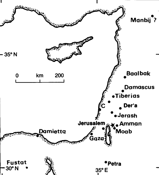
Fig. 2.6 747 January 18, Dead Sea. (from Ambraseys et al, 1994)

747 January 18 Dead Sea

A large earthquake centring in the Dead Sea region was felt in Egypt (see Figure 2.6). Some damage was caused in Damietta; in Fustat the shock was strongly felt and caused fear but no damage.1

There is considerable confusion over the dating of this event, which the Arabic sources put in 130 H (began 11 September 747),2 and January 748 has recently been proposed as the correct date.3 The effects of the earthquake are frequently confused with those of another event that affected parts of Syria two years later.4

Footnotes

1 Sawirus b. al-Muqaffa' (ed. Evetts), p. 139-40. He gives the date 21 Tuba/16 January; Agapius, p. 521 (who does not mention Egypt) has Kanun II/January. Neither specify the year.

2 Caetani, V, 1649 (re- 129/747?), 1664-5 (re. J 30/748). Sibt b. al-Jauzi, fol. 235VO, and al-Dhahabi, V, 39-40 both have 130 H. Though late sources, they are generally reliable. Al-'Ulaimi (ed. Najaf), I, 237-8, has Ramadan 130/May 748. See also al-Suyuti, pp. 23-4/9-10; Taher (1979), p. 18/28-30.

3 See Russell (1985), pp. 48-9, with a detailed discussion of the non-Muslim accounts, of which that by Theophanes (late eighth century) is the most important. The date 748 is also adopted by Gil (1992), pp. 89-90. Sieberg (1932b), p. 193, and Ben-Menahem (1979), p. 261, have 746 January 18, disregarding the systematic error in Theophanes

4 For the second earthquake, see e.g. al-Khwarazmi (fl. c. 847) in Baethgen (1884), p. 126, under 131 H (began 31 August 748). Recently, Tsafrir and Foerster (1992), who discovered a coin dated 131 H buried under earthquake destruction at Bet Shean, assign the year 749 to one event amalgamated from all sources.

References

Ambraseys, N. N., et al. (1994). The seismicity of Egypt, Arabia, and the Red Sea : a historical review. Cambridge, Cambridge University Press.

Abou Karaki (1987)

746

* (18 Jan. 746 A.D., Year 128 A.H.)?

Syrian and Egyptian Coasts, (AMBR2) Wednesday 18 Jan. 746 (Julian calendar), after 4:00 p.m. in the year 4506, SHVAT 23 of the Hebrew calendar, associated major earthquake at the Jericho fault, 32°N-35.5° E felt in Egypt, Syria, Arabia, Mesopotamia; major destructions in Tiberias, Jerusalem Lod, Arad, and in the monasteries to the north from the Dead Sea, to Jerash east of the Jordan; tsunami in the Dead Sea, destruction of the palace of Muslim Caliph Hisham near Jericho, I0 = XI, ML = 7.0 (BM1) as for the earthquake of the year 31 BC., this event could be correlated with the effects produced by an earthquake, evidenced by trench studies, on the Jericho Fault (Reches et Al. 1981)

NAJA:

  1. Here we have noticed an anomaly: indeed the date of 128 A.H.! is mentioned in (AMBR2) for this event while the date of 128 A.D., has already been mentioned for another event according to (will). A comparison between the descriptions relating to these two dates and the elements we currently have do not allow us to know if it is a type I error in (Will) or if it is on the contrary a simple coincidence between these two dates.

  2. The effects of earthquakes are visible everywhere in Jerash (27 km east of the Jordan).

    We were able to see these destructions, which, despite restoration work, are still very evident. We will come back on the one hand to this aspect and on the other hand to the earthquake of the year 746 as it is described in (BM1) in light of the earthquake discussion that follows.
French

* (18 Jan. 746 apr. J.C, Année 128 apr. H.) ?

Côtes syriennes et Egyptiennes, (AMBR2) Le mercredi 18 Jan. 746 (calendrier julien), après 16 h de l'année 4506, le 23 SHWAT du calendrier hébreu, séisme majeur associé à la faille de Jéricho, 32°N-35°,5E ressenti en Egypte, en Syrie, en Arabie, en Mésopotamie; ,destructions majeures à Tibérias, Jerusalem Lod, Arad, et dans les monastères au nord de la Mer Morte, à Jérash à l'est du Jourdain ; tsunami en Mer Morte, destruction du palais du Calife musulman Hisham près de Jéricho, I0 = XI, ML = 7,0 (BM1) comme pour le séisme de l'année 31 av. J.C, cet événement pourrait se corréler avec les effets produits par un séisme, mis 'en évidence par des études de tranchées, sur la faille de Jéricho (Reches et AL. 1981)

NAJA :

  1. Ici nous avons noté une anomalie : en effet la date de 128 apr. ! H est mentionnée dans (AMBR2) pour cet événement alors que la date de 128 apr. J.C.,a été déjà mentionnée pour un autre événement d'après (will). L a comparaison entre, les descriptions relatives à ces deux dates et les éléments dont nous disposons actuellement ne nous permettent pas de savoir s'il s'agit d'une erreur du type I dans (Will) ou s'il s'agit au contraire d'une simple coïncidence entre ces deux dates.

  2. Les effets de tremblements de terre sont visibles partout à Jérash (27 km à l'est du Jourdain).

    Nous avons pu constater ces destructions, qui, malgré des travaux de restauration, sont encore très évidentes. Nous reviendrons d'une par sur cet aspect et d'autre part sur le séisme de l'année 746 tel qu'il est décrit dans (BM1) à la lumière de la discussion du séisme qui suit.

748

* J = 19 MAY ±15 748 A.D., Ramadan 130 A.H.

  • In the month of Ramadan in the year 130 AD, after the break of fasting. Paroxysm in Jerusalem, Damascus is damaged. From a long description in (TAHA), we can conclude that at least 3 close shocks occurred. (Naja: our formula gives J = 19. MAY ± 15 days. 748, calculations reported on the 15th of the month of Ramadan, hence an uncertainty of a fortnight)

  • In (PTAH) there is an illustration of an error type II potential: indeed according to (PTAH)

  • Ramadan 130 A.H., the year 747 A.D., Jerusalem I = IX (PTAH)

  • 131 A.H., the year 749, DAMASCUS (PTAH).
We notice that the conversion of dates with a formula that is too approximate has thus resulted in two dates which cannot correspond in reality, namely Ramadan 130 AD H and 747 AD.. We have seen that, according to the exact calculation, the date, according to the Julian calendar, it should be mid-748. We estimate that this is probably how doublets occur, due to type II errors. It is also reasonable to assume that some references will mention the year 747 exclusively. Now, if we try to find by the application of a formula that is too approximate, the date corresponding to the year 747 AD., in the Muslim calendar, we arrive, by applying the formula (Pareja 2) for example, to the value 128.9, a value which is likely to become 128 A.H.; we believe that this could be the concrete example that allows us to ask ourselves seriously the question of whether the "events" of 746 AND 748 do not simply correspond to a single main major earthquake. Before concluding on this point, we continue the analysis of the effects of this major earthquake according to the various authors.

During the earthquake of the year 130 A.H., the east and west walls of the Al-Aqsa mosque in Jerusalem were destroyed; the mosque was repaired. But, destroyed again on the occasion of another earthquake, it was then rebuilt, its length diminished and its width increased at the time of the Muslim Caliph, AL-MANSOUR (alias Al-Muhtadi), who became Caliph on the 6th. Dhu al Hijjah 158 A.H., (NAJA: D=7 OCT. 775), (TAHA, TAHF)

In the year 131 A.H., several new shocks in Damascus (AMBR1)

NAJA: We have highlighted a type I error in (BM1) which associated the year (130 A.D.) an earthquake linked to faults in the Bekaa area, an earthquake felt strongly in Damascus
French

* J = 19 MAI. + 15 j. 748, ramadan 130 apr. H

  • Au mois de ramadan de l'an 130 apr.H, après la rupture du jeûne. Paroxysme à Jerusalem, Damas est endommagée. A partir d'une longue description dans (TAHA), on peut conclure que au minimum 3 chocs rapprochés se sont produits. (Naja : notre formule donne J = 19. MAI + 15 jours. 748, calculs rapportés au 15 du mois du ramadan d'où une incertitude d'une quinzaine de jours)

  • Dans (PTAH) on trouve l'illustration d'une erreur potentielle du type II : en effet d'après (PTAH)

  • ramadan 130 apr. H, l'année 747 apr.. J.C, Jerusalem I = IX (PTAH)

  • 131 apr. H, l'année 749, DAMAS (PTAH).
On remarque que la conversion des dates avec une formule trop approximative a ainsi abouti à deux dates qui ne peuvent se correspondre en réalitétà savoir ramadan 130 apr. H et 747 apr. J.C. Nous avons vu, que, selon le calcul exact, la date, d'après le calendrier Julien, devrait être la mi-748. Nous estimons que c'est probablement ainsi que se produisent les doublets, dûs aux erreurs du type II. Il est par ailleurs raisonnable de supposer que certaines références vont mentionner l'année 747 exclusivement. Maintenant, si l'on tente de retrouver par l'application d'une formule trop approximative, la date correspondant à l'année 747 apr. J.C., en calendrier musulman, on aboutit, en appliquant la formule (Pareja 2) par exemple, à la valeur 128,9, valeur qui a toutes les chances de devenir 128 apr. H.; nous pensons qu'il pourrait y avoir là l'exemple concret qui permet de se poser sérieusement la question de savoir si les "événements" de 746 ET 748 ne correspondent pas simplement à un seul séisme majeur principal. Avant de conclure sur ce point, nous poursuivons l'analyse des effets de ce séisme majeur d 'après les différents auteurs.

Lors du séisme de l'année 130 apr. H, les murs Est et Ouest de la mosquée Al-kkâa à Jérusalem ont été détruits; la mosquée fut réparée. Mais, détruite à nouveau à l'occasion d'un autre tremblement de terre, elle a été alors reconstruite, sa longueur diminuée et sa largeur augmentée à l'époque du calife musulman, AL-MANSOUR (alias Al-Muhtadi), devenu Calife le 6. Dhu al Hijjah 158 apr. H, (NAJA : J = 7 OCT. 775), (TAHA, TAHF)

En l'année 131 apr. H, plusieurs chocs nouveaux à Damas (AMBR1)

NAJA : Nous avons souligné une erreur du type I dans (BM1) qui a associé l'année (130 apr. J.C.) à un séisme lié aux failles de la zone de la Békaa, séisme ressenti fortement à Damas
  • ML = 6,1 (BM1), alors qu'il a calculé
  • ML = 7,3 pour l'événement de l'année "746"
En conclusion, nous pensons que, d'après la discussion ci-dessus concernant les erreurs du type II, l'hypothèse que toutes les descriptions qu l'on trouve dans la littérature, relatives aux séismes de la période 746 à 749 apr. J.C. soient en fait dues à un unique séisme majeur, et à ses conséquences, nous semble une hypothèse raisonnable, la date la plus probable de l'événement majeur étant le 19 -MAI. 15 de l'année 748. Cette conclusion est encore confirmée par les remarques suivantes:
  1. La date 746 apr. J.C. est une date vraissemblablement calculée d'après la date approximative de 128 apr. H. (voir AMBR2).
  2. (BMI) mentionne l'année 746 comme étant la date d'un tremblement de terre majeur ayant une magnitude ML = 7,3 (maximum pour cette zone), et il ne mentionne pas d'événement majeur pour l'année 748 alors que c'est l'inverse dans (TAHA, TAHF, PTAH) ; or cela, en soi, est une anomalie notable qui indique que ces deux "séismes" majeurs ne font en réalité qu'un.
  3. Sans que cela soit absolument exclu, mais pour des raisons physiques, il nous semble extrêmement improbable que deux événements de Magnitude pratiquement maximale pour une zone donnée, se soient produits dans la même zone, séparés par un laps de temps aussi réduit (2 années) et (ML > 7).
  4. En dehors de l'identité de la zone macrosismique dans les deux descriptions relatives aux deux dates il y a un élément de convergence supplémentaire, c'est "le temps origine" du séisme, d'une part après 16 h d'après (BM1), et d'autre part la rupture du jeûne d'après (TARA) : ces deux heures sont tout à fait compatibles.
Il reste à savoir si la date mentionnée dans (BM1) d'après le calendrier hébraïque est une date originale ne correspondant donc pas à une date calculée. Dans ce cas, la conversion de cette date en son correspondant du calendrier Julien ou selon l'Hégire pourrait bien trancher cette question, qui n'est pas simple, le calendrier hébraïque étant un calendrier lunaire particulier, dont l'année est constituée de 12 ou de 13 mois selon que l'année est commune ou embolisme- voir, pour un aperçu au sujet des calendriers, Ephémérides Astronomiques 1967

Cette discussion souligne à la fois la nécessité d'éviter l'utilisation de formule. trop approximave de conversion - des dates, et l'importance, en matière de sismicité historique, d'indiquer si une date proposée est originale ou par contre calculée, cela afin d'évitér des erreurs multiples, qui ont sérieusement affecté la représentativité des échantillons statistiques, fondés sur les données de la sismicité historique, jusqu'à présents avec les conséquences qui en découlent en matière d'implications sismotectonique, - nous y reviendrons - .

References

Abou-Karaki, N. (1987). Synthèse et carte sismotectonique des pays de la bordure Orientale de la Méditerranée: sismicité du système de foilles du Jourdain – Mer Morte, University of Strasbourg, France. Ph.D. Diss.

Russell (1985)

The Earthquake of January 748

[JW: Warning - Russell (1985) made a litany of chronological errors and omissions some of which are commented on below]


An account of this earthquake in Theophanes' Chronographia reads:

This year, on the 18th day of the month of January at the 4th hour, a great earthquake occurred in Palestine, around the Jordan, and in all of Syria, to such an extent that many innumerable and countless people perished in its power. and churches and monasteries collapsed, and all around the greatest of holy places there were deserted cities" (1839: 651).
The date given was A.M. 6238, dating this earthquake to January 18, 747. However. Theophanes noted the initial Abbasid revolt against Marwan prior to presenting his earthquake narrative, dating the revolt to 745/6 (A.M. 6237; 1838: 650). The commonly accepted date is June 747 as derived from Arabic sources (Hitti 1951: 530), which suggests the possibility of an error in Theophanes' dating.

Cedrenus also recorded this earthquake, largely replicating the previous account and dating of Theophanes.
In the 6th year there was a great earthquake in Palestine, and towards the Jordan, and throughout all of Syria, on the 18th day of January at the 4th hour. Many thousands of people perished, and churches and monasteries collapsed, from the greatest of holy places through deserted cities (1839: 7)
The sixth year of the reign of Constantine V would have been from June, 746 through May, 747, but this dating is ultimately derived from Theophanes (1839: 635). [JW: Theophanes and Cedrenus wrote about two earthquakes which Theophanes dated to AMa 6238 and 6241]

Another account of this earthquake exists in a 10th century Arabic manuscript on the history of the patriarchs of the Coptic Church of Alexandria by Severus Ibn al-Muqaffa, bishop of Ashmunein (fl. ca. 955-987). Evett translates the relevant passage:
And that night there came great wrath from God, for there was a great earthquake in the land, and many houses were ruined in all the cities; and none was saved from them, not a single soul; and likewise on the sea many ships were sunk on that night. This happened all over the East, from the city of Gaza to the furthest extremity of Persia. And they counted the cities that were wrecked that night, and they were six hundred cities and villages, with a vast destruction of men and beasts. But the land of Egypt was uninjured, except only Damietta. And at Misr there was only great fear, without any death or ruin of houses; for though the beams in the doorways and walls were moved out of their places, they went back again to their places after two hours (Severus ibn-al-Muqaffa 1910: 139-40).
Al-Muqaffa presented this narrative while recounting events in the life of the patriarch Michael 1 (744-768). However, according to his account, this earthquake occurred on the 21st of Tuba (1910: 139), the Arabic name for the Egyptian month of Tybi. Since this month began on the 27th of December (see Bickerman 1974: 50), the 21st of Tuba would have been the 16th of January [JW:Except during Coptic Leap years when it is 17 January - which was the case in 748 CE]. Al-Muqaffa also noted the initial Abbasid revolt against Marwan (1910: 134) prior to his presentation of the earthquake narrative, thereby suggesting that this earthquake occurred on January 16, 748 according to the accepted date of the initial Abbasid revolt.

Two other accounts further support a 748 date. The first is given in the Chronicle of Michael the Syrian. This is also the most regionally detailed account of this earthquake. Chabot's French translation of the relevant Syriac text reads:
Au milieu de ces choses, i1 y eut a Damas un tremblement de terre qui dura des jours et qui la secoua comme la feuille des arbres. Il y avait a Beit Qoubaye (?) une fortresse qui avait ete bate par Hadidjad], fils de Yousef et pour laquelle it avait fait de grandes depenses. Elle fut renversee de fond en comble et plus de 80 personnes y furent suffoquees; dans la ville meme, beaucoup perirent. Dans la Ghautah et a Dareiya plusieurs mvriades de gens perirent. Bocra, Nawa, Der at. Ba'albek furent totalement englouties.

Dans la region de Balqa, c'est-a-dire de Mo'ab, y avait une fortresse situee sur le rivage de la mer, dans la-quelle habitaient des Taiyave yemenites: quand les flocs de la mer se heurterent contre elle, ils l'arracherent de ses fondements. et la projetereint a trois milles.

Ce tremblement de terre detruisit la ville de Tiberiade, a l'exception de la maison d'un hommc nomme Isa. Il y renversa trente synagogues des Juifs, et de merveilleuses chases naturelles. Les thermes, edifice admirable, bati par Solomon, fils de David, furent renverses et s'ecroulerent.

Pres du mont Thabor, un village se desplaca de quatre milles, avec ses maisons et ses constructions, sans qu'une pierre ou un peu de pise tomhat de ses batisses; et pas un homme n'y peril, ni aucun animal, pas meme une poule.

La source d'eau qui etait a cote de Jericho s'eloigna de sa place de six milles.

A Mabboug, le tremblement survint au moment de l'oblation; les hommes et les betes furent tues, car les grandes eglises furent renversees ainsi qu les murs (1901: 509-10).
Since Michael recorded these events for the year A.G. 1059, a date between September 747 and August 748 is suggested. [JW: Michael did not supply a date and his chronology is mangled in this part of his book] The second supportive account comes from the 11th century Chronographia of Elias of Nisibus.

Further, there were many earthquakes and regions gave way. And miraculously. a sillag adjacent to Mount Thabor was displaced four miles away from its own location along with houses and their possessions, and not one piece of wall plaster fell from those houses, and not a single person perished in it, nor animal nor cock. And further, the church of the Jacobites in the city of Mabbug collapsed on Sunday at the time of the Eucharist, and many people perished in it (1954: 82).
The date of A.G. 1059 given in Elias' text would again place the occurrence of this earthquake between September 747 and August 748 [JW: Elias did not date it to A.G. 1059. He dated it to A.H. 131 and used a date in the A.G. calendar - 30 Ab A.G. 1059 to reference, more or less correctly, the start of A.H. 131]. Finally, a 748 date agrees with that given by the 16th century Egyptian polygrapher As-Soyuti for a severe earthquake in Damascus (A.H. 130 = September 747 through August 748; Ambraseys 1962: 78) [JW: As-Soyuti provided dates of A.H. 130 and A.H. 131], as well as the "quake in the sabbatical year" apparently recorded in Talmudic literature (Ben-Dov 1976: 101; Mazar 1975: 269).

While a final resolution of this temporal problem cannot yet be offered, a 748 date is probable and has been adopted here. However, regardless of whether a 747 or 748 date is ultimately determined to be correct, only one earthquake occurred in the study area during this period.

As suggested for the earthquake of July 9, 551, the region affected by that of 748 apparently stretched from northeastern Egypt through northern Mesopotamia. The 748 earthquake has been correlated with destruction evidence at Khirbet al-Mefjer (Baramki 1942), Pella (Smith 1973: 166), and Jerusalem (Ben-Dov 1976: 101; Mazar 1975: 269). The final destruction of the basilica at Mt. Nebo also appears to correlate with this earthquake (Schneider 1950: 2-3), as do the collapsed Omayyad structures uncovered in 1949 on the Amman citadel (Harding 1951). At Jerash, this earthquake apparently brought an end to the impoverished "squatter" occupation in the Church of St. Theodore (Crowfoot 1929: 25. 1938: 221) and parts of the churches of St. John the Baptist, St. George, and SS. Cosmas and Damianus (Crowfoot 1938: 242, 244). Finally, Umm al-Jamal apparently suffered damage at this time and was subsequently abandoned (de Vries 1981: 65, 71).

References

Russell, K. W. (1985). "The Earthquake Chronology of Palestine and Northwest Arabia from the 2nd through the Mid-8th Century A.D." Bulletin of the American School of Oriental Research 260: 37-59.

Russell, K. W. (1981). The earthquake chronology of ancient Palestine and Arabia from the 2nd to the 8th century A.D. Anthropology. Salt Lake City, UT, University of Utah. MS.

Other Earthquakes

Nicea 740 CE

Ambraseys (2009)

AD 740 Oct 26 Nicaea

This was a destructive earthquake in the eastern part of the Sea of Marmara. Many churches, monasteries, public buildings and private houses in Bithynia were destroyed or ruined, with a great loss of life.

In Bithynia the walls particularly of Nicomedea (Izmit), Praenetos (now Karamursel) and Nicaea (Iznik) were seriously damaged to the extent that they required immediate restoration. It is said that in Nicaea only one church was left standing.

In Constantinople the shock caused damage to buildings, houses and, in particular, free-standing structures: the statues of Attalus and Constantine at the Gate of Attalus, that of Theodosius at the Golden Gate and the statue of Arcadius on the column in the Forum were thrown to the ground. The church of St Irene was damaged, together with many others and the nearby walls of the city. Also the interior of St Sophia was probably affected, but details are lacking. The earthquake caused a breach in the land walls and a good part of the inner walls fell. Several extant inscriptions record the repairs executed by Leo III.

So extensive and widespread was the damage that, to meet the extraordinary expenditure for repairs and reconstruction, the emperor was obliged to impose additional taxation. The event was commemorated by the church.

In some places (not named) the sea drew back from the shores, changing the coastline permanently. It is not clear whether this was the result of the uplift of the coast.

Aftershocks probably continued for a year, and people possibly camped outside the city for up to two years.

Theophanes, who gives most of the details of the earthquake, dates it to a.M. 6232, 26 October, fourth day, eighth hour = AD 740 (MB) Wednesday 26 October, 2 pm. Nicephorus Callistus adds that the church of St Irene, near the Hagia Sophia, was destroyed in particular, and, like Theophanes, notes that aftershocks lasted for a year. Georgius Monachus (writing in the ninth century) claims that aftershocks lasted for two years, and adds that villages in Thrace were also damaged. Cedrenus (writing in the eleventh or twelfth century) largely copies Theophanes, but puts the duration of the aftershocks at 11 months.

Michael the Syrian gives a brief notice of this event, dating it to a.S. 1050 (AD 738–739), a year too low. The same author has a double of this earthquake associated with the Palestine/Syria earthquake of AD 747. The Armenian version of Michael the Syrian has a wildly exaggerated account, in which this event is syncretised with all the mid-eighth-century Middle Eastern earthquakes.

Another indication of the human upheaval caused by this earthquake is that it is commemorated in the Byzantine liturgical calendar to this day, together with the Constantinople earthquake of 25 October 989; it also appears in the ninth-century Greek Menology of Basil I.

Two inscriptions commemorating Leo’s rebuilding survive on the old walls of Constantinople: on the seventh tower of the Theodosian Wall, north of the Sea of Marmara, and on the ninth tower north of the Golden Gate (Millingen 1899, 98) For additional details see also Meg. Chron. 314–315; Zon. xv.4 /i. 1324–1325; Nersessian (1940, 104–107); and Muller-Wiener (1977, 87, 113, 293, ¨ 250, 297).

Note that in the eighth century the district (thema) of Thrace, which is mentioned by Georgios Monachos as having been damaged by the earthquake, included the region of Constantinople itself and consequently Georgios does not mean that damage extended to the west of the city into modern Thrace in Greece and Bulgaria.

Papazachos and Papazachou (1997, 7, 20, 143), misled by Samothrakis (1963), consider that damage extended 300 km from Constantinople to Anchialos and further west to Veroia (Kara Feria or Stara Zagora) in Bulgaria. Papazachos and Papazachou also confuse Stara Zagora with Veria in Macedonia, which is 700 km from Constantinople (Papazachos and Papazachou 1989, 322).

Notes

‘(a.M. 6232) And in that year a great and terrible earthquake happened in Constantinople on the 26th of the month of October, in the 9th indiction, the 4th day, the 8th hour. Churches and monasteries fell, and many people died. The statue of Constantine the Great with the statue of Attalus and the Atalian Gate also fell, and the statue of Arcadius on the column of the Xerolophus; also the statue of Theodosius the Great at the Golden Gate and the land walls, and towns and villages in Thrace, and Nicomedea in Bithynia, Praenetus, and Nicaea, where a single church survived. The sea retreated from its bounds into various places, and the earthquake continued for twelve months.

And then the Emperor, seeing that the walls of the city had fallen, addressed the people, saying, “You do not have much for rebuilding the walls, and so I have put this matter to the district governors. They will demand a miliarision in the standard coinage, and the Empire will take the money and with it rebuild the walls.” And thus the customary procedure of paying two surtaxes was successful.’ (Theoph. 412–413).


‘In the time between [the sending of the legation to the Chazars’ leader and the sending of Leo’s daughter to marry the Chazar leader’s son] an earthquake struck Byzantium, also severely affecting other cities and villages. And it threw down many houses, holy churches and colonnades, some of which were razed to their foundations. In addition it damaged the splendid church, which is dedicated to St Irene, located very near the Great Church [the Hagia Sophia]. And the statue of Arcadius, a Roman ruler of old, which stood on a carved column on the Xerolophus fell down to the ground. The shaking lasted for a year, with the result that many of the citizens went out beyond the walls and dwelt in huts.’ (Niceph. Call. post Maur. 66).


‘At these times a great and most frightening earthquake happened, and many churches and houses and the land walls of the city and many prisons fell, together with the villages of Thrace. And countless people died, and the earth shook for two years, so that the sea drew back from its bounds . . .’ (Georg. Mon. PG 636/924).


‘In the 24th year [of Leo] the market-places (agorai) were burned by the Hieracites, and many of them were executed. On 26th October, which is the feast of St Demetrius, on the 4th day, at the 8th hour, a great and terrifying earthquake happened in Constantinople and churches, monasteries and houses fell, and many people died. Also the statue of Arcadius in the Xerolophus and many other [statues?], the land walls of the city, and cities and villages in Thrace, together with Nicaea, Nicomedea and Praenetus, all fell. The sea left its bounds in certain places. The earthquake lasted for eleven months.

When the Emperor saw that the walls of the city had fallen, he addressed [the people] saying, “You, the citizens, are not able to restore the walls, but we have given orders to the district governors to demand one miliarision in the standard coinage, and the Empire will take this and rebuild the walls.” And this customary procedure was successful, producing [the standard] surtax (ta dikerata) for the district governors. This surtax (keratia) was 12 folles or nummi [= sestertii].’ (Cedr. 801/880).


‘In the year 1050 there was an earthquake in Constantinople; the most part of the city collapsed.’ (Mich. Syr. xi. 22/ii. 504).


‘At Constantinople, the statues of the Emperors collapsed together with most of the buildings. It was the same in Nicaea and in other cities.’ (Mich. Syr. xi. 23/ii. 511). ‘[Same time as Palestine earthquake] Three-quarters of the city of Constantinople fell in ruins; the town of Nicaea was completely destroyed, together with several other cities in Bithynia.’ (Mich. Syr. Arm. 259).


‘[26 October] On the same day we commemorate the love shown to us men in the affliction of the terrible and unspeakable threat of the earthquake [which occurred] owing to our many sins in the 6249th year, in which was the 5th cycle of the moon, the 16th of the sun, the 9th indiction, in the reign of the lawless enemy of icons, Leo of Isauria.’ (Synax. CP. 166/2).


‘On the same day [26 October]: Commemoration of the great earthquake.

In the 24th year of the Emperor Leo the Isaurian [Leo III], in the 9th indiction, in the month of October, on the 26th day, on the Feast of St Demetrius, Constantinople was shaken by a terrible earthquake, so that all the houses and churches collapsed, and a countless multitude of people were killed. And so to commemorate this terrible earthquake we have instituted rogations, in which we process to the great and holy shrine of the most immaculate and glorious Mother of God, Mary ever Virgin, which is in Blachernes . . .’ (Men. Bas. 146/129).


‘On the seventh tower of the Theodosian Wall, north of the Sea of Marmara: “Leo with Constantine, wielders of the sceptre, erected from the foundations this tower which had fallen”.

On the ninth tower north of the Golden Gate, in brick letters: “Many be the years of Leo and Constantine, Great Kings and Emperors”.’ (Millingen 1899, 98).

References

Ambraseys, N. N. (2009). Earthquakes in the Mediterranean and Middle East: a multidisciplinary study of seismicity up to 1900.

Yemen 742 CE

Ambraseys et al (1994)

742 Yemen

Byzantine authors of the ninth and tenth centuries describe an earthquake in the Spring of 742 in the 'desert of Sava' or 'Sava'.1 The latter may correspond to the monastery of Savva, south of Jerusalem; but Michael the Syrian (twelfth century) says the earthquake occurred in the 'desert of the Taiyeye' (Arabs), which can be equated with Sava or Saba. This is probably somewhere round the edges of the desert between Shabwa in Hadramaut and Ma'rib. The earthquake caused large landslides and many villages were overwhelmed by collapsing mountain sides.2

The date and details of this event have been greatly misrepresented in some earthquake catalogues, where it is located in Libya, 4000 km away.3 However, a location in the Yemen is supported by the fact that this notice is followed by the account of another event in the Yemen during that year.4

With so few details, it is clearly difficult to suggest either an epicentral location or area of perceptibility for this event, which should have been relatively large, considering that its occurrence is recorded by chroniclers writing in Constantinople and Upper Mesopotamia.

Footnotes

1 Theophanes, p. 349/641; Agapius, p. 510/250; Cedrenus, p. 460/ II, 5; see also Ambraseys and Melville (1983). 'Byzantine' authors do not again show an interest in events in Arabia till the extension of the Ottoman Empire into that region at the turn of the sixteenth century.

2 Michael the Syrian, XI, 22/II, 507.

3 Sieberg (1932a), p. 872, puts this event near Murzuq in Libya in 704 and again (1932b), p. 188, in 742, saying much damage was caused in Egypt by an earthquake located in Libya. Sieberg misquotes the sources used by earlier cataloguers, such as Hoff (1840), pp. 195 - 6, and Mallet (1853), p. 11. The account of 600 towns being destroyed in fact follows Sawirus's account of the earthquake of 747, see next entry. Sieberg's mislocation is followed by later writers, e.g. Campbell (1968) and Kebeasy (1980).

4 Michael the Syrian mentions that monkeys attacked and ate some people in the Yemen!

References

Ambraseys, N. N., et al. (1994). The seismicity of Egypt, Arabia, and the Red Sea : a historical review. Cambridge, Cambridge University Press.

Triantafyllou et al. (2022)

4.3 Mid-eighth century: earthquakes and tsunami in Palestine

4.3.1 Information sources

According to Epitome (Part Δ, p. 289), A’sam became the 17th successor of Mohammed in the year a.H.105 (AD 723/724) but he was extremely heartless against the Orthodox Higher Priests: “And due to all these bad things the wrath of God arrived, and a great, terrible earthquake happened; because of the great seismic turmoil at sea many ships sank, while in the land many animals died due to the excessive motion of the Earth. In the East six hundred cities destroyed. It is said that the ruination of the East started at that time”. This account implies that the earthquake was of large magnitude and caused several effects, which are described later in light of more information sources.

Several Byzantine, Arabic, Syrian and Jewish documentary sources make reference to a series of strong, disastrous earthquakes that shook eastern Mediterranean around the mid-eighth century. The relevant sources were reviewed and examined by many modern authors, including Ben-Menahem (1979), Guidoboni et al. (1994), Karcz (2004), Ambraseys (2005, 2009), Sbeinati et al. (2005) and Salamon et al. (2007). The earthquake reported in Epitome perhaps is one of those earthquakes. The most important event has been a great earthquake that affected Palestine, Jordan and Syria. However, in modern seismological and historiographic literature no general consensus exists neither regarding the number of single seismic events that occurred in that period nor about the events dating. Nevertheless, starting from the little information that Epitome provides we investigated the most candidate earthquake event(s). This effort has been based on the comparison of Nektarios’ narration with the accounts existing in other sources regarding earthquakes that may have occurred in that period of time.

4.3.2 The dating issue

Starting with the chronology issue, from Epitome we learn that the great earthquake happened after AD 723/724 but certainly before the death of A’sam (AD 742/743) as it derived from another passage: “A’sam understood that this great calamity was due to the wrath of God and let the Higher Priests alone causing them no further harm”. No large earthquakes were dated in the eastern Mediterranean in the early period of that time interval. On the contrary, it is likely that more than one earthquakes occurred in the late period of that interval and beyond up to around AD 757. However, the many different dating systems used in the various documentary sources complicates the earthquake dating issue, thus the date of the great earthquake falls in the range from AD 737/738 up to 757/758. From detailed historiographic analysis, Guidoboni et al. (1994) suggested that the great earthquake of that period occurred in the morning of AD 18 January 749, which was also supported by Nur and Burgess (2008), on the basis of archaeoseismological interpretation, and adopted by Papadopoulos et al. (2014) and Papadopoulos (2016). An important archaeological discovery is the clear evidence of a powerful earthquake that affected the city of Ramla, to the west of Jerusalem, and dated by firm ceramic evidence around AD 749 (Gorzalczany and Salamon 2018). On the other hand, Karcz (2004), Ambraseys (2005, 2009) and Salamon et al. (2007), based mainly on the Chronography by the Byzantine Theophanes, which is the source nearest to the events, preferred AD 18 January 746 or 747. Other important earthquake events were dated in AD 749 or in AD 750 as well as on AD 9 March 757 (Karcz 2004; Ambraseys 2009).

Of interest is that the geometry, kinematics, and activity of the faults crossing the town of Tiberias, studied through an integrated structural, archaeoseismological and geophysical approach, revealed that this fault segment was activated in the AD mid-eighth century (Ferrario et al. 2020). Based on macroseismic information for an earthquake dated in AD 746, Riad et al. (2004) estimated maximum intensity as high as XI in Balqa, Jordan, and magnitude 7.7, which was adopted by Sawires et al. (2016) too. El-Isa et al. (2015) suggested two major earthquakes occurring in AD 746/747 and in AD 748/749 with estimated magnitudes 7.4 and 7.2, respectively. Zohar et al. (2017) placed the earthquake in 749/750 and suggested average magnitude of 7.2 as calculated from several previous estimates.

4.3.3 Tsunami

The Nektarios’ narration that “because of the great seismic turmoil at sea many ships sank” is an evidence of a destructive tsunami that possibly associated the earthquake. However, the tsunami place is not provided. This account looks like similar to the accounts provided by earlier texts, which in a chronological order are those by Sawirus (Severus) ibn-al Muqaffa (AD tenth century), a Coptic Orthodox Bishop of the AD tenth century, Michael the Syrian (AD 1126–1199), al-Makin (AD 1208–1273) and Chronikon (1234), a post-AD 1234 anonymous West Syriac universal history (see a collection of accounts in Antonopoulos 1973, 1979; Guidoboni et al. 1994 and Ambraseys 2009). These sources make also reference to an extraordinary storm in the sea that destroyed many towns and villages. However, it is not clear to which earthquake the tsunami was associated with. According to al-Makin and Sawirus Muqaffa, as analyzed by modern authors (Antonopoulos 1973, 1979; Guidoboni et al. 1994; Karcz 2004; Ambraseys 2009), the great tsunamigenic earthquake was dated in a.H.120 (AD 737/738). Chronikon (1234) as well as Michael the Syrian dated the great earthquake in a.S. 1059, i.e. from AD October 747 to AD September 748 according to the Seleucid (Greek) dating system. It is noteworthy, how ever, that in his earthquake accounts for that period, Theophanes does not make reference to an extraordinary storm in the sea or to similar phenomena.

On the other hand, the similarity between the above accounts indicates that one or more authors likely copied previous one(s). As Manousakas (1947) noted, al-Makin was in fact the main source for Nektarios as regards the Parts B and Δ of Epitome. The detailed historiographic analysis by Ambraseys (2009) showed that at least three strong earthquakes may have occurred causing destruction from Egypt to northern Syria in the time interval from AD 746 up to AD 757. The largest has been the one of 18 January 746 that caused extensive destruction and various ground failures, like landslides and soil liquefaction, in many places of Palestine and Jordan. We tentatively suggest that this is the tsunamigenic earthquake described by the various sources examined earlier.

4.3.4 Earthquake effects

The Epitome’s account that “In the East six hundred cities were destroyed” may reflect the large extent of the destruction and the many human victims caused by the great earthquake in several settlements (see review in Guidobini et al. 1994; Ambraseys 2009). However, the statement “while in the land many animals died due to the excessive motion of the Earth”, or a similar one, has not been found in other documentary sources available. To interpret this point there is a need to understand the ground shaking mechanism that may have caused massive animal death. The strong ground motion alone certainly is not enough to explain such an effect. What Nektarios possibly meant is that animals were buried by large scale landslides and/or rock falls triggered by the great earthquake. Such phenomena are clearly described by Theophanes in his account for the year 748/749 in association to the specific earthquake. Animals sacrificed by falling buildings, as a result of the earth shaking, sounds reasonable as well. In fact, Michael the Syrian (466–467) reported that in M abbug, Mesopotamia, human beings and animals were sacrificed when during the oblation a strong earthquake occurred, which likely was the one of AD 749 or AD 750. This episode was also mentioned by Theophanes as happening in the year 748/749 and by al-Makin although these two authors provide different dates (see relevant quotations in Guidoboni et al. 1994 and Ambraseys 2009).

Paleoclimate - Droughts

References

References

Williams, J. (2024). "Mid-8th Century CE Seismic Sequences Along the Dead Sea Transform." Annals of Geophysics 67(1): SE101.

Supplemental Appendices for Williams, J. (2024). "Mid-8th Century CE Seismic Sequences Along the Dead Sea Transform." Annals of Geophysics 67(1): SE101.

Contextualising the earthquake of 749 CE From high definition archaeology to global history - abstracts

Contextualising the earthquake of 749 CE From high definition archaeology to global history - Event

Abou-Karaki, N. (1987). Synthise et carte sismotectonique des pays de la bordure Orientale de la Mediterranae: sismicite du systeme de foilles du Jourdain a Mer Morte, University of Strasbourg, France. Ph.D. Diss.

Ambraseys, N. (2009). Earthquakes in the Mediterranean and Middle East: a multidisciplinary study of seismicity up to 1900. Cambridge, UK, Cambridge University Press.

ANTONOPOULOS, J. (1980). "Data from investigation on seismic Sea-waves events in the Eastern Mediterranean from 500 to 1000 A.D." Annals of Geophysics.

Begin, Z. B. (2005). Destructive earthquakes in the Jordan Valley and the Dead Sea and their re-occurrence interval and the probability of their occurrence. Geol. Surv. Isr. Rep. GSI/12/2005. Jerusalem: 51.

Ben-Menahem, A. (1979). "Earthquake catalogue for the Middle East (92 BC-AD 1980) " Bollettino di Geofisica Teorica e Applicata 21: 245-313.

Ben-Menahem, A. (1981). "Variation of slip and creep along the Levant rift over the past 4000 years." Tectonophys. 80(null): 183.

Ben-Menahem, A. (1991). "Four Thousand Years of Seismicity along the Dead Sea rift." Journal of Geophysical Research 96((no. B12), 20): 195-120, 216.

Ferrario, M. F., et al. (2020). The mid-8th century CE surface faulting along the Dead Sea Fault at Tiberias (Sea of Galilee, Israel).

Guidoboni, E., et al. (1994). Catalogue of ancient earthquakes in the Mediterranean area up to the 10th century. Rome, Istituto nazionale di geofisica.

Kagan, E. J. (2011). Multi Site Quaternary Paleoseismology Along the Dead Sea Rift: Independent Recording by Lake and Cave Sediments, Hebrew University of Jerusalem.

Kagan, E., et al. (2011). "Intrabasin paleoearthquake and quiescence correlation of the late Holocene Dead Sea." Journal of Geophysical Research 116(B4): B04311.

Karcz, I. (2004). "Implications of some early Jewish sources for estimates of earthquake hazard in the Holy Land." Ann. Geophys. 47: 759-792.

Ken-Tor, R., Agnon, A., Enzel, Y., and Stein, M. (2001). "High Resolution Geological Record of Historic Earthquakes in the Dead Sea Basin." Journal of Geophysical Research 106(B2): 2221-2234.

Magness, Jodi, 1997, Synagogue Typology and Earthquake Chronology at Khirbet Shema, Israel, Journal of Field Archeology, Volume 24 Issue 2 (01 January 1997), pp. 211-220

Klinger, Y., et al. (2015). "5000 yr of paleoseismicity along the southern Dead Sea fault." Geophysical Journal International 202(1): 313-327.

Marco, S., et al. (2003). "Archaeology, history, and geology of the A.D. 749 earthquake, Dead Sea transform." Geology 31(8): 665-668.

Migowski, C., et al. (2004). "Recurrence pattern of Holocene earthquakes along the Dead Sea transform revealed by varve-counting and radiocarbon dating of lacustrine sediments." Earth and Planetary Science Letters 222(1): 301-314.

Meghraoui, M., et al. (2003). "Evidence for 830 years of seismic quiescence from palaeoseismology, archaeoseismology and historical seismicity along the Dead Sea fault in Syria." Earth and Planetary Science Letters 210(12): 35-52.

Reches, Z. a. H., D. F. (1981). "Holocene Seismic and Tectonic Activity in the Dead Sea Area." Tectonophysics 95: 75-89.

Russell, K. W. (1985). "The Earthquake Chronology of Palestine and Northwest Arabia from the 2nd through the Mid-8th Century A.D." Bulletin of the American School of Oriental Research 260: 37-59.

Rutenberg,Avigdor and Levy, Robert, DAMAGE ASSESSMENT: Some Comments on Seismicity in Israel, Performance Assessment & Damage to Historic Monuments in Jerusalem PROHITECH WP2 (Leader G. Altay). Haifa, Israel, Technion-Israel Institute of Technology

Schiller, E. (1978). The al Aqsa Mosque (in Hebrew). Jerusalem, Ariel Publishing.

Salamon, A., et al. (2011). "A critical evaluation of tsunami records reported for the Levant Coast from the second millennium bce to the present." Isr. J. Earth Sci. 58: 327-354.

Tsafrir, Y. and G. Foerster (1992). "The dating of the Earthquake of the Sabbatical Year of 749 C.E. in Palestine." Bulletin of the School of Oriental and African Studies 55(02): 231-235.

Wechsler, N., et al. (2009). "Estimating location and size of historical earthquake by combining archaeology and geology in Umm-El-Qanatir, Dead Sea Transform." Natural Hazards 50(1): 27-43.

Wechsler, N., et al. (2014). "A Paleoseismic Record of Earthquakes for the Dead Sea Transform Fault between the First and Seventh Centuries C.E.: Nonperiodic Behavior of a Plate Boundary Fault." Bulletin of the Seismological Society of America.

Wells, D. L. and K. J. Coppersmith (1994). "New empirical relationships among magnitude, rupture length, rupture width, rupture area, and surface displacement." Bulletin of the Seismological Society of America 84(4)

Zilberman, et al (2004). Neotectonic and paleoseismic study : Bet She'an Valley. Jerusalem, Geological Survey of Israel.

Zohar, M., et al. (2016). "Reappraised list of historical earthquakes that affected Israel and its close surroundings." Journal of Seismology: 1-15.

Zohar et al (2019) - updated catalog


Ancient Texts

Anastasius Bibliothecarius. PL 129. J.-P. Migne.

http://en.wikipedia.org/wiki/Anastasius_Bibliothecarius
http://www.newadvent.org/cathen/16002b.htm

Cedrenus, G., et al. (1838). Georgius Cedrenus, Ioannis Scylitzae ope, E. Weber.

http://books.google.co.uk/books?id=WM0GAAAAQAAJ
http://en.wikipedia.org/wiki/George_Kedrenos
https://archive.org/details/georgiuscedrenu00scylgoog

Anonymous "Chronicle of 1234."

http://www.doaks.org/research/byzantine/resources/syriac/chronicles#section-21
https://archive.org/details/AnonymiAuctorisChroniconAdAnnumChristi1234PertinensIVersioCSCO109OCR
https://archive.org/details/ChroniconAdAnnumChristi1234PertinensVolume2
https://archive.org/details/chroniconanonymi01chab
http://archive.org/stream/ChroniconAdAnnumChristi1234PertinensVolume2/Chronicon1234ChabotVol2#page/n123/mode/1up
http://archive.org/stream/chroniconanonymi01chab#page/n327/mode/1up
http://www.doaks.org/research/byzantine/resources/syriac/chronicles
http://en.wikipedia.org/wiki/Chronicle_of_1234
http://referenceworks.brillonline.com/entries/encyclopedia-of-the-medieval-chronicle/chronicle-of-1234-SIM_00201?s.num=76&s.rows=100

Chabot, J. B. (2010). Chronique de Denys de Tell-Mahre, Part, Kessinger Publishing.

http://books.google.com/books?id=VXzVYgEACAAJ
http://fr.wikipedia.org/wiki/Chronique_du_Pseudo-Denys_de_Tell-Mahr%C3%A9
https://archive.org/details/chroniquededeny00chabgoog

Elias, B. o. N. "Opus Chronologicum."

https://archive.org/details/OpusChronologicumByEliasBishopOfNisibis

Glykas, M. "Chronicle of events from the creation of the world to the death of Alexius I Comnenus."

http://en.wikipedia.org/wiki/Michael_Glycas
https://archive.org/details/michaelisglycae00leungoog

Gil, M. (1992). A History of Palestine, 634-1099, Cambridge University Press

Moshe Gil on Wikipedia

MichaelTheSyrian Chronicle.

https://archive.org/details/ChronicleOfMichaelTheGreatPatriarchOfTheSyrians
http://rbedrosian.com/Msyr/msyrtoc.html

Syrian, Michael the (1963). Chronique 4 volumes N. Chabot. Brussels.

https://archive.org/details/ChroniqueDeMichelLeGrand
https://archive.org/details/ChroniqueDeMichelLeSyrienT.1Fasc.1translation
https://archive.org/details/MichelLeSyrien2
https://archive.org/details/MichelLeSyrien3
http://www.roger-pearse.com/weblog/2009/02/26/michael-the-syrian-preface-to-his-history/ http://en.wikipedia.org/wiki/Michael_the_Syrian

Gregoras, N., et al. (2012). Nicephori Gregorae Byzantina historia: Graece et Latine, Cambridge University Press.

http://books.google.com/books?id=vfMb_RdGufUC
https://archive.org/details/byzantinahistor00bekkgoog
http://en.wikipedia.org/wiki/Nicephorus_Gregoras

Pseudo-Dionysus Works.

http://www.ccel.org/ccel/dionysius
http://www.ccel.org/ccel/dionysius/works.html

Mango, C. A., et al. (1997). The chronicle of Theophanes Confessor: Byzantine and Near Eastern history, AD 284-813, Clarendon Press.

http://books.google.com/books?id=6BIMAQAAMAAJ
http://en.wikipedia.org/wiki/Theophanes_the_Confessor
http://www.newadvent.org/cathen/14623a.htm
https://archive.org/details/TheChronologyOfTheophanes607-775
http://www.scribd.com/doc/202355147/The-Chronicle-of-Theophanes-Confessor-Byzantine-and-Near-Eastern-History-AD-284-813-Oxford-1997

Zonaras, J., et al. (2011). Ioannou Tou Zonara Epitome Historion Ioannis Zonarae Epitome Historiarum Cum Caroli Ducangii Suisque Annotationibus Edidit Ludovicus Dindorfius, BiblioBazaar.

http://books.google.com/books?id=8d0gywAACAAJ
http://en.wikipedia.org/wiki/John_Zonaras
https://archive.org/details/ioannoutouzonara03zonauoft


Ancient Arabic Texts

Dahab. Tarikh: al-Dahabii, Tarikh al-Islam, MS BL Or. 49 and 50; Paris MS Ar. 1581; Kitab al-'ibar fi khabar man ghabara, 5 volumes, ed. S. Munajjid, Kuwait, 1960-66; Kitab duwa al-Islam al-kabir, MS BM Or. 48-50, with Dhail ed. al-Sakhawi, Hyderabad, 1919; trans. A. Negre, Damascus 1979, p. 13.

(Sawirus), M. I. a.-M. (1943). History of the Patriarchs of the Egyptian Church. A. a.-M. and and Burmester. Cairo.

http://www.tertullian.org/fathers/severus_hermopolis_hist_alex_patr_00_eintro.htm
http://en.wikipedia.org/wiki/History_of_the_Patriarchs_of_Alexandria
http://en.wikipedia.org/wiki/Severus_ibn_al-Mukaffa
http://www.tertullian.org/fathers/severus_hermopolis_hist_alex_patr_00_intro.htm

al-Suyuti, J. a.-D. K. (1971). Kashf al-salsala 'an wasf al-zalzala. A. a.-L. Sa'adan. Fez.

http://makashfa.wordpress.com/2014/01/08/works-books-of-imam-jalaluddin-suyuti/
http://en.wikipedia.org/wiki/Al-Suyuti

al-'Ulaimi (1866 (A.H. 1283)). al-Uns al-jalil bi-tarikh al-Quds. wa'l-Khalil. Cairo.


Judaic Texts

Margalioth, M. (1941), ‘Dating the Seventh-year earthquake’, Bull. Israel Explor. Soc., 8, 97–104 (in Hebrew).

Margalioth, M. (1959), ‘A new document on the Seventh-year earthquake’, Tarbiz, 29, 339–344 (in Hebrew).

Tsafrir, Y., Foerster, G. (1992), ‘The dating of the ‘earthquake of the Sabbatical year’ of 749 C.E. in Palestine’, Bull. SOAS, 55, 231–235.

Gil, M. (1983), Palestine during the First Muslim Period 634–1099, 3 volumes, Tel Aviv: Ministry of Defence

Elitzur (2004) in Hebrew

Elizer (2005) in Hebrew


Samaritan Texts

Stenhouse, P. (1980). "The Kitāb al-Tarīkh of Abu'l Fath: a new edition."

"The Samaritan Chronicle of Abu '1 Fatch, the Arabic text from the MS in the Bodleian Library", DVJ, 2 (1863), pp. 304-335, 430-459.

The Kitab al-Ta'rikh of Abu 'l-Fath, Ph. D Thesis, Sydney University (1980).

The Kitab al-Ta'rikh of Abu 'l-Fath, Translated with Notes (The Mandelbaum Trust, Sydney, University Press 1985).

Crown, A. D. (1989). The Samaritans. Tübingen, J.C.B. Mohr (Paul Siebeck).