Tiberias - Water Reservoir
 Umayyad Water Reservoir of Tiberias
click on image to explore this site on a new tab in govmap.gov.il
- Fig. 6a Map of the southern
gate and reservoir sites from Ferrario et al (2020)
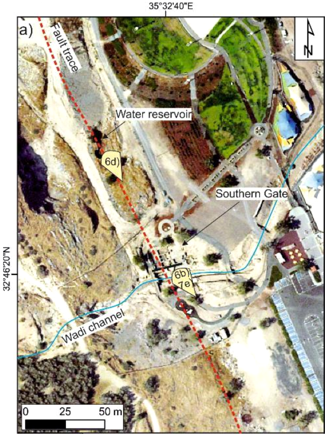 Figure 6a
Map of the Southern Gate and water reservoir sites, ca. 200 m S of the Theatre, along the Jordan Valley Western Boundary (JVWB) Fault strike, with indication of picture view angles and trace of total station profile. Fault trace is marked by red dashed line
Ferrario et al (2020) - Fig. 4 Map of Ancient Tiberias
from Ferrario et al (2020)
 Figure 4: Map of ancient Tiberias (modified after Hirschfeld & Gutfeld, 2008) with indication of the inferred lineament and trench position.
Ferrario et al (2015)
- Fig. 6a Map of the southern
gate and reservoir sites from Ferrario et al (2020)
Figure 6a
Map of the Southern Gate and water reservoir sites, ca. 200 m S of the Theatre, along the Jordan Valley Western Boundary (JVWB) Fault strike, with indication of picture view angles and trace of total station profile. Fault trace is marked by red dashed line
Ferrario et al (2020) - Fig. 4 Map of Ancient Tiberias
from Ferrario et al (2020)
Figure 4: Map of ancient Tiberias (modified after Hirschfeld & Gutfeld, 2008) with indication of the inferred lineament and trench position.
Ferrario et al (2015)
- Water Reservoir of Tiberias in Google Earth
 Water Reservoir of Tiberias
click on image to explore this site on a new tab in Google Earth - Water Reservoir of Tiberias on govmap.gov.il
Water Reservoir of Tiberias
click on image to explore this site on a new tab in govmap.gov.il
- Fig. 6d Fractures affecting
an Umayyad water reservoir from Ferrario et al (2020)
 Figure 6d
set of fractures affecting an Umayyad water reservoir, located in between the Theatre and the Southern Gate.
Ferrario et al (2020)
- Fig. 6d Fractures affecting
an Umayyad water reservoir from Ferrario et al (2020)
Figure 6d
set of fractures affecting an Umayyad water reservoir, located in between the Theatre and the Southern Gate.
Ferrario et al (2020) - Fig. 6a Map of the southern
gate and reservoir sites from Ferrario et al (2020)
Figure 6a
Map of the Southern Gate and water reservoir sites, ca. 200 m S of the Theatre, along the Jordan Valley Western Boundary (JVWB) Fault strike, with indication of picture view angles and trace of total station profile. Fault trace is marked by red dashed line
Ferrario et al (2020) - Fig. 4 Map of Ancient Tiberias
from Ferrario et al (2020)
Figure 4: Map of ancient Tiberias (modified after Hirschfeld & Gutfeld, 2008) with indication of the inferred lineament and trench position.
Ferrario et al (2015)
| Effect | Location | Image(s) | Description |
|---|---|---|---|
| Penetrative fractures in masonry | Umayyad Water Reservoir
Figure 6a Map of the Southern Gate and water reservoir sites, ca. 200 m S of the Theatre, along the Jordan Valley Western Boundary (JVWB) Fault strike, with indication of picture view angles and trace of total station profile. Fault trace is marked by red dashed line Ferrario et al (2020)
Figure 4: Map of ancient Tiberias (modified after Hirschfeld & Gutfeld, 2008) with indication of the inferred lineament and trench position.Ferrario et al (2015) |
Figure 6d set of fractures affecting an Umayyad water reservoir, located in between the Theatre and the Southern Gate. Ferrario et al (2020) |
|
- Earthquake Archeological Effects chart
of Rodríguez-Pascua et al (2013: 221-224)
 Earthquake Archeological Effects (EAE)
Rodríguez-Pascua et al (2013: 221-224)
| Effect | Location | Image(s) | Description | Intensity |
|---|---|---|---|---|
| Penetrative fractures in masonry | Umayyad Water Reservoir
Figure 6a Map of the Southern Gate and water reservoir sites, ca. 200 m S of the Theatre, along the Jordan Valley Western Boundary (JVWB) Fault strike, with indication of picture view angles and trace of total station profile. Fault trace is marked by red dashed line Ferrario et al (2020)
Figure 4: Map of ancient Tiberias (modified after Hirschfeld & Gutfeld, 2008) with indication of the inferred lineament and trench position.Ferrario et al (2015) |
Figure 6d set of fractures affecting an Umayyad water reservoir, located in between the Theatre and the Southern Gate. Ferrario et al (2020) |
|
VI + |