Tiberias Introduction
 Ancient Tiberias
click on image to explore this site on a new tab in Google Earth
| Transliterated Name | Language | Name |
|---|---|---|
| Tverya | Hebrew | טיבריות |
| Ṭabariyyā | Arabic | طبريا |
| Rakkath | Biblical Hebrew (Joshua 19:35) | רקבת |
| Chamath | Ancient Israelite (Jewish tradition) | חמת |
| Tiberiás | Ancient Greek | Τιβεριάς |
| Tiveriáda | Modern Greek | Τιβεριάδα |
| Tiberiás | Latin | |
| Tiberias | English |
- from Zohar (2017:6-12)
- Table 1 Localities reported
as damaged in 1837 CE Safed Quake and Legend/Key to sites in the Map in Figure 6 - from Zohar (2017)
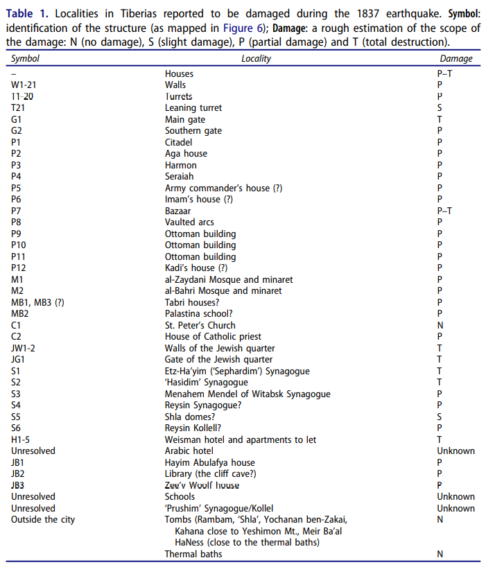 Table 1
Localities in Tiberias reported to be damaged during the 1837 earthquake.
- Symbol: identification of the structure (as mapped in Figure 6)
- Damage: a rough estimation of the scope of the damage
- N (no damage)
- S (slight damage)
- P (partial damage)
- T (total destruction)
Zohar (2017) - Fig. 6 Map of Tiberias
before the 1837 CE Safed Quake from Zohar (2017)
 Fig. 6
Tiberias and its major features prior to the 1837 earthquake (for notations see Table 1).
The city interior was compiled using pre-1837 drawings (Appendix 1), maps of Palestine (1938), PEF (1918), Burckhardt (1822) and historical accounts (Mariti 1791, Clarke 1810–1823, Light 1818, Turner 1820, Buckingham 1822, Richardson 1822, Scholz 1822, Wilson 1823, Carne 1826, Jowett 1826, Maden 1829, Madox 1834, Horne 1836, Stephens 1839, Kinglake 1848).
Zohar (2017) - Fig. 7 3D reconstruction
of Tiberias before and after the 1837 CE Safed Quake from Zohar (2017)
 Fig. 7
3D view of Tiberias
- Before the earthquake, superimposed on a topographic (DEM) surface
- after the earthquake overlain on a geological surface layer
- Al: Alluvium, colluvium, soil
- Nbg: Bira and Gesher formations
- Pβc: cover basalt
Prominent features (Table 1) are labelled in black. Note that the majority of Tiberias is located on basalt rocks and note the extensive damage along the fault that crosses the western walls.
Zohar (2017)
- Table 1 Localities reported
as damaged in 1837 CE Safed Quake and Legend/Key to sites in the Map in Figure 6 - from Zohar (2017)
Table 1
Localities in Tiberias reported to be damaged during the 1837 earthquake.
- Symbol: identification of the structure (as mapped in Figure 6)
- Damage: a rough estimation of the scope of the damage
- N (no damage)
- S (slight damage)
- P (partial damage)
- T (total destruction)
Zohar (2017) - Fig. 6 Map of Tiberias
before the 1837 CE Safed Quake from Zohar (2017)
Fig. 6
Tiberias and its major features prior to the 1837 earthquake (for notations see Table 1).
The city interior was compiled using pre-1837 drawings (Appendix 1), maps of Palestine (1938), PEF (1918), Burckhardt (1822) and historical accounts (Mariti 1791, Clarke 1810–1823, Light 1818, Turner 1820, Buckingham 1822, Richardson 1822, Scholz 1822, Wilson 1823, Carne 1826, Jowett 1826, Maden 1829, Madox 1834, Horne 1836, Stephens 1839, Kinglake 1848).
Zohar (2017) - Fig. 7 3D reconstruction
of Tiberias before and after the 1837 CE Safed Quake from Zohar (2017)
Fig. 7
3D view of Tiberias
- Before the earthquake, superimposed on a topographic (DEM) surface
- after the earthquake overlain on a geological surface layer
- Al: Alluvium, colluvium, soil
- Nbg: Bira and Gesher formations
- Pβc: cover basalt
Prominent features (Table 1) are labelled in black. Note that the majority of Tiberias is located on basalt rocks and note the extensive damage along the fault that crosses the western walls.
Zohar (2017)
Much of the sources divide their descriptions of the city by the existing ethnic groups at the time, i.e., Jews, Muslims and Christians. Along almost the entire nineteenth century each of these groups resided in a different and separated area within the city. Consequently, the reconstruction of the Tiberias cityscape and the following damage analyses was carried out in light of this sub-division of the city. A summary of the prominent structures, the reconstructed 2D map and the 3D models appear in Table 1, Figures 6 and 7, respectively.
At the beginning of the nineteenth century Tiberias was a desolated city situated on the western shores of the Sea of Galilee (Figure 6) (Volney 1788, Richardson 1822, Irby and Mangles 1823). Roughly, the city was divided into three quarters:
- the Muslims resided mainly at the northwestern area
- the Jews occupied an isolated quarter at the eastern side close to the shore
- several dozen Christians lived in the southern end of the city (Avissar 1973, Schur 1987, Ben-Yaakov 2001).
The city was surrounded by the mid-eighteenth century walls repaired by Dahir al-Umar and his son Chulaybi. Their thickness ranged between 80 and 120 cm and Birav (Bnayahu 1946) reported that they were so high that ladders were needed to climb over them. Other western travellers estimated their height between 6 and 8 m (Pococke 1745, Hasselquist 1766, Spilsbury 1823, Robinson and Smith 1856). The walls were flanked by 21 circular turrets standing at unequal distances between each other (Irby and Mangles 1823, Jowett 1826). According to Jacotin’s map and Burckhardt’s sketch, there were only two gates to the city: a western main gate and a small southern gate (Jacotin 1799, Burckhardt 1822). Like other Ottoman cities, the citadel on the northern hill of Tiberias protected the town from outer invasions (Pococke 1745, Hasselquist 1766, Clarke 1810– 1823).
There were two mosques in the city: the largest was the al-Zaydani (al-Umari), named after Dahir’s family name, while the other was al-Bahri (the sea mosque), and located south of the Jewish quarter. The Church of St. Peter was situated north of the Jewish quarter but the house of the Catholic priest, however, was at the southern end of the city.
Additional Ottoman buildings, located in the Muslim quarter close to the western gate, were the houses of the Aga (governor house or Seraiah), the Kadi, the Imam and the army commander (Schur 1987, Abbasi 2006) . A small bazaar decorated by massive vaults was located in the centre of the city. Other vaulted arches were located at the southern shoreline facing the sea (Burckhardt 1822).
The Jewish quarter occupied a portion of the city close to the shore. It was surrounded by a high wall with a western entrance gate, which was regularly shut at sunset. Apparently, there were at least two synagogues and a ‘Kolell’ (a Jewish school) within the quarter and probably another one at the southern end of the city: Stephens reported on two synagogues and two schools and Jowett reported on two schools and three synagogues. I assume that the ‘Kollell’ reported in 1833 in the letter of Rabbi Yaa’kov Menlis, is the ‘Reysin’ Kollell, located close to Menahem Mendel’s house (Stephens 1839, Jowett 1826, Robinson and Smith 1856, David Debith Hillel in Ya’ari 1976, pp. 512–514, Scholz 1822, de Gramb 1840, Schur 2002). Although Christians lived mainly in southern Tiberias, there were also a few dwellings of Jews there: von Puckler Muskau reported that a wealthy Jew (Hayim Weisman?) had 21 houses to let. He does not mention their exact location but since there are no reports of hotels in the Jewish quarter, I assume they were located in the southern part of the city (Pueckler-Muskau 1844). Located about half a kilometre south of the city were the Jewish and Muslim cemeteries and about one kilometre further south the thermal baths for local and touristic use (Seetzen 1810, Robinson and Smith 1841). North of the city there were several sacred tombs (Mendel 1839, Robinson and Smith 1856, Guerin 1880) and west of it a small agricultural area. One major road led to the city from the south and two others from the west (Jacotin 1799, Buckingham 1822, Olin 1844).
- Fig. F Main archaeological sites
of Tiberias from Cytryn-Silverman (2015)
 Figure F
Map of Tiberias, main archaeological sites
Prepared by Leticia Barda (Israel Antiquities Authority), adapted by Daniel Leviathan, The New Tiberias Excavation Project.
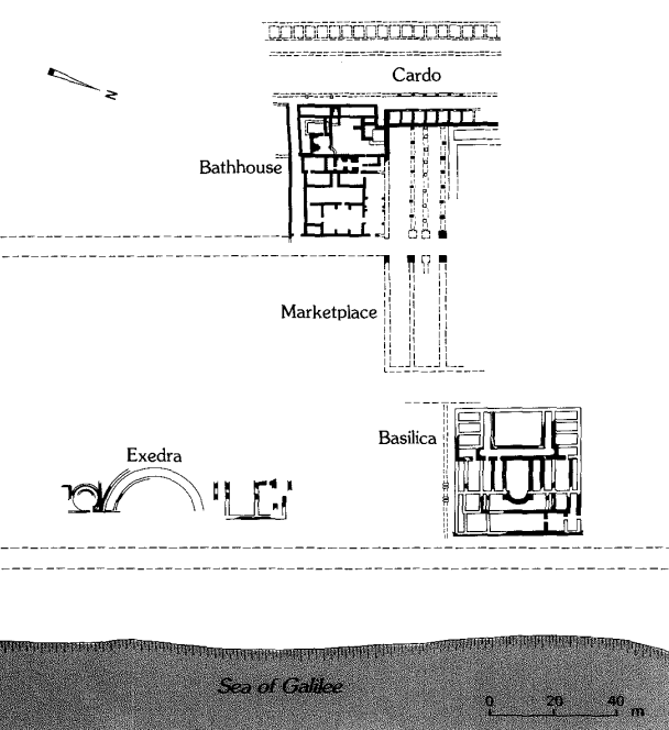
Cytryn-Silverman (2015) - Fig. 1 Map of Tiberias
during the Roman period from Atrash (2010)
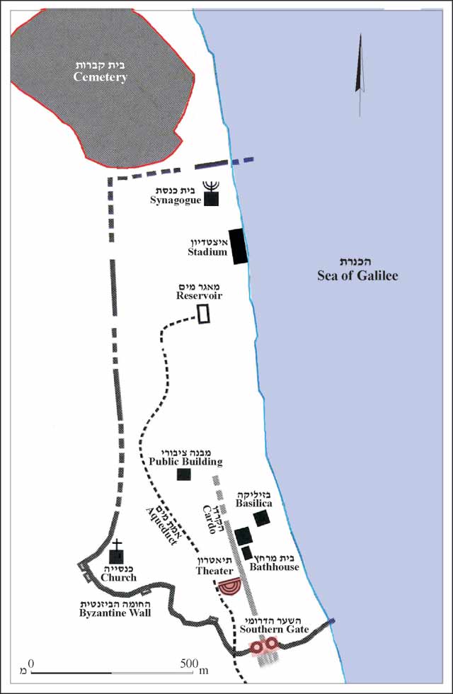 Figure 1. The city during the Roman period, plan (based on Hirschfeld 1992)
Atrash (2010) - City plan of Tiberias
from Stern et al (1993 v.4)
 Tiberias: city plan
Stern et al (1993 v.4) - City center plan of
Tiberias from Stern et al (1993 v.4)
 Plan of the main buildings in the city center. Plan of the main buildings in the city center
Stern et al (1993 v.4) - City gate from Roman period
Tiberias from Stern et al (1993 v.4)
 Area C: plan of the city gate from the Roman period and Early Arab period structures nearby
Stern et al (1993 v.4) - City Plan and wall
in the 6th century CE from Stern et al (1993 v.4)
 Tiberias: plan of the city and the city wall in the 6th century CE
Stern et al (1993 v.4)
- Fig. F Main archaeological sites
of Tiberias from Cytryn-Silverman (2015)
Figure F
Map of Tiberias, main archaeological sites
Prepared by Leticia Barda (Israel Antiquities Authority), adapted by Daniel Leviathan, The New Tiberias Excavation Project.
Cytryn-Silverman (2015) - Fig. 1 Map of Tiberias
during the Roman period from Atrash (2010)
Figure 1. The city during the Roman period, plan (based on Hirschfeld 1992)
Atrash (2010) - City plan of Tiberias
from Stern et al (1993 v.4)
Tiberias: city plan
Stern et al (1993 v.4) - City Plan and wall
in the 6th century CE from Stern et al (1993 v.4)
Tiberias: plan of the city and the city wall in the 6th century CE
Stern et al (1993 v.4)
- Fig. 1a Regional Damage
Distribution from the 1837 CE Safed Quake from Zohar (2017)
 Fig. 1a
Damage distribution in Ottoman Palestine and its close surroundings caused by the 1837 earthquake (Ambraseys 1997, 2009) and classified by the degree of severity (Zohar et al. 2013);
Zohar (2017) - Fig. 6 Map of Tiberias
before the 1837 CE Safed Quake from Zohar (2017)
Fig. 6
Tiberias and its major features prior to the 1837 earthquake (for notations see Table 1). The city interior was compiled using pre-1837 drawings (Appendix 1), maps of Palestine (1938), PEF (1918), Burckhardt (1822) and historical accounts (Mariti 1791, Clarke 1810–1823, Light 1818, Turner 1820, Buckingham 1822, Richardson 1822, Scholz 1822, Wilson 1823, Carne 1826, Jowett 1826, Maden 1829, Madox 1834, Horne 1836, Stephens 1839, Kinglake 1848).
Zohar (2017) - Fig. 8 Map of damage in
Tiberias due to 1837 CE Safed Quake from Zohar (2017)
 Fig. 8
The spread of the earthquake damage that resulted in Tiberias by comparing the two HGIS models of before and after the earthquake (Figure 7).
Zohar (2017)
- Fig. 1a Regional Damage
Distribution from the 1837 CE Safed Quake from Zohar (2017)
Fig. 1a
Damage distribution in Ottoman Palestine and its close surroundings caused by the 1837 earthquake (Ambraseys 1997, 2009) and classified by the degree of severity (Zohar et al. 2013);
Zohar (2017) - Fig. 6 Map of Tiberias
before the 1837 CE Safed Quake from Zohar (2017)
Fig. 6
Tiberias and its major features prior to the 1837 earthquake (for notations see Table 1). The city interior was compiled using pre-1837 drawings (Appendix 1), maps of Palestine (1938), PEF (1918), Burckhardt (1822) and historical accounts (Mariti 1791, Clarke 1810–1823, Light 1818, Turner 1820, Buckingham 1822, Richardson 1822, Scholz 1822, Wilson 1823, Carne 1826, Jowett 1826, Maden 1829, Madox 1834, Horne 1836, Stephens 1839, Kinglake 1848).
Zohar (2017) - Fig. 8 Map of damage in
Tiberias due to 1837 CE Safed Quake from Zohar (2017)
Fig. 8
The spread of the earthquake damage that resulted in Tiberias by comparing the two HGIS models of before and after the earthquake (Figure 7).
Zohar (2017)
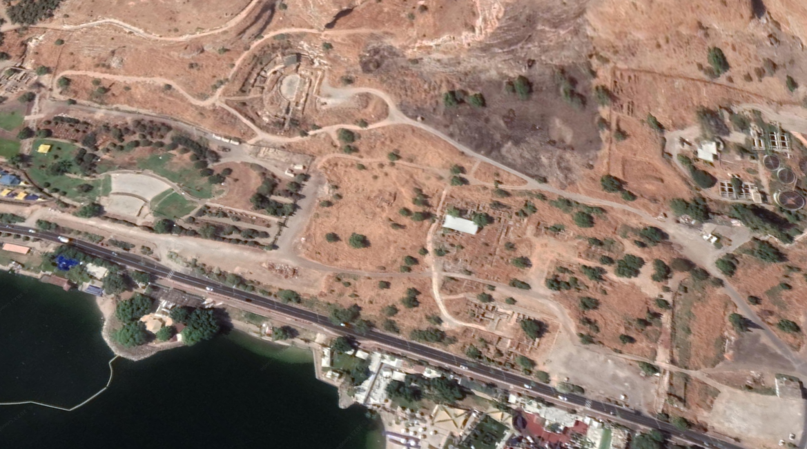
- Annotated Aerial View of
Tiberias from BibleWalks.com
- Fig. A - Aerial view of
ancient Tiberias from Cytryn-Silverman (2015)
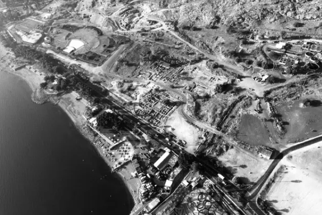 Figure A
Aerial view of ancient Tiberias, looking southwest
On the foreground remains of the basilical villa excavated by A. Druks and Y. Hirshfeld
To the west, the remains of the mosque and baths (under modern roof)
On the left, Berko Park with the remains of the Roman gate
On extreme right, Tiberias Sewage Treatment Plant, site of “The House of the Bronzes.”
Photo by David Silverman, The New Tiberias Excavation Project.
Cytryn-Silverman (2015) - Ancient Tiberias in Google Earth
Ancient Tiberias
click on image to explore this site on a new tab in Google Earth - Ancient Tiberias on govmap.gov.il
 Ancient Tiberias
click on image to explore this site on a new tab in govmap.gov.il

- Fig. 1b Satellite View of
the Old City of Tiberias from Zohar (2017)
 Fig. 1b
General overview of the old city of Tiberias.
Zohar (2017) - The "Old City" of Tiberias in Google Earth
 The "Old City" of Tiberias
click on image to explore this site on a new tab in Google Earth - The "Old City" of Tiberias on govmap.gov.il
 The "Old City" of Tiberias
click on image to explore this site on a new tab in govmap.gov.il
- Fig. 1b Satellite View of
the Old City of Tiberias from Zohar (2017)
Fig. 1b
General overview of the old city of Tiberias.
Zohar (2017)


- Fig. 4 Map of ancient Tiberias
with inferred fault from Ferrario et al (2020)
 Figure 4
Map of ancient Tiberias (modified after Hirschfeld & Gutfeld, 2008) with indication of the inferred lineament and trench position.
Ferrario et al (2020) - Fig. 1b Quaternary faults
around the Sea of Galilee and the Jordan Valley from Ferrario et al (2020)
 Figure 1b
Quaternary faults in the central part of the DSF, modified after Sneh and Weinberger (2014), Sagy et al. (2016), Hamiel et al. (2016), and Sharon et al. (2018, 2020); the red rectangle is the area enlarged in Fig. 1c
- JVWB: Jordan Valley Western Boundary Fault
- JVF: Jordan Valley Fault
- G: Gilboa Fault
Ferrario et al (2020) - Fig. 1c Simplified geologic map
around the Sea of Galilee along with epicenters of MW > 4.0 events since 1970 from Ferrario et al (2020)
 Figure 1c
Simplified geologic map (after Bogoch & Sneh, 2008; Sneh, 2008), epicenters of MW > 4.0 events since 1970 (data from http://seis.gii.co.il/en/earthquake/searchEQSRslt.php).
Ferrario et al (2020) - Fig. 10 Sketches of the shallow
subsurface from Ferrario et al (2020)
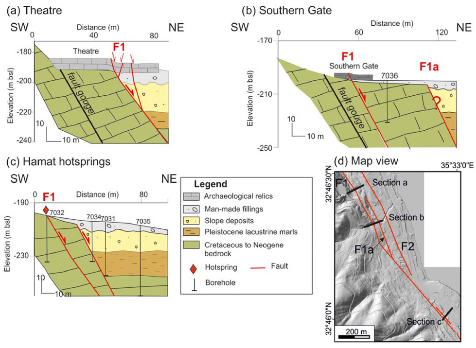 Figure 10
Schematic sketches of the shallow subsurface at three key positions
- Theater
- Southern Gate
- Hamat hot springs
- section traces
Information on geology is derived from the Israeli geological map (Sneh, 2008), published scientific literature (e.g., Hurwitz et al., 2002), and local reports (e.g., Zaslavsky, 2009). Borehole logs are from GSI archive
Ferrario et al (2020) - Fig. 2b Morphotectonic map
from Ferrario et al (2020)
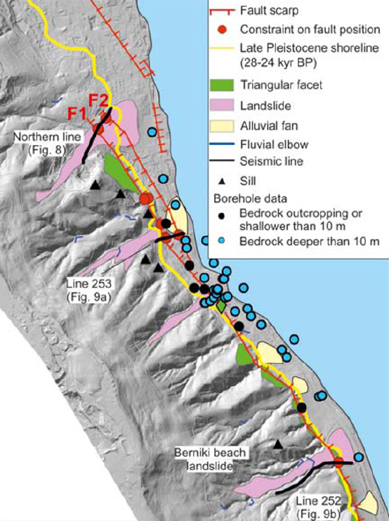 Figure 2b
morphotectonic map of the study area, based on 0.5 m resolution DTM extracted from airborne Lidar survey. The map shows also the late Pleistocene shoreline, the position of boreholes analyzed in this study, and the points where we constrained the spatial position of the fault trace.
Ferrario et al (2020) - Fig. 9 Interpreted Seismic
lines from Ferrario et al (2020)
 Figure 9
Seismic lines and relative interpretation
- Southern Gate, location of the trench is also shown
- Berniki Beach landslide
- Traces of the seismic lines
Ferrario et al (2020) - Fig. 8 Interpreted Seismic line
run north of Tiberias Theater from Ferrario et al (2020)
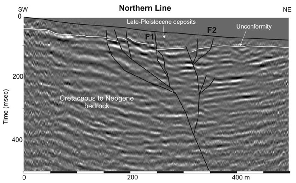 Figure 8
Seismic line run north of Tiberias Theater and relative interpretation; trace in Figure 9.
Ferrario et al (2020) - Fig. 2a Site Map
from Ferrario et al (2020)
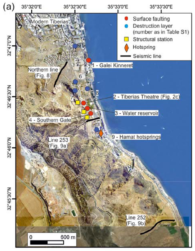 Figure 2a
Relevant sites mentioned in the text and location of the seismic lines; numbers correspond to Table S1 in the supporting information where relevant references are provided
Ferrario et al (2020)
- Fig. 1b Quaternary faults
around the Sea of Galilee and the Jordan Valley from Ferrario et al (2020)
Figure 1b
Quaternary faults in the central part of the DSF, modified after Sneh and Weinberger (2014), Sagy et al. (2016), Hamiel et al. (2016), and Sharon et al. (2018, 2020); the red rectangle is the area enlarged in Fig. 1c
- JVWB: Jordan Valley Western Boundary Fault
- JVF: Jordan Valley Fault
- G: Gilboa Fault
Ferrario et al (2020) - Fig. 2b Morphotectonic map
from Ferrario et al (2020)
Figure 2b
morphotectonic map of the study area, based on 0.5 m resolution DTM extracted from airborne Lidar survey. The map shows also the late Pleistocene shoreline, the position of boreholes analyzed in this study, and the points where we constrained the spatial position of the fault trace.
Ferrario et al (2020) - Fig. 9 Interpreted Seismic
lines from Ferrario et al (2020)
Figure 9
Seismic lines and relative interpretation
- Southern Gate, location of the trench is also shown
- Berniki Beach landslide
- Traces of the seismic lines
Ferrario et al (2020) - Fig. 8 Interpreted Seismic line
run north of Tiberias Theater from Ferrario et al (2020)
Figure 8
Seismic line run north of Tiberias Theater and relative interpretation; trace in Figure 9.
Ferrario et al (2020) - Fig. 2a Site Map
from Ferrario et al (2020)
Figure 2a
Relevant sites mentioned in the text and location of the seismic lines; numbers correspond to Table S1 in the supporting information where relevant references are provided
Ferrario et al (2020)
- from Zaslavsky et al. (2009a)
- Table 1 Stratigraphic
Table from Zaslavsky et al. (2009a)
 Table 1
Stratigraphic table of the geological map of Tiberias
(Sneh, 2008)
Zaslavsky et al. (2009a)
 Figure 2
Geological map of the study area compiled from Sneh (2008), and Bogoch and Sneh (2008) with an overlay of faults according to Schulman (1966), and with locations of the refraction profiles TB-1, TB-2 and TB-3 (Ezersky, 2008); R-1 and R-2 (Shtivelman, 1995) and profiles 1 and 2 for constructing cross sections.
Zaslavsky et al. (2009a)
Table 1Stratigraphic table of the geological map of Tiberias
(Sneh, 2008)
Zaslavsky et al. (2009a)
- Fig. 14 Proposed reconstruction
of the ancient city of Tiberias from Hirschfeld and Galor (2007) and Atrash (2012)
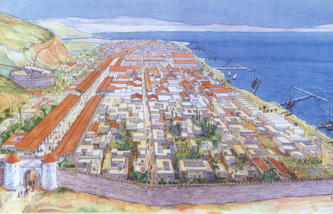 Figure 14
Proposed reconstruction of the ancient city of Tiberias, looking north
(drawn by Dov Porotzky)
Caption from Hirschfeld and Galor (2007) and image from Atrash (2012)
- Fig. E Roman cardo and
overlaying street from Cytryn-Silverman (2015)
 Figure E
Remains of Roman cardo and overlaying street of the Early Islamic street, leading to the mosque through a set of steps. On the left series of shops of the early Islamic period adjacent to the street exposed by B. Ravani in the 1950s
Photo by David Silverman, The New Tiberias Excavation Project.
Cytryn-Silverman (2015)
| Effect | Location | Image(s) | Description |
|---|---|---|---|
| Damaged and Tilted Walls | Citadel Walls (P1) and turrets (T4-T7)
Fig. 1b General overview of the old city of Tiberias. Zohar (2017)
Fig. 6Tiberias and its major features prior to the 1837 earthquake (for notations see Table 1). The city interior was compiled using pre-1837 drawings (Appendix 1), maps of Palestine (1938), PEF (1918), Burckhardt (1822) and historical accounts (Mariti 1791, Clarke 1810–1823, Light 1818, Turner 1820, Buckingham 1822, Richardson 1822, Scholz 1822, Wilson 1823, Carne 1826, Jowett 1826, Maden 1829, Madox 1834, Horne 1836, Stephens 1839, Kinglake 1848). Zohar (2017)
Table 1Localities in Tiberias reported to be damaged during the 1837 earthquake.
|
 Fig. 2b
the Citadel in Tiberias where 1837 earthquake damage is apparent. Photograph: Motti Zohar, 2015 Zohar (2017)  Fig. 16
1837: Tiberias after the earthquake drawn from the south. Note the damage to the citadel (P1), to the walls and to its turrets (T4‐T17). The Jewish quarter is depicted as partially destroyed while in the Muslim and Christian quarters there are hardly any standing dwellings. The drawing seems to be realistic: parts of the walls (e.g., W7b, W8a, and W16) and turrets (e.g., T8, T10 and T16) that were drawn as not destroyed still exist till today (Lehoux in de Laborde, 1837). Zohar (2017)  Fig. 19
. 1839a: Damage to the citadel and walls. Note the completeness of the Seraiah (P2) and the presence of the minaret of al-Zaydani mosque (M1) (Roberts, 1842-1849). Zohar (2017)  Fig. 20
1839b: Tiberias from the south. Note the arched vaults (P8), al-Zaydani mosque and minaret but no dome, the ruined citadel (P1), the Seraiah (P2), a Synagogue (Etz Hayim?, S1), turret T1 in the water, and St. Peter church (Roberts, 1842-1849). Zohar (2017)  Fig. 25
1841: Ruins of Tiberias. The citadel (P1) is depicted as slightly damaged (Munk, 1845). Zohar (2017)  Fig. 26
1842a: Tiberias and its citadel in a drawing drawn from the north (Bartlett in Stebbing, 1847). Note the similarity of T4 and T5 to their recent state (upper left corner) and the accuracy of the hatch (red square) as drawn by Bartlett Zohar (2017)  Fig. 30
1842e: sketch of Tiberias from the west. Large breaches appear in the western and southern walls of the city (Bartlett, 1850). Zohar (2017)  Fig. 35
1851-52: Tiberias from the south (Van de Velde, 1857). Zohar (2017) |
|
| Sheared Wall | Southern turret in Southern Wall
Fig. 1b General overview of the old city of Tiberias. Zohar (2017)
Fig. 6Tiberias and its major features prior to the 1837 earthquake (for notations see Table 1). The city interior was compiled using pre-1837 drawings (Appendix 1), maps of Palestine (1938), PEF (1918), Burckhardt (1822) and historical accounts (Mariti 1791, Clarke 1810–1823, Light 1818, Turner 1820, Buckingham 1822, Richardson 1822, Scholz 1822, Wilson 1823, Carne 1826, Jowett 1826, Maden 1829, Madox 1834, Horne 1836, Stephens 1839, Kinglake 1848). Zohar (2017)
Table 1Localities in Tiberias reported to be damaged during the 1837 earthquake.
|
 Fig. 2f
one of the southern damaged turrets in Tiberias’s walls. Photograph: Motti Zohar, 2015 Zohar (2017)  Sheared turret in Tiberias' southern Wall
Photo by Jefferson Williams on 11 June 2023  Fig. 38
1863: Tiberias from the western road leading to the main gate. Note the possible identification of turret T17 (Unknown, 1867). In my opinion the drawing was copied from Munk (1845). Zohar (2017) |
|
| Dome collapse | al-Zaydani Mosque (M1)
Fig. 1b General overview of the old city of Tiberias. Zohar (2017)
Fig. 6Tiberias and its major features prior to the 1837 earthquake (for notations see Table 1). The city interior was compiled using pre-1837 drawings (Appendix 1), maps of Palestine (1938), PEF (1918), Burckhardt (1822) and historical accounts (Mariti 1791, Clarke 1810–1823, Light 1818, Turner 1820, Buckingham 1822, Richardson 1822, Scholz 1822, Wilson 1823, Carne 1826, Jowett 1826, Maden 1829, Madox 1834, Horne 1836, Stephens 1839, Kinglake 1848). Zohar (2017)
Table 1Localities in Tiberias reported to be damaged during the 1837 earthquake.
|
 Fig. 2a
al-Zaydani Mosque in Tiberias. Photograph: Motti Zohar, 2015 Zohar (2017)  Fig. 4
1814: al-Zaydani mosque drawn from close range within the city itself (Light, 1818). Note the relatively large dome also present in other pre-1837 drawings (e.g., Buckingham, 1822; Marilhat in de Laborde, 1837; Wilson, 1823). Zohar (2017)
Fig. 161837: Tiberias after the earthquake drawn from the south. Note the damage to the citadel (P1), to the walls and to its turrets (T4‐T17). The Jewish quarter is depicted as partially destroyed while in the Muslim and Christian quarters there are hardly any standing dwellings. The drawing seems to be realistic: parts of the walls (e.g., W7b, W8a, and W16) and turrets (e.g., T8, T10 and T16) that were drawn as not destroyed still exist till today (Lehoux in de Laborde, 1837). Zohar (2017)
Fig. 19. 1839a: Damage to the citadel and walls. Note the completeness of the Seraiah (P2) and the presence of the minaret of al-Zaydani mosque (M1) (Roberts, 1842-1849). Zohar (2017)
Fig. 201839b: Tiberias from the south. Note the arched vaults (P8), al-Zaydani mosque and minaret but no dome, the ruined citadel (P1), the Seraiah (P2), a Synagogue (Etz Hayim?, S1), turret T1 in the water, and St. Peter church (Roberts, 1842-1849). Zohar (2017)  Fig. 22
1839d: The citadel (P1) is depicted partially ruined; the Seraiah (P2); the walls that are partially ruined, al-Zaydani mosque without a dome (Roberts, 1842-1849). Note turret T21 leaning towards the east and its lower supporting belt (noted by red arrow). Zohar (2017)
Fig. 251841: Ruins of Tiberias. The citadel (P1) is depicted as slightly damaged (Munk, 1845). Zohar (2017)  Fig. 32
1848: Tiberias from the north, probably drawn somewhere on the hill of the citadel (Lynch, 1849). Prominent features:
Zohar (2017)  Fig. 33
1849: the road from Safed leading to Tiberias, the citadel and the walls (Spencer, 1850). Zohar (2017)
Fig. 351851-52: Tiberias from the south (Van de Velde, 1857). Zohar (2017)  Fig. 39
c.1870: a photograph probably taken from the hill of the citadel (Bonfils, 1878?). The northern region was not populated. No minaret of al-Bahri mosque, no dome to al-Zaydani. Zohar (2017) |
|
| Minaret Collapse | al-Bahri Mosque (M2)
Fig. 1b General overview of the old city of Tiberias. Zohar (2017)
Fig. 6Tiberias and its major features prior to the 1837 earthquake (for notations see Table 1). The city interior was compiled using pre-1837 drawings (Appendix 1), maps of Palestine (1938), PEF (1918), Burckhardt (1822) and historical accounts (Mariti 1791, Clarke 1810–1823, Light 1818, Turner 1820, Buckingham 1822, Richardson 1822, Scholz 1822, Wilson 1823, Carne 1826, Jowett 1826, Maden 1829, Madox 1834, Horne 1836, Stephens 1839, Kinglake 1848). Zohar (2017)
Table 1Localities in Tiberias reported to be damaged during the 1837 earthquake.
|
 Fig. 2c
al-Bahri Mosque in Tiberias. Photograph: Motti Zohar, 2015 Zohar (2017)
Fig. 351851-52: Tiberias from the south (Van de Velde, 1857). Zohar (2017)
Fig. 39c.1870: a photograph probably taken from the hill of the citadel (Bonfils, 1878?). The northern region was not populated. No minaret of al-Bahri mosque, no dome to al-Zaydani. Zohar (2017) |
|
| Vault Destruction - completely or badly destroyed | Vaulted Bazaar (P7)
Fig. 6 Tiberias and its major features prior to the 1837 earthquake (for notations see Table 1). The city interior was compiled using pre-1837 drawings (Appendix 1), maps of Palestine (1938), PEF (1918), Burckhardt (1822) and historical accounts (Mariti 1791, Clarke 1810–1823, Light 1818, Turner 1820, Buckingham 1822, Richardson 1822, Scholz 1822, Wilson 1823, Carne 1826, Jowett 1826, Maden 1829, Madox 1834, Horne 1836, Stephens 1839, Kinglake 1848). Zohar (2017)
Table 1Localities in Tiberias reported to be damaged during the 1837 earthquake.
|
 Fig. 2d
remains of the massive vaults in southern Tiberias (noted by red arrow). Photograph: Motti Zohar, 2015 Zohar (2017) |
|
| Damaged Arches | Vaulted Arcs (P8)
Fig. 6 Tiberias and its major features prior to the 1837 earthquake (for notations see Table 1). The city interior was compiled using pre-1837 drawings (Appendix 1), maps of Palestine (1938), PEF (1918), Burckhardt (1822) and historical accounts (Mariti 1791, Clarke 1810–1823, Light 1818, Turner 1820, Buckingham 1822, Richardson 1822, Scholz 1822, Wilson 1823, Carne 1826, Jowett 1826, Maden 1829, Madox 1834, Horne 1836, Stephens 1839, Kinglake 1848). Zohar (2017)
Table 1Localities in Tiberias reported to be damaged during the 1837 earthquake.
|
Fig. 20 1839b: Tiberias from the south. Note the arched vaults (P8), al-Zaydani mosque and minaret but no dome, the ruined citadel (P1), the Seraiah (P2), a Synagogue (Etz Hayim?, S1), turret T1 in the water, and St. Peter church (Roberts, 1842-1849). Zohar (2017)  Fig. 45
1898-1914: (ACPD, 1898-1914b) Zohar (2017) |
|
| Collapsed Walls | dwellings
Fig. 6 Tiberias and its major features prior to the 1837 earthquake (for notations see Table 1). The city interior was compiled using pre-1837 drawings (Appendix 1), maps of Palestine (1938), PEF (1918), Burckhardt (1822) and historical accounts (Mariti 1791, Clarke 1810–1823, Light 1818, Turner 1820, Buckingham 1822, Richardson 1822, Scholz 1822, Wilson 1823, Carne 1826, Jowett 1826, Maden 1829, Madox 1834, Horne 1836, Stephens 1839, Kinglake 1848). Zohar (2017) |
Fig. 16 1837: Tiberias after the earthquake drawn from the south. Note the damage to the citadel (P1), to the walls and to its turrets (T4‐T17). The Jewish quarter is depicted as partially destroyed while in the Muslim and Christian quarters there are hardly any standing dwellings. The drawing seems to be realistic: parts of the walls (e.g., W7b, W8a, and W16) and turrets (e.g., T8, T10 and T16) that were drawn as not destroyed still exist till today (Lehoux in de Laborde, 1837). Zohar (2017) |
|
| Damaged Walls | City Walls (W1-21)
Fig. 6 Tiberias and its major features prior to the 1837 earthquake (for notations see Table 1). The city interior was compiled using pre-1837 drawings (Appendix 1), maps of Palestine (1938), PEF (1918), Burckhardt (1822) and historical accounts (Mariti 1791, Clarke 1810–1823, Light 1818, Turner 1820, Buckingham 1822, Richardson 1822, Scholz 1822, Wilson 1823, Carne 1826, Jowett 1826, Maden 1829, Madox 1834, Horne 1836, Stephens 1839, Kinglake 1848). Zohar (2017) |
 Fig. 7
1828: Tiberias from the south in the book of Leon de Laborde. The latter visited Palestine in 1828 but his book on Syria, Lebanon and Palestine was published only in 1837. The book contains also other artist’s drawings. This drawing was drawn by Marilhat and considered realistic. For example, the number of turrets and location of the citadel are accurate in light of our current knowledge of the Tiberias morphology (Marilhat in de Laborde, 1837) Zohar (2017)  Fig. 15
Prior to 1837: Tiberias from the south (Leitch & Foster, 1855). In my opinion, this is probably a copy of the sketch after Marilhat (de Laborde, 1837). Zohar (2017)  Fig. 17
Before 1837: The drawing portrays Tiberias prior to the earthquake but the date of painting is unresolved. It appears only in the 5th edition of Lindsay (1858). Lindsay visited Palestine twice and only after the earthquake (1837 and 1847) and thus, in my opinion, the drawing is a copy of a previous one, perhaps of Lehoux (de Laborde, 1837) Zohar (2017)
Fig. 351851-52: Tiberias from the south (Van de Velde, 1857). Zohar (2017)
Fig. 161837: Tiberias after the earthquake drawn from the south. Note the damage to the citadel (P1), to the walls and to its turrets (T4‐T17). The Jewish quarter is depicted as partially destroyed while in the Muslim and Christian quarters there are hardly any standing dwellings. The drawing seems to be realistic: parts of the walls (e.g., W7b, W8a, and W16) and turrets (e.g., T8, T10 and T16) that were drawn as not destroyed still exist till today (Lehoux in de Laborde, 1837). Zohar (2017) |
|
| Damaged Walls | Turrets (T1-20)
Fig. 6 Tiberias and its major features prior to the 1837 earthquake (for notations see Table 1). The city interior was compiled using pre-1837 drawings (Appendix 1), maps of Palestine (1938), PEF (1918), Burckhardt (1822) and historical accounts (Mariti 1791, Clarke 1810–1823, Light 1818, Turner 1820, Buckingham 1822, Richardson 1822, Scholz 1822, Wilson 1823, Carne 1826, Jowett 1826, Maden 1829, Madox 1834, Horne 1836, Stephens 1839, Kinglake 1848). Zohar (2017) |
|
|
| Tilted Wall | Leaning Turret (T21)
Fig. 6 Tiberias and its major features prior to the 1837 earthquake (for notations see Table 1). The city interior was compiled using pre-1837 drawings (Appendix 1), maps of Palestine (1938), PEF (1918), Burckhardt (1822) and historical accounts (Mariti 1791, Clarke 1810–1823, Light 1818, Turner 1820, Buckingham 1822, Richardson 1822, Scholz 1822, Wilson 1823, Carne 1826, Jowett 1826, Maden 1829, Madox 1834, Horne 1836, Stephens 1839, Kinglake 1848). Zohar (2017) |
 Fig. 31
1842f: the leaning turret (T21) and the citadel (P1) (Bartlett, 1850). Zohar (2017)
Fig. 221839d: The citadel (P1) is depicted partially ruined; the Seraiah (P2); the walls that are partially ruined, al-Zaydani mosque without a dome (Roberts, 1842-1849). Note turret T21 leaning towards the east and its lower supporting belt (noted by red arrow). Zohar (2017) |
|
| Collapsed Wall | Main Gate (G1)
Fig. 6 Tiberias and its major features prior to the 1837 earthquake (for notations see Table 1). The city interior was compiled using pre-1837 drawings (Appendix 1), maps of Palestine (1938), PEF (1918), Burckhardt (1822) and historical accounts (Mariti 1791, Clarke 1810–1823, Light 1818, Turner 1820, Buckingham 1822, Richardson 1822, Scholz 1822, Wilson 1823, Carne 1826, Jowett 1826, Maden 1829, Madox 1834, Horne 1836, Stephens 1839, Kinglake 1848). Zohar (2017) |
 Fig. 11
1835: The town from the north. Note the turrets and the two minarets of al-Zaydani and al-Bahri mosques (Harding, 1835). The drawing was probably copied from the drawing of Marilhat (in de Laborde, 1837). Zohar (2017) 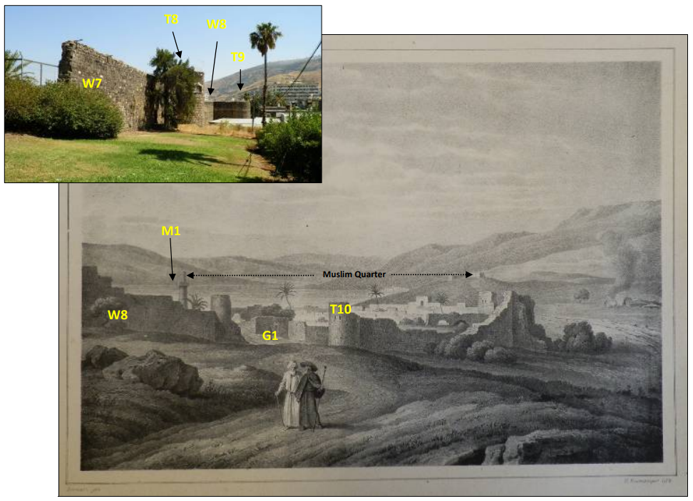 Fig. 18
1837: Tiberias from the north, after the voyage of Bernatz and Schubert (Bernatz & Schubert, 1839). The drawing seems to be realistic as prominent features (e.g., W8 and T10) are depicted in similar shape and size as they are today. JW: Gate G1 is 'missing' Zohar (2017) |
|
| Damaged Walls | Southern Gate (G2)
Fig. 6 Tiberias and its major features prior to the 1837 earthquake (for notations see Table 1). The city interior was compiled using pre-1837 drawings (Appendix 1), maps of Palestine (1938), PEF (1918), Burckhardt (1822) and historical accounts (Mariti 1791, Clarke 1810–1823, Light 1818, Turner 1820, Buckingham 1822, Richardson 1822, Scholz 1822, Wilson 1823, Carne 1826, Jowett 1826, Maden 1829, Madox 1834, Horne 1836, Stephens 1839, Kinglake 1848). Zohar (2017) |
Fig. 7 1828: Tiberias from the south in the book of Leon de Laborde. The latter visited Palestine in 1828 but his book on Syria, Lebanon and Palestine was published only in 1837. The book contains also other artist’s drawings. This drawing was drawn by Marilhat and considered realistic. For example, the number of turrets and location of the citadel are accurate in light of our current knowledge of the Tiberias morphology (Marilhat in de Laborde, 1837) Zohar (2017) |
|
| Collapsed Walls | Walls of the Jewish Quarter (JW1-2)
Fig. 6 Tiberias and its major features prior to the 1837 earthquake (for notations see Table 1). The city interior was compiled using pre-1837 drawings (Appendix 1), maps of Palestine (1938), PEF (1918), Burckhardt (1822) and historical accounts (Mariti 1791, Clarke 1810–1823, Light 1818, Turner 1820, Buckingham 1822, Richardson 1822, Scholz 1822, Wilson 1823, Carne 1826, Jowett 1826, Maden 1829, Madox 1834, Horne 1836, Stephens 1839, Kinglake 1848). Zohar (2017) |
|
|
| Collapsed Walls | Gate of the Jewish Quarter (JG1)
Fig. 6 Tiberias and its major features prior to the 1837 earthquake (for notations see Table 1). The city interior was compiled using pre-1837 drawings (Appendix 1), maps of Palestine (1938), PEF (1918), Burckhardt (1822) and historical accounts (Mariti 1791, Clarke 1810–1823, Light 1818, Turner 1820, Buckingham 1822, Richardson 1822, Scholz 1822, Wilson 1823, Carne 1826, Jowett 1826, Maden 1829, Madox 1834, Horne 1836, Stephens 1839, Kinglake 1848). Zohar (2017) |
|
|
| Collapsed Walls | Etz-Ha'yim ('Sephardim') Synagogue (S1)
Fig. 6 Tiberias and its major features prior to the 1837 earthquake (for notations see Table 1). The city interior was compiled using pre-1837 drawings (Appendix 1), maps of Palestine (1938), PEF (1918), Burckhardt (1822) and historical accounts (Mariti 1791, Clarke 1810–1823, Light 1818, Turner 1820, Buckingham 1822, Richardson 1822, Scholz 1822, Wilson 1823, Carne 1826, Jowett 1826, Maden 1829, Madox 1834, Horne 1836, Stephens 1839, Kinglake 1848). Zohar (2017) |
 Fig. 2e
Etz-Hay’im Synagogue in Tiberias. Photograph: Motti Zohar, 2015 Zohar (2017) |
|
| Collapsed Walls | Hasidim' Synagogue (S2)
Fig. 6 Tiberias and its major features prior to the 1837 earthquake (for notations see Table 1). The city interior was compiled using pre-1837 drawings (Appendix 1), maps of Palestine (1938), PEF (1918), Burckhardt (1822) and historical accounts (Mariti 1791, Clarke 1810–1823, Light 1818, Turner 1820, Buckingham 1822, Richardson 1822, Scholz 1822, Wilson 1823, Carne 1826, Jowett 1826, Maden 1829, Madox 1834, Horne 1836, Stephens 1839, Kinglake 1848). Zohar (2017) |
|
|
| Casualties | Tiberias
Fig. 6 Tiberias and its major features prior to the 1837 earthquake (for notations see Table 1). The city interior was compiled using pre-1837 drawings (Appendix 1), maps of Palestine (1938), PEF (1918), Burckhardt (1822) and historical accounts (Mariti 1791, Clarke 1810–1823, Light 1818, Turner 1820, Buckingham 1822, Richardson 1822, Scholz 1822, Wilson 1823, Carne 1826, Jowett 1826, Maden 1829, Madox 1834, Horne 1836, Stephens 1839, Kinglake 1848). Zohar (2017) |
Fig. 16 1837: Tiberias after the earthquake drawn from the south. Note the damage to the citadel (P1), to the walls and to its turrets (T4‐T17). The Jewish quarter is depicted as partially destroyed while in the Muslim and Christian quarters there are hardly any standing dwellings. The drawing seems to be realistic: parts of the walls (e.g., W7b, W8a, and W16) and turrets (e.g., T8, T10 and T16) that were drawn as not destroyed still exist till today (Lehoux in de Laborde, 1837). Zohar (2017) |
|
- Table 1 from Zohar (2017)
Table 1Localities in Tiberias reported to be damaged during the 1837 earthquake.
- Symbol: identification of the structure (as mapped in Figure 6)
- Damage: a rough estimation of the scope of the damage
- N (no damage)
- S (slight damage)
- P (partial damage)
- T (total destruction)
Zohar (2017)
- Table 2 from Zohar (2017)
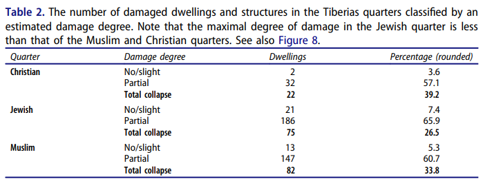 Table 2
The number of damaged dwellings and structures in the Tiberias quarters classified by an estimated damage degree. Note that the maximal degree of damage in the Jewish quarter is less than that of the Muslim and Christian quarters. See also Figure 8.
Zohar (2017)
- from Zohar (2017:13-15)
| Image | Figure | Description | Source |
|---|---|---|---|
|
Fig. 2a al-Zaydani Mosque in Tiberias. Photograph: Motti Zohar, 2015 Zohar (2017) |
Figure 2a | al-Zaydani Mosque in Tiberias | Zohar (2017) |
|
Fig. 2b the Citadel in Tiberias where 1837 earthquake damage is apparent. Photograph: Motti Zohar, 2015 Zohar (2017) |
Figure 2b | the Citadel in Tiberias where 1837 earthquake damage is apparent |
Zohar (2017) |
|
Fig. 2c al-Bahri Mosque in Tiberias. Photograph: Motti Zohar, 2015 Zohar (2017) |
Figure 2c | al-Bahri Mosque in Tiberias | Zohar (2017) |
|
Fig. 2d remains of the massive vaults in southern Tiberias (noted by red arrow). Photograph: Motti Zohar, 2015 Zohar (2017) |
Figure 2d | remains of the massive vaults in southern Tiberias (noted by red arrow) |
Zohar (2017) |
|
Fig. 2e Etz-Hay’im Synagogue in Tiberias. Photograph: Motti Zohar, 2015 Zohar (2017) |
Figure 2e | Etz-Hay’im Synagogue in Tiberias | Zohar (2017) |
|
Fig. 2f one of the southern damaged turrets in Tiberias’s walls. Photograph: Motti Zohar, 2015 Zohar (2017) |
Figure 2f | one of the southern damaged turrets in Tiberias’s walls where 1837 earthquake damage is apparent |
Zohar (2017) |
|
Table 1 Localities in Tiberias reported to be damaged during the 1837 earthquake.
Zohar (2017) |
Table 1 | Damage Table | Zohar (2017) |
|
Table 2 The number of damaged dwellings and structures in the Tiberias quarters classified by an estimated damage degree. Note that the maximal degree of damage in the Jewish quarter is less than that of the Muslim and Christian quarters. See also Figure 8. Zohar (2017) |
Table 2 | Damage in the Quarters | Zohar (2017) |
|
Fig. 6 Tiberias and its major features prior to the 1837 earthquake (for notations see Table 1). The city interior was compiled using pre-1837 drawings (Appendix 1), maps of Palestine (1938), PEF (1918), Burckhardt (1822) and historical accounts (Mariti 1791, Clarke 1810–1823, Light 1818, Turner 1820, Buckingham 1822, Richardson 1822, Scholz 1822, Wilson 1823, Carne 1826, Jowett 1826, Maden 1829, Madox 1834, Horne 1836, Stephens 1839, Kinglake 1848). Zohar (2017) |
Figure 6 | Tiberias before the 1837 CE Safed Quake | Zohar (2017) |
|
Fig. 7 3D view of Tiberias
Zohar (2017) |
Figure 7 | 3D reconstruction of Tiberias before and after the 1837 CE Safed Quake |
Zohar (2017) |
|
Fig. 8 The spread of the earthquake damage that resulted in Tiberias by comparing the two HGIS models of before and after the earthquake (Figure 7). Zohar (2017) |
Figure 8 | Map of damage in Tiberias due to 1837 CE Safed Quake | Zohar (2017) |
Rotating the models enabled a 360° examination of damage from almost any direction, even from spots that were not covered by the nineteenth century artists, such as an eastern spot in the Sea of Galilee or aerial views. The two models of before and after the earthquakes were compared (Figure 7) in order to identify the structural damage and examine its spread (Figure 8). It seems that although the Tiberias area was relatively small, the spread of the damage as well as its severity was not uniform. This is clearly observed particularly along the walls and between the residential quarters of the city. In general, such variability in damage within a small area may imply different local site attributes, whereas the distance from the epicentre and the directivity effect are almost identical in any spot within that area. Among the most influencing site attributes, one can count the construction quality, surface geology and topography (Zaslavsky et al. 2000). The latter two can hardly explain the differences whereas almost the whole of Tiberias is situated on basalt rocks (Pβc) and apart from the moderate northern slopes, the city lies on a flat plain (Figures. 7(a,b)). The construction quality, however, varies and manifests several structural styles for residential dwellings, religious structures and government buildings (Figure 2). Unfortunately, at this stage there is no reasonable understanding of the vulnerability and resistance of these structures to earthquake shaking. Yet, it is still possible to classify Tiberias’s structures into two groups.
- The first, which was probably more resistant to earthquake shaking, includes the Citadel, walls, turrets and government buildings such as the Seraiah and Kadi houses Most of them, although badly damaged, remained partially standing, even in cases where they were located on a hill in the north of the city. This is, of course, no surprise for these structures were built in advance to withstand outer attacks and thus were probably quite stable. Yet, there is a prominent exception that deserves attention: The western part of the walls (between turrets T-12 and T-16), although built of the same materials and quality as the rest of the walls, collapsed completely, while the northern part, built on a slope, was only slightly damaged. Figure 8 portrays the spread of the damage in relation to the surface geology and suspected active faults. Accordingly, the majority of Tiberias is located on a single geologic foundation of basalt rocks but close to the western walls, there is a fault. This fault, suspected to be active (Sagy et al. 2013), crosses the southern walls between T16–T17 and runs parallel to the western walls for about 200 m within the proximity of only 50 m. In addition, the fault runs in between the basalt and alluvium lithologies and perhaps this transition zone contributed to the increase of the damage. However, further site-specific investigation, which is beyond the scope of this study, is needed to verify the mechanical role of this fault and the lithological contrast in the stability of the western walls and the nearby structures.
- The second group includes dwellings and residential houses, most of which were completely damaged beyond repair. The damage in this category varies. The Jewish quarter seems to be slightly less damaged than the other quarters (Table 2) although the number of Jewish victims was greater (Robinson and Smith 1841). The explanation for this contradiction is not clear at this stage. Located along the shores of the lake, the Jewish quarter was more populated and clustered than the others and thus the dwellings in it were most likely of different architectural styles. In addition, a large part of the Muslim quarter in the north end of the city was located on a sloped hill whereas the Jewish and Christian quarters were located on a plain surface (Figure 7(a)). Thus, these factors also may have influenced the resistance to damage, but until the Ottoman construction styles are fully characterized, resolving this damage differentiation is rather complex.
- from Fig. 8 of Zohar (2017)
Fig. 8The spread of the earthquake damage that resulted in Tiberias by comparing the two HGIS models of before and after the earthquake (Figure 7).
Zohar (2017)
- Earthquake Archeological
Effects from Rodríguez-Pascua et al (2013: 221-224)
 Earthquake Archeological
Effects Chart
Earthquake Archeological
Effects Chart
Click on image to open in a new tab
Rodríguez-Pascua et al (2013)
| Effect | Location | Image(s) | Description(s) | Intensity |
|---|---|---|---|---|
|
Tiberias |
|
|
- Earthquake Archeological
Effects from Rodríguez-Pascua et al (2013: 221-224)
Earthquake Archeological
Effects Chart
Click on image to open in a new tab
Rodríguez-Pascua et al (2013) - Simple MMI Intensity Scale
 Simple MMI Intensity
Scale
Simple MMI Intensity
Scale
Click on image to open in a new tab - More Subjective MMI Intensity Scale
 More Subjective MMI Scale
Click on image to open in a new tab
| Effect | Location | Image(s) | Description(s) | Intensity |
|---|---|---|---|---|
|
Tiberias |
|
|
- Earthquake Archeological
Effects from Rodríguez-Pascua et al (2013: 221-224)
Earthquake Archeological
Effects Chart
Click on image to open in a new tab
Rodríguez-Pascua et al (2013) - Environmental Effects (ESI 2007)
 Graphic Representation of
ESI 2007 Intensity
Graphic Representation of
ESI 2007 Intensity
Click on image to open in a new tab
- Synoptic Table of ESI 2007
Intensity Degrees from Michetti et al. (2007)
 Synoptic Table of ESI 2007
Intensity Degrees
Synoptic Table of ESI 2007
Intensity Degrees
Accuracy improves in higher degrees, especially VIII–XII.
Click on image to open in a new tab
Michetti et al. (2007) - Environmental Effects vs. Intensity
from Michetti et al. (2007)
 Diagnostic ranges for
environmental effects by intensity
Diagnostic ranges for
environmental effects by intensity
Click on image to open in a new tab
Michetti et al. (2007) - Simple MMI Intensity Scale
Simple MMI Intensity
Scale
Click on image to open in a new tab - More Subjective MMI Intensity Scale
More Subjective MMI Scale
Click on image to open in a new tab

| Effect | Location | Image(s) | Description(s) | Intensity |
|---|---|---|---|---|
|
Tiberias |
|
|
- Earthquake Archeological
Effects from Rodríguez-Pascua et al (2013: 221-224)
Earthquake Archeological
Effects Chart
Click on image to open in a new tab
Rodríguez-Pascua et al (2013)
| Effect | Location | Image(s) | Description(s) | Intensity |
|---|---|---|---|---|
|
Tiberias |
|
|
- Earthquake Archeological Effects chart
of Rodríguez-Pascua et al (2013: 221-224)
 Earthquake Archeological Effects (EAE)
Rodríguez-Pascua et al (2013: 221-224)
| Effect | Location | Image(s) | Description | Intensity |
|---|---|---|---|---|
| Damaged and Tilted Walls | Citadel Walls (P1) and turrets (T4-T7)
Fig. 1b General overview of the old city of Tiberias. Zohar (2017)
Fig. 6Tiberias and its major features prior to the 1837 earthquake (for notations see Table 1). The city interior was compiled using pre-1837 drawings (Appendix 1), maps of Palestine (1938), PEF (1918), Burckhardt (1822) and historical accounts (Mariti 1791, Clarke 1810–1823, Light 1818, Turner 1820, Buckingham 1822, Richardson 1822, Scholz 1822, Wilson 1823, Carne 1826, Jowett 1826, Maden 1829, Madox 1834, Horne 1836, Stephens 1839, Kinglake 1848). Zohar (2017)
Table 1Localities in Tiberias reported to be damaged during the 1837 earthquake.
|
Fig. 2b the Citadel in Tiberias where 1837 earthquake damage is apparent. Photograph: Motti Zohar, 2015 Zohar (2017)
Fig. 161837: Tiberias after the earthquake drawn from the south. Note the damage to the citadel (P1), to the walls and to its turrets (T4‐T17). The Jewish quarter is depicted as partially destroyed while in the Muslim and Christian quarters there are hardly any standing dwellings. The drawing seems to be realistic: parts of the walls (e.g., W7b, W8a, and W16) and turrets (e.g., T8, T10 and T16) that were drawn as not destroyed still exist till today (Lehoux in de Laborde, 1837). Zohar (2017)
Fig. 19. 1839a: Damage to the citadel and walls. Note the completeness of the Seraiah (P2) and the presence of the minaret of al-Zaydani mosque (M1) (Roberts, 1842-1849). Zohar (2017)
Fig. 201839b: Tiberias from the south. Note the arched vaults (P8), al-Zaydani mosque and minaret but no dome, the ruined citadel (P1), the Seraiah (P2), a Synagogue (Etz Hayim?, S1), turret T1 in the water, and St. Peter church (Roberts, 1842-1849). Zohar (2017)
Fig. 251841: Ruins of Tiberias. The citadel (P1) is depicted as slightly damaged (Munk, 1845). Zohar (2017)
Fig. 261842a: Tiberias and its citadel in a drawing drawn from the north (Bartlett in Stebbing, 1847). Note the similarity of T4 and T5 to their recent state (upper left corner) and the accuracy of the hatch (red square) as drawn by Bartlett Zohar (2017)
Fig. 301842e: sketch of Tiberias from the west. Large breaches appear in the western and southern walls of the city (Bartlett, 1850). Zohar (2017)
Fig. 351851-52: Tiberias from the south (Van de Velde, 1857). Zohar (2017) |
|
VII + |
| Sheared Wall | Southern turret in Southern Wall
Fig. 1b General overview of the old city of Tiberias. Zohar (2017)
Fig. 6Tiberias and its major features prior to the 1837 earthquake (for notations see Table 1). The city interior was compiled using pre-1837 drawings (Appendix 1), maps of Palestine (1938), PEF (1918), Burckhardt (1822) and historical accounts (Mariti 1791, Clarke 1810–1823, Light 1818, Turner 1820, Buckingham 1822, Richardson 1822, Scholz 1822, Wilson 1823, Carne 1826, Jowett 1826, Maden 1829, Madox 1834, Horne 1836, Stephens 1839, Kinglake 1848). Zohar (2017)
Table 1Localities in Tiberias reported to be damaged during the 1837 earthquake.
|
Fig. 2f one of the southern damaged turrets in Tiberias’s walls. Photograph: Motti Zohar, 2015 Zohar (2017)
Sheared turret in Tiberias' southern WallPhoto by Jefferson Williams on 11 June 2023
Fig. 381863: Tiberias from the western road leading to the main gate. Note the possible identification of turret T17 (Unknown, 1867). In my opinion the drawing was copied from Munk (1845). Zohar (2017) |
VIII + | |
| Dome collapse | al-Zaydani Mosque (M1)
Fig. 1b General overview of the old city of Tiberias. Zohar (2017)
Fig. 6Tiberias and its major features prior to the 1837 earthquake (for notations see Table 1). The city interior was compiled using pre-1837 drawings (Appendix 1), maps of Palestine (1938), PEF (1918), Burckhardt (1822) and historical accounts (Mariti 1791, Clarke 1810–1823, Light 1818, Turner 1820, Buckingham 1822, Richardson 1822, Scholz 1822, Wilson 1823, Carne 1826, Jowett 1826, Maden 1829, Madox 1834, Horne 1836, Stephens 1839, Kinglake 1848). Zohar (2017)
Table 1Localities in Tiberias reported to be damaged during the 1837 earthquake.
|
Fig. 2a al-Zaydani Mosque in Tiberias. Photograph: Motti Zohar, 2015 Zohar (2017)
Fig. 41814: al-Zaydani mosque drawn from close range within the city itself (Light, 1818). Note the relatively large dome also present in other pre-1837 drawings (e.g., Buckingham, 1822; Marilhat in de Laborde, 1837; Wilson, 1823). Zohar (2017)
Fig. 161837: Tiberias after the earthquake drawn from the south. Note the damage to the citadel (P1), to the walls and to its turrets (T4‐T17). The Jewish quarter is depicted as partially destroyed while in the Muslim and Christian quarters there are hardly any standing dwellings. The drawing seems to be realistic: parts of the walls (e.g., W7b, W8a, and W16) and turrets (e.g., T8, T10 and T16) that were drawn as not destroyed still exist till today (Lehoux in de Laborde, 1837). Zohar (2017)
Fig. 19. 1839a: Damage to the citadel and walls. Note the completeness of the Seraiah (P2) and the presence of the minaret of al-Zaydani mosque (M1) (Roberts, 1842-1849). Zohar (2017)
Fig. 201839b: Tiberias from the south. Note the arched vaults (P8), al-Zaydani mosque and minaret but no dome, the ruined citadel (P1), the Seraiah (P2), a Synagogue (Etz Hayim?, S1), turret T1 in the water, and St. Peter church (Roberts, 1842-1849). Zohar (2017)
Fig. 221839d: The citadel (P1) is depicted partially ruined; the Seraiah (P2); the walls that are partially ruined, al-Zaydani mosque without a dome (Roberts, 1842-1849). Note turret T21 leaning towards the east and its lower supporting belt (noted by red arrow). Zohar (2017)
Fig. 251841: Ruins of Tiberias. The citadel (P1) is depicted as slightly damaged (Munk, 1845). Zohar (2017)
Fig. 321848: Tiberias from the north, probably drawn somewhere on the hill of the citadel (Lynch, 1849). Prominent features:
Zohar (2017)
Fig. 331849: the road from Safed leading to Tiberias, the citadel and the walls (Spencer, 1850). Zohar (2017)
Fig. 351851-52: Tiberias from the south (Van de Velde, 1857). Zohar (2017)
Fig. 39c.1870: a photograph probably taken from the hill of the citadel (Bonfils, 1878?). The northern region was not populated. No minaret of al-Bahri mosque, no dome to al-Zaydani. Zohar (2017) |
|
VIII + |
| Minaret Collapse | al-Bahri Mosque (M2)
Fig. 1b General overview of the old city of Tiberias. Zohar (2017)
Fig. 6Tiberias and its major features prior to the 1837 earthquake (for notations see Table 1). The city interior was compiled using pre-1837 drawings (Appendix 1), maps of Palestine (1938), PEF (1918), Burckhardt (1822) and historical accounts (Mariti 1791, Clarke 1810–1823, Light 1818, Turner 1820, Buckingham 1822, Richardson 1822, Scholz 1822, Wilson 1823, Carne 1826, Jowett 1826, Maden 1829, Madox 1834, Horne 1836, Stephens 1839, Kinglake 1848). Zohar (2017)
Table 1Localities in Tiberias reported to be damaged during the 1837 earthquake.
|
Fig. 2c al-Bahri Mosque in Tiberias. Photograph: Motti Zohar, 2015 Zohar (2017)
Fig. 351851-52: Tiberias from the south (Van de Velde, 1857). Zohar (2017)
Fig. 39c.1870: a photograph probably taken from the hill of the citadel (Bonfils, 1878?). The northern region was not populated. No minaret of al-Bahri mosque, no dome to al-Zaydani. Zohar (2017) |
|
VI-VII + |
| Vault Destruction - completely or badly destroyed | Vaulted Bazaar (P7)
Fig. 6 Tiberias and its major features prior to the 1837 earthquake (for notations see Table 1). The city interior was compiled using pre-1837 drawings (Appendix 1), maps of Palestine (1938), PEF (1918), Burckhardt (1822) and historical accounts (Mariti 1791, Clarke 1810–1823, Light 1818, Turner 1820, Buckingham 1822, Richardson 1822, Scholz 1822, Wilson 1823, Carne 1826, Jowett 1826, Maden 1829, Madox 1834, Horne 1836, Stephens 1839, Kinglake 1848). Zohar (2017)
Table 1Localities in Tiberias reported to be damaged during the 1837 earthquake.
|
Fig. 2d remains of the massive vaults in southern Tiberias (noted by red arrow). Photograph: Motti Zohar, 2015 Zohar (2017) |
|
VIII + |
| Damaged Arches | Vaulted Arcs (P8)
Fig. 6 Tiberias and its major features prior to the 1837 earthquake (for notations see Table 1). The city interior was compiled using pre-1837 drawings (Appendix 1), maps of Palestine (1938), PEF (1918), Burckhardt (1822) and historical accounts (Mariti 1791, Clarke 1810–1823, Light 1818, Turner 1820, Buckingham 1822, Richardson 1822, Scholz 1822, Wilson 1823, Carne 1826, Jowett 1826, Maden 1829, Madox 1834, Horne 1836, Stephens 1839, Kinglake 1848). Zohar (2017)
Table 1Localities in Tiberias reported to be damaged during the 1837 earthquake.
|
Fig. 20 1839b: Tiberias from the south. Note the arched vaults (P8), al-Zaydani mosque and minaret but no dome, the ruined citadel (P1), the Seraiah (P2), a Synagogue (Etz Hayim?, S1), turret T1 in the water, and St. Peter church (Roberts, 1842-1849). Zohar (2017)
Fig. 451898-1914: (ACPD, 1898-1914b) Zohar (2017) |
|
VI + |
| Collapsed Walls | dwellings
Fig. 6 Tiberias and its major features prior to the 1837 earthquake (for notations see Table 1). The city interior was compiled using pre-1837 drawings (Appendix 1), maps of Palestine (1938), PEF (1918), Burckhardt (1822) and historical accounts (Mariti 1791, Clarke 1810–1823, Light 1818, Turner 1820, Buckingham 1822, Richardson 1822, Scholz 1822, Wilson 1823, Carne 1826, Jowett 1826, Maden 1829, Madox 1834, Horne 1836, Stephens 1839, Kinglake 1848). Zohar (2017) |
Fig. 16 1837: Tiberias after the earthquake drawn from the south. Note the damage to the citadel (P1), to the walls and to its turrets (T4‐T17). The Jewish quarter is depicted as partially destroyed while in the Muslim and Christian quarters there are hardly any standing dwellings. The drawing seems to be realistic: parts of the walls (e.g., W7b, W8a, and W16) and turrets (e.g., T8, T10 and T16) that were drawn as not destroyed still exist till today (Lehoux in de Laborde, 1837). Zohar (2017) |
|
VIII + |
| Damaged Walls | City Walls (W1-21)
Fig. 6 Tiberias and its major features prior to the 1837 earthquake (for notations see Table 1). The city interior was compiled using pre-1837 drawings (Appendix 1), maps of Palestine (1938), PEF (1918), Burckhardt (1822) and historical accounts (Mariti 1791, Clarke 1810–1823, Light 1818, Turner 1820, Buckingham 1822, Richardson 1822, Scholz 1822, Wilson 1823, Carne 1826, Jowett 1826, Maden 1829, Madox 1834, Horne 1836, Stephens 1839, Kinglake 1848). Zohar (2017) |
Fig. 7 1828: Tiberias from the south in the book of Leon de Laborde. The latter visited Palestine in 1828 but his book on Syria, Lebanon and Palestine was published only in 1837. The book contains also other artist’s drawings. This drawing was drawn by Marilhat and considered realistic. For example, the number of turrets and location of the citadel are accurate in light of our current knowledge of the Tiberias morphology (Marilhat in de Laborde, 1837) Zohar (2017)
Fig. 15Prior to 1837: Tiberias from the south (Leitch & Foster, 1855). In my opinion, this is probably a copy of the sketch after Marilhat (de Laborde, 1837). Zohar (2017)
Fig. 17Before 1837: The drawing portrays Tiberias prior to the earthquake but the date of painting is unresolved. It appears only in the 5th edition of Lindsay (1858). Lindsay visited Palestine twice and only after the earthquake (1837 and 1847) and thus, in my opinion, the drawing is a copy of a previous one, perhaps of Lehoux (de Laborde, 1837) Zohar (2017)
Fig. 351851-52: Tiberias from the south (Van de Velde, 1857). Zohar (2017)
Fig. 161837: Tiberias after the earthquake drawn from the south. Note the damage to the citadel (P1), to the walls and to its turrets (T4‐T17). The Jewish quarter is depicted as partially destroyed while in the Muslim and Christian quarters there are hardly any standing dwellings. The drawing seems to be realistic: parts of the walls (e.g., W7b, W8a, and W16) and turrets (e.g., T8, T10 and T16) that were drawn as not destroyed still exist till today (Lehoux in de Laborde, 1837). Zohar (2017) |
|
VII-VIII + |
| Damaged Walls | Turrets (T1-20)
Fig. 6 Tiberias and its major features prior to the 1837 earthquake (for notations see Table 1). The city interior was compiled using pre-1837 drawings (Appendix 1), maps of Palestine (1938), PEF (1918), Burckhardt (1822) and historical accounts (Mariti 1791, Clarke 1810–1823, Light 1818, Turner 1820, Buckingham 1822, Richardson 1822, Scholz 1822, Wilson 1823, Carne 1826, Jowett 1826, Maden 1829, Madox 1834, Horne 1836, Stephens 1839, Kinglake 1848). Zohar (2017) |
|
VII + | |
| Tilted Wall | Leaning Turret (T21)
Fig. 6 Tiberias and its major features prior to the 1837 earthquake (for notations see Table 1). The city interior was compiled using pre-1837 drawings (Appendix 1), maps of Palestine (1938), PEF (1918), Burckhardt (1822) and historical accounts (Mariti 1791, Clarke 1810–1823, Light 1818, Turner 1820, Buckingham 1822, Richardson 1822, Scholz 1822, Wilson 1823, Carne 1826, Jowett 1826, Maden 1829, Madox 1834, Horne 1836, Stephens 1839, Kinglake 1848). Zohar (2017) |
Fig. 31 1842f: the leaning turret (T21) and the citadel (P1) (Bartlett, 1850). Zohar (2017)
Fig. 221839d: The citadel (P1) is depicted partially ruined; the Seraiah (P2); the walls that are partially ruined, al-Zaydani mosque without a dome (Roberts, 1842-1849). Note turret T21 leaning towards the east and its lower supporting belt (noted by red arrow). Zohar (2017) |
|
VI + |
| Collapsed Wall | Main Gate (G1)
Fig. 6 Tiberias and its major features prior to the 1837 earthquake (for notations see Table 1). The city interior was compiled using pre-1837 drawings (Appendix 1), maps of Palestine (1938), PEF (1918), Burckhardt (1822) and historical accounts (Mariti 1791, Clarke 1810–1823, Light 1818, Turner 1820, Buckingham 1822, Richardson 1822, Scholz 1822, Wilson 1823, Carne 1826, Jowett 1826, Maden 1829, Madox 1834, Horne 1836, Stephens 1839, Kinglake 1848). Zohar (2017) |
Fig. 11 1835: The town from the north. Note the turrets and the two minarets of al-Zaydani and al-Bahri mosques (Harding, 1835). The drawing was probably copied from the drawing of Marilhat (in de Laborde, 1837). Zohar (2017)
Fig. 181837: Tiberias from the north, after the voyage of Bernatz and Schubert (Bernatz & Schubert, 1839). The drawing seems to be realistic as prominent features (e.g., W8 and T10) are depicted in similar shape and size as they are today. JW: Gate G1 is 'missing' Zohar (2017) |
|
VIII + |
| Damaged Walls | Southern Gate (G2)
Fig. 6 Tiberias and its major features prior to the 1837 earthquake (for notations see Table 1). The city interior was compiled using pre-1837 drawings (Appendix 1), maps of Palestine (1938), PEF (1918), Burckhardt (1822) and historical accounts (Mariti 1791, Clarke 1810–1823, Light 1818, Turner 1820, Buckingham 1822, Richardson 1822, Scholz 1822, Wilson 1823, Carne 1826, Jowett 1826, Maden 1829, Madox 1834, Horne 1836, Stephens 1839, Kinglake 1848). Zohar (2017) |
Fig. 7 1828: Tiberias from the south in the book of Leon de Laborde. The latter visited Palestine in 1828 but his book on Syria, Lebanon and Palestine was published only in 1837. The book contains also other artist’s drawings. This drawing was drawn by Marilhat and considered realistic. For example, the number of turrets and location of the citadel are accurate in light of our current knowledge of the Tiberias morphology (Marilhat in de Laborde, 1837) Zohar (2017) |
|
VII + |
| Collapsed Walls | Walls of the Jewish Quarter (JW1-2)
Fig. 6 Tiberias and its major features prior to the 1837 earthquake (for notations see Table 1). The city interior was compiled using pre-1837 drawings (Appendix 1), maps of Palestine (1938), PEF (1918), Burckhardt (1822) and historical accounts (Mariti 1791, Clarke 1810–1823, Light 1818, Turner 1820, Buckingham 1822, Richardson 1822, Scholz 1822, Wilson 1823, Carne 1826, Jowett 1826, Maden 1829, Madox 1834, Horne 1836, Stephens 1839, Kinglake 1848). Zohar (2017) |
|
VIII + | |
| Collapsed Walls | Gate of the Jewish Quarter (JG1)
Fig. 6 Tiberias and its major features prior to the 1837 earthquake (for notations see Table 1). The city interior was compiled using pre-1837 drawings (Appendix 1), maps of Palestine (1938), PEF (1918), Burckhardt (1822) and historical accounts (Mariti 1791, Clarke 1810–1823, Light 1818, Turner 1820, Buckingham 1822, Richardson 1822, Scholz 1822, Wilson 1823, Carne 1826, Jowett 1826, Maden 1829, Madox 1834, Horne 1836, Stephens 1839, Kinglake 1848). Zohar (2017) |
|
VIII + | |
| Collapsed Walls | Etz-Ha'yim ('Sephardim') Synagogue (S1)
Fig. 6 Tiberias and its major features prior to the 1837 earthquake (for notations see Table 1). The city interior was compiled using pre-1837 drawings (Appendix 1), maps of Palestine (1938), PEF (1918), Burckhardt (1822) and historical accounts (Mariti 1791, Clarke 1810–1823, Light 1818, Turner 1820, Buckingham 1822, Richardson 1822, Scholz 1822, Wilson 1823, Carne 1826, Jowett 1826, Maden 1829, Madox 1834, Horne 1836, Stephens 1839, Kinglake 1848). Zohar (2017) |
Fig. 2e Etz-Hay’im Synagogue in Tiberias. Photograph: Motti Zohar, 2015 Zohar (2017) |
|
VIII + |
| Collapsed Walls | Hasidim' Synagogue (S2)
Fig. 6 Tiberias and its major features prior to the 1837 earthquake (for notations see Table 1). The city interior was compiled using pre-1837 drawings (Appendix 1), maps of Palestine (1938), PEF (1918), Burckhardt (1822) and historical accounts (Mariti 1791, Clarke 1810–1823, Light 1818, Turner 1820, Buckingham 1822, Richardson 1822, Scholz 1822, Wilson 1823, Carne 1826, Jowett 1826, Maden 1829, Madox 1834, Horne 1836, Stephens 1839, Kinglake 1848). Zohar (2017) |
|
VIII + |
- Earthquake Archeological
Effects from Rodríguez-Pascua et al (2013: 221-224)
Earthquake Archeological
Effects Chart
Click on image to open in a new tab
Rodríguez-Pascua et al (2013) - Environmental Effects (ESI 2007)
Graphic Representation of
ESI 2007 Intensity
Click on image to open in a new tab
- Synoptic Table of ESI 2007
Intensity Degrees from Michetti et al. (2007)
Synoptic Table of ESI 2007
Intensity Degrees
Accuracy improves in higher degrees, especially VIII–XII.
Click on image to open in a new tab
Michetti et al. (2007)
| Effect | Location | Image(s) | Description(s) | Intensity |
|---|---|---|---|---|
|
Tiberias |
|
|
|
|
Tiberias |
|
|
|
|
Tiberias |
|
|
|
|
Tiberias |
|
|
|
|
Tiberias |
|
|
 Figure 3
Location of the measurement sites in the study area. Numbers indicate the sites used as examples. TB-1, TB-2 and TB-3 - refraction survey profiles (Ezersky, 2008); R-1 and R-2 – refraction survey profiles (Schtivelman, 1995); TVR, TVR2 and POR – accelerometer locations; Profile1 and Profile2 – profiles for reconstructing subsurface structure.
Zaslavsky et al. (2009a)
 Figure 15
Distribution of the fundamental resonance frequency over Tiberias.
Zaslavsky et al. (2009a)
 Figure 16
Distribution of amplitude associated with the fundamental frequency
Zaslavsky et al. (2009a)
 Table 2
Brief description of wells located in the Tiberias region
Zaslavsky et al. (2009a)
 Table 4
Geophysical and analytical models for calculating transfer functions at points located along TB-3 refraction profile
Zaslavsky et al. (2009a)
 Table 5
Geophysical and analytical models for calculating transfer function at sites located along refraction profile TB-1.
Zaslavsky et al. (2009a)
 Table 6
Geotechnical data obtained from refraction surveys carried out in 1995 and 2008.
Zaslavsky et al. (2009a)
 Table 7
Soil-column model for sites along refraction profile TB2
Zaslavsky et al. (2009a)
 Table 10
Ranges of S-wave velocities for litho-stratigraphycal units represented in the study area and used in calculating site response.
Zaslavsky et al. (2009a)
 Figure 23
Schematic geological NS cross section beneath profile 1
Zaslavsky et al. (2009a)
 Figure 25
Schematic geological EW cross section along profile 2
Zaslavsky et al. (2009a)
 Figure 27
Seismic microzoning map of Tiberias presenting zones of common site effect characteristics.
Zaslavsky et al. (2009a)


| Image | Figure | Description | Source |
|---|---|---|---|
|
Fig. 1a Damage distribution in Ottoman Palestine and its close surroundings caused by the 1837 earthquake (Ambraseys 1997, 2009) and classified by the degree of severity (Zohar et al. 2013); Zohar (2017) |
Figure 1a | Damage Distribution from the 1837 CE Safed Quake | Zohar (2017) |
|
Fig. 1b General overview of the old city of Tiberias. Zohar (2017) |
Figure 1b | Satellite View of the Old City of Tiberias | Zohar (2017) |
|
Fig. 2a al-Zaydani Mosque in Tiberias. Photograph: Motti Zohar, 2015 Zohar (2017) |
Figure 2a | al-Zaydani Mosque in Tiberias | Zohar (2017) |
|
Fig. 2b the Citadel in Tiberias where 1837 earthquake damage is apparent. Photograph: Motti Zohar, 2015 Zohar (2017) |
Figure 2b | the Citadel in Tiberias where 1837 earthquake damage is apparent |
Zohar (2017) |
|
Fig. 2c al-Bahri Mosque in Tiberias. Photograph: Motti Zohar, 2015 Zohar (2017) |
Figure 2c | al-Bahri Mosque in Tiberias | Zohar (2017) |
|
Fig. 2d remains of the massive vaults in southern Tiberias (noted by red arrow). Photograph: Motti Zohar, 2015 Zohar (2017) |
Figure 2d | remains of the massive vaults in southern Tiberias (noted by red arrow) |
Zohar (2017) |
|
Fig. 2e Etz-Hay’im Synagogue in Tiberias. Photograph: Motti Zohar, 2015 Zohar (2017) |
Figure 2e | Etz-Hay’im Synagogue in Tiberias | Zohar (2017) |
|
Fig. 2f one of the southern damaged turrets in Tiberias’s walls. Photograph: Motti Zohar, 2015 Zohar (2017) |
Figure 2f | one of the southern damaged turrets in Tiberias’s walls where 1837 earthquake damage is apparent |
Zohar (2017) |
 Fig. 3
Visual sources used for reconstructing the landscape. On the right: location and azimuth (angle towards Tiberias from the given point) of the visual sources, i.e., air photos, drawings and photographs (Appendix 1). The map also presents topographic contours. On the left:
Zohar (2017) |
Figure 3 | Visual sources used for reconstructing the landscape | Zohar (2017) |
 Fig. 5
Detecting Tiberias features in visual sources (example, northern view)
Note the simultaneous detection of the depicted features in Figure C and in the model (Figure D). Zohar (2017) |
Figure 5 | Feature Detection | Zohar (2017) |
|
Table 1 Localities in Tiberias reported to be damaged during the 1837 earthquake.
Zohar (2017) |
Table 1 | Damage Table | Zohar (2017) |
|
Table 2 The number of damaged dwellings and structures in the Tiberias quarters classified by an estimated damage degree. Note that the maximal degree of damage in the Jewish quarter is less than that of the Muslim and Christian quarters. See also Figure 8. Zohar (2017) |
Table 2 | Damage in the Quarters | Zohar (2017) |
|
Fig. 6 Tiberias and its major features prior to the 1837 earthquake (for notations see Table 1). The city interior was compiled using pre-1837 drawings (Appendix 1), maps of Palestine (1938), PEF (1918), Burckhardt (1822) and historical accounts (Mariti 1791, Clarke 1810–1823, Light 1818, Turner 1820, Buckingham 1822, Richardson 1822, Scholz 1822, Wilson 1823, Carne 1826, Jowett 1826, Maden 1829, Madox 1834, Horne 1836, Stephens 1839, Kinglake 1848). Zohar (2017) |
Figure 6 | Tiberias before the 1837 CE Safed Quake | Zohar (2017) |
|
Fig. 7 3D view of Tiberias
Prominent features (Table 1) are labelled in black. Note that the majority of Tiberias is located on basalt rocks and note the extensive damage along the fault that crosses the western walls. Zohar (2017) |
Figure 7 | 3D reconstruction of Tiberias before and after the 1837 CE Safed Quake |
Zohar (2017) |
|
Fig. 8 The spread of the earthquake damage that resulted in Tiberias by comparing the two HGIS models of before and after the earthquake (Figure 7). Zohar (2017) |
Figure 8 | Map of damage in Tiberias due to 1837 CE Safed Quake | Zohar (2017) |
| Image | Figure | Description | Source |
|---|---|---|---|
|
Fig. 1a Damage distribution in Ottoman Palestine and its close surroundings caused by the 1837 earthquake (Ambraseys 1997, 2009) and classified by the degree of severity (Zohar et al. 2013); Zohar (2017) |
Figure 1a | Damage Distribution from the 1837 CE Safed Quake | Zohar (2017) |
|
Fig. 1b General overview of the old city of Tiberias. Zohar (2017) |
Figure 1b | Satellite View of the Old City of Tiberias | Zohar (2017) |
|
Fig. 2a al-Zaydani Mosque in Tiberias. Photograph: Motti Zohar, 2015 Zohar (2017) |
Figure 2a | al-Zaydani Mosque in Tiberias | Zohar (2017) |
|
Fig. 2b the Citadel in Tiberias where 1837 earthquake damage is apparent. Photograph: Motti Zohar, 2015 Zohar (2017) |
Figure 2b | the Citadel in Tiberias where 1837 earthquake damage is apparent |
Zohar (2017) |
|
Fig. 2c al-Bahri Mosque in Tiberias. Photograph: Motti Zohar, 2015 Zohar (2017) |
Figure 2c | al-Bahri Mosque in Tiberias | Zohar (2017) |
|
Fig. 2d remains of the massive vaults in southern Tiberias (noted by red arrow). Photograph: Motti Zohar, 2015 Zohar (2017) |
Figure 2d | remains of the massive vaults in southern Tiberias (noted by red arrow) |
Zohar (2017) |
|
Fig. 2e Etz-Hay’im Synagogue in Tiberias. Photograph: Motti Zohar, 2015 Zohar (2017) |
Figure 2e | Etz-Hay’im Synagogue in Tiberias | Zohar (2017) |
|
Fig. 2f one of the southern damaged turrets in Tiberias’s walls. Photograph: Motti Zohar, 2015 Zohar (2017) |
Figure 2f | one of the southern damaged turrets in Tiberias’s walls where 1837 earthquake damage is apparent |
Zohar (2017) |
|
Fig. 3 Visual sources used for reconstructing the landscape. On the right: location and azimuth (angle towards Tiberias from the given point) of the visual sources, i.e., air photos, drawings and photographs (Appendix 1). The map also presents topographic contours. On the left:
Zohar (2017) |
Figure 3 | Visual sources used for reconstructing the landscape | Zohar (2017) |
|
Fig. 5 Detecting Tiberias features in visual sources (example, northern view)
Note the simultaneous detection of the depicted features in Figure C and in the model (Figure D). Zohar (2017) |
Figure 5 | Feature Detection | Zohar (2017) |
|
Table 1 Localities in Tiberias reported to be damaged during the 1837 earthquake.
Zohar (2017) |
Table 1 | Damage Table | Zohar (2017) |
|
Table 2 The number of damaged dwellings and structures in the Tiberias quarters classified by an estimated damage degree. Note that the maximal degree of damage in the Jewish quarter is less than that of the Muslim and Christian quarters. See also Figure 8. Zohar (2017) |
Table 2 | Damage in the Quarters | Zohar (2017) |
|
Fig. 6 Tiberias and its major features prior to the 1837 earthquake (for notations see Table 1). The city interior was compiled using pre-1837 drawings (Appendix 1), maps of Palestine (1938), PEF (1918), Burckhardt (1822) and historical accounts (Mariti 1791, Clarke 1810–1823, Light 1818, Turner 1820, Buckingham 1822, Richardson 1822, Scholz 1822, Wilson 1823, Carne 1826, Jowett 1826, Maden 1829, Madox 1834, Horne 1836, Stephens 1839, Kinglake 1848). Zohar (2017) |
Figure 6 | Tiberias before the 1837 CE Safed Quake | Zohar (2017) |
|
Fig. 7 3D view of Tiberias
Prominent features (Table 1) are labelled in black. Note that the majority of Tiberias is located on basalt rocks and note the extensive damage along the fault that crosses the western walls. Zohar (2017) |
Figure 7 | 3D reconstruction of Tiberias before and after the 1837 CE Safed Quake |
Zohar (2017) |
|
Fig. 8 The spread of the earthquake damage that resulted in Tiberias by comparing the two HGIS models of before and after the earthquake (Figure 7). Zohar (2017) |
Figure 8 | Map of damage in Tiberias due to 1837 CE Safed Quake | Zohar (2017) |
| Image | Figure | Description | Source |
|---|---|---|---|
 Fig. 1
1681: Tiberias walls before the reconstruction of Dahir al-Umar. Note the church of St. Peter (C1) and the probable location of the Jewish quarter (de-Bruyn, 1702) Zohar (2017) |
Figure 1 | Painting of Tiberias in 1681 CE | Zohar (2017) |
 Fig. 2
1799: Tiberias at the end of the 18th century as mapped by Jacotin for military purposes. Note the roads leading to the city and the fact that there is no road entering Tiberias from the north. See also the location of the main (G1) and southern (G2) gates (Jacotin, 1799) Zohar (2017) |
Figure 2 | Map of Tiberias in 1799 CE | Zohar (2017) |
 Fig. 3
1810-12: Tiberias at the beginning of the 19th century (in brackets - identification according to Table 3)
(Burckhardt, 1822) Note that Burckhardt confuses the number of turrets (counts 25 instead of 21) and neglects a northern turret (T1) Zohar (2017) |
Figure 3 | Map of Tiberias in 1810-1812 CE | Zohar (2017) |
|
Fig. 4 1814: al-Zaydani mosque drawn from close range within the city itself (Light, 1818). Note the relatively large dome also present in other pre-1837 drawings (e.g., Buckingham, 1822; Marilhat in de Laborde, 1837; Wilson, 1823). Zohar (2017) |
Figure 4 | al-Zaydani Mosque in 1814 CE compared to ~2016 CE |
Zohar (2017) |
 Fig. 5
1816: Buckingham draws the citadel (P1) as having only one turret but the other turrets (e.g., T10, T16, T20, T21) seems to be drawn correctly. Note the al-Zaydani mosque (M1) (Buckingham, 1822). Zohar (2017) |
Figure 5 | Painting of Tiberias in 1816 CE | Zohar (2017) |
 Fig. 6
1822: al-Zaydani (M1) and al-Bahri (M2) mosques. The minaret of al-Zaydani is portrayed relatively high above the dome. Note the possible identification of St. Peter church (C1) (Wilson, 1823). Zohar (2017) |
Figure 6 | Painting of Tiberias in 1822 CE | Zohar (2017) |
|
Fig. 7 1828: Tiberias from the south in the book of Leon de Laborde. The latter visited Palestine in 1828 but his book on Syria, Lebanon and Palestine was published only in 1837. The book contains also other artist’s drawings. This drawing was drawn by Marilhat and considered realistic. For example, the number of turrets and location of the citadel are accurate in light of our current knowledge of the Tiberias morphology (Marilhat in de Laborde, 1837) Zohar (2017) |
Figure 7 | Painting of Tiberias in 1828 CE compared to ~2016 CE |
Zohar (2017) |
 Fig. 8
1828: Tiberias from the west (de Laborde, 1837). Note the accuracy in counting the turrets: six (T16-T21) at the south of the city and six (T10‐T15) at its western side. Zohar (2017) |
Figure 8 | Painting of Tiberias in 1828 CE compared to ~2016 CE |
Zohar (2017) |
 Fig. 9
1832: The city drawn from the north (Russell, 1832). Zohar (2017) |
Figure 9 | Painting of Tiberias in 1832 CE | Zohar (2017) |
 Fig. 10
1833: Sketch of Tiberias drawn from northeast of the city. Despite the exaggerated topography one can detect prominent features, e.g., the western main gate (G1) and the surrounding turrets. Note that two minarets appear, probably of the al-Zaydani (M1) and al-Bahri (M2) mosques (Skinner, 1836). Zohar (2017) |
Figure 10 | Painting of Tiberias in 1833 CE | Zohar (2017) |
|
Fig. 11 1835: The town from the north. Note the turrets and the two minarets of al-Zaydani and al-Bahri mosques (Harding, 1835). The drawing was probably copied from the drawing of Marilhat (in de Laborde, 1837). Zohar (2017) |
Figure 11 | Painting of Tiberias in 1835 CE | Zohar (2017) |
 Fig. 12
Prior to 1837 (1835?): Tiberias and the Sea of Galilee. No significant identification of features (Thomas Allom in Carne, 1838). Zohar (2017) |
Figure 12 | Painting of Tiberias Prior to 1837 CE (1835?) |
Zohar (2017) |
 Fig. 13
Prior to 1837: Tiberias from the south (Lindsay, 1858). The drawing portrays Tiberias prior to the earthquake but the date is unresolved. The drawing appears only in the 5th edition of the book of Lord Lindsay published in 1858. However, Lindsay visited Palestine only after the earthquake, in 1837 and 1847. Thus, in my opinion, it was copied from a previous drawing, perhaps from Marilhat (de Laborde, 1837). Zohar (2017) |
Figure 13 | Painting of Tiberias Prior to 1837 CE | Zohar (2017) |
 Fig. 14
Prior to 1837: Tiberias from the north (Leitch & Foster, 1855). In my opinion, this is probably a copy of the sketch after Marilhat (de Laborde, 1837). Zohar (2017) |
Figure 14 | Painting of Tiberias Prior to 1837 CE | Zohar (2017) |
|
Fig. 15 Prior to 1837: Tiberias from the south (Leitch & Foster, 1855). In my opinion, this is probably a copy of the sketch after Marilhat (de Laborde, 1837). Zohar (2017) |
Figure 15 | Painting of Tiberias Prior to 1837 CE | Zohar (2017) |
|
Fig. 16 1837: Tiberias after the earthquake drawn from the south. Note the damage to the citadel (P1), to the walls and to its turrets (T4‐T17). The Jewish quarter is depicted as partially destroyed while in the Muslim and Christian quarters there are hardly any standing dwellings. The drawing seems to be realistic: parts of the walls (e.g., W7b, W8a, and W16) and turrets (e.g., T8, T10 and T16) that were drawn as not destroyed still exist till today (Lehoux in de Laborde, 1837). Zohar (2017) |
Figure 16 | Painting of Tiberias in 1837 CE after the earthquake compared to ~2016 CE |
Zohar (2017) |
|
Fig. 17 Before 1837: The drawing portrays Tiberias prior to the earthquake but the date of painting is unresolved. It appears only in the 5th edition of Lindsay (1858). Lindsay visited Palestine twice and only after the earthquake (1837 and 1847) and thus, in my opinion, the drawing is a copy of a previous one, perhaps of Lehoux (de Laborde, 1837) Zohar (2017) |
Figure 17 | Painting of Tiberias before 1837 CE | Zohar (2017) |
|
Fig. 18 1837: Tiberias from the north, after the voyage of Bernatz and Schubert (Bernatz & Schubert, 1839). The drawing seems to be realistic as prominent features (e.g., W8 and T10) are depicted in similar shape and size as they are today. Zohar (2017) |
Figure 18 | Painting of Tiberias in 1837 CE compared to ~2016 CE |
Zohar (2017) |
|
Fig. 19 . 1839a: Damage to the citadel and walls. Note the completeness of the Seraiah (P2) and the presence of the minaret of al-Zaydani mosque (M1) (Roberts, 1842-1849). Zohar (2017) |
Figure 19 | Painting of Tiberias in 1839 CE | Zohar (2017) |
|
Fig. 20 1839b: Tiberias from the south. Note the arched vaults (P8), al-Zaydani mosque and minaret but no dome, the ruined citadel (P1), the Seraiah (P2), a Synagogue (Etz Hayim?, S1), turret T1 in the water, and St. Peter church (Roberts, 1842-1849). Zohar (2017) |
Figure 20 | Painting of Tiberias in 1839 CE | Zohar (2017) |
 Fig. 21
1839c: The western walls are drawn as partially ruined (Roberts, 1842-1849). Zohar (2017) |
Figure 21 | Painting of Tiberias in 1839 CE | Zohar (2017) |
|
Fig. 22 1839d: The citadel (P1) is depicted partially ruined; the Seraiah (P2); the walls that are partially ruined, al-Zaydani mosque without a dome (Roberts, 1842-1849). Note turret T21 leaning towards the east and its lower supporting belt (noted by red arrow). Zohar (2017) |
Figure 22 | Painting of Tiberias in 1839 CE | Zohar (2017) |
 Fig. 23
1840: Tiberias from the south, probably from a spot close to the thermal baths. The depiction of the city is vague but one can detect the citadel (P1) drawn as slightly damaged and few turrets (T1, T2 and T21) (Egerton, 1841) Zohar (2017) |
Figure 23 | Painting of Tiberias in 1840 CE | Zohar (2017) |
 Fig. 24
1841: Tiberias from the south by Barnes (1841). Although few features are depicted differently, it seems that this drawing was copied from the drawing of Egerton (1841). Yet, note that in this drawing the lean of T1 and T2 is clearly seen. Zohar (2017) |
Figure 24 | Painting of Tiberias in 1841 CE | Zohar (2017) |
|
Fig. 25 1841: Ruins of Tiberias. The citadel (P1) is depicted as slightly damaged (Munk, 1845). Zohar (2017) |
Figure 25 | Painting of Tiberias in 1841 CE | Zohar (2017) |
|
Fig. 26 1842a: Tiberias and its citadel in a drawing drawn from the north (Bartlett in Stebbing, 1847). Note the similarity of T4 and T5 to their recent state (upper left corner) and the accuracy of the hatch (red square) as drawn by Bartlett Zohar (2017) |
Figure 26 | Painting of Tiberias in 1842 CE compared to ~2016 CE |
Zohar (2017) |
 Fig. 27
1842b: Tiberias drawn from the thermal baths. Note the four turrets that erect above the others (probably ruined) and remains of damaged walls (Bartlett in Stebbing, 1847). Zohar (2017) |
Figure 27 | Painting of Tiberias in 1842 CE | Zohar (2017) |
 Fig. 28
1842c: Tiberias from the west. Several turrets seem to be relatively higher than the others and in the western walls large breaches appear (Bartlett in Stebbing, 1847). Zohar (2017) |
Figure 28 | Painting of Tiberias in 1842 CE | Zohar (2017) |
 Fig. 29
1842d: Tiberias view drawn from the citadel of Safed. Note the citadel of Tiberias (P1) (Bartlett in Stebbing, 1847). Zohar (2017) |
Figure 29 | Painting of Tiberias in 1842 CE | Zohar (2017) |
|
Fig. 30 1842e: sketch of Tiberias from the west. Large breaches appear in the western and southern walls of the city (Bartlett, 1850). Zohar (2017) |
Figure 30 | Sketch of Tiberias in 1842 CE | Zohar (2017) |
|
Fig. 31 1842f: the leaning turret (T21) and the citadel (P1) (Bartlett, 1850). Zohar (2017) |
Figure 31 | Painting of Tiberias in 1842 CE | Zohar (2017) |
|
Fig. 32 1848: Tiberias from the north, probably drawn somewhere on the hill of the citadel (Lynch, 1849). Prominent features:
Zohar (2017) |
Figure 32 | Drawing of Tiberias in 1848 CE compared to ~2016 CE |
Zohar (2017) |
|
Fig. 33 1849: the road from Safed leading to Tiberias, the citadel and the walls (Spencer, 1850). Zohar (2017) |
Figure 33 | Painting of Tiberias in 1849 CE | Zohar (2017) |
 Fig. 34
1851: The citadel of Tiberias from the north (Schulz, 1852). One can observe a trail leading from the shore of the lake of Galilee into the city. Zohar (2017) |
Figure 34 | Painting of Tiberias in 1851 CE | Zohar (2017) |
|
Fig. 35 1851-52: Tiberias from the south (Van de Velde, 1857). Zohar (2017) |
Figure 35 | Painting of Tiberias in 1851-52 CE | Zohar (2017) |
 Fig. 36
1856 (?): the region surrounding the Sea of Galilee (Robinson & Smith, 1856) Zohar (2017) |
Figure 36 | Map of the region in 1856 (?) CE | Zohar (2017) |
 Fig. 37
1860: Tiberias from the south (Strauss, 1861). Zohar (2017) |
Figure 37 | Painting of Tiberias in 1860 CE | Zohar (2017) |
|
Fig. 38 1863: Tiberias from the western road leading to the main gate. Note the possible identification of turret T17 (Unknown, 1867). In my opinion the drawing was copied from Munk (1845). Zohar (2017) |
Figure 38 | Drawing of Tiberias in 1863 CE compared to ~2016 CE |
Zohar (2017) |
|
Fig. 39 c.1870: a photograph probably taken from the hill of the citadel (Bonfils, 1878?). The northern region was not populated. No minaret of al-Bahri mosque, no dome to al-Zaydani. Zohar (2017) |
Figure 39 | Photo of Tiberias c.1870 CE | Zohar (2017) |
 Fig. 40
1880: Map of the Sea of Galilee and Tiberias (Lvov, 1880). Zohar (2017) |
Figure 40 | Map of the Sea of Galilee and Tiberias in 1681 CE |
Zohar (2017) |
 Fig. 41
1880: Tiberias and its close vicinity (PEF, 1918). Zohar (2017) |
Figure 41 | Map of Tiberias and vicinity 1880 CE | Zohar (2017) |
 Fig. 42
1885 (?): Tiberias towards the end of the 19th century (Frei, 1885). Zohar (2017) |
Figure 42 | Plan of Tiberias in 1885 (?) | Zohar (2017) |
 Fig. 43
1900-1920: (ACPD, 1900‐1920). Zohar (2017) |
Figure 43 | Aerial Photo of of Tiberias 1900-1920 CE | Zohar (2017) |
 Fig. 44
1898-1914: (ACPD, 1898-1914a): large breaches in the western walls, similar to the drawings of Lehoux 1837 (item 16). Note the new dome of al-Zaydani mosque (M1) and that there is no minaret to al-Bahri mosque. Turrets T16-T17 marks the transitions between unharmed and harmed part of the southern wall. A southern road entering the city, probably an expansion of a large breach in the walls, is clearly observed. Zohar (2017) |
Figure 44 | Photo of Tiberias between 1898 and 1914 CE | Zohar (2017) |
|
Fig. 45 1898-1914: (ACPD, 1898-1914b) Zohar (2017) |
Figure 45 | Photo of Tiberias between 1898 and 1914 CE | Zohar (2017) |
 Fig. 46
1898-1946: (ACPD, 1898-1946b) Zohar (2017) |
Figure 46 | Photo of Tiberias between 1898 and 1946 CE | Zohar (2017) |
 Fig. 47
1898-1946: (ACPD, 1898-1946a) Zohar (2017) |
Figure 47 | Photo of Tiberias between 1898 and 1946 CE | Zohar (2017) |
 Fig. 48
. 1931: air photo of Tiberias taken from north of the city (ACPD, 1931a). The W2 part of the walls seems to be compatible with the drawing of Bartlett (item 26) and strengthens the claim that the northern parts of the walls were not affected significantly. Other breaches in the northern walls (E.g., the breach of the northern road to the city) might have been extended only after the event. The red dotted line assists in geo-tagging the location of the photographing camera/airplane (Fig. 3) Zohar (2017) |
Figure 48 | Aerial Photo of Tiberias 1931 CE | Zohar (2017) |
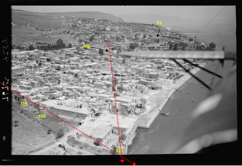 Fig. 49
1931: air photo of Tiberias taken south of the city (ACPD, 1931b). Note that some dwellings at the beginning of the 20th century were built on top of existing turrets (e.g., T19 and T20). The red dotted line assists in geo-tagging the location of the photographing camera/airplane (Fig. 3) Zohar (2017) |
Figure 49 | Aerial Photo of Tiberias 1931 CE | Zohar (2017) |
 Fig. 50
1938: British map of Survey of Palestine, 1938 (Survey of Palestine, 1938) Zohar (2017) |
Figure 50 | Map of Tiberias in 1938 CE | Zohar (2017) |
| Image | Figure | Description | Source |
|---|---|---|---|
|
Fig. 1 1681: Tiberias walls before the reconstruction of Dahir al-Umar. Note the church of St. Peter (C1) and the probable location of the Jewish quarter (de-Bruyn, 1702) Zohar (2017) |
Figure 1 | Painting of Tiberias in 1681 CE | Zohar (2017) |
|
Fig. 2 1799: Tiberias at the end of the 18th century as mapped by Jacotin for military purposes. Note the roads leading to the city and the fact that there is no road entering Tiberias from the north. See also the location of the main (G1) and southern (G2) gates (Jacotin, 1799) Zohar (2017) |
Figure 2 | Map of Tiberias in 1799 CE | Zohar (2017) |
|
Fig. 3 1810-12: Tiberias at the beginning of the 19th century (in brackets - identification according to Table 3)
(Burckhardt, 1822) Note that Burckhardt confuses the number of turrets (counts 25 instead of 21) and neglects a northern turret (T1) Zohar (2017) |
Figure 3 | Map of Tiberias in 1810-1812 CE | Zohar (2017) |
|
Fig. 4 1814: al-Zaydani mosque drawn from close range within the city itself (Light, 1818). Note the relatively large dome also present in other pre-1837 drawings (e.g., Buckingham, 1822; Marilhat in de Laborde, 1837; Wilson, 1823). Zohar (2017) |
Figure 4 | al-Zaydani Mosque in 1814 CE compared to ~2016 CE | Zohar (2017) |
|
Fig. 5 1816: Buckingham draws the citadel (P1) as having only one turret but the other turrets (e.g., T10, T16, T20, T21) seems to be drawn correctly. Note the al-Zaydani mosque (M1) (Buckingham, 1822). Zohar (2017) |
Figure 5 | Painting of Tiberias in 1816 CE | Zohar (2017) |
|
Fig. 6 1822: al-Zaydani (M1) and al-Bahri (M2) mosques. The minaret of al-Zaydani is portrayed relatively high above the dome. Note the possible identification of St. Peter church (C1) (Wilson, 1823). Zohar (2017) |
Figure 6 | Painting of Tiberias in 1822 CE | Zohar (2017) |
|
Fig. 7 1828: Tiberias from the south in the book of Leon de Laborde. The latter visited Palestine in 1828 but his book on Syria, Lebanon and Palestine was published only in 1837. The book contains also other artist’s drawings. This drawing was drawn by Marilhat and considered realistic. For example, the number of turrets and location of the citadel are accurate in light of our current knowledge of the Tiberias morphology (Marilhat in de Laborde, 1837) Zohar (2017) |
Figure 7 | Painting of Tiberias in 1828 CE compared to ~2016 CE |
Zohar (2017) |
|
Fig. 8 1828: Tiberias from the west (de Laborde, 1837). Note the accuracy in counting the turrets: six (T16-T21) at the south of the city and six (T10‐T15) at its western side. Zohar (2017) |
Figure 8 | Painting of Tiberias in 1828 CE compared to ~2016 CE |
Zohar (2017) |
|
Fig. 9 1832: The city drawn from the north (Russell, 1832). Zohar (2017) |
Figure 9 | Painting of Tiberias in 1832 CE | Zohar (2017) |
|
Fig. 10 1833: Sketch of Tiberias drawn from northeast of the city. Despite the exaggerated topography one can detect prominent features, e.g., the western main gate (G1) and the surrounding turrets. Note that two minarets appear, probably of the al-Zaydani (M1) and al-Bahri (M2) mosques (Skinner, 1836). Zohar (2017) |
Figure 10 | Painting of Tiberias in 1833 CE | Zohar (2017) |
|
Fig. 11 1835: The town from the north. Note the turrets and the two minarets of al-Zaydani and al-Bahri mosques (Harding, 1835). The drawing was probably copied from the drawing of Marilhat (in de Laborde, 1837). Zohar (2017) |
Figure 11 | Painting of Tiberias in 1835 CE | Zohar (2017) |
|
Fig. 12 Prior to 1837 (1835?): Tiberias and the Sea of Galilee. No significant identification of features (Thomas Allom in Carne, 1838). Zohar (2017) |
Figure 12 | Painting of Tiberias Prior to 1837 CE (1835?) |
Zohar (2017) |
|
Fig. 13 Prior to 1837: Tiberias from the south (Lindsay, 1858). The drawing portrays Tiberias prior to the earthquake but the date is unresolved. The drawing appears only in the 5th edition of the book of Lord Lindsay published in 1858. However, Lindsay visited Palestine only after the earthquake, in 1837 and 1847. Thus, in my opinion, it was copied from a previous drawing, perhaps from Marilhat (de Laborde, 1837). Zohar (2017) |
Figure 13 | Painting of Tiberias Prior to 1837 CE | Zohar (2017) |
|
Fig. 14 Prior to 1837: Tiberias from the north (Leitch & Foster, 1855). In my opinion, this is probably a copy of the sketch after Marilhat (de Laborde, 1837). Zohar (2017) |
Figure 14 | Painting of Tiberias Prior to 1837 CE | Zohar (2017) |
|
Fig. 15 Prior to 1837: Tiberias from the south (Leitch & Foster, 1855). In my opinion, this is probably a copy of the sketch after Marilhat (de Laborde, 1837). Zohar (2017) |
Figure 15 | Painting of Tiberias Prior to 1837 CE | Zohar (2017) |
|
Fig. 16 1837: Tiberias after the earthquake drawn from the south. Note the damage to the citadel (P1), to the walls and to its turrets (T4‐T17). The Jewish quarter is depicted as partially destroyed while in the Muslim and Christian quarters there are hardly any standing dwellings. The drawing seems to be realistic: parts of the walls (e.g., W7b, W8a, and W16) and turrets (e.g., T8, T10 and T16) that were drawn as not destroyed still exist till today (Lehoux in de Laborde, 1837). Zohar (2017) |
Figure 16 | Painting of Tiberias in 1837 CE after the earthquake compared to ~2016 CE |
Zohar (2017) |
|
Fig. 17 Before 1837: The drawing portrays Tiberias prior to the earthquake but the date of painting is unresolved. It appears only in the 5th edition of Lindsay (1858). Lindsay visited Palestine twice and only after the earthquake (1837 and 1847) and thus, in my opinion, the drawing is a copy of a previous one, perhaps of Lehoux (de Laborde, 1837) Zohar (2017) |
Figure 17 | Painting of Tiberias before 1837 CE | Zohar (2017) |
|
Fig. 18 1837: Tiberias from the north, after the voyage of Bernatz and Schubert (Bernatz & Schubert, 1839). The drawing seems to be realistic as prominent features (e.g., W8 and T10) are depicted in similar shape and size as they are today. Zohar (2017) |
Figure 18 | Painting of Tiberias in 1837 CE compared to ~2016 CE |
Zohar (2017) |
|
Fig. 19 . 1839a: Damage to the citadel and walls. Note the completeness of the Seraiah (P2) and the presence of the minaret of al-Zaydani mosque (M1) (Roberts, 1842-1849). Zohar (2017) |
Figure 19 | Painting of Tiberias in 1839 CE | Zohar (2017) |
|
Fig. 20 1839b: Tiberias from the south. Note the arched vaults (P8), al-Zaydani mosque and minaret but no dome, the ruined citadel (P1), the Seraiah (P2), a Synagogue (Etz Hayim?, S1), turret T1 in the water, and St. Peter church (Roberts, 1842-1849). Zohar (2017) |
Figure 20 | Painting of Tiberias in 1839 CE | Zohar (2017) |
|
Fig. 21 1839c: The western walls are drawn as partially ruined (Roberts, 1842-1849). Zohar (2017) |
Figure 21 | Painting of Tiberias in 1839 CE | Zohar (2017) |
|
Fig. 22 1839d: The citadel (P1) is depicted partially ruined; the Seraiah (P2); the walls that are partially ruined, al-Zaydani mosque without a dome (Roberts, 1842-1849). Note turret T21 leaning towards the east and its lower supporting belt (noted by red arrow). Zohar (2017) |
Figure 22 | Painting of Tiberias in 1839 CE | Zohar (2017) |
|
Fig. 23 1840: Tiberias from the south, probably from a spot close to the thermal baths. The depiction of the city is vague but one can detect the citadel (P1) drawn as slightly damaged and few turrets (T1, T2 and T21) (Egerton, 1841) Zohar (2017) |
Figure 23 | Painting of Tiberias in 1840 CE | Zohar (2017) |
|
Fig. 24 1841: Tiberias from the south by Barnes (1841). Although few features are depicted differently, it seems that this drawing was copied from the drawing of Egerton (1841). Yet, note that in this drawing the lean of T1 and T2 is clearly seen. Zohar (2017) |
Figure 24 | Painting of Tiberias in 1841 CE | Zohar (2017) |
|
Fig. 25 1841: Ruins of Tiberias. The citadel (P1) is depicted as slightly damaged (Munk, 1845). Zohar (2017) |
Figure 25 | Painting of Tiberias in 1841 CE | Zohar (2017) |
|
Fig. 26 1842a: Tiberias and its citadel in a drawing drawn from the north (Bartlett in Stebbing, 1847). Note the similarity of T4 and T5 to their recent state (upper left corner) and the accuracy of the hatch (red square) as drawn by Bartlett Zohar (2017) |
Figure 26 | Painting of Tiberias in 1842 CE compared to ~2016 CE |
Zohar (2017) |
|
Fig. 27 1842b: Tiberias drawn from the thermal baths. Note the four turrets that erect above the others (probably ruined) and remains of damaged walls (Bartlett in Stebbing, 1847). Zohar (2017) |
Figure 27 | Painting of Tiberias in 1842 CE | Zohar (2017) |
|
Fig. 28 1842c: Tiberias from the west. Several turrets seem to be relatively higher than the others and in the western walls large breaches appear (Bartlett in Stebbing, 1847). Zohar (2017) |
Figure 28 | Painting of Tiberias in 1842 CE | Zohar (2017) |
|
Fig. 29 1842d: Tiberias view drawn from the citadel of Safed. Note the citadel of Tiberias (P1) (Bartlett in Stebbing, 1847). Zohar (2017) |
Figure 29 | Painting of Tiberias in 1842 CE | Zohar (2017) |
|
Fig. 30 1842e: sketch of Tiberias from the west. Large breaches appear in the western and southern walls of the city (Bartlett, 1850). Zohar (2017) |
Figure 30 | Sketch of Tiberias in 1842 CE | Zohar (2017) |
|
Fig. 31 1842f: the leaning turret (T21) and the citadel (P1) (Bartlett, 1850). Zohar (2017) |
Figure 31 | Painting of Tiberias in 1842 CE | Zohar (2017) |
|
Fig. 32 1848: Tiberias from the north, probably drawn somewhere on the hill of the citadel (Lynch, 1849). Prominent features:
Zohar (2017) |
Figure 32 | Drawing of Tiberias in 1848 CE compared to ~2016 CE |
Zohar (2017) |
|
Fig. 33 1849: the road from Safed leading to Tiberias, the citadel and the walls (Spencer, 1850). Zohar (2017) |
Figure 33 | Painting of Tiberias in 1849 CE | Zohar (2017) |
|
Fig. 34 1851: The citadel of Tiberias from the north (Schulz, 1852). One can observe a trail leading from the shore of the lake of Galilee into the city. Zohar (2017) |
Figure 34 | Painting of Tiberias in 1851 CE | Zohar (2017) |
|
Fig. 35 1851-52: Tiberias from the south (Van de Velde, 1857). Zohar (2017) |
Figure 35 | Painting of Tiberias in 1851-52 CE | Zohar (2017) |
|
Fig. 36 1856 (?): the region surrounding the Sea of Galilee (Robinson & Smith, 1856) Zohar (2017) |
Figure 36 | Map of the region in 1856 (?) CE | Zohar (2017) |
|
Fig. 37 1860: Tiberias from the south (Strauss, 1861). Zohar (2017) |
Figure 37 | Painting of Tiberias in 1860 CE | Zohar (2017) |
|
Fig. 38 1863: Tiberias from the western road leading to the main gate. Note the possible identification of turret T17 (Unknown, 1867). In my opinion the drawing was copied from Munk (1845). Zohar (2017) |
Figure 38 | Drawing of Tiberias in 1863 CE compared to ~2016 CE |
Zohar (2017) |
|
Fig. 39 c.1870: a photograph probably taken from the hill of the citadel (Bonfils, 1878?). The northern region was not populated. No minaret of al-Bahri mosque, no dome to al-Zaydani. Zohar (2017) |
Figure 39 | Photo of Tiberias c.1870 CE | Zohar (2017) |
|
Fig. 40 1880: Map of the Sea of Galilee and Tiberias (Lvov, 1880). Zohar (2017) |
Figure 40 | Map of the Sea of Galilee and Tiberias in 1681 CE |
Zohar (2017) |
|
Fig. 41 1880: Tiberias and its close vicinity (PEF, 1918). Zohar (2017) |
Figure 41 | Map of Tiberias and vicinity 1880 CE | Zohar (2017) |
|
Fig. 42 1885 (?): Tiberias towards the end of the 19th century (Frei, 1885). Zohar (2017) |
Figure 42 | Plan of Tiberias in 1885 (?) | Zohar (2017) |
|
Fig. 43 1900-1920: (ACPD, 1900‐1920). Zohar (2017) |
Figure 43 | Aerial Photo of of Tiberias 1900-1920 CE | Zohar (2017) |
|
Fig. 44 1898-1914: (ACPD, 1898-1914a): large breaches in the western walls, similar to the drawings of Lehoux 1837 (item 16). Note the new dome of al-Zaydani mosque (M1) and that there is no minaret to al-Bahri mosque. Turrets T16-T17 marks the transitions between unharmed and harmed part of the southern wall. A southern road entering the city, probably an expansion of a large breach in the walls, is clearly observed. Zohar (2017) |
Figure 44 | Photo of Tiberias between 1898 and 1914 CE | Zohar (2017) |
|
Fig. 45 1898-1914: (ACPD, 1898-1914b) Zohar (2017) |
Figure 45 | Photo of Tiberias between 1898 and 1914 CE | Zohar (2017) |
|
Fig. 46 1898-1946: (ACPD, 1898-1946b) Zohar (2017) |
Figure 46 | Photo of Tiberias between 1898 and 1946 CE | Zohar (2017) |
|
Fig. 47 1898-1946: (ACPD, 1898-1946a) Zohar (2017) |
Figure 47 | Photo of Tiberias between 1898 and 1946 CE | Zohar (2017) |
|
Fig. 48 . 1931: air photo of Tiberias taken from north of the city (ACPD, 1931a). The W2 part of the walls seems to be compatible with the drawing of Bartlett (item 26) and strengthens the claim that the northern parts of the walls were not affected significantly. Other breaches in the northern walls (E.g., the breach of the northern road to the city) might have been extended only after the event. The red dotted line assists in geo-tagging the location of the photographing camera/airplane (Fig. 3) Zohar (2017) |
Figure 48 | Aerial Photo of Tiberias 1931 CE | Zohar (2017) |
|
Fig. 49 1931: air photo of Tiberias taken south of the city (ACPD, 1931b). Note that some dwellings at the beginning of the 20th century were built on top of existing turrets (e.g., T19 and T20). The red dotted line assists in geo-tagging the location of the photographing camera/airplane (Fig. 3) Zohar (2017) |
Figure 49 | Aerial Photo of Tiberias 1931 CE | Zohar (2017) |
|
Fig. 50 1938: British map of Survey of Palestine, 1938 (Survey of Palestine, 1938) Zohar (2017) |
Figure 50 | Map of Tiberias in 1938 CE | Zohar (2017) |