Karak

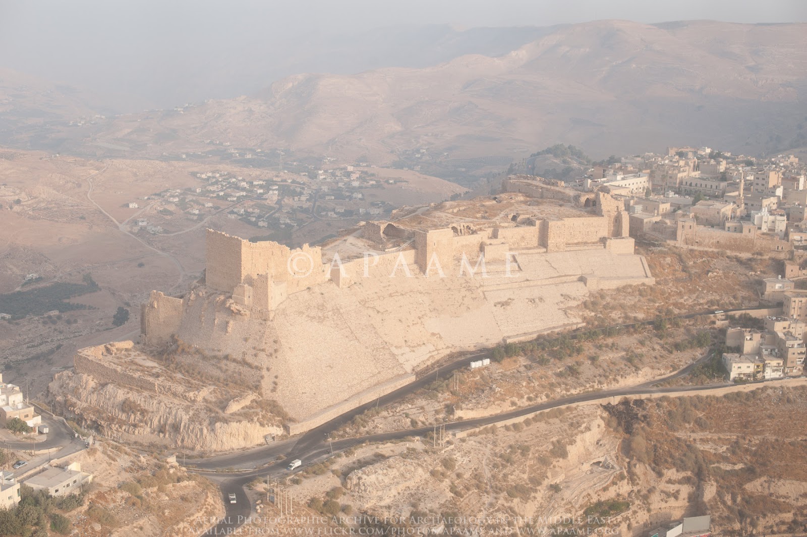
APAAME
- Reference: APAAME_20151013_RHB-0018.jpg
- Photographer: ?
- Credit: Aerial Photographic Archive for Archaeology in the Middle East
- Copyright: Creative Commons Attribution-Noncommercial-No Derivative Works
| Transliterated Name | Source | Name |
|---|---|---|
| Al-Karak | Arabic | ال كاراك |
| Kerak | Arabic | خربة |
| Karak | Kingdom of Jerusalem | |
| Crac | French | |
| Kharkha | Aramaic | כרכא |
| Characmoba |
- from Chat GPT 4o, 29 June 2025
- sources: Karak (Wikipedia), Moab (Wikipedia), Johns in Meyers et al. (1997), Kerak Castle (Wikipedia)
In the early 12th century CE, during the Crusader period, the Kingdom of Jerusalem constructed a large hilltop fortress known today as Kerak Castle. This imposing stronghold, which still dominates the city skyline, became one of the most important military outposts in the region, controlling caravan routes and resisting sieges for centuries.
Kerak was an important Moabite center. A Moabite inscription [the Mesha Stele] names Mesha, or his father Chemosh-yat, mid-ninth-century BCE kings of Moab, and suggests that Kerak had a temple to the god Chemosh. The place names Qir-Mo'ab (Is. 15:1), Qir-Heres (Jer. 48:31, 48:36; Is. 16:11), and Qir-Hareset (Is. 16:7; 2 Kgs. 3:25) are thought to refer to Kerak, perhaps because the Isaiah Targum renders Qir-Mo'ab by the Aramaic Karka' de-Mo'ab. If correct, then Kerak was an important fortress in the revolt of Mesha against Israel and the site of the dramatic siege in 2 Kings 3:25-27. Kerak cannot be the Qarhoh on Mesha's stela, which was evidently a quarter of Dibon.
Kerak was the administrative center of Moab during the Persian period (539/520-332 BCE) . Nabatean pottery is commonly found there and Nabatean-Roman spolia (architectural and decorative fragments) are reused in the castle. In about 130 Hadrian granted polis status to Kerak, which later had its own mint. The Madaba map (mid sixth century CE) shows [Khara] khmoba as a walled, hilltop city.
Early in the twelfth century CE, the kings of Jerusalem built a line of fortifications to protect their revenue from TransJordan and to dominate the trade routes
- al-Habis (Crusader, Cava de Suet, Cave de Sueth; Ar., 'Ayn Habis, al-Habls, Habis Jaldak), pre-1109(?)
- Montreal (Crusader, Mons regalis, Mont royal, Montreal; Ar., al-Shawbak), 1115
- Ayla (Crusader, Helim), 1116-17(?)
- Ile de Graye (Ar., Jazira Fara'un, al-Qurayyah), 1116-17(?)
- Li Vaux Moys (Crusader, Li Vaux Moys, Castellum Vallis Moysis; Ar., al-Wuayra)
- two other castles in the Petra region
- Celle (Ar., al-Sal'a[?])
- Hormoz (Ar., al-Habis [?]), 1127(?).
Oultrejourdain was kept mostly in the royal domain until about 1126 when it was granted to Pagan the Butler (Romain de Puy was not the first lord of Oultrejourdain but held lands in the Balqa'). The crown retained some castles and lands until 1161 , when Baldwin III invested Philip de Milly with all royal property from Wadi Zarqa to the Red Sea. The lordship was crucial to the defense of the kingdom and was economically important: it exported bitumen, dates, grain, oil, salt, sugar, and wine. Kerak had its own Dead Sea port. Tolls were levied on caravans and bedouin passing through the region.
In 1142, Pagan built Kerak castie (Crusader, Chrac, Crac [not to be confused with Crac des Chevaliers in Syria], Crac de Montreal/Mont royal, Cracum Montis regalis, Petra Deserti, Pierre dou Desert, Civitas Petracensis; Ar., al-Karak, Karak al-Shawbak) to replace Montreal as the center of Oultrejourdain. His successors, Maurice and Philip de Milly, strengthened it. Philip entered the Templars in about 1165 and was succeeded by his daughter [Stephanie]'s husbands, first Miles de Plancy (1172-1174) and then Reynald de Chatillon (1177-1187). Nur al-Din and Salah ad-Din attempted to take Kerak in 1170 and 1173 . When Reynald used Kerak as a base for raids on caravans protected by treaty and on al-Hijaz, Salah ad-Din launched systematic assaults (1183, 1184, 1187). Reynald was killed after the Battle of Hattin in July 1187. In November 1188, after a siege of eight months, Kerak capitulated.
Under the Ayyubids (1193-1263), Kerak usually belonged to the independent Syrian principality of Damascus, although al-Nasir Dawud (1227-1249) and al-Mughith 'Umar (1250-1263) ruled Kerak as a semiautonomous principality. Al-'Adil (1193-1198) refortified the castle, converted the cathedral into a mosque, and founded a mosque in Wadi Kerak. Al-Mu'azzam (1198-1227) repaired the castle after the earthquake of 1211 [JW: 1212], constructed the western entrance tunnel, and ordered the improvement of the Hajj road from Damascus to al-Hijaz (work at Mu'ta and Ma'an was completed). Further refortification was carried out under al-Nasir Dawud, who built a palace within the castle. Al-Mugith 'Umar repaired damage caused by the 1261 earthquake1.
Under the Mamluk sultans (1263-1517), Kerak became the chief town of an administrative province stretching from Ziza to 'Aqaba and from the Dead Sea to the desert. Kerak's prosperity was largely dependent on the patronage of the sultans, although the region continued to export agricultural products, especially sugar. Baybars I (1260-1277) visited Kerak frequently and undertook its major refortification. In the late thirteenth and fourteenth centuries, Kerak was used as a school where the sons of the dynasty could be educated in Arab ways and as a place of exile for troublesome members of the ruling family. Al-Nasir Muhammad spent two periods of exile in Kerak (1294- 1298, 1308-1310) and in 1311 had a palace, bath, school, khan, hospital, and mosque built there. For a few months in 1342, under al-Nasir Ahmad, Kerak became the capital of the Mamluk state. During the fifteenth century, Mamluk interest in Kerak waned, and local tribes increasingly came to dominate the town.
In 1517, an Ottoman governor was installed at Kerak. The Ottomans attempted to retain control of the town throughout the sixteenth century, but soon after 1600 it was in Arab hands. Successive Ottoman expeditions (1655-1656, 1678-1679, 1710-1711) failed to regain control.
1 JW: I'm not sure what earthquake he is referring to or what his source is. Guidoboni and Comastri (2005) list an earthquake report from Syria between 1 Oct. 1261 CE and 30 Sept. 1262 CE. Below are catalog entries from around this time
(119) 1259 March 22 Damascus [south-western Syria]
sources
- al-Maqrizi, al-Suluk, I, p.426
- BNFrance, ms. Ar. 1597, Ibn Duqmaq, Nuzhat, fol.117r.
- Ibn al-Dawadari, Kanz, VIII, p.44
- Taher (1979)
- Sieberg (1932a)
- Ben-Menahem (1979)
- Poirier and Taher (1980)
- al-Hakeem (1988)
"The emirs Badr al-Din Muhammad ibn Qarmaja, governor of the citadel of Damasci and Jamal al-Din ibn al-Sayrafi had risen in rebellion and closed the gates [of the cit Kitbuga [a Mongol general] laid siege to the citadel with his men on the night of Ra II [22 March]. God sent rain, cold, wind, thunder and lightning, and an earthqua which caused collapses in many places. The populace spent the night amidst fear the earth and fear of the heavens, and the revolt failed".The Egyptian Arab historian Ibn Duqmaq (1349-1406) combines the earthquakes in Egypt and Syria when he records:
"In this year, there was a violent earthquake in Cairo and the other Egyptian territories, and there were numerous shocks in Syria at the time when the Tartars arrived, for they crossed the Euphrates and invaded the region of Aleppo, and many citizens of Damascus fled and put their goods up for sale and wandered around in terror and scattered through the meadows and mountains and some of them made their way towards Egyptian territory. It was midwinter, and many died of cold, and others were robbed as they travelled".There is a very brief report of the earthquake in Ibn al-Dawadari, an Arab historian who was active in the late 13th and early 14th century:
"The shocks were very numerous throughout Syrian territory because of the Tartars"Sieberg (1932a, p.40) is probably making a dating error when he mentions an earthquake in north-east Syria in 1254.
Guidoboni, E. and A. Comastri (2005). Catalogue of Earthquakes and Tsunamis in the Mediterranean Area from the 11th to the 15th Century, INGV.
(120) 1261 October 1 - 1262 September 30 [1573 S. e.] Syria
source
- Elias Nisib., Opus [continuation], p.229
- Grumel (1958)
"And in the year fifteen hundred and seventy-three of the Greeks [1 October 1261 - 30 September 1262], Bar Badr al-Din fled to Egypt and in the same year there was an earthquake among the Syrians".
Guidoboni, E. and A. Comastri (2005). Catalogue of Earthquakes and Tsunamis in the Mediterranean Area from the 11th to the 15th Century, INGV.
AD 1259 Jun 6 Cairo
Earthquakes were felt in Cairo and the other towns in
Egypt on 12 Jumada 657 a.H. They are mentioned by
Imad al-Din, Ibn Duqmaq (Nuzhat, fol. 117ro) and al-
‘Aini (Iqd, i. 224), but none of these are contemporary authors. This preceded the news of the Mongols’
advance and is possibly a reference to the political situation in Egypt, which was undergoing a prolonged dynastic
upheaval (Irwin 1986, 26–36).
Some sources refer only to the strength of disquieting rumours (arajif) flying around at this time. The root
meaning of r-j-f is to tremble or shake (Ibn al-Dawadari
viii. 44).
Numerous problems surround the reporting of
this event in the secondary sources. Lyons (1907, 284)
duplicates the event, putting it first under 28 May 1260
and then again on 12 Jumada II, 657, which is erroneously converted as 21 February 1263. Lyons cites
Quatremere’s translation of al-Maqrizi (I/i. 98) for the `
first event, and simply al-Maqrizi for the second. Quatremere (I/i. 89) in fact only has the 12 Jumada II, `
657 event: but the translation is misleading. Neither alMaqrizi nor Quatremere mentions an earthquake on 28 `
May 1260, which would be the equivalent of 15 Jumada II,
658 a. H.
Al-Maqrizi’s Arabic text, which is usually cited for
the date given above, merely reads ‘in this year there were
numerous earthquakes in Egypt’; and it goes on to record
another event, which occurred on 12 Jumada II. In other
words, this date does not belong to the earthquake at
all. Guidoboni and Comastri (2005, 272), place this earthquake in Damascus and date it 22 March 1259.
The shock, if genuine, must in fact have occurred
sometime shortly before 6 June of this year.
Ambraseys, N. N. (2009). Earthquakes in the Mediterranean and Middle East: a multidisciplinary study of seismicity up to 1900.
[AD 1261 Acre]
Ajami mentions that in a.H. 659 (6 December 1260 to 25
November 1261) seven islets sank off the coast of Acre.
No earthquake is mentioned and details are not known.
In a.H. 659 seven islets near Acre sank into the sea, drowning many people.(Ajami, viii. 13b/9).
Ambraseys, N. N. (2009). Earthquakes in the Mediterranean and Middle East: a multidisciplinary study of seismicity up to 1900.
AD 1262 Lower Iraq
An earthquake occurred in Lower Iraq. No details are
known.
This event is recorded by al-Qalqachandi, who
dates it to a.H. 660 (26 November 1261 to 14 November
1262). He locates it in ‘Sawad al-Iraq’, meaning ‘the black
ground’, used as synonymous with Lower Iraq, coming to
mean the whole province of Babylonia in southern Iraq.
It may be the same earthquake as that in 1573
a.S. (1 October 1261 to 30 September 1262) which is
mentioned by the continuator of Elias Nisibinus (Eli.
Nis. 229/113) and reported by the Syrians, recorded by
Grumel (1958, 481).
(a.H. 660) The earth shook in Iraq, in the region of Sawad al-Iraq.(al-Qalqashandi Maath. 2/114).
Ambraseys, N. N. (2009). Earthquakes in the Mediterranean and Middle East: a multidisciplinary study of seismicity up to 1900.
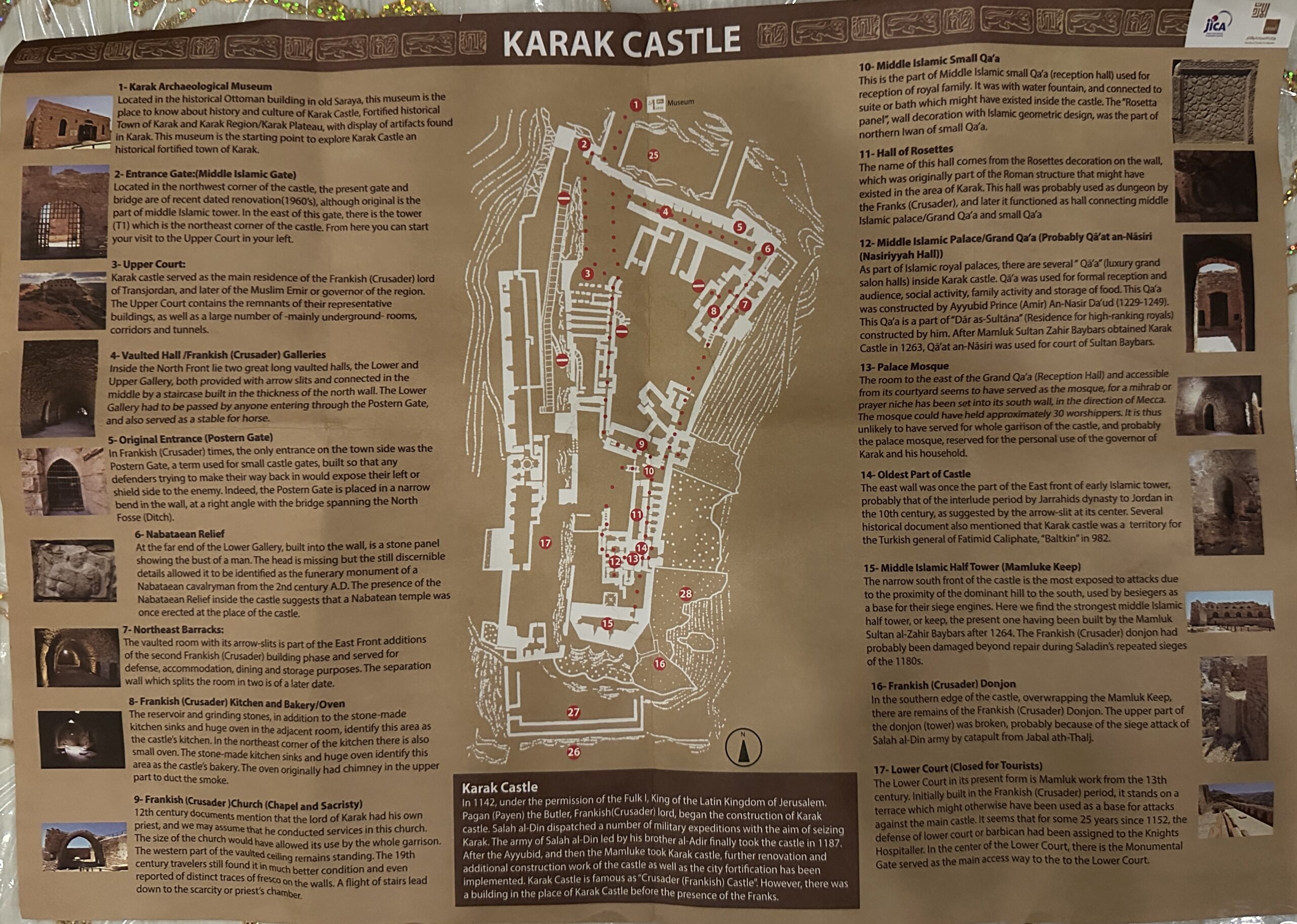
- Fig. 1 Plan of the Karak
Castle from Brown (1989)

 Figure 1
Karak castle plan (adapted front Biller et al. 1999: 46, fig. 9).
Brown (1989) - Tourist Map of the Karak Castle
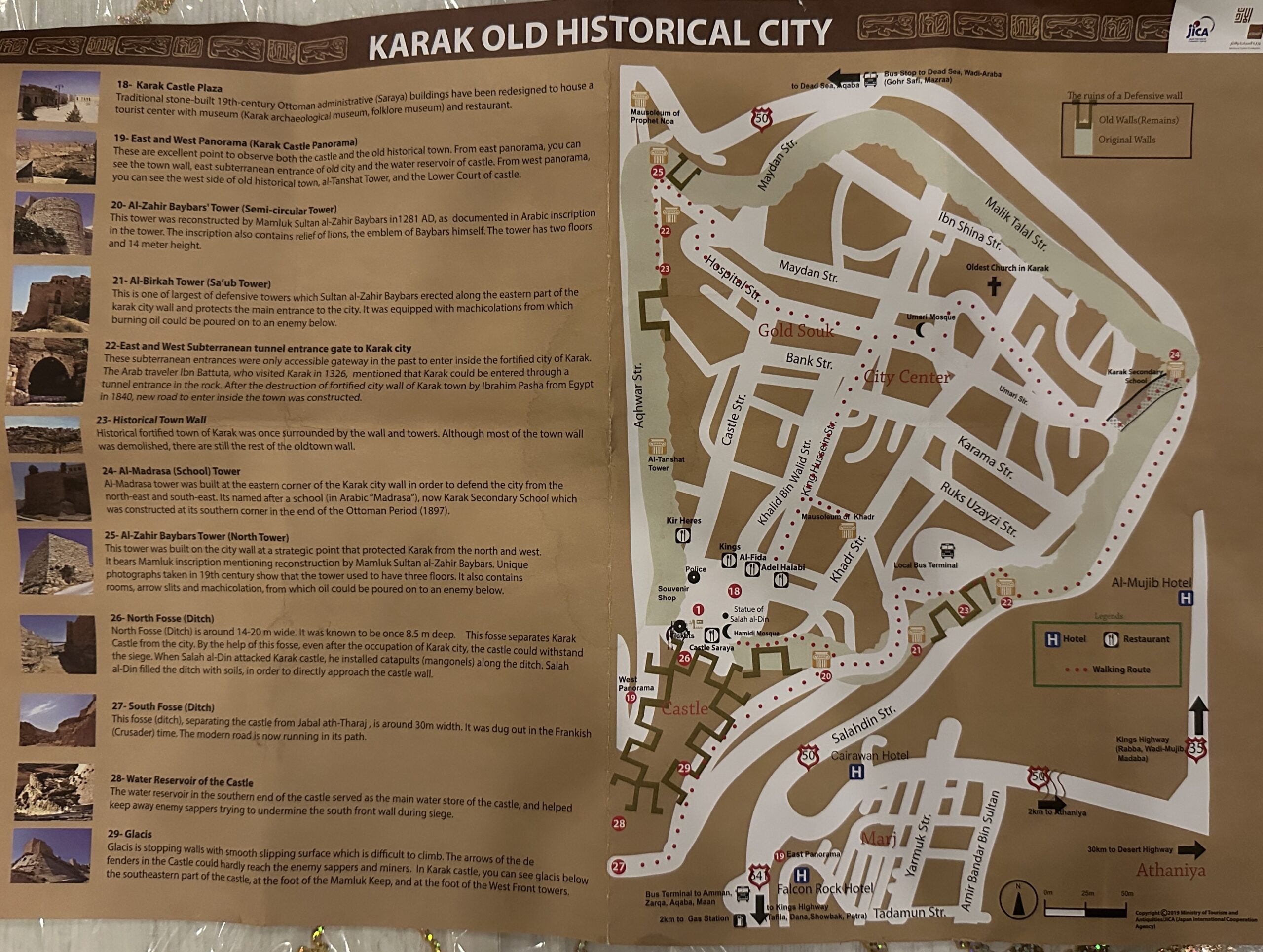
- Tourist Map of the Old City of Karak
- Fig. 1 Plan of the Karak
Castle from Brown (1989)

 Figure 1
Karak castle plan (adapted front Biller et al. 1999: 46, fig. 9).
Brown (1989) - Tourist Map of the Karak Castle
- Tourist Map of the Old City of Karak
Sinibaldi (2014:75) reports the following:
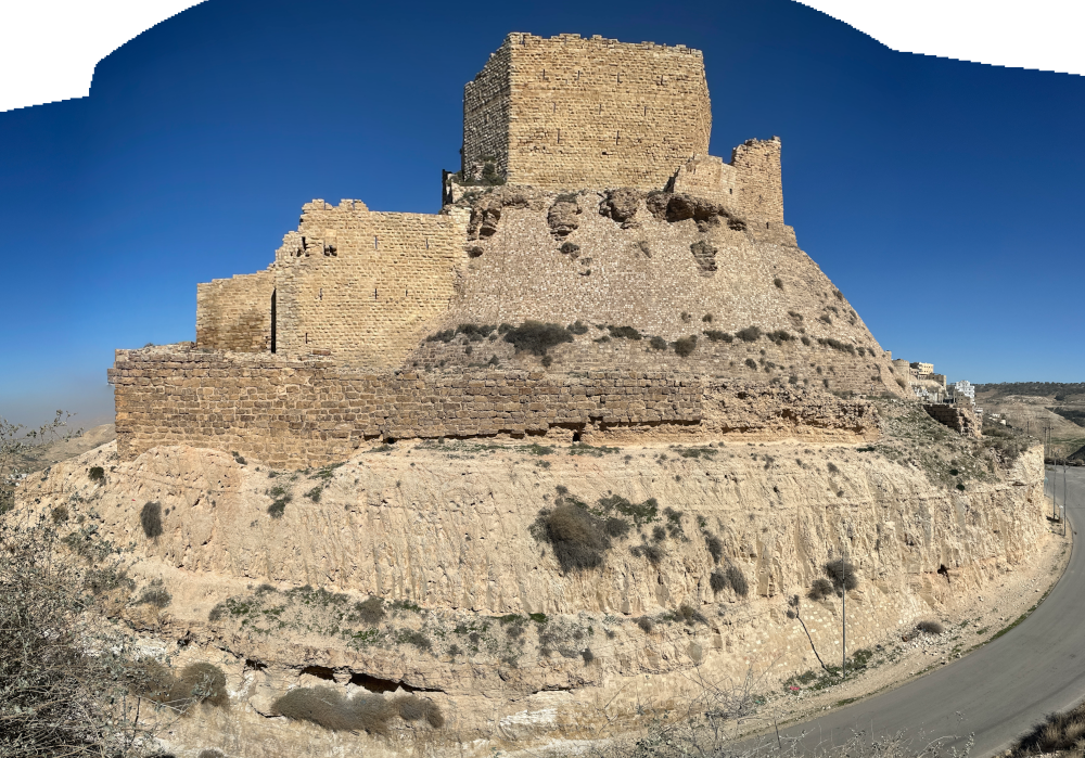
Today the best preserved tower, which Deschamps calls a donjon, is actually a Mamluk construction, as appears both from an inscription set in it and its similarities to the tower at Shawbak, which is dated by an inscription to 1297-1298; however, this is not a donjon but a building with the function of shielding the areas behind it. Next to it there are remains assigned by Deschamps to two pre-Mamluk phases. The earliest remains of a first construction phase are south and west of the Mamluk structure and are bonded to the original western wall of the castle; this wall ends with a very wide projection which should then be interpreted as the remains of this southern building, also belonging to the construction of c.1142. The minimal remains of the southern wall of this 35 m-long building are constructed directly on bedrock and the southeastern corner, built in good quality masonry, is also still visible. The existence of a further wall behind it (its internal wall) proves that this was a building and not part of the enceinte. Therefore, the hypothesis of the most recent survey is that this is a long narrow donjon of the original Crusader phase, badly damaged by one of Saladin’s assaults and probably also by an earthquake, since it stood on the edge of the cliff. In addition, there was also a later Frankish expansion: a wall running E–W, between the Crusader donjon and the Mamluk building, and characterized by a Crusader-period building technique, bossed stones, as seen elsewhere in the castle, namely in the projections of the original 1142 phase in both the original western wall enceinte and the northern wall. Its presence does not imply the destruction of the Crusader donjon, but it is reasonable to assume that it replaced it. It is also contemporary in its use, though perhaps not necessarily in its construction, to the reinforcement of the eastern wall of the castle and to the remains of the enceinte external to the Crusader donjon. The German surveyors interpret these three constructions as a protection measure against Saladin’s attacks,419 and therefore, to be placed chronologically after 1170.Footnotes419 Biller et al. 1999, 50-52.
R.M. Brown, 1989, Excavations in the 14th Century Mamluk
Palace at Kerak, in: Annual of the Department of Antiquities of Jordan 33, 1989, 287–304.
R.M. Brown, 2013, The Middle Islamic Palace at Karak
Castle: a new Interpretation of the Grand Qāʻa (Reception Hall), in: Annual of the Department of Antiquities
of Jordan 57, 2013, 309–335.
S. M. al-Momani, 2010, The Shrine of Bahadir bin Abdullah
al-Badri in al-Mazar al-Janubi, al-Karak. An archaeological and architectural Study (Arabic), in:Jordan Journal
of History and Archaeology 4, 4, 2010, 139–170
al-Bakhit, M. A.
1992 Das Konigreich von al-Karak in der mamlakischen Zeit. Aus dem arabischen Ge-schichtswerk von Muhammad
`Adnan al-Bahrt ubersetzt and ausfuhrlich erlautert; Alexander Scheidt. Frankfurt am Main: Peter Lang.
Biller, T., Burger, D. and Häffner, H.:
1999 ‘Neues zu den Burgen des Königreichs Jerusalem in Transjordanien:
Montréal (Shobaq)-Li Vaux Moïses (Wu'eira)-Kerak’, in M. Kozok
(ed.), Architektur, Struktur, Symbol: Streifzüge durch die
Architekturgeschichte von der Antike bis zur Gegenwart: Fest
Bini, M., 2009 The Eastern Border. The Wu'ayra Fortifications — Habis Castle — Shoubak Castle — Kerak Castle. Pp. 15-40 in M. Bini and C. Luschi (eds.),
Castelli e cattedrali. Sulle tracce del regno cro-ciato di Gerusalemme. Resoconti di viaggio in Israele. Firenza: Alinea.
Brown, R. M., 1988a Report of the 1987 Excavation at Kerak Castle: The Mamluk Palace Reception Hall.
Document on file at the American Center of Oriental Research and the Department of Antiquities, Amman.
Brown, R. M., 1989b Kerak Castle. Pp. 341-347 in Archaeology of Jordan 11.1.
Field Reports: Surveys & Sites L-Z. Akkadica Supplementum VII, ed. D. Homes-Fredericq and J. B. Hennessy. Leuven: Peeters.
Dowling, T. E.
1896 Kerak in 1896. Palestine Exploration Fund Quarterly Statement: 327-332.
Johns, J.
1992 Islamic Settlement in Ard al-Karak. Studies in the History and Archaeology of Jordan 4: 363-368.
Kennedy, H.
1994 Crusader Castles. Cambridge: Cambridge University Press.
Lee, J. R.
2003 Kerak Castle - The 1997 Church Excavations.
Paper presented at the Archaeology of Crusader States & Medieval Culture symposium, St. Lou¬is Community College — Florissant Valley, St. Louis.
Miller, J. M., ed.
1991 Archaeological Survey of the Kerak Plateau. Atlanta: Scholars.
Sinibaldi, M. (2014). Settlement in Crusader Transjordan (1100–1189):a historical and archaeological study.
Brown, Robin M. "Excavations in the Fourteenth Century A.D. Mamluk Palace at Kerak." Annual of the Department of Antiquities of Jordan
33 (1989): 287-304. Brief excavation report.
Canova, Reginetta. Iscrizioni e monumenti protocristiani del paese di
Moab. Sussidi alio Studio delle Antichita Cristiane, 4. The Vatican,
1954. Fundamental guide to the Christian inscriptions and monuments of Kerak.
Deschamps, Paul. Les Chateaux des Croises en Terre-Sainle, vol. 2, La
defense du royaume de Jerusalem. Bibliotheque Archeologique et Historique, vol. 34. Paris, 1939. Still the only attempt at a thorough
survey of the castle and town fortifications.
Ghawanmah, Yusuf D. Imdrat al-Karak al-Ayyubiyyah. Kerak, 1980.
The only existing study of Ayyubid Kerak; includes an English summary. Alternatively, see Humphreys below.
Ghawanmah, Yusuf D. Tar'Tkh sharqi al-Urdunn ft 'asr dawlat al-Mamalik. 2 vols. Amman, 1979. The only existing study of Mamluk
Kerak; includes an English summary. Alternatively, see Irwin and
Thorau below.
Gibson, John C. L . Textbook of Syrian Semitic Inscriptions, vol. I, Hebrew
and Moabite Inscriptions. Oxford, 1971 . See pages 71-8 3 for the
Mesha stela and the Moabite inscription from Kerak.
Humphreys, R. Stephen. From Saladin to the Mongols: The Ayyubids of
Damascus, 1193-1260. Albany, N.Y. , 1977. Useful synthesis based
on the primary sources, containing much information about Ayyubid
Kerak.
Irwin, Robert. The Middle East in the Middle Ages: The Early Mamluk
Sultanate, 1250-1382. Carbondale, III, 1986. Short, lively account of
the early Mamluk sultanate, with useful material on Kerak.
Mayer, Hans Eberhard. Die Kreuzfahrerhenschaft Montreal (Sobak) Jordanien im 12 . Jahrhundert. Wiesbaden, 1990. Thorough account of
the history of Crusader Oultrejourdain; see also Tibbie below.
Pringle, Denys. The Churches of the Crusader Kingdom of Jerusalem: A
Corpus. Vol. 1. Cambridge, 1993. The first of three volumes. See
especially the entries '"Ain al-Habis" (p. 26), "JazTrat Fara'un" (pp.
274-275), and "Karak" (pp. 286-295), which include useful and
copious bibliographies.
Repertoire chronologique d'epigraphie ara.be (RCEA). 18 vols. to date. Edited by Etienne Combe, Jean Sauvaget, and Gaston Wiet. Cairo,
1931- . Standard collection of Arabic epigraphy.
Thorau, Peter. The Lion of Egypt: Sultan Baybars I and the Near East in
the Thirteenth Century. London, 1992. Biography of the first Mamluk
sultan, containing many useful references to Late Ayyubid and Early
Mamluk Kerak.
Tibbie, Steven. Monarchy and Lordships in the Latin Kingdom of Jerusalem, 1099-1291. Oxford, 1989. Useful supplement to Mayer
(above). Tibbie's reinterpretation of the early years of Oultrejourdain (c. 1115-c . 112 6 CE) is preferable to Mayer's.
Ambraseys (2009) states that
There is also some numismatic evidence for the destruction of Khirbet al-Karak.It is not entirely clear which Khirbet al-Karak Ambraseys (2009) is referring to. He is probably referring to Khirbet al-Karak on the Sea of Galilee which is covered in al-Sinnabra/Beth Yerah. Khirbet al-Karak on the Sea of Galilee is an Ummayad Palace that was identified by Greenberg and Paz (2010) based on excavations which took place in 2007 and 2009. Since Greenberg and Paz (2010)'s publication post-dated Ambraseys' (2009) catalog, I decided to chase mid 8th century CE earthquake evidence at Karak just to be sure I didn't miss potential archaeoseismic evidence.
... The walls of Khirbet al-Karak had been severely damaged by the AD 659 earthquake, and the remains were levelled.
- download these files into Google Earth on your phone, tablet, or computer
- Google Earth download page
| kmz | Description | Reference |
|---|---|---|
| Right Click to download | Master kmz file | various |


