Beth Yerah/al-Sinnabra
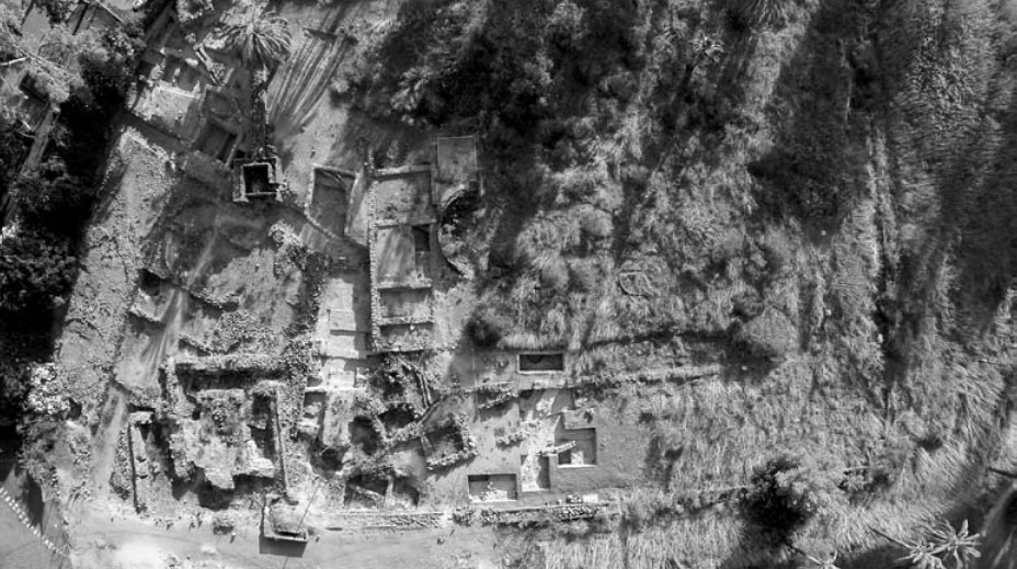 Figure 8.3
Parts of the palace [of al-Sinnabra] cleaned and partly re-excavated in 2009-2010. At center, the basilica apse and rooms to its south; looking west (photographed in 2015).
Da'adli (2017)
| Transliterated Name | Source | Name |
|---|---|---|
| Beth Yerah | Hebrew | בית ירח |
| Khirbet al-Karak | Arabic | خربة الكرك |
| Sennabris | Hebrew | סנבראי |
| al-Sinnabra | Hebrew | צינבריי ? |
| al-Sinnabra | Arabic | |
| Sinn en-Nabra | Arabic | سينن ينءنابرا |
| Philoteria | Ancient Greek | φιλοτέρα |
| Sennabris | Ancient Greek | |
| Sinnabri | Aramaic | |
| Senbra | Early Frankish | |
| Ablm-bt-Yrh | Canaanite | |
| Ablm | Canaanite |
- al-Sinnabra in Google Earth
 al-Sinnabra
click on image to explore this site on a new tab in Google Earth - al-Sinnabra on govmap.gov.il
 al-Sinnabra
click on image to explore this site on a new tab in govmap.gov.il
- Fig. 8.2 Detailed plan
of the al-Sinnabra palace from Da'adli (2017)
 Plan 8.2
Detailed plan of the al-Sinnabra palace
JW: Basilica is in the center surrounded by rectangular fortified walls and guard towers at the corners. Bathhouse is bottom right attached to the southern wall of the fort
Da'adli (2017) - Fig. 1 Areas excavated
at al-Sinnabra in 2007 and 2009 from Greenberg and Paz (2010)
 Figure 1
Aerial view of the 2007 excavation area, looking south.
Greenberg and Paz (2010)
- Fig. 8.2 Detailed plan
of the al-Sinnabra palace from Da'adli (2017)
Plan 8.2
Detailed plan of the al-Sinnabra palace
JW: Basilica is in the center surrounded by rectangular fortified walls and guard towers at the corners. Bathhouse is bottom right attached to the southern wall of the fort
Da'adli (2017) - Fig. 1 Areas excavated
at al-Sinnabra in 2007 and 2009 from Greenberg and Paz (2010)
Figure 1
Aerial view of the 2007 excavation area, looking south.
Greenberg and Paz (2010)
- Fig. 1.2 Fault
map of Tel Bet Yerah and vicinity from Greenberg et al. (2014:15)
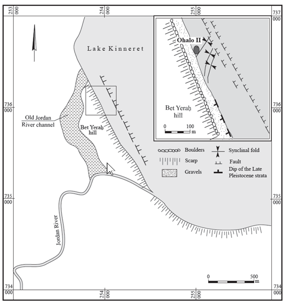 Fig. 1.2
Fault-lines observed near the site of Ohalo Hat the foot of Tel Bet Yerab (after Belitsky and Nadel 2002).
click on image to explore this image in a new tab
Greenberg et al. (2014) - Fig. 2.1 Early Bronze I Sites
from Greenberg (2019)
 Fig. 2.1
Map of sites mentioned in this chapter
Greenberg (2019) - Fig. 3.1 Early Bronze II and III Sites
from Greenberg (2019)
 Fig. 3.1
Map of sites mentioned in this chapter
Greenberg (2019) - Fig. 4.1 Intermediate Bronze Sites
from Greenberg (2019)
 Fig. 4.1
Map of sites mentioned in this chapter
Greenberg (2019) - Fig. 5.2 Middle Bronze Sites
from Greenberg (2019)
 Fig. 5.2
Map of sites mentioned in this chapter
Greenberg (2019) - Fig. 6.1 Late Bronze Sites
from Greenberg (2019)
 Fig. 6.1
Map of sites mentioned in this chapter
Greenberg (2019)
- Fig. 1.2 Fault
map of Tel Bet Yerah and vicinity from Greenberg et al. (2014:15)
Fig. 1.2
Fault-lines observed near the site of Ohalo Hat the foot of Tel Bet Yerab (after Belitsky and Nadel 2002).
click on image to explore this image in a new tab
Greenberg et al. (2014) - Fig. 2.1 Early Bronze I Sites
from Greenberg (2019)
Fig. 2.1
Map of sites mentioned in this chapter
Greenberg (2019) - Fig. 3.1 Early Bronze II and III Sites
from Greenberg (2019)
Fig. 3.1
Map of sites mentioned in this chapter
Greenberg (2019) - Fig. 4.1 Intermediate Bronze Sites
from Greenberg (2019)
Fig. 4.1
Map of sites mentioned in this chapter
Greenberg (2019) - Fig. 5.2 Middle Bronze Sites
from Greenberg (2019)
Fig. 5.2
Map of sites mentioned in this chapter
Greenberg (2019) - Fig. 6.1 Late Bronze Sites
from Greenberg (2019)
Fig. 6.1
Map of sites mentioned in this chapter
Greenberg (2019)
- Beth Yerah in Google Earth
Beth Yerah
click on image to explore this site on a new tab in Google Earth - Beth Yerah on govmap.gov.il
Beth Yerah
click on image to explore this site on a new tab in govmap.gov.il
 Plan 1
Map of the principal excavation areas (see Table 1 for area codes).
Greenberg et al. (2006)
 Table 1
Conspectus of Major archaeological Campaigns at Tel Bet Yerah since 1933
Greenberg et al. (2006)
- Fig. 1.5 Modern
topography of Tel Bet Yerah from Greenberg et al. (2014:15)
 Fig. 1.5
Modern topography of Tel Bet Yerah, based on surveys of the 1940s and 1950s.
click on image to explore this image in a new tab
Greenberg et al. (2014) - Fig. 1.6 Reconstructed
topography of the natural mound, with line of Wall A (Period C) superimposed on it from Greenberg et al. (2014:15)
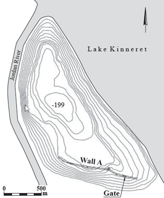 Fig. 1.6
Reconstructed topography of the natural mound, with line of Wall A (Period C) superimposed on it.
click on image to explore this image in a new tab
Greenberg et al. (2014) - Fig. 1.10 Contour
map of Tel Bet Yerah showing extent of Period A and B settlement from Greenberg et al. (2014:15)
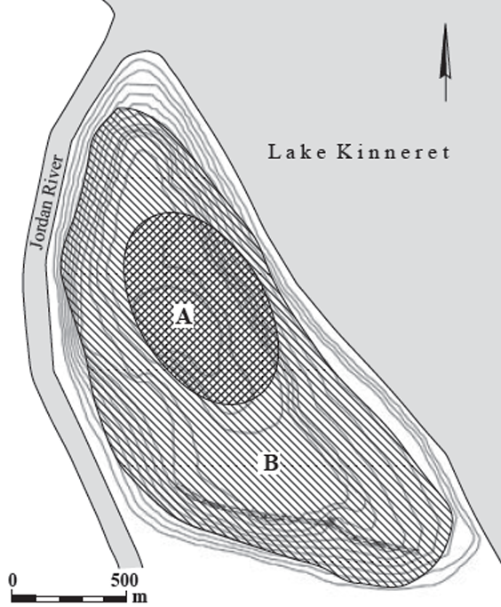 Fig. 1.10
Contour map of Tel Bet Yerah showing extent of Period A and B settlement.
click on image to explore this image in a new tab
Greenberg et al. (2014) - Fig. 1.12 Modern
contour map of Tel Bet Yerah with superimposed late Period D fortification from Greenberg et al. (2014:15)
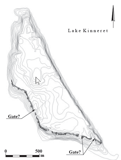 Fig. 1.12
Modern contour map of Tel Bet Yerah; with superimposed late Period D fortification, accentuating the shift of architectural mass toward the southern and western flanks of the mound, at the expense of the old acropolis.
click on image to explore this image in a new tab
Greenberg et al. (2014)
- Fig. 1.5 Modern
topography of Tel Bet Yerah from Greenberg et al. (2014:15)
Fig. 1.5
Modern topography of Tel Bet Yerah, based on surveys of the 1940s and 1950s.
click on image to explore this image in a new tab
Greenberg et al. (2014) - Fig. 1.6 Reconstructed
topography of the natural mound, with line of Wall A (Period C) superimposed on it from Greenberg et al. (2014:15)
Fig. 1.6
Reconstructed topography of the natural mound, with line of Wall A (Period C) superimposed on it.
click on image to explore this image in a new tab
Greenberg et al. (2014) - Fig. 1.10 Contour
map of Tel Bet Yerah showing extent of Period A and B settlement from Greenberg et al. (2014:15)
Fig. 1.10
Contour map of Tel Bet Yerah showing extent of Period A and B settlement.
click on image to explore this image in a new tab
Greenberg et al. (2014) - Fig. 1.12 Modern
contour map of Tel Bet Yerah with superimposed late Period D fortification from Greenberg et al. (2014:15)
Fig. 1.12
Modern contour map of Tel Bet Yerah; with superimposed late Period D fortification, accentuating the shift of architectural mass toward the southern and western flanks of the mound, at the expense of the old acropolis.
click on image to explore this image in a new tab
Greenberg et al. (2014)
- Plan 6.1 Tel Bet Yerah
fortification walls from Greenberg et al. (2006)
 Plan 6.1
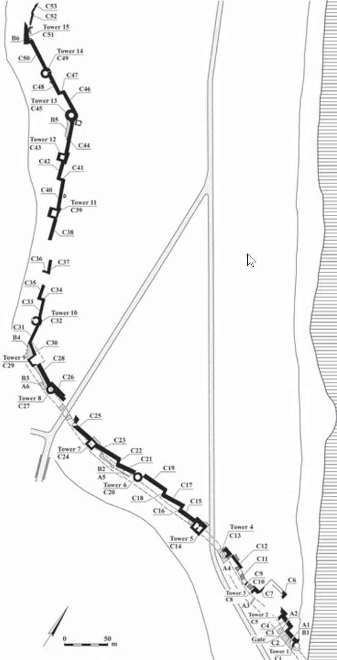
Key plan of the Tel Bet Yerah fortifications; Walls A and B shaded gray, Wall C in black, modern roads hatched.
click on image to explore this image in a new tab
Greenberg et al. (2006) - Plan 6.2 Segments A1,
A2 and the gate passage in Phase 1 from Greenberg et al. (2006)
 Plan 6.2
Wall A: Segments A1, A2 and the gate passage, Phase 1.
click on image to explore this image in a new tab
Greenberg et al. (2006) - Plan 6.4 Wall A and
the gate passage in Phase 2 from Greenberg et al. (2006)
 Plan 6.4
Wall A and the gate passage, Phase 2.
click on image to explore this image in a new tab
Greenberg et al. (2006) - Plan 6.5 Wall A,
Wall B, and the gate passage in Phase 3 from Greenberg et al. (2006)
 Plan 6.5
Wall A, Wall B, and the gate passage in Phase 3.
click on image to explore this image in a new tab
Greenberg et al. (2006)
- Plan 6.1 Tel Bet Yerah
fortification walls from Greenberg et al. (2006)
Plan 6.1
Key plan of the Tel Bet Yerah fortifications; Walls A and B shaded gray, Wall C in black, modern roads hatched.
click on image to explore this image in a new tab
Greenberg et al. (2006) - Plan 6.2 Segments A1,
A2 and the gate passage in Phase 1 of Wall A from Greenberg et al. (2006)
Plan 6.2
Wall A: Segments A1, A2 and the gate passage, Phase 1.
click on image to explore this image in a new tab
Greenberg et al. (2006) - Plan 6.4 Wall A and
the gate passage in Phase 2 from Greenberg et al. (2006)
Plan 6.4
Wall A and the gate passage, Phase 2.
click on image to explore this image in a new tab
Greenberg et al. (2006) - Plan 6.5 Wall A,
Wall B, and the gate passage in Phase 3 from Greenberg et al. (2006)
Plan 6.5
Wall A, Wall B, and the gate passage in Phase 3.
click on image to explore this image in a new tab
Greenberg et al. (2006)
- Fig. 6.8 Possible inner
threshold of Phase 1 gate of Wall A in sounding beneath Phase 2 pavement from Greenberg et al. (2006)
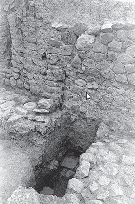 Fig. 6.8
Possible inner threshold of Phase 1 gate in sounding beneath Phase 2 pavement, looking northeast.
click on image to explore this image in a new tab
Greenberg et al. (2006)
- Fig. 6.8 Possible inner
threshold of Phase 1 gate of Wall A in sounding beneath Phase 2 pavement from Greenberg et al. (2006)
Fig. 6.8
Possible inner threshold of Phase 1 gate in sounding beneath Phase 2 pavement, looking northeast.
click on image to explore this image in a new tab
Greenberg et al. (2006)
 Table 2
Summary Table of Local Strata and archaeological periods in principal Excavation areas
Greenberg et al. (2006)
- Fig. 8.2 Detailed plan
of the al-Sinnabra palace from Da'adli (2017)
Plan 8.2
Detailed plan of the al-Sinnabra palace
JW: Basilica is in the center surrounded by rectangular fortified walls and guard towers at the corners. Bathhouse is bottom right attached to the southern wall of the fort
Da'adli (2017) - Fig. 1 Areas excavated
at al-Sinnabra in 2007 and 2009 from Greenberg and Paz (2010)
Figure 1
Aerial view of the 2007 excavation area, looking south.
Greenberg and Paz (2010)
The principal post-Bronze Age structure exposed on the site comprises a fort enclosing a basilical building, with a bathhouse attached to the enclosure's southern wall( Da'adli, 2017: 125 ). In addition, there are some ancillary structures outside the fort. Excavations undertaken in the 1950's
established a seventh-century CE terminus post quem for the central fortified structure and an eighth-century CE terminus post quem for the bathhouse(Da'adli, 2017 citing Greenberg and Paz, 2010). Based on historical sources, the Qasr was first constructed between 639 and 680 CE (Da'adli, 2017:126).
Chronological Evidence from Da'adli (2017) indicates occupation at the Qasr at least into the first half of the 8th century and later in ancillary structures (e.g. the Dar).
| Location | Page | Discussion |
|---|---|---|
| Basilica | 147-153 | A limited number of mosaics were found in the Basilica; some of which were defaced (Iconoclasm)
suggesting occupation which is dated to the 1st half of the 8th centurynote. |
| Southern Annex |
156-157 | Wall 162 (excavated in 2013 as W1698): A wall connecting Tower 2 and the southern addition was first excavated in 1950. As revealed in the 2009 and 2013 excavations, Channel GB 156 (excavated in 2013 as SA 1699) [part of the water system] was built into this wall, which did not have deep foundations. We may therefore assume that both the wall and the channel belong to the renovation phase of the southern annex (Fig. 8.30; Plan 8.8). A post-reform Umayyad coin (Chapter 9: Cat. No. 14) was found in the channel in 2013. The post-reform coin from Channel GB 156/SA 1699 indicates the period of use. Sanchez (2015:324) in Erdkamp, (2015) dates Umayyad post reform fals to after 696/700 CE. |
| Channel GB 159 (the water system} |
158-159 | In addition to the post-reform coin described above, from Channel GB 156/SA 1699, an oil lamp was found in one of the short drainage channels (GB 5; Fig. 8.37; see Plan 8.2); it is described as mold-decorated and the excavator proposed an "Arab" date. A complete lamp found in the IAA storerooms may be the artifact in question (see Fig. 8.60:4). This lamp type is dated to the sixth-eighth centuries CE at Jerash, while it was in use until the beginning of the ninth century CE elsewhere (Hadad 2002:68-71). Near Channel GB 5 and W4 a buff handle dated to the eighth—eleventh centuries CE was found (Fig. 8.60:3; Stacey 2004:130-132). The rim of a white-painted gray bag-shaped storage jar, dated to the fifth-eighth centuries CE, was discovered in a pit just north of the southern fortification wall (Fig. 8.60:5; Stacey 2004:126). The excavations of 2009-2010 within the enclosure yielded a mere handful of small ceramic fragments, all of either buff-ware or white-splashed jars. |
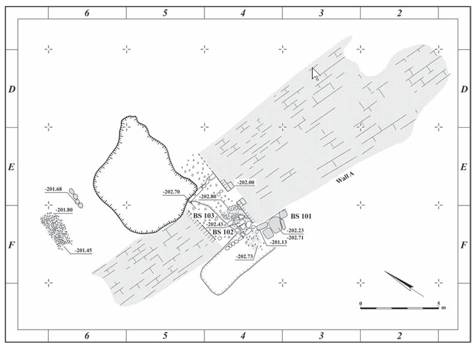
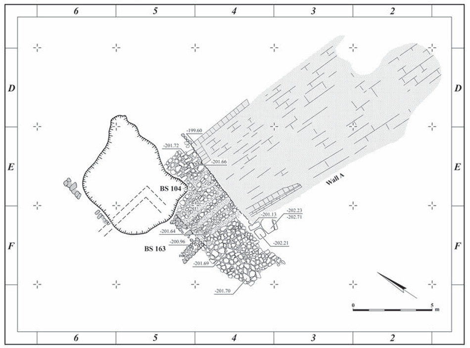
| Western Annex |
157 | Three rectangular rooms were uncovered on the western side of the basilica, numbered GB 102, GB 103 and GB 104, from north to south (see Plan 8.2). A small rectangular room abuts the western wall of Room GB 102. Channel GB 160 [the water system] splits off from Channel GB 159 [the water system] and enters the annex to Room GB 102 from the south, exiting through its western wall. The channel and the walls appear to have been built together, in a single stage (Fig. 8.32). Glazed pottery was found 0.1 m below the top of the walls in Room GB 103. Walmsley (2013:52) states that glazed wares, in Syria-Palestine [were] generally not introduced until the later eighth century at the earliest [and] always represented a small minority in the ceramic assemblage throughout the early Islamic period |
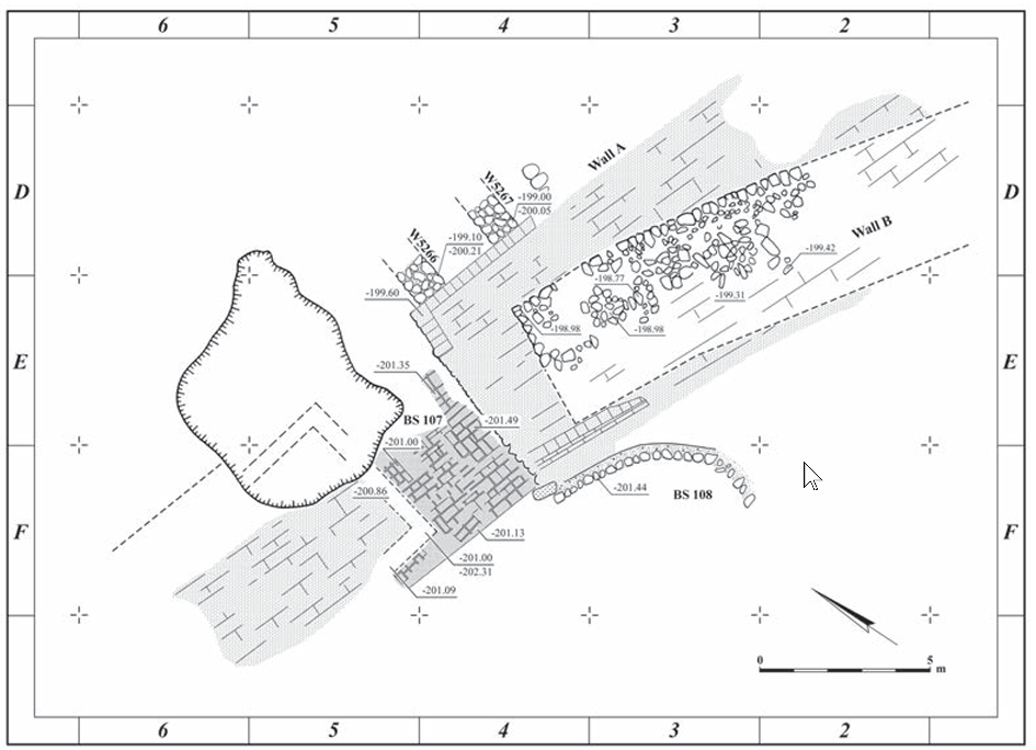
| Eastern and Northern Annex |
157 | A stylobate (W51) running parallel to the eastern side of the basilical structure supports a series of built pillar bases (0.9 x 0.6 m), placed at somewhat irregular intervals (2.55, 2.75, 2.80, 2.90 m; Fig. 8.33). This wall is built in the same method as the southern addition.12 note 12 - The excavator thought the southern rooms and stylobate to be Roman in date. Furthermore, the excavator writes that W19 was built in a different method, and that it is earlier than W51. On May 17,1950, a bronze coin was reported near W51, probably Cat. No. 21 in Chapter 9 - an Umayyad post-reform fals. Sanchez (2015:324) in Erdkamp, (2015) dates Umayyad post reform fals to after 696/700 CE. |
| Bathhouse | 169 | Finds from the bathhouse include two Umayyad coins found on the floor of the main hall (Maisler, Stekelis and Avi-Yonah 1952:222) and a chlorite vessel of eighth—tenth-century CE type (Stacey 2004:94) found near the western wall of the bathhouse (Fig. 8.60:6). During the 2009 excavation season, a portion of the northern wall of the frigidarium, which is in effect part of the curtain wall of the fortified enclosure, was sectioned. An Umayyad post-reform coin was found inside the core of the wall (Chapter 9: Cat. No. 15), apparently providing a terminus post quem for both the bath and the fortification. Sanchez (2015:324) in Erdkamp, (2015) dates Umayyad post reform fals to after 696/700 CE. |
| Kilns | 169 | Glass slag as well as a glazed ring-base was found inside Kiln GB 73. |
| Dar Unit | 171 | Isolated from the main enclosure and the bathhouse, another building or unit was exposed by Delougaz to the north of the fortified enclosure, above the remains of the tri-apsidal Byzantine church. |
| Location | Page | Discussion |
|---|---|---|
| 2-3 rooms over the bathhouse | 171 | A green glazed rim was found near W1 in Sq 02, which is on the eastern side of the wall. During the cleaning of the walls, an Islamic coin was discovered.21 note 21 - Description from December 25, 1945. A coin marked 25/2 or 2512, of Mamluk date, may be the one noted in the diary. See Chapter 9: Cat. No. 29. |
the historical record offers more details, at this point, than those provided by archaeology(Da'adli, 2017:175). However, the archaeology is in agreement with 7th and 8th century dates (Da'adli, 2017:175)).
the earliest material that can be associated with the fortified structure, ceramic, numismatic or otherwise, is consistently attributable to the seventh and eighth centuries CE. This includes the few ceramics—white-painted gray bag-shaped storage jars, buff-ware jugs with plastic knobs attached to the handle, and the molded lamp (Avissar 1996:147-149, 157; Haddad 2002:68-71), the chlorite bowl (Stacey 2004:94) and about 15 coins (see Chapter 9).The iconophobic defacing of mosaics in the Basilica was dated by Da'adli (2017:176) to the mid 8th century CE which suggests a date for the final renovation of the palace. Although historical sources indicate different phases of settlement at al-Sinnabra,
there is little surviving archeological evidencefor this (Da'adli, 2017:176). However, there may be
more facilites or sections that once were part of a palatial complexthat await excavation - e.g. between the Fort and the Dar (Da'adli, 2017:176).
One later structure was a
tower (Tower 12) and adjoining fortification walls extending east and northwhich was described by Da'adli (2017:176).
This unit could be part of some kind of citadel that may have had more towers and walls to the north and east. These might be Ayyubid in date, but hard evidence for such a date is lacking. The manner in which they overlie the earlier remains shows that the earlier, palatial structure was largely dismantled in antiquity.
- from Fall et al. (2023)
 Table 1
Traditional and revised Early and Middle Bronze Age chronologies for the Southern Levant. (Traditional chronology based on Dever 1992; Levy 1995:fig. 3; revised chronology based on Regev et al. 2012; Fall et al. 2021; Höflmayer and Manning 2022.)
Fall et al. (2023)
The data concerning Period C in various parts of the mound are contradictory and confused. This has to do to some extent with the quality of documentation and stratigraphic control in many of the older excavations, but perhaps, to a greater extent, with the intense sequence of construction characterizing the mound in EB II and EB III. In areas where the stratigraphy was best recorded, the average thickness of each phase was little more than 0.2 m. This means that each rebuild razed earlier remains to within a few centimeters of their floors. Table 1.2 and the description of the Period C strata present, therefore, the best approximation based on present data.
The construction of Wall A across the southern flank of the Tel Bet Yerah peninsula constitutes a turning point in the mound's physical history and in its presence in the landscape. The construction of the massive fortification, eventually attaining a breadth of 8 m and a commensurate height (perhaps 5–7 m), and of the gateway (gateways?) associated with it, created a new focus of settlement, rivaling the long-established center located on the summit of the mound. Indeed, the different sequences of accumulation evidenced at different parts of the mound seem to suggest that occupation and construction were more intense in both the north and south than in the intervening area, with a particularly swift build-up observed adjacent to Wall A, in Areas BS and MS. This build-up led eventually to the creation of a shallow depression inside the southern end of the mound, bordered on the one hand by the original slope of the mound, and on the other by the deposits built up against the wall on the south. This shallow depression eventually became more deeply incised, draining the mound through a break (gate?) in the later Early Bronze Age wall (Wall C) near the southwestern corner of the mound (below, Fig. 1.12). The erosion engendered by the depression and its extensions may be responsible for the absence of some Early Bronze Age strata in the area lying 100–200 m north of Wall A (the absence of Early Bronze strata at the northern end of their respective, parallel excavations is apparent in the sections drawn both by Makhouly [Bet Yerah I: Plan 9:2] and Getzov [2006: Fig. 1:1]). It cannot, however, have compromised Period C layers in locations further north, such as Areas UN and BH. These tend to be significantly shallower and stratigraphically poorer than the corresponding deposits in Areas SA, MS/EY, or BS, and could well indicate that the Period C settlement was not as evenly spread over the mound as that of Period B.
The presence of North Canaanite Metallic Ware as a significant component directly above Period B deposits in all areas of excavation suggests that the earliest part of Period C was that with the most intensive settlement. Indeed, the earliest phase of the gateway in Wall A indicates the existence of most elements in this wall early in Period C, and substantial stone-and-brick architecture can be found in every area excavated. As time wore on, the successive stages of reconstruction and repair appear to have affected a gradually diminishing portion of the mound, with intervening areas perhaps left in a state of abandonment or converted to intramural open spaces for use as gardens, livestock enclosures, or refuse dumps.
By the end of Period C, the houses nearest Wall A had been raised well above its foundations, forming a pronounced slope from the wall toward the interior of the town. To the observer approaching the town from the south (the only land approach possible), the tall scarp of Wall A and the cut that may well have fronted it (see Bet Yerah I: Chapter 6) would have dominated the skyline, rendering the original acropolis all but invisible. Upon entering the town through the southeastern gate, the visitor would have faced a maze of paved streets and alleys and only after pushing ahead for some minutes would he have been able to emerge into the open, gaining a view of the more widely spaced domestic compounds in the center of the mound and the important buildings that no doubt stood on its summit.
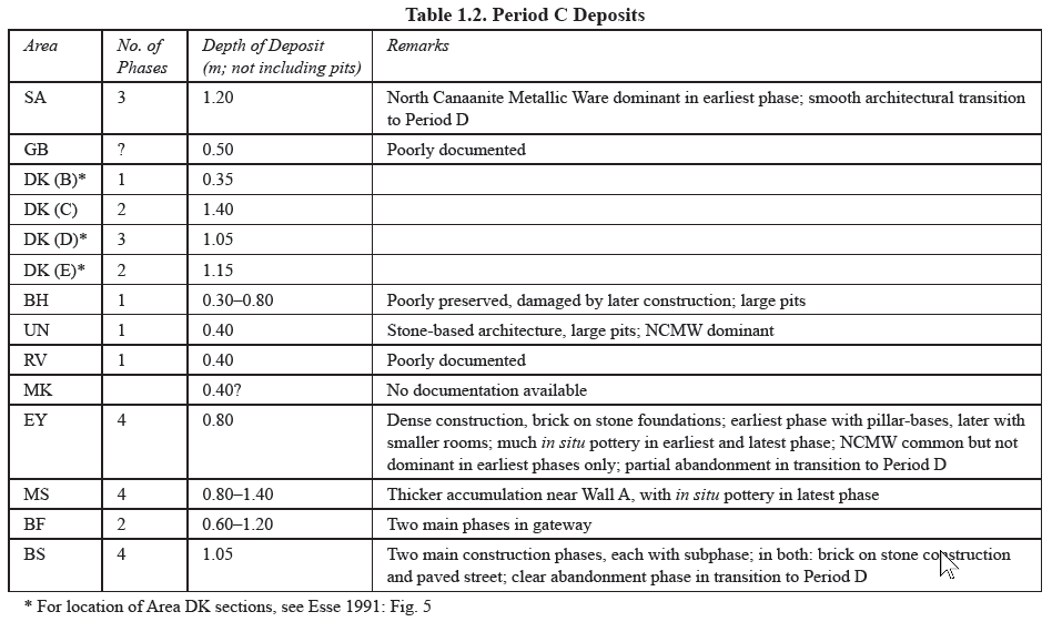 Table 1.2
Period C Deposits
Greenberg et al. (2014)
- Fig. 8.2 Detailed plan
of the al-Sinnabra palace from Da'adli (2017)
Plan 8.2
Detailed plan of the al-Sinnabra palace
JW: Basilica is in the center surrounded by rectangular fortified walls and guard towers at the corners. Bathhouse is bottom right attached to the southern wall of the fort
Da'adli (2017) - Fig. 1 Areas excavated
at al-Sinnabra in 2007 and 2009 from Greenberg and Paz (2010)
Figure 1
Aerial view of the 2007 excavation area, looking south.
Greenberg and Paz (2010)
In excavations which took place in 2007 and 2009, Greenberg and Paz (2010) identified what be a foundation crack at the Umayyad Qasr built by Mu'awiya I in Area GB-T
Area GB-T
A new aspect of the 2009 excavations is our attempt to re-excavate and reinterpret the huge fortified complex cleared by Bar-Adon and Guy in the early 1950s but never fully published. Originally identified as a synagogue and then as a Roman or Byzantine fort, the most recent suggestion has been to identify the complex with the Early Islamic palace of al-Sinnabra. The area has been obscured for decades by the thick subtropical vegetation that characterizes the mound. Because the structure was largely dismantled in antiquity, leaving only wall and floor foundations intact, and due to the summary excavation methods used in the original excavations, our principal aim was to identify sealed or otherwise datable contexts, such as foundation trenches and subfloor deposits. Additionally, the surviving portions of the superstructure had to be revisited and recorded.
Thus far, the southwest tower of the enceinte and parts of the southern annex adjoining the large apse have been reinvestigated, two large mosaic floor segments recorded (Fig. 12), and a portion of the central floorbed removed. Some preliminary observations may be made:We are therefore confident that the Umayyad palace of al-Sinnabra has been found.
- The original wall foundations of the external fortifications, the adjoining bathhouse, and the central structure are all equally massive and deep, indicating a high level of investment, similar building concepts in all parts of the complex, and the likelihood that the superstructure was quite substantial.
- There is multiple evidence for the existence of at least two building phases in the main structure. The later phase involved wall demolition and replacement, as well as repairs in the mosaic pavements.
- We have begun to see evidence of earthquake damage; this could eventually aid in the dating of the structure.
(Fig. 13).
Area GB-T, foundations in the southern part of the central palace structure; foundation trenches and evidence for earthquake damage in south wall (at right), looking south.
Greenberg and Paz (2010)- A second fortified enclosure was built over part of the main enclosure. This later enclosure was never reported by the excavators.
- Although finds are sparse, the Early Islamic dating does appear to be confirmed by coins found beneath the floor of the central hall and in the foundation trench of the bathhouse.
| Effect | Location | Image(s) | Description |
|---|---|---|---|
|
Wall A and various areas in the south of the Mound
Plan 1 Map of the principal excavation areas (see Table 1 for area codes). click on image to explore this image in a new tab Greenberg et al. (2006)
Plan 6.1Key plan of the Tel Bet Yerah fortifications; Walls A and B shaded gray, Wall C in black, modern roads hatched. click on image to explore this image in a new tab Greenberg et al. (2006)
Fig. 1.6Reconstructed topography of the natural mound, with line of Wall A (Period C) superimposed on it. click on image to explore this image in a new tab Greenberg et al. (2014)
Plan 6.2Wall A: Segments A1, A2 and the gate passage, Phase 1. click on image to explore this image in a new tab Greenberg et al. (2006)
Plan 6.4Wall A and the gate passage, Phase 2. click on image to explore this image in a new tab Greenberg et al. (2006)
Plan 6.5Wall A, Wall B, and the gate passage in Phase 3. click on image to explore this image in a new tab Greenberg et al. (2006) |
Fig. 6.8 Possible inner threshold of Phase 1 gate in sounding beneath Phase 2 pavement, looking northeast. click on image to explore this image in a new tab Greenberg et al. (2006) |
|
| Effect | Location | Image(s) | Description |
|---|---|---|---|
| Huge amounts of collapsed masonry | Tower 3
Plan 8.2 Detailed plan of the al-Sinnabra palace JW: Basilica is in the center surrounded by rectangular fortified walls and guard towers at the corners. Bathhouse is bottom right attached to the southern wall of the fort Da'adli (2017) |
|
|
| Foundation cracks | Wall W121
Plan 8.2 Detailed plan of the al-Sinnabra palace JW: Basilica is in the center surrounded by rectangular fortified walls and guard towers at the corners. Bathhouse is bottom right attached to the southern wall of the fort Da'adli (2017) |
 Figure 8.27
Room GB 34, looking south. Wall 122, left, lacks foundations, in contrast to W121 (center) and W120 (right). Scale is in foundation trench of the original eastern wall. Note large crack in right part of W121 (2009 excavations). In Greenberg and Paz (2010) the caption for this photo was: Area GB-T, foundations in the southern part of the central palace structure; foundation trenches and evidence for earthquake damage in south wall (at right), looking south. Da'adli (2017)  Figure 8.31
The southern face of W121, looking north. Note crack at right (2010 excavations). Da'adli (2017) |
|
| Missing Section of Wall | Umayyad Bathhouse
Plan 8.2 Detailed plan of the al-Sinnabra palace JW: Basilica is in the center surrounded by rectangular fortified walls and guard towers at the corners. Bathhouse is bottom right attached to the southern wall of the fort Da'adli (2017) |
Figure 8.3 Parts of the palace cleaned and partly re-excavated in 2009-2010. At center, the basilica apse and rooms to its south; looking west (photographed in 2015). Da'adli (2017) |
|
- Modified by JW from Plan 8.2 from Da'adli (2017)
 Deformation Map
Modified by JW from Plan 8.2 from Da'adli (2017)
-
Earthquake Archeological Effects chart
of Rodríguez-Pascua et al (2013: 221-224)
 Earthquake Archeological Effects (EAE)
Rodríguez-Pascua et al (2013: 221-224)
| Effect | Location | Image(s) | Description | Intensity |
|---|---|---|---|---|
|
Wall A and various areas in the south of the Mound
Plan 1 Map of the principal excavation areas (see Table 1 for area codes). click on image to explore this image in a new tab Greenberg et al. (2006)
Plan 6.1Key plan of the Tel Bet Yerah fortifications; Walls A and B shaded gray, Wall C in black, modern roads hatched. click on image to explore this image in a new tab Greenberg et al. (2006)
Fig. 1.6Reconstructed topography of the natural mound, with line of Wall A (Period C) superimposed on it. click on image to explore this image in a new tab Greenberg et al. (2014)
Plan 6.2Wall A: Segments A1, A2 and the gate passage, Phase 1. click on image to explore this image in a new tab Greenberg et al. (2006)
Plan 6.4Wall A and the gate passage, Phase 2. click on image to explore this image in a new tab Greenberg et al. (2006)
Plan 6.5Wall A, Wall B, and the gate passage in Phase 3. click on image to explore this image in a new tab Greenberg et al. (2006) |
Fig. 6.8 Possible inner threshold of Phase 1 gate in sounding beneath Phase 2 pavement, looking northeast. click on image to explore this image in a new tab Greenberg et al. (2006) |
|
|
-
Earthquake Archeological Effects chart
of Rodríguez-Pascua et al (2013: 221-224)
Earthquake Archeological Effects (EAE)
Rodríguez-Pascua et al (2013: 221-224)
| Effect | Location | Image(s) | Description | Intensity |
|---|---|---|---|---|
| Collapsed Walls - Huge amounts of collapsed masonry | Tower 3
Plan 8.2 Detailed plan of the al-Sinnabra palace JW: Basilica is in the center surrounded by rectangular fortified walls and guard towers at the corners. Bathhouse is bottom right attached to the southern wall of the fort Da'adli (2017) |
|
VIII + | |
| Foundation cracks | Wall W121
Plan 8.2 Detailed plan of the al-Sinnabra palace JW: Basilica is in the center surrounded by rectangular fortified walls and guard towers at the corners. Bathhouse is bottom right attached to the southern wall of the fort Da'adli (2017) |
Figure 8.27 Room GB 34, looking south. Wall 122, left, lacks foundations, in contrast to W121 (center) and W120 (right). Scale is in foundation trench of the original eastern wall. Note large crack in right part of W121 (2009 excavations). In Greenberg and Paz (2010) the caption for this photo was: Area GB-T, foundations in the southern part of the central palace structure; foundation trenches and evidence for earthquake damage in south wall (at right), looking south. Da'adli (2017)
Figure 8.31The southern face of W121, looking north. Note crack at right (2010 excavations). Da'adli (2017) |
|
|
| Collapsed Walls ? - Missing Section of Wall | Umayyad Bathhouse
Plan 8.2 Detailed plan of the al-Sinnabra palace JW: Basilica is in the center surrounded by rectangular fortified walls and guard towers at the corners. Bathhouse is bottom right attached to the southern wall of the fort Da'adli (2017) |
Figure 8.3 Parts of the palace cleaned and partly re-excavated in 2009-2010. At center, the basilica apse and rooms to its south; looking west (photographed in 2015). Da'adli (2017) |
|
VIII + |
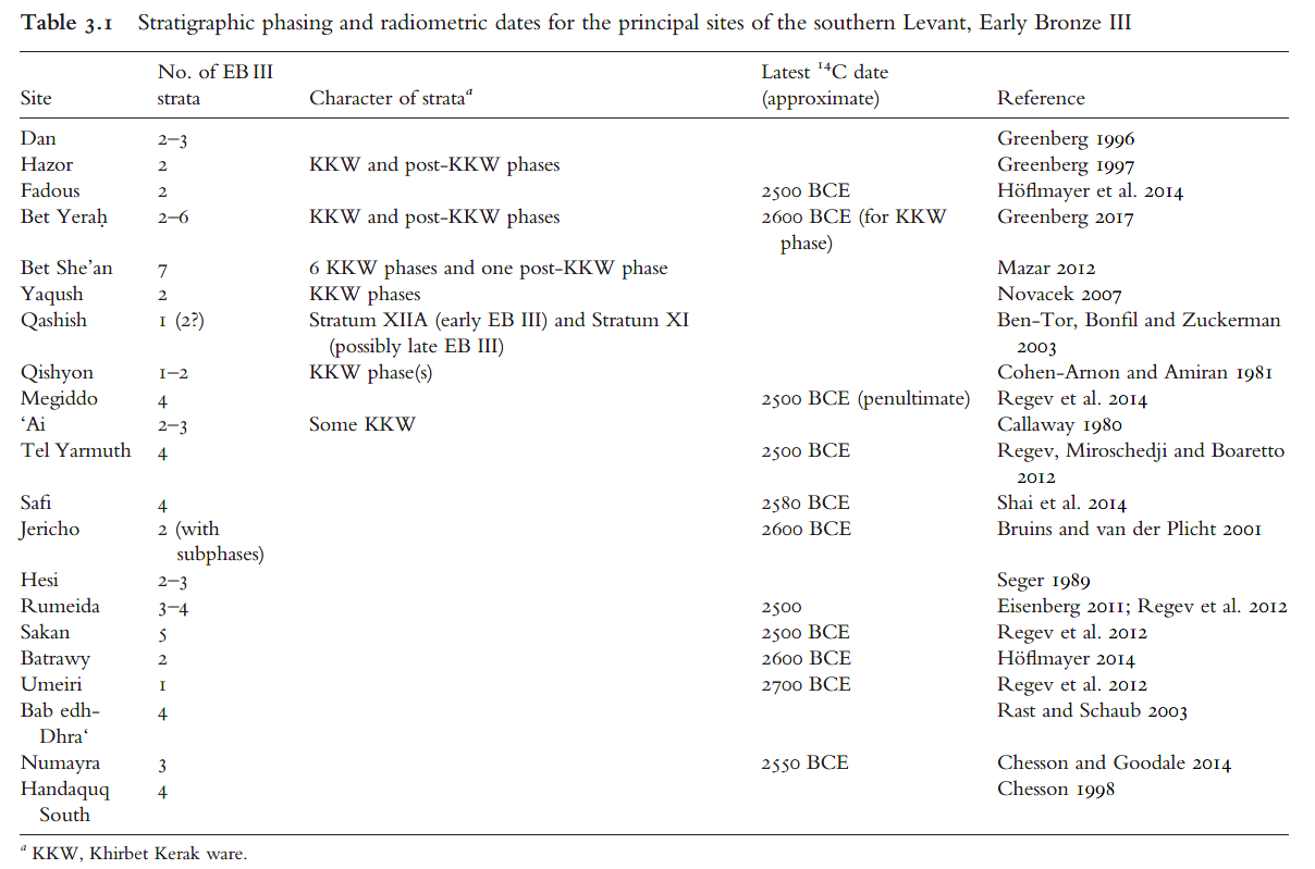 Table 3.1
Stratigraphic phasing and radiometric dates for the principal sites of the southern Levant, Early Bronze III
Greenberg (2019)