Jerash - Southwest Hill
 Jerash Southwest Hill
click on image to explore this site on a new tab in Google Earth
- from Blanke et al. (2015) describing the Late Antique Jarash Project (LAJP)
- Fig. 2 - Areas A-E of
the Late Antique Jarash Project (LAJP) from Blanke et al. (2015)
 Figure 2
Architectural remains on hilltop showing Areas A-E
© Louise Blanke and IJP (Islamic Jerash Project)
Blanke et al (2015) - Fig. 5 - Detail of hilltop
in southwest district showing location of Trenches 1-4 from Blanke et al (2021)
 Figure 5
Detail of hilltop in southwest district showing location of Trenches 1-4. © LAJP.
Blanke et al (2021)
- Fig. 2 - Areas A-E of
the Late Antique Jarash Project (LAJP) from Blanke et al. (2015)
Figure 2
Architectural remains on hilltop showing Areas A-E
© Louise Blanke and IJP (Islamic Jerash Project)
Blanke et al (2015) - Fig. 5 - Detail of hilltop
in southwest district showing location of Trenches 1-4 from Blanke et al (2021)
Figure 5
Detail of hilltop in southwest district showing location of Trenches 1-4. © LAJP.
Blanke et al (2021)
The southwest part of Jarash is characterised by a gradually rising landscape that slopes upwards west of the South Decumanus and the Umayyad congregational mosque towards the town wall. From the south, a series of terraces overlook the South Theatre. The hilltop is defined by a relatively flat area that measures some 100 by 80 metres at the summit of the main slope. The location of the hilltop at some distance from the major thoroughfares means that modern activity has largely been restricted to grazing goats and a partial conversion of the area to a football field. Tourists seldom make their way to the hill-top, partly owing to the steep climb and partly to the limited archaeological work conducted in this part of the town.
The occupational history of the hilltop and its immediate surroundings has been traced from the Hellenistic Period — where natural caves were modified to accommodate tombs — to the eighth century AD. The latter date was produced in the excavations of the Mortuary Church and the Church of St. Peter and St. Paul (built in the early 7th century (Gatier 1987: 135)) where it was defined through secondary architectural use and the discovery of two coins. When we began our survey, little was known of the periods between these two dates.
Our survey contained two main components. The first component entailed a comprehensive recording of the area between the mosque, the South Decumanus and the town wall where all visible wall lines, cisterns, previous excavated areas, bedrock cuts, terracing and dumps of excavated soil were recorded and mapped with a total station. These data were combined with excavation plans from the IJP [Islamic Jerash Project] using GIS (Geographical Information System) software and superimposed on a recent Google Earth image of the site. An aerial photo of Jarash from 1928 from the Yale University archive was used to trace land use and its impact on the archaeological landscape during the past 80 years.
The second component comprised a focused study of five adjoining areas, all located on the hilltop or immediately adjacent to its main features. These areas were first cleared of vegetation and, thereafter, recorded in detail, using written description combined with a full drawn and photographic record.
The five areas on the hilltop are (Fig. 2: A-E):
- A building on two levels and a cistern
- A plateau with a series of bedrock cuts
- A rectangular space, defined to the south and west by long, straight cuts into the bedrock
- A building complex with a cistern, located on the northern edge of the hilltop
- A street that runs from the South Decumanus to the hilltop
- Fig. 4.1 - Map of the
territories around Baysān/Scythopolis, Fiḥl/Pella and Jarash/Gerasa showing late Roman and early Islamic provincial structures from Blanke and Walmsley (2022)
 Figure 4.1
Map of the territories around Baysān/Scythopolis, Fiḥl/Pella and Jarash/Gerasa, showing late Roman and early Islamic provincial structures
(Alan Walmsley).
Blanke and Walmsley (2022)
- Fig. 4.1 - Map of the
territories around Baysān/Scythopolis, Fiḥl/Pella and Jarash/Gerasa showing late Roman and early Islamic provincial structures from Blanke and Walmsley (2022)
Figure 4.1
Map of the territories around Baysān/Scythopolis, Fiḥl/Pella and Jarash/Gerasa, showing late Roman and early Islamic provincial structures
(Alan Walmsley).
Blanke and Walmsley (2022)
- Fig. 1 - Aerial photo
showing southwest hill and surroundings from Blanke et al. (2015)
 Figure 1
1928 aerial photo from Yale University archive showing general survey area and hilltop.
Blanke et al (2015) - Jerash Southwest Hill in Google Earth
Jerash Southwest Hill
click on image to explore this site on a new tab in Google Earth
- Fig. 1 - Aerial photo
showing southwest hill and surroundings from Blanke et al. (2015)
Figure 1
1928 aerial photo from Yale University archive showing general survey area and hilltop.
Blanke et al (2015) - Jerash Southwest Hill in Google Earth
Jerash Southwest Hill
click on image to explore this site on a new tab in Google Earth
- General Plan of Jerash
from Wikipedia
- Fig. 2 - Plan of Umayyad
Jerash from Walmsley and Daamgaard (2005)

Figure 2
Plan summarising the principal urban features of Umayyad Jarash.
- Umayyad mosque
- possible Islamic administrative centre
- market (suq)
- South Tetrakonia piazza (built over)
- Macellum, with Umayyad–Abbasid rebuilding, and south cardo, encroached by structures;
- Oval piazza domestic quarter with fountain;
- Zeus temple forecourt (kiln, monastery?)
- hippodrome and Bishop Marianos church, eighth century use
- church of SS Peter and Paul and Mortuary Church (Umayyad construction date?)
- churches of SS Cosmas and Damianus, St George and St John theBaptist, with Umayyad–Abbasid occupation and iconoclastic-effected mosaics (later eighth century)
- Christian complex of two churches (Cathedral to the east with stairs from the street, St Theodore’s to the west), mid-5th to late 6th century Bath of Placcus (north of St Theodore’s) and houses west of St Theodore’s with extensive Umayyad occupation including a kiln and oil press
- Artemis compound used for ceramic manufacture
- Synagogue church with iconoclastic-effected mosaics
- North Theatre, also industrialised with kilns
- the 1981 ‘mosque’
- central Cardo with blacksmith’s shop and offices
Map modfied from R.E. Pillen in Zayadine (1986).
Walmsley and Daamgaard (2005) - Fig. 13 - Early Islamic
Jerash - 8th to 13th century CE - from Rattenborg and Blanke (2017)
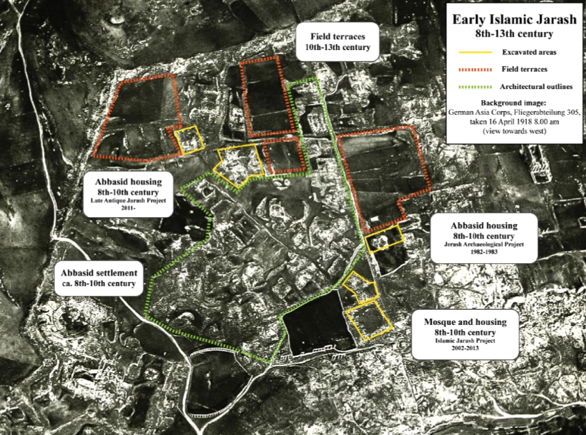 Figure 13
Early Islamic Jerash
8th to 13th century CE
Rattenborg and Blanke (2017)

- Fig. 2 - Plan of Umayyad
Jerash from Walmsley and Daamgaard (2005)
Figure 2
Plan summarising the principal urban features of Umayyad Jarash.
- Umayyad mosque
- possible Islamic administrative centre
- market (suq)
- South Tetrakonia piazza (built over)
- Macellum, with Umayyad–Abbasid rebuilding, and south cardo, encroached by structures;
- Oval piazza domestic quarter with fountain;
- Zeus temple forecourt (kiln, monastery?)
- hippodrome and Bishop Marianos church, eighth century use
- church of SS Peter and Paul and Mortuary Church (Umayyad construction date?)
- churches of SS Cosmas and Damianus, St George and St John theBaptist, with Umayyad–Abbasid occupation and iconoclastic-effected mosaics (later eighth century)
- Christian complex of two churches (Cathedral to the east with stairs from the street, St Theodore’s to the west), mid-5th to late 6th century Bath of Placcus (north of St Theodore’s) and houses west of St Theodore’s with extensive Umayyad occupation including a kiln and oil press
- Artemis compound used for ceramic manufacture
- Synagogue church with iconoclastic-effected mosaics
- North Theatre, also industrialised with kilns
- the 1981 ‘mosque’
- central Cardo with blacksmith’s shop and offices
Map modfied from R.E. Pillen in Zayadine (1986).
Walmsley and Daamgaard (2005) - Fig. 13 - Early Islamic
Jerash - 8th to 13th century CE - from Rattenborg and Blanke (2017)
Figure 13
Early Islamic Jerash
8th to 13th century CE
Rattenborg and Blanke (2017)
- Fig. 1 - Map of Jarash’s
southwest district from Blanke et al (2021)
 Figure 1
Map of Jarash’s southwest district with emphasis on survey area and the hilltop, which has so far been the focus of the excavations carried out by LAJP.
© LAJP.
Blanke et al (2021)
- Fig. 1 - Map of Jarash’s
southwest district from Blanke et al (2021)
Figure 1
Map of Jarash’s southwest district with emphasis on survey area and the hilltop, which has so far been the focus of the excavations carried out by LAJP.
© LAJP.
Blanke et al (2021)
- Fig. 3.4 Location of
Trenches in Jerash's south-west neighborhood from Blanke in Lichtenberger and Raja (2025)
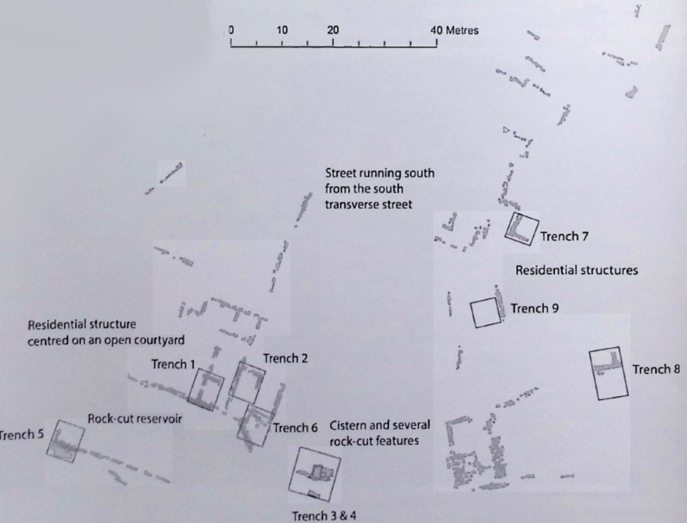 Figure 3.4
Location of Trenches in Jerash's south-west neighborhood
(Map by L/ Blanke and the Late Antique Jerash Project)
Click on image to open in a new tab
Blanke in Lichtenberger and Raja (2025) - Fig. 4.1 Maps of excavation
areas in the LAJP in 2025 and 2017 from Blanke in Lichtenberger and Raja (2025)
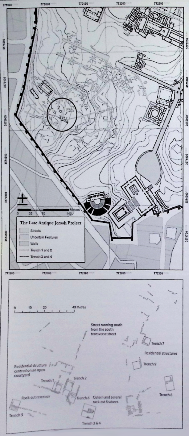 Figure 4.1
Maps of excavation areas in the LAJP in 2025 and 2017
(image: Late Antique Jerash Project)
Click on image to open in a new tab
Blanke in Lichtenberger and Raja (2025) - Fig. 2 - Areas A-E of
the Late Antique Jarash Project (LAJP) from Blanke et al. (2015)
Figure 2
Architectural remains on hilltop showing Areas A-E
© Louise Blanke and IJP (Islamic Jerash Project)
Blanke et al (2015) - Fig. 5 - Detail of hilltop
in southwest district showing location of Trenches 1-4 from Blanke et al (2021)
Figure 5
Detail of hilltop in southwest district showing location of Trenches 1-4. © LAJP.
Blanke et al (2021) - Fig. 2 - Survey map
showing location of Trench 5-9 on the southwest hilltop from Blanke et al. (2024)
 Figure 2
Survey map showing location of Trench 5-9 on the southwest hilltop
© LAJP.
Blanke et al. (2024)
- Fig. 3.4 Location of
Trenches in Jerash's south-west neighborhood from Blanke in Lichtenberger and Raja (2025)
Figure 3.4
Location of Trenches in Jerash's south-west neighborhood
(Map by L/ Blanke and the Late Antique Jerash Project)
Click on image to open in a new tab
Blanke in Lichtenberger and Raja (2025) - Fig. 4.1 Maps of excavation
areas in the LAJP in 2025 and 2017 from Blanke in Lichtenberger and Raja (2025)
Figure 4.1
Maps of excavation areas in the LAJP in 2025 and 2017
(image: Late Antique Jerash Project)
Click on image to open in a new tab
Blanke in Lichtenberger and Raja (2025) - Fig. 2 - Areas A-E of
the Late Antique Jarash Project (LAJP) from Blanke et al. (2015)
Figure 2
Architectural remains on hilltop showing Areas A-E
© Louise Blanke and IJP (Islamic Jerash Project)
Blanke et al (2015) - Fig. 5 - Detail of hilltop
in southwest district showing location of Trenches 1-4 from Blanke et al (2021)
Figure 5
Detail of hilltop in southwest district showing location of Trenches 1-4. © LAJP.
Blanke et al (2021) - Fig. 2 - Survey map
showing location of Trench 5-9 on the southwest hilltop from Blanke et al. (2024)
Figure 2
Survey map showing location of Trench 5-9 on the southwest hilltop
© LAJP.
Blanke et al. (2024)
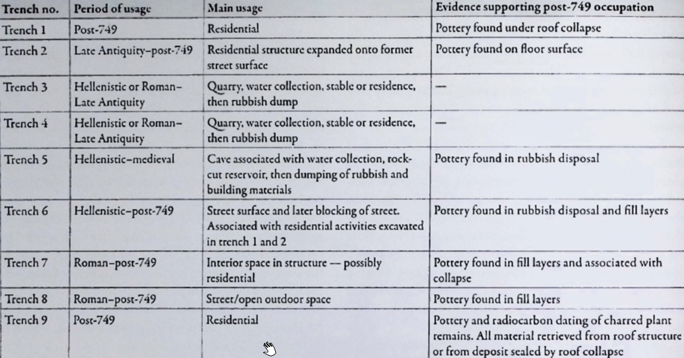 Table 3.1
Overview of the Late Antique Jerash Project's nine excavation trenches and their main periods of usage
Click on image to open in a new tab
Blanke in Lichtenberger and Raja (2025)
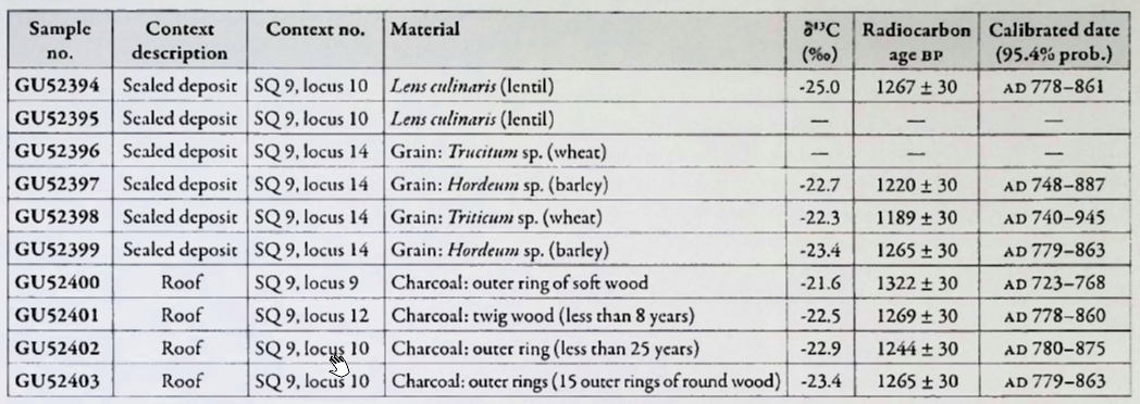 Table 3.2
Overview of radiocarbon samples and results.
Click on image to open in a new tab
Blanke in Lichtenberger and Raja (2025)
- Fig. 7 - Pottery crushed
by late 9th/early 10th century CE earthquake (in Trench 1) from Blanke et al. (2021)
 Figure 7
Remains of two ceramic pithoi embedded into the construction of the floor.
© LAJP
Blanke et al (2021) - Fig. 8 - Blocked Doorway
in Wall1 of Trench 2 from Blanke et al. (2021)
 Figure 8
Trench 2 showing Wall 1 with blocked doorway. View towards the west
© LAJP
Blanke et al (2021) - Fig. 3.6 Trench 9 after
excavation showing prayer platform and possible stone fractures from Lichtenberger and Raja (2025)
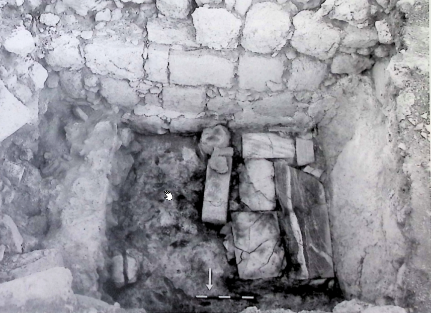 Figure 3.6
Trench 9 after excavation showing prayer platform in the room's south-west corner. Note vertical bedrock cut in the right side of the photo and remains of moulded plaster on south wall
JW: Some stones show possible fractures from impact of falling objects
(photo by the Late Antique Jerash Project)
Click on image to open in a new tab
Lichtenberger and Raja (2025)
- Fig. 7 - Pottery crushed
by late 9th/early 10th century CE earthquake (in Trench 1) from Blanke et al. (2021)
Figure 7
Remains of two ceramic pithoi embedded into the construction of the floor.
© LAJP
Blanke et al (2021) - Fig. 8 - Blocked Doorway
in Wall1 of Trench 2 from Blanke et al. (2021)
Figure 8
Trench 2 showing Wall 1 with blocked doorway. View towards the west
© LAJP
Blanke et al (2021) - Fig. 3.6 Trench 9 after
excavation showing prayer platform and possible stone fractures from Lichtenberger and Raja (2025)
Figure 3.6
Trench 9 after excavation showing prayer platform in the room's south-west corner. Note vertical bedrock cut in the right side of the photo and remains of moulded plaster on south wall
JW: Some stones show possible fractures from impact of falling objects
(photo by the Late Antique Jerash Project)
Click on image to open in a new tab
Lichtenberger and Raja (2025)
- Fig. 4 - Interpretation
of magnetic data (shows roads) from Blanke et al (2021)
 Figure 4
Interpretation of magnetic data from prospection of Jarash’s southwest district.
© LAJP.
Blanke et al (2021)
- Fig. 4 - Interpretation
of magnetic data (shows roads) from Blanke et al (2021)
Figure 4
Interpretation of magnetic data from prospection of Jarash’s southwest district.
© LAJP.
Blanke et al (2021)
| Effect | Location | Image(s) | Description |
|---|---|---|---|
|
Trench 7 Figure 4.1
Maps of excavation areas in the LAJP in 2025 and 2017 (image: Late Antique Jerash Project) Click on image to open in a new tab Blanke in Lichtenberger and Raja (2025)
Figure 3.4
Location of Trenches in Jerash's south-west neighborhood (Map by L/ Blanke and the Late Antique Jerash Project) Click on image to open in a new tab Blanke in Lichtenberger and Raja (2025) |
|
|
|
Trench 9
Figure 4.1
Maps of excavation areas in the LAJP in 2025 and 2017 (image: Late Antique Jerash Project) Click on image to open in a new tab Blanke in Lichtenberger and Raja (2025)
Figure 3.4
Location of Trenches in Jerash's south-west neighborhood (Map by L/ Blanke and the Late Antique Jerash Project) Click on image to open in a new tab Blanke in Lichtenberger and Raja (2025) |
|
| Effect | Location | Image(s) | Description |
|---|---|---|---|
|
Storeroom located in the southern part of Area D residential building opening onto a courtyard - Trench 1
Figure 4.1
Maps of excavation areas in the LAJP in 2025 and 2017 (image: Late Antique Jerash Project) Click on image to open in a new tab Blanke in Lichtenberger and Raja (2025)
Figure 3.4
Location of Trenches in Jerash's south-west neighborhood (Map by L/ Blanke and the Late Antique Jerash Project) Click on image to open in a new tab Blanke in Lichtenberger and Raja (2025) Architectural remains on hilltop showing Areas A-E © Louise Blanke and IJP (Islamic Jerash Project) Blanke et al (2015) |
Remains of two ceramic pithoi embedded into the construction of the floor. © LAJP Blanke et al (2021) |
|
- Earthquake Archeological Effects chart
of Rodríguez-Pascua et al (2013: 221-224)
 Earthquake Archeological Effects (EAE)
Rodríguez-Pascua et al (2013: 221-224)
| Effect | Location | Image(s) | Description | Intensity |
|---|---|---|---|---|
|
Trench 7
Figure 4.1
Maps of excavation areas in the LAJP in 2025 and 2017 (image: Late Antique Jerash Project) Click on image to open in a new tab Blanke in Lichtenberger and Raja (2025)
Figure 3.4
Location of Trenches in Jerash's south-west neighborhood (Map by L/ Blanke and the Late Antique Jerash Project) Click on image to open in a new tab Blanke in Lichtenberger and Raja (2025) |
|
|
|
|
Trench 9
Figure 4.1
Maps of excavation areas in the LAJP in 2025 and 2017 (image: Late Antique Jerash Project) Click on image to open in a new tab Blanke in Lichtenberger and Raja (2025)
Figure 3.4
Location of Trenches in Jerash's south-west neighborhood (Map by L/ Blanke and the Late Antique Jerash Project) Click on image to open in a new tab Blanke in Lichtenberger and Raja (2025) |
|
|
- Earthquake Archeological Effects chart
of Rodríguez-Pascua et al (2013: 221-224)
Earthquake Archeological Effects (EAE)
Rodríguez-Pascua et al (2013: 221-224)
| Effect | Location | Image(s) | Description | Intensity |
|---|---|---|---|---|
|
Storeroom located in the southern part of Area D residential building opening onto a courtyard - Trench 1
Figure 4.1
Maps of excavation areas in the LAJP in 2025 and 2017 (image: Late Antique Jerash Project) Click on image to open in a new tab Blanke in Lichtenberger and Raja (2025)
Figure 3.4
Location of Trenches in Jerash's south-west neighborhood (Map by L/ Blanke and the Late Antique Jerash Project) Click on image to open in a new tab Blanke in Lichtenberger and Raja (2025) Architectural remains on hilltop showing Areas A-E © Louise Blanke and IJP (Islamic Jerash Project) Blanke et al (2015) |
Remains of two ceramic pithoi embedded into the construction of the floor. © LAJP Blanke et al (2021) |
|
|


