Jerash (aka Gerasa) - Introduction
APAAME
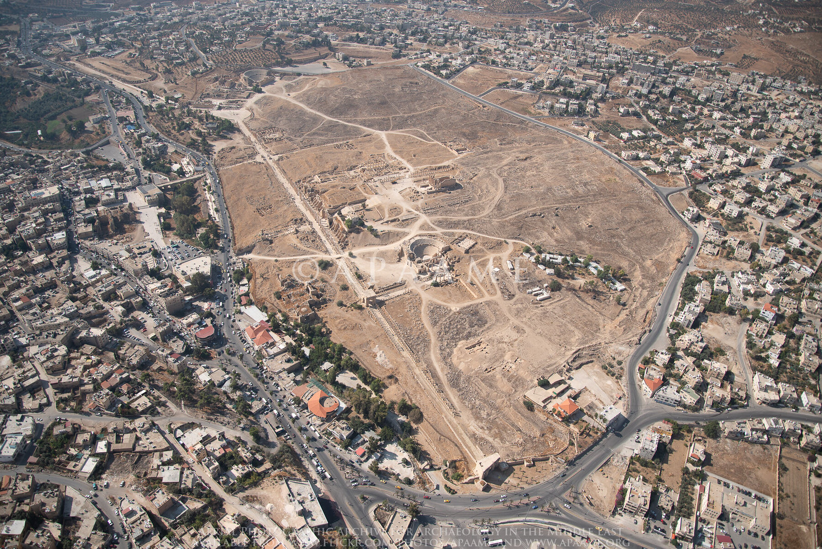
- Reference: APAAME_20191030_PF-0241
- Photographer: Pascal Flohr
- Credit: Aerial Photographic Archive for Archaeology in the Middle East
- Copyright: Creative Commons Attribution-Noncommercial-No Derivative Works
| Transliterated Name | Language | Name |
|---|---|---|
| Jerash | English | |
| Ǧaraš | Arabic | جرش |
| Gérasa | Greek | Γέρασα |
| Antioch on the Chrysorroas | | |
| Garshu | Semitic/Nabatean |
- Jerash Archaeological Park in Google Earth
 Jerash Archaeological Park
click on image to explore this site on a new tab in Google Earth
- Site Plan of Jerash
from Wikipedia
- Fig. 4 - Urbanization of
Jerash from Hellenistic to Late Roman times - from Kehrberg-Ostrasz (2011)
 Figure 4
Schematic overview of Gerasa’s urbanisation from Hellenistic to Late Roman
Kehrberg-Ostrasz (2011) - Fig. 2 - Plan of Umayyad Jerash
from Walmsley and Daamgaard (2005)

Figure 2
Plan summarising the principal urban features of Umayyad Jarash.
- Umayyad mosque
- possible Islamic administrative centre
- market (suq)
- South Tetrakonia piazza (built over)
- Macellum, with Umayyad–Abbasid rebuilding, and south cardo, encroached by structures;
- Oval piazza domestic quarter with fountain;
- Zeus temple forecourt (kiln, monastery?)
- hippodrome and Bishop Marianos church, eighth century use
- church of SS Peter and Paul and Mortuary Church (Umayyad construction date?)
- churches of SS Cosmas and Damianus, St George and St John theBaptist, with Umayyad–Abbasid occupation and iconoclastic-effected mosaics (later eighth century)
- Christian complex of two churches (Cathedral to the east with stairs from the street, St Theodore’s to the west), mid-5th to late 6th century Bath of Placcus (north of St Theodore’s) and houses west of St Theodore’s with extensive Umayyad occupation including a kiln and oil press
- Artemis compound used for ceramic manufacture
- Synagogue church with iconoclastic-effected mosaics
- North Theatre, also industrialised with kilns
- the 1981 ‘mosque’
- central Cardo with blacksmith’s shop and offices
Map modfied from R.E. Pillen in Zayadine (1986).
Walmsley and Daamgaard (2005) - Fig. 1 - Plan of Jerash
showing location of the town's bathhouses from Blanke et al. (2024b)
 Fig. 1
Jerash archaeological site, showing location of the town's bathhouses
(Modified from map by Thomas Lepaon.)
Blanke et al. (2024b)
- Site Plan of Jerash
from Wikipedia
- Fig. 4 - Urbanization of
Jerash from Hellenistic to Late Roman times - from Kehrberg-Ostrasz (2011)
Figure 4
Schematic overview of Gerasa’s urbanisation from Hellenistic to Late Roman
Kehrberg-Ostrasz (2011) - Fig. 2 - Plan of Umayyad Jerash
from Walmsley and Daamgaard (2005)
Figure 2
Plan summarising the principal urban features of Umayyad Jarash.
- Umayyad mosque
- possible Islamic administrative centre
- market (suq)
- South Tetrakonia piazza (built over)
- Macellum, with Umayyad–Abbasid rebuilding, and south cardo, encroached by structures;
- Oval piazza domestic quarter with fountain;
- Zeus temple forecourt (kiln, monastery?)
- hippodrome and Bishop Marianos church, eighth century use
- church of SS Peter and Paul and Mortuary Church (Umayyad construction date?)
- churches of SS Cosmas and Damianus, St George and St John theBaptist, with Umayyad–Abbasid occupation and iconoclastic-effected mosaics (later eighth century)
- Christian complex of two churches (Cathedral to the east with stairs from the street, St Theodore’s to the west), mid-5th to late 6th century Bath of Placcus (north of St Theodore’s) and houses west of St Theodore’s with extensive Umayyad occupation including a kiln and oil press
- Artemis compound used for ceramic manufacture
- Synagogue church with iconoclastic-effected mosaics
- North Theatre, also industrialised with kilns
- the 1981 ‘mosque’
- central Cardo with blacksmith’s shop and offices
Map modfied from R.E. Pillen in Zayadine (1986).
Walmsley and Daamgaard (2005) - Fig. 1 - Plan of Jerash
showing location of the town's bathhouses from Blanke et al. (2024b)
Fig. 1
Jerash archaeological site, showing location of the town's bathhouses
(Modified from map by Thomas Lepaon.)
Blanke et al. (2024b)
- Fig. 2 - Plan of the
Central Bathhouses from Blanke et al. (2024b)
 Fig. 2
Plan of the Central Bathhouses highlighting location of latrine and bathhouse sewers
(Plan by Louise Blanke)
Blanke et al. (2024b) - Fig. 3 - Aerial View
of latrine in Central Bathhouse from Blanke et al. (2024b)
 Fig. 3
Overview of latrine in Central Bathhouse looking west.
(© Islamic Jarash Project.)
Blanke et al. (2024b)
- Fig. 2 - Plan of the
Central Bathhouses from Blanke et al. (2024b)
Fig. 2
Plan of the Central Bathhouses highlighting location of latrine and bathhouse sewers
(Plan by Louise Blanke)
Blanke et al. (2024b) - Fig. 3 - Aerial View
of latrine in Central Bathhouse from Blanke et al. (2024b)
Fig. 3
Overview of latrine in Central Bathhouse looking west.
(© Islamic Jarash Project.)
Blanke et al. (2024b)
- Fig. 5.10 Plan of the
Synagogue Church from Lichtenberger and Raja (2025)
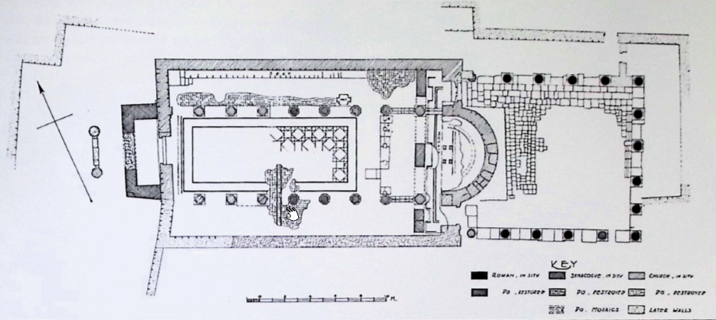 Figure 5.10
Plan of the Synagogue Church
(Kraeling, 1938)
Click on image to open in a new tab
Lichtenberger and Raja (2025) - Fig. 5.11 Plan of the
Synagogue Church and the Mosaic Hall north of it from Lichtenberger and Raja (2025)
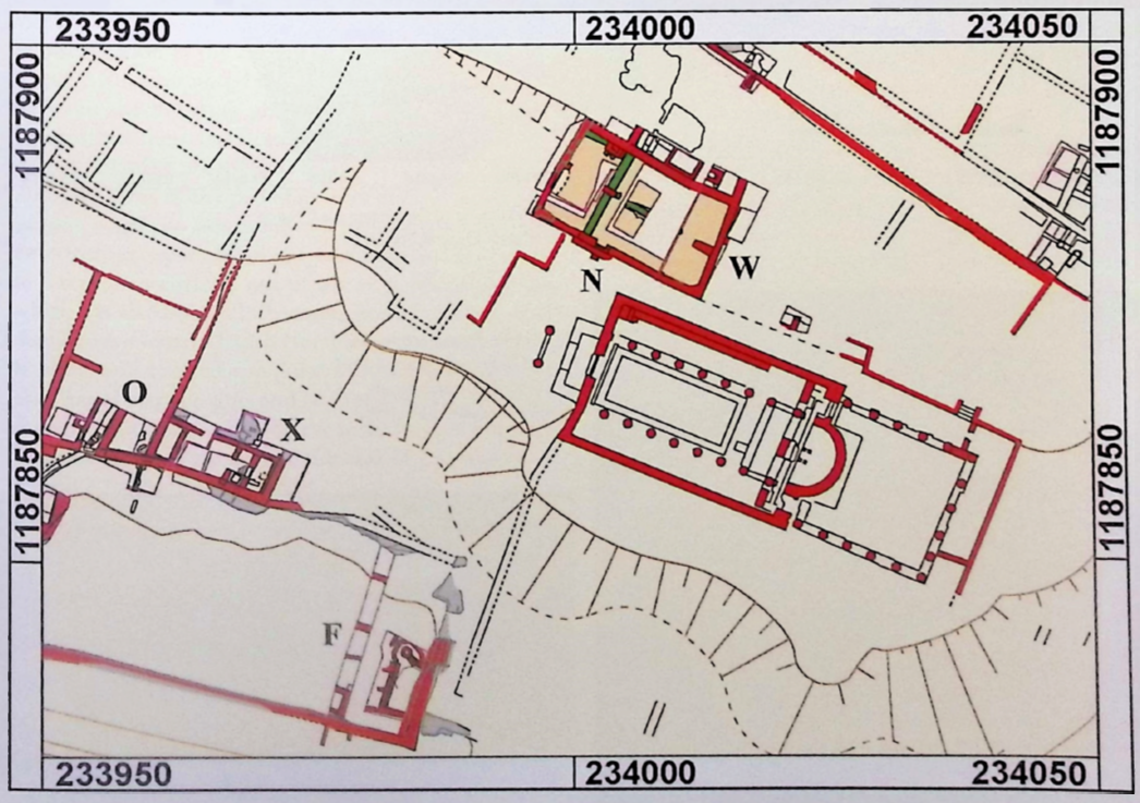 Figure 5.11
State Plan of the Synagogue Church and the Mosaic Hall north of it
(the Danish-German Jerash Northwest Quarter Project)
Click on image to open in a new tab
Lichtenberger and Raja (2025)
- Fig. 5.10 Plan of the
Synagogue Church from Lichtenberger and Raja (2025)
Figure 5.10
Plan of the Synagogue Church
(Kraeling, 1938)
Click on image to open in a new tab
Lichtenberger and Raja (2025) - Fig. 5.11 Plan of the
Synagogue Church and the Mosaic Hall north of it from Lichtenberger and Raja (2025)
Figure 5.11
State Plan of the Synagogue Church and the Mosaic Hall north of it
(the Danish-German Jerash Northwest Quarter Project)
Click on image to open in a new tab
Lichtenberger and Raja (2025)

Map of potential archaeological features derived from airborne lidar and archival photography. A large number of previously recorded and new features were recorded in the better-preserved part of the city to the west of the wadi
Legend
- Extramural arch (‘Hadrian’s Arch’)
- Church of Bishop Marianos
- Hippodrome
- Sanctuary of Zeus Olympios
- South Gate
- Water Gate
- City walls
- Shops and structures along the South Gate street
- South Theatre
- South-East Gate (blocked)
- Procopius Church
- ‘Oval Piazza’
- Roman house or church (after Schumacher 1902)
- ‘Camp Hill’ (location of modern museum)
- Byzantine villa (after Seigne & Zubi 1997)
- Agora (‘Macellum’)
- Area of the House of the Blues
- South Bridge
- Possible South-West Aqueduct
- East Baths
- Mortuary Church
- Late Antique and Early Islamic structures
- South Tetrapylon
- Church of Sts Peter and Paul
- Side street (‘South Decumanus’)
- Mosque
- Main Street (‘cardo’)
- Early Islamic domestic quarter
- Cathedral complex
- ‘Temple C’ (after Fisher 1938: pl. I
- Church of St Theodore and Fountain Court
- Nymphaion
- Buildings west of the Wadi
- Small Eastern Baths
- Chapel of Elia, Mary and Soreg
- South-West Gate
- Churches of Sts George, John, Cosmas and Damian
- Approximate location of ‘House of the Poets and Muses’
- Ecclesiastic complexes and Baths of Placcus
- Propylaea Church
- Church of Bishop Genesius
- Ottoman House
- West Baths
- Large rock-cut cistern
- Sanctuary of Artemis
- North Theatre
- Spring (Ain Karawan)
- Synagogue/Church of the Electi Iustiniani
- Church of Bishop Isaiah
- Side street (‘North Decumanus’)
- North Tetrapylon
- Hall of the Electi Iustiniani
- Umayyad houses
- Middle Islamic hamlet (and large courtyard)55 Church of the Prophets, Apostles and Martyrs56 Large open area (‘forum’) and basilica
- Roman edifice and cistern
- Middle Islamic structures
- Circassian house
- North-West Aqueduct
- Early modern water channel
- North Gate
- Chrysorrhoas/Wadi Jerash
Lichtenberger et. al. (2019)
 Figure 2
Synthesis of remotely sensed features and existing mapping from previous studies. Hypothetical building elements (after Lepaon Reference Lepaon, 2011; Lichtenberger & Raja, 2017) are highlighted in pink. Most of the buildings on the eastern side of the valley are no longer extant
map © Danish-German Jerash Northwest Quarter
Lichtenberger et. al. (2019)
Figure 3As Figure 2, with points of interest highlighted (see Table 1)
Legend
- Extramural arch (‘Hadrian’s Arch’)
- Church of Bishop Marianos
- Hippodrome
- Sanctuary of Zeus Olympios
- South Gate
- Water Gate
- City walls
- Shops and structures along the South Gate street
- South Theatre
- South-East Gate (blocked)
- Procopius Church
- ‘Oval Piazza’
- Roman house or church (after Schumacher 1902)
- ‘Camp Hill’ (location of modern museum)
- Byzantine villa (after Seigne & Zubi 1997)
- Agora (‘Macellum’)
- Area of the House of the Blues
- South Bridge
- Possible South-West Aqueduct
- East Baths
- Mortuary Church
- Late Antique and Early Islamic structures
- South Tetrapylon
- Church of Sts Peter and Paul
- Side street (‘South Decumanus’)
- Mosque
- Main Street (‘cardo’)
- Early Islamic domestic quarter
- Cathedral complex
- ‘Temple C’ (after Fisher 1938: pl. I
- Church of St Theodore and Fountain Court
- Nymphaion
- Buildings west of the Wadi
- Small Eastern Baths
- Chapel of Elia, Mary and Soreg
- South-West Gate
- Churches of Sts George, John, Cosmas and Damian
- Approximate location of ‘House of the Poets and Muses’
- Ecclesiastic complexes and Baths of Placcus
- Propylaea Church
- Church of Bishop Genesius
- Ottoman House
- West Baths
- Large rock-cut cistern
- Sanctuary of Artemis
- North Theatre
- Spring (Ain Karawan)
- Synagogue/Church of the Electi Iustiniani
- Church of Bishop Isaiah
- Side street (‘North Decumanus’)
- North Tetrapylon
- Hall of the Electi Iustiniani
- Umayyad houses
- Middle Islamic hamlet (and large courtyard)55 Church of the Prophets, Apostles and Martyrs56 Large open area (‘forum’) and basilica
- Roman edifice and cistern
- Middle Islamic structures
- Circassian house
- North-West Aqueduct
- Early modern water channel
- North Gate
- Chrysorrhoas/Wadi Jerash
Lichtenberger et. al. (2019)
- from Stott, Raja, and Lichtenberger (2019)
- from Jerash Aerial Photos at figshare
- Magnifiable image is downsampled - for full resolution image go to download links
 2015 Orthophoto of Jerash City
Click on Image for high resolution magnifiable image
Dataset on figshare authored by David Stott, Rubina Raja, and Achim Lichtenberger in 2019
- from Stott, Raja, and Lichtenberger (2019)
- from Jerash Aerial Photos at figshare
- Magnifiable image is not downsampled
 1953 Orthophoto of Wadi Jerash
Click on Image for high resolution magnifiable image
Dataset on figshare authored by David Stott, Rubina Raja, and Achim Lichtenberger in 2019
- Panorama of West Baths
West Baths - photo by JW
 Stitched Panorama of West Baths at Jerash
Click on image to open a high resolution magnifiable image in a new tab
Note: Some distortion is inevitable in a stitched panorama
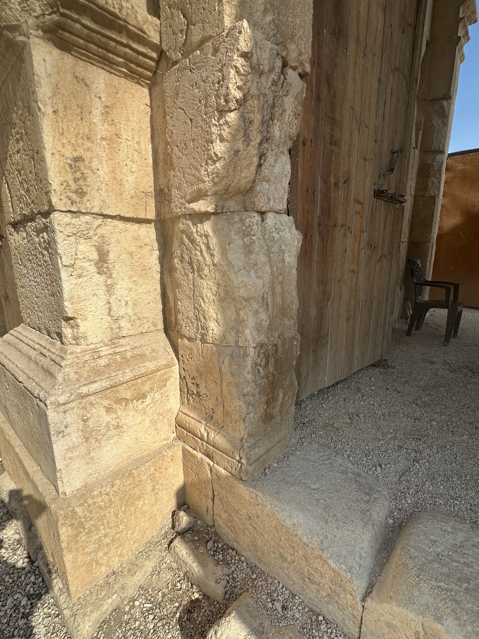
Photos by Jefferson Williams - 23 June 2025 - Dropped Archstones
and Spalled corner in West Baths - photo by JW
 Dropped Archstones and Spalled corner in West Baths at Jerash
Click on image to open a high resolution magnifiable image in a new tab
Photo by Jefferson Williams - 23 June 2025 - Dropped Keystones
- photo by JW
 Dropped Keystones in West Baths at Jerash
Click on image to open a high resolution magnifiable image in a new tab
Photo by Jefferson Williams - 23 June 2025 - Dropped Keystones Closeup
- photo by JW
 Dropped Keystones Closeup in West Baths at Jerash
Click on image to open a high resolution magnifiable image in a new tab
Photo by Jefferson Williams - 23 June 2025 - Shifted Blocks - photo by JW
 Shifted Blocks in West Baths at Jerash
Click on image to open a high resolution magnifiable image in a new tab
Photo by Jefferson Williams - 23 June 2025 - Shifted Blocks - photo by JW
 Shifted Blocks in West Baths at Jerash
Click on image to open a high resolution magnifiable image in a new tab
Photo by Jefferson Williams - 23 June 2025 - Shifted Blocks - photo by JW
 Shifted Blocks in West Baths at Jerash
Click on image to open a high resolution magnifiable image in a new tab
Photo by Jefferson Williams - 23 June 2025 - Shifted Blocks and
Dropped Keystones - photo by JW
 Shifted Blocks and Dropped Keystones in West Baths at Jerash
Click on image to open a high resolution magnifiable image in a new tab
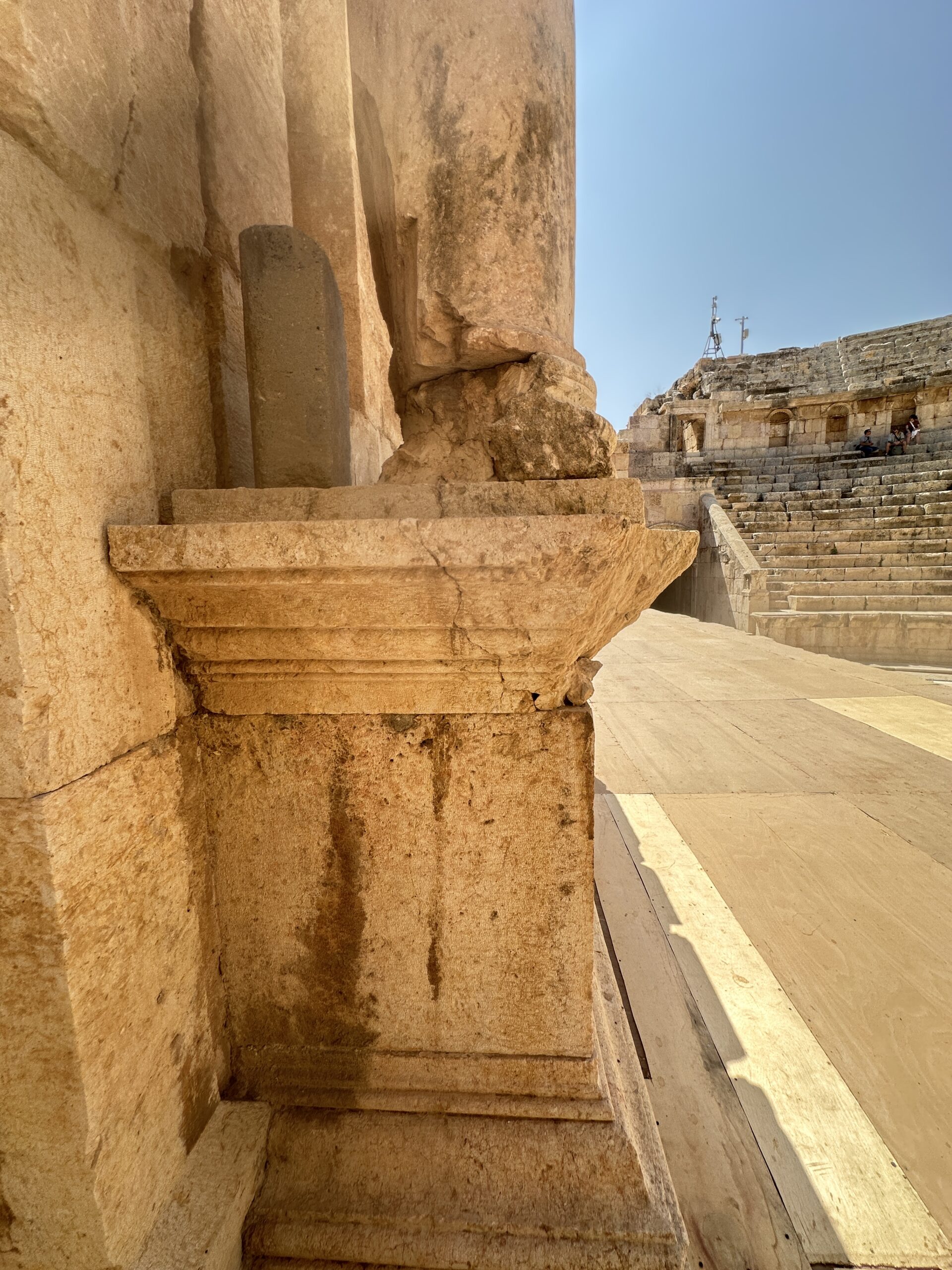
Photo by Jefferson Williams - 23 June 2025 - Shifted Column Segments
Shifted Column Segments - photo by JW
 Shifted Column Segments in West Baths at Jerash
Click on image to open a high resolution magnifiable image in a new tab
Photo by Jefferson Williams - 23 June 2025 - Shifted Keystones and
Spalled Corners - photo by JW
 Shifted Keystones and Spalled Corners in West Baths at Jerash
Click on image to open a high resolution magnifiable image in a new tab
Photo by Jefferson Williams - 23 June 2025

- Panorama of West Baths
West Baths - photo by JW
Stitched Panorama of West Baths at Jerash
Click on image to open a high resolution magnifiable image in a new tab
Note: Some distortion is inevitable in a stitched panorama
Photos by Jefferson Williams - 23 June 2025 - Dropped Archstones
and Spalled corner in West Baths - photo by JW
Dropped Archstones and Spalled corner in West Baths at Jerash
Click on image to open a high resolution magnifiable image in a new tab
Photo by Jefferson Williams - 23 June 2025 - Dropped Keystones
- photo by JW
Dropped Keystones in West Baths at Jerash
Click on image to open a high resolution magnifiable image in a new tab
Photo by Jefferson Williams - 23 June 2025 - Dropped Keystones Closeup
- photo by JW
Dropped Keystones Closeup in West Baths at Jerash
Click on image to open a high resolution magnifiable image in a new tab
Photo by Jefferson Williams - 23 June 2025 - Shifted Blocks - photo by JW
Shifted Blocks in West Baths at Jerash
Click on image to open a high resolution magnifiable image in a new tab
Photo by Jefferson Williams - 23 June 2025 - Shifted Blocks - photo by JW
Shifted Blocks in West Baths at Jerash
Click on image to open a high resolution magnifiable image in a new tab
Photo by Jefferson Williams - 23 June 2025 - Shifted Blocks - photo by JW
Shifted Blocks in West Baths at Jerash
Click on image to open a high resolution magnifiable image in a new tab
Photo by Jefferson Williams - 23 June 2025 - Shifted Blocks and
Dropped Keystones - photo by JW
Shifted Blocks and Dropped Keystones in West Baths at Jerash
Click on image to open a high resolution magnifiable image in a new tab
Photo by Jefferson Williams - 23 June 2025 - Shifted Column Segments
Shifted Column Segments - photo by JW
Shifted Column Segments in West Baths at Jerash
Click on image to open a high resolution magnifiable image in a new tab
Photo by Jefferson Williams - 23 June 2025 - Shifted Keystones and
Spalled Corners - photo by JW
Shifted Keystones and Spalled Corners in West Baths at Jerash
Click on image to open a high resolution magnifiable image in a new tab
Photo by Jefferson Williams - 23 June 2025
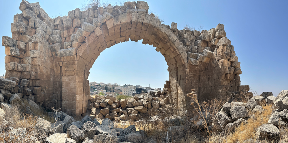
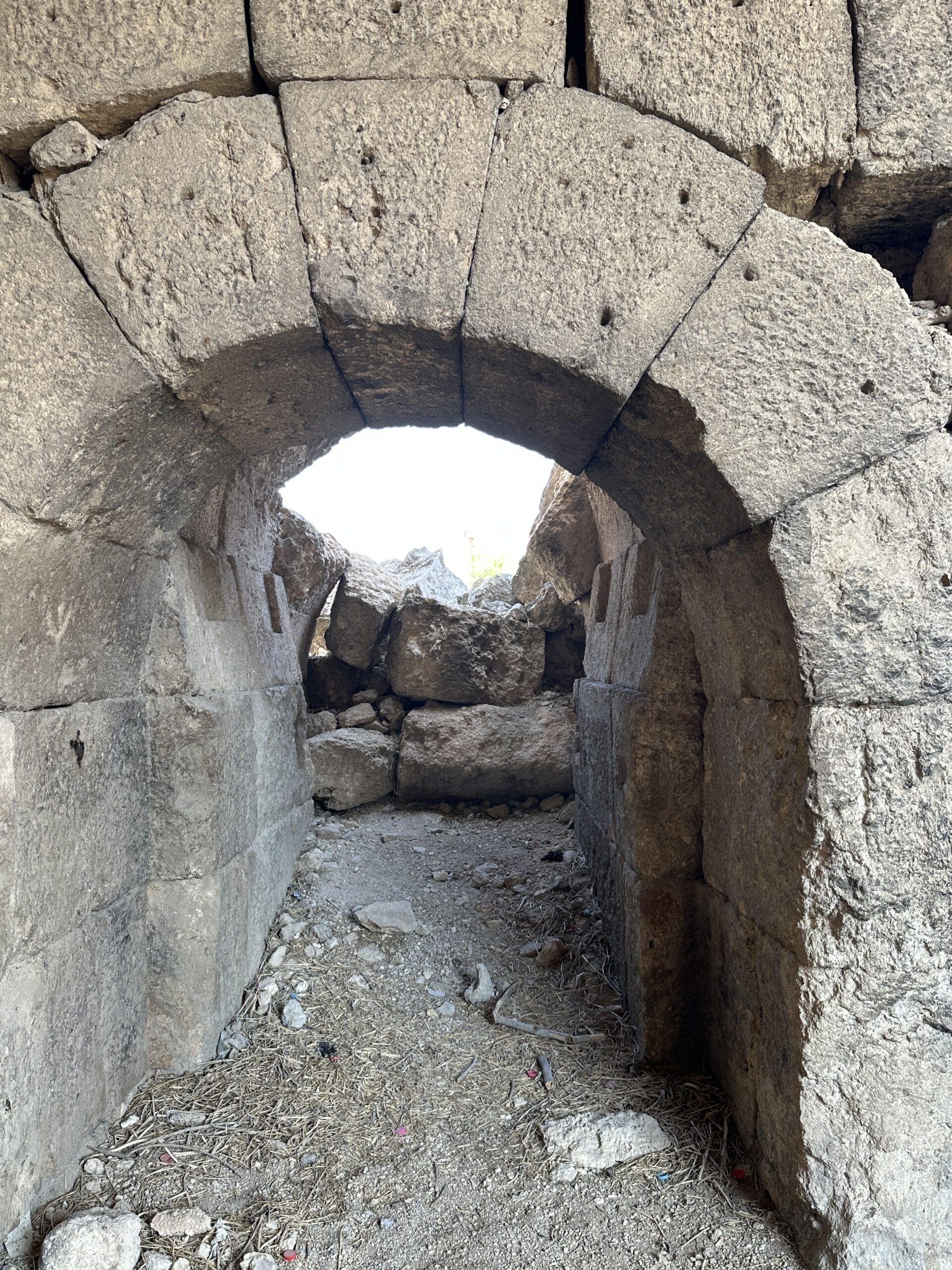
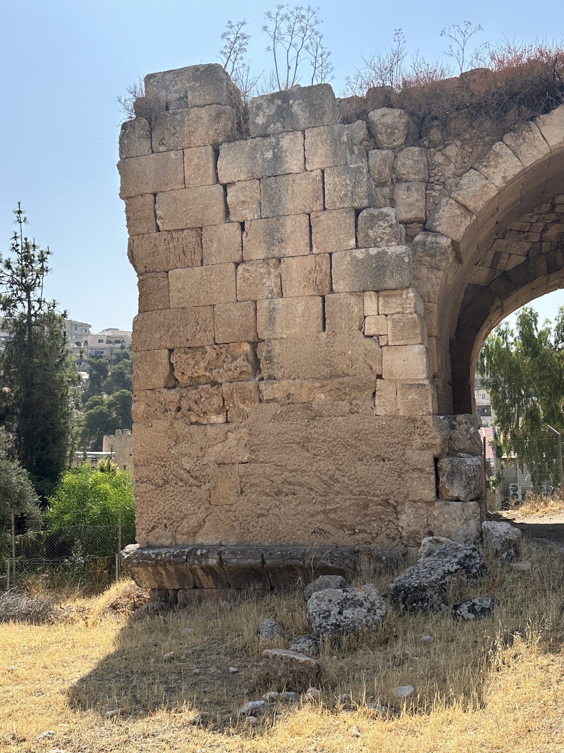
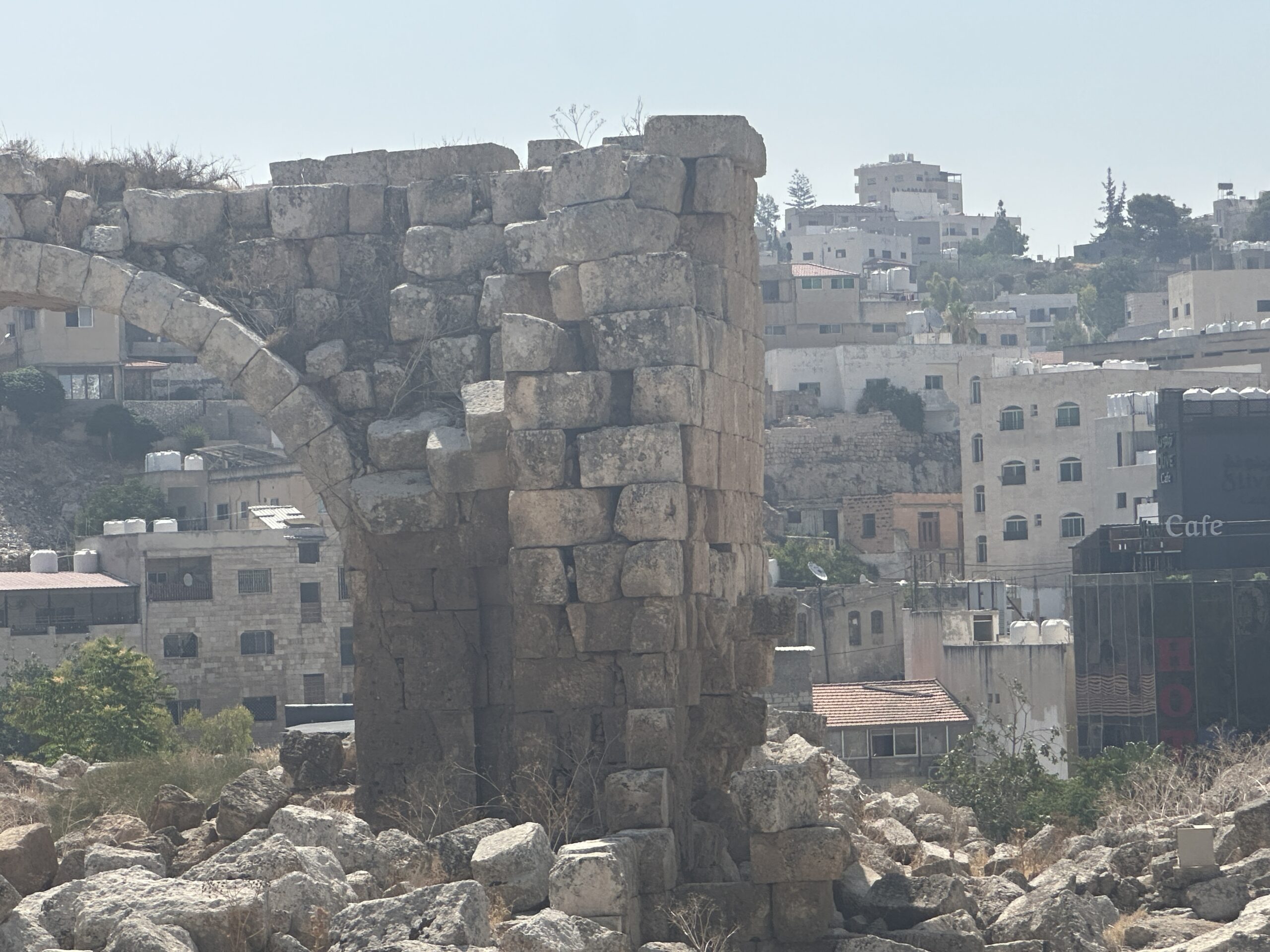
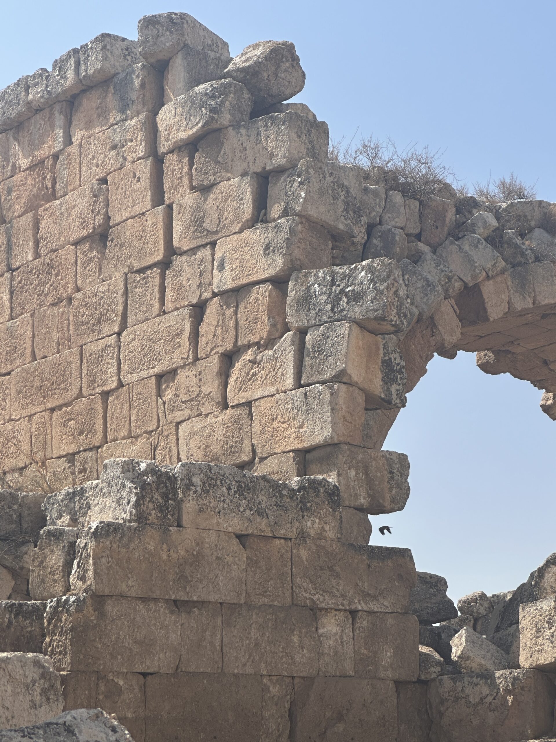
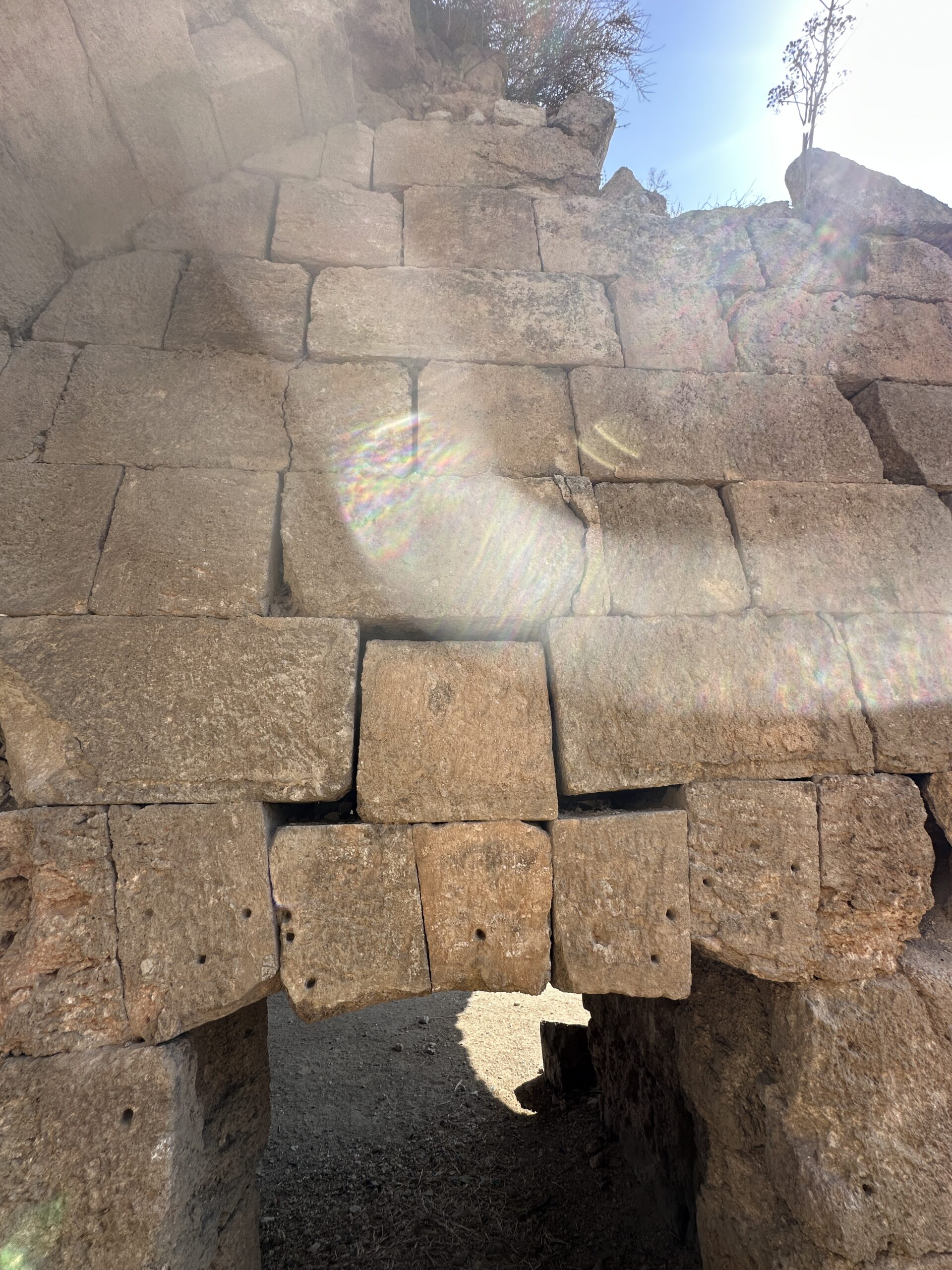
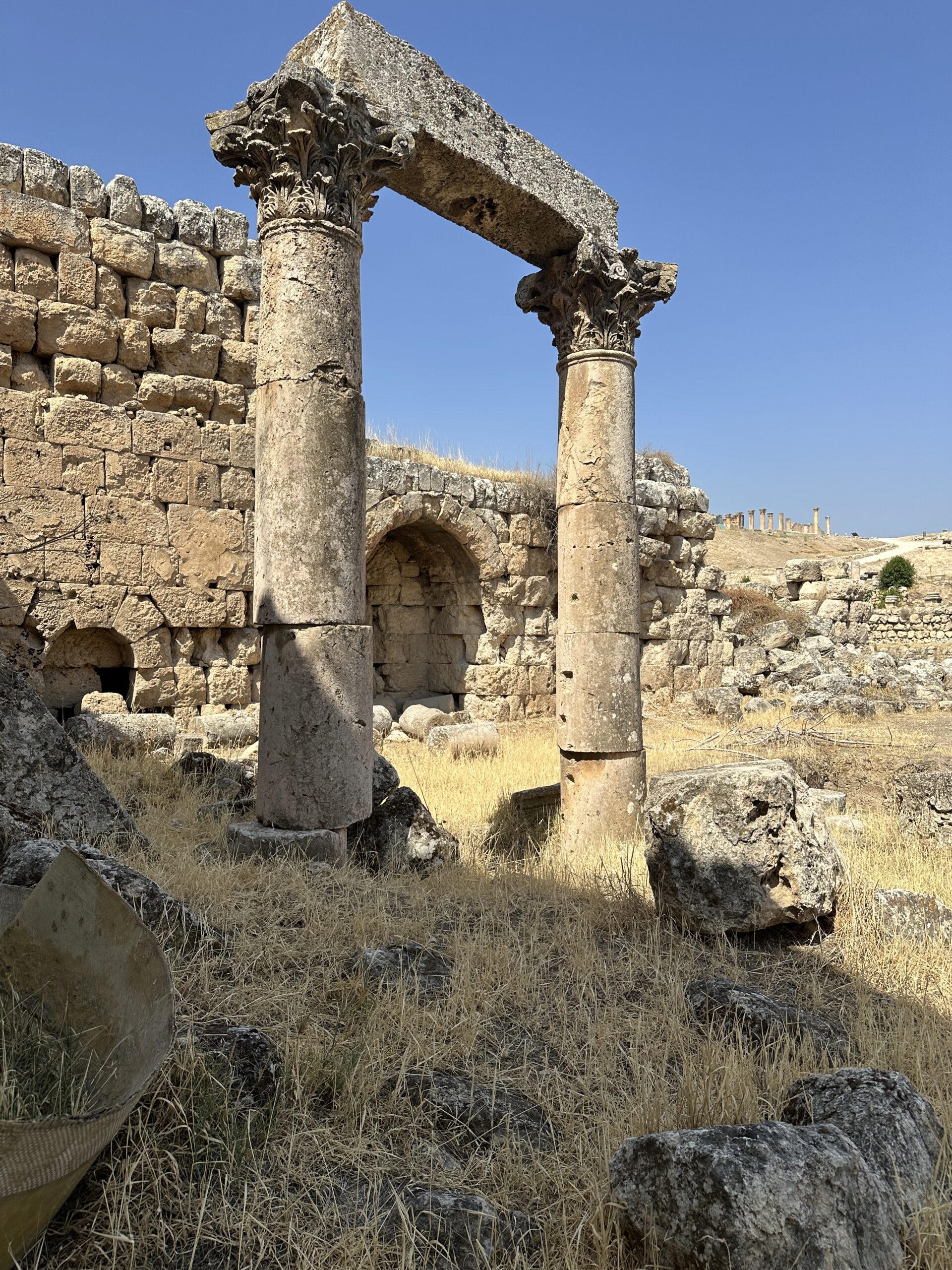
- Shifted Stones, Spalled
Corners, Fractures, and Displaced Archstones at Hadrian's Arch - photo by JW
 Shifted Stones, Spalled Corners, Fractures, and Displaced Archstones at Hadrian's Arch in Jerash
Click on image to open a high resolution magnifiable image in a new tab
Photo by Jefferson Williams - 23 June 2025
- Shifted Stones, Spalled
Corners, Fractures, and Displaced Archstones at Hadrian's Arch - photo by JW
Shifted Stones, Spalled Corners, Fractures, and Displaced Archstones at Hadrian's Arch in Jerash
Click on image to open a high resolution magnifiable image in a new tab
Photo by Jefferson Williams - 23 June 2025
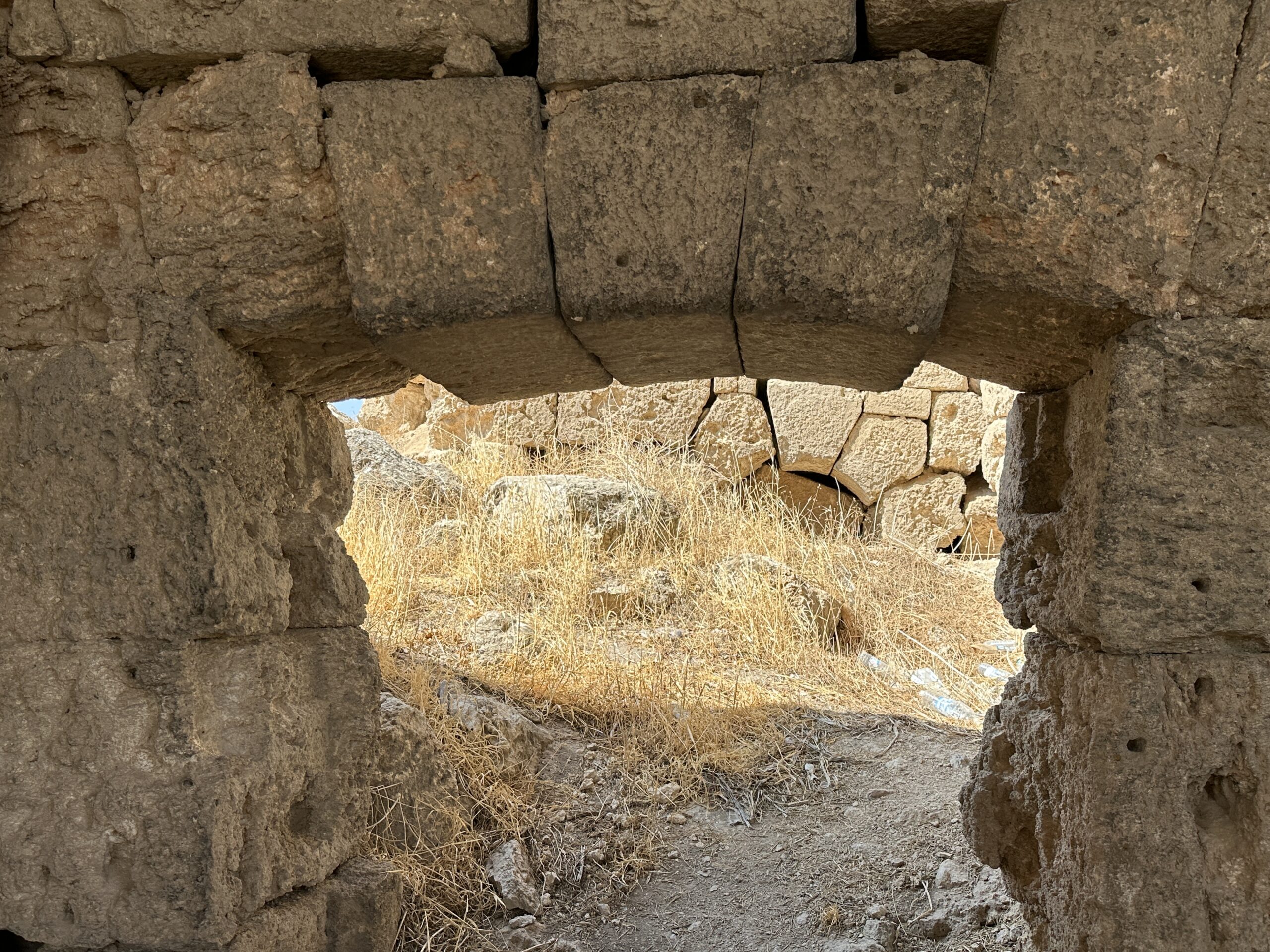
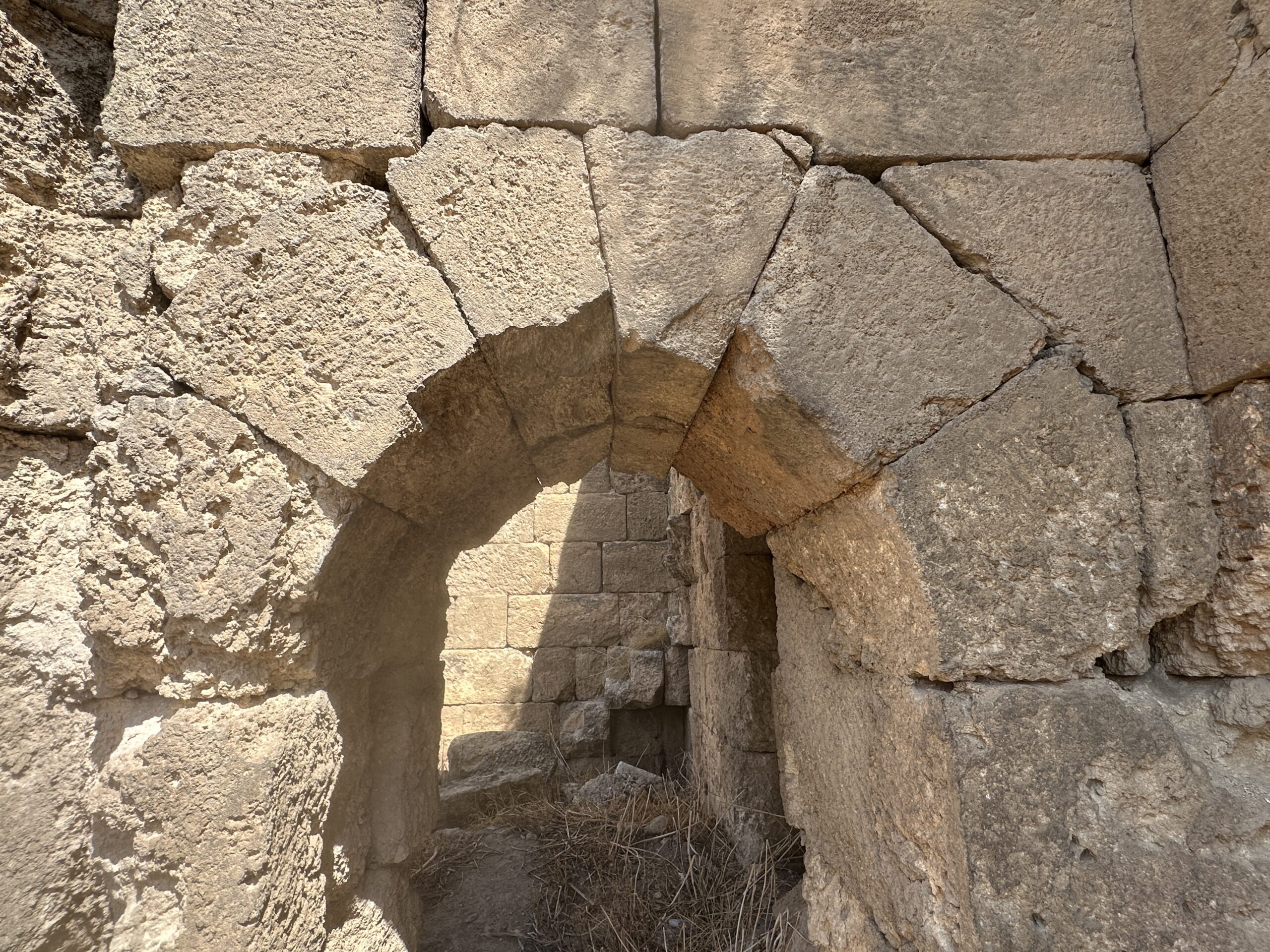
- Through-going Fractures
at South Gate - photo by JW
 Fractures at South Gate in Jerash
Click on image to open a high resolution magnifiable image in a new tab
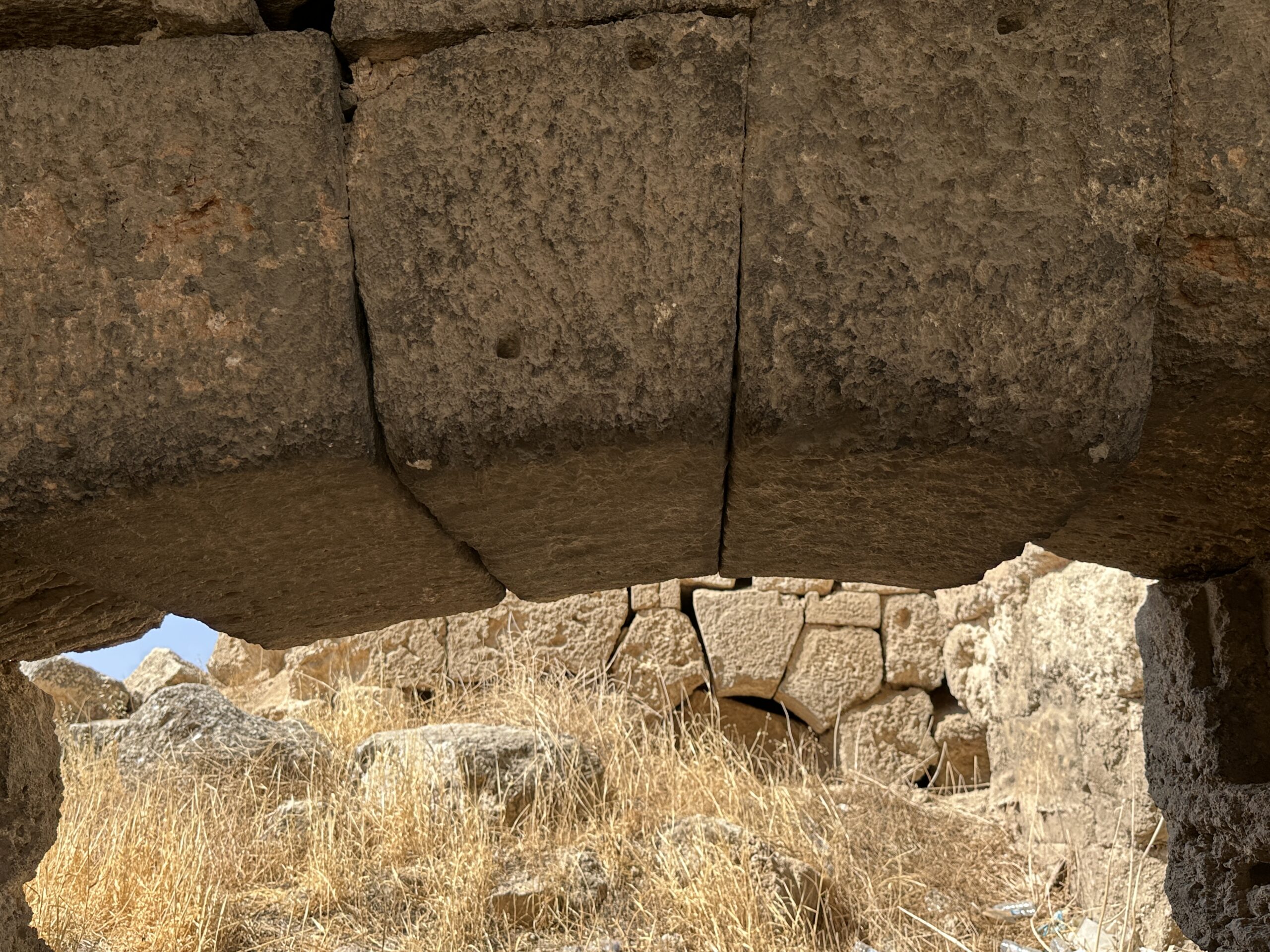
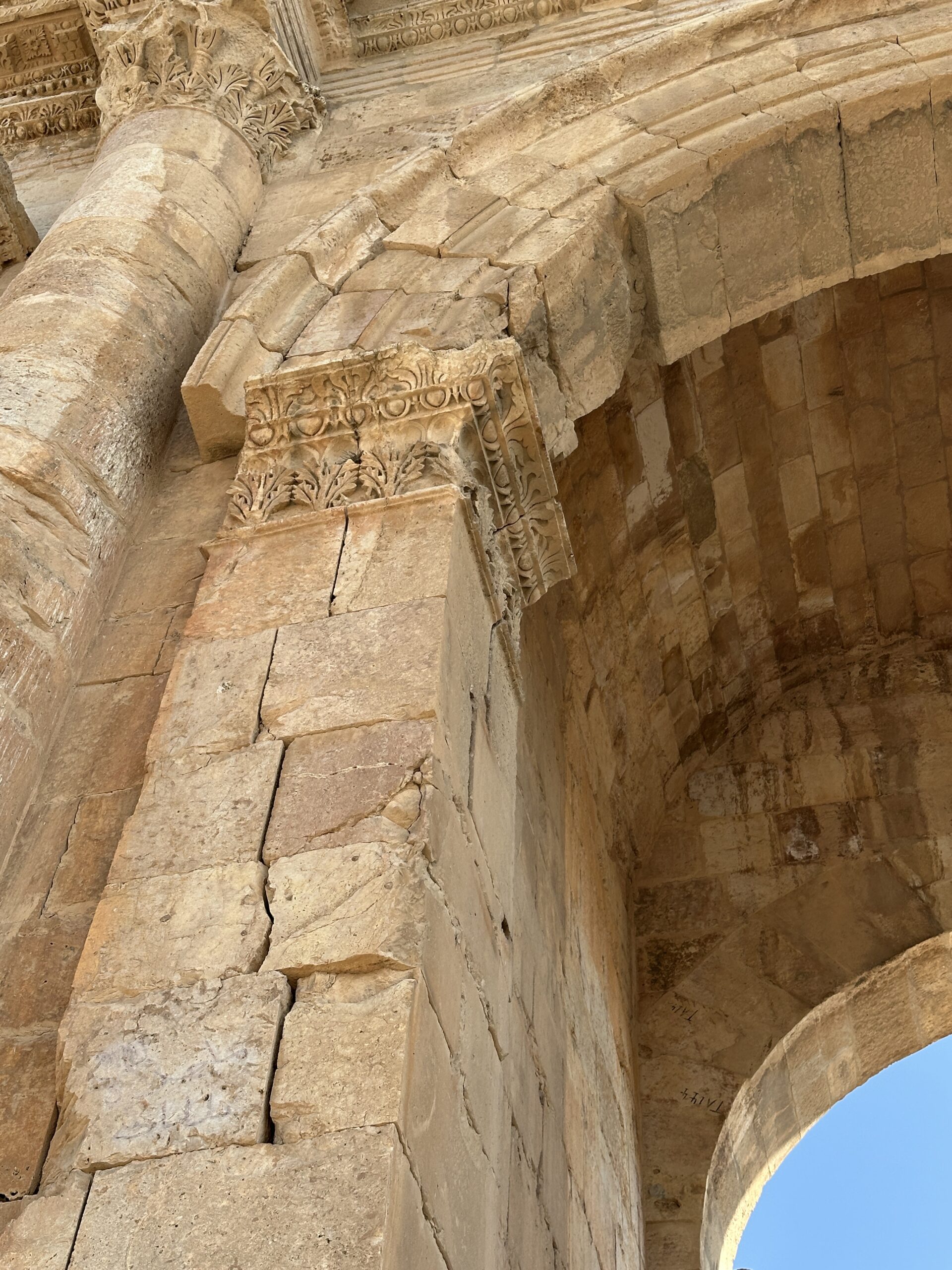
Photo by Jefferson Williams - 23 June 2025 - Spalled Corners and
through-going fractures at South Gate - photo by JW
 Spalled Corners at South Gate in Jerash
Click on image to open a high resolution magnifiable image in a new tab
Photo by Jefferson Williams - 23 June 2025
- Through-going Fractures
at South Gate - photo by JW
Fractures at South Gate in Jerash
Click on image to open a high resolution magnifiable image in a new tab
Photo by Jefferson Williams - 23 June 2025 - Spalled Corners and
through-going fractures at South Gate - photo by JW
Spalled Corners at South Gate in Jerash
Click on image to open a high resolution magnifiable image in a new tab
Photo by Jefferson Williams - 23 June 2025
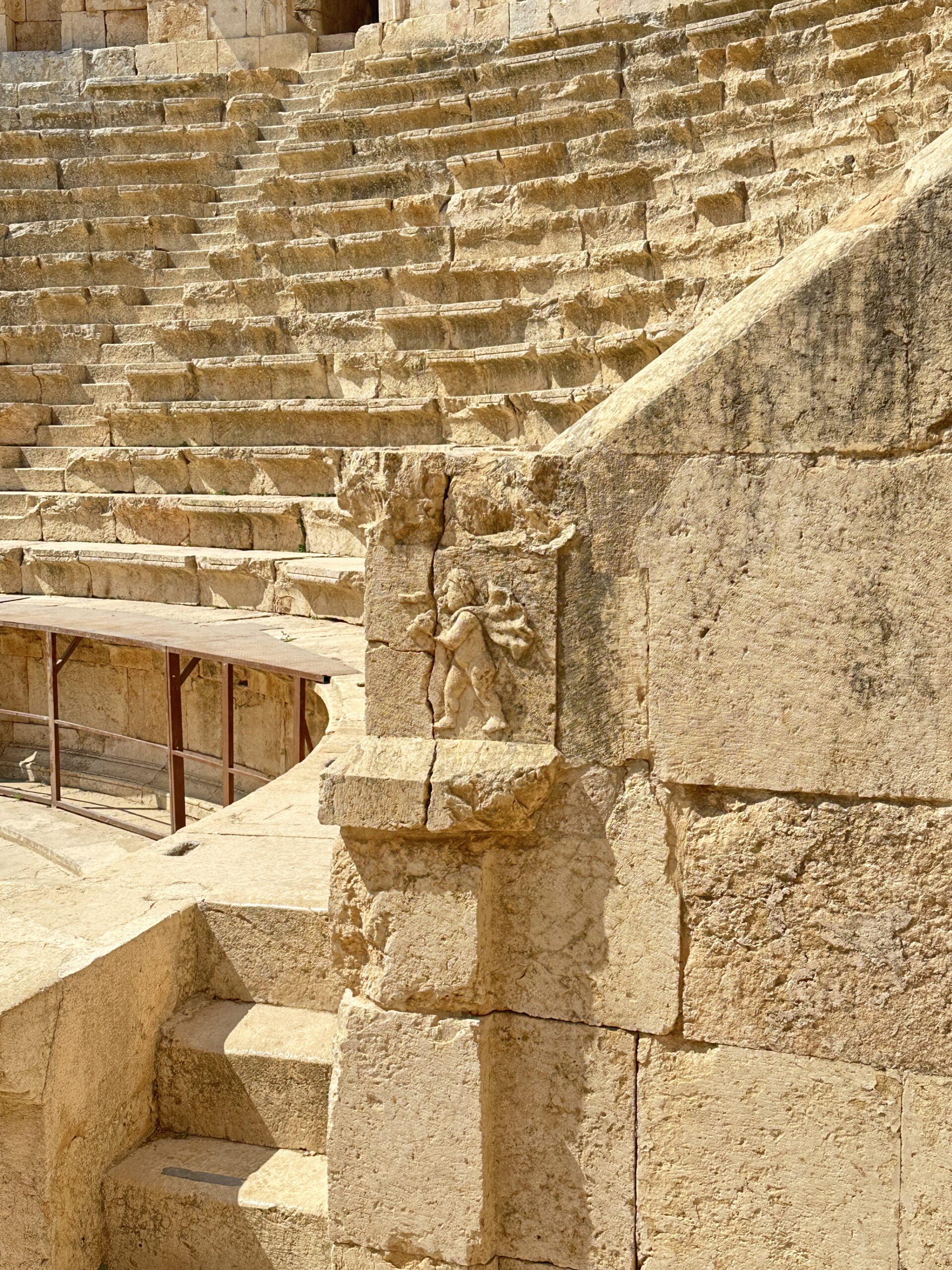
- Fractures at South
Theater - photo by JW
 Fractures at South Theater in Jerash
Click on image to open a high resolution magnifiable image in a new tab
Photo by Jefferson Williams - 23 June 2025 - Fractures at South
Theater - photo by JW
 Fractures at South Theater in Jerash
Click on image to open a high resolution magnifiable image in a new tab
Photo by Jefferson Williams - 23 June 2025
- Fractures at South
Theater - photo by JW
Fractures at South Theater in Jerash
Click on image to open a high resolution magnifiable image in a new tab
Photo by Jefferson Williams - 23 June 2025 - Fractures at South
Theater - photo by JW
Fractures at South Theater in Jerash
Click on image to open a high resolution magnifiable image in a new tab
Photo by Jefferson Williams - 23 June 2025
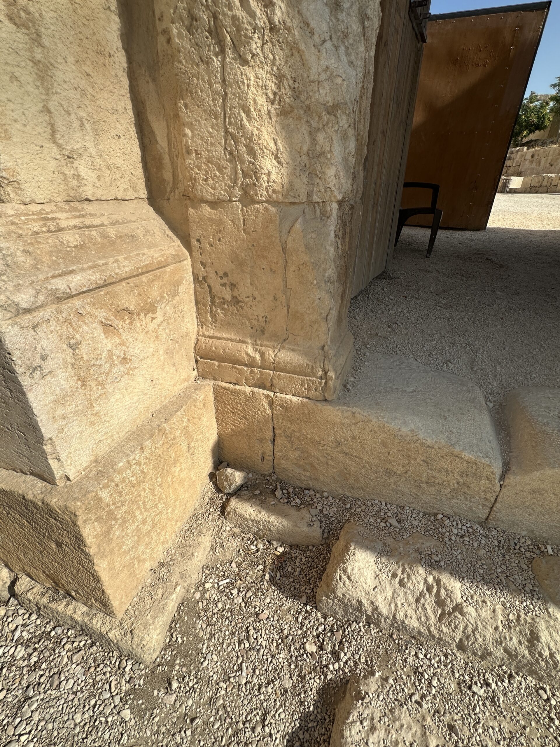
- Shifted Columns at
Temple of Artemis - photo by JW
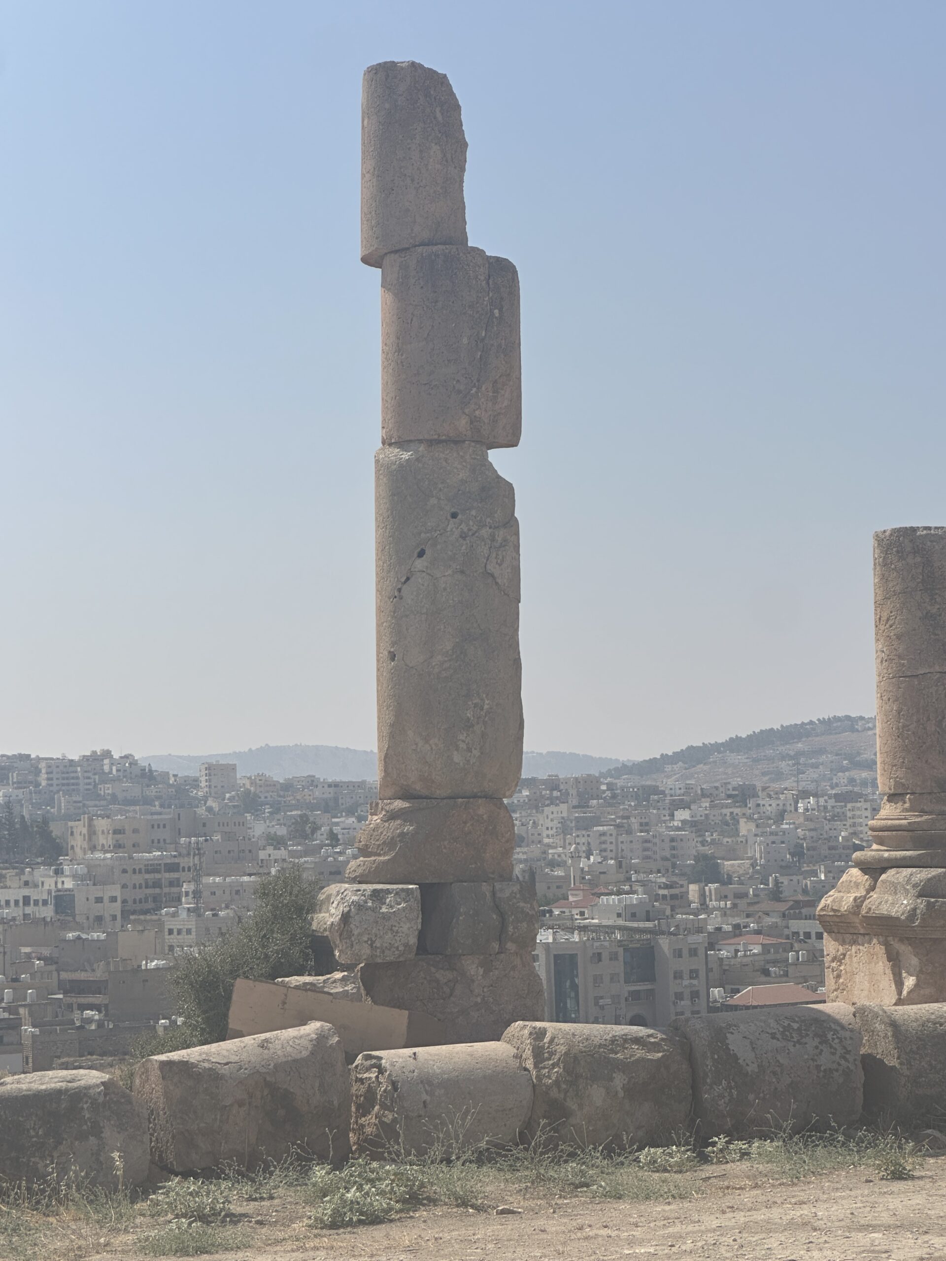 Shifted Column Segments at Temple of Artemis in Jerash
Click on image to open a high resolution magnifiable image in a new tab
Photo by Jefferson Williams - 23 June 2025
- Shifted Columns at
Temple of Artemis - photo by JW
Shifted Column Segments at Temple of Artemis in Jerash
Click on image to open a high resolution magnifiable image in a new tab
Photo by Jefferson Williams - 23 June 2025
- Fig. 5.9 The excavated
Synagogue Church from Lichtenberger and Raja (2025)
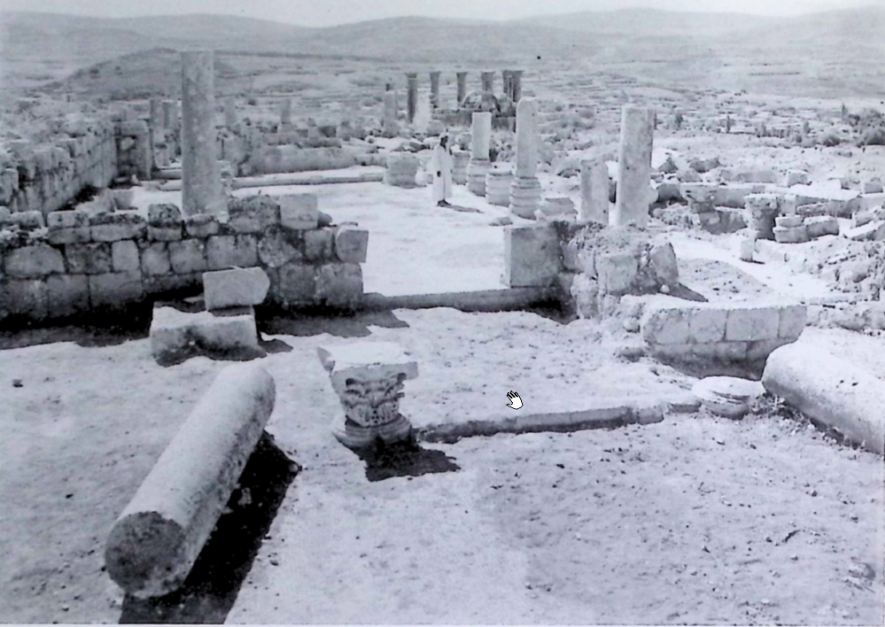 Figure 5.9
Photograph of the excavated Synagogue Church
(courtesy of Yale University Art Gallery (YUAG))
Click on image to open in a new tab
Lichtenberger and Raja (2025) - Fig. 3.38b Synagogue Church (?)
during excavation showing the orientation of fallen columns from Boyer (2022)
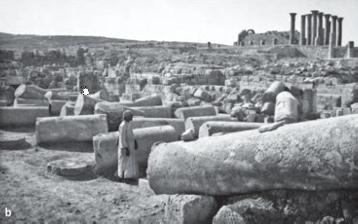 Figure 3.38b
Photographs of the basilica of St Theodore's Church during excavation showing the orientation of fallen columns
JW: This may in fact be from the Synagogue Church as seems to be indicated in the narraive text by Boryer (2022)
London, UCL, StTheodore_23_1441 3273846_98ed97777f o.jpg. UCL, Institute of Archaeology
Click on image to open in a new tab
Boyer (2022)
- Fig. 5.9 The excavated
Synagogue Church from Lichtenberger and Raja (2025)
Figure 5.9
Photograph of the excavated Synagogue Church
(courtesy of Yale University Art Gallery (YUAG))
Click on image to open in a new tab
Lichtenberger and Raja (2025) - Fig. 3.38b Synagogue Church (?)
during excavation showing the orientation of fallen columns from Boyer (2022)
Figure 3.38b
Photographs of the basilica of St Theodore's Church during excavation showing the orientation of fallen columns
JW: This may in fact be from the Synagogue Church as seems to be indicated in the narraive text by Boryer (2022)
London, UCL, StTheodore_23_1441 3273846_98ed97777f o.jpg. UCL, Institute of Archaeology
Click on image to open in a new tab
Boyer (2022)
- Fig. 5.7 Photo of the
western side of Gerasa in 1930 from Lichtenberger and Raja (2025)
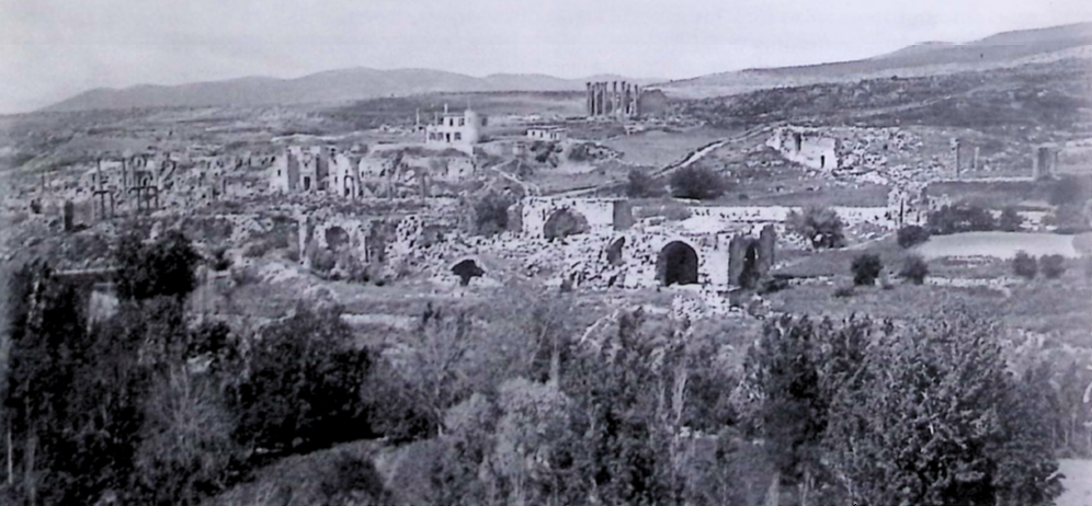 Figure 5.7
View of the western side of Gerasa. According to the notes in the YUAG archive the photo was taken on 14 April 1930 from a hill cast of the police station
(courtesy of Yale University Art Gallery (YUAG))
Click on image to open in a new tab
Lichtenberger and Raja (2025)
- Fig. 5.7 Photo of the
western side of Gerasa in 1930 from Lichtenberger and Raja (2025)
Figure 5.7
View of the western side of Gerasa. According to the notes in the YUAG archive the photo was taken on 14 April 1930 from a hill cast of the police station
(courtesy of Yale University Art Gallery (YUAG))
Click on image to open in a new tab
Lichtenberger and Raja (2025)
| Effect | Location | Image(s) | Description |
|---|---|---|---|
|
Rotunda at Jerash (possibly the North Tetrapylon) Plan of Jerash. North is to the right.
Click on image to open in a new tab Holger Behr - Wikipedia - Public Domain |
|
|
|
Jerash |
|
- Earthquake Archeological Effects
from Rodríguez-Pascua et al (2013: 221-224)
 Earthquake Archeological
Effects Chart
Earthquake Archeological
Effects Chart
Click on image to open in a new tab
Rodríguez-Pascua et al (2013) - Environmental Effects (ESI 2007)
 Graphic Representation of
ESI 2007 Intensity
Graphic Representation of
ESI 2007 Intensity
Click on image to open in a new tab
- Synoptic Table of ESI 2007 Intensity Degrees
from Michetti et al. (2007)
 Synoptic Table of ESI 2007
Intensity Degrees
Synoptic Table of ESI 2007
Intensity Degrees
Accuracy improves in higher degrees, especially VIII–XII.
Click on image to open in a new tab
Michetti et al. (2007) - Environmental Effects vs. Intensity
from Michetti et al. (2007)
 Diagnostic ranges for
environmental effects by intensity
Diagnostic ranges for
environmental effects by intensity
Click on image to open in a new tab
Michetti et al. (2007) - Simple MMI Intensity Scale
 Simple MMI Intensity
Scale
Simple MMI Intensity
Scale
Click on image to open in a new tab

| Effect | Location | Image(s) | Description | Intensity |
|---|---|---|---|---|
|
Rotunda at Jerash (possibly the North Tetrapylon)
Plan of Jerash. North is to the right.
Click on image to open in a new tab Holger Behr - Wikipedia - Public Domain |
|
|
|
|
Jerash |
|
|


- from Lichtenberger and Raja (2025)
- Table 2.2 List of seismic damage
in Jerash between the 1st and 19th centuries CE from Lichtenberger and Raja (2025)
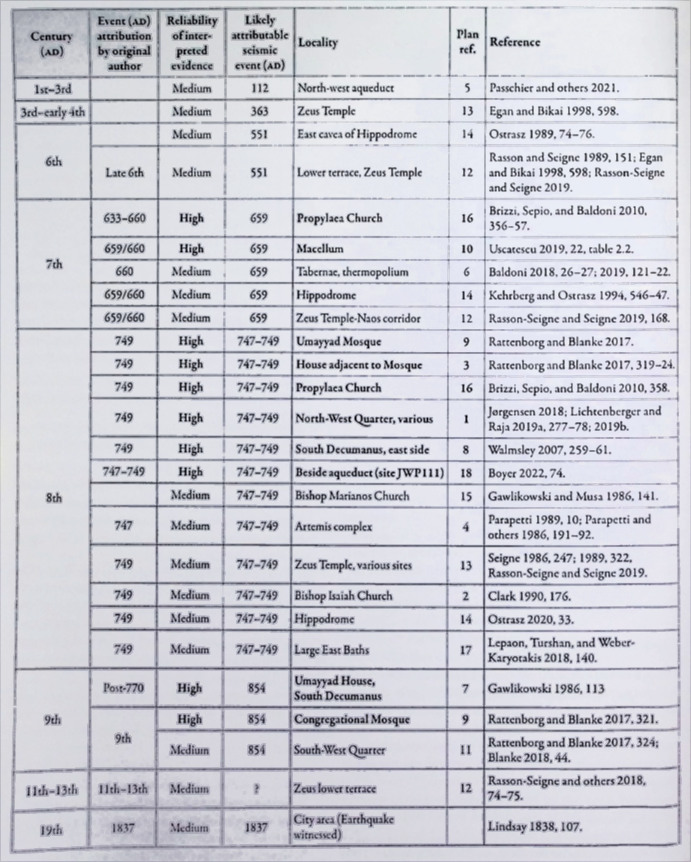 Table 2.2
List of seismically induced damage recorded in Gerasa where the relaibility of the evidence is considered to be medium or high
Click on Image to open in a new tab
Lichtenberger and Raja (2025)
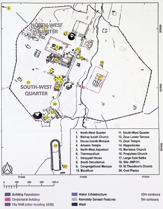 Figure 2.6
Plan of ancient Gerasa showing the location of earthquake-damaged sites referred to in Table 2.2
(after Lichtenberger, Raja, and Stott 2019.fig.2)
Click on Image to open in a new tab
Lichtenberger and Raja (2025)
- from Lichtenberger and Raja (2025)
- Fig. 2.6 Map of seismic damage
in Jerash between the 1st and 19th centuries CE from Lichtenberger and Raja (2025)
Figure 2.6
Plan of ancient Geras showing the location of earthquake-damaged sites referred to in Table 2.2
(after Lichtenberger, Raja, and Stott 2019.fig.2)
Click on Image to open in a new tab
Lichtenberger and Raja (2025)
| Century (AD) | Event (AD) attribution by original author |
Reliability of interpreted evidence |
Likely attributable seismic event (AD) |
Locality | Plan ref. | Reference |
|---|---|---|---|---|---|---|
| 1st–3rd | Medium | 112 | North-west aqueduct | 5 | Passchier and others 2021. | |
| 3rd–early 4th | Medium | 363 | Zeus Temple | 13 | Egan and Bikai 1998, 598. | |
| 3rd–early 4th | Medium | 551 | East cavea of Hippodrome | 14 | Ostrasz 1989, 74–76. | |
| 6th | Late 6th | Medium | 551 | Lower terrace, Zeus Temple | 12 | Rasson and Seigne 1989, 151; Egan and Bikai 1998, 598; Rasson-Seigne and Seigne 2019. |
| 7th | 633–660 | High | 659 | Propylaea Church | 16 | Brizzi, Seipo, and Baldoni 2010, 356–57. |
| 7th | 659/660 | High | 659 | Macellum | 10 | Uscatescu 2019, 22, table 2.2. |
| 7th | 660 | Medium | 659 | Taberna, thermopolium | 6 | Baldoni 2018, 26–27; 2019, 121–22. |
| 7th | 659/660 | Medium | 659 | Hippodrome | 14 | Kehrberg and Ostrasz 1994, 546–47. |
| 7th | 659/660 | Medium | 659 | Zeus Temple–Naos corridor | 12 | Rasson-Seigne and Seigne 2019, 168. |
| 8th | 749 | High | 747–749 | Umayyad Mosque | 9 | Rattenborg and Blanke 2017. |
| 8th | 749 | High | 747–749 | House adjacent to Mosque | 3 | Rattenborg and Blanke 2017, 319–24. |
| 8th | 749 | High | 747–749 | Propylaea Church | 16 | Brizzi, Seipo, and Baldoni 2010, 358. |
| 8th | 749 | High | 747–749 | North-West Quarter, various | 1 | Jørgensen 2018; Lichtenberger and Raja 2019a, 277–78; 2019b. |
| 8th | 749 | High | 747–749 | South Decumanus, east side | 8 | Walmsley 2007, 259–61. |
| 8th | 747–749 | High | 747–749 | Beside aqueduct (site JWP111) | 18 | Boyce 2022, 74. |
| 8th | Medium | 747–749 | Bishop Marianos Church | 15 | Gawlikowski and Musa 1986, 141. | |
| 8th | 747 | Medium | 747–749 | Artemis complex | 4 | Parapetti 1989, 10; Parapetti and others 1986, 191–92. |
| 8th | 749 | Medium | 747–749 | Zeus Temple, various sites | 13 | Seigne 1986, 247; 1989, 322; Rasson-Seigne and Seigne 2019. |
| 8th | 749 | Medium | 747–749 | Bishop Isaiah Church | 2 | Clark 1990, 176. |
| 8th | 749 | Medium | 747–749 | Hippodrome | 14 | Ostrasz 2020, 33. |
| 8th | 749 | Medium | 747–749 | Large East Baths | 17 | Lepaon, Turshan, and Weber-Karyotakis 2018. |
| 9th | Post-770 | High | 854 | Umayyad House, South Decumanus | 7 | Gawlikowski 1986, 113. |
| 9th | 9th | High | 854 | Congregational Mosque | 9 | Rattenborg and Blanke 2017, 321. |
| 9th | 9th | Medium | 854 | South-West Quarter | 11 | Rattenborg and Blanke 2017, 324; Blanke 2018, 44. |
| 11th–13th | 11th–13th | Medium | ? | Zeus lower terrace | 12 | Rasson-Seigne and others 2018, 74–75. |
| 19th | 1837 | Medium | 1837 | City area (Earthquake witnessed) | Lindsay 1838, 107. |
- from Lichtenberger and Raja (2025)
- Fig. 2.6 Map of seismic damage
in Jerash between the 1st and 19th centuries CE from Lichtenberger and Raja (2025)
Figure 2.6
Plan of ancient Geras showing the location of earthquake-damaged sites referred to in Table 2.2
(after Lichtenberger, Raja, and Stott 2019.fig.2)
Click on Image to open in a new tab
Lichtenberger and Raja (2025)
Table 2.2List of seismically induced damage recorded in Gerasa where the relaibility of the evidence is considered to be medium or high
Click on Image to open in a new tab
Lichtenberger and Raja (2025)
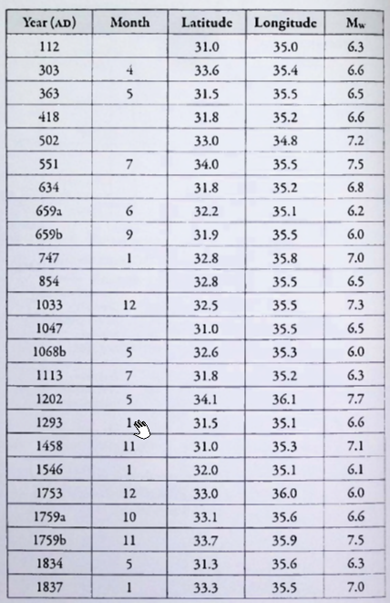 Table 2.11
List of seismic events with median epicentres within a 200 km radius of Gcrasa (Jerash) between 31 BC and AD 1900 with movement magnitude (Mw) > 6.0 (data from Grigoratos and others 2020).
Click on Image to open in a new tab
Lichtenberger and Raja (2025)
- Ecclesiastical complex at Jerash including the Church of St. Theodore
from Moralee (2006)
 Fig. 1
Ecclesiastical complex at Gerasa, adapted from Beat Brenk et al., "Neue Forschungen zur Kathedrale von Gerasa: Probleme der Chronologie und der Vorgângerbauten," ZDPV 112 (1996): 139-55, fig. 1.
Moralee (2006)
The transfer of the capital from Damascus to Baghdad, the growing insecurity of the country, and a series of disastrous earthquakes led ultimately to the desertion of the place. In the nature of the case we cannot say precisely when this happened. Fractured stones, tumbled columns and many signs of hastily interrupted activities are evidence of the earthquake shocks. Coins and other datable objects show that there was life here until the middle of the eighth century at least and probably longer. In 1122 A.D. William of Tyre mentions the city as having been long deserted, and though it was then reoccupied for a short time, Yaqut describes it as again deserted in the next century.Kraeling, C. (1938:260)
Church of St. Theodore - AtriumKraeling, C. (1938:282)
The west wall of the atrium was built of very massive stones, many of them dangerously dislocated by earthquake shocks. It ran alongside a small street which formed the western limit of the complex. A triple entrance only approximately in the center of this wall led into an entrance hall which was paved with mosaics, and from this three long steps descended into the open court. The court had porticoes on three sides only, the north, east and south: the columns in the porticoes had Ionic capitals. Some of the columns may have been moved here from the Fountain Court when it was reconstructed.
Churches of St. John the Baptist, St. George and SS Cosmas and DamianusRussell (1985)
2. The atrium. The atrium was rhomboidal in plan, much longer from north to south than from east to west. On the east side there was a colonnade of 14 Corinthian columns on a low stylobate. The columns, many of which were obviously displaced, vary in diameter, and the capitals found in this area are very miscellaneous in character (Plate XLVI, b). The colonnade apparently never reached beyond the central doors in the parecclesia, but the walk was continued as shown in the plan (Plan XX XVII). The walk was paved with red and white mosaics of which little remains; enough is preserved, however, to show that there were different patterns in front of each church. Before the final desertion of Gerasa the atrium and colonnade, like those in St. Theodore’s and St. Peter’s, were occupied by squatters who built walls in front of and between the columns; the pottery, glass and bronze articles found in their rooms suggest that the place was finally abandoned in haste, possibly after the earthquake in 746 A. D. This occupation explains the disappearance of the steps leading into the churches and the condition of the atrium mosaics
At Jerash, this earthquake apparently brought an end to the impoverished "squatter" occupation in the Church of St. Theodore (Crowfoot 1929: 25. 1938: 221) and parts of the churches of St. John the Baptist. St. George, and SS. Cosmas and Damianus (Crowfoot 1938: 242, 244).Walmsley(2013:86-87) described seismic destruction in Jerash in the mid 8th century CE.
Its many churches continued in use right through the Umayyad period, only to be suddenly destroyed in the mid-eighth century by a violent act of nature — an earthquake — as graphically revealed during the excavation of the Church of St Theodore by the Yale Joint Mission in the 1930s (Crowfoot 1938: 223-4). The severity of this seismic event was recently confirmed by the discovery of a human victim entombed in a collapsed building along with his mule, some possessions and a hoard of 143 silver dirhams of mostly eastern origin, the last of which was minted in the year of the earthquake.As Walmsley(2013:86-87) did not cite a source for the human victim and mule found inside a collapsed building, it is not known if this occurred in the Church of Saint Theodore.
Barnes et al (2006:306) noted the presence of 749 CE archaeoseismic evidence in Jerash in the Church of Bishop Isaiah
The excavation of the at Jarash, west of North Theatre, has revealed similar roof tiles, both the tegulae and imbrices, in the destruction layer of the church dated to the earthquake of 749 AD (Clark et al. 1986: 313).Clark, V. A., Bowsher, J. M. C. and Stewart, J. D. 1986 The Jerash North Theatre. Architecture and Archaeology 1982-1983. Pp. 205-302 in F. Zayadine (ed.), Jerash Archaeological Project 1, 1981-1983. Amman: Department of Antiquities.
Walmsley (2007) reports the following archeoseismic evidence at Jerash (Gerasa)
At Gerasa the evidence is less categorical but suggests at least sections of the town - but not perhaps all of it - were damaged in A.D. 749. Thick levels of building wreckage were encountered above the cathedral steps, in the church of St Theodore and the group of three churches dedicated to SS Cosmas and Damianus, St George and St John the Baptist, which the Yale Mission attributed to earthquake activity in the 8th c.29 In 2004, further graphic evidence for the impact of the earthquake at Gerasa was recovered from a room on the eastern part of the south decumanus, in which was found the crushed skeletal remains of a human victim and a mule accompanied by a hoard of 148 silver dirhams, of which three were minted in 130 A.H. (A.D. 747/48).
Footnotes
29 Kraeling (1938) 208, 223, 247–49.