Ramat Rachel
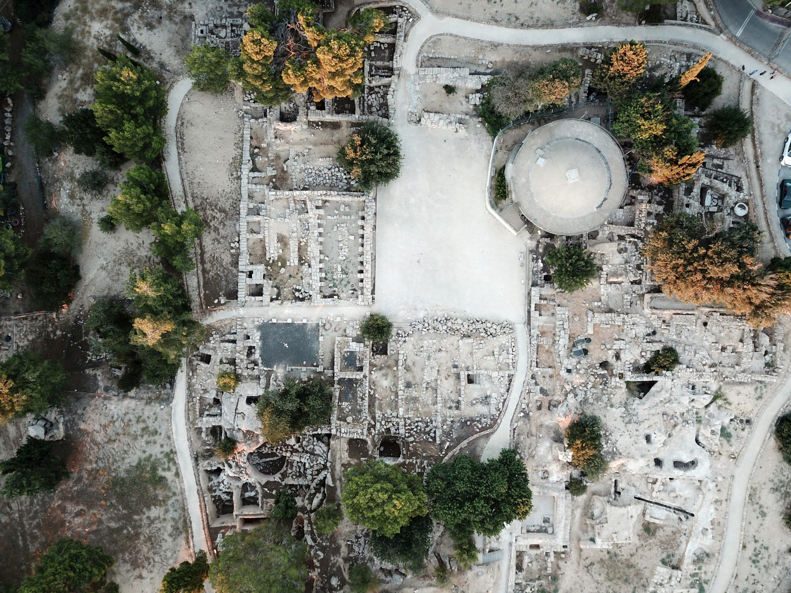
 Aerial View of Ramat Rachel
Click on Image for high resolution magnifiable image
Used with permission from Biblewalks.com
| Transliterated Name | Source | Name |
|---|---|---|
| Ramat Rachel | Hebrew | רָמַת רָחֵל |
| Khirbet es-Sallah | Arabic | كهيربيت يسءساللاه |
| Bethofor | Byzantine Name | |
| Pathofor | Variant of Byzantine Name | |
| Betheabra | Variant of Byzantine Name | |
| Kathisma | Incorrect Byzantine Name | |
| MMST | Theorized Ancient Name |
- Fig. 1 - Location Map
from Aharoni (1956)
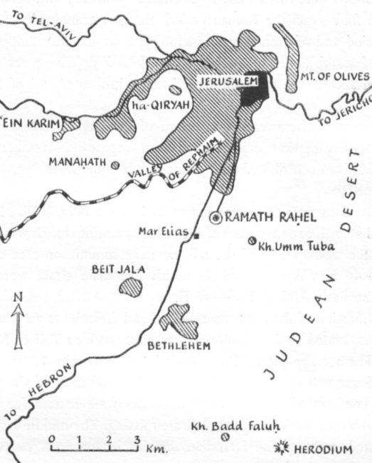 Figure 1
Ramath Rahel and its vicinity
(Drawn by M. Seydewitz-Karmon)
Aharoni (1956) - Fig. 1 - Location Map
from Lipschitz et al (2011)
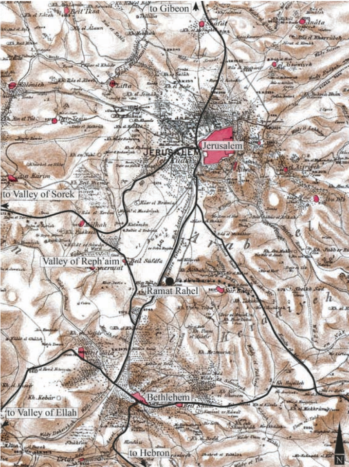 Figure 1
Map of Ramat Raḥel and its vicinity, based on a map prepared by the Palestine Exploration Fund
(Adapted by Ido Koch)
Lipschitz et al (2011) - Fig. 1 - Location Map
from Avner (2016)
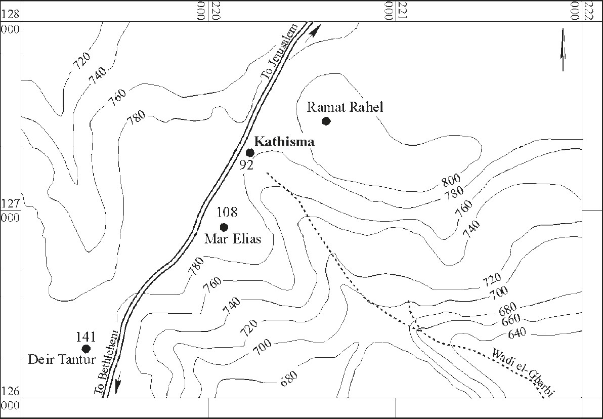 Figure 1.1
Location Map
Avner (2016) - Fig. 9 - Topographic Map
of the Ramat Raḥel hill prior to the First Building Phase from Lipschitz et al (2011)
 Figure 9
The Ramat Raḥel hill prior to the First Building Phase
(Prepared by Nirit Kedem)
Lipschitz et al (2011)
- Ramat Rachel in Google Earth
 Ramat Rachel
click on image to explore this site on a new tab in Google Earth - Ramat Rachel on govmap.gov.il
 Ramat Rachel on govmap.gov.il
click on image to explore this site on a new tab in govmap.gov.il - Annotated Aerial View of
Ramat Rachel and surroundings from Biblewalks.com
 Annotated Aerial View of Ramat Rachel and surroundings
Used with permission from Biblewalks.com - Aerial View of Ramat Rachel
from Biblewalks.com
 Aerial View of Ramat Rachel
Click on Image for high resolution magnifiable image
Used with permission from Biblewalks.com
- Fig. 4 - Excavation areas of
Aharoni (1954-1962) from Lipschitz et al (2011)
 Figure 4
The areas excavated by Aharoni from 1954 until 1962
Illustration prepared by Benjamin Arubas and adapted by Ido Koch
Lipschitz et al (2011) - Fig. 3.1 - The grid laid
by Aharoni in 1954 from Aharoni (1962 - 1964)
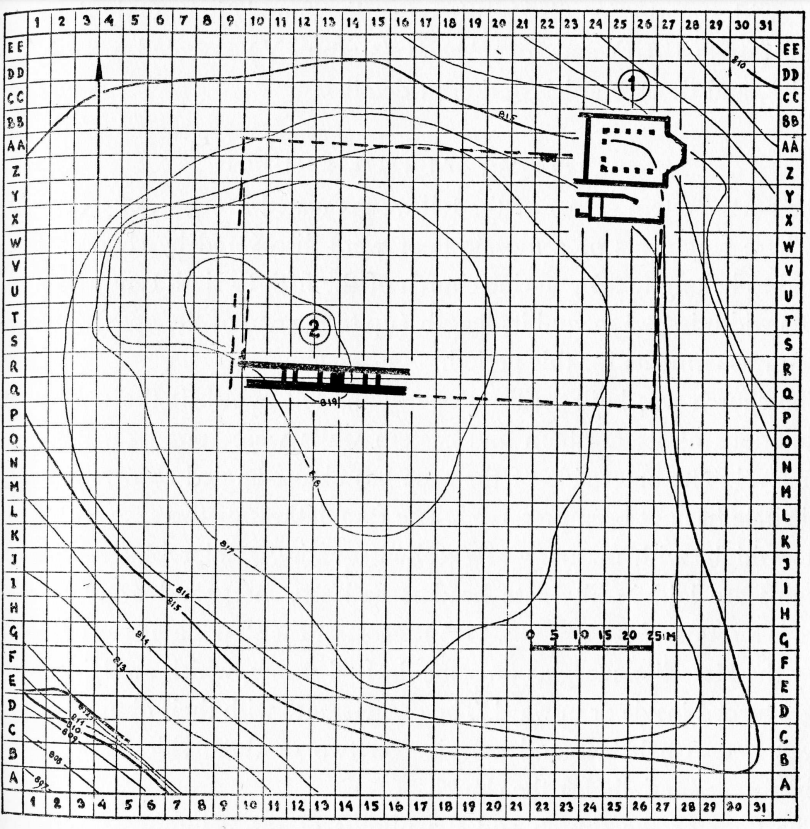 Figure 3.1
The grid laid by Aharoni in 1954
Aharoni (1962 - 1964) - Fig. 3.2 - Aharoni’s excavations
by season, as suggested by Gadot from Aharoni (1962 - 1964)
 Figure 3.2
Aharoni’s excavations by season, as suggested by Gadot
Aharoni (1962 - 1964)
- Fig. 4 - Excavation areas of
Aharoni (1954-1962) from Lipschitz et al (2011)
Figure 4
The areas excavated by Aharoni from 1954 until 1962
Illustration prepared by Benjamin Arubas and adapted by Ido Koch
Lipschitz et al (2011) - Fig. 3.1 - The grid laid
by Aharoni in 1954 from Aharoni (1962 - 1964)
Figure 3.1
The grid laid by Aharoni in 1954
Aharoni (1962 - 1964) - Fig. 3.2 - Aharoni’s excavations
by season, as suggested by Gadot from Aharoni (1962 - 1964)
Figure 3.2
Aharoni’s excavations by season, as suggested by Gadot
Aharoni (1962 - 1964)
- Fig. 8 - Excavation areas of
the Renewed Expedition to Ramat Rahel from Lipschitz et al (2011)
 Figure 8
Excavation areas of the Renewed Expedition to Ramat Rahel. Photo by Sky-View, adapted by Ido Koch
Lipschitz et al (2011) - Fig. 10 - Plan of the
Ramat Rahel edifice in Building Phases 1–3 from Lipschitz et al (2011)
 Figure 10
The plan of the Ramat Raḥel edifice in Building Phases 1–3
(Prepared by Benjamin Arubas)
Lipschitz et al (2011) - Fig. 6 - Plan of the
Roman and Byzantine buildings from Soennecken (2006)
 Figure 6
plan of Roman and Byzantine buildings
Soennecken (2006) - Fig. 7 - Plan of the
church and adjoining room from Soennecken (2006)
 Figure 7
plan of the church and adjoining rooms
Soennecken (2006)
- Fig. 8 - Excavation areas of
the Renewed Expedition to Ramat Rahel from Lipschitz et al (2011)
Figure 8
Excavation areas of the Renewed Expedition to Ramat Rahel. Photo by Sky-View, adapted by Ido Koch
Lipschitz et al (2011) - Fig. 10 - Plan of the
Ramat Rahel edifice in Building Phases 1–3 from Lipschitz et al (2011)
Figure 10
The plan of the Ramat Raḥel edifice in Building Phases 1–3
(Prepared by Benjamin Arubas)
Lipschitz et al (2011) - Fig. 6 - Plan of the
Roman and Byzantine buildings from Soennecken (2006)
Figure 6
plan of Roman and Byzantine buildings
Soennecken (2006) - Fig. 7 - Plan of the
church and adjoining room from Soennecken (2006)
Figure 7
plan of the church and adjoining rooms
Soennecken (2006)
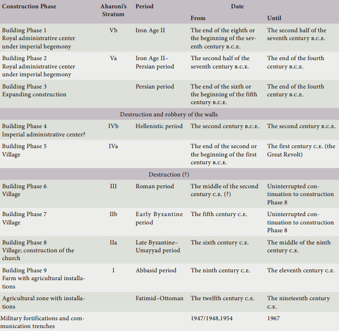
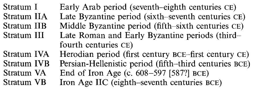 Stratigraphy of Ramat Rachel
Stern et al (1993 v. 4)
| Effect | Location | Image(s) | Description |
|---|---|---|---|
| Collapsed Walls and Fire | diverse areas of the site
Figure 6 plan of Roman and Byzantine buildings Soennecken (2006) |
collapse and conflagration in diverse areas of the site- Lipschitz et al (2011) |
|
| Collapsed Walls | various parts of Byzantine buildings
Figure 6 plan of Roman and Byzantine buildings Soennecken (2006) |
there are significant signs of various parts of Byzantine buildings giving way- Lipschitz et al (2011) |
|
| Collapsed Walls | northern wall of the church
Figure 6 plan of Roman and Byzantine buildings Soennecken (2006)
Figure 7plan of the church and adjoining rooms Soennecken (2006) |
the northern wall of the church collapsed- Lipschitz et al (2011) |
|
| Fire | mosaic floor of the church
Figure 6 plan of Roman and Byzantine buildings Soennecken (2006)
Figure 7plan of the church and adjoining rooms Soennecken (2006) |
Aharoni notes indications of burning on the mosaic floor of the church- Lipschitz et al (2011) |
| Effect | Location | Image(s) | Description |
|---|---|---|---|
| Collapsed Walls and Stone Tumble | Area D1
Figure 8 Excavation areas of the Renewed Expedition to Ramat Rahel. Photo by Sky-View, adapted by Ido Koch Lipschitz et al (2011) |
A massive stone collapse had covered the floors of the different architectural units- The Tel Aviv - Heidelberg Joint Project - The 2006 and 2007 seasons at Ramat Rahel |
|
| Broken Pottery | Area D1
Figure 8 Excavation areas of the Renewed Expedition to Ramat Rahel. Photo by Sky-View, adapted by Ido Koch Lipschitz et al (2011) |
many broken pottery vessels- The Tel Aviv - Heidelberg Joint Project - The 2006 and 2007 seasons at Ramat Rahel |
- Modified by JW from Fig. 6 of Soennecken (2006)
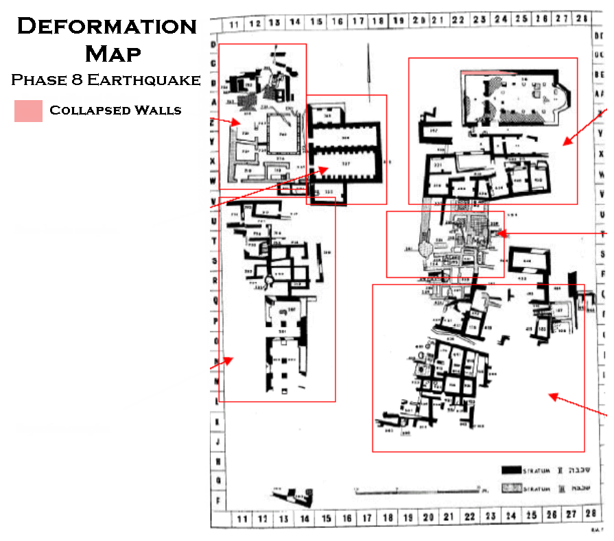 Deformation Map
modified by JW from Fig. 6 of Soennecken (2006)
- Earthquake Archeological Effects chart
of Rodríguez-Pascua et al (2013: 221-224)
 Earthquake Archeological Effects (EAE)
Rodríguez-Pascua et al (2013: 221-224)
| Effect | Location | Image(s) | Description | Intensity |
|---|---|---|---|---|
| Collapsed Walls and Fire | diverse areas of the site
Figure 6 plan of Roman and Byzantine buildings Soennecken (2006) |
collapse and conflagration in diverse areas of the site- Lipschitz et al (2011) |
VIII + | |
| Collapsed Walls | various parts of Byzantine buildings
Figure 6 plan of Roman and Byzantine buildings Soennecken (2006) |
there are significant signs of various parts of Byzantine buildings giving way- Lipschitz et al (2011) |
VIII + | |
| Collapsed Walls | northern wall of the church
Figure 6 plan of Roman and Byzantine buildings Soennecken (2006)
Figure 7plan of the church and adjoining rooms Soennecken (2006) |
the northern wall of the church collapsed- Lipschitz et al (2011) |
VIII + |
- Earthquake Archeological Effects chart
of Rodríguez-Pascua et al (2013: 221-224)
Earthquake Archeological Effects (EAE)
Rodríguez-Pascua et al (2013: 221-224)
| Effect | Location | Image(s) | Description | Intensity |
|---|---|---|---|---|
| Collapsed Walls and Stone Tumble | Area D1
Figure 8 Excavation areas of the Renewed Expedition to Ramat Rahel. Photo by Sky-View, adapted by Ido Koch Lipschitz et al (2011) |
A massive stone collapse had covered the floors of the different architectural units- The Tel Aviv - Heidelberg Joint Project - The 2006 and 2007 seasons at Ramat Rahel |
VIII + | |
| Broken Pottery | Area D1
Figure 8 Excavation areas of the Renewed Expedition to Ramat Rahel. Photo by Sky-View, adapted by Ido Koch Lipschitz et al (2011) |
many broken pottery vessels- The Tel Aviv - Heidelberg Joint Project - The 2006 and 2007 seasons at Ramat Rahel |
VII + |