551 CE Beirut Earthquake
Afternoon 9 July 551 CE
by Jefferson Williams

 Fig. 2
Proposed isoseismal maps of the 551 AD earthquake constructed by Ordinal Kriging prediction.
- (left) isoseismals interpolated on the basis of macroseismic data only
- (right) isoseismals interpolated on the basis of all data points of macroseismic, environmental and tsunami effects.
CC BY 4.0 Deed - Salamon et al. (2024)
Introduction & Summary
Textual Evidence
| Text (with hotlink) | Original Language | Religion | Date of Composition | Location Composed | Notes |
|---|---|---|---|---|---|
| Textual Evidence Summary | |||||
| Intensity Estimates | |||||
| Chronographia by Johannes Malalas | Greek | Christian (Orthodox Byzantium) | ~530s to 565 CE | Probably Antioch and Constantinople | |
| The Histories by Agathias of Myrina | Greek | between 578 and 582 CE | Constantinople | ||
| The Life of Symeon of the Wondrous Mountain | Syriac | ||||
| Ecclesiastical History by John of Ephesus | Syriac | Syriac Orthodox Church | ca. 588 CE | ||
| The Anonymous Itinerarium (erroneously) attributed to Antoninus of Piacenza | Latin | 6th century CE | |||
| Romanos Melodos | Greek | Christian - convert from Judaism | 6th century CE ? | Constantinople ? | |
| Fragmenta Historica Tusculana | Greek | ||||
| Chronicle of Zuqnin by Pseudo-Dionysius of Tell-Mahre | Syriac | Eastern Christian | 750-775 CE | Zuqnin Monastery | |
| Chronicle of Theophanes | Greek | Orthodox (Byzantium) | 810-814 CE | Vicinity of Constantinople | |
| Georgius Monachus | Greek | Last half of 9th c. CE | Constantinople | ||
| Synopsis Historion by Cedrenus | Greek | Orthodox (Byzantium) | 1050s CE | Anatolia | |
| Chronicle by Michael the Syrian | Syriac | Syriac Orthodox Church | late 12th century CE | Probably at the Monastery of Mar Bar Sauma near Tegenkar, Turkey | |
| Chronicon by Bar Hebraeus | Syriac | Syriac Orthodox Church | 13th century CE | Jazira ? Persia ? | |
| Text (with hotlink) | Original Language | Religion | Date of Composition | Location Composed | Notes |
Archaeoseismic Evidence
| Location (with hotlink) | Status | Intensity | Notes |
|---|---|---|---|
| Beirut | probable | ≥ 8 | Scattered evidence for seismic destruction shows up in various reports. |
| Msaylḥa Bridge | possible | Petersen (2020:200-201) speculated that an early Roman version of the Msaylha Bridge may have collapsed in the 551 CE earthquake. Although the Msaylha Bridge shows evidence of an earlier, perhaps Roman, construction, none of this evidence is dated nor is a seismic origin for an earlier destruction affirmed. | |
| Hosn Niha | possible |
Paturel, S. (2019:185) reports potential archaeoseismic evidence at the Sanctuary of Hosn Niha in the Bekka Valley.Late Roman: Church |
|
| Bosra | possible | ≥ 8 | Major Modifications Earthquake (?) - 6th century CE -
Dentzer et al. (2002:91) documented major architectural modifications to the large centrally planned church at
Bosra (also referred to as the cathedral, central church, or large church), originally constructed in the late
5th century CE. Ceramic evidence dated these alterations to the end of the 6th century CE, and the authors suggest
that the reconstruction was likely triggered by seismic damage from a mid-6th century earthquake,
potentially the 551 CE Beirut Quake.
Dentzer et al. (2002:91 n. 49) further observed that such an earthquake might
explain the cracks in the ground embankment observed near the south-eastern exedra. Dentzer et al. (2002:92) further speculated that the large pipe crossing the central church may have been constructed during the late 6th century CE modifications. |
| Jerash - Introduction | possible - needs investigation | Russell (1985) reports that
Crowfoot (1938: 233) suggested that at Jerash the mid-6th century construction of the Propylae Church occurred after the 551 earthquake had caused the collapse and abandonment of the bridge whose approach had been blocked by this church. |
|
| Mount Nebo | possible | Piccirillo (1982) noted that the memorial to Moses underwent a complete reconstruction from the
the middle of the 6th century to the first years of the 7thcentury CE. |
|
| Gush Halav | possible - debated chronology | Meyers, Strange, Meyers, and Hanson (1979) attributed seismic destruction at the end of Stratum VII phase b to the 551 CE Beirut Quake however their chronology is debated. Magness (2001a) performed a detailed examination of the stratigraphy presented in the final report of Meyers, Meyers, and Strange (1990) and concluded, based on numismatic and ceramic evidence, that a synagogue was not built on the site until no earlier than the second half of the fifth century. Meyers, Strange, Meyers, and Hanson (1979) dated construction of the first sysnagogue on the site to ~250 CE. While Magness (2001a) agreed that earthquake destruction evidence was present in the excavation, she dated the destruction evidence to some time after abandonment of the site in the 7th or 8th centuries CE. Strange (2001) and Meyers (2001) went on to rebut Magness (2001a) to which Magness (2001b) responded again. One point of agreement is that earthquake destruction evidence does appear to be present. Although based on epicentral distance and the magnitude of the earthquake, is very possible that Gush Halav suffered seismic destruction during the 551 CE Beirut Quake, the chronology from this excavation is not clear. | |
| Sepphoris | possible | ≥ 8 | 6th century CE Earthquake -
Waterman et al. (1937:34) speculated on the demise of a building on the northwest corner of the summit which was exposed in Trench S II and
which
Waterman et al. (1937:34) suggested may have been a Basilica.
Waterman et al. (1937:34) noted that the architectural remains (shafts and capitals of the columns, parts of the masonry, and the like) all seem to be fallen in one line running east-westand suggested that a 6th century CE earthquake may have caused this damage. Waterman et al. (1937:34) noted that similar east-west oriented collapse was discovered at the synagogue at Beit-Alpha. Waterman et al. (1937:31) did not provide dates for the demise of the "basilica" and merely noted that the summit seems to have been abandoned after the 6th century CE and was not occupied again until the Crusaders built a fort on the Summit. Although the synagogue at Beit-Alpha did exhibit east-west oriented collapse which appears to have a seismic origin, the dating of this damage to the 6th century CE is not so precise. The excavator Sukenik (1932) merely provided a terminus post quem of the early 6th century CE for the collapse. |
| Deir 'Aziz | possible | ≥ 8 | Zingboym (2011) suggest that the trough of the spring structure downslope from the synagogue shifted 8 cm. to the south during an earthquake or landslide - probably due to the 551 CE Beirut Quake. |
| Areopolis | unlikely | Zayadine (1971) published a translation of a dedicatory inscription at Areopolis which was found out of context and re-used in a structure (Rucker and Niemi, 2010). The inscription referred to an earthquake which struck Areopolis before 597 CE (likely within a decade or so). This indicates that any archeoseismic evidence from Areopolis which is dated with no more precision than 6th century CE was likely due to the Inscription at Areopolis Quake and not to the distant 551 CE Beirut Quake. Further details can be found in the Archeoseismic Evidence section of the Inscription at Areopolis Quake. | |
| el-Lejjun | unlikely | Although Parker (2006) attributed the 3rd earthquake to the 551 CE Beirut Quake, this is unlikely as the epicenter was far away - near Beirut. One of the sources for the 551 CE Beirut Quake (The Life of Symeon of the Wondrous Mountain) states that damage was limited south of Tyre and there are no reports of earthquake destruction in Jerusalem which is 121 km. closer to the epicenter than el-Lejjun. The most likely candidate for this earthquake is the Inscription at Areopolis Quake which struck Aeropolis - a mere ~12 km. from el-Lejjun - in the late 6th century - before 597 CE. | |
| Damietta | possible - needs investigation | Based on the contemporaneous account of Myrinaei Historiarum by Agathias which described seismic shaking in the Nile Delta during to the 551 CE Beirut Quake, Damietta, which is the closest part of the Delta to Beirut and may be subject to a site effect due to liquefaction, could contain archaeological evidence of 551 CE seismic destruction. | |
| Location (with hotlink) | Status | Intensity | Notes |
Tsunamogenic Evidence
| Location (with hotlink) | Status | Intensity | Notes |
|---|---|---|---|
| Beirut | some evidence | ||
| Tyre | no evidence | ||
| Sidon | no evidence | ||
| Byblos | no evidence | Although tsunamigenic evidence has not been found for a 6th century CE event, Morhange et al (2006:91) reported the possibility of 10th or 11th century CE coastal uplift in Byblos. | |
| Caesarea and Jisr al-Zakra | indeterminate | Goodman-Tchernov et al (2009) identified tsunamites in cores taken immediately offshore of the harbor of Caesarea which Goodman-Tchenov and Austin (2015) dated to the 5th - 8th century CE and associated with tsunamis generated by the Beirut Quake of 551 CE and one of the Sabbatical Year Quakes. Although earlier works assigned this 5th - 8th century tsunamite deposit solely to the Beirut Quake of 551 CE, later revisions assigned this offshore deposit mostly to one of the Sabbatical Year Quakes with the suggestion that the Sabbatical Year Quake tsunami deposit contained some reworked tsunamites from the 551 CE Beirut Quake. | |
| Location (with hotlink) | Status | Intensity | Notes |
Paleoseismic Evidence
| Location (with hotlink) | Status | Intensity | Notes | |||||||||||||||||||||||||
|---|---|---|---|---|---|---|---|---|---|---|---|---|---|---|---|---|---|---|---|---|---|---|---|---|---|---|---|---|
| al-Harif Aqueduct | unlikely | ≥ 7 | Sbeinati et. al. (2010) report a seismic event X which they dated to 335 AD ± 175 years at a displaced aqueduct at al-Harif, Syria (close to Masyaf, Syria). The 551 Beirut Quake is slightly outside modeled ages. | |||||||||||||||||||||||||
| Tabarja Benches | probable | Mw = ~7.4-7.6 | Elias et al (2007) examined uplifted benches on the Lebanese coast between Sarafand and Tripolis; some in the vicinity of Tabarja (~20 km. NE of Beirut). They estimated ~80 cm. of uplift took place on the lowest bench (B1) in the 6th century CE which they attributed to the 551 CE Beirut Quake. From their geophysical surveys, they also discovered a previously unknown thrust fault system offshore which they called the Mount Lebanon Thrust. They surmised that the 551 CE Beirut Quake was a result of fault movement on these thrust faults. | |||||||||||||||||||||||||
| Qiryat-Shemona Rockfalls | possible to unlikely | Kanari, M. (2008) examined rockfalls in
Qiryat-Shemona which were attributed to earthquakes.
Optically stimulated luminescence (OSL) dating was performed on soil samples beneath the fallen rocks.
Kanari et al (2019) proposed that
rockfalls QS-3 and QS-11 were most likely triggered by the northern Cyril Quake of 363 CE. Their discussion is quoted below:
QS-3 (1.6±0.1 ka) and QS-11 (1.7±0.2 ka) fit the historical earthquakes of 363 and 502 CE, and only lack 40 years in error margin to fit the one of 551 CE. Since the 502 CE earthquake was reported on shoreline localities only in the DST area, we find the 363 CE earthquake to be a better rockfall-triggering candidate. We suggest that the two ages are clustered around one of these earthquakes, hence suggesting they represent one rockfall event in the 363 CE earthquake. However, we cannot completely rule out the possibility that these were two separate rockfall events, both triggered by large earthquakes in 363 and 502/551 CE. |
||||||||||||||||||||||||||
| Bet Zayda | probable | ≥ 7 | Wechsler at al. (2014) may have seen evidence for this earthquake in Event CH3-E2 (Modeled Age 505-593 CE). | |||||||||||||||||||||||||
| Dead Sea - Seismite Types | n/a | n/a |
The table below shows projected PGA and Intensity at 3 Dead Sea Sites
and 1 Araba site for the 551 CE Beirut Earthquake
where the Magnitude (7.5) and Epicenter come from
Elias et al (2007).
Also included are calculated intensities for the seismites in question at the sites. En Feshka is the only site where projected intensity from the
551 CE Beirut Earthquake matches up well with the estimated
Intensity from the seismite. There is a mismatch at En Gedi and a large mismatch at Nahal Ze'elim. The
closer late 6th century CE Inscription at Areopolis Quake
seems a better candidate than the 551 CE Beirut Earthquake at En Gedi,
Nahal Ze 'elim, and in the Taybeh Trench. However, if one considers that
Lu et al (2020a) estimated a minimum PGA of 0.13 g and
Williams (2004)
estimated a minimum PGA of 0.23 g to generate a seismite in the Dead Sea, it isn't impossible
that the 551 CE Beirut Earthquake generated seismites at En Feshka,
En Gedi, and Nahal Ze'elim. A calculator is provided for experimentation.
|
|||||||||||||||||||||||||
| Dead Sea - En Feshka | possible | 5.6-7.0 | Kagan et. al. (2011) identified a 1 cm. thick "seismite" at a depth of 186.5 cm. (Modeled Ages ±1σ - 591 AD ± 48, ±2σ - 579 AD ± 103) which they assigned to the 551 CE Beirut Quake. However, the Inscription at Areopolis Quake appears to be a better match. It better matches the date range and appears to have had a much closer epicenter. That said, the "seismite" was labeled as questionable; indicating that it may not have been a result of seismic activity. | |||||||||||||||||||||||||
| Dead Sea - En Gedi | unlikely to possible | 7.9-8.8 | Migowski et. al. (2004) assigned a 551 CE date to a 0.3 cm. thick Type 4 mixed layer seismite at a depth of 220.33 cm. (2.2033 m) in the 1997 GSI/GFZ core in En Gedi. | |||||||||||||||||||||||||
| Dead Sea - Nahal Ze 'elim | unlikely | 8.4-9.3 | At site ZA-2, Kagan et. al. (2011) assigned a 551 CE date to a 17 cm. thick brecciated seismite at a depth of 315 cm. (Modeled Ages ±1σ - 537 AD ± 70, ±2σ - 540 AD ± 88). Due to distance from the epicenter, this date assignment for such a thick and brecciated seismite is extremely unlikely. The Inscription at Areopolis Quake is a better candidate. | |||||||||||||||||||||||||
| Araba - Introduction | n/a | n/a | n/a | |||||||||||||||||||||||||
| Araba - Taybeh Trench | unlikely | Event E3 (Modeled Age 551 AD ± 264) in the Taybeh Trench (LeFevre et al., 2018) matches well with a 551 CE date however the spread of ages for this event is quite large and a number of other earthquakes with closer epicenters are better candidates for causing the deformation seen in Event E3 (e.g the Inscription at Areopolis Quake). | ||||||||||||||||||||||||||
| Araba - Qatar Trench | no evidence | Klinger et. al. (2015) didn't date any events which match with this earthquake. The closest event would likely be Event E6 which was dated to 251 CE ± 251. | ||||||||||||||||||||||||||
| Location (with hotlink) | Status | Intensity | Notes |
Notes
Salamon et al. (2024) engaged in database preparation and synthesis which led to an isoseismal map followed by seismic modeling and tsunami simulation as outlined below
Intensity Data Points
- Database preparation and synthesis
- Search, collect and construct a database of macroseismic, tsunami and environmen tal effects from documentary data, geomorphological, and geoarchaeological stud ies, and marine surveys
- Assign intensity degrees to the assembled effects
- Identify the potential seismogenic and tsunamigenic sources proposed by previous researchers for the 551 events and define their source parameters
- Assemble bathymetry and topography grid and reconstruct Beirut paleo-coastline at the time of the 551 events.
- Modeling and simulation
- Construct iso-seismal map of the 551 event on the base of the intensities assigned to its various effects
- ACompute the coseismic deformation (Okada 1985) of the proposed sources. Here, Okada’s (1985) half-space elastic deformation theory is used to simulate the static vertical dislocation produced by the rupture of each 551-like earthquake scenario. The derived rupture fault parameters (i.e., location, dimensions, dip, rake, strike and slip) form the input for Okada’s model
- ASelect the most favorable earthquake source that best explains the spread of earth quake effects, including the uplifted marine-cut terraces. This source can also be a tsunamigenic source.
- ASimulate the tsunami generation and wave propagation according to the proposed tsunamigenic sources. The tsunami initial wave is derived by transferring the simu lated coseismic deformation to the free sea surface with the assumption that the sea disturbance mimics the seafloor deformation. This initial wave is then propagated using a validated nonlinear shallow water equations code
- AProduce time series of the tsunami waves at selected locations along the Beirut coast. This approach involves simulating synthetic tsunami waveforms to analyze the temporal evolution of tsunamis in offshore coastal areas
- ASelect the most favorable tsunamigenic source that best explains the reported tsu nami effects. The obtained simulation results (coastal uplift, leading wave, wave height, etc.) are directly compared with the available reports, evidence and observa tions to help infer the best candidate source for the 551 event.
Data points for the database combined intensity scales of EMS-98 macroseismic (Grünthal 1998), PI-2001 tsunami (Papadopoulos and Imamura 2001) and ESI-2007 environmental (Serva et al. 2016) under the same umbrella. These datapoints were compiled into Tables 2-4 as well as Tables SP 1.1, SP 1.2, and SP 1.3 in the Supplemental Appendices. A total of 55 spatial data points were created of which 24 came from reported macroseismic effects, 25 came from environmental effects, and 6 came from tsunami effects. Reliability and uncertainty of assigned intensities were ranked in one of two ways depending on the table. The ranking scales are either High (H), moderate (M), or poor (P) or High (H), moderate (M), or low (L). For details on how these reliability assessments were made, see Salamon et al. (2024)

 Table 2
EMS-98 macroseismic intensities assigned to localities affected by the 551 earthquakes
Salamon et al. (2024)
 Table 3
Intensity degrees assigned to tsunami effects related to the 551 event according to the Papadopoulos and Imamura (2001) tsunami intensity scale
Salamon et al. (2024)

 Table 4
Intensity degrees assigned to environmental effects associated with the 551 event according to the ESI-2007 Scale (Serva et al. 2016)
Salamon et al. (2024)
Salamon et al. (2024) then used an Ordinary Kriging prediction to construct the isoseismal map and locate the potential Imax region (e.g., de Rubeis et al. 2005; Teves-Costa et al. 2019). Two isoseismal maps were created which are described and shown below:
- Fig. 2a (left) is based on macroseismic and EMS-98 intensities only
- Fig. 2b (right) integrates macroseismic, environmental and tsunami effects
(that is, the bins in which pairs of data points are being com pared and inspected) in which the minimum and maximum participating neighboring data points for prediction were set to 2 and 10, respectively. The isoseismal map containing all data points (Fig. 2b to the right) is the preferred interpretation. With the addition of a point representing offshore uplift and a number of points representing coastal uplift, It suggests an offshore epicenter. Bet Zeyda is excluded from the input datapoints likely because the Bet Zeyda event represents a different unconnected fault break.
Fig. 2Proposed isoseismal maps of the 551 AD earthquake constructed by Ordinal Kriging prediction.
- (left) isoseismals interpolated on the basis of macroseismic data only
- (right) isoseismals interpolated on the basis of all data points of macroseismic, environmental and tsunami effects.
CC BY 4.0 Deed - Salamon et al. (2024)
Fault Rupture Scenarios
In Section 3.4, Salamon et al. (2024) discussed possible fault rupture candidates which they summarized in Table 5.
 Table 5
Fault rupture parameters of potential 551 seismogenic sources
Salamon et al. (2024)
| Name | Description |
|---|---|
| MLT and TBJD | MLT and TBJD represent offshore Lebanon sources characterized by parameters that have already been suggested in the published literature (Elias 2006, and Elias et al. 2007; and Faysal et al. 2023). This source strikes more or less parallel to the coast, with a shallow depth, relatively high dip, thrust or transpression mechanism, and considerable magnitude. |
| Roum Fault | We followed Nemer and Meghraoui (2006a, b), who identified 35 km long and shallow, mainly left-lateral strike-slip, fault and estimated an Ms of 7.1 for the 1837 historical event. This source also represents Ambraseys’s (2009) opinion that 551 was pos sibly on land on the Roum fault. In addition, Darawcheh et al. (2000, Figs. 1, 2 in there) located the source on land along a 50 km long trace of the strike-slip Roum fault, even though they mapped the 551 epicenter offshore of Beirut. |
| Lebanon flexure | This source is part of the structural system that thrusts the Lebanon mega-anticline (Fig. 4–2 in Elias 2006). It is a generic analog of the on-land MLT and TBJD and has similar mechanical characteristics. |
| The Kelb-Bikfaya scenario | Dahr el Baidar represents the seismotectonic potential of the E–W-striking normal fault system on-land Lebanon (Hancock and Atiya 1979), as has already been demonstrated by modern activity (Salamon et al. 2003). Its parameters were generalized accordingly to reflect the full rupture of such faults. |
| Kelb-Bikfaya | The Kelb-Bikfaya scenario exhibits yet another structural system that takes part in the deformation process associated with the restraining bend of the DST (see Fig. 2–43 in Elias 2006). This reference was used to characterize the source parameters of the maximal magnitude event. |
| Latakia Ridge | We omitted the Latakia Ridge transpressive scenario (Nemer et al. 2023) for the reasons explained above. The computed coseismic deformation of the MLT and TBJD scenarios (discussed in Sect. 4.1.2) supports the view that the Latakia Ridge contribute negligible uplift of the marine-cut terraces along the Lebanese coast. |
| Bet-Zayda, Jordan Gorge Fault | The Bet-Zayda, Jordan Gorge Fault (proposed by Wechsler et al. 2014), is a segment of the DST and is ~ 100 km south of Beirut and even south of the Roum Fault. Thus, as a strike-slip mechanism, the Bet-Zayda fault is expected to induce an insignificant coseismic effect along the Lebanese coast. |
Rupture candidates were then seismically modeled using Okada’s (1985) half-space elastic equations. Since only the MLT-TBJD scenario (Fig. 2a in the upper left) reproduced the ~80 cm. of coseismic uplift dated to the 551 CE Beirut Quake, it was concluded that this represents the most likely rupture scenario.
 Fig. 3
Modeled coseismic deformation generated by the potential 551 earthquake scenarios (Table 5).
- Mount Lebanon Thrust (MLT)—Tripoli-Batroun-Jounieh-Damour (TBJD)
- Lebanon Flexure
- Kelb Bikfaia Fault
- Roum Fault
- Dahr el Baidar Fault
CC BY 4.0 Deed - Salamon et al. (2024)
Latakia Ridge
The Latakia Ridge rupture scenario proposed by Faysal et al. (2023) was not considered in the seismic and subsequent tsunami modeling for the following reasons
- Because Hall et al. (2005) suggested that this fault is largely a left-lateral strike-slip source, the expected vertical effect is negligible.
Seismic profiles across the Latakia Ridge (in Hall et al. 2005) show that its northwestern side is expected to be uplifted, whereas the southeastern side that faces Beirut is expected to subside
. This is opposite to the observed uplift of marine-cut terraces on the Lebanese coast.If the southeastern side of the Latakia Ridge is uplifted by an earthquake equivalent to that in the MLT scenario, the associated coseismic effect should have faded out within ~ 50 km of the ridge, hardly affecting the Lebanese coast
.
Tsunami generation was simulated for the same five rupture scenarios using the nonlinear shallow water wave approximation NSWING (Miranda et al. 2014). The results (Figure 4) show that only the MLT-TBJD scenario (Fig. 4a upper left) produces significant tsunamigenic effects. Thus both seismic modeling and tsunamigenic simulation points towards a MLT-TBJD fault rupture scenario.
 Fig. 4
Modeled maximal tsunami wave heights generated by the potential 551 earthquake scenarios (Table 5).
- Mount Lebanon Thrust (MLT)—Tripoli-Batroun-Jounieh-Damour (TBJD)
- Lebanon Flexure
- Kelb Bikfaia Fault
- Roum Fault
- Dahr el Baidar Fault
CC BY 4.0 Deed - Salamon et al. (2024)
Initial Ebbing of the Sea
Equally interesting is the synthetic tsunami time series that was simulated for the MLT-TBJD scenario. All four synthetic mareograms (Fig. 5 below) show an immediate sea level rise of a few tens of cm followed by a rapid and sharp ~3 m decrease in sea level which lasts for roughly half an hour. This matches fairly well with descriptions of an initial ebbing of the sea in the sources. The synthetic mareograms also show that coastal cities were not heavily inundated, which is largely compatible with descriptions in all the contemporaneous and near-contemporaneous sources. Only the late source Bar Hebraeus states that the Phoenician coast was submerged.
 Fig. 5
Upper panel: Map of the simulated maximal tsunami wave height and flow depth generated by the MLT-TBJD tsunamigenic source (Fig. 4a) in front of the Beirut coast. The locations of virtual tide gauges TG#1-4 are marked by black dots. Their shorter distances to the coastline, which is marked by the blue line, are 360 m for TG#1, 760 m for TG#2, 785 m for TG#3 and 505 m for TG#4. Lower panels: Synthetic tsunami time series generated by the MLT-TBJD source as recorded by the four artificial tide gauges (Table 6
CC BY 4.0 Deed - Salamon et al. (2024)
- from Faysal et al. (2023)
 Fig. 1
Regional map of the eastern Mediterranean area showing: Arabian, African, and Anatolian plates
- Dead Sea Transform Fault (black fault lines)
- Lebanese Restraining Bend and study area (inside dashed black frame)
- Latakia ridge (dashed red)
- Levant basin (yellow)
- 3D seismic volume of this study (dark blue)
Background topography is from https://www.geomapapp.org
Faysal et al. (2023)
- from Faysal et al. (2023)
 Fig. 2
Right (onshore): DEM (SRTM 90 m) of the Lebanese Restraining Bend with the main physiographic units and faults. Left (offshore): monochromatic bathymetric map of the study area generated from the 3D seismic data, with figure locations and structures of this and previous studies (by color).
- AF Aabde fault
- BT Beirut thrust
- DB deformation belt
- DFZ Damour fault zone
- F# fault mentioned in text
- JFZ Jounieh fault zone
- LR Latakia ridge
- SF Saida fault
- TBFZ Tripoli-Batroun fault zone
- TT Tripoli thrust
- from Faysal et al. (2023)
 Fig. 3
Color-scaled bathymetric map of the study area (Fig. 2-left) generated from the 3D seismic data showing the regions and features discussed in the text.
- Ch# channel
- CM central margin
- L# lens-shaped feature
- NM northern margin
- R# Region
- SM southern margin
- TH # topographic high, 1–7 morphological highs
Faysal et al. (2023)
- from Faysal et al. (2023)
 Fig. 4
2D seismic section of the 3D data from the northern margin showing the salt layer being offset across the Tripoli-Batroun transpressive fault zone (dashed yellow) under a topographic high that reaches the seafloor. Yellow faults originate in the pre-salt layers. Sinistral strike-slip movement is in accordance with onshore tectonics. Dark blue fault affects the post-salt layers. Transpression is concentrated along the margin. Location in inset and in Fig. 2
Faysal et al. (2023)
- from Faysal et al. (2023)
 Fig. 5
2D seismic section of the 3D data from the central margin showing the salt layer being affected by the Jounieh fault zone (dashed yellow). Yellow faults originate in the pre-salt layers. Sinistral strike-slip movement is in accordance with onshore tectonics. Dark blue faults affect the post-salt layers. Seafloor morphology is related to salt movement rather than to major tectonic faulting reaching the seafloor. The ‘‘antiforms’’ within the fault zone lie under salt highs and are due to velocity pull-up effects. Transpression is concentrated along the margin. Location in inset and in Fig. 2
Faysal et al. (2023)
- from Faysal et al. (2023)
 Fig. 6
2D seismic section of the 3D data from the central margin showing the morphological highs along the seafloor (2, 3, and 7; cf. Figure 3), and salt changing thickness under differential overlying deposition. Yellow faults originate in the pre-salt layers. Dark blue faults affect the post salt layers. Note the normal faults in the post-salt layer above the salt highs implying reactive diapirism, and the ‘‘antiforms’’ under the salt highs due to velocity pull-up effects. MB minibasin, SF seismic signal fading. Location in inset and in Fig. 2
Faysal et al. (2023)
- from Faysal et al. (2023)
 Fig. 7
2D seismic section of the 3D data from the southern margin showing the salt layer changing thickness and uplifted across the Damour fault zone (dashed yellow). Yellow faults originate in the pre-salt layers. Sinistral strike-slip movement is in accordance with onshore tectonics. Dark blue faults affect the post-salt layers. Note the normal faults in the post-salt layers due to salt movement. The ‘‘antiform’’ under the salt high in the middle is due to velocity pull-up effect. Seafloor morphology is caused by tectonic uplift and salt evacuation under its overburden as shown at the slope break. Transpression is concentrated along the margin. Location in inset and in Fig. 2
Faysal et al. (2023)
- from Faysal et al. (2023)
 Fig. 8
2D seismic section of the 3D data across the Latakia ridge showing a composite structure of old reverse faulting (dashed yellow) and newer transtentional faulting. Yellow faults originate in the pre-salt layers. Dark blue faults affect the post-salt layers and the negative flower structure. Sinistral strike-slip movement is in accordance with regional tectonics. Note the difference in elevation of the base of salt (green horizon) across the structure. Break in the seafloor is evidently related to recent faulting. GF possible gas flow effect (chimney); SF seismic signal fading. Location in inset and in Fig. 2
Faysal et al. (2023)
- from Faysal et al. (2023)
 Fig. 9
2D seismic section of the 3D data from the northern margin showing a transpressional fault zone that corresponds to Aabde fault of Carton et al. (2009) or Tripoli fault (F4) of Ghalayini et al. (2014). Salt layer is not shown because section is taken to the east of salt layer pinch-out. Dashed yellow faults originate deep in the section, some might extend upward to reach the seafloor. Sinistral strike-slip movement is in accordance with regional tectonics. Transpression is concentrated in the middle of the section. Location in inset and in Fig. 2
Faysal et al. (2023)
- from Faysal et al. (2023)
 Fig. 10
2D seismic section of the 3D data from the northern margin showing the Tripoli-Batroun fault zone effect (dashed yellow) being less pronounced than in Fig. 4, uplifting the salt layer without reaching the seafloor. Yellow faults originate in the pre-salt layers. Sinistral strike slip movement is in accordance with onshore tectonics. Transpression is concentrated along the margin. Location in inset and in Fig. 2
Faysal et al. (2023)
- from Faysal et al. (2023)
 Fig. 11
2D seismic section of the 3D data from the central margin showing mostly reverse faults (yellow) in the pre-salt layers, and normal and listric faults (dark blue) in the post-salt layers. Yellow faults correspond to the southern extent of the Jounieh fault zone. Sinistral strike-slip movement is in accordance with onshore tectonics. Seafloor morphology is related to shallow normal and listric faulting in the post-salt layers rather than to major tectonic faulting. Transpression is diffuse across the section, marking the attenuation of the Jounieh fault zone. Location in inset and in Fig. 2
Faysal et al. (2023)
- from Faysal et al. (2023)
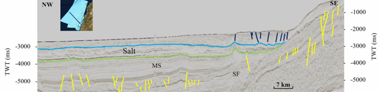 Fig. 12
2D seismic section of the 3D data from the southern margin showing minor faulting in the pre-salt layers (yellow) and post-salt layers (dark blue), with no major thrusting. Seafloor morphology is related to shallow normal and listric faulting in the post-salt layers beyond the slope break. MS merging seam of 3D seismic volumes. SF seismic signal fading that might be due to possible gas chimney. Location in inset and in Fig. 2
Faysal et al. (2023)
- from Faysal et al. (2023)
 Fig. 13
2D seismic section of the 3D data from the southern margin showing the salt layer pinching out and being offset across the Damour fault zone (dashed yellow). Yellow faults originate in the pre-salt layers. Sinistral strike-slip movement is in accordance with onshore tectonics. Dark blue faults affect the post-salt layers. Sharp break in the seafloor above the fault zone suggests active tectonic faulting, while seafloor morphology beyond the slope break is related to shallow normal and listric faulting in the post-salt layers. Transpression is concentrated along the margin. MS merging seam of 3D seismic volumes. Location in inset and in Fig. 2
Faysal et al. (2023)
- from Nemer et al. (2023)
 Fig. 1
- Regional map of the Middle East showing the eastern Mediterranean area and the Arabian, African, and Anatolian plates; dashed box is the location of (b)
- Digital elevation model (Shuttle Radar Topography Mission, 90-m resolution) of the eastern Mediterranean region showing the different segments of the Dead Sea Transform Fault; box shows the location of the Lebanese Restraining Bend (c)
- Digital elevation model (Shuttle Radar Topography Mission, 90-m resolution) of the Lebanese Restraining Bend showing the main units, structures, and places that are referred to throughout the text
- from Nemer et al. (2023)
 Fig. 2
The study area with:
- main faults (red)
- folds (green)
- seismogenic zones (blue outlines, cf. Fig. 4)
- estimated epicentral locations (black squares annotated by date and magnitude) of the major historical earthquakes of the Lebanese Restraining Bend (e.g. Sbeinati et al., 2005)
- instrumental seismicity earthquakes with magnitudes ≥ 4
- from Nemer et al. (2023)

The study area with
- main faults (red)
- folds (green)
- seismogenic zones (blue outlines and labels) associated with their focal mechanism solutions
- after Pondrelli et al. (2002) (light blue), Salamon et al. (2003) (green), Hofstetter et al. (2007) (yellow), Abdul-Wahed et al. (2011) (orange)
- after Meirova and Hofstetter (2013) (pink)
- after Palano et al. (2013) (red)
- from Table 1
- F fault
- Fl flexure
- M middle
- N northern
- S southern
- St structure

 Focal Mechanisms vs. Fault Type
Wikipedia
Mikenorton - CC BY-SA 3.0
 Development of the Focal
Mechanism Beach Ball
Wikipedia
Mikenorton - CC BY-SA 3.0
- from Nemer et al. (2023)
 Fig. 5
- The study area with regional polygons that delimit the velocity structural models (differentiated by colors)
- Geological map of the study area after Dubertret (1962)
- from Nemer et al. (2023)
 Fig. 5b
Geological map of the study area after Dubertret (1962)
Nemer et al. (2023)
- from Nemer et al. (2023)

 Table 2
Velocity parameters (upper 40 km) of the different regional polygons used to define the structural models
Nemer et al. (2023)