Tyre
 Tyre
Tyreclick on image to explore this site on a new tab in Google Earth
| Transliterated Name | Source | Name |
|---|---|---|
| Tyre | Arabic | صور |
| Tyrus | Latin | |
| Tyros | Greek | Τύρος |
| Sur | Phoenician | |
| Ṣurru | Akkadian | |
| Tzór | Hebrew | צוֹר |
- Fig. 2 Location of cores and
coastal bathymetry from Marriner et al (2005)
 Fig. 2
Tyre, location of cores and coastal bathymetry. The strongest winds and swell derive from the south-west. Core sites are marked by a black dot.
Marriner et al (2005) - Fig. 14 Reconstructed palaeobathymetry
of Tyre around 6000 years BP from Marriner et al (2005)
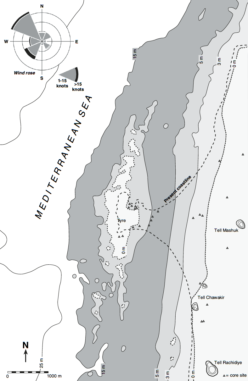 Fig. 14
Reconstructed palaeobathymetry of Tyre around 6000 years BP. Coastline reconstructed using stratigraphy, present bathymetry and geochronology.
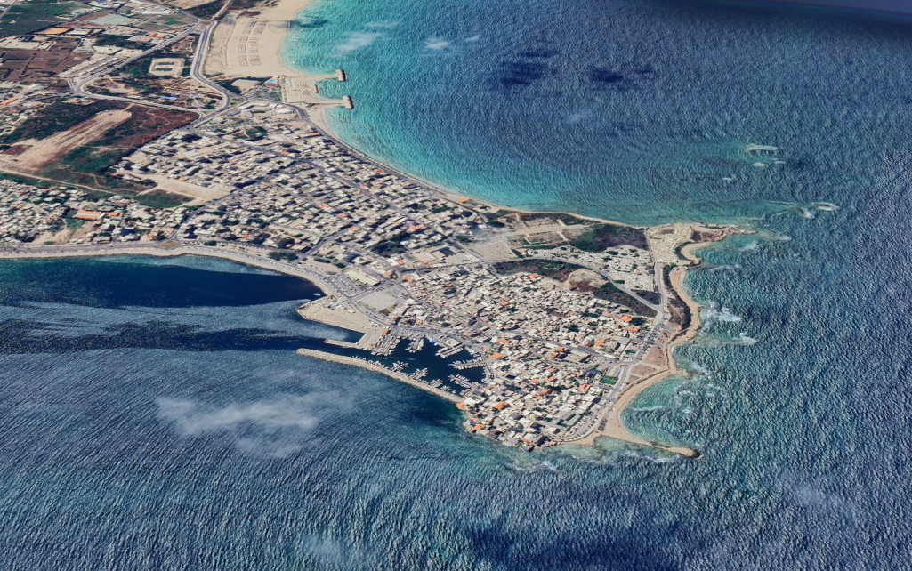
Marriner et al (2005) - Fig. 17 Aerial photograph with
core locations from Marriner et al (2005)
 Fig. 17
Maximum extension of Tyre’s MBA northern harbour (1950s aerial photograph). Our work reveals the ancient harbour was ca. 40% larger than present, the extra surface area lying beneath the Medieval and Modern city centres
Marriner et al (2005) - Tyre in Google Earth
Tyre
click on image to explore this site on a new tab in Google Earth
- Fig. 2 Location of cores and
coastal bathymetry from Marriner et al (2005)
Fig. 2
Tyre, location of cores and coastal bathymetry. The strongest winds and swell derive from the south-west. Core sites are marked by a black dot.
Marriner et al (2005) - Fig. 14 Reconstructed palaeobathymetry
of Tyre around 6000 years BP from Marriner et al (2005)
Fig. 14
Reconstructed palaeobathymetry of Tyre around 6000 years BP. Coastline reconstructed using stratigraphy, present bathymetry and geochronology.
Marriner et al (2005)
- Fig. 1 Site plan from
Gatier et al (2011)
 Fig. 1
General plan of the site
Inventory 2009 (G. Ch., C. D., Cl. P., X. H., Mission de Tyr)
Gatier et al (2011) - Fig. 6 Plan of the thermal
complex and residential area Gatier et al (2011)
 Fig. 6
(G. Ch., C. D., X. H., Mission de Tyr)
Gatier et al (2011)
- Fig. 1 Site plan from
Gatier et al (2011)
Fig. 1
General plan of the site
Inventory 2009 (G. Ch., C. D., Cl. P., X. H., Mission de Tyr)
Gatier et al (2011) - Fig. 6 Plan of the thermal
complex and residential area Gatier et al (2011)
Fig. 6
(G. Ch., C. D., X. H., Mission de Tyr)
Gatier et al (2011)
-
Fig. 3 Macrofauna core TV
from Marriner et al (2005)
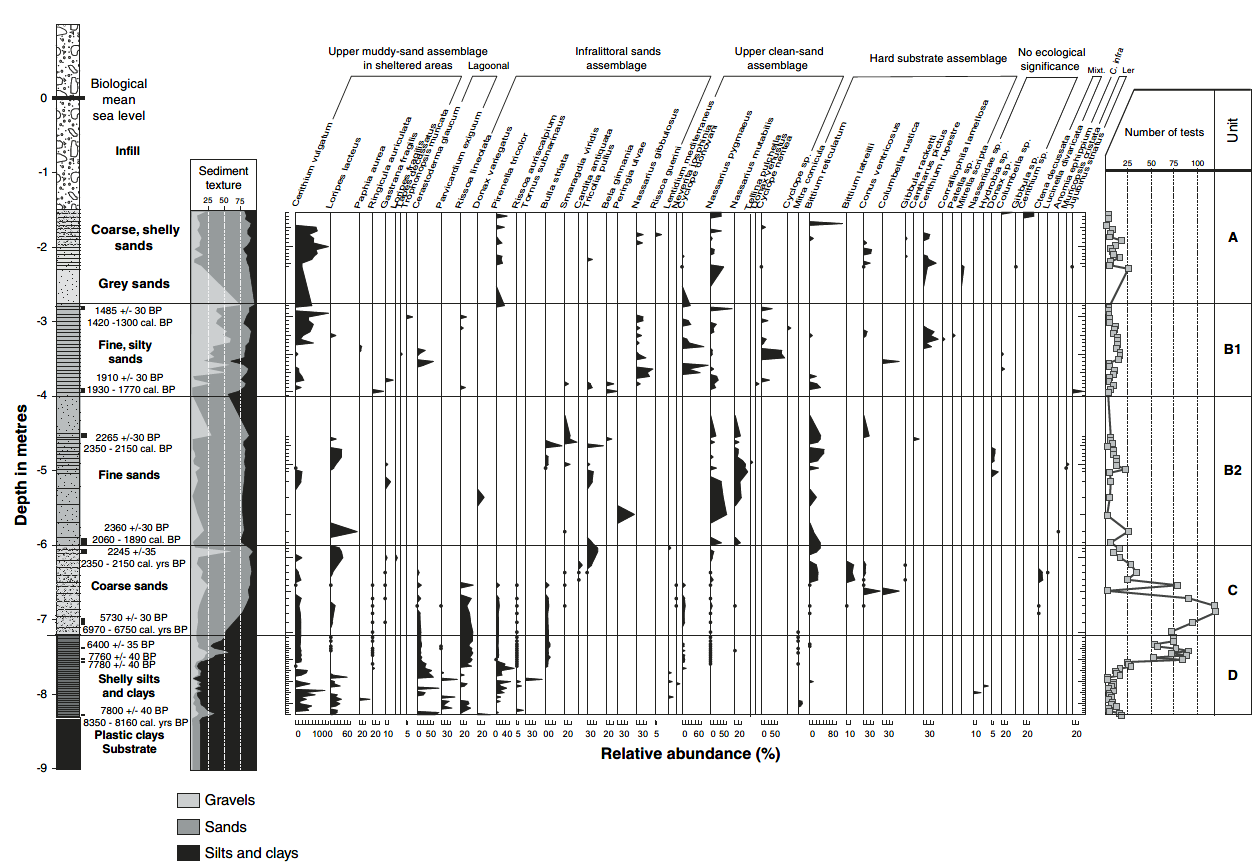 Fig. 3
Macrofauna core TV.
Marriner et al (2005) -
Fig. 4 Ostracoda core TV
from Marriner et al (2005)
 Fig. 4
Ostracoda core TV.
Marriner et al (2005) -
Fig. 8 Grain size analyses
core TIX from Marriner et al (2005)
 Fig. 8
Grain size analyses core TIX.
Marriner et al (2005) -
Fig. 9 Grain size analyses
core TI from Marriner et al (2005)
 Fig. 9
Grain size analyses core TI.
Marriner et al (2005) -
Fig. 10 Macrofauna core
TIX from Marriner et al (2005)
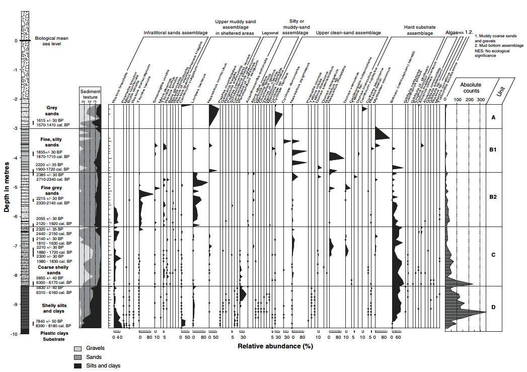 Fig. 10
Macrofauna core TIX.
Marriner et al (2005) -
Fig. 11 Macrofauna core
TI from Marriner et al (2005)
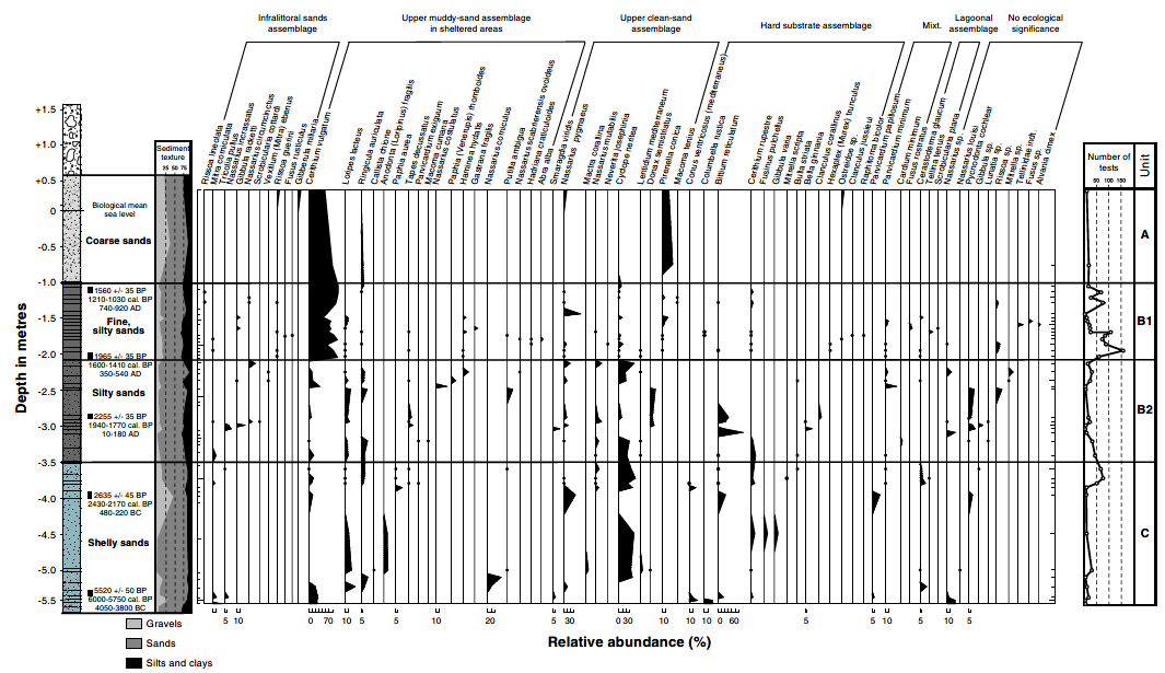 Fig. 11
Macrofauna core TI.
Marriner et al (2005) -
Fig. 12 Ostracoda core TI
from Marriner et al (2005)
 Fig. 12
Ostracoda core TI.
Marriner et al (2005) -
Fig. 13 Foraminifera core
TI from Marriner et al (2005)
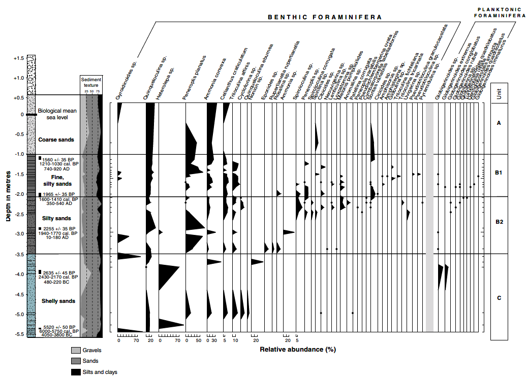 Fig. 13
Foraminifera core TI.
Marriner et al (2005) -
Cross-correlation of stratigraphic
units from cores in the northern harbour from Marriner et al (2005)
 Fig. 16
Cross-correlation of stratigraphic units from cores in the northern harbour.
Marriner et al (2005)
- Earthquake Archeological
Effects from Rodríguez-Pascua et al (2013: 221-224)
 Earthquake Archeological
Effects Chart
Earthquake Archeological
Effects Chart
Click on image to open in a new tab
Rodríguez-Pascua et al (2013)
| Effect | Location | Image(s) | Description | Intensity |
|---|---|---|---|---|
|
Tyre |
|
|
- Earthquake Archeological
Effects from Rodríguez-Pascua et al (2013: 221-224)
Earthquake Archeological
Effects Chart
Click on image to open in a new tab
Rodríguez-Pascua et al (2013)
| Effect | Location | Image(s) | Description | Intensity |
|---|---|---|---|---|
|
Somewhere between Acre and Tyre |
|
|
- Earthquake Archeological
Effects from Rodríguez-Pascua et al (2013: 221-224)
Earthquake Archeological
Effects Chart
Click on image to open in a new tab
Rodríguez-Pascua et al (2013)
| Effect | Location | Image(s) | Description | Intensity |
|---|---|---|---|---|
|
Tyre |
|
|
- Earthquake Archeological
Effects from Rodríguez-Pascua et al (2013: 221-224)
Earthquake Archeological
Effects Chart
Click on image to open in a new tab
Rodríguez-Pascua et al (2013)
| Effect | Location | Image(s) | Description | Intensity |
|---|---|---|---|---|
|
Tyre |
|
|
- Simple MMI Intensity Scale
 Simple MMI Intensity
Scale
Simple MMI Intensity
Scale
Click on image to open in a new tab - More Subjective MMI Intensity Scale
 More Subjective MMI Scale
Click on image to open in a new tab
| Effect | Location | Image(s) | Description | Intensity |
|---|---|---|---|---|
|
Tyre |
|
|
- Simple MMI Intensity Scale
Simple MMI Intensity
Scale
Click on image to open in a new tab - More Subjective MMI Intensity Scale
More Subjective MMI Scale
Click on image to open in a new tab
| Effect | Location | Image(s) | Description | Intensity |
|---|---|---|---|---|
|
Tyre |
|
|
- Earthquake Archeological
Effects from Rodríguez-Pascua et al (2013: 221-224)
Earthquake Archeological
Effects Chart
Click on image to open in a new tab
Rodríguez-Pascua et al (2013)
| Effect | Location | Image(s) | Description | Intensity |
|---|---|---|---|---|
|
Tyre |
|
|
- Earthquake Archeological
Effects from Rodríguez-Pascua et al (2013: 221-224)
Earthquake Archeological
Effects Chart
Click on image to open in a new tab
Rodríguez-Pascua et al (2013)
| Effect | Location | Image(s) | Description | Intensity |
|---|---|---|---|---|
|
Tyre |
|
|
- Earthquake Archeological
Effects from Rodríguez-Pascua et al (2013: 221-224)
Earthquake Archeological
Effects Chart
Click on image to open in a new tab
Rodríguez-Pascua et al (2013)
| Effect | Location | Image(s) | Description | Intensity |
|---|---|---|---|---|
|
Tyre |
|
|
- Earthquake Archeological
Effects from Rodríguez-Pascua et al (2013: 221-224)
Earthquake Archeological
Effects Chart
Click on image to open in a new tab
Rodríguez-Pascua et al (2013)
| Effect | Location | Image(s) | Description | Intensity |
|---|---|---|---|---|
|
Tyre |
|
|