Sidon
 Fig. 3
Sidon and Zire (from [31]). In the foreground, Sidon’s outer harbour lies in the shadow zone of Zire island. The promontory of Sidon separates two coves, the northern harbour and Poidebard’s Crique Ronde.
Marriner et al (2006)
| Transliterated Name | Source | Name |
|---|---|---|
| Sidon | English | |
| Sayda | Arabic | صيدا |
| Saida | Modern Arabic | صيدا |
| Ṣaydūn | Classical Arabic | صَيْدونْ |
| Ṣidon | Syriac | ܨܝܕܘܢ |
| Sidṓn | Greek | Σιδών |
| Sidon | Latin | |
| Colonia Aurelia Pia Sidon | Roman colony | |
| Sagittus | Crusader Latin | |
| Saete, Sayette, or Sagette | Crusader French | |
| Ṣīdūn | Phoenician | |
| Djedouna | Papyrus Anastasi I | |
| Ṣīḏōn | Biblical Hebrew | צִידוֹן |
- Fig. 2 Sidon’s coastal bathymetry
from Marriner et al (2006)
 Fig. 2
Sidon’s coastal bathymetry
Marriner et al (2006)
- Fig. 2 Sidon’s coastal bathymetry
from Marriner et al (2006)
Fig. 2
Sidon’s coastal bathymetry
Marriner et al (2006)
- Fig. 3 Aerial Photograph of
Sidon and Zire from Marriner et al (2006)
Fig. 3
Sidon and Zire (from [31]). In the foreground, Sidon’s outer harbour lies in the shadow zone of Zire island. The promontory of Sidon separates two coves, the northern harbour and Poidebard’s Crique Ronde.
Marriner et al (2006) - Sidon in Google Earth
 Sidon
Sidon
click on image to explore this site on a new tab in Google Earth
- Fig. 3 Aerial Photograph of
Sidon and Zire from Marriner et al (2006)
Fig. 3
Sidon and Zire (from [31]). In the foreground, Sidon’s outer harbour lies in the shadow zone of Zire island. The promontory of Sidon separates two coves, the northern harbour and Poidebard’s Crique Ronde.
Marriner et al (2006) - Sidon in Google Earth
Sidon
click on image to explore this site on a new tab in Google Earth
- Fig. 1 Location of cores
from Marriner et al (2006)
 Fig. 1
Sidon’s ancient harbour areas and location of cores
Marriner et al (2006)
- Fig. 1 Location of cores
from Marriner et al (2006)
Fig. 1
Sidon’s ancient harbour areas and location of cores
Marriner et al (2006)
- Fig. 1.3 Plan of
the inner harbour at Sidon from Raban et al. (2009)
 Figure 1.3
Plan of the inner harbour at Sidon
(after Poidebard & Lauffary 1951)
Raban et al. (2009)
- Fig. 1.3 Plan of
the inner harbour at Sidon from Raban et al. (2009)
Figure 1.3
Plan of the inner harbour at Sidon
(after Poidebard & Lauffary 1951)
Raban et al. (2009)
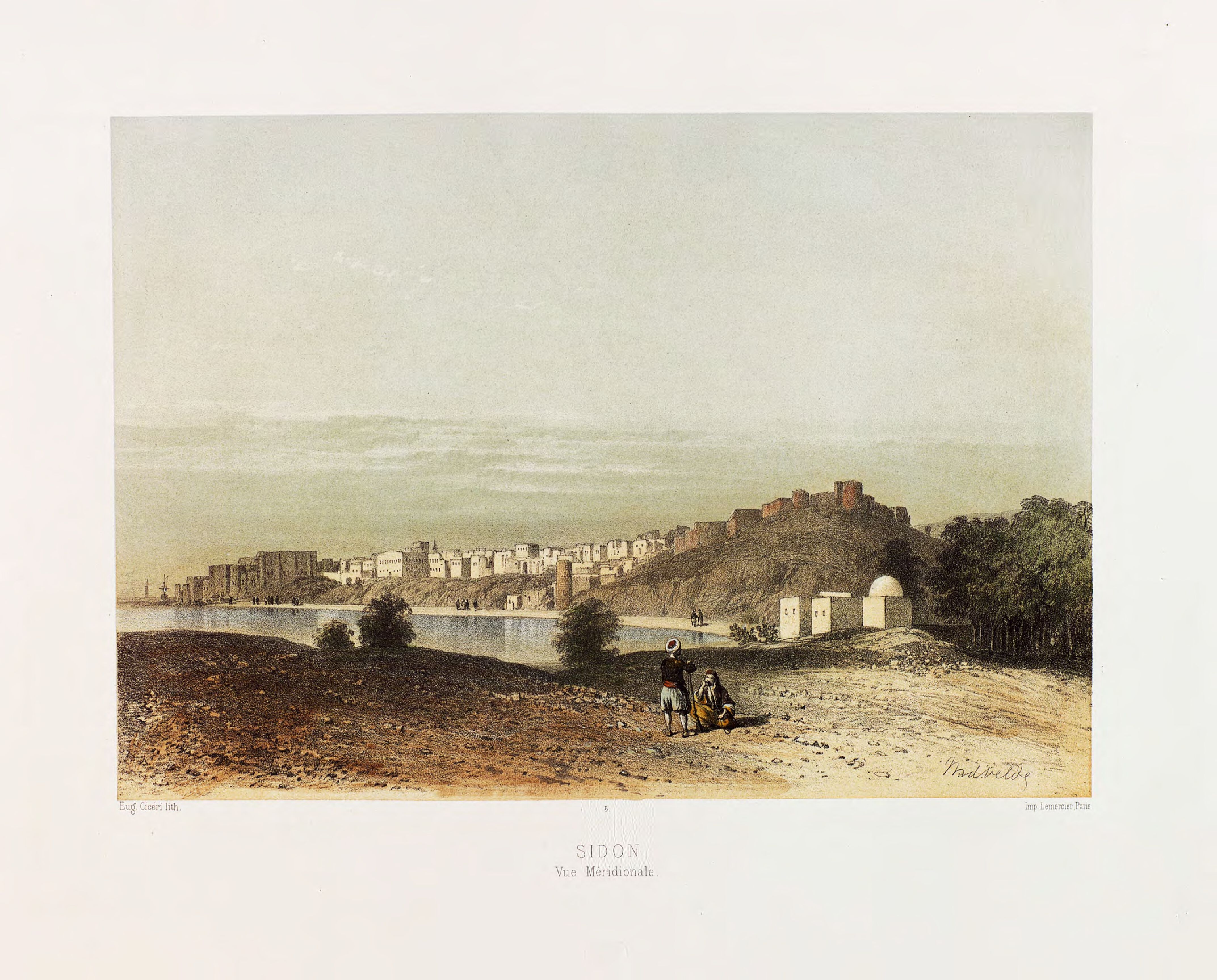
- Painting of Sidon from 1857
 Painting of Sidon from 1857 by C.M.W. van de Velde
click on image to examine a high res magnifiable version in a new tab
Charles William Meredith van de Velde's in Le Pays d'Israel - Public Domian from Wikipedia
- Painting of Sidon from 1857
Painting of Sidon from 1857 by C.M.W. van de Velde
click on image to examine a high res magnifiable version in a new tab
Charles William Meredith van de Velde's in Le Pays d'Israel - Public Domian from Wikipedia
-
Fig. 4 Sedimentology of core BH I
(northern harbour) from Marriner et al (2006)
 Fig. 4
Sedimentology of core BH I (northern harbour).
Marriner et al (2006) -
Fig. 5 Molluscan macrofauna from
core BH I (northern harbour) from Marriner et al (2006)
 Fig. 5
Molluscan macrofauna from core BH I (northern harbour).
Marriner et al (2006) -
Fig. 6 Ostracod microfauna
from core BH I (northern harbour) from Marriner et al (2006)
 Fig. 6
Ostracod microfauna from core BH I (northern harbour)
Marriner et al (2006) -
Fig. 7 Sedimentology of core
BH IX (northern harbour) from Marriner et al (2006)
 Fig. 7
Sedimentology of core BH IX (northern harbour).
Marriner et al (2006) -
Fig. 8 Molluscan macrofauna
from core BH IX (northern harbour) from Marriner et al (2006)
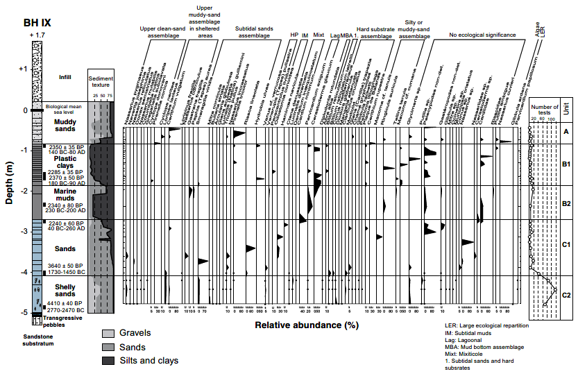 Fig. 8
Molluscan macrofauna from core BH IX (northern harbour).
Marriner et al (2006) -
Fig. 9 Ostracod microfauna
from core BH IX (northern harbour) from Marriner et al (2006)
 Fig. 9
Ostracod microfauna from core BH IX (northern harbour).
Marriner et al (2006) -
Fig. 10 Sedimentology of
core BH XV (northern harbour) from Marriner et al (2006)
 Fig. 10
Sedimentology of core BH XV (northern harbour).
Marriner et al (2006) -
Fig. 11 Molluscan macrofauna from
core BH XV (northern harbour) from Marriner et al (2006)
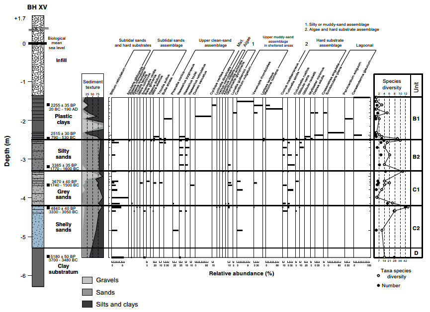 Fig. 11
Molluscan macrofauna from core BH XV (northern harbour).
Marriner et al (2006)
- Earthquake Archeological
Effects from Rodríguez-Pascua et al (2013: 221-224)
 Earthquake Archeological
Effects Chart
Earthquake Archeological
Effects Chart
Click on image to open in a new tab
Rodríguez-Pascua et al (2013)
| Effect | Location | Image(s) | Description | Intensity |
|---|---|---|---|---|
|
Sidon |
|
|
- Earthquake Archeological
Effects from Rodríguez-Pascua et al (2013: 221-224)
Earthquake Archeological
Effects Chart
Click on image to open in a new tab
Rodríguez-Pascua et al (2013)
| Effect | Location | Image(s) | Description | Intensity |
|---|---|---|---|---|
|
Sidon |
|
|
- Earthquake Archeological
Effects from Rodríguez-Pascua et al (2013: 221-224)
Earthquake Archeological
Effects Chart
Click on image to open in a new tab
Rodríguez-Pascua et al (2013)
| Effect | Location | Image(s) | Description | Intensity |
|---|---|---|---|---|
|
Sidon |
|
|
- Earthquake Archeological
Effects from Rodríguez-Pascua et al (2013: 221-224)
Earthquake Archeological
Effects Chart
Click on image to open in a new tab
Rodríguez-Pascua et al (2013) - Simple MMI Intensity Scale
 Simple MMI Intensity
Scale
Simple MMI Intensity
Scale
Click on image to open in a new tab - More Subjective MMI Intensity Scale
 More Subjective MMI Scale
Click on image to open in a new tab
| Effect | Location | Image(s) | Description | Intensity |
|---|---|---|---|---|
|
Sidon |
|
|
- Earthquake Archeological
Effects from Rodríguez-Pascua et al (2013: 221-224)
Earthquake Archeological
Effects Chart
Click on image to open in a new tab
Rodríguez-Pascua et al (2013)
| Effect | Location | Image(s) | Description | Intensity |
|---|---|---|---|---|
|
Sidon |
|
|
- Earthquake Archeological
Effects from Rodríguez-Pascua et al (2013: 221-224)
Earthquake Archeological
Effects Chart
Click on image to open in a new tab
Rodríguez-Pascua et al (2013)
| Effect | Location | Image(s) | Description(s) | Intensity |
|---|---|---|---|---|
|
Sidon |
|
|
- Earthquake Archeological
Effects from Rodríguez-Pascua et al (2013: 221-224)
Earthquake Archeological
Effects Chart
Click on image to open in a new tab
Rodríguez-Pascua et al (2013)
| Effect | Location | Image(s) | Description(s) | Intensity |
|---|---|---|---|---|
|
Sidon |
|
|