el-Lejjun (aka Betthorus)
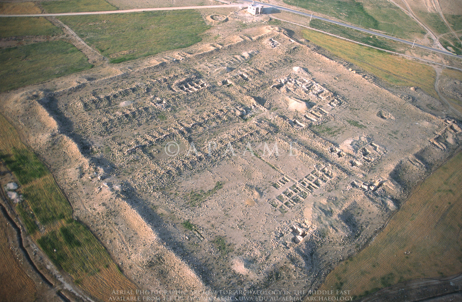
APAAME
- Reference: APAAME_20070419_DLK-0009
- Photographer: David Leslie Kennedy
- Credit: Aerial Photographic Archive for Archaeology in the Middle East
- Copyright: Creative Commons Attribution-Noncommercial-No Derivative Works
Click photo for high res magnifiable image
| Transliterated Name | Language | Name |
|---|---|---|
| el-Lejjun | Arabic | يل ليججون |
| Legio | Latin | |
| Betthorus | Greek ? | Bετθορuσ |
| Baetarus |
- Map of Limes Arabicus
Fortresses in Jordan from Wikipedia
 Limes arabicus, central part in Jordan - Azraq basin and Wadi el-Mujib basin. Red squares are
Roman fortresses and forts from the end of the 3rd/beginning of the 4th century.
Limes arabicus, central part in Jordan - Azraq basin and Wadi el-Mujib basin. Red squares are
Roman fortresses and forts from the end of the 3rd/beginning of the 4th century.
(modified from S. T. Parker, An Empire's New Holy Land: The Byzantine Perio, Near Eastern Archaeology , Sep., 1999, Vol. 62, No. 3 (Sep., 1999), p. 138)
Ursus - Wikipedia - CC-BY-SA 4.0 - Location Map from
Stern et al (1993 v. 3)
 El-Lejjun: map of the site and its surroundings
Stern et al (1993 v. 3) - Aerial view of El-Lejjun
from APAAME
Aerial view of El-Lejjun
APAAME
- Reference: APAAME_20070419_DLK-0009
- Photographer: David Leslie Kennedy
- Credit: Aerial Photographic Archive for Archaeology in the Middle East
- Copyright: Creative Commons Attribution-Noncommercial-No Derivative Works
- El-Lejjun in Google Earth
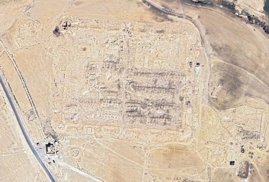 El-Lejjun
click on image to explore this site on a new tab in Google Earth - Aerial Photo El-Lejjun
and environs from Parker et al (2006)
 Pl 3.1
Aerial photo (1982) of el-Lejjun:
- Roman fortress
- Early Bronze (EB) Age site
- 'Ain Lejjun (spring)
- Khirbet el-Fityan
- Ottoman barracks
(Royal Geographic Centre of Jordan
Parker et al (2006)
- Plan of the Fort at El-Lejjun
modified from Parker et al (2006)
 Plan of el-Lejjun fortress with excavation areas
1980-89
modified by JW from Parker et al (2006) - Plan of the Fort at El-Lejjun
modified (?) from Parker et al (2006) - oriented to match with the APAAME photo
 Plan of el-Lejjun fortress
Mike Bishop flickr modified (?) from Parker et al (2006) - Fig. I Plan of the Fort at
El-Lejjun from Meyers et al (1997)
 Figure I
Plan of el-Lejjun (ancient Betthorus). A later Roman legionary fortress east of the Dead Sea. Built around 300 CE for legio IV Martia
(Courtesy S. T. Parker)
Meyers et al (1997) - Illustrated reconstruction of
El-Lejjun from Campbell (2006)
 Fig. 6
Reconstruction of El-Lejjun
Campbell (2006:59)
- Plan of the Fort at El-Lejjun
modified from Parker et al (2006)
Plan of el-Lejjun fortress with excavation areas
1980-89
modified by JW from Parker et al (2006) - Fig. I Plan of the Fort at
El-Lejjun from Meyers et al (1997)
Figure I
Plan of el-Lejjun (ancient Betthorus). A later Roman legionary fortress east of the Dead Sea. Built around 300 CE for legio IV Martia
(Courtesy S. T. Parker)
Meyers et al (1997)
- Plan of the principia
(headquarters building) in the Early Byzantine period from Stern et al (1993 v. 3)
 Plan of the principia (headquarters building) in the Early Byzantine period
Stern et al (1993 v. 3) - Fig. 4.1 Plan of the principia
(headquarters building) in the Early Byzantine period from Parker et al (2006)
 Fig. 4.1
Plan of the principia in the Early Byzantine period (Strata VA-IV) with excavation squares
Parker et al (2006) - Fig. 4.2 Plan of the
three rooms of the northern range of the principia from Parker et al (2006)
 Fig. 4.2
Plan of the three rooms of the northern range of the principia, with excavation squares (A.12-14)
Parker et al (2006) - Fig. 4.5A Axonometric view
of the southwest corner of the principia from Parker et al (2006)
 Fig. 4.5A
Axonometric view of the southwest corner of the principia, showing the cross hall, southern entrance, southern tribunal, aedes, southern passageway, and southern room of the official block
Parker et al (2006) - Fig. 4.5B Perspective view
of the arcaded portico, southern entrance, and southern tribunal of principia from Parker et al (2006)
 Fig. 4.5B
Perspective view of the arcaded portico, southern entrance, and southern tribunal of principia
Parker et al (2006) - Fig. 4.6A Axonometric view
of the southern half of the aedes from Parker et al (2006)
 Fig. 4.6A
Axonometric view of the southern half of the aedes, showing the steps up to the elevated platform and to the base for the legionary stnadrad in the apsidal niche against the rear wall
Parker et al (2006) - Fig. 4.6C Section view
of the barrel vaults along the south wall of the aedes from Parker et al (2006)
 Fig. 4.6C
Elevation of the barrel vaults along the south wall of the aedes, looking south
Parker et al (2006)
- Fig. 4.1 Plan of the principia
(headquarters building) in the Early Byzantine period from Parker et al (2006)
Fig. 4.1
Plan of the principia in the Early Byzantine period (Strata VA-IV) with excavation squares
Parker et al (2006) - Fig. 4.2 Plan of the
three rooms of the northern range of the principia from Parker et al (2006)
Fig. 4.2
Plan of the three rooms of the northern range of the principia, with excavation squares (A.12-14)
Parker et al (2006) - Fig. 4.6C Section view
of the barrel vaults along the south wall of the aedes from Parker et al (2006)
Fig. 4.6C
Elevation of the barrel vaults along the south wall of the aedes, looking south
Parker et al (2006)
- Fig. 4.3 Plan of the
western end of the via praetoria at its intersection with the groma from Parker et al (2006)
 Fig. 4.3
Plan of the western end of the via praetoria at its intersection with the groma
Parker et al (2006) - Fig. 4.4 Section through
the south doorways of the groma from Parker et al (2006)
 Fig. 4.4
Section through the south doorways of the groma, looking south
Parker et al (2006)
- Fig. 4.3 Plan of the
western end of the via praetoria at its intersection with the groma from Parker et al (2006)
Fig. 4.3
Plan of the western end of the via praetoria at its intersection with the groma
Parker et al (2006) - Fig. 4.4 Section through
the south doorways of the groma from Parker et al (2006)
Fig. 4.4
Section through the south doorways of the groma, looking south
Parker et al (2006)
- Fig. 5.1 Plan of the
early Byzantine barracks (Area B) from Parker et al (2006)
 Fig. 5.1
Plan of Area B: the Early Byzantine Barracks (Strata VA-IV)
Parker et al (2006) - Fig. 5.2 Plan of the
early Late Roman Barracks (Area B) from Parker et al (2006)
 Fig. 5.2
Plan of Area B: the Late Roman Barracks (Stratum VI)
Parker et al (2006) - Plan of the barracks
from ACOR website
 Jordan. El-Lejjun, plan of Byzantine barracks
ACOR website
- Fig. 5.1 Plan of the
early Byzantine barracks (Area B) from Parker et al (2006)
Fig. 5.1
Plan of Area B: the Early Byzantine Barracks (Strata VA-IV)
Parker et al (2006) - Fig. 5.2 Plan of the
early Late Roman Barracks (Area B) from Parker et al (2006)
Fig. 5.2
Plan of Area B: the Late Roman Barracks (Stratum VI)
Parker et al (2006)
- Fig. 6.8 Plan of the north gate
from Parker et al (2006)
 Fig. 6.8
Plan of the north gate (porta principalis sinistra) of the el-Lejjun fortress
Parker et al (2006) - Plan of the north gate
from Wikipedia (Mediatus)
 Plan of the Porta Principalis sinistra after partial excavation by the Limes Arabicus project
Betthorus legionary camp - excavation plan of the Porta principalis sinistra , Limes Arabicus Project, Jordan.
Click on photo to open a high resolution magnifiable image in a new tab
Mediatus - Wikipedia - CC BY-SA 3.0 - Fig. 6.9 Partially
reconstructed north facade of the north gate from Parker et al (2006)
 Fig. 6.9
Partially reconstructed north facade of the north gate
Parker et al (2006) - Fig. 6.10 The rampart
stairway of the northern gate from Parker et al (2006)
 Fig. 6.10
The rampart stairway of the northern gate
Parker et al (2006) - Fig. 6.11 Perspective
of the north gate at eye level of an approaching rider from Parker et al (2006)
 Fig. 6.11
Perspective of the north gate at eye level of an approaching rider
Parker et al (2006) - Fig. 6.12 Plan of
Late Byzantine domestic complex near the north gate from Parker et al (2006)
 Fig. 6.12
Plan of Late Byzantine domestic complex near the north gate
Parker et al (2006) - Fig. 6.2 Reconstruction
of the juncture of the interval tower and curtain wall from Parker et al (2006)
 Fig. 6.2
Reconstruction of the juncture of the interval tower and curtain wall
Parker et al (2006)
- Fig. 6.8 Plan of the north gate
from Parker et al (2006)
Fig. 6.8
Plan of the north gate (porta principalis sinistra) of the el-Lejjun fortress
Parker et al (2006) - Plan of the north gate
from Wikipedia (Mediatus)
Plan of the Porta Principalis sinistra after partial excavation by the Limes Arabicus project
Betthorus legionary camp - excavation plan of the Porta principalis sinistra , Limes Arabicus Project, Jordan.
Click on photo to open a high resolution magnifiable image in a new tab
Mediatus - Wikipedia - CC BY-SA 3.0 - Fig. 6.9 Partially
reconstructed north facade of the north gate from Parker et al (2006)
Fig. 6.9
Partially reconstructed north facade of the north gate
Parker et al (2006) - Fig. 6.10 The rampart
stairway of the northern gate from Parker et al (2006)
Fig. 6.10
The rampart stairway of the northern gate
Parker et al (2006) - Fig. 6.11 Perspective
of the north gate at eye level of an approaching rider from Parker et al (2006)
Fig. 6.11
Perspective of the north gate at eye level of an approaching rider
Parker et al (2006) - Fig. 6.12 Plan of
Late Byzantine domestic complex near the north gate from Parker et al (2006)
Fig. 6.12
Plan of Late Byzantine domestic complex near the north gate
Parker et al (2006) - Fig. 6.2 Reconstruction
of the juncture of the interval tower and curtain wall from Parker et al (2006)
Fig. 6.2
Reconstruction of the juncture of the interval tower and curtain wall
Parker et al (2006)
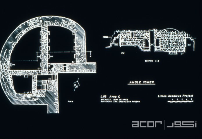
- Fig. 6.3 Plan and section
of the northwest angle tower of the el-Lejjun fortress from Parker et al (2006)
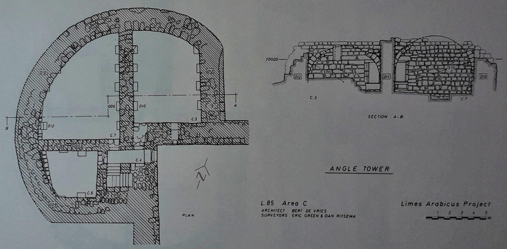 Fig. 6.3
Plan and section of the northwest angle tower of the el-Lejjun fortress
Parker et al (2006) - Fig. 6.4 Plan and section
of the interval tower of the el-Lejjun fortress from Parker et al (2006)
 Fig. 6.4
Plan and section of the interval tower of the el-Lejjun fortress
Parker et al (2006) - Fig. 6.5 Schematic section
of loci in C.6, southwest room of the northwest angle tower of the el-Lejjun fortress from Parker et al (2006)
 Fig. 6.5
Schematic section of loci in C.6, southwest room of the northwest angle tower of the el-Lejjun fortress
Parker et al (2006) - Fig. 6.6 Plans
and sections of the northwest angle tower stairway from Parker et al (2006)
 Fig. 6.6
Plans and sections of the northwest angle tower stairway
Parker et al (2006) - Fig. 6.7 Restored section C-D
showing the angle tower from Parker et al (2006)
 Fig. 6.7
Restored section C-D (see Fig. 6.6) showing the angle tower with either two or three floors
Parker et al (2006) - Plan of the NW tower
from ACOR website
 Jordan. El-Lejjun, plan of north west tower
ACOR website
- Fig. 6.3 Plan and section
of the northwest angle tower of the el-Lejjun fortress from Parker et al (2006)
Fig. 6.3
Plan and section of the northwest angle tower of the el-Lejjun fortress
Parker et al (2006) - Fig. 6.4 Plan and section
of the interval tower of the el-Lejjun fortress from Parker et al (2006)
Fig. 6.4
Plan and section of the interval tower of the el-Lejjun fortress
Parker et al (2006) - Fig. 6.5 Schematic section
of loci in C.6, southwest room of the northwest angle tower of the el-Lejjun fortress from Parker et al (2006)
Fig. 6.5
Schematic section of loci in C.6, southwest room of the northwest angle tower of the el-Lejjun fortress
Parker et al (2006) - Fig. 6.6 Plans
and sections of the northwest angle tower stairway from Parker et al (2006)
Fig. 6.6
Plans and sections of the northwest angle tower stairway
Parker et al (2006) - Fig. 6.7 Restored section C-D
showing the angle tower from Parker et al (2006)
Fig. 6.7
Restored section C-D (see Fig. 6.6) showing the angle tower with either two or three floors
Parker et al (2006) - Plan of the NW tower
from ACOR website
Jordan. El-Lejjun, plan of north west tower
ACOR website
- Plan of north part of the fort
from Wikipedia (Mediatus)
 The north-western area of the legionary camp with the porta principalis sinistra ,
the military baths, the cistern and accommodation buildings. Only the older, late Roman
expansion phase is taken into account in the figure
The north-western area of the legionary camp with the porta principalis sinistra ,
the military baths, the cistern and accommodation buildings. Only the older, late Roman
expansion phase is taken into account in the figure
Legion camp Betthorus - Plan of the excavations, Limes Arabicus Project, Jordan. Only the late Roman expansion phase is taken into account.
Click on photo to open a high resolution magnifiable image in a new tab
Mediatus - Wikipedia - CC BY-SA 3.0 - Fig. 6.2 Reconstruction
of the juncture of the interval tower and curtain wall from Parker et al (2006)
Fig. 6.2
Reconstruction of the juncture of the interval tower and curtain wall
Parker et al (2006)
- Plan of north part of the fort
from Wikipedia (Mediatus)
The north-western area of the legionary camp with the porta principalis sinistra ,
the military baths, the cistern and accommodation buildings. Only the older, late Roman
expansion phase is taken into account in the figure
Legion camp Betthorus - Plan of the excavations, Limes Arabicus Project, Jordan. Only the late Roman expansion phase is taken into account.
Click on photo to open a high resolution magnifiable image in a new tab
Mediatus - Wikipedia - CC BY-SA 3.0 - Fig. 6.2 Reconstruction
of the juncture of the interval tower and curtain wall from Parker et al (2006)
Fig. 6.2
Reconstruction of the juncture of the interval tower and curtain wall
Parker et al (2006)
- Plan of a structure
in the vicus from Stern et al (1993 v. 3)
 El-Lejjun: plan of a structure in the vicus (civilian settlement)
Stern et al (1993 v. 3)
- Plan of the bath
from ACOR website
 Jordan. El-Lejjun, plan of bath
ACOR website - Plan of the bath
from wikipedia
 Betthorus Legion Camp - Plan of the military baths, Limes Arabicus Project, Jordan
click on image to open a high res magnifiable version in a new tab
(source: Samuel Thomas Parker: The Roman Frontier in central Jordan. Final Report on the Limes Arabicus Project 1980-1989. Volume 1, (= Dumbarton Oaks studies 40), Fig. 7.1.)
Mediatus - Wikipedia - CC-BY-SA-3.0 & GFDL

- Plan of the bath
from ACOR website
Jordan. El-Lejjun, plan of bath
ACOR website - Plan of the bath
from wikipedia
Betthorus Legion Camp - Plan of the military baths, Limes Arabicus Project, Jordan
click on image to open a high res magnifiable version in a new tab
(source: Samuel Thomas Parker: The Roman Frontier in central Jordan. Final Report on the Limes Arabicus Project 1980-1989. Volume 1, (= Dumbarton Oaks studies 40), Fig. 7.1.)
Mediatus - Wikipedia - CC-BY-SA-3.0 & GFDL
- Fig. 8.1 Plan of
Area N showing three excavated rooms (N.1-3) from Parker et al (2006)
 Fig. 8.1
Plan of Area N showing three excavated rooms (N.1-3)
Parker et al (2006) - Fig. 8.2 Balk
sections in room N.2 from Parker et al (2006)
 Fig. 8.2
Balk sections in room N.2
Parker et al (2006) - Fig. 8.3 West
section of southwest corner balk of room N.3 from Parker et al (2006)
 Fig. 8.3
West section of southwest corner balk of room N.3
Parker et al (2006)
- Fig. 8.1 Plan of
Area N showing three excavated rooms (N.1-3) from Parker et al (2006)
Fig. 8.1
Plan of Area N showing three excavated rooms (N.1-3)
Parker et al (2006) - Fig. 8.2 Balk
sections in room N.2 from Parker et al (2006)
Fig. 8.2
Balk sections in room N.2
Parker et al (2006) - Fig. 8.3 West
section of southwest corner balk of room N.3 from Parker et al (2006)
Fig. 8.3
West section of southwest corner balk of room N.3
Parker et al (2006)
- Fig. 4.13 Fallen arch
from Parker et al (2006)
 Fig. 4.13
Entrance blocked by fallen arch into room A.12 in the northern range of the principia. The vertical meter stick rests in the southwest corner of the room. View to the south
Parker et al (2006) - Plate 6.1 northeast room
(C.3) within the angle tower with lower layer of tumble from Parker et al (2006)
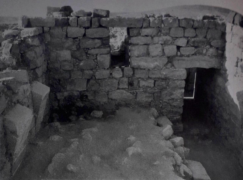 Plate 6.1
The northeast room (C.3) within the angle tower. The two meter sticks rest in the window. Note the arch springers in the walls to the left and right. In the foreground is the lower layer of tumble within the room. View to south.
Parker et al (2006) - Plate 12.3 Collapsed arch
and roof corbels (in situ) in southeast room (Q7) of the Vicus Temple from Parker et al (2006)
 Plate 12.3
Collapsed arch and roof corbels in situ in southeast room (Q7) of arcade [of the Vicus Temple]. View to the east
Parker et al (2006) - Collapsed Wall in Principia
- photo by JW
 Uniformly collapsed wall - looking west - wall fell towards to south
Click on image to open in a new tab
Photo by Jefferson Williams - 2 Feb. 2026 - Tilted Wall in Principia
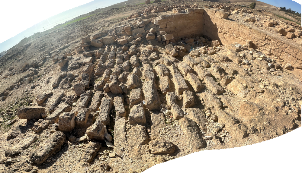
- digital theodolite photo by JW
 Tilted Wall in Principia
Click on image to open in a new tab
digital theodolite photo by Jefferson Williams - 30 Jan. 2026 - Tilted Wall in Principia
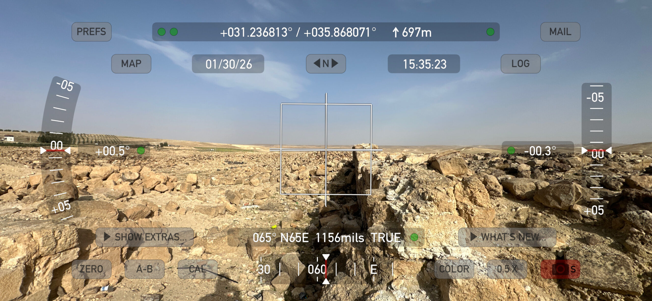
- Tilt Measurement of ~4.5 degrees - digital theodolite photo by JW
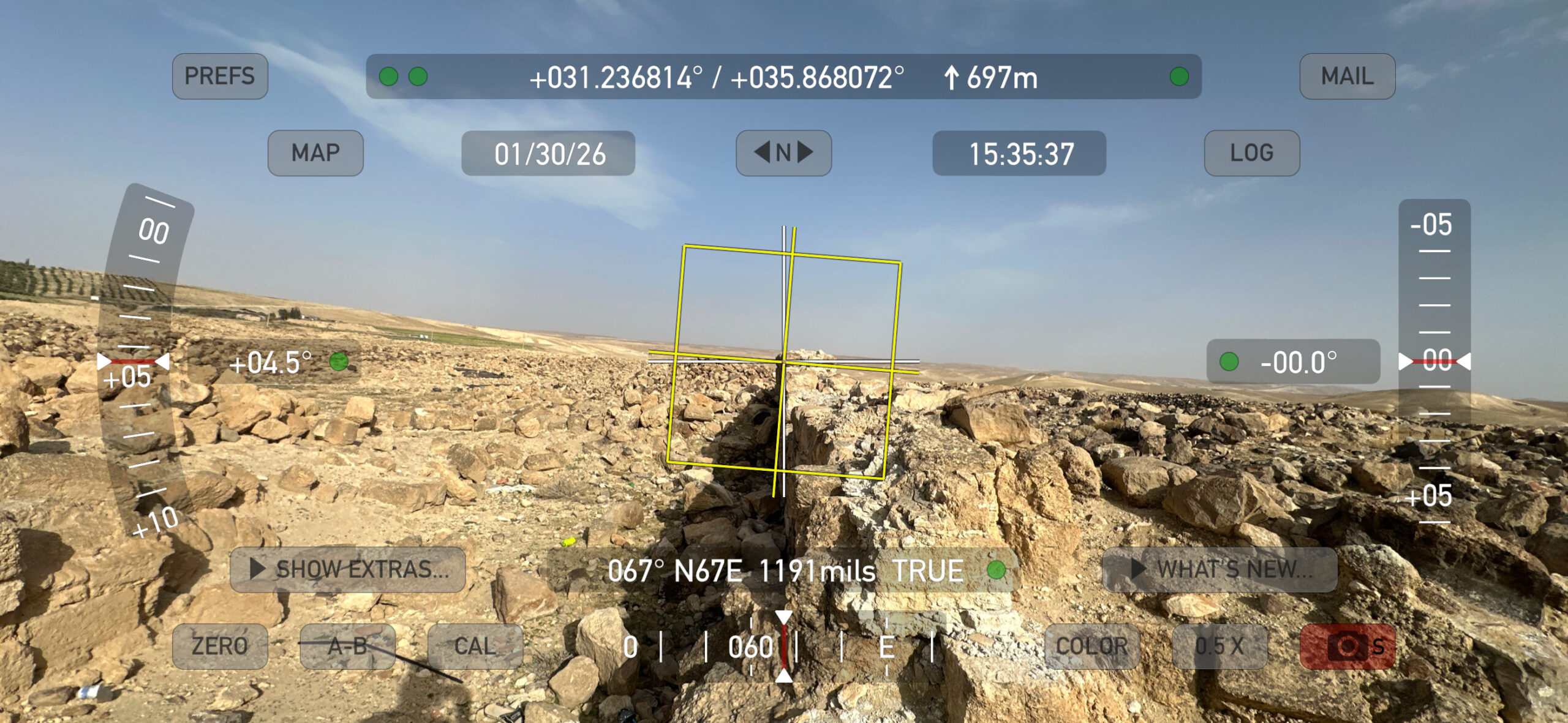 Tilted Wall in Principia. Tilt Measurement of ~4.5 degrees
Click on image to open in a new tab
digital theodolite photo by Jefferson Williams - 30 Jan. 2026
- Fig. 4.13 Fallen arch
from Parker et al (2006)
Fig. 4.13
Entrance blocked by fallen arch into room A.12 in the northern range of the principia. The vertical meter stick rests in the southwest corner of the room. View to the south
Parker et al (2006) - Plate 6.1 northeast room
(C.3) within the angle tower with lower layer of tumble from Parker et al (2006)
Plate 6.1
The northeast room (C.3) within the angle tower. The two meter sticks rest in the window. Note the arch springers in the walls to the left and right. In the foreground is the lower layer of tumble within the room. View to south.
Parker et al (2006) - Plate 12.3 Collapsed arch
and roof corbels (in situ) in southeast room (Q7) of the Vicus Temple from Parker et al (2006)
Plate 12.3
Collapsed arch and roof corbels in situ in southeast room (Q7) of arcade [of the Vicus Temple]. View to the east
Parker et al (2006) - Collapsed Wall in Principia
- photo by JW
Uniformly collapsed wall - looking west - wall fell towards to south
Click on image to open in a new tab
Photo by Jefferson Williams - 2 Feb. 2026 - Tilted Wall in Principia
- digital theodolite photo by JW
Tilted Wall in Principia
Click on image to open in a new tab
digital theodolite photo by Jefferson Williams - 30 Jan. 2026 - Tilted Wall in Principia
- Tilt Measurement of ~4.5 degrees - digital theodolite photo by JW
Tilted Wall in Principia. Tilt Measurement of ~4.5 degrees
Click on image to open in a new tab
digital theodolite photo by Jefferson Williams - 30 Jan. 2026
- Plan of the Fort at El-Lejjun
modified from Parker et al (2006)
Plan of el-Lejjun fortress with excavation areas
1980-89
modified by JW from Parker et al (2006) - Fig. I Plan of the Fort at
El-Lejjun from Meyers et al (1997)
Figure I
Plan of el-Lejjun (ancient Betthorus). A later Roman legionary fortress east of the Dead Sea. Built around 300 CE for legio IV Martia
(Courtesy S. T. Parker)
Meyers et al (1997)
| Effect | Location | Image(s) | Description |
|---|---|---|---|
| Roof collapse | Room A.13
Plan of the principia (headquarters building) in the Early Byzantine period Stern et al (1993 v. 3)
Plan of el-Lejjun fortress with excavation areas1980-89 modified by JW from Parker et al (2006)
Figure IPlan of el-Lejjun (ancient Betthorus). A later Roman legionary fortress east of the Dead Sea. Built around 300 CE for legio IV Martia (Courtesy S. T. Parker) Meyers et al (1997) |
Lain and Parker (2006:144) report that a beaten earth floor and ash layer in Room A.13 which ante-dated the
1st earthquake (Stratum VI-VB) was chock-full of tile fragmentssuggesting an apparent roof collapse due to an unknown cause. Such "collapse" debris was not found in any other excavation areas. |
| Effect | Location | Image(s) | Description |
|---|---|---|---|
| Collapsed walls |
praetentura
Fig. 5.1 Plan of Area B: the Early Byzantine Barracks (Strata VA-IV) Parker et al (2006)
Plan of el-Lejjun fortress with excavation areas1980-89 modified by JW from Parker et al (2006)
Figure IPlan of el-Lejjun (ancient Betthorus). A later Roman legionary fortress east of the Dead Sea. Built around 300 CE for legio IV Martia (Courtesy S. T. Parker) Meyers et al (1997) |
The original limestone barracks in praetentura and possibly elsewhere in the fortress were leveled to their foundations. New chert barracks, only about half their former number, were erected along a slightly different alignment in both the praetentura and in the latera praetoria south of the principia. Rows of barrack-like rooms were erected on either side of the northern via principalis.- Parker (2006:120) |
|
| Collapsed walls | principia
Plan of the principia (headquarters building) in the Early Byzantine period Stern et al (1993 v. 3)
Plan of el-Lejjun fortress with excavation areas1980-89 modified by JW from Parker et al (2006)
Figure IPlan of el-Lejjun (ancient Betthorus). A later Roman legionary fortress east of the Dead Sea. Built around 300 CE for legio IV Martia (Courtesy S. T. Parker) Meyers et al (1997) |
The principia also seems to have suffered extensive damage, requiring some portions to be completely rebuilt, such as the interior of the aedes, the rooms in the official block north of the aedes, and the rooms north of the central courtyard [of the principia].- Parker (2006:120) |
|
| Collapsed walls | The mansio in the western
vicus
El-Lejjun: plan of a structure in the vicus (civilian settlement) Stern et al (1993 v. 3)
Plan of el-Lejjun fortress with excavation areas1980-89 modified by JW from Parker et al (2006)
Figure IPlan of el-Lejjun (ancient Betthorus). A later Roman legionary fortress east of the Dead Sea. Built around 300 CE for legio IV Martia (Courtesy S. T. Parker) Meyers et al (1997) |
The mansio in the western vicus was destroyed in 363 and never rebuilt.- Parker (2006:120) |
|
| Roof collapse | principia
Plan of the principia (headquarters building) in the Early Byzantine period Stern et al (1993 v. 3)
Plan of el-Lejjun fortress with excavation areas1980-89 modified by JW from Parker et al (2006)
Figure IPlan of el-Lejjun (ancient Betthorus). A later Roman legionary fortress east of the Dead Sea. Built around 300 CE for legio IV Martia (Courtesy S. T. Parker) Meyers et al (1997) |
The earthquake brought down tile roofs throughout the principia- Lain and Parker (2006:131) |
|
| Arch collapse | principia
Plan of the principia (headquarters building) in the Early Byzantine period Stern et al (1993 v. 3)
Plan of el-Lejjun fortress with excavation areas1980-89 modified by JW from Parker et al (2006)
Figure IPlan of el-Lejjun (ancient Betthorus). A later Roman legionary fortress east of the Dead Sea. Built around 300 CE for legio IV Martia (Courtesy S. T. Parker) Meyers et al (1997) |
The west arcade between the central courtyard and the cross hall of the principia fell while the major walls were left standing.- Lain and Parker (2006:131) |
|
| Fallen columns | A.7
Plan of el-Lejjun fortress with excavation areas 1980-89 modified by JW from Parker et al (2006)
Figure IPlan of el-Lejjun (ancient Betthorus). A later Roman legionary fortress east of the Dead Sea. Built around 300 CE for legio IV Martia (Courtesy S. T. Parker) Meyers et al (1997) |
Three engaged half and quarter columns with Nabatean style capitals were found in the earthquake debris.- Lain and Parker (2006:133) |
|
| Fractured wall | Wall A.8.003 in principia
Plan of the principia (headquarters building) in the Early Byzantine period Stern et al (1993 v. 3)
Plan of el-Lejjun fortress with excavation areas1980-89 modified by JW from Parker et al (2006)
Figure IPlan of el-Lejjun (ancient Betthorus). A later Roman legionary fortress east of the Dead Sea. Built around 300 CE for legio IV Martia (Courtesy S. T. Parker) Meyers et al (1997) |
The wall contains a substantial crack running through the center of its eastern end- Lain and Parker (2006:151) |
| Effect | Location | Image(s) | Description |
|---|---|---|---|
| Collapsed walls and arches | Area B Barracks
Fig. 5.1 Plan of Area B: the Early Byzantine Barracks (Strata VA-IV) Parker et al (2006)
Plan of el-Lejjun fortress with excavation areas1980-89 modified by JW from Parker et al (2006)
Figure IPlan of el-Lejjun (ancient Betthorus). A later Roman legionary fortress east of the Dead Sea. Built around 300 CE for legio IV Martia (Courtesy S. T. Parker) Meyers et al (1997) |
 Figure 8
Two fallen roof arches caused by earthquake in the barracks, from the north. Parker (1982) |
|
| Collapsed walls | principia and other buildings in the fortress
Plan of the principia (headquarters building) in the Early Byzantine period Stern et al (1993 v. 3)
Plan of el-Lejjun fortress with excavation areas1980-89 modified by JW from Parker et al (2006)
Figure IPlan of el-Lejjun (ancient Betthorus). A later Roman legionary fortress east of the Dead Sea. Built around 300 CE for legio IV Martia (Courtesy S. T. Parker) Meyers et al (1997) |
The earthquake damaged the principia and many other buildings within the fortress.- Parker (2006:121) |
|
| Collapsed walls and roofs | Area N
Plan of el-Lejjun fortress with excavation areas 1980-89 modified by JW from Parker et al (2006)
Figure IPlan of el-Lejjun (ancient Betthorus). A later Roman legionary fortress east of the Dead Sea. Built around 300 CE for legio IV Martia (Courtesy S. T. Parker) Meyers et al (1997)
Fig. 8.1Plan of Area N showing three excavated rooms (N.1-3) Parker et al (2006) |
Fig. 8.3 West section of southwest corner balk of room N.3 Parker et al (2006)
Fig. 8.2Balk sections in room N.2 Parker et al (2006) |
|
| Effect | Location | Image(s) | Description |
|---|---|---|---|
| Collapsed walls | various locations
Plan of the principia (headquarters building) in the Early Byzantine period Stern et al (1993 v. 3)
Plan of el-Lejjun fortress with excavation areas1980-89 modified by JW from Parker et al (2006)
Figure IPlan of el-Lejjun (ancient Betthorus). A later Roman legionary fortress east of the Dead Sea. Built around 300 CE for legio IV Martia (Courtesy S. T. Parker) Meyers et al (1997) |
At el-Lejjun, the seismic shock severely affected most parts of the fortress, including the principia, the barracks, the northwest angle tower, the church, and the rooms along the via principalis. Those structures attached to the deep foundations of the curtain wall, such as the horreum and the bath, seem to have better weathered the shock of 551 [JW: Late 6th century CE Inscription at Areopolis Quake a more likely candidate], but even these structures partially collapsed. The fortress was apparently then almost completely abandoned.- Parker (2006:121) |
|
| Collapsed walls | principia
Plan of the principia (headquarters building) in the Early Byzantine period Stern et al (1993 v. 3)
Plan of el-Lejjun fortress with excavation areas1980-89 modified by JW from Parker et al (2006)
Figure IPlan of el-Lejjun (ancient Betthorus). A later Roman legionary fortress east of the Dead Sea. Built around 300 CE for legio IV Martia (Courtesy S. T. Parker) Meyers et al (1997) |
Lain and Parker (2006:132) report that the 3rd earthquake toppled original architecture which had survived the
previous two earthquakes and created heavy architectural tumble from walls and installations. |
|
| Northward collapse of walls | principia
Plan of the principia (headquarters building) in the Early Byzantine period Stern et al (1993 v. 3)
Plan of el-Lejjun fortress with excavation areas1980-89 modified by JW from Parker et al (2006)
Figure IPlan of el-Lejjun (ancient Betthorus). A later Roman legionary fortress east of the Dead Sea. Built around 300 CE for legio IV Martia (Courtesy S. T. Parker) Meyers et al (1997) |
Lain and Parker (2006:132) report that the
direction of architectural collapse was from south to north and that much of the material fell in aligned patterns |
|
| Northward collapsed wall preserving courses | Square A.2 - officium
Plan of the principia (headquarters building) in the Early Byzantine period Stern et al (1993 v. 3)
Plan of el-Lejjun fortress with excavation areas1980-89 modified by JW from Parker et al (2006)
Figure IPlan of el-Lejjun (ancient Betthorus). A later Roman legionary fortress east of the Dead Sea. Built around 300 CE for legio IV Martia (Courtesy S. T. Parker) Meyers et al (1997) |
 Pl 4.11
Collapsed south wall of the A2, officium within the aedes. The wall fell in the earthquake of 551. View to the west. Parker et al (2006)  Uniformly collapsed wall - looking west - wall fell towards the north
Click on image to open in a new tab Photo by Jefferson Williams - 2 Feb. 2026 |
The entire south wall of the room had toppled northward to fill the officium with 18 rows of aligned wall blocks, representing collapsed courses of the wall. The fallen wall overlay roof tile debris that yielded Late Byzantine pottery.- Lain and Parker (2006:132) |
| Fallen and broken columns | groma - square A.7
Fig. 4.3 Plan of the western end of the via praetoria at its intersection with the groma Parker et al (2006)
Fig. 4.4Section through the south doorways of the groma, looking south Parker et al (2006)
Plan of el-Lejjun fortress with excavation areas1980-89 modified by JW from Parker et al (2006)
Figure IPlan of el-Lejjun (ancient Betthorus). A later Roman legionary fortress east of the Dead Sea. Built around 300 CE for legio IV Martia (Courtesy S. T. Parker) Meyers et al (1997) |
drums and capitals dislodged from half and quarter columns lay in aligned rows.- Lain and Parker (2006:132) |
|
| Collapsed walls | groma - square A.7
Fig. 4.3 Plan of the western end of the via praetoria at its intersection with the groma Parker et al (2006)
Fig. 4.4Section through the south doorways of the groma, looking south Parker et al (2006)
Plan of el-Lejjun fortress with excavation areas1980-89 modified by JW from Parker et al (2006)
Figure IPlan of el-Lejjun (ancient Betthorus). A later Roman legionary fortress east of the Dead Sea. Built around 300 CE for legio IV Martia (Courtesy S. T. Parker) Meyers et al (1997) |
ashlar limestone and chert blocks from adjacent walls tumbled into the groma's southwest corner- Lain and Parker (2006:132) |
|
| Roof collapse | groma - square A.7
Fig. 4.3 Plan of the western end of the via praetoria at its intersection with the groma Parker et al (2006)
Fig. 4.4Section through the south doorways of the groma, looking south Parker et al (2006)
Plan of el-Lejjun fortress with excavation areas1980-89 modified by JW from Parker et al (2006)
Figure IPlan of el-Lejjun (ancient Betthorus). A later Roman legionary fortress east of the Dead Sea. Built around 300 CE for legio IV Martia (Courtesy S. T. Parker) Meyers et al (1997) |
The guardroom that adjoined the gate hall was filled with upended basalt roof beams- Lain and Parker (2006:132) |
|
| Collapsed arches | Square A.1
Plan of the principia (headquarters building) in the Early Byzantine period Stern et al (1993 v. 3)
Plan of el-Lejjun fortress with excavation areas1980-89 modified by JW from Parker et al (2006)
Figure IPlan of el-Lejjun (ancient Betthorus). A later Roman legionary fortress east of the Dead Sea. Built around 300 CE for legio IV Martia (Courtesy S. T. Parker) Meyers et al (1997) |
arches of the south portico collapsed in aligned rows between piers of the colonnade- Lain and Parker (2006:132) |
|
| Roof collapse | aedes
Plan of the principia (headquarters building) in the Early Byzantine period Stern et al (1993 v. 3)
Plan of el-Lejjun fortress with excavation areas1980-89 modified by JW from Parker et al (2006)
Figure IPlan of el-Lejjun (ancient Betthorus). A later Roman legionary fortress east of the Dead Sea. Built around 300 CE for legio IV Martia (Courtesy S. T. Parker) Meyers et al (1997) |
first the roof tile caved in.- Lain and Parker (2006:132) |
|
| Fallen column | aedes
Plan of the principia (headquarters building) in the Early Byzantine period Stern et al (1993 v. 3)
Plan of el-Lejjun fortress with excavation areas1980-89 modified by JW from Parker et al (2006)
Figure IPlan of el-Lejjun (ancient Betthorus). A later Roman legionary fortress east of the Dead Sea. Built around 300 CE for legio IV Martia (Courtesy S. T. Parker) Meyers et al (1997) |
Next, the three sided podium collapsed, with blocks from its flagstone surface and barrel-vaulted substructures rolling down into the center of the shrine- Lain and Parker (2006:132) |
|
| Collapsed walls | aedes
Plan of the principia (headquarters building) in the Early Byzantine period Stern et al (1993 v. 3)
Plan of el-Lejjun fortress with excavation areas1980-89 modified by JW from Parker et al (2006)
Figure IPlan of el-Lejjun (ancient Betthorus). A later Roman legionary fortress east of the Dead Sea. Built around 300 CE for legio IV Martia (Courtesy S. T. Parker) Meyers et al (1997) |
Finally the aedes walls toppled, creating a sloping stratum of jumbled limestone wall blocks.- Lain and Parker (2006:132) |
|
| Collapsed walls and fallen column | aedes
Plan of the principia (headquarters building) in the Early Byzantine period Stern et al (1993 v. 3)
Plan of el-Lejjun fortress with excavation areas1980-89 modified by JW from Parker et al (2006)
Figure IPlan of el-Lejjun (ancient Betthorus). A later Roman legionary fortress east of the Dead Sea. Built around 300 CE for legio IV Martia (Courtesy S. T. Parker) Meyers et al (1997) |
The debris from both the tumbled podium and the collapsed walls of the aedes yielded Late Byzantine pottery.- Lain and Parker (2006:132) |
|
| Collapsed roof and walls | A.15
Plan of the principia (headquarters building) in the Early Byzantine period Stern et al (1993 v. 3)
Plan of el-Lejjun fortress with excavation areas1980-89 modified by JW from Parker et al (2006)
Figure IPlan of el-Lejjun (ancient Betthorus). A later Roman legionary fortress east of the Dead Sea. Built around 300 CE for legio IV Martia (Courtesy S. T. Parker) Meyers et al (1997) |
[A subsoil tumble layer in A.15.003] covered the entire square and exhibited marked declivity from south to north, contained ashlar limestone blocks, chert blocks, and basalt roof beams arrayed in patterns indicative of seismic collapse. The basalt beams were concentrated in the south end of the square above the sidewalk. The beams measured 1.75 m in length, and all lay with their short ends oriented north-south. The limestone and chert blocks lay in two fairly regular rows and extended east-west across the square, along the same line as the A.15.008 curb- Lain and Parker (2006:134) |
|
| Collapsed walls | A.13.007
Plan of the principia (headquarters building) in the Early Byzantine period Stern et al (1993 v. 3)
Plan of el-Lejjun fortress with excavation areas1980-89 modified by JW from Parker et al (2006)
Figure IPlan of el-Lejjun (ancient Betthorus). A later Roman legionary fortress east of the Dead Sea. Built around 300 CE for legio IV Martia (Courtesy S. T. Parker) Meyers et al (1997) |
Lain and Parker (2006:154) report collapsed Walls in tumble layer | |
| Collapsed walls | Areas B and L
Plan of el-Lejjun fortress with excavation areas 1980-89 modified by JW from Parker et al (2006)
Figure IPlan of el-Lejjun (ancient Betthorus). A later Roman legionary fortress east of the Dead Sea. Built around 300 CE for legio IV Martia (Courtesy S. T. Parker) Meyers et al (1997) |
collapse of most of the remaining barrack rooms still standing in Areas B and L- Groot et al (2006:185) |
|
| Collapsed walls and ceilings | Northwest Angle Tower - C.3 and C.7
Fig. 6.3 Plan and section of the northwest angle tower of the el-Lejjun fortress Parker et al (2006)
Fig. 6.4Plan and section of the interval tower of the el-Lejjun fortress Parker et al (2006)
Fig. 6.6Plans and sections of the northwest angle tower stairway Parker et al (2006)
Fig. 6.7Restored section C-D (see Fig. 6.6) showing the angle tower with either two or three floors Parker et al (2006)
Plan of el-Lejjun fortress with excavation areas1980-89 modified by JW from Parker et al (2006)
Figure IPlan of el-Lejjun (ancient Betthorus). A later Roman legionary fortress east of the Dead Sea. Built around 300 CE for legio IV Martia (Courtesy S. T. Parker) Meyers et al (1997) |
 Pl 6.1
The northeast room (C.3) within the Angle Tower. The two meter sticks rest in the window. Note the arch springers to the left and right. In the foreground is the lower layer of tumble within the room. View to the south. Parker et al (2006) |
deVries et al (2006:196) reports the collapse of upper floors and ceilings |
| Collapsed arches | Northwest Angle Tower - C.3 and C.7
Fig. 6.3 Plan and section of the northwest angle tower of the el-Lejjun fortress Parker et al (2006)
Fig. 6.4Plan and section of the interval tower of the el-Lejjun fortress Parker et al (2006)
Fig. 6.6Plans and sections of the northwest angle tower stairway Parker et al (2006)
Fig. 6.7Restored section C-D (see Fig. 6.6) showing the angle tower with either two or three floors Parker et al (2006)
Plan of el-Lejjun fortress with excavation areas1980-89 modified by JW from Parker et al (2006)
Figure IPlan of el-Lejjun (ancient Betthorus). A later Roman legionary fortress east of the Dead Sea. Built around 300 CE for legio IV Martia (Courtesy S. T. Parker) Meyers et al (1997) |
destruction of all arches except the southern ones in Room C.3- deVries et al (2006:196) |
|
| Collapsed arches and ceiling | Northwest Angle Tower - C.7
Fig. 6.3 Plan and section of the northwest angle tower of the el-Lejjun fortress Parker et al (2006)
Fig. 6.4Plan and section of the interval tower of the el-Lejjun fortress Parker et al (2006)
Fig. 6.6Plans and sections of the northwest angle tower stairway Parker et al (2006)
Fig. 6.7Restored section C-D (see Fig. 6.6) showing the angle tower with either two or three floors Parker et al (2006)
Plan of el-Lejjun fortress with excavation areas1980-89 modified by JW from Parker et al (2006)
Figure IPlan of el-Lejjun (ancient Betthorus). A later Roman legionary fortress east of the Dead Sea. Built around 300 CE for legio IV Martia (Courtesy S. T. Parker) Meyers et al (1997) |
deVries et al (2006:192) reports a collapsed ceiling caused by arch collapse and
notes that the earthquake which collapsed the ceiling must have been quite a force to destroy something so sturdy |
|
| Human remains | Angle Tower - C.7
Fig. 6.3 Plan and section of the northwest angle tower of the el-Lejjun fortress Parker et al (2006)
Fig. 6.4Plan and section of the interval tower of the el-Lejjun fortress Parker et al (2006)
Fig. 6.6Plans and sections of the northwest angle tower stairway Parker et al (2006)
Fig. 6.7Restored section C-D (see Fig. 6.6) showing the angle tower with either two or three floors Parker et al (2006)
Plan of el-Lejjun fortress with excavation areas1980-89 modified by JW from Parker et al (2006)
Figure IPlan of el-Lejjun (ancient Betthorus). A later Roman legionary fortress east of the Dead Sea. Built around 300 CE for legio IV Martia (Courtesy S. T. Parker) Meyers et al (1997) |
 Pl 6.6
Skeleton of a human infant found in the northwest room (C.7) of the angle tower. The infant apparently was a casualty of the 551 earthquake. Parker et al (2006) |
deVries et al (2006:193) found the skeleton of an infant in Angle Tower who apparently fell to his/her death from an upper story |
| Collapsed arches and roof | Room N.2
Plan of el-Lejjun fortress with excavation areas 1980-89 modified by JW from Parker et al (2006)
Figure IPlan of el-Lejjun (ancient Betthorus). A later Roman legionary fortress east of the Dead Sea. Built around 300 CE for legio IV Martia (Courtesy S. T. Parker) Meyers et al (1997)
Fig. 8.1Plan of Area N showing three excavated rooms (N.1-3) Parker et al (2006) |
 Pl 8.7
View of Room N.2, with collapsed arches and roofing slabs, probably from the 551 earthquake. View to the south. Parker et al (2006)
Fig. 8.2Balk sections in room N.2 Parker et al (2006) |
Parker et al (2006) reports collapsed Arches and Roofing slabs in room N.2 which probablyfell during this earthquake |
| Collapsed walls | Horreum
Plan of el-Lejjun fortress with excavation areas 1980-89 modified by JW from Parker et al (2006)
Figure IPlan of el-Lejjun (ancient Betthorus). A later Roman legionary fortress east of the Dead Sea. Built around 300 CE for legio IV Martia (Courtesy S. T. Parker) Meyers et al (1997) |
Stratum III occupation ended in all three rooms with massive wall collapse, perhaps resulting from the 551 earthquake [JW: more likely the late 6th century Inscription at Areopolis Quake]- Crawford (2006:238) |
| Effect | Location | Image(s) | Description |
|---|---|---|---|
| Collapsed walls and arches | Barracks - Room B.6
Fig. 5.1 Plan of Area B: the Early Byzantine Barracks (Strata VA-IV) Parker et al (2006)
Plan of el-Lejjun fortress with excavation areas1980-89 modified by JW from Parker et al (2006)
Figure IPlan of el-Lejjun (ancient Betthorus). A later Roman legionary fortress east of the Dead Sea. Built around 300 CE for legio IV Martia (Courtesy S. T. Parker) Meyers et al (1997) |
|
|
| Collapsed walls | North Gate - C.9.008 (north room), C.9.009 (south room) and C.9.005 (stairwell)
Fig. 6.8 Plan of the north gate (porta principalis sinistra) of the el-Lejjun fortress Parker et al (2006)  Plan of the Porta Principalis sinistra after partial excavation by the Limes Arabicus project
Betthorus legionary camp - excavation plan of the Porta principalis sinistra , Limes Arabicus Project, Jordan. Click on photo to open a high resolution magnifiable image in a new tab Mediatus - Wikipedia - CC BY-SA 3.0
Fig. 6.12Plan of Late Byzantine domestic complex near the north gate Parker et al (2006)  The north-western area of the legionary camp with the porta principalis sinistra ,
the military baths, the cistern and accommodation buildings. Only the older, late Roman
expansion phase is taken into account in the figure
The north-western area of the legionary camp with the porta principalis sinistra ,
the military baths, the cistern and accommodation buildings. Only the older, late Roman
expansion phase is taken into account in the figureLegion camp Betthorus - Plan of the excavations, Limes Arabicus Project, Jordan. Only the late Roman expansion phase is taken into account. Click on photo to open a high resolution magnifiable image in a new tab Mediatus - Wikipedia - CC BY-SA 3.0
Plan of el-Lejjun fortress with excavation areas1980-89 modified by JW from Parker et al (2006)
Figure IPlan of el-Lejjun (ancient Betthorus). A later Roman legionary fortress east of the Dead Sea. Built around 300 CE for legio IV Martia (Courtesy S. T. Parker) Meyers et al (1997) |
deVries et al (2006:207) reports full scale destruction in layers above 3rd earthquake debris and post-earthquake occupation layerswhich contained Late Byzantine/Umayyad and Umayyad sherds. Subsoil/tumble was found in C.9.008 (north room), C.9.009 (south room) and C.9.005 (stairwell) which bear ample witness to the destruction of the rooms, perhaps in the Umayyad period |
- Modified by JW from a plan in Stern et al (1993 v. 3)
 Deformation Map
Modified by JW from a plan in Stern et al (1993 v. 3)
- Modified by JW from Fig. I from Meyers et al (1997)
- Appears to only capture some of the damages
 Deformation Map
Modified by JW from Fig. I from Meyers et al (1997)
- Modified by JW from Fig. I from Meyers et al (1997)
- Appears to only capture some of the damages
 Deformation Map
Modified by JW from Fig. I from Meyers et al (1997)
- Modified by JW from Fig. I from Meyers et al (1997)
 Deformation Map
Modified by JW from Fig. I from Meyers et al (1997)
- Modified by JW from Fig.s 5.1 and 6.12 from Parker et al (2006)
- Appears to only capture some of the damages
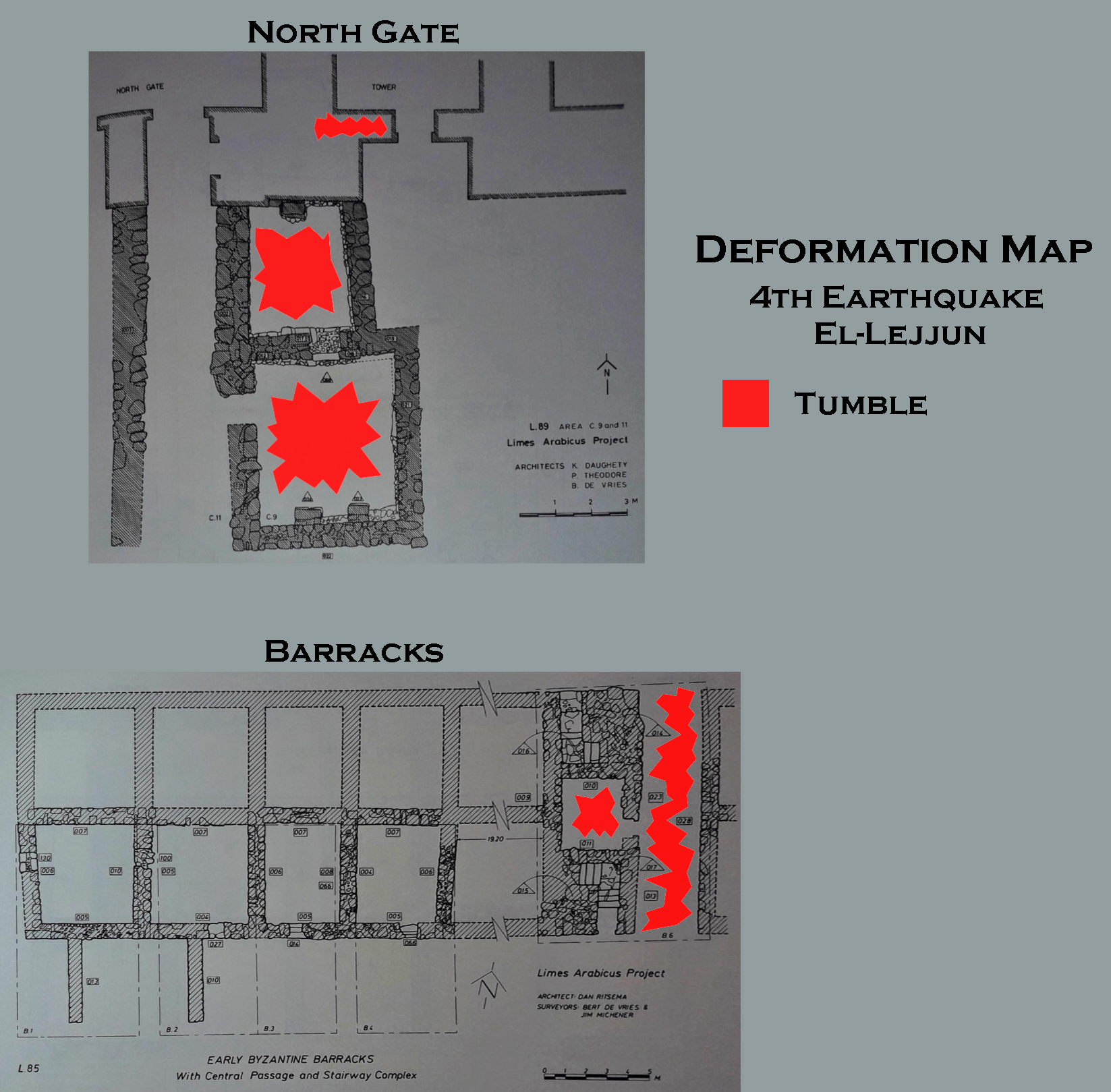 Deformation Map
Modified by JW from Fig.s 5.1 and 6.12 from Parker et al (2006)
-
Earthquake Archeological Effects chart
of Rodríguez-Pascua et al (2013: 221-224)
 Earthquake Archeological Effects (EAE)
Rodríguez-Pascua et al (2013: 221-224)
| Effect | Location | Image(s) | Description | Intensity |
|---|---|---|---|---|
| Roof collapse suggests displaced walls | Room A.13
Plan of the principia (headquarters building) in the Early Byzantine period Stern et al (1993 v. 3)
Plan of el-Lejjun fortress with excavation areas1980-89 modified by JW from Parker et al (2006)
Figure IPlan of el-Lejjun (ancient Betthorus). A later Roman legionary fortress east of the Dead Sea. Built around 300 CE for legio IV Martia (Courtesy S. T. Parker) Meyers et al (1997) |
Lain and Parker (2006:144) report that a beaten earth floor and ash layer in Room A.13 which ante-dated the
1st earthquake (Stratum VI-VB) was chock-full of tile fragmentssuggesting an apparent roof collapse due to an unknown cause. Such "collapse" debris was not found in any other excavation areas. |
VII + |
-
Earthquake Archeological Effects chart
of Rodríguez-Pascua et al (2013: 221-224)
Earthquake Archeological Effects (EAE)
Rodríguez-Pascua et al (2013: 221-224)
| Effect | Location | Image(s) | Description | Intensity |
|---|---|---|---|---|
| Collapsed walls | praetentura
Fig. 5.1 Plan of Area B: the Early Byzantine Barracks (Strata VA-IV) Parker et al (2006)
Plan of el-Lejjun fortress with excavation areas1980-89 modified by JW from Parker et al (2006)
Figure IPlan of el-Lejjun (ancient Betthorus). A later Roman legionary fortress east of the Dead Sea. Built around 300 CE for legio IV Martia (Courtesy S. T. Parker) Meyers et al (1997) |
The original limestone barracks in praetentura and possibly elsewhere in the fortress were leveled to their foundations. New chert barracks, only about half their former number, were erected along a slightly different alignment in both the praetentura and in the latera praetoria south of the principia. Rows of barrack-like rooms were erected on either side of the northern via principalis.- Parker (2006:120) |
VIII + | |
| Collapsed walls | principia
Plan of the principia (headquarters building) in the Early Byzantine period Stern et al (1993 v. 3)
Plan of el-Lejjun fortress with excavation areas1980-89 modified by JW from Parker et al (2006)
Figure IPlan of el-Lejjun (ancient Betthorus). A later Roman legionary fortress east of the Dead Sea. Built around 300 CE for legio IV Martia (Courtesy S. T. Parker) Meyers et al (1997) |
The principia also seems to have suffered extensive damage, requiring some portions to be completely rebuilt, such as the interior of the aedes, the rooms in the official block north of the aedes, and the rooms north of the central courtyard [of the principia].- Parker (2006:120) |
VIII + | |
| Collapsed walls | The mansio in the western
vicus
El-Lejjun: plan of a structure in the vicus (civilian settlement) Stern et al (1993 v. 3)
Plan of el-Lejjun fortress with excavation areas1980-89 modified by JW from Parker et al (2006)
Figure IPlan of el-Lejjun (ancient Betthorus). A later Roman legionary fortress east of the Dead Sea. Built around 300 CE for legio IV Martia (Courtesy S. T. Parker) Meyers et al (1997) |
The mansio in the western vicus was destroyed in 363 and never rebuilt.- Parker (2006:120) |
VIII + | |
| Displaced wallls suggested by Roof collapse | principia
Plan of the principia (headquarters building) in the Early Byzantine period Stern et al (1993 v. 3)
Plan of el-Lejjun fortress with excavation areas1980-89 modified by JW from Parker et al (2006)
Figure IPlan of el-Lejjun (ancient Betthorus). A later Roman legionary fortress east of the Dead Sea. Built around 300 CE for legio IV Martia (Courtesy S. T. Parker) Meyers et al (1997) |
The earthquake brought down tile roofs throughout the principia- Lain and Parker (2006:131) |
VII + | |
| Arch collapse | principia
Plan of the principia (headquarters building) in the Early Byzantine period Stern et al (1993 v. 3)
Plan of el-Lejjun fortress with excavation areas1980-89 modified by JW from Parker et al (2006)
Figure IPlan of el-Lejjun (ancient Betthorus). A later Roman legionary fortress east of the Dead Sea. Built around 300 CE for legio IV Martia (Courtesy S. T. Parker) Meyers et al (1997) |
The west arcade between the central courtyard and the cross hall of the principia fell while the major walls were left standing.- Lain and Parker (2006:131) |
VI + | |
| Fallen columns | A.7
Plan of el-Lejjun fortress with excavation areas 1980-89 modified by JW from Parker et al (2006)
Figure IPlan of el-Lejjun (ancient Betthorus). A later Roman legionary fortress east of the Dead Sea. Built around 300 CE for legio IV Martia (Courtesy S. T. Parker) Meyers et al (1997) |
Three engaged half and quarter columns with Nabatean style capitals were found in the earthquake debris.- Lain and Parker (2006:133) |
VI + | |
| Penetrative fractures - Fractured wall | Wall A.8.003 in principia
Plan of the principia (headquarters building) in the Early Byzantine period Stern et al (1993 v. 3)
Plan of el-Lejjun fortress with excavation areas1980-89 modified by JW from Parker et al (2006)
Figure IPlan of el-Lejjun (ancient Betthorus). A later Roman legionary fortress east of the Dead Sea. Built around 300 CE for legio IV Martia (Courtesy S. T. Parker) Meyers et al (1997) |
The wall contains a substantial crack running through the center of its eastern end- Lain and Parker (2006:151) |
VI + |
-
Earthquake Archeological Effects chart
of Rodríguez-Pascua et al (2013: 221-224)
Earthquake Archeological Effects (EAE)
Rodríguez-Pascua et al (2013: 221-224)
| Effect | Location | Image(s) | Description | Intensity |
|---|---|---|---|---|
| Collapsed walls and arches | Area B Barracks
Fig. 5.1 Plan of Area B: the Early Byzantine Barracks (Strata VA-IV) Parker et al (2006)
Plan of el-Lejjun fortress with excavation areas1980-89 modified by JW from Parker et al (2006)
Figure IPlan of el-Lejjun (ancient Betthorus). A later Roman legionary fortress east of the Dead Sea. Built around 300 CE for legio IV Martia (Courtesy S. T. Parker) Meyers et al (1997) |
Figure 8 Two fallen roof arches caused by earthquake in the barracks, from the north. Parker (1982) |
|
VIII + |
| Collapsed walls | principia and other buildings in the fortress
Plan of the principia (headquarters building) in the Early Byzantine period Stern et al (1993 v. 3)
Plan of el-Lejjun fortress with excavation areas1980-89 modified by JW from Parker et al (2006)
Figure IPlan of el-Lejjun (ancient Betthorus). A later Roman legionary fortress east of the Dead Sea. Built around 300 CE for legio IV Martia (Courtesy S. T. Parker) Meyers et al (1997) |
The earthquake damaged the principia and many other buildings within the fortress.- Parker (2006:121) |
VIII + | |
| Collapsed walls and roofs | Area N
Plan of el-Lejjun fortress with excavation areas 1980-89 modified by JW from Parker et al (2006)
Figure IPlan of el-Lejjun (ancient Betthorus). A later Roman legionary fortress east of the Dead Sea. Built around 300 CE for legio IV Martia (Courtesy S. T. Parker) Meyers et al (1997)
Fig. 8.1Plan of Area N showing three excavated rooms (N.1-3) Parker et al (2006) |
Fig. 8.3 West section of southwest corner balk of room N.3 Parker et al (2006)
Fig. 8.2Balk sections in room N.2 Parker et al (2006) |
|
VIII + |
-
Earthquake Archeological Effects chart
of Rodríguez-Pascua et al (2013: 221-224)
Earthquake Archeological Effects (EAE)
Rodríguez-Pascua et al (2013: 221-224)
| Effect | Location | Image(s) | Description | Intensity |
|---|---|---|---|---|
| Collapsed walls | various locations
Plan of the principia (headquarters building) in the Early Byzantine period Stern et al (1993 v. 3)
Plan of el-Lejjun fortress with excavation areas1980-89 modified by JW from Parker et al (2006)
Figure IPlan of el-Lejjun (ancient Betthorus). A later Roman legionary fortress east of the Dead Sea. Built around 300 CE for legio IV Martia (Courtesy S. T. Parker) Meyers et al (1997) |
At el-Lejjun, the seismic shock severely affected most parts of the fortress, including the principia, the barracks, the northwest angle tower, the church, and the rooms along the via principalis. Those structures attached to the deep foundations of the curtain wall, such as the horreum and the bath, seem to have better weathered the shock of 551 [JW: Late 6th century CE Inscription at Areopolis Quake a more likely candidate], but even these structures partially collapsed. The fortress was apparently then almost completely abandoned.- Parker (2006:121) |
VIII + | |
| Collapsed walls | principia
Plan of the principia (headquarters building) in the Early Byzantine period Stern et al (1993 v. 3)
Plan of el-Lejjun fortress with excavation areas1980-89 modified by JW from Parker et al (2006)
Figure IPlan of el-Lejjun (ancient Betthorus). A later Roman legionary fortress east of the Dead Sea. Built around 300 CE for legio IV Martia (Courtesy S. T. Parker) Meyers et al (1997) |
Lain and Parker (2006:132) report that the 3rd earthquake toppled original architecture which had survived the
previous two earthquakes and created heavy architectural tumble from walls and installations. |
VIII + | |
| Northward collapse of walls | principia
Plan of the principia (headquarters building) in the Early Byzantine period Stern et al (1993 v. 3)
Plan of el-Lejjun fortress with excavation areas1980-89 modified by JW from Parker et al (2006)
Figure IPlan of el-Lejjun (ancient Betthorus). A later Roman legionary fortress east of the Dead Sea. Built around 300 CE for legio IV Martia (Courtesy S. T. Parker) Meyers et al (1997) |
Lain and Parker (2006:132) report that the
direction of architectural collapse was from south to north and that much of the material fell in aligned patterns |
VIII + | |
| Northward collapsed wall preserving courses | Square A.2 - officium
Plan of the principia (headquarters building) in the Early Byzantine period Stern et al (1993 v. 3)
Plan of el-Lejjun fortress with excavation areas1980-89 modified by JW from Parker et al (2006)
Figure IPlan of el-Lejjun (ancient Betthorus). A later Roman legionary fortress east of the Dead Sea. Built around 300 CE for legio IV Martia (Courtesy S. T. Parker) Meyers et al (1997) |
Pl 4.11 Collapsed south wall of the A2, officium within the aedes. The wall fell in the earthquake of 551. View to the west. Parker et al (2006)
Uniformly collapsed wall - looking west - wall fell towards the north
Click on image to open in a new tab Photo by Jefferson Williams - 2 Feb. 2026 |
The entire south wall of the room had toppled northward to fill the officium with 18 rows of aligned wall blocks, representing collapsed courses of the wall. The fallen wall overlay roof tile debris that yielded Late Byzantine pottery.- Lain and Parker (2006:132) |
VIII + |
| Fallen and broken columns | groma - square A.7
Fig. 4.3 Plan of the western end of the via praetoria at its intersection with the groma Parker et al (2006)
Fig. 4.4Section through the south doorways of the groma, looking south Parker et al (2006)
Plan of el-Lejjun fortress with excavation areas1980-89 modified by JW from Parker et al (2006)
Figure IPlan of el-Lejjun (ancient Betthorus). A later Roman legionary fortress east of the Dead Sea. Built around 300 CE for legio IV Martia (Courtesy S. T. Parker) Meyers et al (1997) |
drums and capitals dislodged from half and quarter columns lay in aligned rows.- Lain and Parker (2006:132) |
V + or VIII + | |
| Collapsed walls | groma - square A.7
Fig. 4.3 Plan of the western end of the via praetoria at its intersection with the groma Parker et al (2006)
Fig. 4.4Section through the south doorways of the groma, looking south Parker et al (2006)
Plan of el-Lejjun fortress with excavation areas1980-89 modified by JW from Parker et al (2006)
Figure IPlan of el-Lejjun (ancient Betthorus). A later Roman legionary fortress east of the Dead Sea. Built around 300 CE for legio IV Martia (Courtesy S. T. Parker) Meyers et al (1997) |
ashlar limestone and chert blocks from adjacent walls tumbled into the groma's southwest corner- Lain and Parker (2006:132) |
VIII + | |
| Displaced wallls suggested by Roof collapse | groma - square A.7
Fig. 4.3 Plan of the western end of the via praetoria at its intersection with the groma Parker et al (2006)
Fig. 4.4Section through the south doorways of the groma, looking south Parker et al (2006)
Plan of el-Lejjun fortress with excavation areas1980-89 modified by JW from Parker et al (2006)
Figure IPlan of el-Lejjun (ancient Betthorus). A later Roman legionary fortress east of the Dead Sea. Built around 300 CE for legio IV Martia (Courtesy S. T. Parker) Meyers et al (1997) |
The guardroom that adjoined the gate hall was filled with upended basalt roof beams- Lain and Parker (2006:132) |
VII + | |
| Collapsed arches | Square A.1
Plan of the principia (headquarters building) in the Early Byzantine period Stern et al (1993 v. 3)
Plan of el-Lejjun fortress with excavation areas1980-89 modified by JW from Parker et al (2006)
Figure IPlan of el-Lejjun (ancient Betthorus). A later Roman legionary fortress east of the Dead Sea. Built around 300 CE for legio IV Martia (Courtesy S. T. Parker) Meyers et al (1997) |
arches of the south portico collapsed in aligned rows between piers of the colonnade- Lain and Parker (2006:132) |
VI + | |
| Displaced walls suggested by Roof collapse | aedes
Plan of the principia (headquarters building) in the Early Byzantine period Stern et al (1993 v. 3)
Plan of el-Lejjun fortress with excavation areas1980-89 modified by JW from Parker et al (2006)
Figure IPlan of el-Lejjun (ancient Betthorus). A later Roman legionary fortress east of the Dead Sea. Built around 300 CE for legio IV Martia (Courtesy S. T. Parker) Meyers et al (1997) |
first the roof tile caved in.- Lain and Parker (2006:132) |
VII + | |
| Fallen column | aedes
Plan of the principia (headquarters building) in the Early Byzantine period Stern et al (1993 v. 3)
Plan of el-Lejjun fortress with excavation areas1980-89 modified by JW from Parker et al (2006)
Figure IPlan of el-Lejjun (ancient Betthorus). A later Roman legionary fortress east of the Dead Sea. Built around 300 CE for legio IV Martia (Courtesy S. T. Parker) Meyers et al (1997) |
Next, the three sided podium collapsed, with blocks from its flagstone surface and barrel-vaulted substructures rolling down into the center of the shrine- Lain and Parker (2006:132) |
V + | |
| Collapsed walls | aedes
Plan of the principia (headquarters building) in the Early Byzantine period Stern et al (1993 v. 3)
Plan of el-Lejjun fortress with excavation areas1980-89 modified by JW from Parker et al (2006)
Figure IPlan of el-Lejjun (ancient Betthorus). A later Roman legionary fortress east of the Dead Sea. Built around 300 CE for legio IV Martia (Courtesy S. T. Parker) Meyers et al (1997) |
Finally the aedes walls toppled, creating a sloping stratum of jumbled limestone wall blocks.- Lain and Parker (2006:132) |
VIII + | |
| Collapsed walls and fallen column | aedes
Plan of the principia (headquarters building) in the Early Byzantine period Stern et al (1993 v. 3)
Plan of el-Lejjun fortress with excavation areas1980-89 modified by JW from Parker et al (2006)
Figure IPlan of el-Lejjun (ancient Betthorus). A later Roman legionary fortress east of the Dead Sea. Built around 300 CE for legio IV Martia (Courtesy S. T. Parker) Meyers et al (1997) |
The debris from both the tumbled podium and the collapsed walls of the aedes yielded Late Byzantine pottery.- Lain and Parker (2006:132) |
VIII + | |
| Collapsed roof and walls | A.15
Plan of the principia (headquarters building) in the Early Byzantine period Stern et al (1993 v. 3)
Plan of el-Lejjun fortress with excavation areas1980-89 modified by JW from Parker et al (2006)
Figure IPlan of el-Lejjun (ancient Betthorus). A later Roman legionary fortress east of the Dead Sea. Built around 300 CE for legio IV Martia (Courtesy S. T. Parker) Meyers et al (1997) |
[A subsoil tumble layer in A.15.003] covered the entire square and exhibited marked declivity from south to north, contained ashlar limestone blocks, chert blocks, and basalt roof beams arrayed in patterns indicative of seismic collapse. The basalt beams were concentrated in the south end of the square above the sidewalk. The beams measured 1.75 m in length, and all lay with their short ends oriented north-south. The limestone and chert blocks lay in two fairly regular rows and extended east-west across the square, along the same line as the A.15.008 curb- Lain and Parker (2006:134) |
VIII + | |
| Collapsed walls | A.13.007
Plan of the principia (headquarters building) in the Early Byzantine period Stern et al (1993 v. 3)
Plan of el-Lejjun fortress with excavation areas1980-89 modified by JW from Parker et al (2006)
Figure IPlan of el-Lejjun (ancient Betthorus). A later Roman legionary fortress east of the Dead Sea. Built around 300 CE for legio IV Martia (Courtesy S. T. Parker) Meyers et al (1997) |
Lain and Parker (2006:154) report collapsed Walls in tumble layer | VIII + | |
| Collapsed walls | Areas B and L
Plan of el-Lejjun fortress with excavation areas 1980-89 modified by JW from Parker et al (2006)
Figure IPlan of el-Lejjun (ancient Betthorus). A later Roman legionary fortress east of the Dead Sea. Built around 300 CE for legio IV Martia (Courtesy S. T. Parker) Meyers et al (1997) |
collapse of most of the remaining barrack rooms still standing in Areas B and L- Groot et al (2006:185) |
VIII + | |
| Collapsed walls and ceilings | Northwest Angle Tower - C.3 and C.7
Fig. 6.3 Plan and section of the northwest angle tower of the el-Lejjun fortress Parker et al (2006)
Fig. 6.4Plan and section of the interval tower of the el-Lejjun fortress Parker et al (2006)
Fig. 6.6Plans and sections of the northwest angle tower stairway Parker et al (2006)
Fig. 6.7Restored section C-D (see Fig. 6.6) showing the angle tower with either two or three floors Parker et al (2006)
Plan of el-Lejjun fortress with excavation areas1980-89 modified by JW from Parker et al (2006)
Figure IPlan of el-Lejjun (ancient Betthorus). A later Roman legionary fortress east of the Dead Sea. Built around 300 CE for legio IV Martia (Courtesy S. T. Parker) Meyers et al (1997) |
Pl 6.1 The northeast room (C.3) within the Angle Tower. The two meter sticks rest in the window. Note the arch springers to the left and right. In the foreground is the lower layer of tumble within the room. View to the south. Parker et al (2006) |
deVries et al (2006:196) reports the collapse of upper floors and ceilings | VIII + |
| Collapsed arches | Northwest Angle Tower - C.3 and C.7
Fig. 6.3 Plan and section of the northwest angle tower of the el-Lejjun fortress Parker et al (2006)
Fig. 6.4Plan and section of the interval tower of the el-Lejjun fortress Parker et al (2006)
Fig. 6.6Plans and sections of the northwest angle tower stairway Parker et al (2006)
Fig. 6.7Restored section C-D (see Fig. 6.6) showing the angle tower with either two or three floors Parker et al (2006)
Plan of el-Lejjun fortress with excavation areas1980-89 modified by JW from Parker et al (2006)
Figure IPlan of el-Lejjun (ancient Betthorus). A later Roman legionary fortress east of the Dead Sea. Built around 300 CE for legio IV Martia (Courtesy S. T. Parker) Meyers et al (1997) |
destruction of all arches except the southern ones in Room C.3- deVries et al (2006:196) |
VI + | |
| Collapsed arches and ceiling | Northwest Angle Tower - C.7
Fig. 6.3 Plan and section of the northwest angle tower of the el-Lejjun fortress Parker et al (2006)
Fig. 6.4Plan and section of the interval tower of the el-Lejjun fortress Parker et al (2006)
Fig. 6.6Plans and sections of the northwest angle tower stairway Parker et al (2006)
Fig. 6.7Restored section C-D (see Fig. 6.6) showing the angle tower with either two or three floors Parker et al (2006)
Plan of el-Lejjun fortress with excavation areas1980-89 modified by JW from Parker et al (2006)
Figure IPlan of el-Lejjun (ancient Betthorus). A later Roman legionary fortress east of the Dead Sea. Built around 300 CE for legio IV Martia (Courtesy S. T. Parker) Meyers et al (1997) |
deVries et al (2006:192) reports a collapsed ceiling caused by arch collapse and
notes that the earthquake which collapsed the ceiling must have been quite a force to destroy something so sturdy |
IX + (upgraded to IX based on deVries et al (2006) observation) | |
| Collapsed arches and roof | Room N.2
Plan of el-Lejjun fortress with excavation areas 1980-89 modified by JW from Parker et al (2006)
Figure IPlan of el-Lejjun (ancient Betthorus). A later Roman legionary fortress east of the Dead Sea. Built around 300 CE for legio IV Martia (Courtesy S. T. Parker) Meyers et al (1997)
Fig. 8.1Plan of Area N showing three excavated rooms (N.1-3) Parker et al (2006) |
Pl 8.7 View of Room N.2, with collapsed arches and roofing slabs, probably from the 551 earthquake. View to the south. Parker et al (2006)
Fig. 8.2Balk sections in room N.2 Parker et al (2006) |
Parker et al (2006)
reports collapsed Arches and Roofing slabs in room N.2 which probablyfell during this earthquake |
VI + |
| Collapsed walls | Horreum
Plan of el-Lejjun fortress with excavation areas 1980-89 modified by JW from Parker et al (2006)
Figure IPlan of el-Lejjun (ancient Betthorus). A later Roman legionary fortress east of the Dead Sea. Built around 300 CE for legio IV Martia (Courtesy S. T. Parker) Meyers et al (1997) |
Stratum III occupation ended in all three rooms with massive wall collapse, perhaps resulting from the 551 earthquake [JW: more likely the late 6th century Inscription at Areopolis Quake]- Crawford (2006:238) |
VIII + |
-
Earthquake Archeological Effects chart
of Rodríguez-Pascua et al (2013: 221-224)
Earthquake Archeological Effects (EAE)
Rodríguez-Pascua et al (2013: 221-224)
| Effect | Location | Image(s) | Description | Intensity |
|---|---|---|---|---|
| Collapsed walls and arches | Barracks - Room B.6
Fig. 5.1 Plan of Area B: the Early Byzantine Barracks (Strata VA-IV) Parker et al (2006)
Plan of el-Lejjun fortress with excavation areas1980-89 modified by JW from Parker et al (2006)
Figure IPlan of el-Lejjun (ancient Betthorus). A later Roman legionary fortress east of the Dead Sea. Built around 300 CE for legio IV Martia (Courtesy S. T. Parker) Meyers et al (1997) |
|
VIII + | |
| Collapsed walls | North Gate - C.9.008 (north room), C.9.009 (south room) and C.9.005 (stairwell)
Fig. 6.8 Plan of the north gate (porta principalis sinistra) of the el-Lejjun fortress Parker et al (2006)
Plan of the Porta Principalis sinistra after partial excavation by the Limes Arabicus projectBetthorus legionary camp - excavation plan of the Porta principalis sinistra , Limes Arabicus Project, Jordan. Click on photo to open a high resolution magnifiable image in a new tab Mediatus - Wikipedia - CC BY-SA 3.0
Fig. 6.12Plan of Late Byzantine domestic complex near the north gate Parker et al (2006)
The north-western area of the legionary camp with the porta principalis sinistra ,
the military baths, the cistern and accommodation buildings. Only the older, late Roman
expansion phase is taken into account in the figureLegion camp Betthorus - Plan of the excavations, Limes Arabicus Project, Jordan. Only the late Roman expansion phase is taken into account. Click on photo to open a high resolution magnifiable image in a new tab Mediatus - Wikipedia - CC BY-SA 3.0
Plan of el-Lejjun fortress with excavation areas1980-89 modified by JW from Parker et al (2006)
Figure IPlan of el-Lejjun (ancient Betthorus). A later Roman legionary fortress east of the Dead Sea. Built around 300 CE for legio IV Martia (Courtesy S. T. Parker) Meyers et al (1997) |
deVries et al (2006:207) reports full scale destruction in layers above 3rd earthquake debris and post-earthquake occupation layerswhich contained Late Byzantine/Umayyad and Umayyad sherds. Subsoil/tumble was found in C.9.008 (north room), C.9.009 (south room) and C.9.005 (stairwell) which bear ample witness to the destruction of the rooms, perhaps in the Umayyad period |
VIII + |