Sepphoris
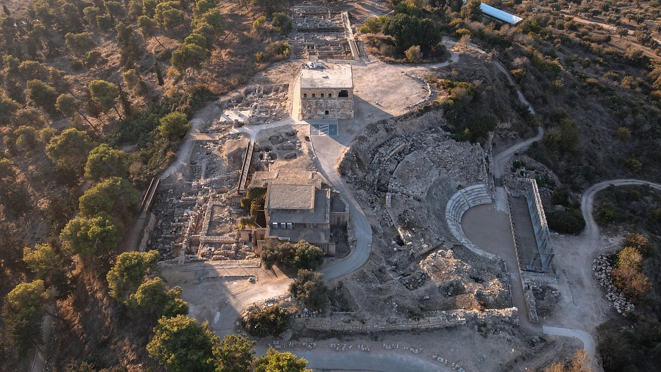
 Aerial View of Sepphoris
click on image to open a high resolution magnifiable image in a new tab
AVRANGR - Wikipedia - CC BY-SA 4.0
| Transliterated Name | Source | Name |
|---|---|---|
| Sepphoris | Ancient Greek | Σεπφωρίς |
| Tzipori | Hebrew | צִפּוֹרִי |
| Kitron | Hebrew | |
| Rakkath | Hebrew | |
| Saffuriya | Arabic | صفورية |
| Eirenopolis | Greek | |
| Autocratoris | Greek | Αὐτοκρατορίδα |
| Diocaesarea | Greek | διοκαισαρεία |
| Le Saphorie | Crusader |
- Location Map from
Strange et al. (2006)
 Location Map
Strange et al. (2006) - Gallus Revolt Location
Map from Nathanson (1986)
 Gallus Revolt Location Map
Nathanson (1986)
- Aerial View of Sepphoris
from wikipedia
 Aerial View of Sepphoris
click on image to open a high resolution magnifiable image in a new tab AVRANGR - Wikipedia - CC BY-SA 4.0 - Annotated Satellite View
of Sepphoris and surroundings from BibleWalks.com
- Aerial Photo of Tzipori
Acropolis from pixabay
- Sepphoris in Google Earth
 Sepphoris
click on image to explore this site on a new tab in Google Earth - Sepphoris on govmap.gov.il
 Sepphoris
click on image to explore this site on a new tab in govmap.gov.il


- Site Plan from
Meyers et al. (1992)
 Plan of the site showing location of excavated areas and of major features (theater, citadel, villa with mosaic)
Meyers et al. (1992) - Site Plan from
Stern et al. (1993 v.4)
 Sepphoris: general plan of the excavations.
Stern et al. (1993 v.4) - Site Plan from
National Park of Israel
 Site Plan of Tzipori.
National Park of Israel
- Site Plan from
Meyers et al. (1992)
Plan of the site showing location of excavated areas and of major features (theater, citadel, villa with mosaic)
Meyers et al. (1992) - Site Plan from
Stern et al. (1993 v.4)
Sepphoris: general plan of the excavations.
Stern et al. (1993 v.4) - Site Plan from
National Park of Israel
Site Plan of Tzipori.
National Park of Israel
- Fig. 10 Plan of the
eastern side of the acropolis from Nagy et al. (1996)
 Fig. 10
Plan of the eastern side of the acropolis showing:
- The Citadel
- The Theater
- The Dionysos Mosaic Building
- The Storehouse
Courtesy: The Hebrew University Expedition
Nagy et al. (1996)
- Fig. 10 Plan of the
eastern side of the acropolis from Nagy et al. (1996)
Fig. 10
Plan of the eastern side of the acropolis showing:
- The Citadel
- The Theater
- The Dionysos Mosaic Building
- The Storehouse
Courtesy: The Hebrew University Expedition
Nagy et al. (1996)
- Plan of residential
area on western side of the acropolis from Meyers et al. (1992)
 Plan of residential area on western side of the acropolis. A major east-west
road runs across the northern edge of this domestic area, which was inhabited
continually from Hellenistic times (ca. 100 B.C.E.) to the Byzantine era (seventh century C.E.).
Plan of residential area on western side of the acropolis. A major east-west
road runs across the northern edge of this domestic area, which was inhabited
continually from Hellenistic times (ca. 100 B.C.E.) to the Byzantine era (seventh century C.E.).
Meyers et al. (1992)
- Plan of residential
area on western side of the acropolis from Meyers et al. (1992)
Plan of residential area on western side of the acropolis. A major east-west
road runs across the northern edge of this domestic area, which was inhabited
continually from Hellenistic times (ca. 100 B.C.E.) to the Byzantine era (seventh century C.E.).
Meyers et al. (1992)
- Fig. 46 Plan of the
Dionysos mosaic building from Nagy et al. (1996)
 Fig. 46
Plan of the Dionysos mosaic building showing the location of the triclinium (reception hall) mosaic, near the top center of the plan.
Courtesy: The Hebrew University Expedition
Nagy et al. (1996) - Plan of villa with
mosaic floor from Meyers et al. (1992)
 Plan of villa with mosaic
floor. A peristyle
courtyard, with
reflecting pool, is
situated to the south of
the triclinium (banquet
hall). Various rooms,
some with plain or
geometric mosaic floors,
surround the central
banquet room.
Plan of villa with mosaic
floor. A peristyle
courtyard, with
reflecting pool, is
situated to the south of
the triclinium (banquet
hall). Various rooms,
some with plain or
geometric mosaic floors,
surround the central
banquet room.
Meyers et al. (1992)
- Fig. 46 Plan of the
Dionysos mosaic building from Nagy et al. (1996)
Fig. 46
Plan of the Dionysos mosaic building showing the location of the triclinium (reception hall) mosaic, near the top center of the plan.
Courtesy: The Hebrew University Expedition
Nagy et al. (1996) - Plan of villa with
mosaic floor from Meyers et al. (1992)
Plan of villa with mosaic
floor. A peristyle
courtyard, with
reflecting pool, is
situated to the south of
the triclinium (banquet
hall). Various rooms,
some with plain or
geometric mosaic floors,
surround the central
banquet room.
Meyers et al. (1992)
- Fig. 32 Plan of the
fifth-century C.E. Nile festival building from Nagy et al. (1996)
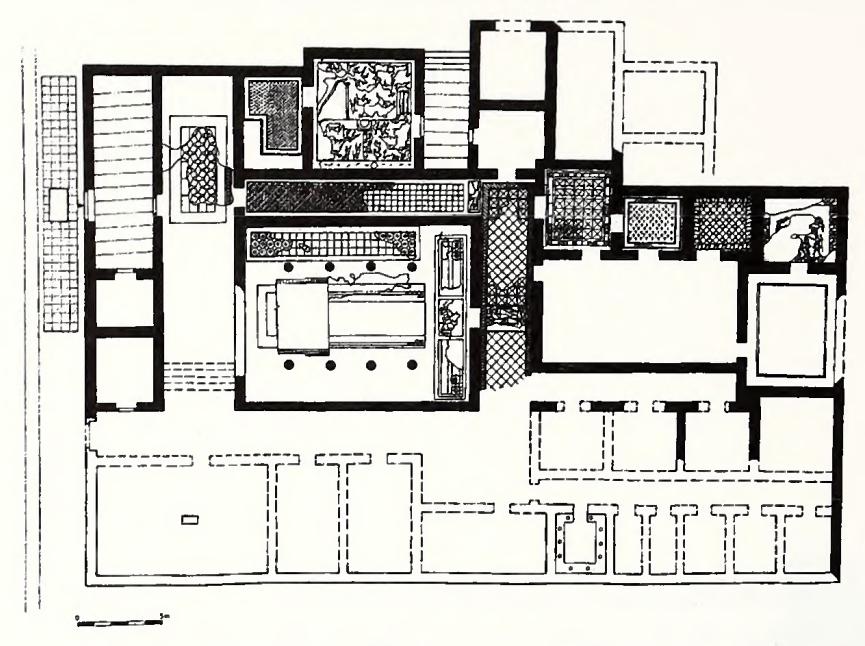 Fig. 32
Plan of the fifth-century C.E. Nile festival building.
Courtesy: The Hebrew University Expedition
Nagy et al. (1996)
- Fig. 32 Plan of the
fifth-century C.E. Nile festival building from Nagy et al. (1996)
Fig. 32
Plan of the fifth-century C.E. Nile festival building.
Courtesy: The Hebrew University Expedition
Nagy et al. (1996)
- Fig. 1.01 Field I
Squares from Strange et al. (2006)
 Fig. 1.01
Field I Squares with Dates excavated
Strange et al. (2006) - Fig. 6.03 USF Excavation
Squares superimposed on Waterman's excavations from the 1930s from Strange et al. (2006)
 Fig. 6.03
Waterman's finds with USF Squares
Strange et al. (2006)
- Fig. 1.01 Field I
Squares from Strange et al. (2006)
Fig. 1.01
Field I Squares with Dates excavated
Strange et al. (2006) - Fig. 6.03 USF Excavation
Squares superimposed on Waterman's excavations from the 1930s from Strange et al. (2006)
Fig. 6.03
Waterman's finds with USF Squares
Strange et al. (2006)
- Fig. 4.01 Location of
Squares 1-3 and Tower from Strange et al. (2006)
 Fig. 4.01
Location of Squares 1-3 and Tower
Strange et al. (2006)
- Fig. 4.01 Location of
Squares 1-3 and Tower from Strange et al. (2006)
Fig. 4.01
Location of Squares 1-3 and Tower
Strange et al. (2006)
- Fig. 2 The Basilica
from Waterman et al. (1937)
 Fig. 2
The Basilica
Waterman et al. (1937)
- Fig. 2 The Basilica
from Waterman et al. (1937)
Fig. 2
The Basilica
Waterman et al. (1937)
- The Theater (restored)
from Waterman et al. (1937)
 The Theater (restored)
Waterman et al. (1937)
- The Theater (restored)
from Waterman et al. (1937)
The Theater (restored)
Waterman et al. (1937)
- Illustration of public
area fo the city from Meyers et al. (1992)
 Drawing of public area of the city, showing citadel, theater, and villa with mosaic floor (on right).
Meyers et al. (1992) - Fig. 52 Reconstruction
of the eastern basilical building from Nagy et al. (1996)
 Fig. 52
Reconstruction of the eastern basilical building, showing the main entrance and its four porches opening onto the cardo (main north-south street).
Courtesy: University of South Florida Expedition
Nagy et al. (1996)
- Illustration of public
area fo the city from Meyers et al. (1992)
Drawing of public area of the city, showing citadel, theater, and villa with mosaic floor (on right).
Meyers et al. (1992) - Fig. 52 Reconstruction
of the eastern basilical building from Nagy et al. (1996)
Fig. 52
Reconstruction of the eastern basilical building, showing the main entrance and its four porches opening onto the cardo (main north-south street).
Courtesy: University of South Florida Expedition
Nagy et al. (1996)
- Fig. 4.03 Square I.1,
Southeast Balk showing 1024 and 1025 destruction layers from Strange et al. (2006)
 Fig. 4.03
Square I.12, Southeast Balk
JW: Layers 1024 and 1025 are mid 4th century CE destruction layers
Strange et al. (2006) - Fig. 6.08 Square I.12,
North Balk from Strange et al. (2006)
 Fig. 6.08
Square I.12, North Balk
Strange et al. (2006) - Fig. 6.09 Square I.12,
East Balk from Strange et al. (2006)
 Fig. 6.09
Square I.12, East Balk
Strange et al. (2006)
- Fig. 4.03 Square I.1,
Southeast Balk showing 1024 and 1025 destruction layers from Strange et al. (2006)
Fig. 4.03
Square I.12, Southeast Balk
JW: Layers 1024 and 1025 are mid 4th century CE destruction layers
Strange et al. (2006) - Fig. 6.08 Square I.12,
North Balk from Strange et al. (2006)
Fig. 6.08
Square I.12, North Balk
Strange et al. (2006) - Fig. 6.09 Square I.12,
East Balk from Strange et al. (2006)
Fig. 6.09
Square I.12, East Balk
Strange et al. (2006)
- Photo of citadel from
Meyers et al. (1992)
 The citadel, or fort, of Sepphoris is the most prominent structure on the site today and can be seen from as
far away as Nazareth, several miles to the east. Its foundations may date to the Byzantine period, but it has
been rebuilt many times. Most of the present cornerstones are rubble filed Roman sarcophagi that were
probably incorporated into the building in Byzantine or Crusader times. The most recent rebuilding took
place in the late nineteenth century, when Abdul Hamid (1816-1909) had the structure rebuilt for use
as a schoolhouse. It was used as such by the local Arab villagers until the 1948 war.
The citadel, or fort, of Sepphoris is the most prominent structure on the site today and can be seen from as
far away as Nazareth, several miles to the east. Its foundations may date to the Byzantine period, but it has
been rebuilt many times. Most of the present cornerstones are rubble filed Roman sarcophagi that were
probably incorporated into the building in Byzantine or Crusader times. The most recent rebuilding took
place in the late nineteenth century, when Abdul Hamid (1816-1909) had the structure rebuilt for use
as a schoolhouse. It was used as such by the local Arab villagers until the 1948 war.
Meyers et al. (1992) - Fig. 9 Photo of citadel
and theater from Nagy et al. (1996)
 Fig. 9
The Roman theater against the backdrop of the Crusader/ Ottoman citadel on the summit of the Sepphoris acropolis. Constructed at the end of the first century C.E. or later, the theater could seat around 4,500 spectators.
Photo: Ehud Netzer
Nagy et al. (1996)
- Photo of citadel from
Meyers et al. (1992)
The citadel, or fort, of Sepphoris is the most prominent structure on the site today and can be seen from as
far away as Nazareth, several miles to the east. Its foundations may date to the Byzantine period, but it has
been rebuilt many times. Most of the present cornerstones are rubble filed Roman sarcophagi that were
probably incorporated into the building in Byzantine or Crusader times. The most recent rebuilding took
place in the late nineteenth century, when Abdul Hamid (1816-1909) had the structure rebuilt for use
as a schoolhouse. It was used as such by the local Arab villagers until the 1948 war.
Meyers et al. (1992) - Fig. 9 Photo of citadel
and theater from Nagy et al. (1996)
Fig. 9
The Roman theater against the backdrop of the Crusader/ Ottoman citadel on the summit of the Sepphoris acropolis. Constructed at the end of the first century C.E. or later, the theater could seat around 4,500 spectators.
Photo: Ehud Netzer
Nagy et al. (1996)

 Table 3
Proposed Phases of the Villa
Strange et al. (2006)
Phase 3 began with renovation and changes within the building in the early second century C.E. Chamber 219. the chamber with bench and niche, was fashioned from the earlier, larger chamber by building the heavy wall that divides C219 from its northern neighbor. C219 underwent intensive use through the third century C.E., if not the early fourth. Since the staircase down from Square I was blocked, it follows that access to this and other chambers moved from the staircase to other means. Perhaps this is when the west wall of C216 was broken through to C217. These and other changes (see square by square analysis above) may be related to the changes in chamber 203 under Square I.3. This chamber was changed to dry storage about the same time. Phase 3 ends in mid-fourth century.
Table 3Proposed Phases of the Villa
Strange et al. (2006)
Phase 4 began with the abandonment of the villa, its burning, its dismantling by squatters, and finally its filling, which accounts for its disappearance. The abandonment appears not to have been sudden. The items associated with daily life were not simply smashed violently, as in warfare. On the contrary, most appear to have been taken at leisure, either by the occupants or by others who were not in a hurry. The only intact pottery vessels were lamps in the underground chambers.
The abandonment of the villa was followed by reconfiguration of space by squatters in Square I.12 and a burning, visible as Locus 12016 in Square I.12. After the burn someone began dismantling the walls, perhaps for building stones for another structure. The workers simply lifted the stones from their settings, not breaking them. In other words, there were no scatters of crumbled building stones on the floors associated with the rooms. Therefore the Villa was not smashed, but dismantled. The dismantling was not complete, as the last two or three courses of stones usually were in position in our squares. This is also true of the area as depicted in Waterman’s Preliminary Report. Pl. 3, where the walls in the photo do not exceed three courses in height.
Phase 4 must lie between 351 and 361 C.E., judging from the stratigraphy and the coins. While it is theoretically possible that the earthquake of 363 C.E. destroyed the Villa, it is not likely, for the simple reason that no one repaired the Villa or rebuilt it, nor did excavation reveal smashed stones or walls that were thrown down. In fact, all of the rooms that we probed were filled with erosion and deliberate fill. It appears that it was still possible for visitors to enter the underground chambers, which now began to fill with erosion from the surface. Visitors left more or less intact 4th century lamps on top the eroded debris when they left. Phase 4 ends with the filling in of the Villa, and presumably the entire 90 by 190 m. at the top surrounded by a wall that cut across the cavea of the theater.
Table 3Proposed Phases of the Villa
Strange et al. (2006)
Phase 5 was the period of Byzantine use wherein the fill increased substantially. There are no coherent structures to associate with this period. In the area of the villa there were a series of thick lime and clays layers that provided walking surfaces. The lime increased the alkalinity of these surfaces and controlled the growth of weeds and grass.
The most likely use is for some kind of military occupation, given the notice in the Notitzia Dignitatum. Phase 5 appears to last from 360 to the end of the 6th century C.E.
| Effect | Location | Image(s) | Description |
|---|---|---|---|
|
Splendid Villa and perhaps even the adjacent theater
Sepphoris: general plan of the excavations.Stern et al. (1993 v.4)
Drawing of public area of the city, showing citadel, theater, and villa with mosaic floor (on right).Meyers et al. (1992)
Plan of villa with mosaic
floor. A peristyle
courtyard, with
reflecting pool, is
situated to the south of
the triclinium (banquet
hall). Various rooms,
some with plain or
geometric mosaic floors,
surround the central
banquet room.Meyers et al. (1992) |
|
|
|
Square I.12
Sepphoris: general plan of the excavations. Stern et al. (1993 v.4)
Drawing of public area of the city, showing citadel, theater, and villa with mosaic floor (on right).Meyers et al. (1992)
Fig. 6.03Waterman's finds with USF Squares Strange et al. (2006) |
Fig. 6.08 Square I.12, North Balk Strange et al. (2006)
Fig. 6.09Square I.12, East Balk Strange et al. (2006) |
|
|
East Balk of Square I.10
Sepphoris: general plan of the excavations. Stern et al. (1993 v.4)
Drawing of public area of the city, showing citadel, theater, and villa with mosaic floor (on right).Meyers et al. (1992)
Fig. 6.03Waterman's finds with USF Squares Strange et al. (2006) |
|
|
|
Theater
Sepphoris: general plan of the excavations. Stern et al. (1993 v.4)
Drawing of public area of the city, showing citadel, theater, and villa with mosaic floor (on right).Meyers et al. (1992)
The Theater (restored) Waterman et al. (1937) |
|
|
|
Trench S I south of the Fort and Room 10
Sepphoris: general plan of the excavations. Stern et al. (1993 v.4)
Drawing of public area of the city, showing citadel, theater, and villa with mosaic floor (on right).Meyers et al. (1992)
Fig. 6.03Waterman's finds with USF Squares Strange et al. (2006) |
|
|
|
Residential Quarter on the Western Summit
Sepphoris: general plan of the excavations. Stern et al. (1993 v.4)
Drawing of public area of the city, showing citadel, theater, and villa with mosaic floor (on right).Meyers et al. (1992)
Plan of residential area on western side of the acropolis. A major east-west
road runs across the northern edge of this domestic area, which was inhabited
continually from Hellenistic times (ca. 100 B.C.E.) to the Byzantine era (seventh century C.E.).Meyers et al. (1992) |
|
|
|
Eastern Basilical Building
Sepphoris: general plan of the excavations. Stern et al. (1993 v.4)
Fig. 52Reconstruction of the eastern basilical building, showing the main entrance and its four porches opening onto the cardo (main north-south street). Courtesy: University of South Florida Expedition Nagy et al. (1996) |
|
| Effect | Location | Image(s) | Description |
|---|---|---|---|
|
"Basilica" of
Waterman et al. (1937) uncovered in Trench S II
Sepphoris: general plan of the excavations. Stern et al. (1993 v.4)
Drawing of public area of the city, showing citadel, theater, and villa with mosaic floor (on right).Meyers et al. (1992)
Fig. 6.03Waterman's finds with USF Squares Strange et al. (2006) |
|
| Effect | Location | Image(s) | Description |
|---|---|---|---|
| Wall Repairs | Mashad Pool |
 Mashad Pool in Tzipori may show evidence of wall repairs
Click on image to open a high resolution magnifiable image in a new tab Photo by Jefferson Williams 18 April 2025 |
Unsure if wall repairs are ancient or modern and if they were a response to seismic damage |
| Dented Pavement | in or near Orpheus Mosaic - possibly in the Agora |
 Dented Pavement in or near Orpheus Mosaic - possibly in the Agora - in Tzipori
Photo by Jefferson Williams 18 April 2025  Dented Pavement in or near Orpheus Mosaic - possibly in the Agora - in Tzipori
Photo by Jefferson Williams 18 April 2025  Dented Pavement in or near Orpheus Mosaic - possibly in the Agora - in Tzipori
Photo by Jefferson Williams 18 April 2025 |
Dented Pavement may be due to roof collapse which may have occurred during seismic activiy |
| Collapse ? | one side of the ampitheater |
 Collapse (?) on one side of the ampitheater in Tzipori
Photo by Jefferson Williams 18 April 2025  Collapse (?) on one side of the ampitheater in Tzipori
Photo by Jefferson Williams 18 April 2025 |
? |
| Collapse ? | residential quarter with all the mikvehs just west of the acropolis |
 Collapse (?) in the residential quarter with all the mikvehs just west of the acropolis in Tzipori
Photo by Jefferson Williams 18 April 2025 |
? |
| Wall damage ? | residential quarter with all the mikvehs just west of the acropolis |
 Wall damage (?) in the residential quarter with all the mikvehs just west of the acropolis in Tzipori
Photo by Jefferson Williams 18 April 2025 |
? |
| Slumped Wall | ? |
 Slumped Wall in Tzipori
Photo by Jefferson Williams 18 April 2025 |
Upper right corner of wall slumped down and to the right |
-
Earthquake Archeological Effects chart
of Rodríguez-Pascua et al (2013: 221-224)
 Earthquake Archeological Effects (EAE)
Rodríguez-Pascua et al (2013: 221-224)
| Effect | Location | Image(s) | Description | Intensity |
|---|---|---|---|---|
|
Caesarea |
|
|
-
Earthquake Archeological Effects chart
of Rodríguez-Pascua et al (2013: 221-224)
Earthquake Archeological Effects (EAE)
Rodríguez-Pascua et al (2013: 221-224)
| Effect | Location | Image(s) | Description | Intensity |
|---|---|---|---|---|
|
Splendid Villa and perhaps even the adjacent theater
Sepphoris: general plan of the excavations.Stern et al. (1993 v.4)
Drawing of public area of the city, showing citadel, theater, and villa with mosaic floor (on right).Meyers et al. (1992)
Plan of villa with mosaic
floor. A peristyle
courtyard, with
reflecting pool, is
situated to the south of
the triclinium (banquet
hall). Various rooms,
some with plain or
geometric mosaic floors,
surround the central
banquet room.Meyers et al. (1992) |
|
|
|
|
Square I.12
Sepphoris: general plan of the excavations. Stern et al. (1993 v.4)
Drawing of public area of the city, showing citadel, theater, and villa with mosaic floor (on right).Meyers et al. (1992)
Fig. 6.03Waterman's finds with USF Squares Strange et al. (2006) |
Fig. 6.08 Square I.12, North Balk Strange et al. (2006)
Fig. 6.09Square I.12, East Balk Strange et al. (2006) |
|
|
|
East Balk of Square I.10
Sepphoris: general plan of the excavations. Stern et al. (1993 v.4)
Drawing of public area of the city, showing citadel, theater, and villa with mosaic floor (on right).Meyers et al. (1992)
Fig. 6.03Waterman's finds with USF Squares Strange et al. (2006) |
|
|
|
|
Theater
Sepphoris: general plan of the excavations. Stern et al. (1993 v.4)
Drawing of public area of the city, showing citadel, theater, and villa with mosaic floor (on right).Meyers et al. (1992)
The Theater (restored) Waterman et al. (1937) |
|
|
|
|
Trench S I south of the Fort and Room 10
Sepphoris: general plan of the excavations. Stern et al. (1993 v.4)
Drawing of public area of the city, showing citadel, theater, and villa with mosaic floor (on right).Meyers et al. (1992)
Fig. 6.03Waterman's finds with USF Squares Strange et al. (2006) |
|
|
|
|
Residential Quarter on the Western Summit
Sepphoris: general plan of the excavations. Stern et al. (1993 v.4)
Drawing of public area of the city, showing citadel, theater, and villa with mosaic floor (on right).Meyers et al. (1992)
Plan of residential area on western side of the acropolis. A major east-west
road runs across the northern edge of this domestic area, which was inhabited
continually from Hellenistic times (ca. 100 B.C.E.) to the Byzantine era (seventh century C.E.).Meyers et al. (1992) |
|
|
|
|
Eastern Basilical Building
Sepphoris: general plan of the excavations. Stern et al. (1993 v.4)
Fig. 52Reconstruction of the eastern basilical building, showing the main entrance and its four porches opening onto the cardo (main north-south street). Courtesy: University of South Florida Expedition Nagy et al. (1996) |
|
|
the whole of Sepphoris (SWPRYN) and its territory (χωρα)was
overthrownby the northern 363 CE Cyril Quake, even if collapse evidence is not present in the villa, collapse appears to have occurred at other locations in Sepphoris.
-
Earthquake Archeological Effects chart
of Rodríguez-Pascua et al (2013: 221-224)
Earthquake Archeological Effects (EAE)
Rodríguez-Pascua et al (2013: 221-224)
| Effect | Location | Image(s) | Description | Intensity |
|---|---|---|---|---|
|
"Basilica" of
Waterman et al. (1937) uncovered in Trench S II
Sepphoris: general plan of the excavations. Stern et al. (1993 v.4)
Drawing of public area of the city, showing citadel, theater, and villa with mosaic floor (on right).Meyers et al. (1992)
Fig. 6.03Waterman's finds with USF Squares Strange et al. (2006) |
|
|