Tabarja Benches
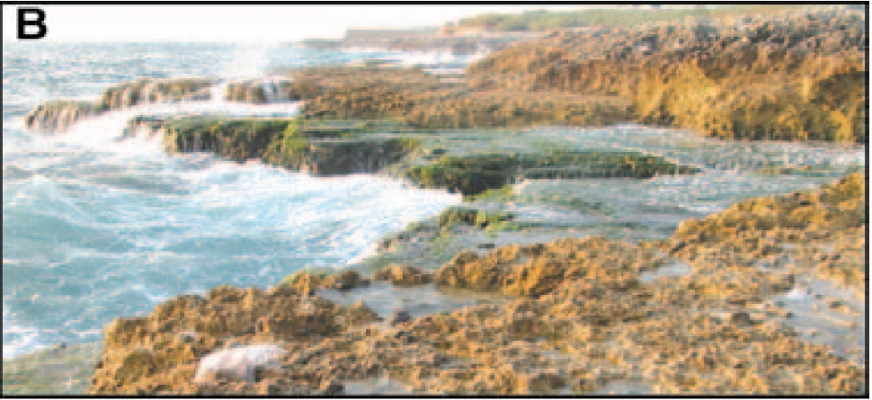 Figure 2B
Uplifted, karst-pitted vermetid benches near Tabarja
click on image to open in a new tab
Elias et al (2007)
- Fig. 1 Active faults of Lebanese
restraining bend from Elias et al. (2007)
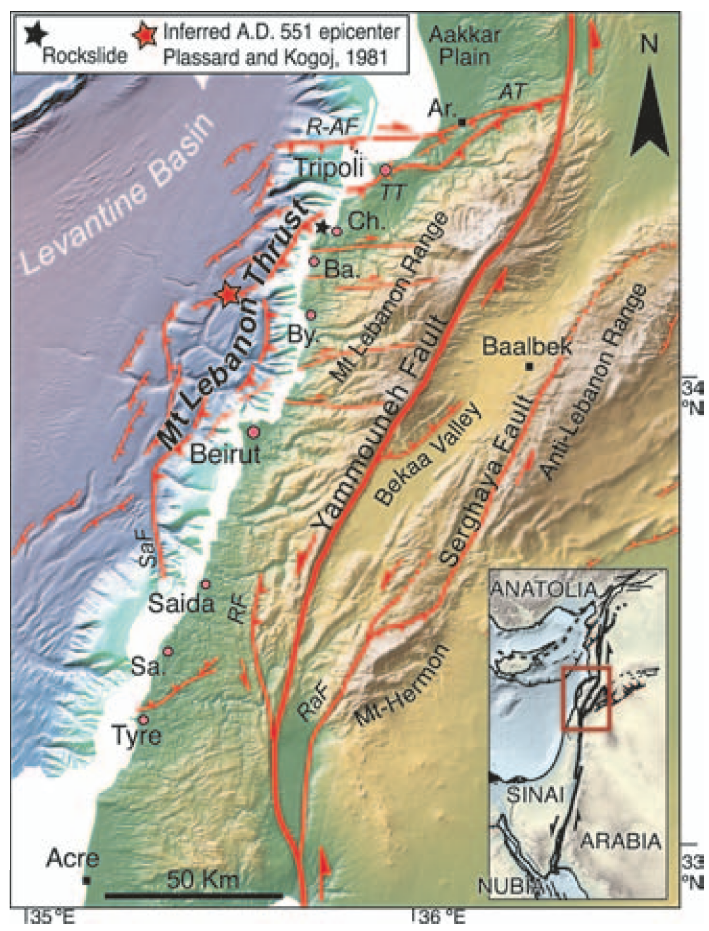 Figure 1
Active faults of Lebanese restraining bend. Map projected upon Shuttle Radar Topography Mission relief and new SHALIMAR EM300 bathymetry. Hitherto unknown thrust system (Mount Lebanon thrust) hugs continental slope base offshore Mount Lebanon. Red box in inset shows location of Lebanese bend along Levant fault system. Red circles are coastal cities that suffered Tsunami effects during the 551 A.D. event. Abbreviations:
- Ar—Arqa
- Ba—Batroun
- By—Byblos
- Ch—Chekka
- Sa—Sarafand
- AT—Aakkar thrust
- TT—Tripoli thrust
- R-AF— Rankine-Aabdeh fault
- RF—Roum fault
- RaF—Rachaya fault
- SaF—Saida fault
click on image to open in a new tab
Elias et al. (2007) - Fig. 2a Bathymetry and uplifted
vermetid samples along the Lebanese coast from Elias et al. (2007)
 Figure 2A
Left: SHALIMAR bathymetric map of the proximal Lebanese offshore. Bold red lines are "fresh" seafloor seismic breaks. Boxes a and b indicate locations of SAR images in Figure DR4 and Figure 3, respectively.
Right: 2σ calendar ages of 14C-dated "B1" vermetid samples (red dots), plotted along the coast with elevation above local mean sea level (LMSL) in cm. Most samples predate the A.D. 551 earthquake.
click on image to open in a new tab
Elias et al. (2007) - Fig. 2 Structural map of Lebanon
and relative sea-level indicators from Morhange et al. (2006)
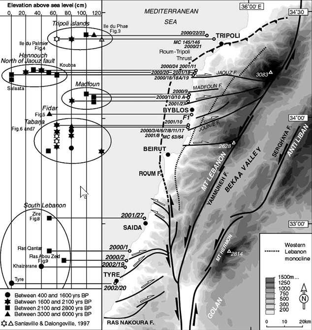 Figure 2
Structural map of Lebanon and adjacent areas.
Sample locations and their corresponding elevation above sea level are shown on the left-hand side of the figure.
click on image to open in a new tab
Morhange et al. (2006) - Fig. 4 Sources of the A.D. 551
and other major Lebanese earthquakes from Elias et al. (2007)
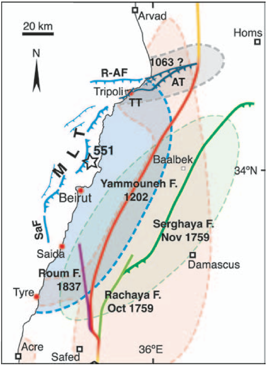 Figure 4
Most likely sources of the A.D. 551 earthquake (open star = inferred epicenter, this study) and other large historical earthquakes in Lebanon.
Modified from Daëron et al. (2005).
Colored patches enclose areas where macroseismic intensities > VIII were reported.
Blue shading corresponds to the A.D. 551 earthquake. The intensity VIII isoseismal is from Sieberg (1932).
click on image to open in a new tab
Elias et al. (2007)
- Fig. 1 Active faults of Lebanese
restraining bend from Elias et al. (2007)
Figure 1
Active faults of Lebanese restraining bend. Map projected upon Shuttle Radar Topography Mission relief and new SHALIMAR EM300 bathymetry. Hitherto unknown thrust system (Mount Lebanon thrust) hugs continental slope base offshore Mount Lebanon. Red box in inset shows location of Lebanese bend along Levant fault system. Red circles are coastal cities that suffered Tsunami effects during the 551 A.D. event. Abbreviations:
- Ar—Arqa
- Ba—Batroun
- By—Byblos
- Ch—Chekka
- Sa—Sarafand
- AT—Aakkar thrust
- TT—Tripoli thrust
- R-AF— Rankine-Aabdeh fault
- RF—Roum fault
- RaF—Rachaya fault
- SaF—Saida fault
click on image to open in a new tab
Elias et al. (2007) - Fig. 2a Bathymetry and uplifted
vermetid samples along the Lebanese coast from Elias et al. (2007)
Figure 2A
Left: SHALIMAR bathymetric map of the proximal Lebanese offshore. Bold red lines are "fresh" seafloor seismic breaks. Boxes a and b indicate locations of SAR images in Figure DR4 and Figure 3, respectively.
Right: 2σ calendar ages of 14C-dated "B1" vermetid samples (red dots), plotted along the coast with elevation above local mean sea level (LMSL) in cm. Most samples predate the A.D. 551 earthquake.
click on image to open in a new tab
Elias et al. (2007) - Fig. 2 Structural map of Lebanon
and relative sea-level indicators from Morhange et al. (2006)
Figure 2
Structural map of Lebanon and adjacent areas.
Sample locations and their corresponding elevation above sea level are shown on the left-hand side of the figure.
click on image to open in a new tab
Morhange et al. (2006) - Fig. 4 Sources of the A.D. 551
and other major Lebanese earthquakes from Elias et al. (2007)
Figure 4
Most likely sources of the A.D. 551 earthquake (open star = inferred epicenter, this study) and other large historical earthquakes in Lebanon.
Modified from Daëron et al. (2005).
Colored patches enclose areas where macroseismic intensities > VIII were reported.
Blue shading corresponds to the A.D. 551 earthquake. The intensity VIII isoseismal is from Sieberg (1932).
click on image to open in a new tab
Elias et al. (2007)
- Tabarja, Lebanon and vicinity
in Google Earth
 Tabarja, Lebanon and vicinity
click on image to explore this site on a new tab in Google Earth
- Fig. 2c Bench elevations relative
to local mean sea level from Elias et al. (2007)
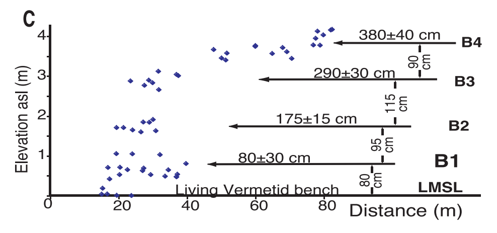 Figure 2C
Projected total station measurements of bench elevations relative to LMSL (living vermetid surface in the swash zone).
Note significant scatter in elevation measurements on fossil levels, particularly B1 and B4, likely because of sub-levels with rounded edges and irregularities produced by deep microkarst pitting.
click on image to open in a new tab
Elias et al. (2007)
- Fig. 2c Bench elevations relative
to local mean sea level from Elias et al. (2007)
Figure 2C
Projected total station measurements of bench elevations relative to LMSL (living vermetid surface in the swash zone).
Note significant scatter in elevation measurements on fossil levels, particularly B1 and B4, likely because of sub-levels with rounded edges and irregularities produced by deep microkarst pitting.
click on image to open in a new tab
Elias et al. (2007)
- Fig. 3 Seafloor seismic rupture
west of Damour from Elias et al. (2007)
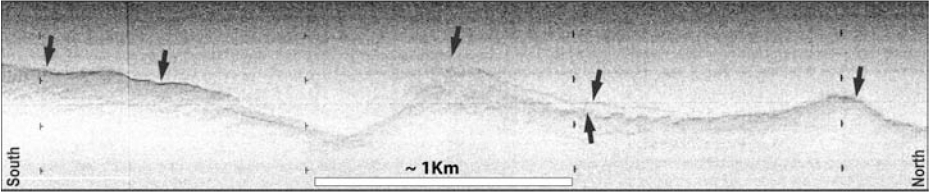 Figure 3
Seafloor seismic rupture. Sidescan sonar image of a "fresh" seismic rupture along the base of the continental slope west of Damour (box "b" in Fig. 2A). Note the sinuous, segmented trace, west-facing main scarp, and smaller parallel scarps on top of the east (hanging) wall and away from the main scarp base on the footwall. Dark shades mark high backscatter. Insonification from the top (west).
click on image to open in a new tab
Elias et al. (2007)
- Fig. 3 Seafloor seismic rupture
west of Damour from Elias et al. (2007)
Figure 3
Seafloor seismic rupture. Sidescan sonar image of a "fresh" seismic rupture along the base of the continental slope west of Damour (box "b" in Fig. 2A). Note the sinuous, segmented trace, west-facing main scarp, and smaller parallel scarps on top of the east (hanging) wall and away from the main scarp base on the footwall. Dark shades mark high backscatter. Insonification from the top (west).
click on image to open in a new tab
Elias et al. (2007)
- Fig. 2b Uplifted vermetid benches
near Tabarja from Elias et al. (2007)
 Figure 2B
Uplifted, karst-pitted vermetid benches near Tabarja.
click on image to open in a new tab
Elias et al. (2007)
- Fig. 2b Uplifted vermetid benches
near Tabarja from Elias et al. (2007)
Figure 2B
Uplifted, karst-pitted vermetid benches near Tabarja.
click on image to open in a new tab
Elias et al. (2007)
 Figure 1
Active faults of the Lebanese restraining bend. Map projected upon Shuttle Radar Topography Mission relief and new SHALIMAR EM300 bathymetry. A previously unrecognized thrust system (Mount Lebanon thrust) hugs the base of the continental slope offshore Mount Lebanon. The red box in the inset shows the location of the Lebanese restraining bend within the Levant fault system.
Red circles mark coastal cities that experienced tsunami effects during the A.D. 551 earthquake.
Abbreviations:
- Ar—Arqa
- Ba—Batroun
- By—Byblos
- Ch—Chekka
- Sa—Sarafand
- AT—Aakkar thrust
- TT—Tripoli thrust
- R-AF—Rankine-Aabdeh fault
- RF—Roum fault
- RaF—Rachaya fault
- SaF—Saida fault
click on image to open in a new tab
Elias et al. (2007)
Mount Lebanon, a ~160-km-long, ~3000-m-high transpressive coastal range emerging from the eastern Mediterranean sea, lies adjacent to the 25°-rightward restraining bend of the active Levant fault system, the left-lateral transform that constitutes the Arabia-Sinai plate boundary (Fig. 1) (e.g., Freund et al., 1970; Daëron et al., 2004). Seaward from Mount Lebanon, the Levantine margin is particularly steep, reaching water depths of ~1500 m only 8 km from shore, adjacent to the deepest part of the Levantine basin (2000 m), which is floored by thickly sedimented (~12 km) oceanic crust of Mesozoic age (Makris et al., 1983). Onland, prominent thrusts that raise and fold Plio-Quaternary marine deposits and continental conglomerates are visible along the range front NE of Chekka (Fig. 1) (Tapponnier et al., 2001; Elias et al., 2001). One such thrust cuts through the city of Tripoli (Fig. DR1 in the GSA Data Repository1), forming a ~70-m-high cumulative escarpment (Bahsas scarp). Devastating earthquakes have repeatedly shaken Lebanon and adjacent areas during the past 2000 yr (e.g., Ambraseys and Melville, 1988; Guidoboni et al., 1994). Several historical events shook coastal areas more severely than inland regions, implying source locations along the Mediterranean shore or not far to the west. That active faulting takes place offshore is suggested by recent instrumental seismicity maps (Plassard and Kogoj, 1981; Fig. DR2), but little is known of the geometry and mechanism of such faulting. Here, we present new geophysical data obtained during the 2003 SHALIMAR cruise (Briais et al., 2004) that demonstrate the existence of submarine seismogenic thrusts offshore central Lebanon. Along with recently published ages of young, uplifted wave-cut benches on the coastline (Morhange et al., 2006), the seafloor seismic breaks unambiguously define the source of the A.D. 551 earthquake, the largest event to have struck the Levant shore since Roman times. All the active faults responsible for past earthquakes in Lebanon thus now form a self-consistent tectonic framework.
Figure 1
Active faults of the Lebanese restraining bend. Map projected upon Shuttle Radar Topography Mission relief and new SHALIMAR EM300 bathymetry. A previously unrecognized thrust system (Mount Lebanon thrust) hugs the base of the continental slope offshore Mount Lebanon. The red box in the inset shows the location of the Lebanese restraining bend within the Levant fault system.
Red circles mark coastal cities that experienced tsunami effects during the A.D. 551 earthquake.
Abbreviations:
- Ar—Arqa
- Ba—Batroun
- By—Byblos
- Ch—Chekka
- Sa—Sarafand
- AT—Aakkar thrust
- TT—Tripoli thrust
- R-AF—Rankine-Aabdeh fault
- RF—Roum fault
- RaF—Rachaya fault
- SaF—Saida fault
click on image to open in a new tab
Elias et al. (2007)
Figure 2A
Left: SHALIMAR bathymetric map of the proximal Lebanese offshore. Bold red lines are "fresh" seafloor seismic breaks. Boxes a and b indicate locations of SAR images in Figure DR4 and Figure 3, respectively.
Right: 2σ calendar ages of 14C-dated "B1" vermetid samples (red dots), plotted along the coast with elevation above local mean sea level (LMSL) in cm. Most samples predate the A.D. 551 earthquake.
click on image to open in a new tab
Elias et al. (2007)
During the SHALIMAR survey, we mapped a previously unknown, east-dipping, offshore thrust system with a complex geometry, involving stepping and parallel segments, as observed along most foreland thrusts (Figs. 1 and 2). Major “range-front” ramps reach the seafloor at the base of the continental slope, where it is steepest, between Saida and Tripoli. They are offset by a ~10 km right-step west of Beirut. Farther out into the Levantine Basin, Plio-Quaternary turbidites detached above Messinian evaporites are folded to at least ~30 km from shore, where the seafloor is warped by growing anticlines above shallower, blind thrusts (Briais et al., 2004). Between these anticlines and the slope base, deep canyons incise the Jounieh plateau, which is uplifted by 150–200 m relative to the Levantine abyssal plain (Fig. 2A). The thrust system is limited to the south and north by two oblique lateral ramps: the Saida (SaF) and Rankine-Aabdeh faults (R-AF), respectively (Fig. 1). We interpret this ~160-km-long thrust system (Mount Lebanon thrust), together with the Roum fault and the Tripoli and Aakkar thrusts onland, to be responsible for the Plio-Quaternary growth of Mount Lebanon (Elias et al., 2003).
Using Ifremer’s deep-towed acoustic system (SAR), we surveyed the base of prominent, ~NE-trending, NW-sloping tectonic escarpments transverse to submarine canyons, visible on the SHALIMAR EM300 bathymetry between Enfeh and Damour (Fig. 2). The SAR images, whose pixel resolution is 25 cm, show details of spectacular submarine ruptures and scarps that cut the smoothly sediment-mantled seafloor (Figs. 2 and 3; Fig. DR4). Though segmented, these fairly continuous breaks generally follow the base of the cumulative escarpments. Most of the scarps face west, consistent with east-wall uplift, and have sinuous, stepping traces, as befits dip-slip faulting. They are often paralleled by finer breaks, suggestive of small-scale, hanging-wall collapse or footwall shortening (Fig. 3). Offshore Jounieh, the slope-base break cuts across the Nahr el Kelb submarine channel and slide-blocks within it (Fig. DR4), which suggests a young age. In the south, we could follow two of these relatively fresh, roughly parallel ruptures for 25–30 km along strike, 8–18 km from shore (Fig. 3). In the north, we could only map 5–10-km-long segments of en echelon ruptures that appear to extend over greater distances. Given their geomorphic resemblance to subaerial, seismic dip-slip ruptures, and their position near the foot of cumulative bathymetric escarpments, the seismic origin of such submarine breaks is not in doubt, although assessing whether they result from one or several earthquakes will require further investigation. Similar SAR-imaged breaks along the western stretch of the North Anatolian fault in the sea of Marmara were recently confirmed, by close-range imaging with Ifremer’s remotely operated vehicle Victor camera, to be due to one historical earthquake (1912 event) (Armijo et al., 2005).
The SHALIMAR data showed no evidence of submarine landslides except for small-scale slump scars and rockslides on or at the base of steep slopes south of Damour and near Batroun. It is thus possible to rule out the occurrence of a large local submarine landslide as potential sources of historical tsunamis along the Lebanese coast. [JW: not so fat my friend]
Elias et al. (2007) examined
uplifted benches on the Lebanese coast between Sarafand and
Tripolis, including areas near
Tabarja (~20 km NE of Beirut). They estimated
that ~80 cm of uplift occurred on the lowest bench (B1) in the
6th century CE. Deep-towed sonar data collected offshore showed
fresh west-facing fault scarps cutting across the otherwise
smooth seafloor, which they associated with seismic activity
along the newly identified offshore Mount Lebanon Thrust Fault
system. They concluded that ~100–150 km of this fault ruptured
in 551 CE, generating an earthquake with a moment magnitude
(Mw) of ~7.5.
Previous researchers had suggested that elevated fossil benches
along the Lebanese coast (mostly between Beirut and Tripolis)
were formed by past earthquake activity.
Morhange et al. (2006) used
radiocarbon dating of fossil
vermetids on the tops
of these benches to determine when they were last in the subtidal
zone (approximately mean sea level). By integrating these dates
with seismic evidence,
Elias et al. (2007) concluded
that the well-documented 551 Beirut earthquake caused 80 ± 30 cm
of uplift of the lowest bench (B1) during that seismic event.
 Figure DR7
Death age probability distribution of 17, 14C calibrated Vermetid death ages on
"B1" bench between Beirut and Palmier Island (sum probability, normalized to unit height).
Elias et al (2007) supplemental
Elias et al (2007)
discovered an ~160 km. long offshore thrust system in the process of collecting and analyzing their geophysical data. They termed this new thrust fault system the
the Mount Lebanon Thrust.
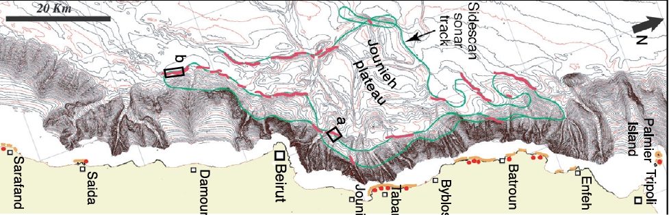 Figure 2a
Bathymetric map of proximal Lebanese offshore.
-
Offshore
- Bold red lines are "fresh" seafloor seismic breaks.
- Green line is survey path.
- Box b indicates location of sonar image in Figure 3 above.
Onshore- Orange lines are locations of elevated benches
- Red dots are sample locations for radiocarbon dating.
JW: Image is rotated compared to original publication -
Elias et al (2007)
The deep towed sonar data showed fresh west facing seismogenic fault scarps on the smooth ocean floor which allowed them to map and characterize this thrust system. In commenting on the fault scarps, they stated that
given their geomorphic resemblance to sub-aerial, seismic dip-slip ruptures, and their position near the foot of cumulative bathymetric escarpments, the seismic origin of such submarine breaks is not in doubt, although assessing whether they result from one or several earthquakes will require further investigation.
 Figure 3
Seafloor seismic rupture. Sidescan sonar image of "fresh" seismic rupture along base of continental slope west of Damour (box "b" in Fig. 2A). Note sinuous, segmented trace, west-facing main scarp, and smaller parallel scarps on top of east (hanging) wall and away from main scarp base on footwall. Dark shades mark high backscatter. Insonification from top (west).
Elias et al (2007)
They later added that "direct dating of the sea-floor scarps will provide the ultimate proof". They noted that their survey "showed no evidence of submarine landslides except for small-scale slump scars and rockslides on or at the base of steep slopes south of Damour and near Batroun" concluding that it was "possible to rule out the occurrence of a large local submarine landslide as potential sources of historical tsunamis [e.g. in 551 CE] along the Lebanese coast." This last conclusion does not seem justified given the limited amount of side scan sonar data they collected. Further, the textual sources for the 551 CE Beirut Quake spoke of an initial ebbing of the sea which suggests that the tsunami was caused by a large submarine landslide. Nonetheless, the geographic coincidence of the stretch of coast exhibiting uplifted benches with the observed areal extent of submarine fault scarps appears to confirm that the Mount Lebanon Thrust fault was the source of large ancient earthquakes and tsunamis along the coast.
Elias et al (2007) estimated a moment magnitude (Mw) of ~7.4-7.6 for the 551 CE Beirut Quake and offered the following discussion:
To raise the Tabarja trottoirs [benches] 80 ± 30 cm above the LMSL [Local Mean Sea Level], simple dislocation modeling in an elastic half-space (Okada, 1985) requires 1.5-3 m of seismic slip on these ramps, assuming they dip -45° eastward in the upper 20 km of the crust (Data Repository item DR8). Such slip amounts are consistent with the estimated magnitude of the A.D. 551 earthquake, and sufficient to account for the tsunami observed. Historical evidence combined with the extent of vermetid death in the sixth century A.D. implies a rupture length of at least -100 km, and possibly up to 150 km if the Rankine-Aabdeh lateral ramp was involved (Figs. 1 and 4), as suggested by two ages on Palmier Island (Table DR6). For such rupture lengths on thrust faults, empirical scaling laws predict an Mw of ~7.4-7.6 (Wells and Coppersmith, 1994), consistent with macroseismic estimates. Because strike-slip motion on the Yammouneh fault has been shown to produce only small local uplift (less than ~1 m in ~10,000 yr; Daeron et al., 2005), the inference that events on this fault might raise shorelines north of Beirut (Morhange et al., 2006) can be safely ruled out. The coastal 14C vermetid ages confirm that the great A.D. 1202 earthquake, for instance, produced no uplift along the Lebanese shoreline. That benches offshore Tripoli are older than the seventh century A.D. in fact excludes the possibility that any of the earthquakes of the eleventh to fourteenth century A.D. sequence, including the A.D. 1063 event, ruptured the offshore Mount Lebanon thrust system. Hence, the destruction of Tripoli and Arqa by the latter earthquake may have been caused by slip on the Aakkar and/or Tripoli thrusts (Fig. 4).
Most likely sources of A.D. 551 (open star—inferred epicenter, this study) and other large historical earthquakes in Lebanon (modifi ed from Daëron et al., 2005). Colored patches enclose areas where macroseismic intensities >VIII were reported. Blue color corresponds to A.D. 551. (VIII isoseismal from Sieberg, 1932).
Elias et al (2007)
| Effect | Location | Image(s) | Description |
|---|---|---|---|
| Coastal Uplift | Lebanese Coast Figure 2
Structural map of Lebanon and adjacent areas. Sample locations and their corresponding elevation above sea level are shown on the left-hand side of the figure Click on image to open in a new tab Morhange et al. (2006a) |
Figure 2B Uplifted, karst-pitted vermetid benches near Tabarja. Click on image to open in a new tab Elias et al (2007) 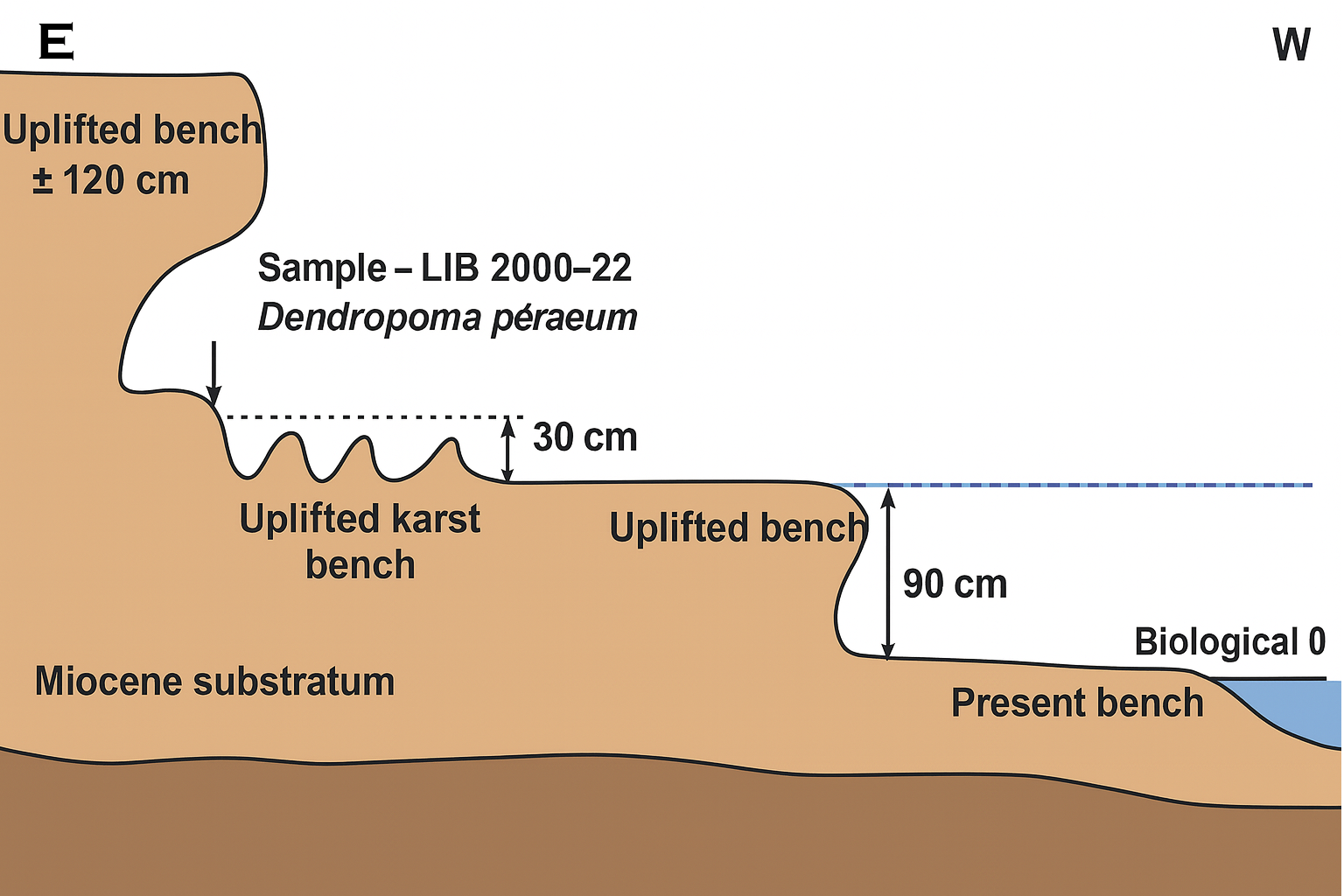 Figure 3
On the northern part of IIe du Phare (Tripoli), marks of a double raised bench have been preserved. The lowest step, at approx. +1 m (above present MSL), comprises Dendropoma dated 2630 ± 35 BP (403-265 cal. BC). The outer part of the upper step, at approx. +1.2 m, has been dissected by erosion, but on the inner part, that corresponds to the base of a tidal notch, a thin cover of in situ Dendropoma petraeum shells have been collected and dated 5975 ± 40 BP (4514-4339 cal. BC). Click on image to open in a new tab Morhange et al. (2006b) |
|
-
Earthquake Environmental
Effects (ESI 2007)
 Graphic Representation of ESI 2007 Intensity
click on image to open a higher resolution version in a new tab

| Effect | Location | Image(s) | Description | Intensity |
|---|---|---|---|---|
| Coastal Uplift | Lebanese Coast
Figure 2 Structural map of Lebanon and adjacent areas. Sample locations and their corresponding elevation above sea level are shown on the left-hand side of the figure Click on image to open in a new tab Morhange et al. (2006a) |
Figure 2B Uplifted, karst-pitted vermetid benches near Tabarja. Click on image to open in a new tab Elias et al (2007)
Figure 3On the northern part of IIe du Phare (Tripoli), marks of a double raised bench have been preserved. The lowest step, at approx. +1 m (above present MSL), comprises Dendropoma dated 2630 ± 35 BP (403-265 cal. BC). The outer part of the upper step, at approx. +1.2 m, has been dissected by erosion, but on the inner part, that corresponds to the base of a tidal notch, a thin cover of in situ Dendropoma petraeum shells have been collected and dated 5975 ± 40 BP (4514-4339 cal. BC). Click on image to open in a new tab Morhange et al. (2006b) |
|
IX |
 Figure 2C
Projected total station measurements of bench elevations relative to LMSL (living vermetid surface in swash zone). Note signifi cant scatter in elevation measurements on fossil levels, particularly B1 and B4, likely because of sub-levels with rounded edges and of irregularities due to deep pitting by microkarst.
Elias et al (2007)