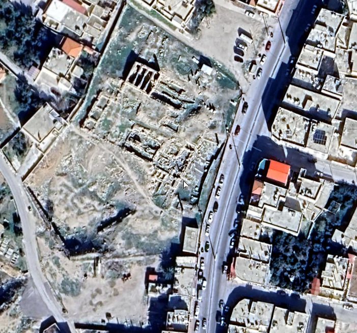
Areopolis
 Aerial View of Areopolis/Rabba
click on image to explore in Google Earth in a new tab
| Transliterated Name | Language | Name |
|---|---|---|
| Areopolis | Ancient Greek | αρεοπολισ |
| Rabba | Arabic | الربة |
| er-Rabba | Arabic | يرءراببا |
| Rabbath Moab | ||
| ir-Moab | ||
| Ma’âb | Arabic | |
| Raba |
- Fig. 10 Map of Byzantine
Palestine and Southern Syria, with provincial boundaries from Gysens (2008)
 Fig. 10
Map of Byzantine Palestine and Southern Syria, with provincial boundaries. (After Kaegi 1992).
Gysens (2008)
- Fig. 10 Map of Byzantine
Palestine and Southern Syria, with provincial boundaries from Gysens (2008)
Fig. 10
Map of Byzantine Palestine and Southern Syria, with provincial boundaries. (After Kaegi 1992).
Gysens (2008)
- Rabba/Areopolis in
Google Earth
 Rabba/Areopolis
click on image to explore this site on a new tab in Google Earth - Oblique Aerial View
of Areopolis/Rabba in Google Earth
 Rabba/Areopolis
click on image to explore this site on a new tab in Google Earth
- Fig. 173 Site Plan
from Musil (1907)
 Fig. 173
Khirbet er-Rabba Site Plan
Musil (1907) - Fig. 7 Site Plan
of archaeological west area from Gysens (2008)
 Fig. 7
The archaeological west area in scale on Musil's 1889 sketchmap of the ruins of ancient Rabbah (After Musil 1907: 370, fig. 173)
Gysens (2008) - Fig. 1 Site Plan
of the archeological site West to the modern road from Gysens (2003)
 Fig. 1
Rabba (Areopolis): plan of the archeological site West [of] the modern road (1999)
- Colonnaded Street
- Cistern
- Roman Period Temple
- Church 1
- Church 2 -
The two Greek building inscriptions dated A.D. 589/599 and 688 published by Zayadine, belonged probably to this church
- Fig. 173 Site Plan
from Musil (1907)
Fig. 173
Khirbet er-Rabba Site Plan
Musil (1907) - Fig. 7 Site Plan
of archaeological west area from Gysens (2008)
Fig. 7
The archaeological west area in scale on Musil's 1889 sketchmap of the ruins of ancient Rabbah (After Musil 1907: 370, fig. 173)
Gysens (2008) - Fig. 1 Site Plan
of the archeological site West to the modern road from Gysens (2003)
Fig. 1
Rabba (Areopolis): plan of the archeological site West [of] the modern road (1999)
- Colonnaded Street
- Cistern
- Roman Period Temple
- Church 1
- Church 2 -
The two Greek building inscriptions dated A.D. 589/599 and 688 published by Zayadine, belonged probably to this church
- from Gysens (2003)
Fig. 1Rabba (Areopolis): plan of the archeological site West [of] the modern road (1999)
- Colonnaded Street
- Cistern
- Roman Period Temple
- Church 1
- Church 2 -
The two Greek building inscriptions dated A.D. 589/599 and 688 published by Zayadine, belonged probably to this church
- Fig. 1 Church 2 Plan
from Zayadine (1971)
 Fig. 1
Zayadine (1971) - Fig. 18 Plan of central
sector including West Church from Gysens (2008)
 Fig. 18
Rabbah. Plan of the central sector. Scale 1:125
- West church with location of soundings
- South room
- Doorway into east perimeter wall
- Paved court
- Location of inscribed architrave fragment E/2004/1
- Collonaded Street [JW: not illustrated or labeled in original Figure - Collonaded Street should be to the immediate left of this Figure
(After Sabelli, Dinelli et al., 2003 with some modifications to improve clarity by JW)
Gysens (2008)
- Fig. 1 Church 2 Plan
from Zayadine (1971)
Fig. 1
Zayadine (1971) - Fig. 18 Plan of central
sector including West Church from Gysens (2008)
Fig. 18
Rabbah. Plan of the central sector. Scale 1:125
- West church with location of soundings
- South room
- Doorway into east perimeter wall
- Paved court
- Location of inscribed architrave fragment E/2004/1
- Collonaded Street [JW: not illustrated or labeled in original Figure - Collonaded Street should be to the immediate left of this Figure
(After Sabelli, Dinelli et al., 2003 with some modifications to improve clarity by JW)
Gysens (2008)
- Fig. 5 - Fragmentary Inscription
from Rucker and Niemi (2010)
 Figure 5
A dedicatory inscription found in secondary context at the ancient site of Areopolis. east of the Dead Sea, which reads: "Restored in 492 [597-598 C.E.] after the earthquake" (from Zayadine.,1971)
Rucker and Niemi (2010) - Fig. 2 - Inscription from
Zayadine (1971)
 Fig. 2
Inscription at Areopolis
Zayadine (1971)
- from Zayadine (1971)
Immediately south of the temple, we could distinguish the remains of a monument with an apse, summarily noted by Briinnow and von Domaszewski.4 Their plan was improved by R. Canova5 who sees in this monument a Byzantine church (fig. 1). It should be noted that this building is turned towards the west. R. Canova believes that this anomaly is due to the fact that this place of worship covered a Roman building which imposed on it the orientation towards the west.6 It is not clear what kind of monument of the Roman period could have stood near the temple and why this monument would be turned towards the west, while the temple itself faces towards the east.
In Jerash, when a synagogue was transformed into a church, its orientation was changed from west to east.7 It is therefore not normal for a Christian church to face west. The problem would be solved if we could prove that this curious monument is a synagogue looking toward Jerusalem, like that of Jerash. Now, in the life of Barsauma the Syrian (5th century), the author relates how the holy monk destroyed the synagogue of the Jews in Rabbat Moab, of which he gives the following description8:
When they arrived at the city called Rabbat Moab, there was there a synagogue of the Jews. No synagogue like it was built anywhere else, except only the temple (Haykla) that King Solomon built in Jerusalem. It was built of large hewn stones, the walls and the floor were inlaid with bronze, and it was studded with much gold and silver. Small golden bells were hung on all the faces of its doors. A wall of strong stones surrounded it; there were also large iron doors in this wall outside, and doors of bronze were made inside in the temple.Despite the style enhanced with legendary and fanciful details, the topographical elements do not seem to be invented.9 The monument could have been transformed into a church but it is difficult to prove, because modern dwellings cover the site. Thanks to the excavations carried out by the Department of Antiquities from 1962 to 1963, a small church located to the east of the temple was discovered (pl. III). Its apse, facing east, reaches 4.60 m and its length about 15 m. The constructions surrounding this church apparently overflowed onto the Roman road and were placed on a layer of basalt and limestone. Nothing can be presumed about their original use and their plan is difficult to read.
Musil10 had already reported another building, located in the centre of the village and which people call "keniseh". R. Canova11 is not sure that this monument is a church, but a complete clearing could certainly justify this traditional name. Let us recall that the city of Areopolis, which was part of Palestina Tertia, had an episcopal seat. It does not appear on the map of Madaba, but the mosaic of Ma'in, cleared and published by Father de Vaux,12 reproduces some constructions of the city (pl. IV): they consist of a central building, covered with a tiled roof and which ends, on the right, with a semicircle, pierced by an arched opening. Under the roof, the wall is divided into three panels, pierced by rectangular windows. On either side, stand two pavilions with tiers. The inscription is currently incomplete, but one can distinguish the end: .... OPOLEIS.
It is thanks to the work of the Department of Antiquities that our two inscriptions were discovered, but unfortunately their point of fall [discovery location] was not noted; I found them in 1968 at the home of a villager, where they had been deposited, and transported them to the museum of Kerak, recently set up in the Citadel. However, it is certain that they come from the rake between the temple and the Roman colonnade.
Inscription No. 1: (pl. V and Fig. 2)
Fig. 2Inscription at Areopolis
Zayadine (1971)
It is gray on a limestone stone 55 cm wide by 42 high, with a thickness of 28 cm. The right edge has been slightly damaged.
The four-line text begins and ends with a partially mutilated cross; we do not observe any ligature, only a few common abbreviations:
1. +'Επι' 'Ιωαννου τουTranslation
2. 'αγ(ιωτατου) επισχ(οπου) ανενε-
3. ωθη ετους Υ|Β
4. μςτα τ(ον) σισμον +
During the incumbency of most holy Bishop John [this building] has been restored in the year 492, after the earthquake.
Commentary
Line 1: Bishop John of Areopolis is mentioned, to my knowledge, for the first time. But we can name three of his predecessors; they are: Anastasius, who participated in the Council of Ephesus in 449; Polychronius and Elijah who attended the synods of Jerusalem in 518 and 536.
Line 2: "has been restored": the building which is the subject of this dedication was unfortunately not mentioned. One could suppose that it belongs to the small recently discovered church (pl. III), but nothing proves it.
Line 3: "the year 492": this is the era of the Province of Arabia, well attested for region and which begins on March 22, 105 AD. This date therefore corresponds to 597 - 598 AD.
Line 4: "after the earthquake": This last line adds to the interest of this dedication, because it is the first time that an inscription mentions an earthquake in this region.
The characters on this line have been damaged, but it is safe to read; the "tone" has been shortened and the sign you see at the end of the line is a damaged cross, as we have specified above.
It is understood that the date is that of the restoration and not that of the earthquake; nevertheless, it is safe to assume that the works were not carried out long after the disaster. Among the known earthquakes, the closest to the date mentioned is 588 AD16; but it seems to have mainly affected the city of Antioch. Another earthquake, which occurred in 599 AD17, devastated Mesopotamia. It therefore appears that the catastrophe which affected the city of Areopolis is only attested by this inscription. Moreover, this capital of Moab seems to have been devastated by several earthquakes. Hill18 believes that the depiction of Poseidon on the city's coins, minted with the effigy of Caracalla, is related to these catastrophes. The decay of the Roman temple is certainly the result of a violent earthquake, as the first travelers pointed out19.
| Effect | Location | Image (s) | Comments |
|---|---|---|---|
| Presumed collapsed walls based on rebuilding evidence | Somewhere in Areopolis
Fig. 1 Rabba (Areopolis): plan of the archeological site West [of] the modern road (1999)
|
Figure 5 A dedicatory inscription found in secondary context at the ancient site of Areopolis. east of the Dead Sea, which reads: "Restored in 492 [597-598 C.E.] after the earthquake" (from Zayadine.,1971) Rucker and Niemi (2010) |
|
-
Earthquake Archeological Effects chart
of Rodríguez-Pascua et al (2013: 221-224)
 Earthquake Archeological Effects (EAE)
Rodríguez-Pascua et al (2013: 221-224)
| Effect | Location | Image(s) | Description | Intensity |
|---|---|---|---|---|
|
Areopolis |
|
|
-
Earthquake Archeological Effects chart
of Rodríguez-Pascua et al (2013: 221-224)
Earthquake Archeological Effects (EAE)
Rodríguez-Pascua et al (2013: 221-224)
| Effect | Location | Image (s) | Comments | Intensity |
|---|---|---|---|---|
| Presumed collapsed walls based on rebuilding evidence | Somewhere in Areopolis
Fig. 1 Rabba (Areopolis): plan of the archeological site West [of] the modern road (1999)
|
Figure 5 A dedicatory inscription found in secondary context at the ancient site of Areopolis. east of the Dead Sea, which reads: "Restored in 492 [597-598 C.E.] after the earthquake" (from Zayadine.,1971) Rucker and Niemi (2010) |
|
VIII+ |