Open this page in a new tab

Deir 'Aziz

Aerial View of Deir 'Aziz Synagogue

Click on image to open a high resolution magnifiable image in a new tab

Abraham Graicer - Wikipedia - CC BY-SA 4.0


Names

Transliterated Name Source Name
Deir 'Aziz Arabic
Dir 'Aziz Arabic
Introduction
Introduction

The ruined village of Deir ‘Aziz is located 6.5 km east of the Sea of Galilee (380 m above sea level) near the Kanaf moshav. It extends over the edge of the Golan plateau down the slope of Naḥal Kanaf (Wadi Deir ‘Aziz–Wadi Samata) toward the spring of Deir ‘Aziz. Results of a surface survey indicate insignificant settlement during the Early and Middle Roman periods (first century BCE–third century CE, 8 percent of the ancient pottery) and a flourishing village in the Late Roman and Byzantine periods (fourth–eighth centuries CE, 78 percent of the pottery). The site was also occupied during the Mameluke period (thirteenth–fifteenth centuries ce) and the twentieth century.

The remains of a synagogue lie on the slope, roughly midway between the top of the ruin and the spring. This structure was first described and drawn in 1885 by L. Oliphant, who did not, at the time, identify it as a synagogue. In 1885 the eastern façade of the building remained standing to a considerable height (c. 4 m, 10–12 courses) and the undecorated eastern portal was still intact. Reuse of the structure in the 1950s as a dwelling and storage place caused considerable damage, leaving only about half the height of the east façade intact. The remainder of the building is described here in detail. It was identified as a synagogue in 1979 during a survey by Z. U. Ma‘oz on the basis of its exterior walls, several entryways facing east and west, and two interior columns visible above the sloping ground surface. At the uppermost part of the settlement are the remains of a solidly built ashlar structure (42.7 by 27.45 m), preserved to a height of three courses. Though the function of this structure is unclear, its size and plan make it unsuitable for use as a synagogue.

Excavations aimed at clearance of the synagogue and its surroundings began in 1998 and ended in 2004. The project was conducted on behalf of the Department of Land of Israel Studies at Bar-Ilan University. C. Ben David of the Jordan Valley College headed the project and Z. U. Ma‘oz served as the archaeological director.

Maps, Aerial Views, Plans, Sections, and Photos

Maps

  • Fig. 1 - Location Map from Eisenberg and Osband (2022)
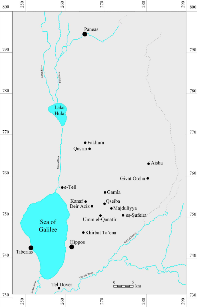
Aerial Views

  • Fig. 1 Aerial view of the site from Zingboym (2011)
  • Deir 'Aziz in Google Earth
  • Deir 'Aziz on govmap.gov.il

Plans and Sections

Area Plans and Sections

Synagogue

Normal Size

Magnified

Spring Structure

Normal Size

  • Fig. 2 Plan and sections of spring structure from Zingboym (2011)

Magnified

  • Fig. 2 Plan and sections of spring structure from Zingboym (2011)

Photos

  • Fig. 6 Shifted floor of the trough of the spring structure from Zingboym (2011)

Chronology
Phasing

Synagogue - Stern et al. (2008)

Phase Date Century CE Comments
1 mid-6th construction of prayer hall with benches, using smoothly dressed masonry preserved on the eastern façade and architectural spolia; and the narrow staircase leading to the women’s gallery. Hundreds of worn-out bronze coins, miniscule coin-like pieces, and two gold coins were collected from the hall’s foundation, indicating a construction date during the reign of Justinian.
2 late 6th renovations using masonry exhibiting a semi-fine stone dressing, as preserved on the eastern façade and the apse; construction of the Ark of the Law; partial replacement of the southern benches by perhaps a bema; burial of architectural elements, including a Greek inscription; construction of an antechamber on the eastern side of the building (although this may alternatively belong to phase 4). A hoard of 14 gold coins dating to the reign of Justinian comes from this phase.
3 749 postulated destruction by earthquake, possible indications of which are visible at the foot of the eastern façade; presumed collapse of the hall’s columns.
4 late 8th or early 9th reerection of the columns; construction of a new south wall abolishing the former apsed shrine; a new west façade with a main and side entrance; a new staircase on the interior in front of these western entrances (covering the old benches); a flagstone forecourt on the western side of the building, constructed in two stages. A building block incised with a cross in a circle and the new western entryway may indicate a Christian presence during this phase.
5 late 9th construction of a wall connecting the northern row of columns, the nave and the southern aisle probably having been left unroofed.
6 mid-20th - 1967 division of the hall in two by a north–south wall down its middle, with domestic rooms to the west and a jumble of long basalt beams (from the synagogue and other structures) to the east, salvaged for sale as lintels.
7 recent remains

363 CE earthquake

Discussion

Eisenberg and Osband (2022) suggest that Deir Aziz may have been damaged in one of the 363 CE Cyril Quakes.

References

Eisenberg and Osband (2022)

Deir 'Aziz

The site of Deir 'Aziz in the southern Golan was settled in the Roman, Byzantine, and Early Muslim periods. The synagogue's earlier phase was likely destroyed in the earthquake of 363 CE (Ahipaz 2013). Pottery found in the excavation under the synagogue foundations and in the survey suggests that the site was already settled in the 1st-2nd centuries CE and continued at least in part after the Byzantine period into the Abbasid period. An area of pottery production at the site seems to have ceased in the 4th century. The site, like Qasrin, may have been damaged in 363 CE but this did not stop the settlement.

551 CE earthquake

Discussion

Zingboym (2011) suggest that the trough of the spring structure downslope from the synagogue shifted 8 cm. to the south during an earthquake or landslide - probably due to the 551 CE Beirut Quake.

References

Zingboym (2011)

The Deir ‘Aziz site is located in the southern Golan Heights, c. 2 km east of Moshav Kanaf. The remains of the spring structure, which were massively built of ashlars, were exposed. The site is known from surveys of G. Schumacher and L. Oliphant in 1885. The site was also surveyed after 1967 (Epstein C. and Guttman S. 1972. The Survey in the Golan Heights. In M. Kochavi ed. Judaea, Samaria and the Golan: Archaeological Survey in 1967–1968. Jerusalem, pp. 280–281 [Hebrew]). The surveys revealed that except for the Mamluk period, the site was inhabited from the Roman period until the modern era (Urman D. 1995. Ancient Synagogues: Historical Analysis and Archaeological Discovery. London-New York; Ma‘oz Z.U. Ancient Synagogues in the Golan: Art and Architecture. Qatzrin, pp. 149–153 [Hebrew]; Ben-David H. 2005. The Jewish Settlement in the Golan in the Roman and Byzantine Period in Light of the Finds of the Archaeological Survey in the Lower Golan. [Golan Studies 1]. Qatzrin, pp. 169–171 [Hebrew]). A synagogue, olive presses, cemetery and what may possibly be a pottery workshop were documented in the surveys of the site. During 1998–2004, several excavation seasons were conducted in the synagogue at the site and a unique basilica structure, an apse and a magnificent bema were uncovered. Six construction phases, dating from the sixth century CE until the modern era, were identified in the building (Ma‘oz Z.U. and Ben-David C. 2006. Innovations in the Golan—The Synagogue at Deir ‘Aziz. Qadmoniot 131:25–31 [Hebrew]).

One square (3.3 × 7.0 m; Figs. 1, 2) was opened on a slope, just west of the Mē Golan building, and remains of a vault and a trough below it, built of basalt ashlars, were exposed. The vault was composed of a wall (width 7.5 m, max. preserved height 2 m; Figs. 3, 4) that was adjoined from both sides by piers, whose bottom parts were only preserved. A retaining wall of large fieldstones was built at the rear of the wall, to prevent its stones from rolling down the slope. Spring water accumulated in the trough built beneath the vault (2.5 × 7.5 m). The trough was enclosed and paved with basalt slabs, which were coated with hydraulic plaster (Fig. 5).

It was ascertained in the excavation that part of the trough shifted c. 8 cm to the south during an earthquake or landslide (Fig. 6). The structure probably collapsed in the earthquake that struck the region in 551 CE. It was also determined that one of the slabs that enclosed the trough was missing, may be because this spot incorporated a pipe or channel that conveyed water to cultivation plots or possibly to the nearby pottery workshop. In a later phase, probably after an earthquake, the trough was sealed and a floor of stones, which were taken from the collapsed vault, was placed above it (Fig. 7). The excavation of the trough, below the level of the later stone pavement (L103), revealed numerous fragments of pottery vessels that dated until the mid-sixth century CE, including bowls (Fig. 8:1–6), cooking vessels (Fig. 8:7, 8), jars (Fig. 8:9–11) and fragments of roof tiles (Fig. 8:12, 13). Based on the ceramic finds, the late floor is dated to the second half of the sixth century CE. It seems that the early phase of the floor should be dated to the second quarter of the sixth century CE and the late floor to the third quarter of the sixth century CE. The two building phases uncovered in the excavation may correspond to Phases 1 and 2 of the synagogue exposed at the site.

Studying the data from the surveys and from photographs taken in the 1970s show that another vault with a trough below it (Figs. 9–11) was originally built east of the vault exposed in the current excavation. The eastern vault and the trough beneath it were destroyed and a small pumping pool of the Golan Heights Water Association was built on the base of the trough; it did not deviate from the dimensions of the trough, except for its eastern side. A pier (width 1.8 m) was erected between the two vaults; part of it was exposed in the excavation and another part is visible today in the pump building. Originally, the spring structure probably included another vault situated to the west of the excavated one; however, it has not yet been exposed.

The spring structure exposed at the site resembles the one excavated at the Umm el-Qanatir site (Fig. 12), located c. 4 km to the east (Ben-David H, Gonen I. and Drey Y. 2007. Umm el-Kanatir. Qadmoniot 132:118–120 [Hebrew]). The spring structure at Umm el-Qanatir includes two vaults and a trough below each. It is possible that these two structures reflect a building tradition, practiced in the southern Golan Heights, where the basalt and limestone bedrocks meet. It is obvious that the construction of these massive buildings is expensive, takes time, and requires engineering knowledge and skill in hewing basalt. In both excavations the construction of the buildings was not dated; however, they were apparently used when the Jewish settlement at the site was present in the Byzantine period. In all likelihood, the two buildings were constructed in the first or second quarter of the sixth century CE.

Seismic Effects
551 CE earthquake

Effect Location Image(s) Description
Shifted Masonry Blocks  Spring Structure

Fig. 6 It was ascertained in the excavation that part of the trough shifted c. 8 cm to the south during an earthquake or landslide (Fig. 6). The structure probably collapsed in the earthquake that struck the region in 551 CE - Zingboym (2011)

Intensity Estimates
551 CE earthquake

Effect Location Image(s) Description Intensity
Shifted Masonry Blocks  Spring Structure

Fig. 6 It was ascertained in the excavation that part of the trough shifted c. 8 cm to the south during an earthquake or landslide (Fig. 6). The structure probably collapsed in the earthquake that struck the region in 551 CE - Zingboym (2011) VIII +
This archeoseismic evidence requires a minimum Intensity of VIII (8) when using the Earthquake Archeological Effects chart of Rodríguez-Pascua et al (2013: 221-224 big pdf).

Notes and Further Reading
References

Articles and Books

Ahipaz, N., 2013. Floor Foundation Coin Deposits in Byzantine-Period Synagogues. In: Hoards and Genizot as Chapters in History. Hecht Museum Catalogue 33. Haifa: Hecht Museum, University of Haifa, pp. 63-70.

Ben-David, Chaim (2007) Golan Gem - The ancient synagogue of Deir Aziz BAR Nov/Dec 2007

Ben-David, Chaim and Osband, Mechael (2020) The Byzantine and Early-Islamic periods at Deir Aziz: A methodological question of period identification between survey and excavation in Ex Oriente Lux. Studies in Honour of Jolanta Młynarczyk

Ben David, C. and Zingboym, O. (2023) "The Synagogue at Deir ʿAziz" in Ancient Synagogues Revealed: 1981-2022. ed. L. I. Levine, Z. Weiss, U. Leibner, Jerusalem, Israel Exploration Society, 2023: 148-155.

Eisenberg, M. and Osband, M. (2022) Evidence for Settlement Decline in Late 3rd–mid-4th Centuries CE in the Hippos Region and Beyond, Aram v. 34:1 & 2, 153-184

Zingboym, Oren (2011) Deir 'Aziz Final Report Hadashot Arkheologiyot v. 123

Bibliography from The Research Center of Ancient Synagogues in the Land of Israel
Bibliography from AncientSynagogues.com

Oliphant L., 1886, “New Discoveries,” in: Palestine Exploration Fund. Quarterly Statement, January 1886, pp. 77-78

– Chiat M., 1982, Handbook of Synagogue Architecture, Chico: Scholars Press, pp. 286-287

– Ilan Z., 1991, Ancient Synagogues in Israel, Tel Aviv: Ministry of Defence, pp. 81-82 (Hebrew)

– Ma’oz Z., 1995, Ancient Synagogues in the Golan, Art and Architecture, Qazrin: Golan Archaeological Museum, pp. 149-152 (Hebrew)

– Urman D., 1995, “Public Structures and Jewish Communities in the Golan Heights,” in: Urman D. & Flesher P. (eds.), Ancient Synagogues: Historical Analysis and Archaeological Discovery, Vol. 2, Leiden: Brill, pp. 541-545

– Ma’oz Z. & Ben-David C., 2003, “Deir ‘Aziz 2000-2001,” in: Hadashot Arkheologiyot, Vol. 115, pp. 10-11

– Ma’oz Z. & Ben-David C., 2006, “New Finds in the Golan: A Synagogue at Deir Aziz,” in: Qadmoniyot, Vol. 39, pp. 25-31 (Hebrew)

– Ahipaz N., 2007, “A Hoard of Byzantine Solidi from the Deir ʿAziz Synagogue,” in: Israel Numismatic Research, Vol. 2, pp. 157-165

– Ben-David C., 2007, “Golan Gem: The Ancient Synagogue of Deir Aziz,” in: Biblical Archaeology Review, Vol. 33, No. 6, pp. 44-51

– Ma’oz Z. & Ben-David C., 2008, “Deir ‘Aziz,” in: NEAEHL, Supplemental Volume, pp. 1691-1692

– Ma’oz Z., 2011, Deir Aziz and Kanaf: the Architecture of Two Ancient Synagogues, Qazrin: Archaostyle, pp. 5-54

– Spigel C., 2012, Ancient Synagogue Seating Capacities: Methodology, Analysis and Limits, Mohr Siebeck, pp. 185-188

– Ahipaz N., 2013, “Floor Foundation Coin Deposits in Byzantine-Period Synagogues,” in: Hoards and Genizot as Chapters in History, Haifa: Hecht Museum University of Haifa, pp. 63-70

– Hachlili R., 2013, Ancient Synagogues: Archaeology and Art: New Discoveries and Current Research, Leiden: Brill, pp. 111-112, 186-187, 544-545, 584, 597

– Maoz Z., 2013, “The Genizah in the Deir Aziz Synagogue on the Golan Heights,” in: Hoards and Genizot as Chapters in History, Haifa: Hecht Museum University of Haifa, pp. 70-75

– Ahipaz N., 2015, The Custom of the Ritual Burial of Coins in Synagogues, MA thesis (Hebrew)

– Ahipaz, Nili and Uzi Leibner, 2021,“Floor Deposits in Ancient Synagogues,” in: Zion, Vol. 86, No. 2, pp. 211-230 (Hebrew)

– Zingboym, O and Ben-David C., forthcoming, “Deir ‘Aziz – Ancient Synagogue,” in: Lee I Levine et al. (eds.), Ancient Synagogues Revealed, Vol. 2

Bibliography from Stern et. al. (2008)

L. Oliphant, PEQ 18 (1886), 77

G. Schumacher, The Jaulan, London 1888, 118f

Z. U. Ma‘oz, Ancient Synagogues in the Golan: Art and Architecture, Qazrin 1995, 149–153

id. & H. Ben David, ESI 111 (2000), 11*–12*

115 (2003), 10*–12*

H. Ben David, Settlements in the “Lower Golan” in the Hellenistic, Roman and Byzantine Periods (Ph.D. diss.), Ramat-Gan 1999 (Eng. abstract).