Open this page in a new tab

Dead Sea

Satellite image of Dead Sea Dead Sea in Google Earth

click on image to explore this site on a new tab in Google Earth
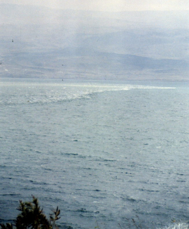

Names

Transliterated Name Source Name
The Dead Sea English
Lake of Sodom English
Lake Asphaltites English
Yam ha Melaḥ Hebrew יַם הַמֶּלַח
Yam ha Mavet Hebrew ים המוות
Yam ha Arava Hebrew ים הערבה
Ha Yam ha Kadmoni Hebrew הים הקדמוני
Āl-Baḥrū l-Maytū Arabic اَلْبَحْرُ الْمَيْتُ
Buhayrat, Bahret, or Birket Lut Arabic بحر لوط‎
Nekrá Thálassa Greek Νεκρά Θάλασσα
Asphaltítēs Greek Ἀσφαλτίτης
Asphaltítis Límnē Greek Ἀσφαλτίτις Λίμνη
Asphaltítēs Thálassa Greek Ἀσφαλτίτης Θάλασσα,
Mare Mortuum Latin
Lacus Asphaltites Latin
Introduction
Introduction

Strictly speaking a "tsunami" in an enclosed body of water such as the Dead Sea is known as a Seiche but practically speaking they are frequently referred to as tsunamis.

Aerial Views
Aerial Views

  • Dead Sea in Google Earth

Chronology
315 CE Seiche

Ambraseys (1962) and Antonopolous (1979) report a tsunami in the Dead Sea in 315 CE based on reports in difficult to find sources. Ambraseys (1962) suspects the tsunami was actually in Lake Van in Armenian Turkey in 344 or 345 CE and he is probably correct (see collapsible panel below for details). Both authors assign a Tsunami Intensity of III.

Investigation into reports of a Seiche in the Dead Sea in 315 CE

Mallet (1858:5) lists an earthquake at Areopolis on the Dead Sea citing sources von Hoff (1841:vol. ii, p. 174 ) and Ritter vol.2 p. 339. von Hoff (1841). lists an earthquake in 315 CE with the description Earthquake in Areopolis in Dead Sea [German: Erdbeben in Areopolis am Totem Meere]. von Hoff (1841) cites Ritter (1847:339) as his reference. Unfortunately, like Ambraseys(2009), I cannot find the reference by Ritter although it may be here - Ritter, K.W. (1847) "Erdbebenschreithung" vol. 2 p. 339 Breslan. Ambraseys (1962) states the following

Footnote : ' Mallet (p. 5) gives an earthquake in the Dead Sea on the authority of Ritter, which we were unable to check. The same event is described by Moses Khoren (iii, 8), but only Acogh 'ig adds that this was followed by an inundation of the sea. From Acogh'ig's narration it appears that this event occurred in the lake Van rather than in the Dead Sea. Also, this event is usually dated in 344 or 345 A.D. The translators of Armenian texts have not perceived the chronological difficulties that occur in the MSS of Moses and Acogh'ig and have committed an anachronism of exactly 30 years; cf. 116.
The historical reference appears to come from E. Dulaurier's translation of the Armenian text Acogh 'ig's universal history Publications de Ecole des Langues Orientates N.iivantes, vol. 18, p. 101-102, Paris 1898. Another copy of this book in English can be found here where the entry for the tsunami report may be on page 137.
Now when Sanatruk was king, he took possession of the city of P‘aytakaran and planned to rule the whole of Armenia.25 When the great prince Bakur realized this, who was bdeašx of Ałjnik‘, he conceived the same for himself and gave assistance to Ormizd, king of the Persians. The other nobles of Armenia assembled around the great Vrt‘anēs and dispatched two of the honourable princes to the emperor Constantius, son of Constantine,26 [asking] that he should send a force in assistance and make as king of Armenia Xosrov, son of Trdat.[66] On hearing this, he dispatched Antiochus with a huge force.27 And he came and made Xosrov king. And he sent Manačihr with his southern forces and a Cilician army[678] against Bakur the bdeašx. And Antiochus combined the other Armenian forces with his entire Greek army and moved against Sanatruk. Now he filled the city of P‘aytakaran with Persian troops and took flight to the king of Persia; he escaped with the nobles of Albania. And the Armenian forces ransacked their country and returned from there.

Now Manačihr travelled southwards; he overthrew the bdeašx Bakur and his forces and pursued those Persians who were assisting him. And he took many captives from the regions of Nisibis, including eight deacons of the great bishop Jacob; Jacob went after them and asked for these captives to be freed. And when Manačihr refused, Jacob resolved to go to the king. Antagonized by this, Manačihr ordered the eight deacons to be thrown into the lake. When the great Jacob heard this, he returned to his place angered, as Moses from the presence of Pharaoh. On reaching a certain mountain, from which the district derived, he cursed Manačihr and the district. And the judgement of God was not delayed, but Manačihr was slain soon after in the manner of Herod and the country became infertile, a sky of copper came over it and[67] the lake rebelled and extended over the boundaries of fields. When king Xosrov heard this, incensed, he ordered the captives to be freed. But after the passing of Jacob from the country, Manačihr’s son and heir, with sincere penitence, powerful tears and lamentation, through his intercession, gained healing for himself and the district.
This passage suggests that Ambraseys (1962) is correct that this supposed tsunami is likely both mis-dated and mis-located. Antonopoolos' (1979) entry reads as follows :
6. 315. Dead Sea (iii). 24 (p. 100). This indicates a tsunami intensity of 3. The reference (24, p.100) is the same one listed above by Ambraseys (1962) - STEPAN ACOGH'IG of DARON. - In E. Dulaurier's translation of the Armenian text « Acogh'is universal history ». Publications de l'Ecole des langues Orientales Vivantes, vol. 18, p. 101-102, Paris 1898.
Background Information

Stephanos Asoghik (aka Stepan Acogh 'ig) wrote Universal History in the 11th century CE and used Moses Khoren as one of his sources. Moses Khoren wrote The History of Armenia in the 5th century CE. French translations of The History of Armenia v.1 and The History of Armenia v.2 are both available online. A commentary on Moses Khoren's sources can be found here.

363 CE Seiche - Cyril Quake

No physical tsunamogenic evidence from the Cyril Quake(s) has been conclusively identified in the Dead Sea. However, as discussed in the Commentariorum In Esaiam by Jerome in the Textual Evidence for the Cyril Quakes. Jerome apparently relayed oral reports coming from the town of Areopolis of a seiche in the Dead Sea generated by the Cyril Quake(s). Although Jerome mistakenly conflated these reports with tsunamis generated in the Mediterranean during the Crete Earthquake of 365 AD, Jerome's mistake is not a reason to reject this report and Geologists would be well advised to examine the Cyril Quake seismites for tsunamogenic evidence.

749 CE Seiche - Sabbatical Year Quakes

No physical tsunamogenic evidence from the Sabbatical Year Quakes has been conclusively identified in the Dead Sea. However, Michael the Syrian and Chronicon Ad Annum 1234 both refer to a fortress in Moab inhabited by Yemenite Arabs which was moved 3 miles by a seismic sea wave. There is some ambiguity about location (the location could have been located in the Sea of Galilee) but the most probable interpretation of the text is that this took place on the eastern shores of the Dead Sea. The source for the accounts by Michael the Syrian and Chronicon Ad Annum 1234 may have been the Lost Chronicle of Theophilus of Edessa.

2004 CE Seiche

SE Mampsis Fig. 20

Waves and an unusual line in the Dead Sea, half an hour after the earthquake. Photo was taken from the Qalya coast looking eastwards

(courtesy of C. Barghoorn, Qalya).

Salamon (2005)


Maps and Photos
Maps and Photos

Normal Size

  • Fig. 1 Map of the 11 Feb. 2004 earthquake sequence from Salamon (2005)
  • Fig. 21 Ponds along the Darga coast from Salamon (2005)

Magnified

  • Fig. 1 Map of the 11 Feb. 2004 earthquake sequence from Salamon (2005)

Discussion

Amos Salamon surveyed the western shores of the Dead Sea the day after the 11 February 2004 ML = 5.2 earthquake in the northeastern Dead Sea. Salamon (2005:145) described the earthquake and seismic effects as follows:
A moderate, ML = 5.2, earthquake occurred on 11 February 2004, in the northeastern Dead Sea, at a depth of 17 km. The fault plane solution shows a transtensional mechanism with a sinistral plane that strikes NNW and a dextral plane that trends E–W. Although, in general, this mechanism accords with the nature of the Dead Sea Rift, none of the nodal planes coincides with a known structure in that area. The aftershocks were clustered west of the main shock, along a WNW direction, suggesting the right lateral plane as the preferred rupture plane. If so, this may reflect the seismogenic activity of an intra-basinal structure.

The earthquake induced a wealth of ground effects. Exploration of the northwestern Dead Sea coast immediately after the event revealed various phenomena as far as 40 km away from the epicenter, mostly in the soft Holocene deposits: cracks and landslides of different types, a few minor liquefaction occurrences, a tsunami up to a meter high and a rough sea, change of water levels in some wells and in a few sinkholes, and a change in the daily pattern of radon concentration 14 h before the earthquake. Other effects were dust, loud noise, wavy motion of the ground, and shaking palm trees.

Of all units, the Holocene Ze’elim Formation was the most severely affected. It therefore seems to be the weakest geotechnical unit in the region and thus the most vulnerable. Most of the failure effects tend to fade away and become indistinguishable and hence should be detected immediately after the earthquake
Salamon (2005:161) wrote the following about a seiche that appears to have followed the earthquake
Locals at the Qalya coast reported a wave (a run-up?) of up to a meter high and a rough sea in the northern part of the Dead Sea soon after the earthquake. A photograph taken half an hour after the earthquake (courtesy of C. Barghoorn, Qalya) shows a wavy sea near the Qalya shore and also an unusual line in the sea that may have formed just after the earthquake (Fig. 20). Residents at En Gedi, however, did not notice any unusual wave in the sea.

In the afternoon of that day and the day after, we noticed some water ponds, located a few meters inland along the Qalya and the Darga coasts (Fig. 21). In a few places along these coasts, we observed some pebbles lying on top of the washed soft rocks that form the sea shore. Since the sea was nearly flat in the morning and the afternoon of that day, we may presume that the ponds and the pebbles were emplaced by the runup wave of the tsunami.

Notes and Further Reading
References
Wikipedia Pages

Dead Sea