Petra - Blue Chapel & Ridge Church
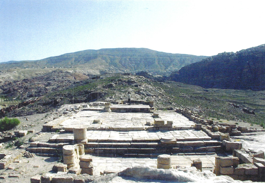
 Ridge Church (left)
Figure 3.54
View of the Ridge Church to the east with the Phase III floors; photo by Neal Bierling, Phoenix Data Systems
Bikai et al (2020)
Restored Blue Chapel (right)
Figure 2.89
View to the southeast; photo by Neil Bierling
Bikai et al (2020)
- Fig. 2 - Location Map
from Jones (2021)
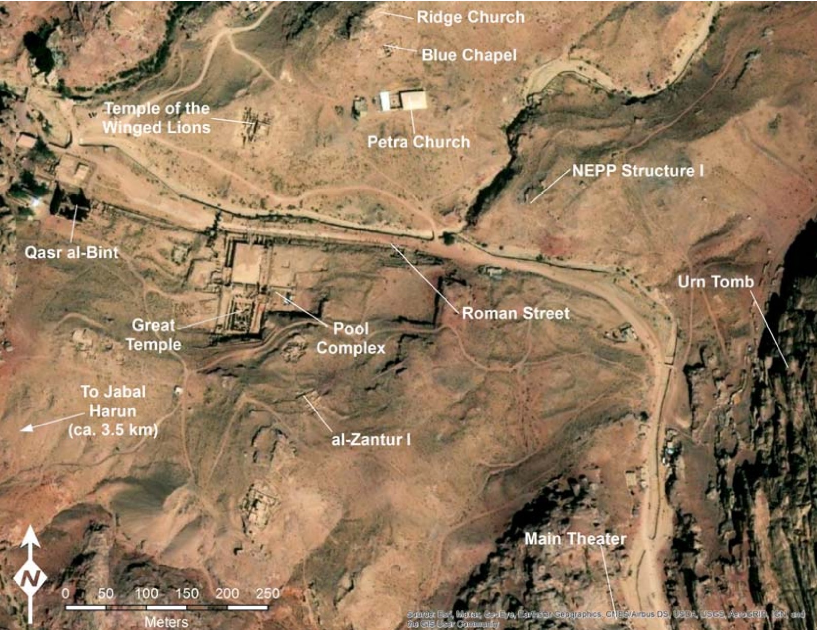 Figure 2
Map of Petra with the locations of major excavations marked
Jones (2021)
Basemap: Esri, Maxar, Earthstar Geographics, USDA FSA, USGS, Aerogrid, IGN, IGP, and the GIS User Community
- The 3 churches in Google Earth
 The 3 churches in Google Earth
- Ridge Church on the right
- Blue Chapel in the middle
- Petra Church on the left
click on image to explore this site on a new tab in Google Earth
- Fig. 1.1 - Plan of the
3 churches from Bikai et. al. (2020)
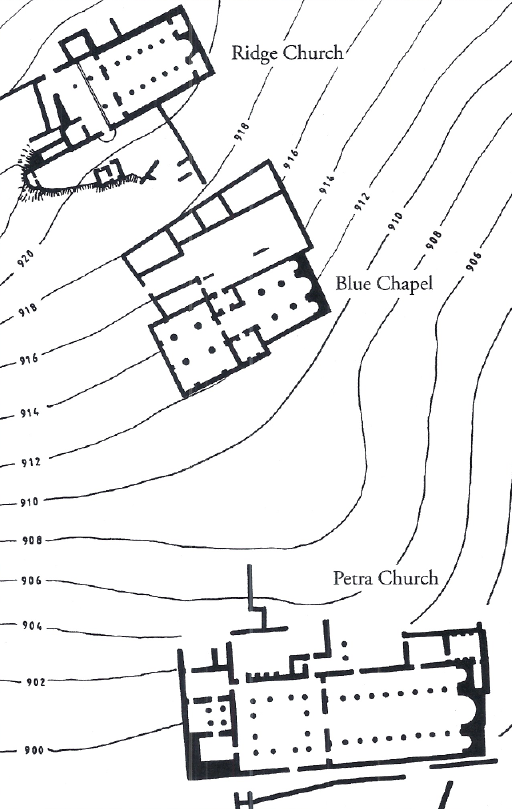 Figure 1.1
Map of the project area courtesy of Talal Akasheh, Hashemite University, Chusanthos Kanellopoulos, and American Center of Oriental Research, Amman
Bikai et al (2020) - Fig. 2.1 - Plan of
Ridge Church and Blue Chapel from Bikai et. al. (2020)
 Figure 2.1
Area designations; Ridge Church to the north and the Courtyard and Blue Chapel to the south
Bikai et al (2020) - Fig. 3.1 - Wall and
feature locus numbers of Ridge Church and Blue Chapel from Bikai et. al. (2020)
 Figure 3.1
Wall and feature locus numbers; Ridge Church to the north and the Courtyard and Blue Chapel to the south
Bikai et al (2020)
- Fig. 1.1 - Plan of the
3 churches from Bikai et. al. (2020)
Figure 1.1
Map of the project area courtesy of Talal Akasheh, Hashemite University, Chusanthos Kanellopoulos, and American Center of Oriental Research, Amman
Bikai et al (2020) - Fig. 2.1 - Plan of
Ridge Church and Blue Chapel from Bikai et. al. (2020)
Figure 2.1
Area designations; Ridge Church to the north and the Courtyard and Blue Chapel to the south
Bikai et al (2020) - Fig. 3.1 - Wall and
feature locus numbers of Ridge Church and Blue Chapel from Bikai et. al. (2020)
Figure 3.1
Wall and feature locus numbers; Ridge Church to the north and the Courtyard and Blue Chapel to the south
Bikai et al (2020)
- Fig. 3.3 - Plan of
Phase I from Bikai et. al. (2020)
 Figure 3.3
Plan of Phase I; area designations
Bikai et al (2020) - Fig. 3.28 - Plan of
Phase IIA from Bikai et. al. (2020)
 Figure 3.28
Plan of Phase IIA
Bikai et al (2020) - Fig. 3.30 - Plan of
Phase IIB from Bikai et. al. (2020)
 Figure 3.30
Plan of Phase IIB; the Ridge Church to the north and the Blue Chapel to the south
Bikai et al (2020) - Fig. 3.48 - Plan of
Phase III from Bikai et. al. (2020)
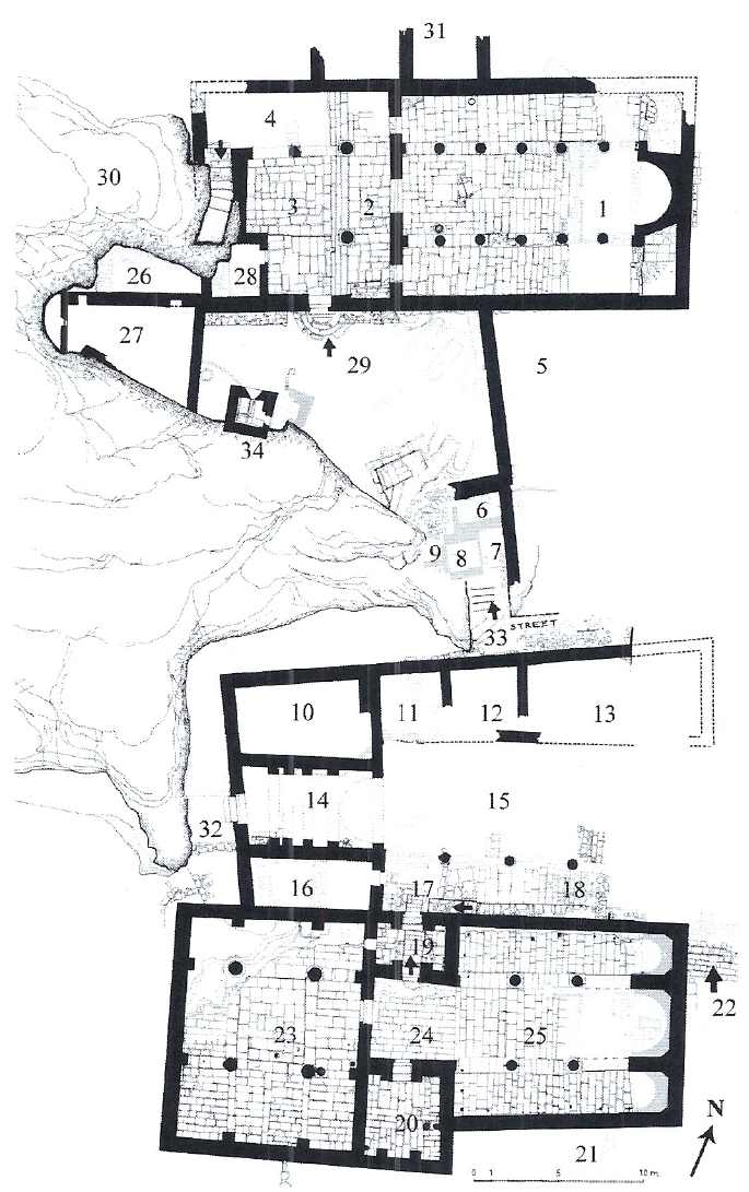 Figure 3.48
Plan of Phase III
Bikai et al (2020) - Fig. 3.102 - Plan of
Phase IV from Bikai et. al. (2020)
 Figure 3.102
Phase IV Plan
Bikai et al (2020) - Fig. 3.121 - Architecture
from Phase V Subphase 1 from Bikai et. al. (2020)
 Figure 3.121
Architecture from Phase V; Subphase 1
Bikai et al (2020) - Fig. 3.123 - Architecture
from Phase V Subphase 2 from Bikai et. al. (2020)
 Figure 3.123
Architecture from Phase V; Subphase 2
Bikai et al (2020) - Fig. 3.137 - Architecture
from Phase V Subphase 3 from Bikai et. al. (2020)
 Figure 3.137
Architecture from Phase V; Subphase 3
Bikai et al (2020) - Fig. 3.147 - Architecture
from Phase VI from Bikai et. al. (2020)
 Figure 3.147
Architecture from Phase VI
Bikai et al (2020)
- Fig. 3.3 - Plan of
Phase I from Bikai et. al. (2020)
Figure 3.3
Plan of Phase I; area designations
Bikai et al (2020) - Fig. 3.28 - Plan of
Phase IIA from Bikai et. al. (2020)
Figure 3.28
Plan of Phase IIA
Bikai et al (2020) - Fig. 3.30 - Plan of
Phase IIB from Bikai et. al. (2020)
Figure 3.30
Plan of Phase IIB; the Ridge Church to the north and the Blue Chapel to the south
Bikai et al (2020) - Fig. 3.48 - Plan of
Phase III from Bikai et. al. (2020)
Figure 3.48
Plan of Phase III
Bikai et al (2020) - Fig. 3.102 - Plan of
Phase IV from Bikai et. al. (2020)
Figure 3.102
Phase IV Plan
Bikai et al (2020) - Fig. 3.121 - Architecture
from Phase V Subphase 1 from Bikai et. al. (2020)
Figure 3.121
Architecture from Phase V; Subphase 1
Bikai et al (2020) - Fig. 3.123 - Architecture
from Phase V Subphase 2 from Bikai et. al. (2020)
Figure 3.123
Architecture from Phase V; Subphase 2
Bikai et al (2020) - Fig. 3.137 - Architecture
from Phase V Subphase 3 from Bikai et. al. (2020)
Figure 3.137
Architecture from Phase V; Subphase 3
Bikai et al (2020) - Fig. 3.147 - Architecture
from Phase VI from Bikai et. al. (2020)
Figure 3.147
Architecture from Phase VI
Bikai et al (2020)
- from Bikai et. al. (2020)
| Phase | Period | Dates | Plans | Figures/Photos | Discussion |
|---|---|---|---|---|---|
| I | Nabatean | 1st century BCE to 1st century CE | Fig. 3.3
Figure 3.3 Plan of Phase I; area designations Bikai et al (2020) |
|
|
| II | Late Roman | 1st to mid 4th century CE | Fig. 3.28
Figure 3.28 Plan of Phase IIA Bikai et al (2020) Fig. 3.30
Figure 3.30Plan of Phase IIB; the Ridge Church to the north and the Blue Chapel to the south Bikai et al (2020) |
|
|
| III | Early Byzantine |
Fig. 3.48
Figure 3.48 Plan of Phase III Bikai et al (2020) |
|
||
| IV | Late Byzantine | mid 5th - 6th centuries | Fig. 3.102
Figure 3.102 Phase IV Plan Bikai et al (2020) |
|
|
| V-1 | Early Islamic Subphase 1 |
6th - 8th centuries CE |
Fig. 3.121
Figure 3.121 Architecture from Phase V; Subphase 1 Bikai et al (2020) |
|
|
| V-2 | Early Islamic Subphase 2 |
6th - 8th centuries CE |
Fig. 3.123
Figure 3.123 Architecture from Phase V; Subphase 2 Bikai et al (2020) |
Fig. 3.134  Figure 3.134
Overall view of the ashy Phase VI, Subphase 2 occupation layer in Blue Chapel during excavation Bikai et al (2020) Fig. 3.135  Figure 3.135
Ash layer under fallen column drum 6; below are fragments of the ambo and part of a chancel post (Chapter 5: nos. 15-16) Bikai et al (2020) Fig. 3.136  Figure 3.136
Locus 1148, under column 2 Bikai et al (2020) Fig. 3.122  Figure 3.122
North section of collapse and debris in the Blue Chapel (building 2, probes 5 and 7) Bikai et al (2020) |
|
| V-3 | Early Islamic Subphase 3 |
6th - 8th centuries CE [JW: and maybe later] |
Fig. 3.137
Figure 3.137 Architecture from Phase V, Subphase 3 Bikai et al (2020) |
Fig. 3.139  Figure 3.139
Earthquake debris in area 18 Bikai et al (2020) Fig. 3.138  Figure 3.138
Area 33 with street material up to and over wall 909; north to the left Bikai et al (2020) Fig. 3.141  Figure 3.141
Earthquake collapse of cornice and vault stones in area 24 Bikai et al (2020) Fig.3.142  Figure 3.142
The vault stones in area 24 were repurposed decorative limestone architectural elements. The side exposed in the photo would have been hidden as they served as the back side of the vault stones. The undersides of the stones were smoothed in a curvilinear fashion. Bikai et al (2020) Fig. 3.143a  Figure 3.143
Overview of fallen columns in the Blue Chapel during excavation; view to the west Bikai et al (2020) Fig. 3.143b  Figure 3.143
Overview of fallen columns in the Blue Chapel during excavation; view to the east Bikai et al (2020) Fig. 3.144a  Figure 3.144
Damage to the bema floor in the Blue Chapel due to the collapse of column drum 3, the topmost drum of the northeast column; view to the east Bikai et al (2020) Fig. 3.144b  Figure 3.144
Damage to the bema floor in the Blue Chapel due to the collapse of column drum 3, the topmost drum of the northeast column; view to the south Bikai et al (2020) Fig. 3.145  Figure 3.145
Drum 2 with percussion fractures around its edge, caused by the column drums rocking during an earthquake Bikai et al (2020) Fig. 3.146  Figure 3.146
Column drum 9 and the northwest base Bikai et al (2020) |
|
| VI | Late Islamic to Modern | post 8th century CE |
Fig. 3.147
Figure 3.147 Architecture from Phase VI Bikai et al (2020) |
|
- Fig. 3.1 - Wall and feature locus numbers
of Ridge Church and Blue Chapel from Bikai et. al. (2020)
Figure 3.1
Wall and feature locus numbers; Ridge Church to the north and the Courtyard and Blue Chapel to the south
Bikai et al (2020) - Fig. 3.123 - Architecture from Phase V;
Subphase 2 from Bikai et. al. (2020)
Figure 3.123
Architecture from Phase V; Subphase 2
Bikai et al (2020) - Fig. 3.137 - Architecture from Phase V;
Subphase 3 from Bikai et. al. (2020)
Figure 3.137
Architecture from Phase V; Subphase 3
Bikai et al (2020) - Fig. 3.136 - Fallen column
underneath which an animal bone provided a 14C date - from Bikai et. al. (2020)
Figure 3.136
Locus 1148, under column 2
Bikai et al (2020) - Fig. 3.140 - Rock tumble
from Bikai et. al. (2020)
 Figure 3.140
Rock tumble in area 24; view to the north from area 19; the lintel of door 1073 is visible just above center
Bikai et al (2020) - Fig. 3.141 - Earthquake collapse of
cornice and vault stones from Bikai et. al. (2020)
Figure 3.141
Earthquake collapse of cornice and vault stones in area 24
Bikai et al (2020) - Fig. 3.142 - Vault stones re-used
as building elements from Bikai et. al. (2020)
Figure 3.142
The vault stones in area 24 were repurposed decorative limestone architectural elements. The side exposed in the photo would have been hidden as they served as the back side of the vault stones. The undersides of the stones were smoothed in a curvilinear fashion.
Bikai et al (2020) - Fig. 3.143a - Fallen Columns
from Bikai et. al. (2020)
Figure 3.143
Overview of fallen columns in the Blue Chapel during excavation; view to the west
Bikai et al (2020) - Fig. 3.143b - Fallen Columns
from Bikai et. al. (2020)
Figure 3.143
Overview of fallen columns in the Blue Chapel during excavation; view to the east
Bikai et al (2020) - Fig. 3.144a - Punctured Floor
from Bikai et. al. (2020)
Figure 3.144
Damage to the bema floor in the Blue Chapel due to the collapse of column drum 3, the topmost drum of the northeast column; view to the east
Bikai et al (2020) - Fig. 3.144b - Punctured Floor
from Bikai et. al. (2020)
Figure 3.144
Damage to the bema floor in the Blue Chapel due to the collapse of column drum 3, the topmost drum of the northeast column; view to the south
Bikai et al (2020) - Fig. 3.145 - Percussion fractures
on a column drum from Bikai et. al. (2020)
Figure 3.145
Drum 2 with percussion fractures around its edge, caused by the column drums rocking during an earthquake
Bikai et al (2020) - Fig. 3.146 - Chipped column
base from Bikai et. al. (2020)
Figure 3.146
Column drum 9 and the northwest base
Bikai et al (2020)
- Fig. 3.1 - Wall and feature locus numbers
of Ridge Church and Blue Chapel from Bikai et. al. (2020)
Figure 3.1
Wall and feature locus numbers; Ridge Church to the north and the Courtyard and Blue Chapel to the south
Bikai et al (2020) - Fig. 3.137 - Architecture from Phase V;
Subphase 3 from Bikai et. al. (2020)
Figure 3.137
Architecture from Phase V; Subphase 3
Bikai et al (2020) - Fig. 3.139 - Section showing earthquake
debris in area 18 from Bikai et. al. (2020)
Figure 3.139
Earthquake debris in area 18
Bikai et al (2020)
| Effect | Location | Image(s) | Description(s) |
|---|---|---|---|
| Collapse and Debris | Blue Chapel Building 2 Area 25 Probes 5&7
Figure 3.121Architecture from Phase V; Subphase 1 Bikai et al (2020)
Figure 3.1Wall and feature locus numbers; Ridge Church to the north and the Courtyard and Blue Chapel to the south Bikai et al (2020) |
Fig. 3.122
Figure 3.122 North section of collapse and debris in the Blue Chapel (building 2, probes 5 and 7) Bikai et al (2020) |
|
- Archaeoseismic evidence all comes from the Blue Chapel (Lower Sector Building 2)
| Effect | Location | Image(s) | Description(s) |
|---|---|---|---|
| Fallen Column | Area 25
Figure 3.137 Architecture from Phase V; Subphase 3 Bikai et al (2020)
Figure 3.1Wall and feature locus numbers; Ridge Church to the north and the Courtyard and Blue Chapel to the south Bikai et al (2020) |
Figure 3.136 Locus 1148, under column 2 Bikai et al (2020) |
a fallen column (drum no. 2) |
| Fallen Columns | Area 25
Figure 3.137 Architecture from Phase V; Subphase 3 Bikai et al (2020)
Figure 3.1Wall and feature locus numbers; Ridge Church to the north and the Courtyard and Blue Chapel to the south Bikai et al (2020) |
View to the West
Figure 3.143 Overview of fallen columns in the Blue Chapel during excavation; view to the west Bikai et al (2020) View to the East
Figure 3.143Overview of fallen columns in the Blue Chapel during excavation; view to the east Bikai et al (2020) |
|
| Orientation and identification of Fallen Columns | Area 25
Figure 3.137 Architecture from Phase V; Subphase 3 Bikai et al (2020)
Figure 3.1Wall and feature locus numbers; Ridge Church to the north and the Courtyard and Blue Chapel to the south Bikai et al (2020) |
 Figure 4.46
Plan of the proper as excavated, showing the fallen columns, the holes in the floor for the benches, and the holes for the altar posts; drawing by Patricia M Bikai Bikai et al (2020) |
Drawing shows orientation of Fallen Columns in the Blue Chapel as well as their numerical identification (1-11) |
| Percussion Fractures on Column Drum | Area 25
Figure 3.137 Architecture from Phase V; Subphase 3 Bikai et al (2020)
Figure 3.1Wall and feature locus numbers; Ridge Church to the north and the Courtyard and Blue Chapel to the south Bikai et al (2020) |
Figure 3.145 Drum 2 with percussion fractures around its edge, caused by the column drums rocking during an earthquake Bikai et al (2020) |
Drum 2 with percussion fractures around its edge, caused by the column drums rocking during an earthquake- Bikai et al (2020) |
| Fractured Column Drum | Area 25
Figure 3.137 Architecture from Phase V; Subphase 3 Bikai et al (2020)
Figure 3.1Wall and feature locus numbers; Ridge Church to the north and the Courtyard and Blue Chapel to the south Bikai et al (2020) |
Figure 3.146 Column drum 9 and the northwest base Bikai et al (2020) |
Column drum 9 and the northwest base |
| Damage to the Bema Floor | Area 25
Figure 3.137 Architecture from Phase V; Subphase 3 Bikai et al (2020)
Figure 3.1Wall and feature locus numbers; Ridge Church to the north and the Courtyard and Blue Chapel to the south Bikai et al (2020) |
View to the East
Figure 3.144 Damage to the bema floor in the Blue Chapel due to the collapse of column drum 3, the topmost drum of the northeast column; view to the east Bikai et al (2020) View to the South
Figure 3.144Damage to the bema floor in the Blue Chapel due to the collapse of column drum 3, the topmost drum of the northeast column; left, view to the south Bikai et al (2020) |
thought to be caused by fall of column drum 3 |
| Rock Tumble | Area 24
Figure 3.137 Architecture from Phase V; Subphase 3 Bikai et al (2020)
Figure 3.1Wall and feature locus numbers; Ridge Church to the north and the Courtyard and Blue Chapel to the south Bikai et al (2020) |
Figure 3.140 Rock tumble in area 24; view to the north from area 19; the lintel of door 1073 is visible just above center Bikai et al (2020) |
includes fallen door lintel |
| Collapse of cornice and vault stones with courses preserved | Area 24
Figure 3.137 Architecture from Phase V; Subphase 3 Bikai et al (2020)
Figure 3.1Wall and feature locus numbers; Ridge Church to the north and the Courtyard and Blue Chapel to the south Bikai et al (2020) |
Figure 3.141 Earthquake collapse of cornice and vault stones in area 24 Bikai et al (2020) |
along the western and northern walls of the entry hall |
| Re-used Building elements | Area 24
Figure 3.137 Architecture from Phase V; Subphase 3 Bikai et al (2020)
Figure 3.1Wall and feature locus numbers; Ridge Church to the north and the Courtyard and Blue Chapel to the south Bikai et al (2020) |
Figure 3.142 The vault stones in area 24 were repurposed decorative limestone architectural elements. The side exposed in the photo would have been hidden as they served as the back side of the vault stones. The undersides of the stones were smoothed in a curvilinear fashion. Bikai et al (2020) |
along the western and northern walls of the entry hall. Bikai et al (2020) suggested that these re-used building elements were taken from the collapse of the vault. |
| Second Storey Collapse | Area 20
Figure 3.137 Architecture from Phase V; Subphase 3 Bikai et al (2020)
Figure 3.1Wall and feature locus numbers; Ridge Church to the north and the Courtyard and Blue Chapel to the south Bikai et al (2020) |
clear evidence for collapse of the second story was discovered within area 20. A number of floor slabs probably from the upper floor were noted ca. 0.50 m from the room's floor level in loci 973, 1177, and the upper levels of 1030.- Perry in Bikai et al (2020:70) |
|
| Thick (1-1.5 m) layers of building tumble | Stairway in Area 19
Figure 3.137 Architecture from Phase V; Subphase 3 Bikai et al (2020)
Figure 3.1Wall and feature locus numbers; Ridge Church to the north and the Courtyard and Blue Chapel to the south Bikai et al (2020) |
loci 1052, 1057, 1071, and the upper levels of 1114, and 1115 | |
| Thick (1-1.5 m) layers of building tumble | entry hall in area 24
Figure 3.137 Architecture from Phase V; Subphase 3 Bikai et al (2020)
Figure 3.1Wall and feature locus numbers; Ridge Church to the north and the Courtyard and Blue Chapel to the south Bikai et al (2020) |
loci 1109 and the upper levels of 1130 | |
| Thick (1-1.5 m) layers of building tumble | Area 20
Figure 3.137 Architecture from Phase V; Subphase 3 Bikai et al (2020)
Figure 3.1Wall and feature locus numbers; Ridge Church to the north and the Courtyard and Blue Chapel to the south Bikai et al (2020) |
loci 973, 1027, and 1177 | |
| Thick (1-1.5 m) layers of building tumble | Area 23 the atrium
Figure 3.137Architecture from Phase V; Subphase 3 Bikai et al (2020)
Figure 3.1Wall and feature locus numbers; Ridge Church to the north and the Courtyard and Blue Chapel to the south Bikai et al (2020) |
lower level of loci 1037 and 1125 and loci 1039, 1041, 1140, 1145, and 1165 in the southern half of the room, the middle levels of locus 1132 and loci 1173, 1176, 1189, 1190, 1201, 1207, 1220, 1225, and 1228 in the northern half of the room | |
| Thick (1-1.5 m) layers of building tumble | Area 25
Figure 3.137 Architecture from Phase V; Subphase 3 Bikai et al (2020)
Figure 3.1Wall and feature locus numbers; Ridge Church to the north and the Courtyard and Blue Chapel to the south Bikai et al (2020) |
upper levels of loci 1048, 1050, and 1087 and loci 1062, 1063, and 1088 in the central aisle, the upper levels of locus 1087 and loci 1088, 1103, and 1153 in the northern aisle, loci 1087, 1088, and 1147 in the southern aisle, and locus 1088 in the bema |
| Effect | Location | Image(s) | Description(s) |
|---|---|---|---|
| Earthquake debris due to collapsed walls | Blue Chapel Building 1 Areas 11, 14, 15, 17, and 18
Figure 3.147Architecture from Phase VI Bikai et al (2020)
Figure 3.1Wall and feature locus numbers; Ridge Church to the north and the Courtyard and Blue Chapel to the south Bikai et al (2020) |
Figure 3.139 Earthquake debris in area 18 Bikai et al (2020) |
|
- Modified by JW from Fig. 3.137 of Bikai et al (2020)
 Deformation Map
modified by JW from Fig. 3.137 (Phase V-3 plan) of Bikai et al (2020)
- Earthquake Archeological Effects chart
of Rodríguez-Pascua et al (2013: 221-224)
 Earthquake Archeological Effects (EAE)
Rodríguez-Pascua et al (2013: 221-224)
| Effect | Location | Image(s) | Description(s) | Intensity |
|---|---|---|---|---|
| Collapse and Debris | Blue Chapel Building 2 Area 25 Probes 5&7
Figure 3.121Architecture from Phase V; Subphase 1 Bikai et al (2020)
Figure 3.1Wall and feature locus numbers; Ridge Church to the north and the Courtyard and Blue Chapel to the south Bikai et al (2020) |
Fig. 3.122
Figure 3.122 North section of collapse and debris in the Blue Chapel (building 2, probes 5 and 7) Bikai et al (2020) |
|
VIII + |
-
Earthquake Archeological Effects chart
of Rodríguez-Pascua et al (2013: 221-224)
Earthquake Archeological Effects (EAE)
Rodríguez-Pascua et al (2013: 221-224)
| Effect | Location | Description | Intensity |
|---|---|---|---|
| Fallen Columns | Blue Chapel Area 25
Figure 3.137Architecture from Phase V; Subphase 3 Bikai et al (2020)
Figure 3.1Wall and feature locus numbers; Ridge Church to the north and the Courtyard and Blue Chapel to the south Bikai et al (2020) |
|
VI + |
| Collapsed Vault | Blue Chapel Area 24
Figure 3.137Architecture from Phase V; Subphase 3 Bikai et al (2020)
Figure 3.1Wall and feature locus numbers; Ridge Church to the north and the Courtyard and Blue Chapel to the south Bikai et al (2020) |
|
VIII + |
| Collapsed Walls | Blue Chapel Area 20
Figure 3.137Architecture from Phase V; Subphase 3 Bikai et al (2020)
Figure 3.1Wall and feature locus numbers; Ridge Church to the north and the Courtyard and Blue Chapel to the south Bikai et al (2020) |
|
VIII + |
-
Earthquake Archeological Effects chart
of Rodríguez-Pascua et al (2013: 221-224)
Earthquake Archeological Effects (EAE)
Rodríguez-Pascua et al (2013: 221-224)
| Effect | Location | Image(s) | Description(s) | Intensity |
|---|---|---|---|---|
| Earthquake debris due to collapsed walls | Blue Chapel Building 1 Areas 11, 14, 15, 17, and 18
Figure 3.147Architecture from Phase VI Bikai et al (2020)
Figure 3.1Wall and feature locus numbers; Ridge Church to the north and the Courtyard and Blue Chapel to the south Bikai et al (2020) |
Figure 3.139 Earthquake debris in area 18 Bikai et al (2020) |
|
VIII+ |