Petra - Introduction
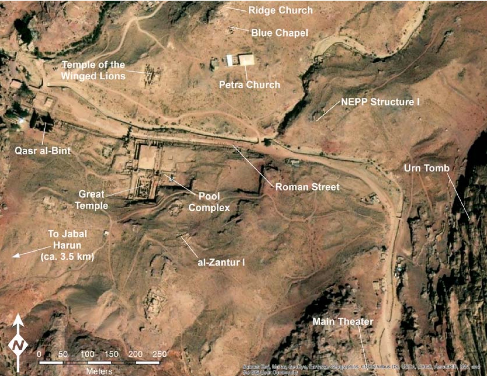 Figure 2
Map of Petra with the locations of major excavations marked
Jones (2021)
Basemap: Esri, Maxar, Earthstar Geographics, USDA FSA, USGS, Aerogrid, IGN, IGP, and the GIS User Community
| Transliterated Name | Language | Name |
|---|---|---|
| Petra | English | |
| Al-Batrā | Arabic | ٱلْبَتْرَاء |
| Petra | Ancient Greek | Πέτρα |
| Rekeme | Thamudic ? | |
| Raqmu | Arabic | |
| Raqēmō | Arabic | |
| Rekem | ||
| Edom |
Petra is traditionally accessed through a slot canyon known as the Siq. The site was initially inhabited at least as early as the Neolithic and has been settled sporadically ever since - for example in the Biblical Edomite, Hellenistic, Nabatean, Byzantine, and Crusader periods. After the Islamic conquest in the 7th century CE, Petra lost its strategic and commercial value and began to decline until it was "re-discovered" by the Swiss explorer Johann Ludwig Burckhardt in 1812 (Meyers et al, 1997). It is currently a UNESCO World Heritage site and has been and continues to be extensively studied by archaeologists.
Petra (Πετρα, "rock"), the capital of the Nabatean kingdom in Edom, is situated about 80 km (47.5 mi.) south of the Dead Sea (map reference 192.971). A "rock" in conjunction with the Nabateans is mentioned for the first time by Diodorus of Sicily (XIX, 95-98), not as the name of a settlement but as a term meaning "a certain rock" - where the Nabateans sought refuge for themselves, their goods, and their chattels when they were attacked by the diadoch Antigonus I in 312 BCE, and where they safeguarded their elders, women, and children on the occasion of their annual gatherings. The identification of Petra with the biblical Selah in Edom derives from the Septuagint and was accepted by Eusebius, who also identified Selah Jokteel with Petra (Onom. 36, 13; 142, 7; 144, 7). Josephus (Antiq. IV, 161), when speaking of the five Midianite kings who were defeated by the Israelites on their way to Canaan (Num. 31 :8), identifies Rekem, the town named after its founder, with Petra, the capital of Arabia. This identification has been confirmed by a Nabatean inscription, apparently from the first century CE, discovered at Petra, that mentions Raqmu, the town's Semitic name.
Petra was apparently not settled prior to the Hellenistic period, as is evidenced by the archaeological finds. In all of the sections of the town where excavations have been conducted, no pottery or coins prior to the fourth century BCE have been discovered thus far. The same has been true of the excavations at other Nabatean sites (see Elusa, Nessana, Oboda).
Aretas I, the first known Nabatean ruler, is mentioned in 2 Maccabees 5:8. He is the Arabian prince from whom the deposed High Priest Jason requested asylum in 168 BCE. He may be the Aretas, king of the Arabs, mentioned in a Nabatean inscription from Elusa. The Nabatean royal dynasty at Petra may have been founded by Erotimus (Justin, Historiarum Philippicarum, XXXIX, 5, 5-6), probably the Greek name of Aretas II, who reigned at about the end of the second century BCE. Most of the Nabatean kings who reigned in Petra from that date until the abolishment of the Nabatean kingdom in 106 CE are known. An important event in the history of the Nabatean kingdom was the conquest of southern Syria, including Damascus, in the reign of Aretas III Philellenos or Philhellen (c. 87-62 BCE). The first attempt was made to crush Nabatean independence then as well. The first Roman governor of Syria, Marcus Aemilius Scaurus, marched on Petra after Aretas III's intervention in Judea in support of Hyrcanus against Aristobulus, his brother. The Nabateans were forced to pay tribute to Rome and their kingdom became a client state. During the reigns of Obodas II (or III) (30-9 BCE) and Aretas IV (9 BCE-40 CE), Petra enjoyed a period of prosperity. At the beginning of the reign of Obodas II, the Romans began a struggle for control of the caravan trade, the consequences of which were not felt, however, until the second half of the first century CE.
The history of Petra during the reign of the last two Nabatean kings, Malichus II (40-70 CE) and Rabbel II (70-106) - the latter called the Restorer and Savior of his people - is not known in detail. On the death of Rabbel II in 106 CE, the emperor Trajan annexed the Nabatean kingdom, which became the Province of Arabia, with its capital at Petra, and appointed Cornelius Palma governor. In 131 CE, the emperor Hadrian visited Petra and granted it the name 'Ηαδπιανη Πετρα (Hadriane Petra). However, the diversion of the caravan trade to new routes brought about the rise of Palmyra and the decline of Petra. In the Late Roman period, Petra served mainly as a religious center for towns in Transjordan and southern Syria. In 363, the town was slightly damaged by a severe earthquake.
In the fourth century, the Province of Arabia was divided into two parts. The southern part, the province of Palaestina Tertia, included the town of Petra, which became its capital. The northern part, the Province of Arabia, had Bostra as its capital. In the fifth century, Christianity found its way to Petra, and in the fifth and sixth centuries, it was the see of a bishopric. A Greek inscription in the internal chamber of the Urn Tomb indicates that it was converted into a church in 446-447. The Nabatean temple called ed-Deir was also used by a Christian cult in the Byzantine period, as indicated by crosses incised in its rear wall. There is no information about the history of Petra in the first centuries of the Arab period. At the beginning of the twelfth century, in 1127, the town was occupied by Baldwin I, king of Jerusalem. The Crusaders gave it the name Li Vaux Moyse (the valley of Moses) and built small forts on the mountaintops. Petra is mentioned in the sources for the last time under the name of al-Aswit, in connection with the visit of Sultan Baybars in 1276; he passed through on his way from Cairo to Kerak, as narrated by his biographer, Numeiri.
Although U. J. Seetzen was the first European traveler to reach Petra (in 1807), he had no idea what it was. It was only identified in 1812, by J. L. Burckhardt, who is consequently considered its discoverer. During the nineteenth century, numerous travelers visited Petra. Toward the close of the century, the Dominican fathers at the Ecole Biblique et Archeologique Francaise in Jerusalem explored Petra; they published their first results in 1896. Of special importance here is the work of R. E. Brunnow and A. von Domaszewski who, in 1897-1898, explored tombs and buildings. Before World War I, G. Dalman examined the necropolis and especially the places of worship, on behalf of the German Evangelic Institute for Exploration of the Antiquities of the Holy Land in Jerusalem. H. Kohl explored the Qasr Bint Far'un building on behalf of the German Society for Oriental Research. During World War I, the Committee for the Preservation of Monuments of the German-Turkish army staff worked at Petra under the direction of W. Bachmann, C. Watzinger, and T. Wiegand, mainly investigating the remains of the Nabatean town of the Early Roman period.
The first excavations at Petra were conducted in 1929 by A. Conway-Horsfield and G. Horsfield, sponsored by the Melchett Exploration Fund, on behalf of the Mandatory Department of Antiquities. Work was concentrated in the town dumps, at several sections of the town wall, and in a few tombs. In 1934, another season of excavations was carried out by W. F. Albright for the American School of Oriental Research in Jerusalem and in 1937, by M. Murray and J. C. Ellis, for the British School of Archaeology in Egypt. In 1954, excavations were renewed by the Jordanian government (represented by M. M. Khadija, F. Zayadine, and N. Khairy), in cooperation with the British School of Archaeology, under the direction of P. J. Parr, and various American institutions. D. Kirkbride cleared several sections of the colonnaded street in 1955-1956; the monumental gate, the town dumps, and other sites were excavated in order to establish the chronology of the Nabatean pottery. In 1960, G. R. H. Wright studied and restored the Khazneh (Khaznet Far'un, or "Pharaoh's Treasury"). In 1962-1963, P. C. Hammond uncovered the large so-called Roman theater on behalf of the Princeton Theological Seminary and the Jordan Department of Antiquities. Since 1973, the Nuremberg Prehistoric Society, under the direction of M. Lindner, in cooperation with the Jordan Department of Antiquities, has carried out surveys and excavations at various locations at Petra and its surroundings. In 1982, a Nabatean potter's workshop was excavated by F. Zayadine, on behalf of the Jordan Department of Antiquities. Since 1973, Hammond has conducted excavations in the Temple of Winged Lions.
- Bird's-eye view of the location
of Petra from Libbey and Hoskins (1905)
 BIRD'S-EYE VIEW OF THE LOCATION OF PETRA
Libbey and Hoskins (1905) - Map of Petra from wikipedia
 Map of Petra
Hobe/Holger Behr - Wikipedia - Public Domain - Fig. 2 - Location Map
from Jones (2021)
Figure 2
Map of Petra with the locations of major excavations marked
Jones (2021)
Basemap: Esri, Maxar, Earthstar Geographics, USDA FSA, USGS, Aerogrid, IGN, IGP, and the GIS User Community
- Petra in Google Earth
 Petra in Google Earth
click on image to explore this site on a new tab in Google Earth
- City center plan from Stern et. al. (1993 v. 4)
 Petra: city plan.
Stern et. al. (1993 v. 4) - Fig. 1.15 - City center map
from Rababeh (2005)

Fig. 1.15
Most recent map of the city centre of Petra.
- Q: the Qasr el-Bint
- G: Temenos Gate
- ST: South Tower
- BS: Baths Complex
- NT: North Tower
- ST: Small Temple
- GT: “Great Temple”
- B: Bridges
- RC: Ridge Church
- CS: Colonnaded Street
- PC: Pool Complex
- MM: “Middle Market
- UM: “Upper Market”
- BT: “Byzantine Tower”
- TA: “Trajanic” Arch
- SN: South Nymphaeon
- NN: North Nymphaeon
- PC: the Petra Church
- TWL: Temple of the Winged Lions
- RP: “Royal Palace”
- BC: Blue Chapel
- ZH: az-Zantur Houses
(McKenzie 2004: Fig.3; Kanellopoulos and Akasheh 2001: Fig.1, with some additions)
Rababeh (2005) - Aerial view of the city center
from Stern et. al. (2008)
 Petra: view of the city center, looking east.
Stern et. al. (2008) - Drawing of reconstruction of
the city center at the end of the 2nd century CE from Kanellopoulos (2002)
 A bird's eye view of the slope south of the Wadi Musa. This reconstruction depicts
(from left to right) the Pool and Garden Complex, the Great Temple Complex, the Temenos Gate and the
Small Temple and Qasr al-Bint in its Temenos as they would have looked at the end of the second century CE.
The Qasr al-Bint appears with a pitched roof and roof tiles (following the latest conclusions by Larche (1984),
instead of a flat roof, which was the favored solution of other reconstructions. The open air Great Temple
is represented with poetic license, so that its theater can be seen.
A bird's eye view of the slope south of the Wadi Musa. This reconstruction depicts
(from left to right) the Pool and Garden Complex, the Great Temple Complex, the Temenos Gate and the
Small Temple and Qasr al-Bint in its Temenos as they would have looked at the end of the second century CE.
The Qasr al-Bint appears with a pitched roof and roof tiles (following the latest conclusions by Larche (1984),
instead of a flat roof, which was the favored solution of other reconstructions. The open air Great Temple
is represented with poetic license, so that its theater can be seen.
Kanellopoulos (2002)
- City center plan
from Stern et. al. (1993 v. 4)
Petra: city plan.
Stern et. al. (1993 v. 4) - Fig. 1.15 - City center map
from Rababeh (2005)
Fig. 1.15
Most recent map of the city centre of Petra.
- Q: the Qasr el-Bint
- G: Temenos Gate
- ST: South Tower
- BS: Baths Complex
- NT: North Tower
- ST: Small Temple
- GT: “Great Temple”
- B: Bridges
- RC: Ridge Church
- CS: Colonnaded Street
- PC: Pool Complex
- MM: “Middle Market
- UM: “Upper Market”
- BT: “Byzantine Tower”
- TA: “Trajanic” Arch
- SN: South Nymphaeon
- NN: North Nymphaeon
- PC: the Petra Church
- TWL: Temple of the Winged Lions
- RP: “Royal Palace”
- BC: Blue Chapel
- ZH: az-Zantur Houses
(McKenzie 2004: Fig.3; Kanellopoulos and Akasheh 2001: Fig.1, with some additions)
Rababeh (2005)
- Fig. 2.2 - Geological cross section
of Wadi Araba and Petra from Rababeh (2005)
 Fig. 2.2
Geological cross section of Wadi Araba and Petra, showing the rock units exposed in Petra and the surroundings
(Paradise 1998: Fig.3.5)
Rababeh (2005) - Fig. 2 - Simplified Geological
Map of Petra and surroundings from Delmonaco et. al. (2013)
 Fig. 2
Simplified geological map of Petra at 1:5.000 scale
Jordan National Resources Authority (1991)(from Heinrichs, 2008, modified)
Delmonaco et. al. (2013) - Fig. 2.4 - Geological Map
of Petra and surroundings from Rababeh (2005)
 Fig. 2.4
Geological map for Petra and the surroundings, showing the formation of sandstone, limestone, the locations of the quarries, and the sources of clay.
Rababeh (2005) - Fig. 3 - Litostratigraphy
of the Petra-Beida area from Delmonaco et. al. (2013)
 Fig. 3
Litostratigraphy of the Petra-Beida area and view at the outcrop and thin section of typical sandstones from the UMM-Ishrin and Disi formation
(Franchi et al., 2009)
Delmonaco et. al. (2013)
- Fig. 2 - Simplified Geological
Map of Petra and surroundings from Delmonaco et. al. (2013)
Fig. 2
Simplified geological map of Petra at 1:5.000 scale
Jordan National Resources Authority (1991)(from Heinrichs, 2008, modified)
Delmonaco et. al. (2013) - Fig. 2.4 - Geological Map
of Petra and surroundings from Rababeh (2005)
Fig. 2.4
Geological map for Petra and the surroundings, showing the formation of sandstone, limestone, the locations of the quarries, and the sources of clay.
Rababeh (2005)
| Effect | Location | Image(s) | Description |
|---|---|---|---|
|
Caesarea |
|
-
Earthquake Archeological Effects chart
of Rodríguez-Pascua et al (2013: 221-224)
 Earthquake Archeological Effects (EAE)
Rodríguez-Pascua et al (2013: 221-224)
| Effect | Location | Image(s) | Description | Intensity |
|---|---|---|---|---|
|
Caesarea |
|
|
Bowersock, G. W. (1994). Roman Arabia. United Kingdom: Harvard University Press. - can be borrowed with a free account from archive.org
Crawford, G.A. (2003) Petra and the Nabataeans : a bibliography - can be borrowed with a free account from archive.org
Erickson-Gini and Tuttle (2017) AN ASSESSMENT AND RE-EXAMINATION OF THE AMERICAN EXPEDITION IN PETRA EXCAVATION IN THE RESIDENTIAL AREA (AREA I), 1974-1977: THE EARLY HOUSE AND RELATED CERAMIC ASSEMBLAGES
in The Socio-economic History and Material Culture of the Roman and Byzantine Near East. Essays in Honor of S. Thomas Parker. Edited by Walter D. Ward.
Hammond, P.C. (1973) The Nabataeans : their history, culture and archaeology - can be borrowed with a free account from archive.org
Korzhenkov, A. et.al., 2016, Следы землетрясений в затерянном городе (Earthquake trails in a lost city), Nature 43
McKenzie, J. (2005). The Architecture of Petra. Italy: Oxbow Books. - can be borrowed with a free account from archive.org
Rababeh, S. M. A. (2005). How Petra was built : an analysis of the construction techniques of the Nabataean freestanding buildings and rock-cut monuments in Petra, Jordan. Oxford: Archaeopress.
Schmid, S. G. (1995). Nabataean fine ware from Petra, SHAJ V
Schmid, S. G. (1997). "Nabataean Fine Ware Pottery and the Destructions of Petra in the Late First and Early Second Century AD." SHAJ VI
Schmid, S. G. (2000). Die Feinkeramik der Nabatäer. Typologie, Chronologie und kulturhistorische Hintergründe, Petra - Ez Zantur II 1 (Mainz 2000) -
from Ph.D. Dissertation - examines chronology of Nabatean Fineware
Tholbecq, L. (2025) Petra during the Nabataean, Roman, and Byzantine Periods
in R. Raja (Ed.), The Oxford Handbook of the Hellenistic and Roman Near East, Oxford, OUP, 2025, 813-828.
Urban, T.U. and Tuttle, C.A. (2020) The Archaeology of Petra in Encyclopedia of Global Archaeology. (n.d.). Germany: Springer International Publishing.
Wenner, S. and Parker S.T. (2021) Response to Erickson-Gini’s "Problems and solutions in dating Nabataean pottery in the post-annexation period"
Polish Archaeology in the Mediterranean 2021; 30 (2): 707-736
Fiema, Z. T., et al. (2001). The Petra Church, American Center of Oriental Research.
Frösén, J., A. Arjava, and M. Lehtinen. (eds.). 2002. The Petra Papyri I. Amman: ACOR.
Koenen, L., J. Kaimio, M. Kaimio, M. and R. W. Danie (eds.). 2003. The Petra Papyri II. Amman: ACOR .
Arjava, A., M. Buchholz, and T. Gagos. (eds.). 2007. The Petra Papyri III. Amman: ACOR.
Arjava, A., M. Buchholz, T. Gagos, M. and Kaimio. (eds.). 2011. The Petra Papyri IV. Amman: ACOR .
Arjava, A., J. Frösén, and J. Kaimio (eds.). 2018. The Petra Papyri V. Amman: ACOR .
- Titles have been translated from German
Petra ez Zantur II. results of the Swiss-Liechtenstein excavations. Part 1: S. G. Schmid, The Fine Ceramics of the Nabataeans. Typology, chronology and cultural-historical background. Part 2: B. Kolb, The late antique dwellings of ez Zantur in Petra and dwelling construction in Palestine from the 4th-6th centuries AD, Terra Archaeologica IV. Monographs of the Swiss-Liechtenstein Foundation for Archaeological Research Abroad (SLSA) (Mainz 2000).
Petra ez Zantur III. results of the Swiss-Liechtenstein excavations. Part 1: D. Keller, The jars from Petra. Part 2: The lamps of the excavations on ez Zantur in Petra, Terra Archaeologica V. Monographs of the Swiss-Liechtenstein Foundation for Archaeological Research Abroad (SLSA) (Mainz 2006).
Petra ez Zantur IV, results of the Swiss-Liechtenstein excavations. M. Grawehr, A 1st century AD bronze workshop from ez Zantur at Petra, Terra Archaeologica VI. Monographs of the Swiss-Liechtenstein Foundation for Archaeological Research Abroad (SLSA) (Mainz 2010).
Tholbecq, L., et al. (2017) Mission archéologique française à Pétra. Rapport des campagnes archéologiques 2016-2017
Tholbecq, L., et al. (2018) Mission archéologique française à Pétra. Rapport des campagnes archéologiques 2017-2018
Tholbecq, L., et al. (2019). Mission archéologique française à Pétra. Rapport des campagnes archéologiques 2018-2019.
Tholbecq, L., et al. (2021). Mission archéologique française à Pétra. Rapport des campagnes archéologiques 2021.
Tholbecq, L., et al. (2022). Mission archéologique française à Pétra. Rapport des campagnes archéologiques 2022.
Tholbecq, L., et al. (2023). Mission archéologique française à Pétra. Rapport des campagnes archéologiques 2023.
Tholbecq, L., et al. (2024). Mission archéologique française à Pétra. Rapport des campagnes archéologiques 2024.
Fiema, Z. T. and J. Frösén (2008). Petra - the mountain of Aaron I : the Finnish archaeological project in Jordan. Helsinki, Societas Scientiarum Fennica.
Petra - The Mountain of Aaron II
Kouki, P., & Lavento, M. (2013). Petra - The Mountain of Aaron III. The Archaeological Survey. Societas Scientiarum Fennica.
Hammond, P. C. (1965). The Excavation of the Main Theater at Petra, 1961-1962: Final Report. London, Quaritch.
Tholbecq, L., et al. (2022). Mission archéologique française à Pétra. Rapport des campagnes archéologiques 2022.
Tholbecq, L., et al. (2023). Mission archéologique française à Pétra. Rapport des campagnes archéologiques 2023.
L. Tholbecq, T. Fournet, N. Paridaens, S. Delcros, G. Dumont & C. Durand (2015) “The
Nabateo-Roman site of Wadi Sabra: inventory, survey and working hypotheses”, L.
Tholbecq (Ed. ), French archaeological mission of Pétra: Report of the archaeological campaigns 2014
- 2015, Brussels, p. 63-100.
Tholbecq, L., et al. (2019). Mission archéologique française à Pétra. Rapport des campagnes archéologiques 2018-2019.
Tholbecq, L., et al. (2021). Mission archéologique française à Pétra. Rapport des campagnes archéologiques 2021.
Tholbecq, L., et al. (2022). Mission archéologique française à Pétra. Rapport des campagnes archéologiques 2022.
Tholbecq, L., et al. (2023). Mission archéologique française à Pétra. Rapport des campagnes archéologiques 2023.
G. Dalman, Petra und seine Fe/sheiligtumer, Leipzig 1908
id., APEFJ (1911), 95-107;
id., Neue Petra Forschungen, Leipzig 1912
Musil, Arabia Petraea 2, Edom, 41-150
H. Kohl, Kasr Firaun,
Leipzig 1910
E. Cowley, PEFA 3 (1914-1915), 145-147
T. Wiegand et al., Petra, Leipzig 1921
A. B. W.
Kennedy, Petra: Its History and Monuments, London 1925
A. Kammerer, Petra et Ia Nabatene, Paris
1929: M.A. Murray and J. C. Ellis, A Street in Petra, London 1940
J. Starcky, Petra et Ia Nabatene
(Supplement au Dictionnaire de Ia Bible 7), Paris 1966, 886-10 18
P. C. Hammond, The Excavations of the
Main Theater at Petra 1961-1962, London 1975
id., American Expedition to Petra 1983 Season, Salt Lake
City 1984
ibid.1986: Preliminary Report, Salt Lake City 1986
M. Lindner, Petra: Der Fuhrer durch die
antike Stadt, Furth 1985
Petra: Neue Ausgrabungen und Entdeckungen (ed. M. Lindner), Munich 1986;
Khairieh 'Amr, The Pottery from Petra: A Neutron Activation Analysis Study (BAR/IS 324), Oxford 1987;
I. B. Browning, Petra, London 1989
Petra und das Konigreich der Nabataer (ed. M. Lindner), 5th ed.,
Munich 1989
N. I. Khairy, The 1981 Petra Excavations (Abhandlungen des Deutschen Paliistinavereins
13), Wiesbaden 1990
J. S. McKenzie, The Architecture of Petra (British Academy Monographs in
Archaeology 1), Oxford 1990.
J. L Burckhardt, Travels in Syria and the Holy Land, London 1822
Briinnow-Domaszewski, Die Provincia Arabia I
D. Nielsen, JPOS 11 (1931), 222-240
13 (1933), 185-208
W. F.
Albright, BASOR 57 (1935), 18-26
E. S. G. Robinson, Numismatic Chronicle Series 5jl6 (1936), 288-
291
6/8 (1948), 131-133
G. Horsfield and A. Horsfield, QDAP7 (1938), 1-42
8 (1939). 87-115
9 (1942),
105-204
R. L. Cleveland, AASOR 34-35 (1954-1956), 53-97
J. Starcky, BA 18 (1955), 84-106
id.,
ADAJ 10 (1965). 43-49
id., BTS 73 (1965), 4-22
74 (1965), 2-17
id., RB 72 (1965), 95-97
(with
J. Strugnell) 73 (1966), 236-247
id., Syria 45 (1968), 41-66
62 (1985), 348-351
P. J. Parr, PEQ 89 (1957),
5-16
91 (1959), 1 06-108
92 (1960), 124-135
100 (1968), 5-15
id., RB67 (1960), 239-242
69 (1962), 64-
79
74 (1967), 45-49
76 (1969), 393-394
id. (with J. Starcky), ADAJ 6-7 (1962), 13-20
12-13 (1967-
1968), 5-19
20 (1975), 31-45
id., ILN (Nov. 10, 1962), 746-749
(Nov. 17, 1962), 789-791
id.,
Jaarbericht Ex Oriente Lux 19 (1965-1967), 550-557
id. (et al.), Syria 45 (1968), 1-66
id., NEAT, 348-
381
id., Proceedings of the Symposium on Bilad at-Sham during the Byzantine Period 2 ( eds. M. A. Bakhit
and M. Asfour), Amman 1986, 192-205
P. C. Hammond, PEQ 90 (1958), 12-15
105 (1973), 27-49
119
(1987), 129-141
id., BA 23 (1960), 29-32
id., RASOR 159 (1960), 26-31
174 (1964), 59-66
192 (1968),
16-21
214 (1974), 39-41
226 (1977), 47-51
238 (1980), 65-67
263 (1986), 77-80
id., ILN (May 25,
1963), 804-805
(July 1978), 64-65
id., The Nabataeans, Gothenburg 1973
id., ADAJ20 (1975), 5-30
22
POLEG, NAI:IAL 1193
(1977-1978), 81-101
32 (1988), 189-194
id., Bonner Jahrbucher 180 (1980), 265-269
id., Archaeology
34/2 (1981 ), 27-34
39
1 (1986), 19-25
id., BAR 7/2 (1981), 22-43
id., AJA 86 (1982), 268
88 (1984), 247;
id., LA 32 (1982), 482-489
36 (1986), 346-348
id., SHAJ 1 (1982), 231-238
id., Archiv fur
Orientforschung 29-30 (1983-1984), 251-252
33 (1986), 180-183
id., American Journal of Arabic
Studies 1, n.d., 1-29
D. Kirkbride, RB 67 (1960), 235-238
id., ADAJ 4-5 (1960), 117-122
id.,
SHAJ 2 (1985), 117-124
G. R. H. Wright, PEQ 93 (1961), 8-37, 124-135
101 (1969), 113-
116
102 (1970), 111-115
105 (1973), 83-90
id., ADAJ 6-7 (1962), 24-54
12-13 (1967-1968),
20-29
id., RB 73 (1966), 404-419
id., Syria 45 (1968), 25-40
id., ZDPV 88 (1972), 182-184;
id., MDAI Damaszener Mitteilungen 2 (1985), 321-325
3 (1988), 417-425
C.-M. Bennett,
Archaeology 15 (1962), 277-279
id., BTS 84 (1966), 6-16
id .. RB 73 (1966), 372-403
id.,
Levant 5 (1973), 131-133
(with D. L. Kennedy) 10 (1978), 163-165
id., Art International 26
(1983), 2-38
Y. Yadin, Jaarbericht Ex Oriente Lux 17 (1963), 227-231
Syria 45 (1968)
Die
Nabataer (ed. H. J. Kellner), Munich 1970
K. Schmitt-Korte, ADAJ 14 (1971), 47-60
id., Die
Bemalte nabataaische Keramik (ed. M. Lindner 1983), 174-197
id., Studies in the History of Arabia: Proceedings of the Second International Symposium on Studies in the History of Arabia, Riyadh 1987,
7-40
id. (and M. Cowell), Numismatic Chronicle 149 (1989), 33-58
A. Negev, RB 79 (1972), 381-389
80
( 1973), 364-383: 83 (1976), 203-236
id., The Nabataean Potter's Workshop at Oboda, Bonn 1974
id.,
Aufstieg und Niedergang der rom is chen Welt 2/8 (eds. W. Haase and H. Temporini), Berlin 1977, 520-686:
id., Antike Welt Sondern. 7 (1976)
id., Nabatean Archaeology Today, New York 1986
id., BAR 14/6
(1988), 32-35
I. B. Browning, Petra, London 1973 (Reviews), PEQ 107 (1975), 80-81.- RASOR 229
(1978), 75-76
F. Zayadine, ADAJ 18 (1973), 81-82
19 (1974), 135-150
(with P. Hottier) 21 (1976), 93-
104
23 (1979), 185-197
26 (1982), 365-393
29 (1985), 239-250, 295-296
(with Z. T. Fiema) 30 (1986),
199-206
(with S. Farajat) 35 (1991), 275-311
id., RB 86 (1979), 133-136
id., Bonner Jahrbucher 180
(1980), 237-252
id., SHAJ2 (1985), 159-173
3 (1987), 131-142
id., The Archaeology of Jordan and Other
Studies (S. H. Horn Fest.), Berrien Springs, Mich. 1986, 465-474
id., Archivfur Orientforschung 33
(1986), 177-180
id., Der KO'nigsweg: 9000 Jahre Kunst und Kultur in Jordanien (eds. S. Mittmann et al.),
Mainz 1987, 193-211
M. Lyttelton, Baroque Architecture in Classical Antiquity, London 1974 (index);
J. T. Milik andJ. Starcky, ADAJ20 (1975), 11 1-130
J. T. Milik, ibid. 21 (1976), 143-152
J. A. Sauer, BA
42 (1979), 134
Bonner Jahrbiicher 180 (1980), 231-272
MdB 14 (1980)
J. Hornblower, Hieronymus of
Cardia, Oxford 1981, 145-146, 148, 184
N. I. Khairy, ADAJ28 (1984), 315-320
id., ZDPV 101 (1985),
32-42
id., PEQ 118 (1986), 101-108
id., Levant 19 (1987), 167-181
M. Lindneret al., ADAJ28 (1984),
163-181
31 (1987), 175-185
id., LA 37 (1987), 389-393
id., SHAJ 3 (1987), 291-294
id., ZDPV 104
(1988), 84-91
106 (1990), 144-155
P. Mayerson, Zeitschriftfur Papyrologie und Epigraphik 56 (1984),
223-230
69 (1987), 251-260
J. S. McKenzie (with A. Phippen), ADAJ27 (1983), 209-212
id., Levant 17
(1985). 157-170
(with A. Phippen) 19 (1987), 145-165, 217-218
id., SHAJ 3 (1987), 295-305
id., PEQ
120 (1988), 81-107
id., Syria 62jl-2 (1985)
Z. T. Fiema, ADAJ 30 (1986), 329-332
S. Hart, PEQ 118
(1986), 91-95
R. G. Khouri, Petra: A Guide to the Capital of the Nabateans, London 1986
id., Petra: A
Brief Guide to the Antiquities (AI Kutba Jordan Guides), Amman 1988
Petra: Neue Ausgrabungen und
Entdeckungen (ed. M. Lindner) (Reviews), LA 37 (1987), 421-423.- PEQ 120 (1988), 153-154;
D. Tarrier, RB 93 (1986), 254-256
P. Bienkowski, BAlAS 6 (1986-1987), 60-63
Khairieh 'Amr, ibid.
(Review), LA 37 (1987), 423-424
M.-J. Roche, Syria 64(1987), 217-222
67(1990), 377-395
A. SchmidtColinet, SHAJ 3 (1987), 143-150
H. Stierlin, Stadte in der Wuste (Antike Kunst im Vorderen Orient),
Zurich 1987
R. Wenning, Die Nabataiier: Denkmaiiler und Geschichte (Novum Testamentum et Orbis
Antiquus 3), Freiburg 1987, 197-304
K. Matthiae, ZDPV 104 (1988), 74-83
Akkadica Supplementum,
7-8 (1989), 442-457
R. N. Jones, RASOR 275 (1989), 41-46
Petra und das KO'nigreich der Nabataer
(Review), Die Welt des Orients22 (1991), 155-158
T. F. C. Blagg, Levant22(1990), 131-137
L. Marinoet
al., Marmor 28 (1990), I-XIII
J. Naveh, RASOR 280 (1990), 89
J. Patrich, The Formation of Nabatean
Art, Jerusalem 1990
R. A. Stuckyet al., ADAJ34 (1990), 249-283
35 (1991), 251-273
K. S. Freyberger,
Damaszener Mitteilungen 5 (1991), 1-8.
Petra and the Caravan Cities. Proceedings of the Symposium, Petra, Sept. 1985 (ed. F.
Zayadine), Amman 1990
P. C. Hammond (& D. J. Johnson), Petra: Survey and Excavations at the “Temple
of the Winged Lions” 1973–1990 (American Expedition to Petra 1990–1993), Salt Lake City, UT 1993;
id., The Temple of the Winged Lions, Petra, Jordan, 1974–1990, Fountain Hills, AZ 1996
Y. Y. Katimi,
Petra, Amman 1993
Petra und die Weihrauchstrasse: Ausstellung, Schweizerischen Kreditanstalt, Zürich
1993
M. Sartre, Petra et la Nabatène mèridionale du Wadi al-Hasa au Golfe de ‘Aqaba (Inscriptions
grecques et latines de la Syrie 21
Inscriptions de la Jordanie 4
Bibliothèque archéologique et historique
115), Paris 1993
ibid. (Review) SCI 13 (1994), 163–168
J. Taylor, Petra, London 1993
id., Petra and
the Lost Kingdom of the Nabataeans, London 2002
ibid. (Review) SCI 21 (2002), 322–323
R. Maqsood,
Petra: A Traveller’s Guide, Reading 1994
MdB 88 (1994)
158 (2004), 34–43
Petra retrouvee (Les grandes
aventures de l’archéologie), Paris 1994
E. Balasch, Petra: el enigma de desierto (Nueva biblioteca de los
temas ocultos), Madrid 1995
I. Browning, Petra, 4th ed., London 1995
H. Donner & S. Morenz, Isis in
Petra, Leipzig 1995
M. M. Aulama, All Petra: A Wonderland of the Past, Amman 1996
G. Lacerenza, Il
viaggio a Petra di Giammartino Arconati Visconti (1865) (Annali Istituto Universitario Orientale Napoli
Suppl. 88), Napoli 1996
Petra-Ez Zantur, Ergebnisse der Schweizerisch-Liechtensteinischen Ausgrabungen
1: 1988–1992 (Terra Archäologica 2), by A. Bignasca et al., Mainz am Rhein 1996
ibid. (Reviews) Mesopotamia 33 (1998), 384–387. — BASOR 315 (1999), 85–87. — JNES 63 (2004), 230–232
ibid., 2/1: Die
Feinkeramik der Nabatäer: Typologie, Chronologie und kulturhistorische Hintergründe (Terra Archäologica
4), by S. G. Schmid, Mainz am Rhein 2000
ibid., 2/2: Die spätantiken Wohnbauten von ez Zantur in Petra
und der Wohnhausbau in Palästina von 4.–6. Jh. N.Chr. (Terra Archäologica 4), by B. Kolb, Mainz am
Rhein 2000
ibid. (Reviews) Parthica 4 (2002), 170–171. — JRA 16 (2003), 653–658. — JAOS 124 (2004),
350–351. — JNES 63 (2004), 230
Petra: antike Felsstadt zwischen arabischer Tradition und griechischer
Norm (Antike Welt Sonderhefte
Zaberns Bildbände zur Archäologie
eds. T. Weber & R. Wenning), Mainz
am Rhein 1997
ibid. (Reviews) Archéologia 49 (1998), 110–111. — PEQ 133 (2001), 209–211
M. G.
Guzzo Amadasi & E. Equini Schneider, Petra, München 1998
id., ibid. (Eng. tr.), Chicago 2002
ibid.
(Review) JNES 64 (2005), 212–213
U. Hübner et al., Nach Petra und ins Königreich der Nabatär (Bonner
Biblische Beiträge 118), Bodenheim 1998
ibid. (Review) Syria 78 (2001), 261–264
M. Sharp Joukowsky,
Petra Great Temple, 1: Brown University Excavations, 1993–1997, Providence, RI 1998
ibid. (Reviews)
LA 51 (2001), 391–393. — Antike Welt 34 (2003), 109–110
id., Petra Great Temple Excavation 2002 Field
Campaign, Providence, RI 2003
F. Bourbon & B. Fisher, Petra: Art, History and Itineraries in the Nabatean
Capital, Vercelli 1999
id., Petra: Jordan’s Extraordinary Ancient City, New York 2000
U. Levy, The Lost
Civilization of Petra, Cambridge, MA 1999
E. Schluntz, From Royal to Public Assembly Space: The Transformation of the “Great Temple” Complex at Petra, Jordan, Providence, RI 1999
C. Auge & J. Denzer,
Petra: Lost City of the Ancient World, New York 2000
C. Blazquez, La ciudad de los nabateos, Madrid
2001
E. Borgia, Jordan, Past & Present: Petra, Jerash, Amman, Rome 2001
Z. T. Fiema et al., The Petra
Church (ACOR Publications 3
ed. P. M. Bikai), Amman 2001
ibid. (Reviews) JRA 15 (2002), 691–699.
— LA 52 (2002), 498–503. — BASOR 331 (2003), 94–96. — PEQ 135 (2003), 138–139. — AJA 108 (2004),
484–486. — Levant 37 (2005), 243–245
Petra: A City Forgotten and Rediscovered (Publications of the
Amos Anderson Art Museum, NS 40
eds. J. Frösén & Z. T. Fiema), Helsinki 2002
ibid. (Reviews) LA 52
(2002), 488–490. — JRA 16 (2003), 653–658
The Petra Papyri, 1 (ACOR Publications 4
eds. J. Frösén
et al.), Amman 2002
ibid. (Reviews) LA 52 (2002), 503–507. — Revue des Études Byzantines 61 (2003),
267–268. — SCI 22 (2003), 350–355. — BASOR 334 (2004), 92–94
Petra: A Royal City Unearthed (NEA
65/4, 2002–2004, 220–278)
L. -A. Bedal, The Petra Pool-Complex: A Hellenistic Paradeisos in the Nabataean Capital (Results from the Petra ‘Lower Market’ Survey and Excavation 1998
Gorgias Dissertation
Series, Near Eastern Studies 4), Piscataway, N.J. 2003
ibid. (Review) BASOR 339 (2005), 118–120
G. A.
Crawford, Petra and the Nabataeans: A Bibliography (ATLA Bibliography Series 49), Lanham, MD 2003;
ibid. (Review) JAOS 124 (2004), 407
M. Lindner, Über Petra hinaus: Archäologische Erkundungen im
südlichen Jordanien (eds. D. Vieweger & H. -D. Bienert), Rahden 2003
Petra Rediscovered: Lost City of
the Nabataeans (ed. G. Markoe), London 2003
ibid. (Review) AJA 109 (2005), 783–787
The Petra Siq:
Nabataean Hydrology Uncovered (ed. I. Ruben), Amman 2003
F. Zayadine et al., Le Qasr al-Bint de Pétra:
L‘architecture, le décor, la chronologie et les dieux, Paris 2003
ibid. (Review) Revue Archéologique 2005/2,
425–426
Men of Dikes and Canals: The Archaeology of Water in the Middle East. International Symposium,
Petra, 15–20.6.1999 (Orient Archäologie 13
eds. H. -D. Bienert & J. Häser), Rahden 2004 (various)
J.
S. McKenzie, The Architecture of Petra (Oxbow Reprint Books), Oxford 2005
Petra: Lost City of Stone
[An Exhibition], Cincinnati Art Museum 14.9.2004–20.1.2005 (ed. G. Markoe), Cincinnati, OH 2005
ibid.
(Review) AJA 109 (2005), 783–787
Petra: The Mystery of the Tombs (Current World Archaeology 10),
London 2005.
P. Bienkowski, Levant 23 (1991), 147–180
F. Zayadine, Melanges de l’École Française de Rome,
Antiquite 103 (1991), 283–306
id., ADAJ 36 (1992), 217–239
id., MdB 88 (1994), 24–28
158 (2004), 50–
52
id., Annales archélogiques arabes Syriennes 42 (1996), 167–178
id., Syria 79 (2002), 207–215
id.,
SHAJ 8 (2004), 433–444
ACOR Newsletter 4/2 (1992), 4
6 (1994), 12
J. M. Dentzer (& F. Zayadine),
SHAJ 4 (1992), 233–252
id., RA 1996, 187–191
id., MdB 127 (2000), 22–25
158 (2004), 44–50
H. G. K.
Gebel, The Near East in Antiquity, 3: German Contributions to the Archaeology of Jordan, Palestine, Syria,
Lebanon and Egypt, Amman 1992, 85–96
id. (& H. D. Bienert), The Prehistory of Jordan II, Berlin 1997,
221–262
P. C. Hammond, SHAJ 4 (1992), 261–262
id. (& D. J. Johnson), ADAJ 38 (1994), 333–344
42
(1998), 319–330 (with T. Mellott-Khan)
id. (& D. J. Johnson), AJA 98 (1994), 542–543
id., OEANE, 4,
New York 1997, 303–306
id., PEQ 132 (2000), 123–130
134 (2002), 165–168
id. (et al.), AJA 105 (2001),
452–453
id., Minerva 16/5 (2005), 19–24
A. Invernizzi, Mesopotamia 27 (1992), 313–316 (Review)
P. A.
Kaswalder, LA 42 (1992), 393–394 (Review)
N. Marchetti, Vicino Oriente 8 (1992), 157–177
Z. alMuheisen, SHAJ 4 (1992), 215–220
5 (1995), 721–726
6 (1997), 143–148 (with D. Tarrier)
id., Yarmouk
University Newsletter 15 (1993), 9–12
id. (& D. Tarrier), Syria 73 (1996), 197–204
id. (& D. Tarrier),
Aram 13–14 (2001–2002), 515–524
K. W. Russell, ACOR Newsletter 4/1 (1992), 1–2
id., ADAJ 37 (1993),
15–35
id., SHAJ 5 (1995), 693–705
R. A. Stucky, Antike Kunst 35 (1992), 129–142
id., ADAJ 36 (1992),
175–192
id., Arabia Antiqua: Centers Around Arabia (Serie Orientale Roma 70/2
eds. A. Invernizzi & J. -
F. Salles), Roma 1993, 37–55
id., SHAJ 5 (1995), 193–198
134 (2002), 165–168
D. Tarrier, LA 42 (1992),
359–361
id., Yarmouk University Newsletter 13 (1992), 11–13
M. Albouy et al., Conservation of Stone
and Other Materials: Proceedings of the International RILEM/UNESCO Congress, Paris 29.6.–1.7.1993
(ed. M. -J. Thiel), Paris 1993, 376–385
Z. T. Fiema, ACOR: The First 25 Years, Amman 1993, 69–70
id.,
ACOR Newsletter 5/1 (1993), 1–3
7/2 (1995), 1–3
id. (& R. N. Jones), MdB 83 (1993), 45
127 (2000),
38–41, 63–65
158 (2004), 54–57
id., AJA 98 (1994), 549–550
id., ASOR Newsletter 44/2 (1994), n.p.
id.
(et al.), The Roman and Byzantine Near East, 1, Ann Arbor, MI 1995, 293–303
3, Portsmouth, RI 2002,
191–252
id., Occident and Orient 2/2 (1997), 21
id., CRAIBL 1997, 733–738
id., ADAJ 42 (1998), 395–
424
id., AJA 103 (1999), 271
id., Urban Centers and Rural Contexts in Late Antiquity (eds. T. S. Burns &
J. W. Eadie), East Lansing, MI 2000, 111–131
id., Antike Welt 32 (2001), 47–52
id., SHAJ 7 (2001), 433–
436
id., Proceedings of the 18th International Congress of Roman Frontier Studies, Amman, Jordan,
2–11.9.2000 (BAR/IS 1084
eds. P. Freeman et al.), Oxford 2002, 131–137
id., ZDPV 119 (2003), 38–58;
A. Hadidi, Horizons and Styles (H. L. Thomas Fest.
SIMA 1
ed. P. Aström), Jonsered 1993, 41–60
M. S.
Joukowsky, ACOR Newsletter 5/2 (1993), 11
8/1 (1996), 6–7
9/1 (1997), 7
id., ADAJ 38 (1994), 293–332;
39 (1995), 241–266 (with E. Schluntz)
40 (1996), 177–206
41 (1997), 195–218
42 (1998), 293–318
43
(1999), 195–222
44 (2000), 313–334
45 (2001), 325–342
46 (2002), 315–330
47 (2003), 389–406
id.,
AJA 98 (1994), 301, 543–544
99 (1995), 307, 518–520
100 (1996), 525–526
101 (1997), 339, 520–521;
103 (1999), 505–506
104 (2000), 582
105 (2001), 451–452
106 (2002), 288, 451–452
108 (2004), 441–
443
id., ASOR Newsletter 44/2 (1994), n.p.
id., L’Orient Express 2 (1994), 43–44
id., MdB 94 (1995), 43;
id., Syria 72 (1995), 133–142
id., OEANE, 4, New York 1997, 303–306
id., SHAJ 6 (1997), 303–312;7
(2001), 447–455
id., Ancient Egyptian and Mediterranean Studies (W. A. Ward Fest.
ed. L. H. Lesko),
Providence, RI 1998, 133–148
id., Occident and Orient 3 (1998), 10–11
id., Hesed ve-Emet (E. S. Frerichs
Fest.
Brown Judaic Studies 320), Atlanta, GA 1998, 291–312
id., The Archaeology of Jordan and Beyond,
Winona Lake, IN 2000, 221–234
id., ASOR Annual Meeting Abstract Book, Boulder, CO 2001, 2
ASOR
Annual Meeting 2004, www.asor.org/AM/am.htm
id., BASOR 324 (2001), 1–4, 43–58 (with J. J. Basile);
id., NEA 65 (2002–2004), 235–248
[id.], Artifax 20/3 (2005), 9
B. Kolb (& R. A. Stucky), ADAJ 37 (1993),
417–427, 42 (1998), 259–277
44 (2000), 355–372
45 (2001), 311–324 (with D. Keller)
46 (2002), 279–
293 (with D. Keller)
id., MdB 105 (1997), 52
id., SHAJ 7 (2001), 437–447
id., NEA 65 (2002–2004),
260–264
M. Lindner, AJA 97 (1993), 483–484
id. (& J. Zangenberg), ZDPV 109 (1993), 139–151
113
(1997), 61–69 (with H. Hübl)
id. (et al.), AfO 40–41 (1993–1994), 307–319
44–45 (1997–1998), 535–565
(with J. P. Zeitler)
id. (& E. Gunsam), SHAJ 5 (1995), 199–214
id., Occident and Orient 1/2 (1996), 6–7;
5/1–2 (2000), 25–26
id. (et al.), ADAJ 41 (1997), 177–188
42 (1998), 225–240 (et al.)
43 (1999), 479–
500
45 (2001), 393–394
46 (2002), 225–241 (with E. Gunsam)
id., Jahrbuch des Deutschen
Evangelischen Instituts für Altertumswissenschaft des Heiligen Landes 5 (1997), 98–115
id., LA 47 (1997),
504–505
M. Lyttelton, Levant 25 (1993), 223–224 (Review)
A. I. Meza, ADAJ 37 (1993), 427–431
id.,
Journal of the American Research Center in Egypt 32 (1995), 179–183
id., ADAJ 40 (1996), 167–176
id.,
Proceedings of the 7th International Congress of Egyptologists, Cambridge, 3–9.9.1995 (Orientalia Lovaniensia Analecta 82
ed. C. J. Eyre), Leuven 1998, 775–783
I. Parlasca, Arabia Antiqua (op. cit.), Roma
1993, 55–80
J. Patrich, IEJ 43 (1993), 273–275 (Review)
id., Aram 17 (2005), 95–113
G. L. Peterman,
ACOR Newsletter 5/2 (1993), 1–3
id., Archaeology 47/2 (1994), 18
id., BA 57 (1994), 55–57
id., MdB 88
(1994), 40–41
R. Schick et al., ADAJ 37 (1993), 55–66
S. G. Schmid, Antike Welt 24 (1993), 259–261
id.,
SHAJ 5 (1995), 637–649
6 (1997), 413–420
id., Proceedings of the 6th International Congress of GraecoOriental and African Studies: Graeco-Arabica 7–8, 1999–2000 (eds. V. Chirstides & T. Papadopoullos),
Nicosia 2000, 485–509
id., PEQ 133 (2001), 159–197
136 (2004), 163–186
S. C. Stone, AJA 97 (1993),
369–370 (Review)
BAR 20/1 (1994), 22
P. M. Bikai, LA 44 (1994), 634–636 (with P. M. Bikai)
52 (2002),
478–479
id., ADAJ 40 (1996), 481–486
id., ACOR Newsletter 9/1 (1997), 1–3
12/1 (2000), 1–2 (with M.
A. Perry)
id., SHAJ 6 (1997), 339–342, 343–344
8 (2004), 59–64
id., AJA 102 (1998), 571
103 (1999),
510–511
104 (2000), 382–383 (with M. A. Perry)
105 (2001), 453–454
106 (2002), 450–451
id. (& M.
A. Perry), BASOR 324 (2001), 59–78
id., NEA 65 (2002–2004), 271–276
P. M. Bikai, ADAJ 38 (1994),
509–511
id., ASOR Newsletter 44/2 (1994), n.p.
id. (& F. Nazeh), AJA 103 (1999), 511
Z. Bilkadi & B.
Lapsley, Aramco World 54/4 (1994), 20–31
E. French, ADAJ 38 (1994), 241–266, 293–322
J. Frösen (&
Z. T. Fiema), ACOR Newsletter 6/2 (1994), 1–3
id., MdB 117 (1999), 81
158 (2004), 58–59
id., SHAJ 8
(2004), 141–144
M. Griesheimer, Syria 71 (1994), 248–251 (Review)
D. J. Johnson, ASOR Newsletter
44/2 (1994), n.p.
id. (et al.), ADAJ 43 (1999), 249–260
K. Matthiae, Das Altertum 39 (1994), 275–286
id.,
ZDPV 111 (1995), 151–162
A. Negev, Aram 6 (1994), 419–448
id., EI 25 (1996), 105*–106*
P. J. Parr,
Levant 26 (1994), 236–237
id., PEQ 128 (1996), 63–70 (Review)
T. C. Roby, Proceedings of the 5th Conference of the International Committee for the Conservation of Mosaics, Rome 1994, 31–37
id.,
Conservation and Management of Archaeological Sites 1 (1995), 43–59
M. -J. Roche, Transeuphratène 8
(1994), 35–46
10 (1995), 57–69
F. Vattioni, Annali Istituto Universitario Orientale di Napoli 34 (1994),
527–530
A. Barbet, SHAJ 5 (1995), 383–390
P. T. Crocker, BH 31 (1995), 101–104
R. Franchi & P. Pallecchi, SHAJ 5 (1995), 99–104
D. F. Graf, The Roman and Byzantine Near East, 1, Ann Arbor, MI 1995,
241–268
L. Koenen, ACOR Newsletter 7/1 (1995), 9–10
8/2 (1996), 1–4
id., JRA 9 (1996), 177–189
id.,
Rome and the Arabian Frontier: From the Nabataeans to the Saracens (Variorum Collected Studies Series
CS594), Aldershot 1998, var.
J. S. McKenzie, Levant 27 (1995), 249
id. (et al.), PEQ 130 (1998), 35–50;
H. Merklein, Meilenstein (H. Donner Fest.
Ägypten und Altes Testament 30
eds. M. Weippert & S. Timm),
Wiesbaden 1995, 109–120
id. (& R. Wenning), ZDPV 114 (1998), 162–178
id. (& R. Wenning), SHAJ 7
(2001), 421–432
L. Mildenberg, Transeuphratène 10 (1995), 69–72
id., Aram 8 (1996), 55–65
J. W. & E.
E. Myers, The Roman and Byzantine Near East, 1, Ann Arbor, MI 1995, 279–286
L. Nehmé, MdB 95
(1995), 35
id., SHAJ 5 (1995), 427–436
6 (1997), 281–288
id., Occident and Orient 2/1 (1997), 3
id., Des
sumeriens aux romains d’orient: la perception geographique du monde-espace et territoires au proche-orient ancient. Actes de la Table Ronde, 16.11.1996 (Antiquites semitiques 2
ed. A. Serandour), Paris 1997,
125–143
id., Topoi. Orient-Occident 7 (1997), 1023–1067
id., AJA 106 (2002), 452–455
F. Pflüger, ADAJ
39 (1995), 281–295
J. Teixidor, Semitica 43–44 (1995), 111–121
G. Vannini (& A. Vanni-Desideri), ADAJ
39 (1995), 509–540
id. (& C. Tonghini), SHAJ 6 (1997), 371–384
Z. Aslan & M. She‘er, ADAJ 40 (1996),
467–472
C. H. J. de Geus, Bibliotheca Orientalis 53 (1996), 550–552 (Review)
Y. Gerber, Hellenistischen
und kaiserzeitliche Keramik des östlichen Mittelmeergebietes (eds. M. Herfort-Koch et al.), Frankfurt am
Maim 1996, 147–151
id., La céramique byzantine et proto-islamique en Syrie-Jordanie (IVe–VIIIe siècles
apr. J.C.): Actes du colloque, Amman, 3–5.12.1994 (Bibliothèque archéologique et historique 159
eds. E.
Villeneuve & P. M. Watson), Beyrouth 2001, 7–12
id., Late Roman Coarse Wares, Cooking Wares and
Amphorae in the Mediterranean: Archaeology and Archaeometry. 1st International Conference, Barcelona
2002 (BAR/IS 1340
eds. J. M. Gurt Esparraguera et al.), Oxford 2005, 725–736
D. Homes-Fredericq,
Transeuphratène 11 (1996), 63–76
U. Levy, Die Nabatär: Versunkene Kultur am Rande des Heiligen Landes, Stuttgart 1996
R. Wenning, Aram 8 (1996), 253–267
id., MdB 127 (2000), 27–29
id., BASOR 324
(2001), 79–95
J. J. Basile, ADAJ 41 (1997), 255–266
43 (1999), 223–226
46 (2002), 331–346
id. (& M.
Sharp Joukowsky), AJA 103 (1999), 271
id., NEA 65 (2002–2004), 255–258
C. Clamer et al., MdB 104
(1997), 38–56
R. Daniel, Occident and Orient 2/1 (1997), 7–8
id., AJA 103 (1999), 511
J. Dentzer-Feydy,
SHAJ 6 (1997), 289–302
H. H. Fischer, Occident and Orient 2/1 (1997), 15–18
2/2 (1997), 28–30
M.
Kaimio, ADAJ 41 (1997), 459–462
E. A. Knauf, ZDPV 113 (1997), 68–69
M. Sha‘er (& Z. Aslan), ADAJ
41 (1997), 219–230
id., SHAJ 8 (2004), 397–403
H. Shanks, BAR 23/1 (1997), 64–65
A. G. Walmsley,
SHAJ 6 (1997), 345–352
G. R. H. Wright, Syria 74 (1997), 115–120
id., Damaszener Mitteilungen 10
(1998), 131–134
id., Thetis 7 (2000), 71–82
D. Ben-Gad Hacohen, Cathedra 88 (1998), 181
id., JSRS 11
(2002), x
H. Donner (& E. Sieg), ADAJ 42 (1998), 279–292
id., ZDPV 115 (1999), 49–50
B. Fitzner & K.
Heinrichs, ADAJ 42 (1998), 341–360
J. Frösén et al., ibid., 483–502
43 (1999), 369–410
44 (2000), 395–
424
T. Gagos, ibid. 42 (1998), 473–481
Occident and Orient 3 (1998), 7–9
L. -A. Bedal, ADAJ 43 (1999),
227–239
46 (2002), 381–389
id., AJA 103 (1999), 506–507
106 (2002), 448–450
109 (2005), 552–554;
id., ASOR Newsletter 49/4 (1999), 17
id., Expedition 42/2 (2000), 23–36
id., ASOR Annual Meeting
Abstract Book, Boulder, CO 2001, 2
ASOR Annual Meeting 2004, www.asor.org/AM/am.htm
id., BASOR
324 (2001), 23–41
id., Minerva 13/2 (2002), 24–26
id., NEA 65 (2002–2004), 225–234
L. D. Bestock,
ADAJ 43 (1999), 241–248
H. -L. Danielsen, Inhold 11 (1999), 70–80
V. D. Gogte, ADAJ 43 (1999), 299–
304
K. Heinrichs & B. Fitzner, ibid., 321–351
44 (2000), 283–312
C. Jacquat & D. Martinoli, Vegetation
History and Archaeology 8 (1999), 25–30
C. Kanellopoulos, AJA 103 (1999), 507–510
id. (& T. S.
Akasheh), BASOR 324 (2001), 5–7, 9–22
id., ADAJ 46 (2002), 295–308
47 (2003), 149–158
id., Jahrbuch des DAI, Archäologischer Anzeiger 2004/1, 221–241
A. Kloner, MDAI Athenische Abteilung 114
(1999), 227–234
M. Pade, Occident and Orient 4 (1999), 18
T. R. Paradise, ACOR Newsletter 4/2 (1992),
3
id., AJA 98 (1994), 543
104 (2000), 583–584
id., ADAJ 43 (1999), 353–368
S. V. Tracy, ADAJ 43
(1999), 305–309
id., The Roman and Byzantine Near East 2, Portsmouth, RI 1999, 51–58
U. Avner, Aram
11–12 (1999–2000), 97–122
Antike Welt 31 (2000), 190
G. W. Bowersock, MdB 127 (2000), 45–47
A. de
Preville, ibid., 16–83
E. Villeneuve, ibid., 56–62
150 (2003), 51
156 (2004), 56
158 (2004), 60–65
160
(2004), 56
F. Villeneuve, ibid. 127 (2000), 16–17
P. Zimmerman, Expedition 42/2 (2000), 37–41
J. -C.
Bessac & L. Nehme, Syria 78 (2001), 83–88
S. Karz Reid, ASOR Annual Meeting Abstract Book, Boulder,
CO 2001, 34–35
id., ADAJ 46 (2002), 363–379
D. L. Kennedy (& H. Qatamin), Adumatu 4 (2001), 21–40;
id. (& R. Bewley), Antike Welt 34 (2003), 253–263
D. Kreikenbom & T. Weber, MdB 134 ((2001), 63
id.,
Syria 79 (2002), 195–206
G. Palumbo, Conservation and Management of Archaeological Sites 5 (2001),
35–44
L. Tholbecq, SHAJ 7 (2001), 399–405
T. S. Akasheh, NEA 65 (2002–2004), 220–224
id., Hashemite University Report, Zarqa 2003, 1–15
C. Augé, ADAJ 46 (2002), 309–313
id., Revue Archéologique
2005/1, 186–192
U. Bellwald, Occident and Orient 7/2 (2002), 15–17
J. Bodel & S. Karz Reid, NEA 65
(2002–2004), 249–254
L. B. Conyers et al., Antiquity 76/292 (2002), 339–340
E. C. Egan, ADAJ 46
(2002), 347–361
id., Archaeology 57/2 (2004), 60
S. Gelb, AJA 106 (2002), 288
id., Minerva 13/3, (2002),
39
M. Jehtinen, NEA 65 (2002–2004), 277–278
L. Nehmé, ADAJ 46 (2002), 243–256
P. Richardson, City
and Sanctuary: Religion and Architecture in the Roman Near East, London 2002, 53–76
R. RosenthalHeginbottom, Michmanim 16 (2002), 33*–38*
BAR 29/1 (2003), 57–58
P. M. Fischer, Ägypten und
Levante 13 (2003), 51–68
A. Goren, Archaeology Odyssey 6/2 (2003), 60–63
MdB (2003), 51
E. Netzer,
Nabatäische Architektur: Insbesondere Gräber und Tempel (Sonderbände der Antiken Welt
Zaberns Bildbände zur Archäologie), Mainz am Rhein 2003
J. P. Oleson, JRA 16 (2003), 653–658
K. Parlasca, Antike
Welt 34 (2003), 161–164
S. H. Savage et al., AJA 107 (2003), 449–475
O. Shamir, The Nabateans in the
Negev (Reuben and Edith Hecht Museum Catalog 22
ed. R. Rosenthal-Heginbottom), Haifa 2003, 35*–
28*
S. R. Simms, Mediterranean Archaeology 16 (2003), 13–19
B. Anderson, ASOR Newsletter 54/4
(2004), 14
Archaeology Odyssey 7/2 (2004)
Artifax 19/3 (2004), 12
Gesichte des Orients: 10.000 Jahre
Kunst und Kultur aus Jordanien [Ausstellung] (eds. B. Salje et al.), Mainz am Rhein 2004
U. Hübner,
ZDPV 120 (2004), 141–156
J. E. Jacobs, ACOR Newsletter 16/2 (2004), 7
S. Kansa, ASOR Annual Meeting 2004
www.asor.org/AM/am.htm
G. E. Markoe, Minerva 15/2 (2004), 8–12
L. Nehme, MdB 158
(2004), 34–39
K. D. Politis, PEQ 136 (2004), 75–76
S. B. Downey, AJA 109 (2005), 783–787
H. Gitler,
The Numismatic Chronicle 165 (2005), 183–192
L. el-Khouri & D. J. Johnson, PEQ 137 (2005), 169–174;
S. Laurant, MdB 164 (2005), 6–11
C. R. Ortloff, CAJ 15 (2005), 93–109
Z. al-Salameen, Aram 17 (2005).
M. Lindner, Early Edom and Moab: The Beginning of the Iron Age in Southern Jordan (Sheffield Archaeological Monographs 7
ed. P. Bienkowski), Sheffield 1992, 143–166
id. (et al.), ADAJ 40 (1996), 111–135,
137–166
42 (1998), 225–239
J. P. Zeitler, Early Edom and Moab (op. cit), Sheffield 1992, 167–176
M.
Kinzel, Neo-Lithics 2004/2, 18–22
S. Dennis & B. Finlayson, ibid. 2005/1, 30–31.
Brock, Sebastian P. "A Letter Attributed to Cyril of Jerusalem on the
Rebuilding of the Temple. " Bulletin of the School of Oriental and African Studies 40.2 (1977): 267-286.
Brunnow, Rudolf-Ernst, and Alfred von Domaszewski. Die Provincia
Arabia. Vol, i, Strassburg, 1904.
Hammond , Philip C. The Excavation of the Main Theater at Petra, 1961-
62: Final Report. London, 1965.
Hammond, Philip C. The Nabataeans: Their History, Culture, and Archaeology. Studies in Mediterranean Archaeology, vol. 37. Goteborg,
1973-
Hammond , Philip C. "Survey and Excavation at Petra, 1973-1974."
Annual ofthe Department ofAntiquities of'Jordan 20 (1975): 5-30,145-
154-
Hammond , Philip C. "Excavations at Petra, 1975-1977." Annual of the
Department of Antiquities of Jordan 22 (1978): 81-101, 229-248.
Hammond , Philip C. "New Evidence for the Fourth-Century A.D.
Destruction of Petra." Bulletin of the American Schools of Oriental
Research, no. 238 (1980): 65-67.
Hammond , Philip C. "Nabataean Settlement Patterns inside Petra."
Ancient History Bulletin 5.1-2 (1991): 36-46.
Horsfield, George, and Agnes C. Horsfield. "Sela-Petra, the Rock, of
Edom and Nabatene, " Quarterly of the Department of Antiquities of
Palestine 7 (1938): 1-42; 8 (1938): 87-115; 9 (1941): 105-204.
Khairy, Nabil. "Nabataischer Kultplatz un d byzantische Kirbe." In Petra: Neue Ausgrabungen und Entdeckungen, edited by Alanfred Lindner, pp. 58-73. Munich, 1986.
Lindner, Manfred. "Deutsche Ausgrabungen in Petra. " Bonner Jahrbiicher 180 (1980): 253-264.
McKenzie, Judith. The Architecture of Petra. British Academy Mono
graphs in Archaeology, 1. London , 1990.
Milik, J. T. "Origines des Nabateens. " In Studies in the History and
Archaeology of Jordan, vol. 1, edited by Adnan Hadidi, pp. 261-265.
Amman, 1982.
Negev, Avraham, ed. "Di e Nabatacr. " Antike Welt 7, Sondernumme r
(1976). Special issue.
Oldfather, C. H., et al , trans. Diodorus Siculus. 12 vols. Loeb Classical
Library. Cambridge, Mass., 1933-1957.
Parr, Peter J. "Excavations at Petra, 1958-59." Palestine Exploration
Quarterly 92 (July-December i960): 124-135.
Parr, Peter J. "Recent Discoveries in the Sanctuary of the Qasr Bint
Far'un at Petra. I: Account of the Recent Excavations." Annual of
the Department of Antiquities of Jordan 12-13 (1967-1968): 5-19.
Parr, Peter J. "Decouvertes recentes au sanctuaire du Qasr a Petra. I.
Compt e rendu des dernieres fouilles." Syria 45.1 (1968): 1-40.
Russell, Kenneth. "The Earthquake Chronology of Palestine and
Northwest Arabia from the Second through the Mid-Eighth Century
A.D. " Bulletin of the American Schools of Oriental Research, no. 260
(1985): 37-59-
Schmidt-Colinet, Andreas. "The Mason's Workshop of Hegra: Its Re
lations to Petra and the Tomb of Syllaios." In Studies in the History
and Archaeology of Jordan, vol. 3, edited by Adnan Hadidi, pp. 143-
150. Amman , 1987.
Starcky, Jean. "Quelques aspects de la religion des Nabateens. " In
Studies in the History and Archaeology of Jordan, vol. 1, edited by
Adnan Hadidi, pp . 195-196. Amman , 1982.
Strabo. Geography. Vol. 12. Translated by Horace L. Jones. Loeb Classical Library. Cambridge, Mass., 1966.
Stucky, Rolf A. "Da s NabatSische Wohnhaus und das urbanistische
System der Wohnquartiere in Petra." AntikeKunst 35.2 (1992): 129-
140.
Wright, G. R. H. "Structure of the Qasr Bint Far'un: A Preliminary
Review." Palestine Exploration Quarterly 93 (1961): 8-37.
Wright, G. R. H. "Recent Discoveries in the Sanctuary of the Qasr
Bint Far'un at Petra. " Annual of the Department of Antiquities of Jordan 12-13 (1967—1968): 20-29.
Zayadine, Fawzi. "Die Gotter der Nabataer. " In Petra und das Konigreich der Nabataer, edited by Manfred Lindner, pp. 108-117. Mu
nich, 1970.
Zayadine, Fawzi. "Temple , Graber, Topferofen." In Petra: Neue Ausgrabungen und Entdeckungen, edited by Manfred Lindner, pp . 214-
269. Munich, 1986.
Zayadine, Fawzi. "Decorative Stucco at Petra and Other Hellenistic
Sites." In Studies in the History and Archaeology of Jordan, vol. 3,
edited by Adnan Fladidi, pp . 131-142. Amman, 1987.
- from Jones (2021)
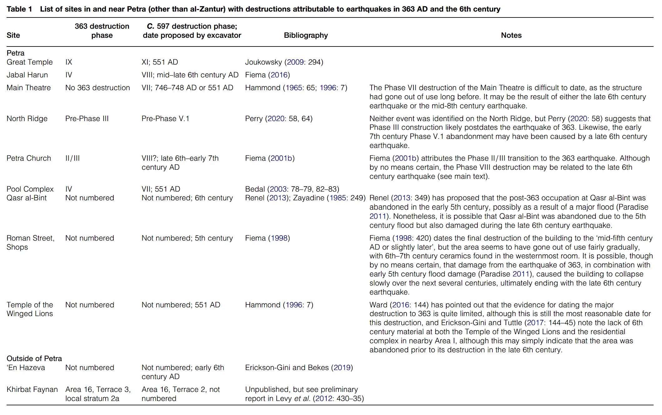 Table 1
List of sites in and near Petra (other than al-Zantur) with destructions attributable to earthquakes in 363 AD and the 6th century
Jones (2021)
- from Jones (2021)
Figure 2Map of Petra with the locations of major excavations marked
Jones (2021)
Basemap: Esri, Maxar, Earthstar Geographics, USDA FSA, USGS, Aerogrid, IGN, IGP, and the GIS User Community
| Effect | Location | Image | Description |
|---|---|---|---|
| Open crack in pavement |
 Figure 6
Location unspecified An open crack (covered with construction debris) in the loose soil, apparently formed during the earthquake of 363 Korzhenkov et al (2016) |
Open crack thought to have formed in the 363 CE earthquake - later filled with construction debris- paraphrased from a translation of Korzhenkov et al (2016) |
- download these files into Google Earth on your phone, tablet, or computer
- Google Earth download page
| kmz | Description | Reference |
|---|---|---|
| Right Click to download | Master kmz file | various |