...
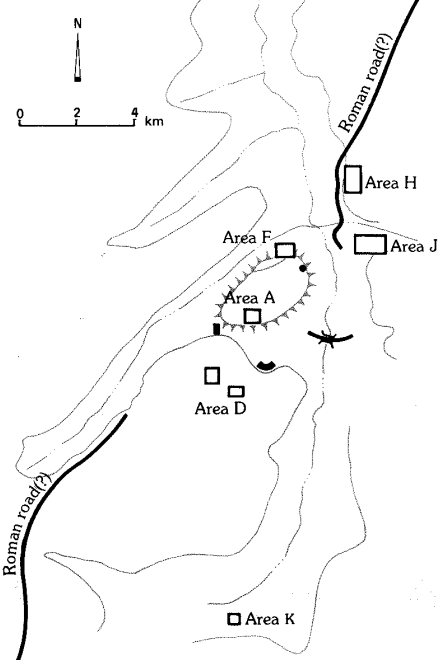
The present essay will survey three of the monumental
structures at Abila that show clear evidence of being
impacted by the earthquake of 749, the church on the
summit of the north tall labelled area A, the church on
the summit of the south tall labelled area D, and the
church located near the eastern base of the north tall,
along the western edge of the Wadi Qweilbah and the
Roman Bridge that joins the two sides of the wadi. Then,
I will survey some of the indicators that give evidence of
continued occupation after the collapse of these structures
in 749.
Excavation on the summit of the north tall began in 1982
under the direction of Duane Roller of Wilfrid Laurier
University, and quickly uncovered what was believed to
be part of an apse of a Byzantine basilica
5. In 1994 a
life-sized statue of Diana/Artemis was found in the area,
and so excavators have assumed that in a previous life the
area was home to a Roman temple. In addition, coins
minted at Abila, all of which date between the middle of
the second and the first quarter of the third centuries AD,
commonly depict a large temple at the site
6. Most of the
excavation of the structure in area A was done during the
1990s, but one final season was needed in 2006 to answer
a few lingering questions — namely, our quest for some
clear indication of Roman occupation. That season we
excavated a few sealed loci beneath a limestone paved
plaza just south of the basilica and encountered clean late
Roman pottery calls dating that plaza, at least, to the
period in which we hypothesized there was a Roman
temple, which was confirmed through the statue of
Diana/Artemis that was uncovered in the area and the
coins depicting such
7.
Although several of the early seasons were directed by
various archaeologists, most of the area was excavated by
John Wineland up through a final season in the field
during the summer of 2006.
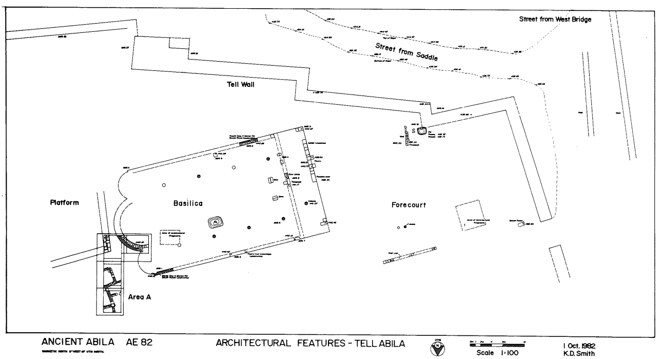
The structure is a tri-apsidal
basilica, with all three apses facing east, and measures
35 m from the outer edge of the central threshold to the
outside edge of the central, salient apse and 20 m from
the outside edges of the north–south walls. Excavation in
1992 focused on the western edge of the basilica and an
atrium measuring 16 m by 20 m was uncovered, paved
with the larger 3 cm square tesserae commonly found in
the atriums of the churches at Abila.
Wineland proposes
that the church continued in use until the massive
earthquake that struck the region in the middle of the
eighth century, after which it was used for domestic and
light industrial occupation into the Early Abbasid period.
The discussion of this material in the early excavation
reports unfortunately seems somewhat confused. Horace
Hummel of Concordia Seminary in St. Louis who
excavated the area in 1984 notes that the area had four
distinct periods of occupation — modern, Umayyad,
Byzantine, and pre-Byzantine
8. Hummel suggests that a
stash of sixteen Corinthian-style capitals and six column
drums that were hoarded in squares 8 and 10 were used
to divide the 'former church' into smaller domestic or
industrial units in the Umayyad period. The destruction
of the church structure, according to Wineland (following,
it appears, Horace Hummel) came about during the attack
of the Sassanid invasion after which the church was reused
in a rather haphazard and informal way into the Umayyad
period
9. The excavators are not to be faulted for this sort
of assumption, I don't think. Knowledge of early Islamic
archaeology — both the typology of the pottery and
sequencing of strata — was still in its infancy in the 1980s.
Indeed,
David Chapman and Robert Smith, in their
re-evaluation of this material correctly conclude that the
destruction of this structure came about from the 749
earthquake10. What this means, of course, is that the
domestic and light industrial occupation found in the
aftermath of the destruction of 749 is not 'Umayyad' but
rather 'Abbasid', or more properly, late eighth-century
and beyond. One coin that was identifiably Islamic was
found in the excavation of these remains, but regrettably
was catalogued with the Department of Antiquities before
it was studied, and so no more precise identification is
possible at this time
11.
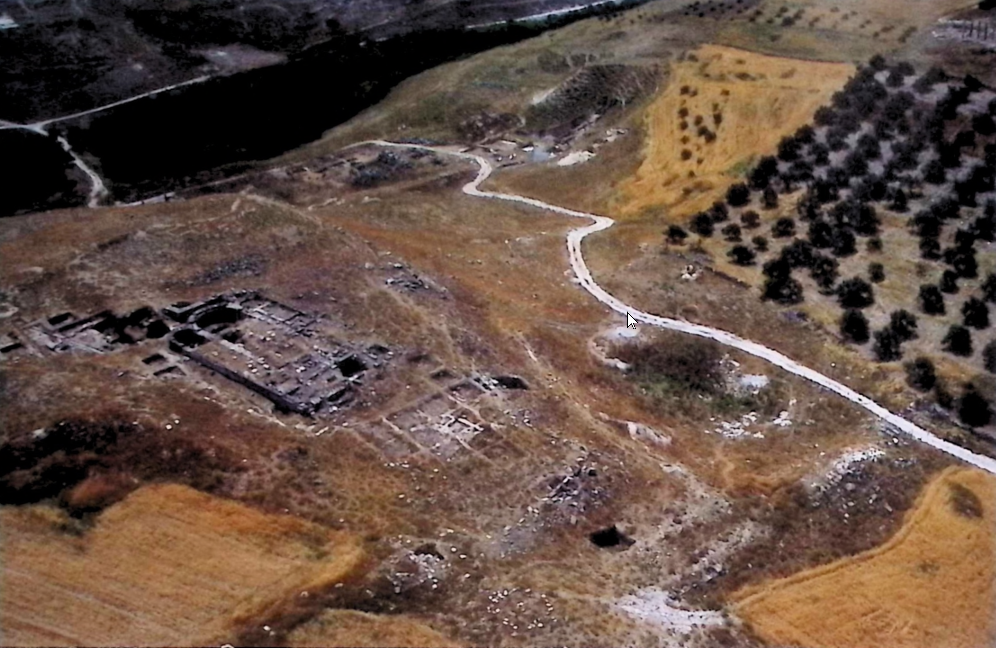
What is more important for my present purposes, though,
is that during the 1984 season of excavation, Duane
Roller opened a square on the north-eastern edge of the
basilical structure in area A. In that square the very finely
constructed corner of a large edifice was uncovered (Fig. 6.2).
From the excavation of that square, it was determined that the
building was constructed using basalt ashlars from the
destroyed basilica in area A. The dating sequence according
to Roller, and followed by Wineland as outlined above, was
that the basilica was destroyed during the Sassanid invasion,
and that the structure of which the corner was located in
the new square was built thus during the Umayyad period.
The structure was assumed to be an Umayyad public
building since it is a very large, rectangular structure
12. As I
have discussed elsewhere, though, the structure is likely a
large, late eighth-century mosque
13. The structure is situated
1.5 m due east of the main Byzantine basilica on the north
tall and measures 34.5 m in width east–west by 19 m in
length north–south enclosing a total area of approximately
650 m². The orientation of the building is 164 degrees
south-east, where the qibla at Abila is at roughly 160
degrees, and the one entrance that was located in this
initial probe enters from the north
14. The location of this
entrance along the western edge of this north wall would
seem to indicate that there should be at least one, or
possibly two more entrances along this northern wall. In
addition, Mattia Guidetti, in his discussion of "The
Contiguity of Churches and Mosques" argues: "When it
came time to build a congregational mosque, the site
selected was often an urban area adjoining an extant main
church."
15 And with numbers of the examples that Guidetti
mentions, it is common for the mosque structures to be
built on the east side of the churches when the limitations
of space and geography permit. The summation of this
material is that, though the earthquake of 749 devastated
the church structure built in area A, it also provided the
means for continuing domestic and light industrial
occupation in that same structure to continue, and more
significantly, for the construction of a large mosque to
accommodate the growing Muslim population of Abila in
the post-earthquake life of the city
16. While the precise
identification of the large Abbasid structure on the north
tall cannot at this time be identified as a mosque — which
would indicate a large and somewhat vigorous Muslim
population at Abila in the aftermath of the 749 earthquake
— at the very least, the continued occupation of Abila is
demonstrated by the presence of this large structure.
The excavated remains on the top of the south tall also
give strong evidence of both significant damage from a
catastrophic event, but also of the continued use of the area
after said event. Work in this area, labelled area D, began
in 1984 with the excavation of two 15 x 1 m trenches, one
on the summit of the tall and the other in what appeared
to be an open field just to the south where it was
hypothesized that a Roman forum might be found
17. The
latter probe uncovered what appeared to the excavators to
be Byzantine domestic occupation. The former trench was
placed in an area that Gottlieb Schumacher referred to as a
Roman temple, on account of the various column drums
visible from the surface
18.
In the trench opened by the Abila
excavators, they soon discovered a Corinthian capital with
a cross inscribed on it, and a black and red checkerboard
limestone floor surface. In addition, as more of this area
was excavated, the lay of the columns indicated to the
excavators that it had fallen in a seismic event, likely our
earthquake in 749. Wineland notes from a personal
conversation with Reuben Bullard, the Staff Geologist with
the Abila Excavation that the evidence seemed to him to
point to a catastrophic seismic event19. There was also
evidence in the nave of the church of depressions from
ashlars that had fallen, breaking through the floor surface.
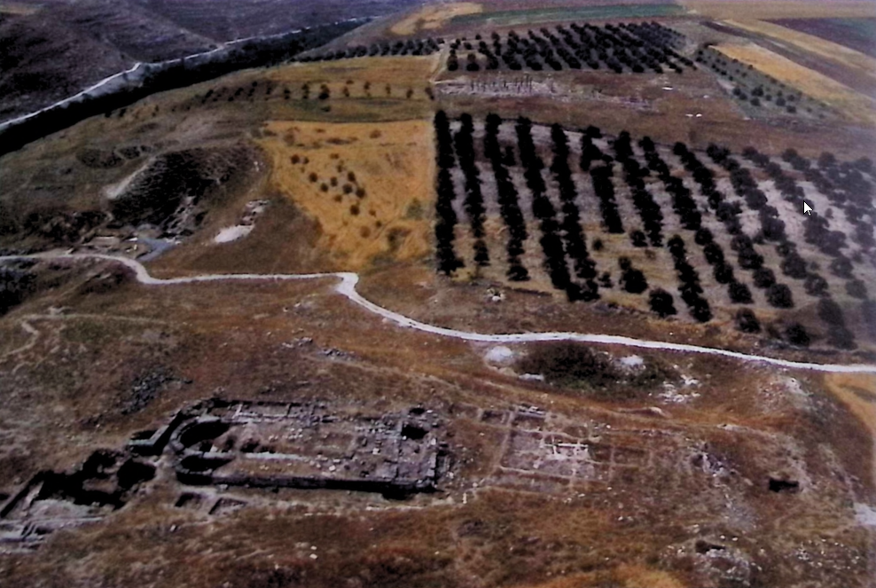
Excavation in area D continued through the summer of
2006 and revealed a tri-apsidal basilica with a baptistry
along the outer north-west wall (Fig. 6.3).
On the south of the structure numbers of rooms were
uncovered that were likely pastophoria, but showed
continued domestic occupation into the late eighth and
probably into the tenth century. Thus, due to the
significant damage done to the church structure it
almost certainly ceased being used as a church, but
domestic occupation continued for at least two more
centuries, primarily in the rooms adjacent to the church
on the south side.
21
During the 1992 season, while excavating along the
western edge of the atrium of the area D church, what
appeared to be the top of a monumental staircase was
visible from the surface. Upon further exploration
excavators landed upon what appeared to be part of an
apse, and no evidence of a staircase was found. So, work
there was halted until the 1994 season when excavation
resumed under the label of area DD.
Work in DD uncovered a basilical structure measuring
19.5 m from the threshold to the edge of the central apse
and 15 m from the edges of the north and south aisles.
This is the smallest of the churches at Abila. The north
and south aisles were covered in mosaic flooring, while
the nave was paved with sheets of marble 1 m by 60 cm
and 1 cm thick, large portions of which remained in situ.
The structure is tri-apsidal but curiously, unlike all the
other tri-apsidal churches at Abila where the nave apse
is somewhat larger than the other two, in this church all
three apses are of identical size. Several stylobates were
uncovered in situ, but there were no capitals, columns,
or bases. Excavators have assumed that this church
likely fell into disuse and was robbed out to build the
church in area D, described previously. Excavators also
found an empty sarcophagus that was placed across the
eastern end of the north aisle that had been used for
mixing plaster, again, probably for use in the construction
of the area D church. As with the two previously
described churches, this structure also had significant
domestic occupation during the Umayyad and Abbasid
periods. Excavators located both an upper and nether grindstone,
numbers of ash pits, several storage containers, as well as
significant pottery dating to the Umayyad period, and
even more dating to the Abbasid period, including some
whole objects. Structural modifications to the north aisle
and nave, especially, with walls bisecting both gave
evidence of the domestic use of the structure after it had
ceased being used as a church.
22 Significant also was
the finding of numbers of whole glass lamps and a bronze
ewer with a handle in the shape of a panther/leopard.
23
These were sitting on 15 cm of soil, above the church
floor, and so the excavator’s assumption is that they were
from the area D Church where, after falling in the
earthquake of 749, significant artefacts were stashed in
the area called area DD for safekeeping. Work in the area
DD church was completed in 2006, and along with the
occupation area D on the summit of the south tall and
that of area A on the north tall, provides evidence of
continued occupation at Abila, into the early medieval
period.
24
Excavation in area B began in 1986, under the direction
of Bastiaan Van Elderen and continued until shortly
before his passing in 2004. In his survey of Abila in the
late nineteenth century, Gottlieb Schumacher described
the remains of a Roman theatre, complete with seats
visible from the surface in the area currently designated
area B.
25 Nelson Glueck, in his visit to Abila in 1942
likewise saw what he believed to be a Roman theatre, but
noted that there were no seats visible, and described the
remains in much less detail than Schumacher (Fig. 6.4).
26
In time, excavation uncovered little evidence of a
theatre, despite the unnatural curvature of the hillside,
but did uncover what appears to be a monastic complex
that functioned into the early medieval period. Although
the structure has only been partially excavated, due to
fear of collapse from material high on the hillside,
excavations did uncover a single apse facing east, in what
is believed to be a chapel. A layer of ash and pottery dated
to the ‘Ayyubid/Mamluk’ periods led the excavators to
conclude that this structure was used for domestic
occupation into the twelfth century and beyond.
27 Just
north-west of the ‘monastic complex’ in area B, and
along the edge of a basalt road that runs north–south
curving in front of area B, recent excavations have
uncovered what is believed to be an early medieval
marketplace. The ‘stalls’ in this marketplace lie on the
western edge of the basalt road, and were laid in what
was an open-air plaza — evidence of the encroachment
of these structures into public space in the early medieval
period. Finds in this area have uncovered several of the
shops, with structures for grain storage, as well as several
associated whole objects, including an eighth-century
juglet and a glass stamp, similar to ones discovered at Beit
Shean (Fig. 6.5).
28
Excavation in area B is still in its early stages, and so not
much more can be said at present beyond that there was
at least some continued occupation after the 749
earthquake. The extent of that occupation will only be
known as more of this area is excavated.
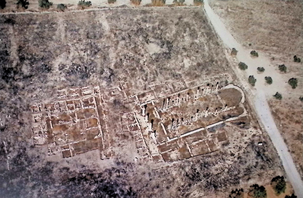
A final area of the site that will be discussed is the
basilica found in area E. Excavation in area E began in
1990, and has continued down to the present.29 The
church in area E is tri-apsidal, though unlike the other
churches at Abila, this one has the north and south apses
facing north and south respectively — in a clover-leaf, or
cruciform shape (Fig. 6.6).
The structure measures 25.4 m from the threshold to the
outer edge of the central apse and 26.6 m from the edges
of the north and south walls of the sanctuary, being wider
than it is long with four aisles and then the nave. To the
west, a narthex measuring 5.5 m extends to the back
retaining wall that runs up against the side of the
northern tall. Two cisterns were located in the narthex,
one on the north and the other on the south sides. And on
the west wall excavators uncovered what appears to be a
bench and a seat built right into the retaining wall. Along
the south of the structure pastophoria were excavated.
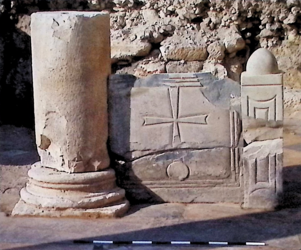
Numbers of crosses were carved into walls and columns.
And interestingly, along the south wall three niches were
located. Two of them had been filled with plaster in
Antiquity leaving only one open, thus looking suspiciously
like a mihrab (Fig. 6.7).
In 1991, the late Suliman Basheer published a study of
the literary references to the early use of church
structures for Muslim prayer.
30 And more recently, in
an essay on the relationships between church and mosque
structures in the Levant, Mattia Guidetti discusses a few
examples where it seems that similar things are happening,
though he tends to downplay the existence of churches
functioning with the faithful of both traditions. I’m fairly
convinced that we do have here pastophoria that were
converted into a musalla at some point during the
Umayyad period, the remaining niche functioning as a
mihrab.
31 What complicates matters somewhat is that
carbon dating of an olive pit extracted from the central
niche dates it between the second to third quarters of the
seventh century, which may be too early to have a mihrab,
much less one in a church. More work will need to be
done to confirm whether this is or is not a very primitive
musalla in the area E church.
In the south-west corner of this structure a chapel was
located. The floor was paved with black and white
checkerboard squares and there was an altar screen set up
in the middle of the room adjacent to a small column.
Across the lower part of both the column and the altar
screen there is a break, which seems to us to be consistent
with a catastrophic seismic event (Fig. 6.8).
As will be discussed below, pottery associated with what
appears to be earthquake damage in this area all date to
the middle of the eighth century. Throughout the church,
most of the floor surfaces were paved in sheets of marble,
and on many of the standing walls there were hooks for
hanging marble facing also. A few, but not many ashlars
were uncovered with the remains of painted plaster on
them. During the 2010 season of excavation, irregularities
observed on the outside of the east wall of the structure
on the south side of the apse led excavators to hypothesize
about the phasing of the structure, and so a probe was
taken 3 m on the opposite side of that wall, in the interior
of the church. That probe landed on a paved mosaic
surface and so squares were opened in the north and
south aisles that
revealed what we are fairly certain is an
earlier church located 1 m below the one being excavated.
Crosses in the middle of the aisles as well as an altar
screen with a cross in front of it in the north aisle seem
to confirm such a view.
No more work was done on this
lower church because of a desire not to disturb the upper
church. Various things have led us to conclude that the
upper church was destroyed in the mid-eighth-century
earthquake. The lay of columns as they were being
excavated, indentations in the floor surfaces from ashlars
that fell from a significant height, as well as numbers of
whole objects, such as a green glazed pot and other
pottery and metal objects which clearly belong to the
eighth century which were crushed under falling debris,
seem to confirm that the church was destroyed in the
mid-eighth century (Fig. 6.9).
32
In probes under the floor surface of the upper church,
four burials were located. All of the burial pits were
oriented east/west, with the deceased facing south, that
is, toward the qibla. Recent radiocarbon of a tooth from
one of these burials dated it with 82 per cent certainty to
a range of AD 870–992, consistent with other evidence
about the continued occupation of the area into the tenth
century and beyond.
33
Another element related to the use of the structure in
area E in a post-earthquake environment is the presence
of numbers of Arabic inscriptions throughout the area —
on columns, around the opening of a cistern, as well as
on a plaster wall in what appears to be a baptistry on the
north side of the structure. The inscriptions were being
deciphered by Andrea Zerbini and Firas Biqain, until the
untimely and tragic passing of the former. We hope that
within a short time we will be able to publish the findings
of this important evidence of the continued use of the
structure in a post-ecclesial setting.
In light of the evidence presented above, it is clear that,
although the mid-eighth-century earthquake had a significant
impact on the monumental architecture at Abila of the Decapolis,
there was continued occupation at the site, at least into the
tenth or eleventh century. Regrettably, over the past forty
years of excavation most of the excavation work has been
focused on the monumental structures at the site, and so
we arc less able to tell what the occupation and continuity
of the city was in a broader sense. Abila is a large site,
and future excavation work moving into the areas of domestic
occupation will be able to provide more precise data for the
lingering occupation at the site, which I am confident will
show that although the earthquake had a devastating impact on
the city, occupation continued for several centuries and possibly beyond.
Footnotes
5 Roller 1983, especially 16-22.
6 Wineland 2001, see chapter 6 for a discussion of this. See also de Saulcy 1874, pl. 16.
7 Mare 1999a.
8 Hummel 1985. 16-33.
9 Wincland 2001. 112.
10 Chapman and Smith 2009.
11 Wineland 2001, 27.
12 Roller 1984. In later excavations, Horace Hummel suggests that the structure
might be either an administrative building or a mosque, but still dates it to
the 'Umayyad' period. Sec Mare and others 1984; 1985; 1986.
13 Vila 2016; 2018.
14 Thlough, of course, orientation of the earliest mosques was less
a matter of precise scientific orientation than of general direction.
See King 1982; and King and Hawkins 1982, 102-09.
15 Guidetti 2017, 52 as well as Guidetti 2015, especially 11-27.
16 Vila (forthcoming).
17 Grothe 1985, 35-63; and Wincland 2001, 30-32.
18 Schumacher 1889, 25-27.
19 Wineland 2001, 31 n. 75.
20 Wineland 2001, 33.
21 The post-ecclesial use of the structure and adjacent rooms is discussed in Chapman and Smith 2009, 525-33.
22 Vila 2016, 162-63 and references there.
23 Mare and others 1994; 1995; 1996.
24 Vila 2016, 157-66 and Avni 2014, 221-22.
25 Schumacher 1889, 30 -32.
26 Glueck 1951. 125.
27 Van Elderen 1989, 10-20.
28 Hadad 2002. 35-48. The inscription on the stamp from area B at Abila is awaiting further study.
29 Although excavations are ongoing. this is the most published structure at Abila. See discussions in Vineland 2001, 38-03 as
well as Mare 1994; 1995; 1996. 2-5, 12-13; 1997, 25-44: 1999b. 11-12; 2000; Menninga 2004, 40-49; and Smith 2018,649-61.
30 Bashcar 1991, 267-82.
31 I've discussed this in several places, including Vila 2018 and Vila (forthcoming).
32 Vila 2016, 157-66.
33 Radiocarbon dating was performed by Beta Analytic Testing Laboratory on 13 April 2022.
For parallel studies of other early Islamic period burials in the region see Srigyan 2020.
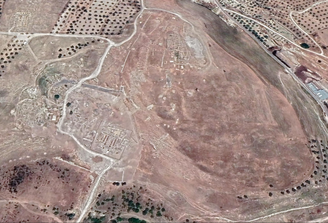
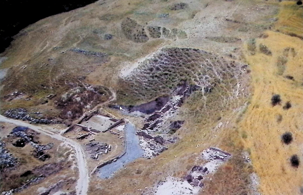
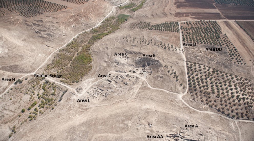 Aerial View of Abila
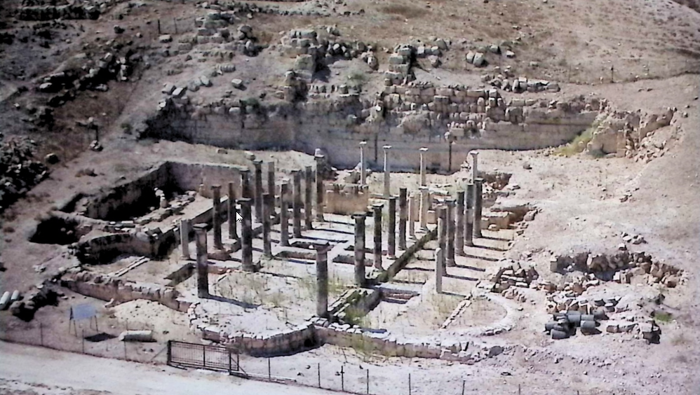