Dir Hagla Trenches
 Figure 9
Generalized sections of the main fault zone in Trench 3, with the structures that formed during past earthquakes. Two major events can be distinguished. For more details compare with Figs. 7 and 8
Reches and Hoexter (1981)
Maps, Aerial Views, Trench Log, and Photos
Maps
Normal Size
- Fig. 1c Location Map
from Reches and Hoexter (1981)
 Fig. 1c
Site location of present study. Grid numbers refer to Israel Grid (in km.)
JW: Reches and Hoexter (1981:238) note that trench locations are marked by 1, 2, and 4
Reches and Hoexter (1981)
Magnified
- Fig. 1c Location Map
from Reches and Hoexter (1981)
Fig. 1c
Site location of present study. Grid numbers refer to Israel Grid (in km.)
JW: Reches and Hoexter (1981:238) note that trench locations are marked by 1, 2, and 4
Reches and Hoexter (1981)
Aerial Views
Normal Size
- Dir Hagla Trenches area in Google Earth
 Dir Hagla Trenches area
Trench Location(s) is approximate
click on image to explore this site on a new tab in Google Earth - Dir Hagla Trenches area
on govmap.gov.il
 Dir Hagla Trenches area
Trenches are described as being east of the Dir Hagla monastery
click on image to explore this site on a new tab in govmap.gov.il
Magnified
- Dir Hagla Trenches area in Google Earth
Dir Hagla Trenches area
Trench Location(s) is approximate
click on image to explore this site on a new tab in Google Earth - Dir Hagla Trenches area
on govmap.gov.il
Dir Hagla Trenches area
Trenches are described as being east of the Dir Hagla monastery
click on image to explore this site on a new tab in govmap.gov.il
Trench Logs
Location Maps
Google Earth
Dir Hagla Trenches areaTrench Location(s) is approximate
click on image to explore this site on a new tab in Google Earth
Reches and Hoexter (1981)
Fig. 1c Site location of present study. Grid numbers refer to Israel Grid (in km.)
JW: Reches and Hoexter (1981:238) note that trench locations are marked by 1, 2, and 4
Reches and Hoexter (1981)
Trench 3 (simplified)
Figure 9Generalized sections of the main fault zone in Trench 3, with the structures that formed during past earthquakes. Two major events can be distinguished. For more details compare with Figs. 7 and 8
Reches and Hoexter (1981)
Individual Trench Logs and Illustrations
3D Illustration of Trenches
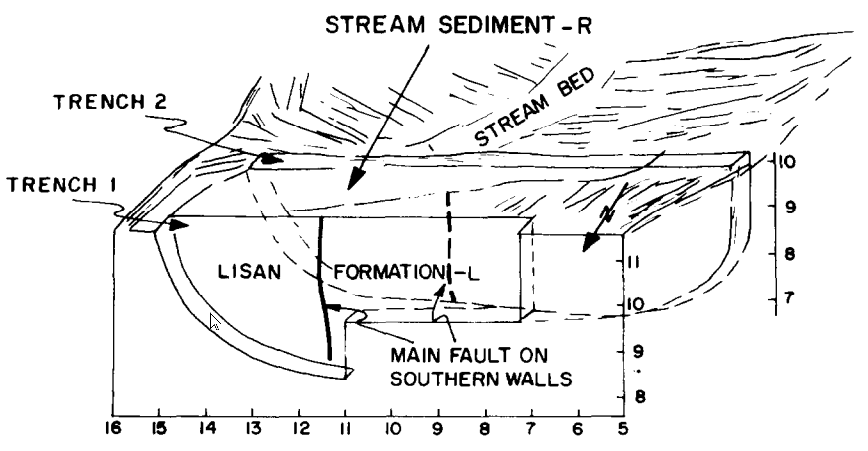 Figure 3
The southern trenches across the Jericho fault (location 1, Fig. 1c). Numbers on the frame indicate the local coordinate system, in meters, of these two trenches
click on image to open in a new tab
Reches and Hoexter (1981)
Stratigraphic sections
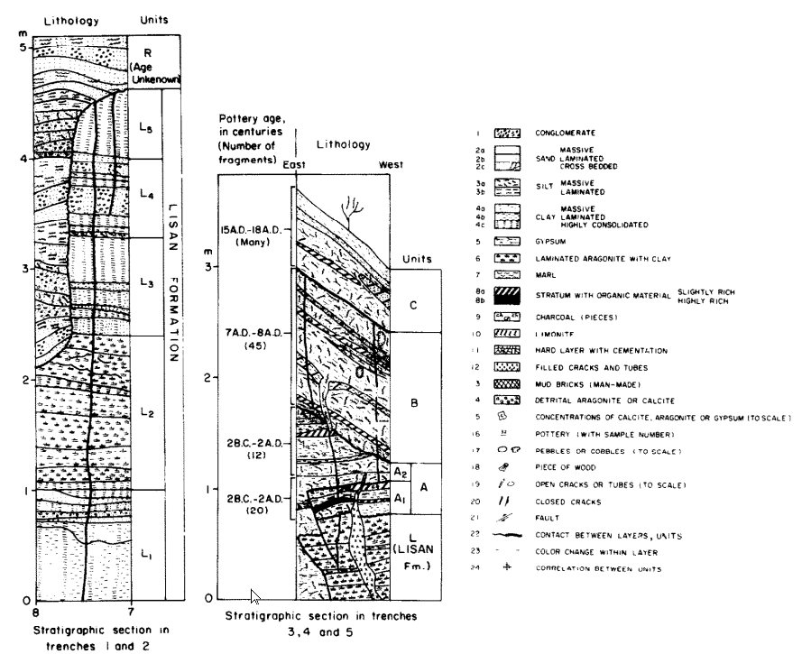 Figure 4
Stratigraphic sections of the southern trenches (1 and 2) and the central trenches (3, 4, 5 and 6).
click on image to open in a new tab
Reches and Hoexter (1981)
Trench 1 (Southern Wall)
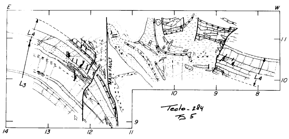 Figure 5
Section of the southern wall of trench 1 (location 1, Fig. 1). The trench trends to 115°. Field mapping at scale of 1 : 10. Legend in Fig. 4 and relationship to trench 2 in Fig. 3. All sediments are of the Lisan Formation (Fig. 4). The flexed layers dip to the northwest. Horizontal slickensides were found on the main fault. Note the layer with cross-bedding, unit L4 (Fig. 4) in both sides of the fault.
click on image to open in a new tab
Reches and Hoexter (1981)
Trench 2 (Southern Wall)
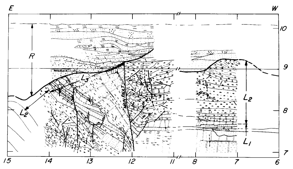 Figure 6
Section of the southern wall of trench 2, 9 m south of trench 1 (Fig. 3). The trench trends to 115°. Field mapping at scale of 1 : 10. Legend in Fig. 4 and relationship to trench 1 in Fig. 3. The section was shortened between coordinates 8.0 and 11.0 where bedding was continuous and horizontal. The lower part of the sequence is of Lisan Formation which is overlain unconformably by recent stream sediments (Fig. 4).
click on image to open in a new tab
Reches and Hoexter (1981)
Trench 3 (Southern Wall)
 Figure 7
Section of the western part of the southern wall of trench 3 (location 2, Fig. lc and Fig. 2). The eastern continuation of this section is shown in Fig. 8. The trench in E—W direction. Field mapping at scale of 1 : 10. Legend in Fig. 4.
click on image to open in a new tab
Reches and Hoexter (1981)
Trench 3 (Eastern Part of Southern Wall)
 Figure 8
Section of the eastern part of the southern wall of trench 3 (location 2, Fig. lc and Fig. 2). The western continuation of this section is shown in Fig. 7. The trench in E—W direction. Field mapping at scale of 1 : 20. Legend in Fig. 4.
click on image to open in a new tab
Reches and Hoexter (1981)
Fissure Fill in Trench 5
 Figure 10
A wide fissure, bounded by two small faults, in trench 5. A sequence of unit A1 (Fig. 4) is preserved within the fissures but is eroded from both sides of it (drawn after a photograph).
click on image to open in a new tab
Reches and Hoexter (1981)
Bowl Shaped depression on N Wall of Trench 3
 Figure 11
A bowl-shaped depression in layers of unit B (Fig. 4) on the northern wall of trench 3 (Fig. 2). Coordinate system as in Fig. 7. The layered depression is underlain by two small faults that penetrate into the Lisan layers.
click on image to open in a new tab
Reches and Hoexter (1981)
Photos
Normal Size
- Fig. 2 Site of Central
Trenches from Reches and Hoexter (1981)
 Fig. 2
The site of the central trenches, on the margins of the Dir Hagla depression (location 2, Fig. 1c). The numbers refer to three parallel trenches excavated across the trace of the main fault
enhanced with A.I.
click on image to open in a new tab
Reches and Hoexter (1981)
Magnified
- Fig. 2 Site of Central
Trenches from Reches and Hoexter (1981)
Fig. 2
The site of the central trenches, on the margins of the Dir Hagla depression (location 2, Fig. 1c). The numbers refer to three parallel trenches excavated across the trace of the main fault
enhanced with A.I.
click on image to open in a new tab
Reches and Hoexter (1981)
Event A - 200 BCE - 200 CE
Discussion
Reches and Hoexter (1981)
Abstract
The Dead Sea is a large, active graben within the Dead Sea rift, which is bounded by two major strike-slip faults, the Jericho and the Arava faults. We investigated the young tectonic activity along the Jericho fault by excavating trenches, up to 3.5 m deep, across its trace. The trenches penetrate through Late Pleistocene and Holocene sediments. We found that a zone, up to 15 m wide, of disturbed sediments exists along the fault. These disturbed sediments provide evidence for two periods of intensive activity or more likely, for two major earthquakes, that occurred during the last 2000 years. The earthquakes are evident in small faults, vertical throw of a few layers, cracks, unconformities and wide fissures. We further documented evidence for recent sinistral shear along the Jericho fault in deformed sediments and damage to an 8th Century palace on a subsidiary fault. We suggest that the two earthquakes may be correlated with the 31 B.C. earthquake and the 748 A.D. earthquake, reported by the ancients.
Introduction
The Jericho Fault
The Jericho fault is the main subject of the present investigation. It trends for about 30 km in a N10° C direction along the west coast of the Dead Sea and then for about 50 km or more on land, north of the sea (Fig. 1). The Jericho fault is predominantly a strike-slip fault; however, locally there are extensional to compressional components. The southern segment of the fault, beneath the Dead Sea water (Fig. lc), has a normal component (Neev and Hall, 1978). A few kilometers north of the Dead Sea (location 1, Fig. 1c), however, the Jericho fault is essentially a strike-slip fault (see below). At location 2, only 1.5 km north of location 1, the fault again has an extensional component and a small depression is developed along the fault. Further to the north, along the same fault, an anticline is developed in the Lisan Formation (Garfunkel, pers. commun., 1980). This alternation of the local displacement, typical of strike-slip faults, is discussed by Garfunkel (this volume).
Disturbed Sediments Along The Jericho Fault
Methods
We excavated nine trenches across the Jericho fault in the area east of the Dir Hagla Monastery (Fig. 1c). The three southern trenches, numbered 1, 2 and 7, exposed Lisan and recent stream sediments (location 1 in Fig. lc). The five central trenches, numbered 3, 4, 5, 6 and 8, are on the margins of the small depression, or graben, which is bounded on the west by the Jericho fault (location 2 in Fig. lc). There is no clear fault bounding the depression on the east. In all five central trenches, we found sediments younger than 2500 years unconformably overlying the Lisan Formation or faulted against the Lisan sediments. In a group of three trenches (numbers 3, 5, 6, Fig. 2) which are located close to a spring, we found the best evidence of seismic events. The northern trench (number 9, location 4 in Fig. 1) exposes sediments of a present day stream, Wadi el-Qilt, which overlies the Lisan Formation and are displaced by a 0.8 m normal fault. ...
Stratigraphy
The Jericho fault cuts across sediments of the Lisan Formation as well as younger deposits (Fig. 1c). The sediments which were found in the trenches are shown in the stratigraphic sections of Fig. 4. The Lisan sediments include layers of clay up to 0.5 m thick, aragonite finely laminated with clay, and a few layers of sand and conglomerate (Figs. 4-6). The younger sediments, formed during the last few thousands years, were deposited as a prism on a fault scarp surface, over the Lisan sediments (Figs. 4, 7, 8). They are primarily clastic, mostly clay, silt and fine sand, which are deposited as slightly irregular layers. Local unconformities, cut-and-fill structures and onlapping structures are common. Several dark layers in the sequence, contain organic material and the remains of past fires. Small fragments of charcoal, bones and pottery occur in many layers. Some layers are partly cemented by secondary gypsum or calcite. Cementation boundaries correlate with bedding contacts. Several thin layers are composed of finely laminated clay which was deposited in undisturbed water bodies. Some layers contain concentrations of the shells of a snail, Melanopsis (sp.), indicating a local fresh-water source. No residual soil horizons have been recognized in the sequence. Layers are continuous laterally for up to a few meters, and only a few thin layers can be correlated between adjacent trenches. We have correlated groups of layers, units L, A1, A2, B, C and R according to lithological similarity (Fig. 4). Several of these units are bounded by unconformities. For example, top of unit L, base of units A1, A2, B and R (Figs. 4—8). In trenches 5 and 6 we found man-made structures which were built on and into the young sediments.
In summary, the stratigraphic sequence found in trenches 3, 4, 5 and 6 (Figs. 4, 7, 8) indicates subaerial elastic sedimentation of clay to sand grain size with minor amounts of subaqueous deposits. The pebbles and boulders in the sequence, were probably brought by man. The source area for sediments is local and transport is by wind and local runoff.
Dating of the Recent Sediments
Dating of the recent sediments in the present study is based on preserved fragments of pottery. Attempts at carbon-14 dating have not been successful due to the small amounts of organic material available and possible contamination by modern organic material. The age of the pottery fragments was established on the basis of their ornamentation and production style by Mr. Y. Porat, Department of Antiquities, Israel. Some of the pottery fragments are marked on the profiles of the trenches (Figs. 4, 7, 8). We found, in situ, about 150 pottery fragments, ranging in age from modern to 3500 years. Many of them are not indicative of a specific period. Only the youngest fragments found in a layer can, of course, be used for age determination. We therefore could date only groups of layers, rather than individual ones (Fig. 4).
The earthquakes and the displacements along the Jericho fault generated a 10-15 m wide zone of intensive deformation. The deformation features may be related to seismic events, if they form during the event, or during a period of few years following the event. On the other hand, some features may be attributed to geotechnical, groundwater or human causes which are not directly related to seismic events. The distinction between the seismic and nonseismic features is sometimes difficult. Presented below are the features which, according to our interpretation, are most likely of seismic cause. This is based on sense of motion, location and the nature of development of these features, and their similarity to features observed across other active faults.
Results
Introduction
We identified two "events" which occurred along the Jericho fault during the last 2000 years. These events, referred to as event A and event B, can be recognized in trenches 3, 4 and 5. Each event represents intensive seismic activity; however, due to the coarse lamination, it is impossible to ascertain if each one represents a single large earthquake or multiple earthquakes during a short period. In this study, we suggest that these events represent individual earthquakes and correlated them with historic records.
We have also found evidence for considerable slip along the Jericho fault in trenches 1 and 2. We will first describe the evidence for the two earthquakes, and will then present the information relating to the slip along the fault.
Event A
The older event is evident in unit A1 and, in part, in unit A2 as seen in the central trenches 3, 4 and 5 (Figs. 4, 9). Several small faults, wide fissures, filled cracks, significant vertical throw and large unconformities are thought to have resulted from this earthquake. The following is a detailed description of these phenomena.
Small faults, with displacements of up to a few tens of cm, cut through unit A1 (Fig. 4) in both trench 3 (Figs. 7, 8), and trench 5. These are faults with either reverse- or normal-separation, with either the east or west side downthrown. The fault surfaces are usually irregular, with no slickensides. The faults are truncated by unit A2 in locations 3464/096 and 3-198/090 (Figs. 8, 10). Wide fissures, bounded by small faults and filled with either layered (Fig. 10) or mixed sediments (3-091/115 in Fig. 7 and 3-213/083 in Fig. 8) cut through unit A1. Stratified layers of unit A1 are preserved in the fissures of trench 5, whereas this unit was eroded from both sides of the fissure (Fig. 10, and compare with fig. 18, Sieh, 1978b). A few filled cracks and pockets of mixed sediments occur within unit A1. For example, a vertical one meter long crack at location 3-178/090, an irregular crack at 3-235/077 or a small pocket at 3-210/084 (Fig. 8). Unlike the fissures described above, there is no displacement across the cracks and pockets.
A vertical separation of about 3.5 m is evident between the subhorizontal layers of unit A1 at 3-090/115 (Figs. 7, 9), and the same layers at 3-220/085 (Figs. 8, 9). This vertical separation poses several questions. Does it represent the throw during event A or an accumulative subsidence during the last 2000 years, or does this separation reflect the initial deposition of unit A1 on an inclined surface? The horizontality of unit A1 layers on both sides of the disturbed zone (Fig. 9), the continuity of the layers and their lithological consistency in trenches 3 and 5 indicate that this unit was deposited on a relatively stable, horizontal surface. Units B and C (Fig. 4), on the other hand, have a distinctive eastward thickening and inclination (Figs. 7, 8). We thus conclude that the 3.5 m vertical separation is not depositional, but rather the local tectonic throw. This vertical separation occurred during event A or during a period of a few hundreds years, following event A and preceding event B. At present, we prefer the first possibility, but there are no evidence to reject the second. One should note, however, that the horizontal slip along the Jericho fault, associated with event A is not simply related to the local throw. The latter may be significantly increased due to variation of the fault attitude (e.g. Eyal, 1973), fault trend (e.g. Garfunkel, this volume) or the en-echelon pattern (e.g. Freund and Garfunkel, 1976).
Finally, the top of unit A is bounded by a clear unconformity (Figs. 4, 7, 8, 9). For example, the base of unit B is deposited on an inclined surface cutting through Lisan and unit A1 layers, whereas unit A2 has been completely eroded away (right upper side of Fig. 7; Fig. 9). This unconformity can also be traced in the eastern side of the main fault (note thinning of unit A2 in Fig. 9). The large vertical throw, discussed above, probably produced a fault scarp at the site of the trenches. Intensive erosion probably converted this scarp into a debris controlled slope in a relatively short period (e.g. Wallace, 1978). We think that this major unconformity at the base of unit B may represent the stage of fault scarp erosion at the time of deposition of unit B.
The age of unit A is determined by using an assemblage of 35 identifiable pottery fragments. The fragments range from the Iron Age to Early Roman, namely, from about the 12th century B.C. to the first century A.D. Because of reworking, the youngest fragments indicate the maximum age of this unit, which is about 1900-2000 years. The coarse stratigraphy and the relative scarcity of useful pottery fragments prevent a more specific age determination.
Conspicuous among the historic records of seismic events during this period is a vivid description by Josephus of an earthquake in the year 31 B.C. (Josephus, "Antiquities of the Jews", Book XV, Ch. 5). He wrote: "At this time it was that the fight happened at Actium, between Octavius Caesar and Anthony in the seventh year of the reign of Herod and it was also that here was an earthquake in Judea, such a one as had not happened at any other time and this earthquake brought a great destruction upon the cattle in that country. About 10,000 men also perished by the fall of houses, but the army, which lodged in the field, received no damage by this sad accident." It is feasible that this earthquake may be the same as "event A".
Event B
Evidence for a second earthquake in the central trenches can be seen in unit B (Figs. 4, 9). This event is recognized by bowl-shaped depressions, open and closed cracks, vents, filled fissures and small faults. Some of these features are described in detail. Bowl-shaped depressions are characterized by oppositely facing layers or a bowl filled with disturbed sediments (Fig. 11). The bowl structures vary in width from about 20 cm (2-157/111 in Fig. 8) to almost 2.0 m (3-11/11 in Fig. 7). Most of the cracks in unit B are sub-vertical, with rough and irregular surfaces. A few cracks are open and their surfaces are coated with fine brown clay with flow striations. Several cracks are filled with an unsorted, non-laminated mixture of clastic material, with a few fragments of pottery (3-142/100 in Fig. 7). This mixture is loosely cemented by gypsum needles in a few places. Most of the cracks in trench 3 terminate close to the top of unit B (Fig. 9), suggesting that they developed at the end of the deposition of this unit. The filled fissures, 5-10 cm wide, which are common at the base of unit B (Figs. 7, 9), are somewhat similar to the filled cracks, described above. These wide fissures have irregular faces, without slickensides or apparent displacement. The occurrence of mixed sediments of unit B in the fissures (e.g. 3-11/10 in Fig. 7) indicates that they formed after the deposition of unit B. A few small faults with displacement of up to 10 cm also occur in unit B (e.g. Fig. 11).
The character of event B differs significantly from that of event A. The latter has clear faults and measurable throws, whereas the former has many extensional features with no apparent throw. The 9° eastward inclination of the top of unit B (Fig. 9) may suggest some continuous subsidence (aseismic?). On the other hand, this inclination may also be due to the degraded fault scarp of event A, which could have existed for thousands of years (e.g. Wallace, 1978). Due to the coarse layering, it is impossible to distinguish between two possible mechanisms.
The age of unit B is determined by the presence of a distinctive group of pottery fragments, dating from the Late Byzantine to Early Arabic times, namely 7–8 centuries A.D. This is the youngest assemblage in unit B, and thus, event B has probably occurred between the 7th Century and the 8th Century.
What is the slip associated with B? Could we correlate it with a known historic record? A hint of an answer is found in the nearby Hisham Palace, a luxurious complex built during the first half of the 8th Century just north of Jericho (location 3, Fig. 1). The ruins of the palace were studied in detail by Hamilton (1959), who proposed that the palace was destroyed by an earthquake, before the completion of its construction.
We found that the walls of the Hisham Palace have been subjected to severe fracturing, tilting, warping and distortion, which are consistent with sinistral horizontal shear. Figure 12 is the damage that we documented on Hamilton's map. Many rooms, particularly in the southeastern part, are rhomb-shaped (Figs. 12, 13a). The deviation of the rooms of the palace from rectangular form was attributed by Hamilton (1958, p. 63) to errors in measuring angles during construction. However, such errors could not explain the coherent continuous warping of many walls (Fig. 12) and the horizontal slip on several fractures (Figs. 12, 13b). As the wall warping, the slip along fractures and shape of rooms are all consistent with sinistral horizontal shear of the southeastern part of the palace (Fig. 12), tectonic deformation appears to be the reasonable explanation for most, if not all, damage phenomena. Begin (1975) traced an inferred fault trending N35°E, about 100 m west of the palace. We suggest that another fault, the Hisham fault, runs with similar trend through the palace (Fig. 1c).
Ben-Menahem (1981) suggests, on the basis of historical records, that the palace was destroyed by an earthquake in 748. He further suggests that this earthquake caused severe damage to hundreds of villages and death of tens of thousands of people. Ben-Menahem claims it was the strongest event in the region of Israel during the last 2500 years and attributes to it a magnitude of M > 7.
The observations of the structures in unit B, the deformation in the Hisham Palace, and the historic records are all consistent with a major earthquake in 748 along the Jericho fault. The predominant displacement during this event would have been horizontal shear, which caused no considerable throw at the central trenches. The sinistral slip along the Hisham fault is probably secondary to the main 748 slip. The deformation of the palace occurred during and after the 748 event.
Evidence of young events which post-date event B is rare. The upper 0.6-1.0 m sequence is primarily disturbed by man-made structures. A possible exception is the small bowl-structure with associated cracks in 3-157/111 (Fig. 8) which formed a few hundred years ago, during a small event (event C, Fig. 9).
Summary and Conclusions
Two large faults are active in the Dead Sea area, the Arava fault which bounds the sea on the east, and the Jericho fault on the west. We investigated in detail the land exposures of the latter in a 6 km segment. The Jericho fault is primarily a strike slip fault, with alternation of extensional and compressional components along its length. The seismic activity during the Holocene on the west side of the Dead Sea rift, in the Jericho region, has been concentrated along this fault.
We have found that the sediments which were deposited across the Jericho fault were disturbed by two large earthquakes or two periods of earthquakes during the last 2000 years. We found also evidence of a few intermediate seismic events. However, due to coarse sedimentation, and dating difficulties, it is impossible to determine the ages of the intermediate events. The first large event occurred between 200 B.C. and 200 A.D., and the second large one occurred between 700 A.D. and 900 A.D. The first event has a vertical throw of about 3.5 m at the trenches. The second event has a negligible vertical throw there, but it is probably associated with horizontal slip. The two seismic events have reasonable correlations with two historic events: the 31 B.C. and the 748 A.D. earthquakes. It is possible that only large earthquakes, during which the entire Jericho fault slipped, can be observed in the young sediments.
Event B - 600-900 CE
Discussion
Reches and Hoexter (1981)
Abstract
The Dead Sea is a large, active graben within the Dead Sea rift, which is bounded by two major strike-slip faults, the Jericho and the Arava faults. We investigated the young tectonic activity along the Jericho fault by excavating trenches, up to 3.5 m deep, across its trace. The trenches penetrate through Late Pleistocene and Holocene sediments. We found that a zone, up to 15 m wide, of disturbed sediments exists along the fault. These disturbed sediments provide evidence for two periods of intensive activity or more likely, for two major earthquakes, that occurred during the last 2000 years. The earthquakes are evident in small faults, vertical throw of a few layers, cracks, unconformities and wide fissures. We further documented evidence for recent sinistral shear along the Jericho fault in deformed sediments and damage to an 8th Century palace on a subsidiary fault. We suggest that the two earthquakes may be correlated with the 31 B.C. earthquake and the 748 A.D. earthquake, reported by the ancients.
Introduction
The Jericho Fault
The Jericho fault is the main subject of the present investigation. It trends for about 30 km in a N10° C direction along the west coast of the Dead Sea and then for about 50 km or more on land, north of the sea (Fig. 1). The Jericho fault is predominantly a strike-slip fault; however, locally there are extensional to compressional components. The southern segment of the fault, beneath the Dead Sea water (Fig. lc), has a normal component (Neev and Hall, 1978). A few kilometers north of the Dead Sea (location 1, Fig. 1c), however, the Jericho fault is essentially a strike-slip fault (see below). At location 2, only 1.5 km north of location 1, the fault again has an extensional component and a small depression is developed along the fault. Further to the north, along the same fault, an anticline is developed in the Lisan Formation (Garfunkel, pers. commun., 1980). This alternation of the local displacement, typical of strike-slip faults, is discussed by Garfunkel (this volume).
Disturbed Sediments Along The Jericho Fault
Methods
We excavated nine trenches across the Jericho fault in the area east of the Dir Hagla Monastery (Fig. 1c). The three southern trenches, numbered 1, 2 and 7, exposed Lisan and recent stream sediments (location 1 in Fig. lc). The five central trenches, numbered 3, 4, 5, 6 and 8, are on the margins of the small depression, or graben, which is bounded on the west by the Jericho fault (location 2 in Fig. lc). There is no clear fault bounding the depression on the east. In all five central trenches, we found sediments younger than 2500 years unconformably overlying the Lisan Formation or faulted against the Lisan sediments. In a group of three trenches (numbers 3, 5, 6, Fig. 2) which are located close to a spring, we found the best evidence of seismic events. The northern trench (number 9, location 4 in Fig. 1) exposes sediments of a present day stream, Wadi el-Qilt, which overlies the Lisan Formation and are displaced by a 0.8 m normal fault. ...
Stratigraphy
The Jericho fault cuts across sediments of the Lisan Formation as well as younger deposits (Fig. 1c). The sediments which were found in the trenches are shown in the stratigraphic sections of Fig. 4. The Lisan sediments include layers of clay up to 0.5 m thick, aragonite finely laminated with clay, and a few layers of sand and conglomerate (Figs. 4-6). The younger sediments, formed during the last few thousands years, were deposited as a prism on a fault scarp surface, over the Lisan sediments (Figs. 4, 7, 8). They are primarily clastic, mostly clay, silt and fine sand, which are deposited as slightly irregular layers. Local unconformities, cut-and-fill structures and onlapping structures are common. Several dark layers in the sequence, contain organic material and the remains of past fires. Small fragments of charcoal, bones and pottery occur in many layers. Some layers are partly cemented by secondary gypsum or calcite. Cementation boundaries correlate with bedding contacts. Several thin layers are composed of finely laminated clay which was deposited in undisturbed water bodies. Some layers contain concentrations of the shells of a snail, Melanopsis (sp.), indicating a local fresh-water source. No residual soil horizons have been recognized in the sequence. Layers are continuous laterally for up to a few meters, and only a few thin layers can be correlated between adjacent trenches. We have correlated groups of layers, units L, A1, A2, B, C and R according to lithological similarity (Fig. 4). Several of these units are bounded by unconformities. For example, top of unit L, base of units A1, A2, B and R (Figs. 4—8). In trenches 5 and 6 we found man-made structures which were built on and into the young sediments.
In summary, the stratigraphic sequence found in trenches 3, 4, 5 and 6 (Figs. 4, 7, 8) indicates subaerial elastic sedimentation of clay to sand grain size with minor amounts of subaqueous deposits. The pebbles and boulders in the sequence, were probably brought by man. The source area for sediments is local and transport is by wind and local runoff.
Dating of the Recent Sediments
Dating of the recent sediments in the present study is based on preserved fragments of pottery. Attempts at carbon-14 dating have not been successful due to the small amounts of organic material available and possible contamination by modern organic material. The age of the pottery fragments was established on the basis of their ornamentation and production style by Mr. Y. Porat, Department of Antiquities, Israel. Some of the pottery fragments are marked on the profiles of the trenches (Figs. 4, 7, 8). We found, in situ, about 150 pottery fragments, ranging in age from modern to 3500 years. Many of them are not indicative of a specific period. Only the youngest fragments found in a layer can, of course, be used for age determination. We therefore could date only groups of layers, rather than individual ones (Fig. 4).
The earthquakes and the displacements along the Jericho fault generated a 10-15 m wide zone of intensive deformation. The deformation features may be related to seismic events, if they form during the event, or during a period of few years following the event. On the other hand, some features may be attributed to geotechnical, groundwater or human causes which are not directly related to seismic events. The distinction between the seismic and nonseismic features is sometimes difficult. Presented below are the features which, according to our interpretation, are most likely of seismic cause. This is based on sense of motion, location and the nature of development of these features, and their similarity to features observed across other active faults.
Results
Introduction
We identified two "events" which occurred along the Jericho fault during the last 2000 years. These events, referred to as event A and event B, can be recognized in trenches 3, 4 and 5. Each event represents intensive seismic activity; however, due to the coarse lamination, it is impossible to ascertain if each one represents a single large earthquake or multiple earthquakes during a short period. In this study, we suggest that these events represent individual earthquakes and correlated them with historic records.
We have also found evidence for considerable slip along the Jericho fault in trenches 1 and 2. We will first describe the evidence for the two earthquakes, and will then present the information relating to the slip along the fault.
Event A
The older event is evident in unit A1 and, in part, in unit A2 as seen in the central trenches 3, 4 and 5 (Figs. 4, 9). Several small faults, wide fissures, filled cracks, significant vertical throw and large unconformities are thought to have resulted from this earthquake. The following is a detailed description of these phenomena.
Small faults, with displacements of up to a few tens of cm, cut through unit A1 (Fig. 4) in both trench 3 (Figs. 7, 8), and trench 5. These are faults with either reverse- or normal-separation, with either the east or west side downthrown. The fault surfaces are usually irregular, with no slickensides. The faults are truncated by unit A2 in locations 3464/096 and 3-198/090 (Figs. 8, 10). Wide fissures, bounded by small faults and filled with either layered (Fig. 10) or mixed sediments (3-091/115 in Fig. 7 and 3-213/083 in Fig. 8) cut through unit A1. Stratified layers of unit A1 are preserved in the fissures of trench 5, whereas this unit was eroded from both sides of the fissure (Fig. 10, and compare with fig. 18, Sieh, 1978b). A few filled cracks and pockets of mixed sediments occur within unit A1. For example, a vertical one meter long crack at location 3-178/090, an irregular crack at 3-235/077 or a small pocket at 3-210/084 (Fig. 8). Unlike the fissures described above, there is no displacement across the cracks and pockets.
A vertical separation of about 3.5 m is evident between the subhorizontal layers of unit A1 at 3-090/115 (Figs. 7, 9), and the same layers at 3-220/085 (Figs. 8, 9). This vertical separation poses several questions. Does it represent the throw during event A or an accumulative subsidence during the last 2000 years, or does this separation reflect the initial deposition of unit A1 on an inclined surface? The horizontality of unit A1 layers on both sides of the disturbed zone (Fig. 9), the continuity of the layers and their lithological consistency in trenches 3 and 5 indicate that this unit was deposited on a relatively stable, horizontal surface. Units B and C (Fig. 4), on the other hand, have a distinctive eastward thickening and inclination (Figs. 7, 8). We thus conclude that the 3.5 m vertical separation is not depositional, but rather the local tectonic throw. This vertical separation occurred during event A or during a period of a few hundreds years, following event A and preceding event B. At present, we prefer the first possibility, but there are no evidence to reject the second. One should note, however, that the horizontal slip along the Jericho fault, associated with event A is not simply related to the local throw. The latter may be significantly increased due to variation of the fault attitude (e.g. Eyal, 1973), fault trend (e.g. Garfunkel, this volume) or the en-echelon pattern (e.g. Freund and Garfunkel, 1976).
Finally, the top of unit A is bounded by a clear unconformity (Figs. 4, 7, 8, 9). For example, the base of unit B is deposited on an inclined surface cutting through Lisan and unit A1 layers, whereas unit A2 has been completely eroded away (right upper side of Fig. 7; Fig. 9). This unconformity can also be traced in the eastern side of the main fault (note thinning of unit A2 in Fig. 9). The large vertical throw, discussed above, probably produced a fault scarp at the site of the trenches. Intensive erosion probably converted this scarp into a debris controlled slope in a relatively short period (e.g. Wallace, 1978). We think that this major unconformity at the base of unit B may represent the stage of fault scarp erosion at the time of deposition of unit B.
The age of unit A is determined by using an assemblage of 35 identifiable pottery fragments. The fragments range from the Iron Age to Early Roman, namely, from about the 12th century B.C. to the first century A.D. Because of reworking, the youngest fragments indicate the maximum age of this unit, which is about 1900-2000 years. The coarse stratigraphy and the relative scarcity of useful pottery fragments prevent a more specific age determination.
Conspicuous among the historic records of seismic events during this period is a vivid description by Josephus of an earthquake in the year 31 B.C. (Josephus, "Antiquities of the Jews", Book XV, Ch. 5). He wrote: "At this time it was that the fight happened at Actium, between Octavius Caesar and Anthony in the seventh year of the reign of Herod and it was also that here was an earthquake in Judea, such a one as had not happened at any other time and this earthquake brought a great destruction upon the cattle in that country. About 10,000 men also perished by the fall of houses, but the army, which lodged in the field, received no damage by this sad accident." It is feasible that this earthquake may be the same as "event A".
Event B
Evidence for a second earthquake in the central trenches can be seen in unit B (Figs. 4, 9). This event is recognized by bowl-shaped depressions, open and closed cracks, vents, filled fissures and small faults. Some of these features are described in detail. Bowl-shaped depressions are characterized by oppositely facing layers or a bowl filled with disturbed sediments (Fig. 11). The bowl structures vary in width from about 20 cm (2-157/111 in Fig. 8) to almost 2.0 m (3-11/11 in Fig. 7). Most of the cracks in unit B are sub-vertical, with rough and irregular surfaces. A few cracks are open and their surfaces are coated with fine brown clay with flow striations. Several cracks are filled with an unsorted, non-laminated mixture of clastic material, with a few fragments of pottery (3-142/100 in Fig. 7). This mixture is loosely cemented by gypsum needles in a few places. Most of the cracks in trench 3 terminate close to the top of unit B (Fig. 9), suggesting that they developed at the end of the deposition of this unit. The filled fissures, 5-10 cm wide, which are common at the base of unit B (Figs. 7, 9), are somewhat similar to the filled cracks, described above. These wide fissures have irregular faces, without slickensides or apparent displacement. The occurrence of mixed sediments of unit B in the fissures (e.g. 3-11/10 in Fig. 7) indicates that they formed after the deposition of unit B. A few small faults with displacement of up to 10 cm also occur in unit B (e.g. Fig. 11).
The character of event B differs significantly from that of event A. The latter has clear faults and measurable throws, whereas the former has many extensional features with no apparent throw. The 9° eastward inclination of the top of unit B (Fig. 9) may suggest some continuous subsidence (aseismic?). On the other hand, this inclination may also be due to the degraded fault scarp of event A, which could have existed for thousands of years (e.g. Wallace, 1978). Due to the coarse layering, it is impossible to distinguish between two possible mechanisms.
The age of unit B is determined by the presence of a distinctive group of pottery fragments, dating from the Late Byzantine to Early Arabic times, namely 7–8 centuries A.D. This is the youngest assemblage in unit B, and thus, event B has probably occurred between the 7th Century and the 8th Century.
What is the slip associated with B? Could we correlate it with a known historic record? A hint of an answer is found in the nearby Hisham Palace, a luxurious complex built during the first half of the 8th Century just north of Jericho (location 3, Fig. 1). The ruins of the palace were studied in detail by Hamilton (1959), who proposed that the palace was destroyed by an earthquake, before the completion of its construction.
We found that the walls of the Hisham Palace have been subjected to severe fracturing, tilting, warping and distortion, which are consistent with sinistral horizontal shear. Figure 12 is the damage that we documented on Hamilton's map. Many rooms, particularly in the southeastern part, are rhomb-shaped (Figs. 12, 13a). The deviation of the rooms of the palace from rectangular form was attributed by Hamilton (1958, p. 63) to errors in measuring angles during construction. However, such errors could not explain the coherent continuous warping of many walls (Fig. 12) and the horizontal slip on several fractures (Figs. 12, 13b). As the wall warping, the slip along fractures and shape of rooms are all consistent with sinistral horizontal shear of the southeastern part of the palace (Fig. 12), tectonic deformation appears to be the reasonable explanation for most, if not all, damage phenomena. Begin (1975) traced an inferred fault trending N35°E, about 100 m west of the palace. We suggest that another fault, the Hisham fault, runs with similar trend through the palace (Fig. 1c).
Ben-Menahem (1981) suggests, on the basis of historical records, that the palace was destroyed by an earthquake in 748. He further suggests that this earthquake caused severe damage to hundreds of villages and death of tens of thousands of people. Ben-Menahem claims it was the strongest event in the region of Israel during the last 2500 years and attributes to it a magnitude of M > 7.
The observations of the structures in unit B, the deformation in the Hisham Palace, and the historic records are all consistent with a major earthquake in 748 along the Jericho fault. The predominant displacement during this event would have been horizontal shear, which caused no considerable throw at the central trenches. The sinistral slip along the Hisham fault is probably secondary to the main 748 slip. The deformation of the palace occurred during and after the 748 event.
Evidence of young events which post-date event B is rare. The upper 0.6-1.0 m sequence is primarily disturbed by man-made structures. A possible exception is the small bowl-structure with associated cracks in 3-157/111 (Fig. 8) which formed a few hundred years ago, during a small event (event C, Fig. 9).
Summary and Conclusions
Two large faults are active in the Dead Sea area, the Arava fault which bounds the sea on the east, and the Jericho fault on the west. We investigated in detail the land exposures of the latter in a 6 km segment. The Jericho fault is primarily a strike slip fault, with alternation of extensional and compressional components along its length. The seismic activity during the Holocene on the west side of the Dead Sea rift, in the Jericho region, has been concentrated along this fault.
We have found that the sediments which were deposited across the Jericho fault were disturbed by two large earthquakes or two periods of earthquakes during the last 2000 years. We found also evidence of a few intermediate seismic events. However, due to coarse sedimentation, and dating difficulties, it is impossible to determine the ages of the intermediate events. The first large event occurred between 200 B.C. and 200 A.D., and the second large one occurred between 700 A.D. and 900 A.D. The first event has a vertical throw of about 3.5 m at the trenches. The second event has a negligible vertical throw there, but it is probably associated with horizontal slip. The two seismic events have reasonable correlations with two historic events: the 31 B.C. and the 748 A.D. earthquakes. It is possible that only large earthquakes, during which the entire Jericho fault slipped, can be observed in the young sediments.
Event C - within the last few hundred years
Discussion
Reches and Hoexter (1981)
Abstract
The Dead Sea is a large, active graben within the Dead Sea rift, which is bounded by two major strike-slip faults, the Jericho and the Arava faults. We investigated the young tectonic activity along the Jericho fault by excavating trenches, up to 3.5 m deep, across its trace. The trenches penetrate through Late Pleistocene and Holocene sediments. We found that a zone, up to 15 m wide, of disturbed sediments exists along the fault. These disturbed sediments provide evidence for two periods of intensive activity or more likely, for two major earthquakes, that occurred during the last 2000 years. The earthquakes are evident in small faults, vertical throw of a few layers, cracks, unconformities and wide fissures. We further documented evidence for recent sinistral shear along the Jericho fault in deformed sediments and damage to an 8th Century palace on a subsidiary fault. We suggest that the two earthquakes may be correlated with the 31 B.C. earthquake and the 748 A.D. earthquake, reported by the ancients.
Introduction
The Jericho Fault
The Jericho fault is the main subject of the present investigation. It trends for about 30 km in a N10° C direction along the west coast of the Dead Sea and then for about 50 km or more on land, north of the sea (Fig. 1). The Jericho fault is predominantly a strike-slip fault; however, locally there are extensional to compressional components. The southern segment of the fault, beneath the Dead Sea water (Fig. lc), has a normal component (Neev and Hall, 1978). A few kilometers north of the Dead Sea (location 1, Fig. 1c), however, the Jericho fault is essentially a strike-slip fault (see below). At location 2, only 1.5 km north of location 1, the fault again has an extensional component and a small depression is developed along the fault. Further to the north, along the same fault, an anticline is developed in the Lisan Formation (Garfunkel, pers. commun., 1980). This alternation of the local displacement, typical of strike-slip faults, is discussed by Garfunkel (this volume).
Disturbed Sediments Along The Jericho Fault
Methods
We excavated nine trenches across the Jericho fault in the area east of the Dir Hagla Monastery (Fig. 1c). The three southern trenches, numbered 1, 2 and 7, exposed Lisan and recent stream sediments (location 1 in Fig. lc). The five central trenches, numbered 3, 4, 5, 6 and 8, are on the margins of the small depression, or graben, which is bounded on the west by the Jericho fault (location 2 in Fig. lc). There is no clear fault bounding the depression on the east. In all five central trenches, we found sediments younger than 2500 years unconformably overlying the Lisan Formation or faulted against the Lisan sediments. In a group of three trenches (numbers 3, 5, 6, Fig. 2) which are located close to a spring, we found the best evidence of seismic events. The northern trench (number 9, location 4 in Fig. 1) exposes sediments of a present day stream, Wadi el-Qilt, which overlies the Lisan Formation and are displaced by a 0.8 m normal fault. ...
Stratigraphy
The Jericho fault cuts across sediments of the Lisan Formation as well as younger deposits (Fig. 1c). The sediments which were found in the trenches are shown in the stratigraphic sections of Fig. 4. The Lisan sediments include layers of clay up to 0.5 m thick, aragonite finely laminated with clay, and a few layers of sand and conglomerate (Figs. 4-6). The younger sediments, formed during the last few thousands years, were deposited as a prism on a fault scarp surface, over the Lisan sediments (Figs. 4, 7, 8). They are primarily clastic, mostly clay, silt and fine sand, which are deposited as slightly irregular layers. Local unconformities, cut-and-fill structures and onlapping structures are common. Several dark layers in the sequence, contain organic material and the remains of past fires. Small fragments of charcoal, bones and pottery occur in many layers. Some layers are partly cemented by secondary gypsum or calcite. Cementation boundaries correlate with bedding contacts. Several thin layers are composed of finely laminated clay which was deposited in undisturbed water bodies. Some layers contain concentrations of the shells of a snail, Melanopsis (sp.), indicating a local fresh-water source. No residual soil horizons have been recognized in the sequence. Layers are continuous laterally for up to a few meters, and only a few thin layers can be correlated between adjacent trenches. We have correlated groups of layers, units L, A1, A2, B, C and R according to lithological similarity (Fig. 4). Several of these units are bounded by unconformities. For example, top of unit L, base of units A1, A2, B and R (Figs. 4—8). In trenches 5 and 6 we found man-made structures which were built on and into the young sediments.
In summary, the stratigraphic sequence found in trenches 3, 4, 5 and 6 (Figs. 4, 7, 8) indicates subaerial elastic sedimentation of clay to sand grain size with minor amounts of subaqueous deposits. The pebbles and boulders in the sequence, were probably brought by man. The source area for sediments is local and transport is by wind and local runoff.
Dating of the Recent Sediments
Dating of the recent sediments in the present study is based on preserved fragments of pottery. Attempts at carbon-14 dating have not been successful due to the small amounts of organic material available and possible contamination by modern organic material. The age of the pottery fragments was established on the basis of their ornamentation and production style by Mr. Y. Porat, Department of Antiquities, Israel. Some of the pottery fragments are marked on the profiles of the trenches (Figs. 4, 7, 8). We found, in situ, about 150 pottery fragments, ranging in age from modern to 3500 years. Many of them are not indicative of a specific period. Only the youngest fragments found in a layer can, of course, be used for age determination. We therefore could date only groups of layers, rather than individual ones (Fig. 4).
The earthquakes and the displacements along the Jericho fault generated a 10-15 m wide zone of intensive deformation. The deformation features may be related to seismic events, if they form during the event, or during a period of few years following the event. On the other hand, some features may be attributed to geotechnical, groundwater or human causes which are not directly related to seismic events. The distinction between the seismic and nonseismic features is sometimes difficult. Presented below are the features which, according to our interpretation, are most likely of seismic cause. This is based on sense of motion, location and the nature of development of these features, and their similarity to features observed across other active faults.
Results
Introduction
We identified two "events" which occurred along the Jericho fault during the last 2000 years. These events, referred to as event A and event B, can be recognized in trenches 3, 4 and 5. Each event represents intensive seismic activity; however, due to the coarse lamination, it is impossible to ascertain if each one represents a single large earthquake or multiple earthquakes during a short period. In this study, we suggest that these events represent individual earthquakes and correlated them with historic records.
We have also found evidence for considerable slip along the Jericho fault in trenches 1 and 2. We will first describe the evidence for the two earthquakes, and will then present the information relating to the slip along the fault.
Event A
The older event is evident in unit A1 and, in part, in unit A2 as seen in the central trenches 3, 4 and 5 (Figs. 4, 9). Several small faults, wide fissures, filled cracks, significant vertical throw and large unconformities are thought to have resulted from this earthquake. The following is a detailed description of these phenomena.
Small faults, with displacements of up to a few tens of cm, cut through unit A1 (Fig. 4) in both trench 3 (Figs. 7, 8), and trench 5. These are faults with either reverse- or normal-separation, with either the east or west side downthrown. The fault surfaces are usually irregular, with no slickensides. The faults are truncated by unit A2 in locations 3464/096 and 3-198/090 (Figs. 8, 10). Wide fissures, bounded by small faults and filled with either layered (Fig. 10) or mixed sediments (3-091/115 in Fig. 7 and 3-213/083 in Fig. 8) cut through unit A1. Stratified layers of unit A1 are preserved in the fissures of trench 5, whereas this unit was eroded from both sides of the fissure (Fig. 10, and compare with fig. 18, Sieh, 1978b). A few filled cracks and pockets of mixed sediments occur within unit A1. For example, a vertical one meter long crack at location 3-178/090, an irregular crack at 3-235/077 or a small pocket at 3-210/084 (Fig. 8). Unlike the fissures described above, there is no displacement across the cracks and pockets.
A vertical separation of about 3.5 m is evident between the subhorizontal layers of unit A1 at 3-090/115 (Figs. 7, 9), and the same layers at 3-220/085 (Figs. 8, 9). This vertical separation poses several questions. Does it represent the throw during event A or an accumulative subsidence during the last 2000 years, or does this separation reflect the initial deposition of unit A1 on an inclined surface? The horizontality of unit A1 layers on both sides of the disturbed zone (Fig. 9), the continuity of the layers and their lithological consistency in trenches 3 and 5 indicate that this unit was deposited on a relatively stable, horizontal surface. Units B and C (Fig. 4), on the other hand, have a distinctive eastward thickening and inclination (Figs. 7, 8). We thus conclude that the 3.5 m vertical separation is not depositional, but rather the local tectonic throw. This vertical separation occurred during event A or during a period of a few hundreds years, following event A and preceding event B. At present, we prefer the first possibility, but there are no evidence to reject the second. One should note, however, that the horizontal slip along the Jericho fault, associated with event A is not simply related to the local throw. The latter may be significantly increased due to variation of the fault attitude (e.g. Eyal, 1973), fault trend (e.g. Garfunkel, this volume) or the en-echelon pattern (e.g. Freund and Garfunkel, 1976).
Finally, the top of unit A is bounded by a clear unconformity (Figs. 4, 7, 8, 9). For example, the base of unit B is deposited on an inclined surface cutting through Lisan and unit A1 layers, whereas unit A2 has been completely eroded away (right upper side of Fig. 7; Fig. 9). This unconformity can also be traced in the eastern side of the main fault (note thinning of unit A2 in Fig. 9). The large vertical throw, discussed above, probably produced a fault scarp at the site of the trenches. Intensive erosion probably converted this scarp into a debris controlled slope in a relatively short period (e.g. Wallace, 1978). We think that this major unconformity at the base of unit B may represent the stage of fault scarp erosion at the time of deposition of unit B.
The age of unit A is determined by using an assemblage of 35 identifiable pottery fragments. The fragments range from the Iron Age to Early Roman, namely, from about the 12th century B.C. to the first century A.D. Because of reworking, the youngest fragments indicate the maximum age of this unit, which is about 1900-2000 years. The coarse stratigraphy and the relative scarcity of useful pottery fragments prevent a more specific age determination.
Conspicuous among the historic records of seismic events during this period is a vivid description by Josephus of an earthquake in the year 31 B.C. (Josephus, "Antiquities of the Jews", Book XV, Ch. 5). He wrote: "At this time it was that the fight happened at Actium, between Octavius Caesar and Anthony in the seventh year of the reign of Herod and it was also that here was an earthquake in Judea, such a one as had not happened at any other time and this earthquake brought a great destruction upon the cattle in that country. About 10,000 men also perished by the fall of houses, but the army, which lodged in the field, received no damage by this sad accident." It is feasible that this earthquake may be the same as "event A".
Event B
Evidence for a second earthquake in the central trenches can be seen in unit B (Figs. 4, 9). This event is recognized by bowl-shaped depressions, open and closed cracks, vents, filled fissures and small faults. Some of these features are described in detail. Bowl-shaped depressions are characterized by oppositely facing layers or a bowl filled with disturbed sediments (Fig. 11). The bowl structures vary in width from about 20 cm (2-157/111 in Fig. 8) to almost 2.0 m (3-11/11 in Fig. 7). Most of the cracks in unit B are sub-vertical, with rough and irregular surfaces. A few cracks are open and their surfaces are coated with fine brown clay with flow striations. Several cracks are filled with an unsorted, non-laminated mixture of clastic material, with a few fragments of pottery (3-142/100 in Fig. 7). This mixture is loosely cemented by gypsum needles in a few places. Most of the cracks in trench 3 terminate close to the top of unit B (Fig. 9), suggesting that they developed at the end of the deposition of this unit. The filled fissures, 5-10 cm wide, which are common at the base of unit B (Figs. 7, 9), are somewhat similar to the filled cracks, described above. These wide fissures have irregular faces, without slickensides or apparent displacement. The occurrence of mixed sediments of unit B in the fissures (e.g. 3-11/10 in Fig. 7) indicates that they formed after the deposition of unit B. A few small faults with displacement of up to 10 cm also occur in unit B (e.g. Fig. 11).
The character of event B differs significantly from that of event A. The latter has clear faults and measurable throws, whereas the former has many extensional features with no apparent throw. The 9° eastward inclination of the top of unit B (Fig. 9) may suggest some continuous subsidence (aseismic?). On the other hand, this inclination may also be due to the degraded fault scarp of event A, which could have existed for thousands of years (e.g. Wallace, 1978). Due to the coarse layering, it is impossible to distinguish between two possible mechanisms.
The age of unit B is determined by the presence of a distinctive group of pottery fragments, dating from the Late Byzantine to Early Arabic times, namely 7–8 centuries A.D. This is the youngest assemblage in unit B, and thus, event B has probably occurred between the 7th Century and the 8th Century.
What is the slip associated with B? Could we correlate it with a known historic record? A hint of an answer is found in the nearby Hisham Palace, a luxurious complex built during the first half of the 8th Century just north of Jericho (location 3, Fig. 1). The ruins of the palace were studied in detail by Hamilton (1959), who proposed that the palace was destroyed by an earthquake, before the completion of its construction.
We found that the walls of the Hisham Palace have been subjected to severe fracturing, tilting, warping and distortion, which are consistent with sinistral horizontal shear. Figure 12 is the damage that we documented on Hamilton's map. Many rooms, particularly in the southeastern part, are rhomb-shaped (Figs. 12, 13a). The deviation of the rooms of the palace from rectangular form was attributed by Hamilton (1958, p. 63) to errors in measuring angles during construction. However, such errors could not explain the coherent continuous warping of many walls (Fig. 12) and the horizontal slip on several fractures (Figs. 12, 13b). As the wall warping, the slip along fractures and shape of rooms are all consistent with sinistral horizontal shear of the southeastern part of the palace (Fig. 12), tectonic deformation appears to be the reasonable explanation for most, if not all, damage phenomena. Begin (1975) traced an inferred fault trending N35°E, about 100 m west of the palace. We suggest that another fault, the Hisham fault, runs with similar trend through the palace (Fig. 1c).
Ben-Menahem (1981) suggests, on the basis of historical records, that the palace was destroyed by an earthquake in 748. He further suggests that this earthquake caused severe damage to hundreds of villages and death of tens of thousands of people. Ben-Menahem claims it was the strongest event in the region of Israel during the last 2500 years and attributes to it a magnitude of M > 7.
The observations of the structures in unit B, the deformation in the Hisham Palace, and the historic records are all consistent with a major earthquake in 748 along the Jericho fault. The predominant displacement during this event would have been horizontal shear, which caused no considerable throw at the central trenches. The sinistral slip along the Hisham fault is probably secondary to the main 748 slip. The deformation of the palace occurred during and after the 748 event.
Evidence of young events which post-date event B is rare. The upper 0.6-1.0 m sequence is primarily disturbed by man-made structures. A possible exception is the small bowl-structure with associated cracks in 3-157/111 (Fig. 8) which formed a few hundred years ago, during a small event (event C, Fig. 9).
Summary and Conclusions
Two large faults are active in the Dead Sea area, the Arava fault which bounds the sea on the east, and the Jericho fault on the west. We investigated in detail the land exposures of the latter in a 6 km segment. The Jericho fault is primarily a strike slip fault, with alternation of extensional and compressional components along its length. The seismic activity during the Holocene on the west side of the Dead Sea rift, in the Jericho region, has been concentrated along this fault.
We have found that the sediments which were deposited across the Jericho fault were disturbed by two large earthquakes or two periods of earthquakes during the last 2000 years. We found also evidence of a few intermediate seismic events. However, due to coarse sedimentation, and dating difficulties, it is impossible to determine the ages of the intermediate events. The first large event occurred between 200 B.C. and 200 A.D., and the second large one occurred between 700 A.D. and 900 A.D. The first event has a vertical throw of about 3.5 m at the trenches. The second event has a negligible vertical throw there, but it is probably associated with horizontal slip. The two seismic events have reasonable correlations with two historic events: the 31 B.C. and the 748 A.D. earthquakes. It is possible that only large earthquakes, during which the entire Jericho fault slipped, can be observed in the young sediments.
Master Seismic Events Table
References
Articles and Books
Alfonsi, L., et al. (2013). The Kinematics of the 1033 A.D.
Earthquake Revealed by the Damage at Hisham Palace (Jordan
Valley, Dead Sea Transform Zone). Seismological Research
Letters, 84(6), 997-1003.
Reches, Z.., and Hoexter, D. F. (1981). Holocene seismic and tectonic activity in the Dead Sea area, Tectonophysics 80: 235.
Whitcomb, D. (1988). Khirbet el-Mafjar Reconsidered: the
Ceramic Evidence. Bulletin of the American Schools of
Oriental Research, 271, 51-67.
Wikipedia pages
Deir Hajla