Tiberias - Mount Berineke
 Aerial View of Mount Berineke (wide shot)
In this aerial view the Byzantine wall is seen in the foreground, with twin towers that protected the western side. Each tower is 7.5m square, once reaching a height of 15m.
click on image to open a high res magnifiable version of this photo in a new tab
Used with permission from BibleWalks.com
- Fig. 4 Map of ancient Tiberias
from Ferrario et al (2020)
 Figure 4: Map of ancient Tiberias (modified after Hirschfeld & Gutfeld, 2008) with indication of the inferred lineament and trench position.
Ferrario et al (2015)
- Fig. 4 Map of ancient Tiberias
from Ferrario et al (2020)
Figure 4: Map of ancient Tiberias (modified after Hirschfeld & Gutfeld, 2008) with indication of the inferred lineament and trench position.
Ferrario et al (2015)
- Fig. C Remains of Byzantine
wall and “Anchor Church” on top of Mount Berenice from Cytryn-Silverman (2015)
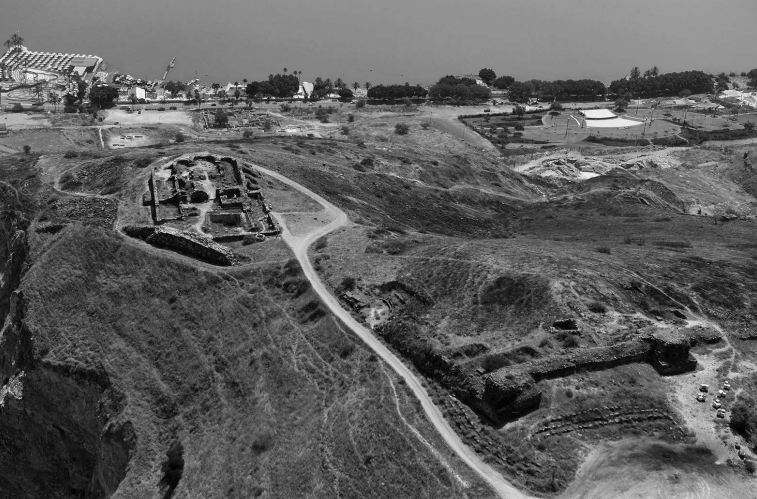 Figure C
Remains of Byzantine wall and “Anchor Church” on top of Mount Berenice, overlooking the Sea of Galilee. Photo by David Silverman.
Cytryn-Silverman (2015) - Aerial View of Mount
Berineke (wide shot) from biblewalks.com
 Aerial View of Mount Berineke (wide shot)
In this aerial view the Byzantine wall is seen in the foreground, with twin towers that protected the western side. Each tower is 7.5m square, once reaching a height of 15m.
click on image to open a high res magnifiable version of this photo in a new tab
Used with permission from BibleWalks.com - Aerial View of the church
on Mount Berineke from biblewalks.com
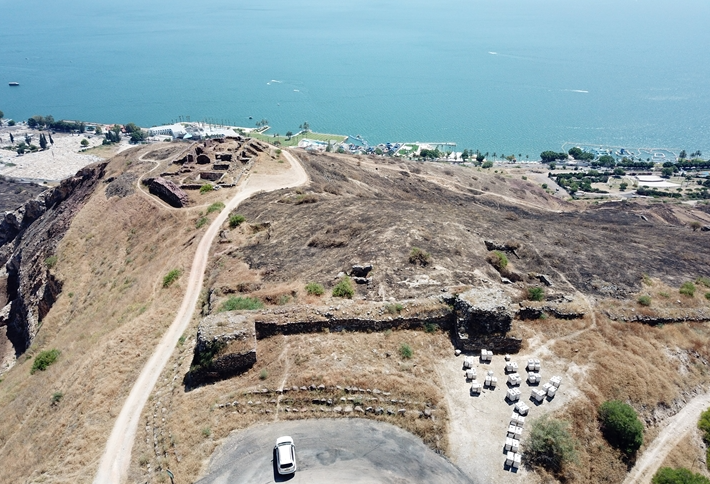
 Aerial View of the church on Mount Berineke
click on image to open a high res magnifiable version of this photo in a new tab
Used with permission from BibleWalks.com - Mount Berineke in Google Earth
 Mount Berineke
click on image to explore this site on a new tab in Google Earth - Mount Berineke on govmap.gov.il
 Mount Berineke
click on image to explore this site on a new tab in govmap.gov.il

- Fig. C Remains of Byzantine
wall and “Anchor Church” on top of Mount Berenice from Cytryn-Silverman (2015)
Figure C
Remains of Byzantine wall and “Anchor Church” on top of Mount Berenice, overlooking the Sea of Galilee. Photo by David Silverman.
Cytryn-Silverman (2015) - Aerial View of Mount
Berineke (wide shot) from biblewalks.com
Aerial View of Mount Berineke (wide shot)
In this aerial view the Byzantine wall is seen in the foreground, with twin towers that protected the western side. Each tower is 7.5m square, once reaching a height of 15m.
click on image to open a high res magnifiable version of this photo in a new tab
Used with permission from BibleWalks.com - Aerial View of the church
on Mount Berineke from biblewalks.com
Aerial View of the church on Mount Berineke
click on image to open a high res magnifiable version of this photo in a new tab
Used with permission from BibleWalks.com - Mount Berineke in Google Earth
Mount Berineke
click on image to explore this site on a new tab in Google Earth - Mount Berineke on govmap.gov.il
Mount Berineke
click on image to explore this site on a new tab in govmap.gov.il
- Plan of church on top of
Mount Berineke modified by JW from Ferrario et al (2014)
 Figure 13
Preliminary sketch of the Berniki church with observed deformations.
redrawn by JW
Ferrario et al (2014) - Fig. 1 Plan of church on
top of Mount Berineke from Hirschfeld (1994)
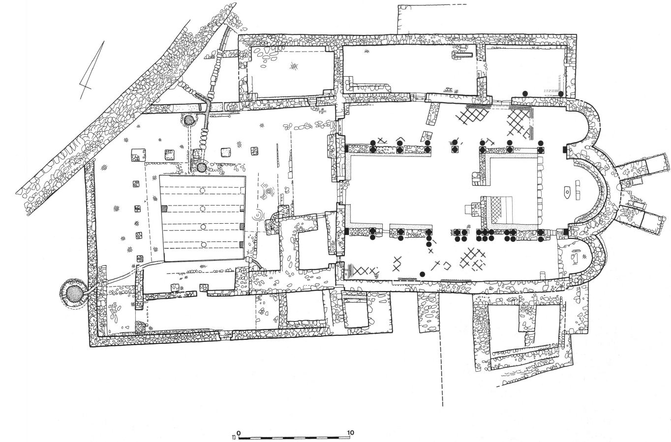 Figure 1
Plan of church on top of Mount Berineke
Hirschfeld (1994) - Fig. 6 3D reconstruction
of church on top of Mount Berineke from Hirschfeld (1993)
 Figure 6
3D reconstruction of church on top of Mount Berineke
Hirschfeld (1993)
- Fig. 1 Plan of church on
top of Mount Berineke from Hirschfeld (1994)
Figure 1
Plan of church on top of Mount Berineke
Hirschfeld (1994)
| Effect | Location | Image(s) | Description |
|---|---|---|---|
| Collapsed wall | partition wall between the atrium and the narthex
Figure 1 Plan of church on top of Mount Berineke Hirschfeld (1994) |
|
|
| Construction of buttress walls suggesting wall tilting, displacement, or folding | eastern and southern outer walls
Figure 1 Plan of church on top of Mount Berineke Hirschfeld (1994) |
|
|
| Repairs | various locations
Figure 1 Plan of church on top of Mount Berineke Hirschfeld (1994) |
|
- from Ferrario et al (2014)
-
Ferrario et al (2014) noted that
The church remains at Mt. Berenice show two different building techniques (different building-stone sizes, cement between building-stones). Several fractures are visible; some of them seem a result of building decay or different techniques, or are related to part of the building added later or to weaker structural elements (e.g. arches). Some other fractures, indeed, can be explained only with the occurrence of an external event (e.g. earthquake, landslide, geotechnical failure)
| Site | Plan | Image | Description |
|---|---|---|---|
| A |
Figure 13 Preliminary sketch of the Berniki church with observed deformations. redrawn by JW Ferrario et al (2014) |
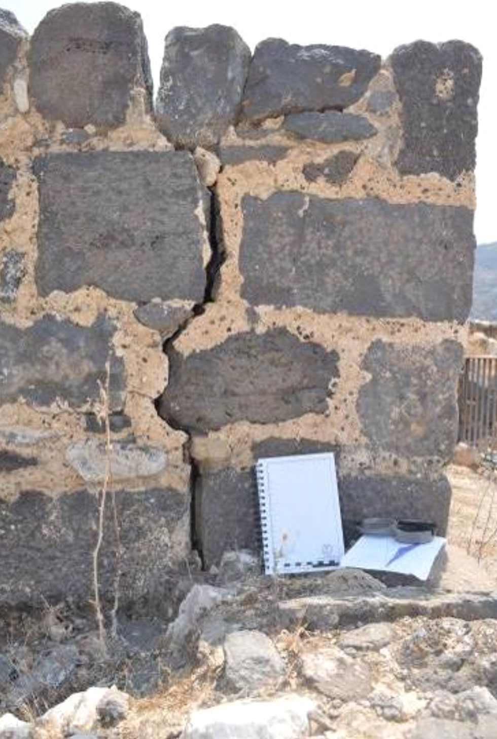 Figure 14: Deformation observed at the Berniki church (Site A).
Ferrario et al (2014) |
This is probably the clearest evidence of an external event. Fracture on a 1 m high wall; the fracture covers all the wall's height. Open fracture, 3-4 cm between the 2 sides, ca. 2 cm of left displacement. The W side is vertical, the E side shows an arcuate (concave N-ward) style (Fig. 14). |
| B |
Figure 13 Preliminary sketch of the Berniki church with observed deformations. redrawn by JW Ferrario et al (2014) |
Fracture on a 70 cm high wall; the prosecution is visible for ca. 50 cm in the superior part of the wall; no lateral displacement. | |
| C |
Figure 13 Preliminary sketch of the Berniki church with observed deformations. redrawn by JW Ferrario et al (2014) |
 Figure 15: Deformation observed at the Berniki church (Site C).
Ferrario et al (2014) |
Vertical fracture on a 2.40 m high wall; the fracture is visible only in the lower 1.60 m. Spacing between the 2 sides ca. 1 cm, no lateral displacement. The wall for its entire length seems built with 2 different techniques: lower part with much more cement and smaller boulders. The fracture ends ca. at the boundary between the 2. A, B and C are aligned along the N150° direction (Fig 15). |
| D |
Figure 13 Preliminary sketch of the Berniki church with observed deformations. redrawn by JW Ferrario et al (2014) |
Here the features (vertical fractures) seems related to different building phases (presence/absence cement). | |
| E & F |
Figure 13 Preliminary sketch of the Berniki church with observed deformations. redrawn by JW Ferrario et al (2014) |
Tilting and dislocation of 2 walls (loss of verticality), but related to weaker structural elements (arches). | |
| G |
Figure 13 Preliminary sketch of the Berniki church with observed deformations. redrawn by JW Ferrario et al (2014) |
Single stone located at the base of a door, fractured in 2 blocks. | |
| H |
Figure 13 Preliminary sketch of the Berniki church with observed deformations. redrawn by JW Ferrario et al (2014) |
Series of sub-vertical fractures, in correspondence to a corner in the wall; up to 4-5 cm between the 2 sides. Possible 1-2 cm of right-lateral displacement. In one point, the fracture broke a 20 cm long single stone. | |
| I |
Figure 13 Preliminary sketch of the Berniki church with observed deformations. redrawn by JW Ferrario et al (2014) |
Fractures in a 2.5 m high wall; several stones broken, up to 1 cm between the 2 sides, no lateral displacement. |
Figure 13Preliminary sketch of the Berniki church with observed deformations.
redrawn by JW
Ferrario et al (2014)
- Deformation Map modified by JW from Fig. 1 of Hirschfeld (1994)
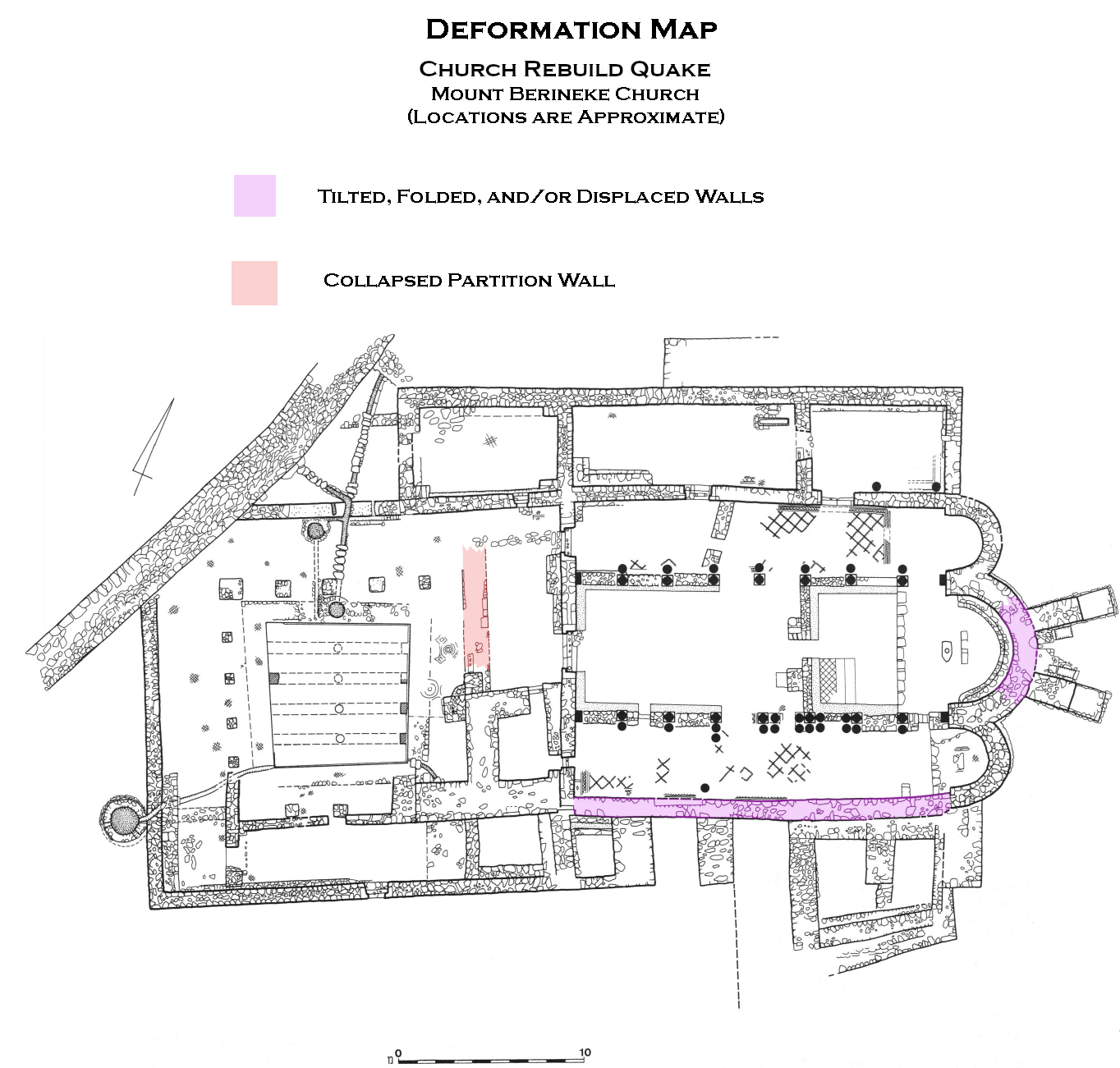 Deformation Map
click on image to open in a new tab
Modified by JW from Fig. 1 of Hirschfeld (1994)
- Deformation Map modified by JW from Fig. 1 of Hirschfeld (1994)
- derived from archaeoseismic survey in Ferrario et al (2014)
 Deformation Map
click on image to open in a new tab
Modified by JW from Fig. 1 of Hirschfeld (1994)
- Earthquake Archeological Effects chart
of Rodríguez-Pascua et al (2013: 221-224)
 Earthquake Archeological Effects (EAE)
Rodríguez-Pascua et al (2013: 221-224)
| Effect | Location | Image(s) | Description | Intensity |
|---|---|---|---|---|
| Collapsed wall | partition wall between the atrium and the narthex
Figure 1 Plan of church on top of Mount Berineke Hirschfeld (1994) |
|
VIII + | |
| Construction of buttress walls suggesting wall tilting, displacement, or folding | eastern and southern outer walls
Figure 1 Plan of church on top of Mount Berineke Hirschfeld (1994) |
|
VI + or VII + |