Jerash - Northwest Quarter
 Jerash Northwest Quarter
click on image to explore this site on a new tab in Google Earth
- Jerash Northwest Quarter in Google Earth
Jerash Northwest Quarter
click on image to explore this site on a new tab in Google Earth
- General Plan of Jerash
from Wikipedia
- Fig. 1 - Plan of Jerash
showing location of Northwest Quarter - from Daugbjerg et al (2022)
 Fig. 1
Maps of the Northwest Quarter, ancient Jerash and the Middle East.
(Maps credit: Danish-German Jerash Northwest Quarter Project).
Daugbjerg et al (2022)

- Fig. 1 - Plan of Jerash
showing location of Northwest Quarter - from Daugbjerg et al (2022)
Fig. 1
Maps of the Northwest Quarter, ancient Jerash and the Middle East.
(Maps credit: Danish-German Jerash Northwest Quarter Project).
Daugbjerg et al (2022)
- Fig. 9 - Northwest Quarter of Jerash
from Lichtenberger (2016)
 Fig. 9
Plan of the Northwest Quarter of Jarash
Lichtenberger (2016) - Fig. 2 - Northwest Quarter of Jerash
from Lichtenberger and Raja (2022)
 Fig. 2
Map of the Northwest Quarter
© Danish-German Jerash Northwest Quarter Project
Lichtenberger and Raja (2022) - Fig. 1 - Northwest Quarter of Jerash
from Kalaitzoglou et al (2022)
 Fig. 1
Plan of the Northwest Quarter with Trenches A-X (2012-2016).
Kalaitzoglou et al (2022)
- Fig. 9 - Northwest Quarter
of Jerash from Lichtenberger (2016)
Fig. 9
Plan of the Northwest Quarter of Jarash
Lichtenberger (2016) - Fig. 2 - Northwest Quarter
of Jerash from Lichtenberger and Raja (2022)
Fig. 2
Map of the Northwest Quarter
© Danish-German Jerash Northwest Quarter Project
Lichtenberger and Raja (2022) - Fig. 1 - Northwest Quarter
of Jerash from Kalaitzoglou et al (2022)
Fig. 1
Plan of the Northwest Quarter with Trenches A-X (2012-2016).
Kalaitzoglou et al (2022)
- Fig. 5 - Areas B, C, D, and E
from Lichtenberger and Raja (2016)
 Fig. 5
Plan of the Hamlet (Danish-German Northwest Quarter Project).
Lichtenberger and Raja (2016)
- Fig. 5 - Areas B, C, D, and E
from Lichtenberger and Raja (2016)
Fig. 5
Plan of the Hamlet (Danish-German Northwest Quarter Project).
Lichtenberger and Raja (2016)
- Fig. 5.10 Plan of the
Synagogue Church from Lichtenberger and Raja (2025)
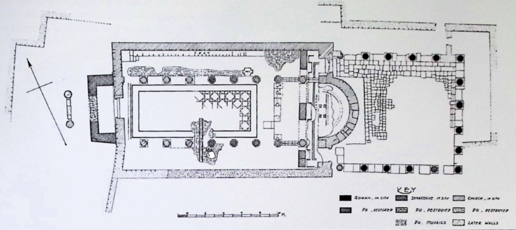 Figure 5.10
Plan of the Synagogue Church
(Kraeling, 1938)
Click on image to open in a new tab
Lichtenberger and Raja (2025) - Fig. 5.11 Plan of the
Synagogue Church and the Mosaic Hall north of it from Lichtenberger and Raja (2025)
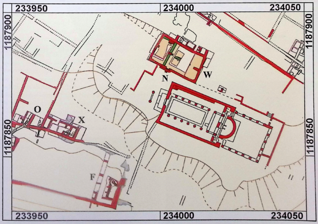 Figure 5.11
State Plan of the Synagogue Church and the Mosaic Hall north of it
(the Danish-German Jerash Northwest Quarter Project)
Click on image to open in a new tab
Lichtenberger and Raja (2025) - Fig. 2 Phase plan of
the 'Synagogue Church' from Lichtenberger Raja (2018b)
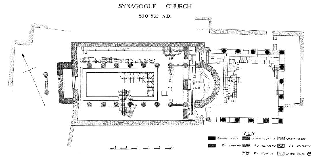 Figure 2
Phase plan of the 'Synagogue Church'
Click on image to open in a new tab
Lichtenberger Raja (2018b) - Fig. 3 Plan of the
Synagogue from Lichtenberger Raja (2018b)
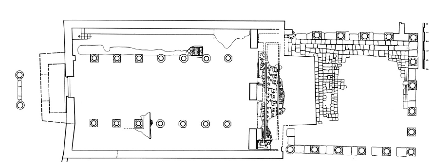 Figure 3
Plan of the Synagogue
Click on image to open in a new tab
Lichtenberger Raja (2018b) - Fig. 4 Plan of the
'Synagogue Church' from Lichtenberger Raja (2018b)
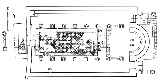 Figure 4
Plan of the 'Synagogue Church'
Click on image to open in a new tab
Lichtenberger Raja (2018b)
- Fig. 5.10 Plan of the
Synagogue Church from Lichtenberger and Raja (2025)
Figure 5.10
Plan of the Synagogue Church
(Kraeling, 1938)
Click on image to open in a new tab
Lichtenberger and Raja (2025) - Fig. 5.11 Plan of the
Synagogue Church and the Mosaic Hall north of it from Lichtenberger and Raja (2025)
Figure 5.11
State Plan of the Synagogue Church and the Mosaic Hall north of it
(the Danish-German Jerash Northwest Quarter Project)
Click on image to open in a new tab
Lichtenberger and Raja (2025) - Fig. 2 Phase plan of
the 'Synagogue Church' from Lichtenberger Raja (2018b)
Figure 2
Phase plan of the 'Synagogue Church'
Click on image to open in a new tab
Lichtenberger Raja (2018b) - Fig. 3 Plan of the
Synagogue from Lichtenberger Raja (2018b)
Figure 3
Plan of the Synagogue
Click on image to open in a new tab
Lichtenberger Raja (2018b) - Fig. 4 Plan of the
'Synagogue Church' from Lichtenberger Raja (2018b)
Figure 4
Plan of the 'Synagogue Church'
Click on image to open in a new tab
Lichtenberger Raja (2018b)
- Fig. 5.9 The excavated
Synagogue Church from Lichtenberger and Raja (2025)
 Figure 5.9
Photograph of the excavated Synagogue Church
(courtesy of Yale University Art Gallery (YUAG))
Click on image to open in a new tab
Lichtenberger and Raja (2025) - Fig. 3.38b Synagogue Church (?)
during excavation showing the orientation of fallen columns from Boyer (2022)
 Figure 3.38b
Photographs of the basilica of St Theodore's Church during excavation showing the orientation of fallen columns
JW: This may in fact be from the Synagogue Church as seems to be indicated in the narraive text by Boryer (2022)
London, UCL, StTheodore_23_1441 3273846_98ed97777f o.jpg. UCL, Institute of Archaeology
Click on image to open in a new tab
Boyer (2022)
- Fig. 5.9 The excavated
Synagogue Church from Lichtenberger and Raja (2025)
Figure 5.9
Photograph of the excavated Synagogue Church
(courtesy of Yale University Art Gallery (YUAG))
Click on image to open in a new tab
Lichtenberger and Raja (2025) - Fig. 3.38b Synagogue Church (?)
during excavation showing the orientation of fallen columns from Boyer (2022)
Figure 3.38b
Photographs of the basilica of St Theodore's Church during excavation showing the orientation of fallen columns
JW: This may in fact be from the Synagogue Church as seems to be indicated in the narraive text by Boryer (2022)
London, UCL, StTheodore_23_1441 3273846_98ed97777f o.jpg. UCL, Institute of Archaeology
Click on image to open in a new tab
Boyer (2022)
 Fig. 7
Calibrated and modelled dates for the Umayyad house’s radiocarbon dates. Conclusive plaster dates from Table 1. Charcoal dates from Philippsen and Olsen (2020).
Daugbjerg et al (2022)
- General Plan of Jerash
from Wikipedia
- Fig. 1 - Plan of Jerash
showing location of Northwest Quarter - from Daugbjerg et al (2022)
Fig. 1
Maps of the Northwest Quarter, ancient Jerash and the Middle East.
(Maps credit: Danish-German Jerash Northwest Quarter Project).
Daugbjerg et al (2022)
- Fig. 1 - Plan of Jerash
showing location of Northwest Quarter - from Daugbjerg et al (2022)
Fig. 1
Maps of the Northwest Quarter, ancient Jerash and the Middle East.
(Maps credit: Danish-German Jerash Northwest Quarter Project).
Daugbjerg et al (2022)
- Fig. 9 - Northwest Quarter of Jerash
from Lichtenberger (2016)
Fig. 9
Plan of the Northwest Quarter of Jarash
Lichtenberger (2016) - Fig. 2 - Northwest Quarter of Jerash
from Lichtenberger and Raja (2022)
Fig. 2
Map of the Northwest Quarter
© Danish-German Jerash Northwest Quarter Project
Lichtenberger and Raja (2022) - Fig. 1 - Northwest Quarter of Jerash
from Kalaitzoglou et al (2022)
Fig. 1
Plan of the Northwest Quarter with Trenches A-X (2012-2016).
Kalaitzoglou et al (2022)
- Fig. 9 - Northwest Quarter
of Jerash from Lichtenberger (2016)
Fig. 9
Plan of the Northwest Quarter of Jarash
Lichtenberger (2016) - Fig. 2 - Northwest Quarter
of Jerash from Lichtenberger and Raja (2022)
Fig. 2
Map of the Northwest Quarter
© Danish-German Jerash Northwest Quarter Project
Lichtenberger and Raja (2022) - Fig. 1 - Northwest Quarter
of Jerash from Kalaitzoglou et al (2022)
Fig. 1
Plan of the Northwest Quarter with Trenches A-X (2012-2016).
Kalaitzoglou et al (2022)
Fig. 7Calibrated and modelled dates for the Umayyad house’s radiocarbon dates. Conclusive plaster dates from Table 1. Charcoal dates from Philippsen and Olsen (2020).
Daugbjerg et al (2022)
- Photogram of Trench K
from Lichtenberger et al. (2021:28-29)
 A photogram showing the excavated parts of the House of the Scroll (Trench K).
The kitchen is the room in the SW corner. Marked in white (no. 23) is the place where a coin hoard was found.
A photogram showing the excavated parts of the House of the Scroll (Trench K).
The kitchen is the room in the SW corner. Marked in white (no. 23) is the place where a coin hoard was found.
Lichtenberger et al. (2021)
The excavators came across several sturdy walls in Trench K, all running either northwest-southeast or northeast-southwest. Understanding what structure the walls belonged to required carefully digging through 1.5 to 2m of debris: debris that contained vessels, lamps, coins, beads, spindle whorls, metal tools, and chunks of tumbled wall, painted wall plaster and stucco profiles, and much more. lt soon became clear that the debris layer must be the collapsed upper storey of the structure under excavation. A silver scroll in a lead container was also found among the rubble, gifting the building its modern name: 'House of the Scroll'. Below this find-rich collapse deposit lay a loose brownish soil, which turned out to be decayed woodwork from the former ceiling of the lower storey.
lt was only when the excavation team reached the ground-floor rooms that they finally established what sort of structure they were dealing with. The hearth, together with the various types of pots nearby, revealed the presence of a kitchen belonging to a private house. What is more, based on the finds, the lavish decoration, and the size of the house (although the whole structure has not been excavated), it was clear that this residence belonged to a wealthy family. This was not just a trophy property, though, as it was also a place of work. One of the occupations undertaken by the inhabitants was clearly evidenced by the numerous instruments associated with the textile industry found in both the kitchen and the thick debris layer from the upper storey. Despite the age of Gerasa itself, the finds from the house are mainly of Umayyad date. They reveal that the house was most likely built during the early part of that era, before collapsing in the dying days of Umayyad rule. The neat fit between the finds, the collapsed masonry, and historical accounts of the earthquake is corroborated by radiocarbon dates of charcoal samples. lt is therefore safe to assume that the house was indeed destroyed by the AD 749 earthquake.
- Fig. 2 - Trench S excavated structures
from Kalaitzoglou et al (2022)
 Fig. 2
Trench S, excavated structures
Note by JW: Sector h (aka Sh) in the lower right
Kalaitzoglou et al (2022) - Fig. 3 - Trenches A and S plans
from Kalaitzoglou et al (2022)
 Fig. 3
Trenches A and S, Roman edifice and cistern with cooking-pot deposits.
Note by JW: Sector h (aka Sh) in the lower right
Kalaitzoglou et al (2022)
Kalaitzoglou et al (2022:141) report that a terrace wall (ev. 51a) in Sector h of Trench S (aka Sh) may have been built when a 70 m long rectangular building complex to the immediate SE (reflected in Trenches C, D, E, J, and T) was constructed during the Byzantine Period. Kalaitzoglou et al (2022:141) report that the building complex
was in use until the earthquake of 749 AD. No seismic effects are described for this terrace wall (ev. 51a) or for a subsequent wall face (ev. 51b) built during Umayyad times.
- Fig. 7 - Trench T excavated structures
from Kalaitzoglou et al (2022)
 Fig. 7
Trench T, excavated structures
Kalaitzoglou et al (2022)
Kalaitzoglou et al (2022:141) examined Trench T which uncovered
the north-western corner of the so-called Ionic Building. The Ionic building's construction was dated to Middle Islamic times but was built atop an earlier Byzantine complex which Kalaitzoglou et al (2022:142) state was
partly reused in the Umayyad period and [] destroyed by the earthquake of 749 AD. Kalaitzoglou et al (2022:144) described evidence for earthquake destruction in Trench T which was dated to 749 CE. The dating was characterized as likely. The subsequent building Phase 3 was estimated to have taken place
several hundred yearslater.
Building Phase 1 (Byzantine to Umayyad)
... no finds were related to this first building phase, but the condition of the walls and the alterations and overlying layers prove that this building complex was in use until it was destroyed by a heavy earthquake, probably the earthquake of 749 AD.
Building Phase 2 and Earthquake Destruction (Umayyad)
... This building phase was destroyed by an earthquake. This explains why the walls are in bad condition and bulging in a south-eastern direction. The thin soil layer (ev. 75) covering the floor (ev. 76) contained a mixture of fragmented pottery sherds ranging from Roman to Byzantine/Early Umayyad date, including an imported Late Roman C bowl of 5th century production (Pl. 4.30), late Byzantine/Early Umayyad basins (Pls. 5.36 and 6.41) and two intact Jarash lamps of 6th/early 7th century production (Pls. 16.89 and 17.92). The late Byzantine to Umayyad date seems to correlate with the finds from the thick debris layer (ev. 72) of compact yellowish soil (ev. 72) and tumbled stones (ev. 80). In this undisturbed debris layer, fragments of tableware, cooking and common ware, and transport vessels were found, all Umayyad production. It is therefore likely that this part of the building was destroyed in the earthquake of 749 AD.
Building Phase 3 (1st Middle Islamic Phase)
Several hundred years after the earthquake, a large square courtyard house (the Ionic Building) was constructed over the ruins.
- Fig. 10 - Trench U excavated structures
from Kalaitzoglou et al (2022)
 Fig. 10
Trench U, excavated structures
Kalaitzoglou et al (2022)
Kalaitzoglou et al (2022:148-153) described evidence for rapid earthquake destruction immediately above Phase 4 of Trench U. Seismic destruction was dated
probablyto 749 CE. A terminus post quem of 705 CE can be established for the seismic destruction as an Umayyad post-reform Fals coin dated to 705-717 CE was found associated Phase 4. Other dating evidence came from pottery, tiles, stone objects, metal finds, coins and radiocarbon. There was no subsequent overlying building phase to establish a terminus ante quem.
Open Quarry Work
Like in other trenches, especially on top of the hill, the walls were built on top of bedrockcut walls or in areas where the bedrock had been levelled (Kalaitzoglou, Lichtenberger and Raja 2013; 2017). These rock dressings obviously belonged to an older stone quarry situated here, since they predate the construction of the house.
Building Phase 1 (Early Umayyad)
In the first building phase, most probably only the core building was established. ... A date for the construction of the core building is given by the foundation fill (ev. 45). ... If this Umayyad backfill (ev. 45) is not the restoration of an older fill, the building complex must have been constructed in (early?) Umayyad times.
Building Phase 2 (Umayyad)
In this phase, the long rectangular east room was built from the east against the core building. Although only the southern half of the room was fully excavated and, in the northern half, only the surface was cleaned, it is evident that the room was north–south oriented and measured 7.6m by 3.5m. ... A precise dating of the second Umayyad building phase and the construction of the east room is not possible, since only very few finds were associated with the foundation layers and the floor.
Building Phase 3 (Umayyad)
In this phase, the floor level inside the east room was raised. ... In the foundation fill (ev. 56), small and worn fragments of Byzantine and Early Umayyad pottery were found. ... it is possible to conclude that the third phase is an Umayyad phase, postdating relatively the earlier Umayyad phases.
Building phase 4 (Umayyad)
In the fourth building phase, large-scale alterations took place. ... Since most of the contexts yielded no finds, dating the last building phase has to rely on the walk-on level in the former east room. Only very few pottery sherds were embedded into the foundation fill (ev. 51), of which the youngest were of Umayyad date. However, an Umayyad post-reform Fals, found in the same context, proves that the fourth building phase has to be dated to the first half of the 8th century AD [J16- Ud-51-1x. It is an Umayyad post-reform al-Walid I (705-717AD) Fals of 20 Qīrāt, minted in Tabariyya].
Earthquake Destruction (Umayyad, 749 AD)
It is obvious from the many destroyed objects found on the floor that the destruction of the building complex happened suddenly (see Fig. 10). First, the coating of the walls (ev. 60 and 80) and the roof collapsed. The thick layer of yellowish soil (ev. 23) as well as the embedded stone drum or roller (ev. 39) attest that the house had a flat roof. Since the roller (ev. 39) was found sticking vertically out of the yellowish soil of the collapsed roof, it is obvious that, like in modern times, the stone roller stayed on the flat roof and was used to compact it. In the lowermost collapse layer (ev. 60), fragments of an almost complete chimney were found (Pl. 19.107). The same layer covered the crushed fragments of a cooking pot and an amphora (ev. 71) of Umayyad date (Pls. 2.10 and 11.65) lying in front of the wall (ev. 7). In front of the opposite south wall (ev. 8), a large broken Grey Ware basin (ev. 74 (Pl. 7.44)) was found and, next to it, an assemblage (ev. 73) consisting of a short stone drum (J16-Uc-60-4x) and a broken marble slab with round moulding, both lying on a suspensura brick. Close to the centre of the room, a thin marble slab (ev. 75), broken into two, was found, as well as a worked piece of limestone with round carving (ev. 72), which had fallen from the roof, as evidenced by it being stuck in the roof collapse (ev. 23).
A date for the destruction of the core of the building is given by various evidences. In addition to pottery (Pls. 3.22, 4.32, 8.51 and 11.60), tiles (Pl. 19.107), stone objects (Pl. 21.117; Pl. 22.123 and 125) and metal finds (Pl. 23.141) that were covered and sealed by the first layer of destruction debris (ev. 60 and ev. 80), coins and radiocarbon samples are available. In the collapsed layer (ev. 60), both an Umayyad prereform Fals as well as an Umayyad post-reform Fals were found [J16-Uc-60-13x is an Umayyad pre-reform fals of phase 2, minted in Skythopolis. J16-Uc-60-6x is an Umayyad post-reform fals, of which only the Shahada is readable]. Well-preserved vessels found in situ (Pls. 4.33, 5.34 and 12.67) also date to the Umayyad period. Two charcoal samples taken from the soil of the collapsed platform roof date to the later 6th and mid 7th century AD respectively
- Sample no. 25898 (J16-Uc-23-22)
- Department of Physics and Astronomy, Aarhus University (Denmark)
- 14C age 1485 ± 49 BP
- δ13C (AMS) - 30.00 ± 1.00
- Calibration curve IntCal13
- 1σ 542-637 AD
- 2σ 429-652 AD (429-494 AD, 15.8%; 509-518 AD, 1.4%; 528-652 AD, 78.2%)
It is therefore possible that the collapsed roof of the core building (or at least its wooden beams) stem from the original building process.
- Sample no. 25897 (J16-Uc-23-28)
- Department of Physics and Astronomy, Aarhus University (Denmark)
- 14C age 1382 ± 34 BP
- δ13C (AMS) - 21.00 ± 1.00
- Calibration curve IntCal13
- 1σ 625-669 AD
- 2σ 599-689 AD
Both the north-west room and the south room of the core building, as well as the north room, were covered by a thick layer of collapsed stones (ev. 10 and 30). In contrast, the east room was covered by fewer stones (ev. 2), and in the inside the east room, above the last walk-on level (ev. 51), two thin, succeeding soil layers were unearthed (ev. 11 covered by ev. 12). The youngest coin found in ev. 11 is an Umayyad post-reform Fals [J16-Ud-11-12]. Combining the available evidence, a date in the 8th century AD is most probable for the destruction of the building complex. Since there is no evidence predating the mid 8th century AD, it is likely that the destruction of the building was related with the earthquake of 749 AD. There is no evidence for later occupation of this area.
- Fig. 1 - Northwest Quarter of Jerash
from Kalaitzoglou et al (2022)
Fig. 1
Plan of the Northwest Quarter with Trenches A-X (2012-2016).
Kalaitzoglou et al (2022) - Fig. 12 - Trench V excavated structures
from Kalaitzoglou et al (2022)
 Fig. 12
Trench V, excavated structures
Note by JW: Skeleton is marked by ev.45 in white text and ev.74 in black text. Both are located in the entrance corridor about 2/3 of the way down from the top and about 2/3 of the way from the left of this orthomosaic photo.
Kalaitzoglou et al (2022) - Fig. 13 - Trenches P and V plans
from Kalaitzoglou et al (2022)
 Fig. 13
Trenches P (2015) and V (2016), reconstruction of the Umayyad residence.
Kalaitzoglou et al (2022) - Fig. 15 - Skeleton
from Kalaitzoglou et al (2022)
 Fig. 15
Kalaitzoglou et al (2022)
Clear evidence of catastrophic destruction, likely due to an earthquake, was found in Trench V - as reported by Kalaitzoglou et al (2022:153-163). A skeleton, probably young and female, with
completely fracturedbones, apparently from structural collapse of
heavy stones, was found along with stone tumble, debris, and collapsed architectural elements (walls, columns, and roofing). There were multiple indications that a two storey structure collapsed. Dating was based on coins, pottery, and radiocarbon. An overlying building phase was not reported.
With Trench V the exploration of the Umayyad complexes on the so-called East Terrace of the hill was continued (see Figs. 1 and 12) (cf. Kalaitzoglou, Lichtenberger and Raja in press; Kalaitzoglou et al. in press) ... The Umayyad building has three main building phases with sub-phases. Before the edifice was constructed, the Central Street ran where the entrance portico later stood, and south of the street building complexes were situated. Most of the extant structures were erected in the first phase and underwent only minor changes in the later phases. In the second phase, the portico was extended to the west, and in the last building phase only a few floor levels within the building were renewed.
Building Phase 1 (Byzantine)
The oldest structures detected were the walls (ev. 66a and 66c) south of the Umayyad building (see Fig. 12). ... The evidence for dating this phase is sparse and relies on the finds from the foundation layer (ev. 106) of the street.
Building Phase 2a (Umayyad)
Major construction took place in this area in Umayyad times. It includes the founding of the large rectangular edifice north of the Central Street. The results of the previous excavation season showed that the edifice was founded in Umayyad times, and since all newly excavated walls bind into this complex, it is clear that they also belong to the same construction project.
... West of the entrance corridor two parallel basement rooms were excavated: the so-called Arched Room of about 6.20 m2 between the walls ev. 17 and ev. 7/24, spanned by a well preserved arch (ev. 27), and the so-called Western Basement Room taking up 10.60m2 between the walls ev. 7 and ev. 22. The Arched Room was accessible only from the courtyard. From the door ev. 77, a staircase (ev. 85) led down to a paved floor. The pavement west of the staircase (ev. 110) was made of thinner stone slabs, while the pavement (ev. 120) south of the staircase consisted of flattened stones set into a soil bedding. Behind the entrance, a small side chamber was situated west of the staircase. This chamber measured 0.9 by 1.2 m and was enclosed by the walls ev. 4, 24, 70 and 71. It is obvious that a narrow entrance was located in the east wall (ev. 71), but the opening was almost completely destroyed by the 749 AD earthquake.
... The Western Basement Room did not have access to the courtyard, and it was probably not covered by the intermediate floor like the Eastern Basement Room. The room is delimited to the south by the wall ev. 12/81, to the east by the diagonal wall ev. 7, to the west by the wall ev. 22 and to the north by the wall ev. 70. Like the Arched Room, it was of trapezoid shape and measured about 5.40m in length; its maximum width was more than 2.10m. The width is only approximate since the west wall (ev. 22) was not excavated. This wall was badly damaged by the earthquake in 749 AD. It leaned so far to the east that further excavation would have destabilized it, and it was therefore left unexcavated.
... The dating evidence for the construction of the edifice is sparse since almost no datable objects were found in the foundation fills.
Building Phase 2b (Umayyad)
At some point a repair of the western face of the wall (ev. 18) inside the entrance corridor was undertaken (see Fig. 12). ... A dating of this subphase is difficult since it is an isolated alteration, not physically linked with other datable contexts, and the foundation fills contained only few undiagnostic pottery sherds. A position in the stratigraphic sequence is indicated by the fact that the pavement (ev. 75) was the last floor laid in the corridor prior to the destruction caused by the 749AD earthquake.
Building Phase 3 (Umayyad)
The main feature of the third building phase was the extension of the portico in a westerly direction to create a space including a benchlike construction (ev. 32). ... Since the main deposits of this phase did not generate finds for dating we have to rely on the scanty finds from the fill (ev. 112) and the new street surface (ev. 102). In addition to some tesserae and a tile fragment from ev. 102, small and worn sherds of Umayyad pottery were found in both deposits.
Building Phase 4 (Umayyad)
The last phase was characterized by the installation of simple soil floors as walk-on levels in several parts of the building. This is apparently typical for the last Umayyad building phases, and was also encountered in Trenches K and P (Kalaitzoglou, Lichtenberger and Raja in press); Kalaitzoglou et al. in press; Lichtenberger et al. 2017). This feature allows us to unite separate building activities in one phase. During this phase also the backfilling of the entire Western Basement Room and the creation of a raised floor level happened.
... The archaeological evidence for the installation of the last floor levels before the destruction of the building suggests a date in the later Umayyad period. The floor foundation (ev. 86) in the Arched Room contained, aside from the tesserae and mortar concentration (ev. 95), only Late Umayyad pottery. Also the 14C date of a charcoal sample does not contradict such a dating
It is therefore possible that the new floor was installed shortly before the earthquake of 749 AD destroyed the edifice.
- Sample no. 25883 (J16-Vdf-86-1)
- Department for Physics and Astronomy, Aarhus University (Denmark)
- 14C age 1218 ± 62 BP
- δ13C (AMS) - 25.0 0± 2.00
- Calibration curve IntCal13
- 1σ 711-886 AD (711-745 AD, 13.8%; 764-886 AD, 54.4%)
- 2σ 670-962 AD (670-902 AD, 88.4%; 920-962 AD, 7.0%)
... The dating evidence for the closure of the Western Basement Room cannot be supported by radiocarbon dates or coins. In layer ev. 84 large amounts of Umayyad pottery were found and the same holds for the covering layer ev. 64.
... The finds from the fill (ev. 111) in the compartment outside the building are not distinctive. Although the full spectrum of functional groups is present, as well as Jarash Lamps and also some tesserae and tile fragments, only a general dating to the Late Byzantine to Umayyad periods is possible.
The Earthquake Destruction of the Umayyad Building
It is clear that the building was destroyed in a catastrophic event. All evidence suggests that this was the earthquake of 749 AD. A human skeleton was recovered in the destruction layers of the entrance corridor. The remains of a young person (ev. 45) were found 0.40-0.30m above the step ev. 74 (see Fig. 12). First appeared some skull fragments followed by an upper arm and a jaw jutting out from the compressed soil of the collapsed roofing and upper storey (ev. 44/60) between large blocks of collapsed stones (ev. 14) (Fig. 15). It is obvious that the body was completely fractured by the heavy stones, which tumbled during the earthquake. The position and dry condition of the human remains required a cautious excavation before the bones could be documented in situ. However, during the night an illicit excavation took place, and the bones together with the find context (ev. 55) were vandalized. Afterwards only a few bone fragments were recovered from the dump (ev. 56) scattered around the find spot [The disturbed find context was called ev. 55 and the moved soil ev. 56]. At the spot where the human remains were initially encountered, an iron adze (J16-Vi-60-3x) (Pl. 22.132) was found at a deeper level above the threshold, which might have been amongst the personal belongings of the victim.
Most of the excavated rooms and areas were filled with at least two distinguishable portions of collapse and debris, a common feature for a building with more than one storey. The first collapse consisted of the wall linings, the underlays as well as the upper flooring mixed with wall-stones. The lower part of the Arched Room was filled with soil (ev. 73) and stones (ev. 29), while above the new floor level in the Western Basement Room more wall-stones (ev. 21 and 28) were found among the soil (ev. 20, 23 and 53). In the entrance corridor a layer of brownish soil (ev. 67) mixed with wall plaster was found covering the pavement, which obviously stems from the wall coating. Above this the hallway was completely filled with tumbled wall-stones (ev. 14) and collapsed soil and other building material (ev. 44, 60 and 69). The area in front of the building was then completely covered by the collapsed walls, columns and roofing (ev. 14 and 26).
The composition of the collapse deposits shows that the edifice had more than one storey and, furthermore, that the upper storeys were paved with mosaics and the walls coated with coloured plaster. Although a lot of roof-tile fragments were found in the debris they were too few and scattered all around to attest to a tiled roof. It is thus most likely that the edifice had a platform roof and that the tiles served as building material or as framing slabs or were used for other purposes such as for fire places. Concerning the find groups, some observations which give an insight into the assemblage available in the upper storey are to be mentioned. In the entrance-hall and on the street the pottery was much better preserved than in the basement rooms. This, on the one hand, attests that pottery was stored above the portico but on the other hand hints that preservation depends on the amount of debris that fell with the pottery. In the hallway pottery was not frequent but other find groups, such as tesserae or metal objects, were well attested and preserved. This makes it probable that the rooms above the hallway were more representative and did not serve as simple storerooms or kitchens.
Regarding the dating of the earthquake destruction, the excavation brings only limited new data. The identified coins are almost all from the Late Roman period. The only exception was an Umayyad pre-reform coin of phase 1 (J16-Vh-26-64; c. 638-680AD) [For the phases of Umayyad pre-reform coinage, see Schulze and Oddy 2012] found in the collapse (ev. 26) above the street. Umayyad pottery dominates in all collapse deposits. The collapse (ev. 49) on the street as well as an embedded concentration of sherds (ev. 50) contained large amounts of Umayyad pottery, which had fallen from the upper storey. In ev. 26 large amounts of Umayyad pottery were found: a Jarash Lamp (Pl. 17.91) and also metal finds, such as two fittings with hinge (Pl. 23.135-136), large amounts of tesserae, tesserae chips as well as mosaic fragments, pieces of mortar, 32 tile fragments, an antefix and an imbrex, and even a water pipe fragment and a suspensurium. Embedded into this collapse were concentrations of sherds (ev. 39-42), which all contained fragments of Umayyad vessels. Inside the hallway, the amount of Umayyad pottery decreased from the collapse (ev. 44) near the door in direction of the arch (ev. 68), while the amounts of tesserae and plaster remained the same and the number of small finds decreased. One arrowhead was among the finds (Pl. 23.146). From ev. 60 stem only a few sherds, however, of note is an adze or hoe made of iron (Pl. 22.132). In ev. 69, apart from an iron knife and various other well-preserved finds, cymbals and parts of a musical instrument (Pl. 23.142-144) were found. The layer (ev. 67), which covered the floor, contained a lot of tesserae and plaster but very few Umayyad sherds. A mix of Umayyad pottery and building material, especially tesserae, mosaic fragments and mortar, was also unearthed in the Arched Room’s destruction deposits (ev. 73, 25, 63 and 23). In ev. 23 and 25, some Byzantine to Late Byzantine sherds and two fragments of choir screens (Pl. 21.119) (a piece of a pilaster capital (Pl. 21.118) stems from ev. 73), a stone bead (Pl. 22.126) and a large knife (Pl. 22.131) were also found. The finds from the Western Basement Room show a similar composition, but storage jars of different sizes (Pl. 8.46-48, 9.54 and 10.55) and fragments of basalt vessels were also present.
Three radiocarbon dates are available for the dating of the destruction. Two stem from the collapse deposit (ev. 73) in the Arched Room. One gives the date 686-894 AD with 94.9% probability
and the other dates with 89.4% probability to 596-779 AD. Both dates are in accordance with the assumed destruction of the earthquake of 749 AD. The third date stems from the lowermost collapse layer (ev. 67) in the entrance corridor. The rather early date 579-668 AD can be regarded as a terminus post quem and the sample was probably taken from material considerably predating the destruction.
- Sample no. 25884 (J16- Vdf-73-24)
- Department for Physics and Astronomy, Aarhus University (Denmark)
- C14 age 1215 ± 39 BP
- ẟ13C (AMS) - 20.00 ± 2.00
- Calibration curve IntCal13
- 1σ 728-878 AD (728-737 AD, 5.0%; 769-878 AD, 63.2%)
- 2σ 686-937 AD (686-894 AD, 94.9%; 933-937 AD, 0.5%)
- Fig. 1 - Northwest Quarter of Jerash
from Kalaitzoglou et al (2022)
Fig. 1
Plan of the Northwest Quarter with Trenches A-X (2012-2016).
Kalaitzoglou et al (2022) - Fig. 16 - Trenches N and W - excavated structures
from Kalaitzoglou et al (2022)
 Fig. 16
Trenches N (2015) and W (2016), excavated structures of the Mosaic Hall
Note by JW: Folded mosaic floor and collapse of western wall are in upper left
Kalaitzoglou et al (2022) - Fig. 18 - Trench W, western sectors,
younger mosaic (ev. 57), and destruction of the west wall from Kalaitzoglou et al (2022)
 Fig. 18
Trench W, western sectors, younger mosaic (ev. 57) and destruction of the west wall (ev. 51/80), view from the north.
Kalaitzoglou et al (2022)
Kalaitzoglou et al (2022:168-169) attributed destruction evidence in Trench W to an earthquake in 749 CE. Wall collapse and folded pavement were attributed to seismic destruction.
With Trench W, the exploration of the so called Mosaic Hall, which was discovered in 2015, was continued. This hall was a side building to the Byzantine so-called Synagogue Church (cf. Fig. 1).
...
Aside from the Late Roman cave system, three major phases can be distinguished for the Mosaic Hall [For the results of the previous season, see Kalaitzoglou et al. in press]. In the first phase, the complex was constructed in front of the older caves, and the first mosaic floor, dated by an inscription to March 576AD, was laid. In the second phase, the hall was enlarged to the west, and this part was covered with a new mosaic which according to the inscription dates to July 591AD (Haensch, Lichtenberger and Raja 2016). Soundings in disturbed parts of both mosaics have shown that they are the only floors in the complex without earlier phases. A transformation of the long hall into smaller room units took place in the third phase, which can be dated to the Umayyad period. It was already clarified in 2015 that the hall was destroyed by the earthquake of 749 AD (Kalaitzoglou et al. in press).
The Phase before the Construction of the Mosaic Hall
Only limited evidence was found belonging to the phase before the construction of the Mosaic Hall.
Building Phase 1 (Byzantine, before 576 AD)
In its original layout, the Mosaic Hall was already roughly rectangular but shorter.
Building Phase 2 (Byzantine, before 591 AD)
In this phase the Mosaic Hall was extended for 5.00m in a westerly direction and was thus enlarged by some 26 m2.
...
A dating of the extension of the hall is provided only by the new mosaic inscription, which gives the year 591AD. Additional evidence is not available at the moment since the foundation fill (ev. 66) yielded no datable objects.
Building Phase 3 (Umayyad)
The Mosaic Hall was in use until the 749 AD earthquake. At the time of the Islamic conquest in 636 AD at the latest, we have to assume that the Byzantine military unit left Jarash and the building was reused for other purposes. In the Islamic period it was divided into smaller units.
...
The 2016 excavations provide little further dating evidence for the Umayyad phase. As in the last season, no coins were found on top of the floors and most of the other objects are older or not precisely datable. The youngest pottery embedded into the yellowish roof collapse (ev. 23/107 and 54) is of Early Umayyad to Umayyad date (Pls. 2.15 and 3.23), suggesting that the hall got a new flat roof in Umayyad times. A charcoal sample taken from the yellowish layer (ev. 54) is therefore too old since it gives the date 133-435 AD.
More conclusive and directly connected with the last use of the west room is a charcoal sample taken from the ash layer (ev. 74) covering the mosaic (ev. 57) in front of the bench. The radiocarbon date for this sample is with 86.9% probability 661-779 AD, making it likely that the earthquake responsible for the destruction is the one of 749 AD
- Sample no. 25869 (J16-Wik-54-10)
- Department of Physics and Astronomy, Aarhus University (Denmark)
- C14 age 1707 ± 72 BP
- δ13C (AMS) - 15.00 ± 3.00
- Calibration curve IntCal13
- 1σ 245-406 AD (245-406 AD, 68.2%)
- 2σ 133-534 AD (133-435 AD, 88.7%; 451-471 AD, 1.6%; 487-534 AD, 5.1%)
Phase 4 (Umayyad 749 AD, Earthquake Destruction).
- Sample no. 25868 (J16-Wk-200-1)
- Department of Physics and Astronomy, Aarhus University (Denmark)
- 14C age 1272 ± 36 BP
- δ13C (AMS) - 19.00 ± 1.00
- Calibration curve IntCal13
- 1σ 682-769 AD (682-73 0AD, 40.4%; 736-769 AD, 27.8%)
- 2σ 661-864 AD (661-779 AD, 86.9%; 791-828 AD, 5.0%; 838-864 AD, 3.5%)
After uncovering more mosaic areas in 2016, it became more and more apparent that during the earthquake destruction large parts of the mosaic sank down. This is evident especially in the western part of the hall (Fig. 18). There waves in the mosaic layer were caused by a compression of the soil under the mosaic. Therefore, the mosaic sunk where no substructures ran under it. Due to this fact we were able to identify a wall in the foundation covered by the mosaic and running from west to east in the line of the roof supports (ev. 67 and J15-N-13).
We are able to trace three succeeding phases in which the earthquake debris of the building was deposited. In the eastern sectors a-h the mosaic was covered by a layer of compact yellowish soil (ev. 23/107) that was also found in the western sectors i-l (ev. 54) [It is the same yellowish layer excavated already in 2015 and labelled with ev. J15-N-22, J15-N-28, J15-N-40 and J15-N-70]. In the west the yellowish soil layer partly surrounded the stone debris (ev. 56) of the Umayyad wall (ev. 79/J15-N-4) and covered also the bench (ev. 55) as well as the podium (ev. 75) with the stones (ev. 68) on top of it. This thick yellowish layer stems from the collapsed roof of compressed soil that was used during the Umayyad period, and which collapsed first. In the eastern part of the hall closer to the walls the collapsed brownish underlay of the wall linings (ev. 8) was found as well as the displaced core (ev. 110) of the collapsed eastern buttress (ev. 58/104). These first collapse deposits were covered by a layer of wall-stone debris (ev. 14/112, 21 and 56), which was surrounded by the soil of the wall cores (ev. 15 and 22). This debris stems from the upper-wall portions. In the next phase the remaining parts of the walls collapsed to a level to which they were stabilized by the debris. To this uppermost debris belong a stone collapse (ev. 11/111 and 50/52) and the surrounding soil (ev. 19 and 47) (cf. Fig. 18).
Agricultural Use and Destruction in Modern Times
After the earthquake, the Mosaic Hall was subject to further disturbances, which damaged the walls as well as the western entrance.
| Seismic Effect | Location | Image(s) | Description |
|---|---|---|---|
|
north-western corner of the so-called Ionic Building - Trench T
Fig. 2 Map of the Northwest Quarter © Danish-German Jerash Northwest Quarter Project Lichtenberger and Raja (2022) |
Fig. 7 Trench T, excavated structures Kalaitzoglou et al (2022) |
|
|
Trench U - a building north of the so-called South Street and connected to a long wall which is part of a residential complex
Fig. 2 Map of the Northwest Quarter © Danish-German Jerash Northwest Quarter Project Lichtenberger and Raja (2022) |
Fig. 10 Trench U, excavated structures Kalaitzoglou et al (2022) |
|
|
Umayyad Courtyard House on the East Terrace - Trenches V and P
Fig. 2 Map of the Northwest Quarter © Danish-German Jerash Northwest Quarter Project Lichtenberger and Raja (2022)
Fig. 13Trenches P (2015) and V (2016), reconstruction of the Umayyad residence. Kalaitzoglou et al (2022) |
Fig. 12 Trench V, excavated structures Note by JW: Skeleton is marked by ev.45 in white text and ev.74 in black text. Both are located in the entrance corridor about 2/3 of the way down from the top and about 2/3 of the way from the left of this orthomosaic photo. Kalaitzoglou et al (2022)
Fig. 15Skeleton Kalaitzoglou et al (2022) |
|
|
The so-called Mosaic Hall - Trench W
Fig. 2 Map of the Northwest Quarter © Danish-German Jerash Northwest Quarter Project Lichtenberger and Raja (2022) |
Fig. 16 Trenches N (2015) and W (2016), excavated structures of the Mosaic Hall Note by JW: Folded mosaic floor and collapse of western wall are in upper left Kalaitzoglou et al (2022)
Fig. 18Trench W, western sectors, younger mosaic (ev. 57) and destruction of the west wall (ev. 51/80), view from the north. Kalaitzoglou et al (2022) |
|
|
The "House of Scroll" - Trench K
Fig. 2 Map of the Northwest Quarter © Danish-German Jerash Northwest Quarter Project Lichtenberger and Raja (2022) |
A photogram showing the excavated parts of the House of the Scroll (Trench K).
The kitchen is the room in the SW corner. Marked in white (no. 23) is the place where a coin hoard was found.
Lichtenberger et al. (2021) |
|
- Modified by JW from Fig. 2 of Lichtenberger and Raja (2022), Fig. 7 of Kalaitzoglou et al (2022), Fig. 10 of Kalaitzoglou et al (2022), Fig. 12 of Kalaitzoglou et al (2022), Fig. 16 of Kalaitzoglou et al (2022), and Trench K photogram of Lichtenberger et al. (2021)
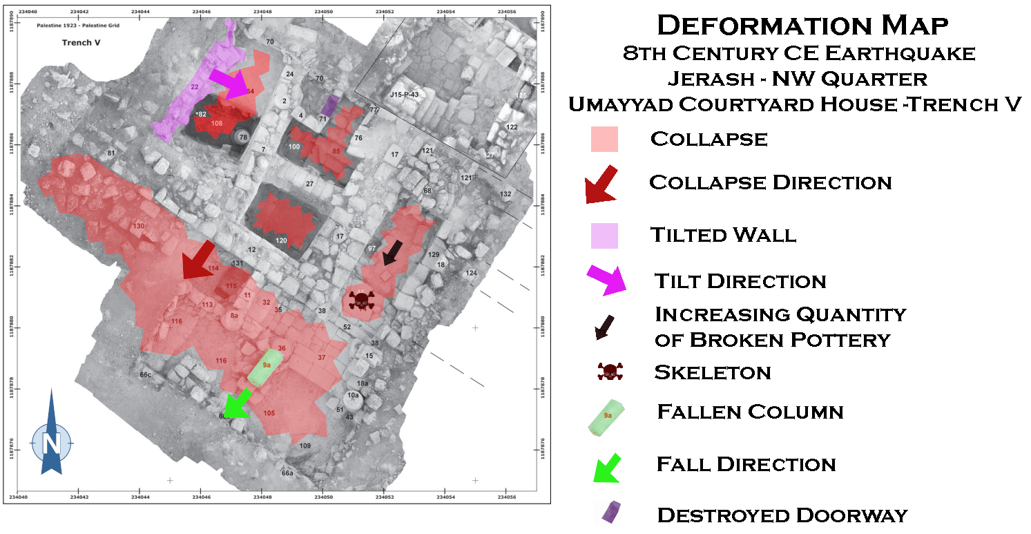
 Deformation Map
Click on image to open a higher res magnifiable image in a new tab
Modified by JW from Fig. 2 of Lichtenberger and Raja (2022), Fig. 7 of Kalaitzoglou et al (2022), Fig. 10 of Kalaitzoglou et al (2022), Fig. 12 of Kalaitzoglou et al (2022), Fig. 16 of Kalaitzoglou et al (2022), and Trench K photogram of Lichtenberger et al. (2021)
- Modified by JW from Fig. 7 of Kalaitzoglou et al (2022)
 Deformation Map
Click on image to open in a new tab
Modified by JW from Fig. 7 of Kalaitzoglou et al (2022)
- Modified by JW from Fig. 10 of Kalaitzoglou et al (2022)
 Deformation Map
Click on image to open in a new tab
Modified by JW from Fig. 10 of Kalaitzoglou et al (2022)
- Modified by JW from Fig. 12 of Kalaitzoglou et al (2022)
 Deformation Map
Click on image to open in a new tab
Modified by JW from Fig. 12 of Kalaitzoglou et al (2022)
- Modified by JW from Fig. 16 of Kalaitzoglou et al (2022)
 Deformation Map
Click on image to open in a new tab
Modified by JW from Fig. 16 of Kalaitzoglou et al (2022)
- Modified by JW from Trench K photogram of Lichtenberger et al. (2021)
 Deformation Map
Click on image to open in a new tab
Modified by JW from Trench K photogram of Lichtenberger et al. (2021)
-
Earthquake Archeological Effects chart
of Rodríguez-Pascua et al (2013: 221-224)
 Earthquake Archeological Effects (EAE)
Rodríguez-Pascua et al (2013: 221-224)
| Seismic Effect | Location | Image(s) | Description | Intensity |
|---|---|---|---|---|
|
north-western corner of the so-called Ionic Building - Trench T
Fig. 2 Map of the Northwest Quarter © Danish-German Jerash Northwest Quarter Project Lichtenberger and Raja (2022) |
Fig. 7 Trench T, excavated structures Kalaitzoglou et al (2022) |
|
|
|
Trench U - a building north of the so-called South Street and connected to a long wall which is part of a residential complex
Fig. 2 Map of the Northwest Quarter © Danish-German Jerash Northwest Quarter Project Lichtenberger and Raja (2022) |
Fig. 10 Trench U, excavated structures Kalaitzoglou et al (2022) |
|
|
|
Umayyad Courtyard House on the East Terrace - Trenches V and P
Fig. 2 Map of the Northwest Quarter © Danish-German Jerash Northwest Quarter Project Lichtenberger and Raja (2022)
Fig. 13Trenches P (2015) and V (2016), reconstruction of the Umayyad residence. Kalaitzoglou et al (2022) |
Fig. 12 Trench V, excavated structures Note by JW: Skeleton is marked by ev.45 in white text and ev.74 in black text. Both are located in the entrance corridor about 2/3 of the way down from the top and about 2/3 of the way from the left of this orthomosaic photo. Kalaitzoglou et al (2022)
Fig. 15Skeleton Kalaitzoglou et al (2022) |
|
|
|
The so-called Mosaic Hall - Trench W
Fig. 2 Map of the Northwest Quarter © Danish-German Jerash Northwest Quarter Project Lichtenberger and Raja (2022) |
Fig. 16 Trenches N (2015) and W (2016), excavated structures of the Mosaic Hall Note by JW: Folded mosaic floor and collapse of western wall are in upper left Kalaitzoglou et al (2022)
Fig. 18Trench W, western sectors, younger mosaic (ev. 57) and destruction of the west wall (ev. 51/80), view from the north. Kalaitzoglou et al (2022) |
|
|
|
The "House of Scroll" - Trench K
Fig. 2 Map of the Northwest Quarter © Danish-German Jerash Northwest Quarter Project Lichtenberger and Raja (2022) |
A photogram showing the excavated parts of the House of the Scroll (Trench K).
The kitchen is the room in the SW corner. Marked in white (no. 23) is the place where a coin hoard was found.
Lichtenberger et al. (2021) |
|
|


