Tiberias - Basilica
 Tiberias Basilica
click on image to explore this site on a new tab in govmap.gov.il
- Fig. 4 Map of all Tiberias
sites studied by Ferrario et al (2020) (Basilica is middle right)
 Figure 4: Map of ancient Tiberias (modified after Hirschfeld & Gutfeld, 2008) with indication of the inferred lineament and trench position.
Ferrario et al (2015) - City center plan of
Tiberias from Stern et al (1993 v.4)
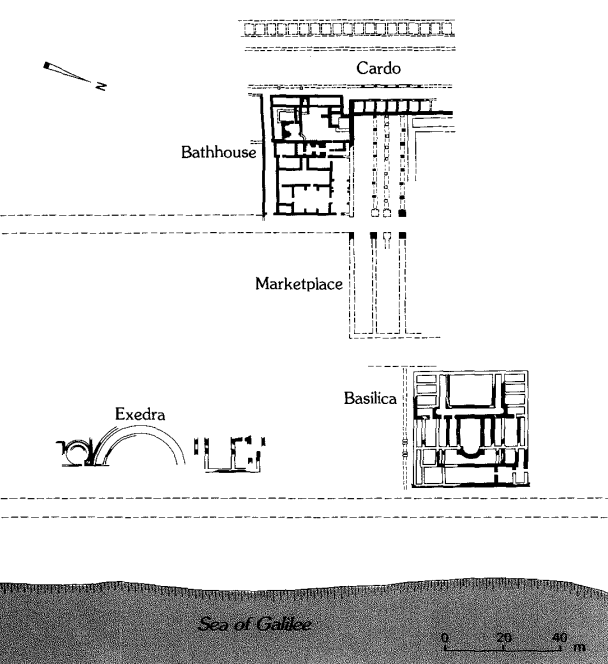 Plan of the main buildings in the city center. Plan of the main buildings in the city center
Stern et al (1993 v.4) - Tiberias Basilica in Google Earth
 Tiberias Basilica
click on image to explore this site on a new tab in Google Earth - Tiberias Basilica on govmap.gov.il
Tiberias Basilica
click on image to explore this site on a new tab in govmap.gov.il - Fig. 1 Plan of church on
the remains in the center of Tiberias from Hirschfeld and Meir (2004)
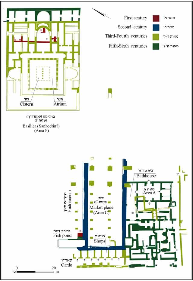 Figure 1
The remains in the center of Tiberias, plan.
Hirschfeld and Meir (2004)
- Fig. 1 Plan of church on
the remains in the center of Tiberias from Hirschfeld and Meir (2004)
Figure 1
The remains in the center of Tiberias, plan.
Hirschfeld and Meir (2004)
- Fig. 1 Plan of church on
the remains in the center of Tiberias from Hirschfeld and Meir (2004)
Figure 1
The remains in the center of Tiberias, plan.
Hirschfeld and Meir (2004)
- Fig. 1 Plan of church on
the remains in the center of Tiberias from Hirschfeld and Meir (2004)
Figure 1
The remains in the center of Tiberias, plan.
Hirschfeld and Meir (2004)
| Damage Type | Location | Image(s) | Comments |
|---|---|---|---|
| Collapsed walls and structure | Eastern wing
Figure 1 The remains in the center of Tiberias, plan. Hirschfeld and Meir (2004) |
|
|
| 2nd storey and roof collapse | Eastern wing
Figure 1 The remains in the center of Tiberias, plan. Hirschfeld and Meir (2004) |
|
| Damage Type | Location | Image(s) | Comments |
|---|---|---|---|
| Collapsed structure | Entire Building ?
Figure 1 The remains in the center of Tiberias, plan. Hirschfeld and Meir (2004) |
|
- Modified by JW from Fig. 1 of Hirschfeld and Meir (2004)
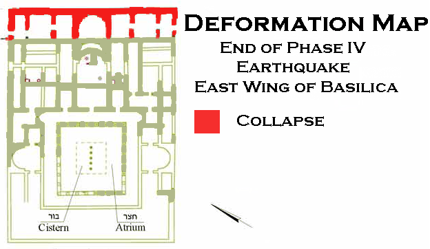 Deformation Map
Modified by JW from Fig. 1 of Hirschfeld and Meir (2004)
- Earthquake Archeological Effects chart
of Rodríguez-Pascua et al (2013: 221-224)
 Earthquake Archeological Effects (EAE)
Rodríguez-Pascua et al (2013: 221-224)
| Damage Type | Location | Image(s) | Comments | Intensity |
|---|---|---|---|---|
| Collapsed walls and structure | Eastern wing
Figure 1 The remains in the center of Tiberias, plan. Hirschfeld and Meir (2004) |
|
VIII+ | |
| 2nd storey and roof collapse | Eastern wing
Figure 1 The remains in the center of Tiberias, plan. Hirschfeld and Meir (2004) |
|
VIII+ |
- Earthquake Archeological Effects chart
of Rodríguez-Pascua et al (2013: 221-224)
Earthquake Archeological Effects (EAE)
Rodríguez-Pascua et al (2013: 221-224)
| Damage Type | Location | Image(s) | Comments | Intensity |
|---|---|---|---|---|
| Collapsed structure | Entire Building ?
Figure 1 The remains in the center of Tiberias, plan. Hirschfeld and Meir (2004) |
|
VIII+ |