Petra - Jabal Harun

Click on Image for higher resolution magnifiable image
- Reference: APAAME_20171001_RHB-0358
- Photographer: Robert Howard Bewley
- Credit: Aerial Photographic Archive for Archaeology in the Middle East
- Copyright: Creative Commons Attribution-Noncommercial-No Derivative Works
| Transliterated Name | Language | Name |
|---|---|---|
| Jabal Harun, Jabal Haroun | Arabic | جابال هارون |
| Jabal al-Nabī Hārūn | Arabic | جبل النبي هارون |
| Har Oharon | Hebrew | הר אהרן |
| Oros Aarōn | Greek | Ὄρος Ἀαρών |
| Mons Aaron | Latin |
- Fig. 1 - Location Map
from Kouki and Lavento (2013)
 Fig. 1
The Jabal Harun area
Kouki and Lavento (2013)
- Jabal Harun in Google Earth
 Jabal Harun in Google Earth
click on image to explore this site on a new tab in Google Earth - Fig. 1 - Aerial View after excavations
from Fiema (2012)
 Figure 1
The FJHP site following the end of excavations in 2007
(Photograph by Z. T. Fiema).
Fiema (2012)
- Fig. 2 - Plan of entire site
from Fiema (2013)
 Fig. 2
Plan of the FJHP site
(by K. Koistenan and V. Putkonen)
Fiema (2013) - Fig. 2 - Plan of the monastery
with walls and trench locations marked from Fiema (2008)
 Fig. 2 Chapter 5
The plan of the monastery following the 2005 field season.
Fiema (2008)
- Fig. 2 - Plan of
entire site from Fiema (2013)
Fig. 2
Plan of the FJHP site
(by K. Koistenan and V. Putkonen)
Fiema (2013) - Fig. 2 - Plan of
the monastery with walls and trench locations marked from Fiema (2008)
Fig. 2 Chapter 5
The plan of the monastery following the 2005 field season.
Fiema (2008)
- Fig. 8 - Plan of Church and Chapel
in Phase 2 from Mikkola et al (2008)
 Fig. 8 Chapter 6
The church and the chapel marking in Phase 2.
Mikkola et al (2008) - Fig. 10 - Isometric reconstruction
of the church and the chapel in Phase 2 from Mikkola et al (2008)
 Fig. 10
Isometric reconstruction of the church and the chapel in Phase 2.
Mikkola et al (2008) - Fig. 56 - Plan of Church and Chapel
in Phase 5 from Mikkola et al (2008)
 Fig. 56 Chapter 6
The church and the chapel marking in Phase 5.
Mikkola et al (2008) - Fig. 37 - Isometric reconstruction
of the church and the chapel in Phases 4-5 from Mikkola et al (2008)
 Fig. 37
Isometric reconstruction of the church and the chapel in Phases 4-5.
Mikkola et al (2008) - Fig. 59 - Plan of Church and Chapel
in Phase 7 from Mikkola et al (2008)
 Fig. 59 Chapter 6
The church and the chapel marking in Phase 7.
Mikkola et al (2008) - Fig. 67 - Isometric reconstruction
of the church and the chapel in Phase 7 from Mikkola et al (2008)
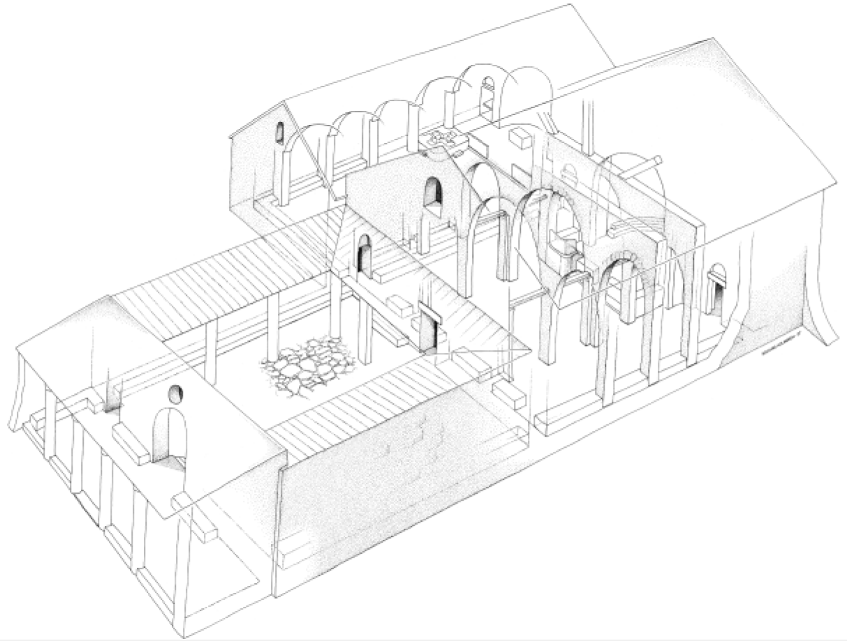 Fig. 67
Isometric reconstruction of the church and the chapel in Phase 7.
Mikkola et al (2008) - Fig. 81 - Plan of Church and Chapel
in Phase 9 from Mikkola et al (2008)
 Fig. 81 Chapter 6
The church and the chapel marking in Phase 9.
Mikkola et al (2008) - Fig. 88 - Reconstruction of the
appearance of the church and the chapel in Phase 9 from Mikkola et al (2008)
 Fig. 88
Tentative reconstruction of the appearance of the church and the chapel in Phase 9.
Mikkola et al (2008) - Fig. 107 - Plan of Church and Chapel
in Phase 11 from Mikkola et al (2008)
 Fig. 107 Chapter 6
The church and the chapel marking in Phase 11.
Mikkola et al (2008)
- Fig. 1 - Plan of
Church and Chapel with all walls and trench locations marked from Fiema (2008)
 Fig. 1 Chapter 5
The plan of the church and the chapel marking all walls and trench locations.
Fiema (2008) - Labeled Plan of
Church and Chapel - modified from Fiema (2008)
 Plan of the church and the chapel with parts of the structure labeled in red
modified by JW from Fig. 1 of Fiema (2008)
- Fig. 1 - Plan of
Church and Chapel with all walls and trench locations marked from Fiema (2008)
Fig. 1 Chapter 5
The plan of the church and the chapel marking all walls and trench locations.
Fiema (2008) - Labeled Plan of
Church and Chapel - modified from Fiema (2008)
Plan of the church and the chapel with parts of the structure labeled in red
modified by JW from Fig. 1 of Fiema (2008)
- Stone by stone plan of
church and chapel from Fiema and Frosen (2008)
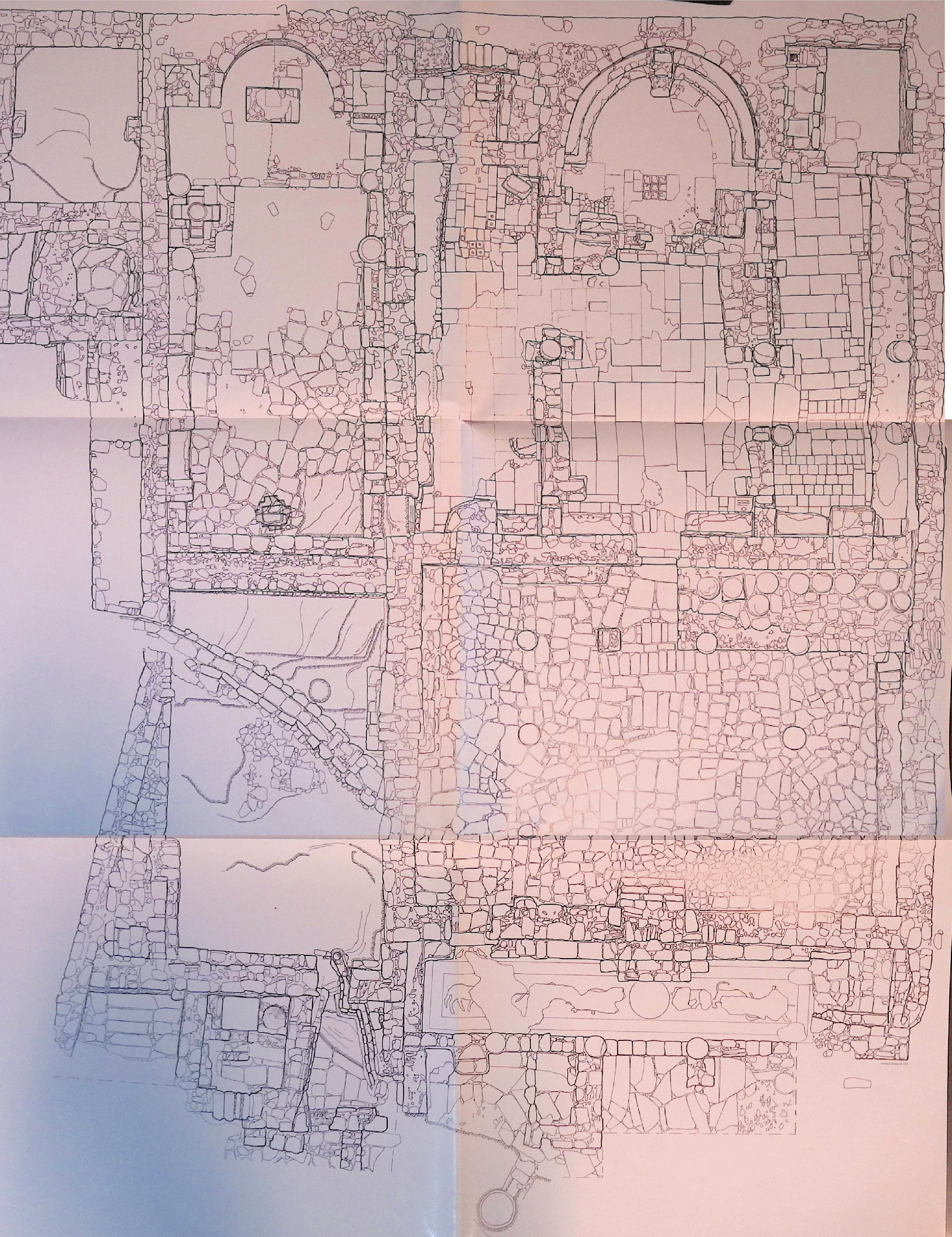 Stone by stone plan of church and chapel
click on image to open in a new tab
Fiema and Frosen (2008) - Fig. 17 - Stone by stone
plan of the eastern half of the church from Mikkola et. al. (2008)
 Fig. 17
The plan of the eastern half of the church
Mikkola et al (2008) - Fig. 33 - Stone by stone
plan of the northwestern part of the church from Mikkola et al (2008)
 Fig. 33
The plan of the northwestern part of the church.
Mikkola et al (2008) - Fig. 36 - Stone by stone
plan of the southwestern part of the church from Mikkola et al (2008)
 Fig. 36
The plan of the southwestern part of the church.
Mikkola et al (2008) - Fig. 50 - Stone by stone
plan of the narthex from Mikkola et al (2008)
 Fig. 50
Plan of the narthrex
Mikkola et al (2008) - Fig. 25 - Stone by stone
plan of the eastern part of the chapel from Mikkola et al (2008)
 Fig. 25
The plan of the eastern part of the chapel.
Mikkola et al (2008) - Fig. 29 - Stone by stone
plan of the western part of the chapel from Mikkola et al (2008)
 Fig. 29
The plan of the western part of the chapel.
Mikkola et al (2008)
- Stone by stone plan of
church and chapel from Fiema and Frosen (2008)
Stone by stone plan of church and chapel
click on image to open in a new tab
Fiema and Frosen (2008) - Fig. 33 - Stone by stone
plan of the northwestern part of the church from Mikkola et al (2008)
Fig. 33
The plan of the northwestern part of the church.
Mikkola et al (2008) - Fig. 36 - Stone by stone
plan of the southwestern part of the church from Mikkola et al (2008)
Fig. 36
The plan of the southwestern part of the church.
Mikkola et al (2008) - Fig. 50 - Stone by stone
plan of the narthex from Mikkola et al (2008)
Fig. 50
Plan of the narthrex
Mikkola et al (2008) - Fig. 25 - Stone by stone
plan of the eastern part of the chapel from Mikkola et al (2008)
Fig. 25
The plan of the eastern part of the chapel.
Mikkola et al (2008) - Fig. 29 - Stone by stone
plan of the western part of the chapel from Mikkola et al (2008)
Fig. 29
The plan of the western part of the chapel.
Mikkola et al (2008)
- Fig. 4 - Trench E, western baulk
from Mikkola et al (2008)
 Fig. 4
Trench E, western baulk
Mikkola et al (2008) - Fig. 13 - Trench F, eastern baulk
from Mikkola et al (2008)
 Fig. 13
Trench F, eastern baulk. Also showing the façade wall (W. AA, loci F.30 and 31) of the southern pastophorion, the pilaster F.32 of the southern colonnade, and the stone tumbles/soil layers inside the apse.
Mikkola et al (2008) - Fig. 19 - Trench E, southern baulk
from Mikkola et al (2008)
 Fig. 19
Trench E, southern baulk. Showing the profile of the synthronon, the layers of collapse inside the apse and the deposit of mosaic fragments in Phase 13.
Mikkola et al (2008) - Fig. 46 - Trench L, northern baulk
from Mikkola et al (2008)
 Fig. 46
Trench L, northern baulk. The stratigraphy of the atrium showing the pavement, location of columns, and subsequent stone collapses.
Mikkola et al (2008) - Fig. 58 - Trench B, northern baulk
from Mikkola et al (2008)
 Fig. 58
Trench B, northern baulk. Featuring the stratigraphy in the atrium showing the pavement, the water channel. locus B.12, the buttress, locus B.02 from Phase 9, and the stone tumbles.
Mikkola et al (2008) - Fig. 76 - Trench C, northern baulk
from Mikkola et al (2008)
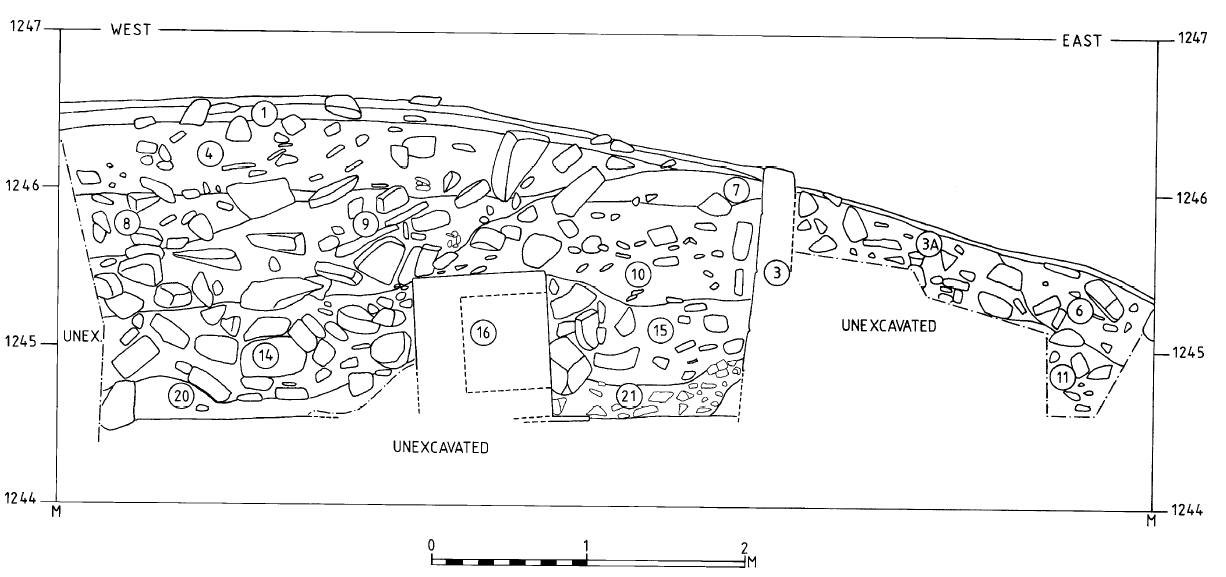 Fig. 76
Trench C, northern baulk. The stratigraphy inside the apse and the bema of the chapel, featuring the masonry altar pedestal, locus C.16, and the layers of stone tumble.
Mikkola et al (2008) - Fig. 94 - Trench F, western baulk
from Mikkola et al (2008)
 Fig. 94
Trench F, western baulk, featuring the bench, locus F.15, and the stone and soil deposits inside the southern aisle and the nave.
Mikkola et al (2008) - Fig. 114 - Trench F, northern baulk
from Mikkola et al (2008)
 Fig. 114
Trench F, northern baulk, featuring stone tumbles and soil deposits mentioned in the text.
Mikkola et al (2008) - Fig. 117 - Trench G, eastern baulk
from Mikkola et al (2008)
 Fig. 117
Trench G, eastern baulk, featuring the stone tumbles mentioned in the text.
Mikkola et al (2008)
- Fig. 3 - The Western Building
[thought to be the core of Nabatean sacral complex] with the bedrock fissure from Fiema (2012)
 Figure 3
The Western Building [thought to be the core of Nabatean sacral complex] with the bedrock fissure in front of it
(Photograph by Z. T. Fiema)
click on image to open in a new tab .
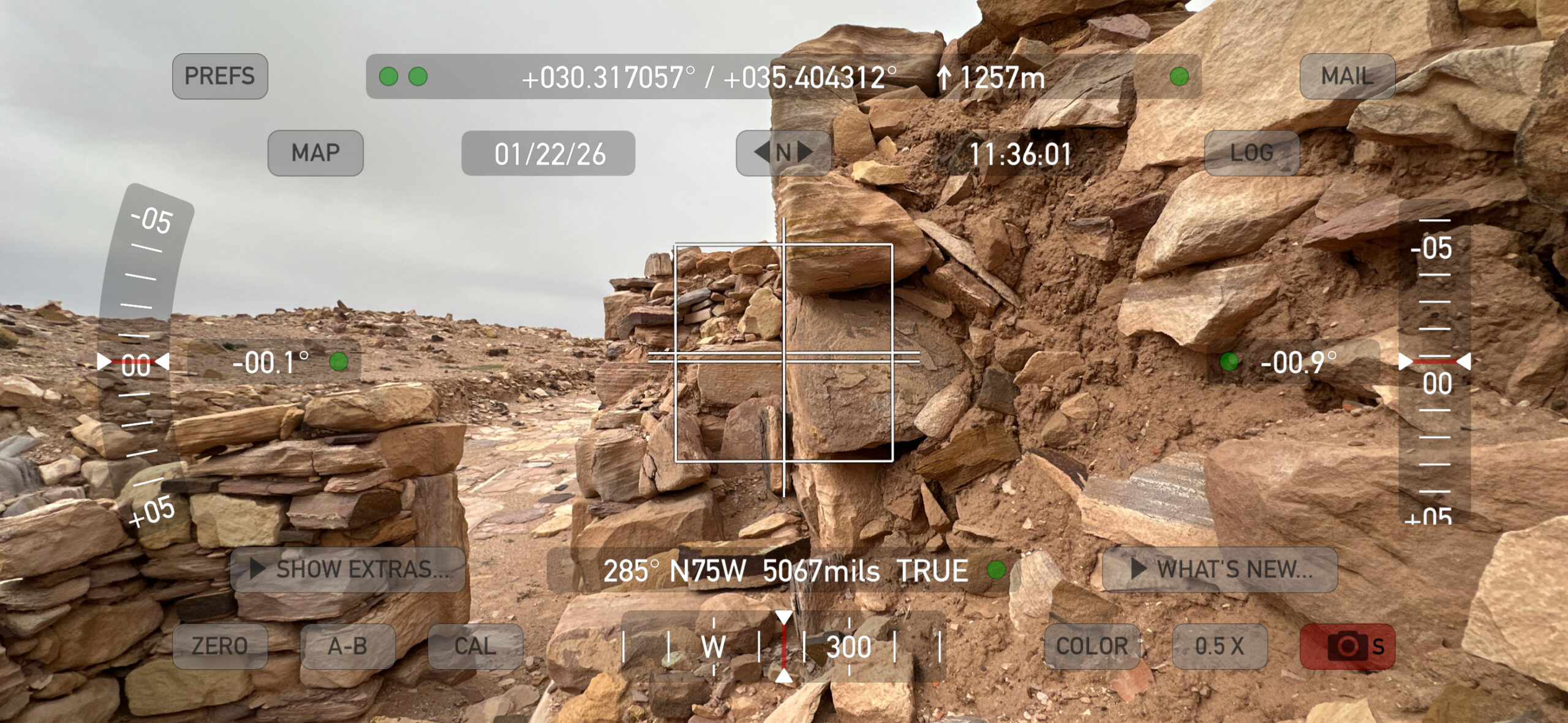
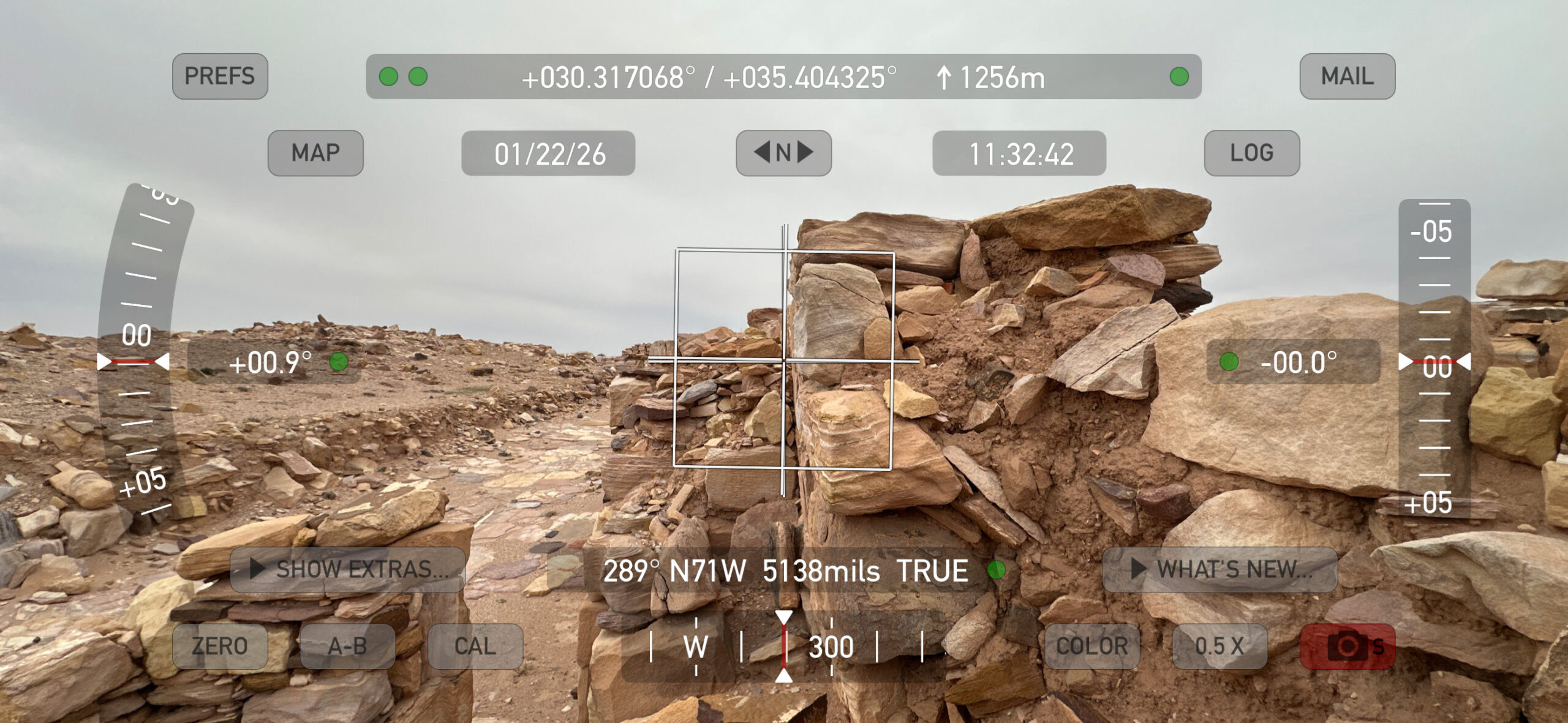
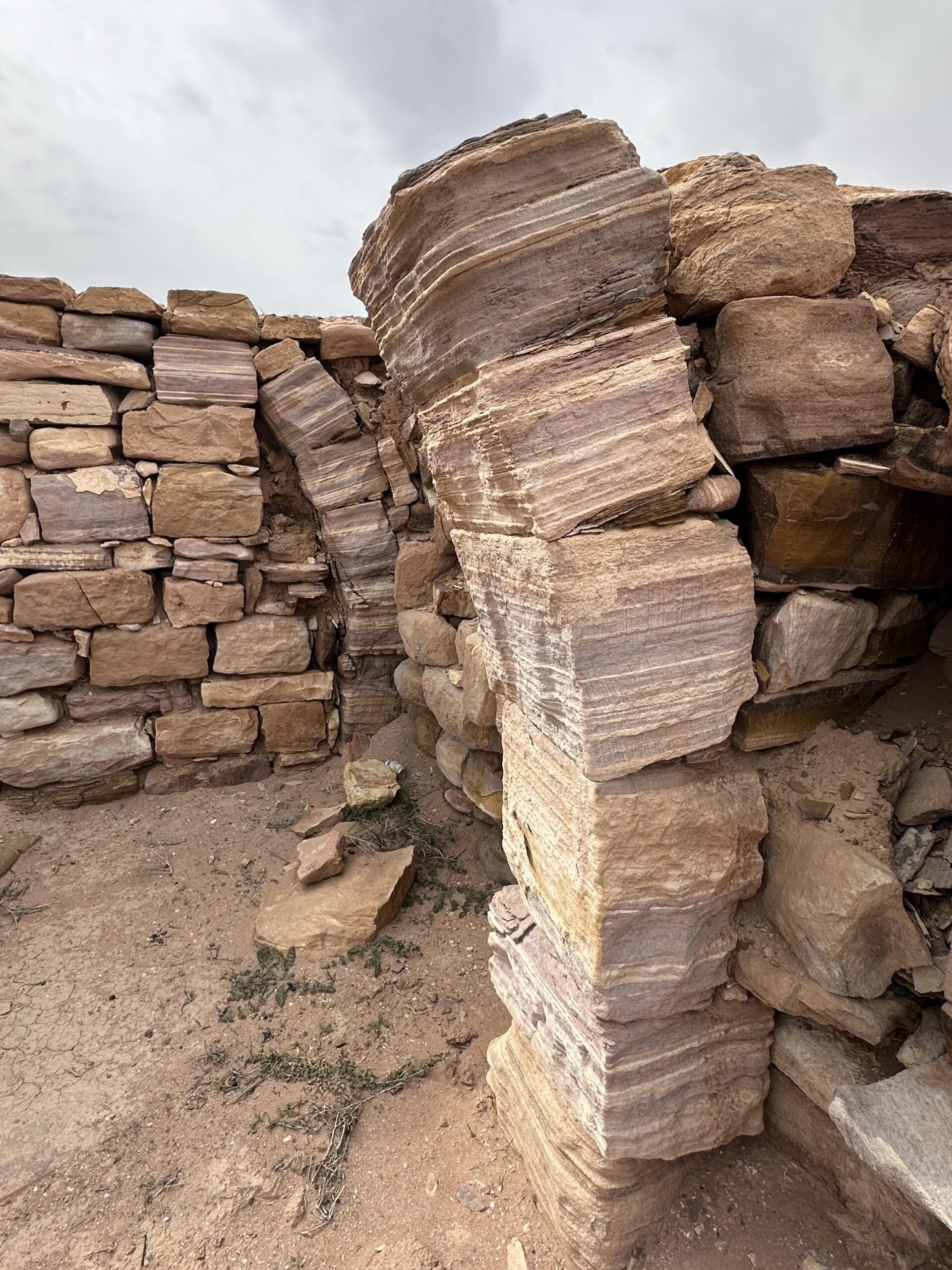
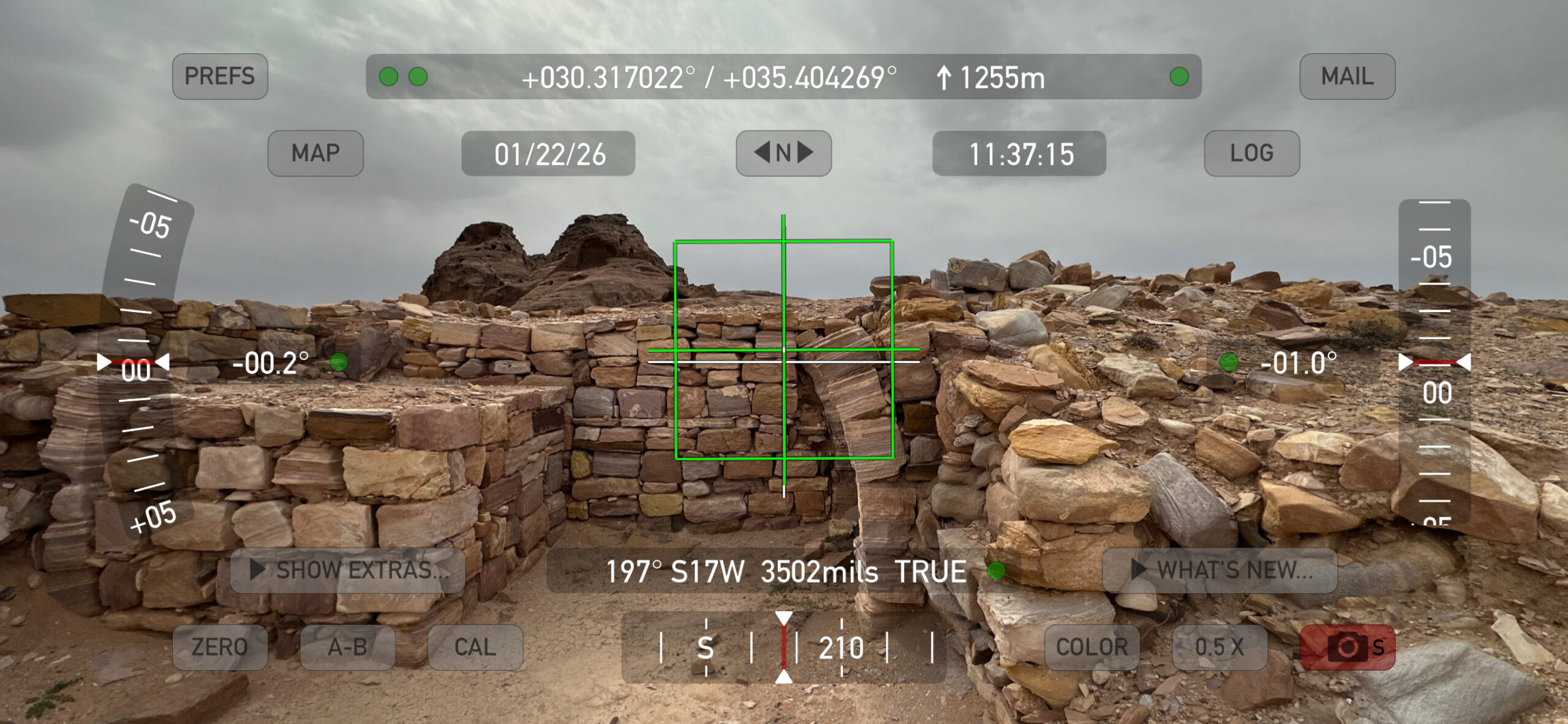
Fiema (2012) - Wall J tilted southward in
Phase 8 Earthquake - photo by JW
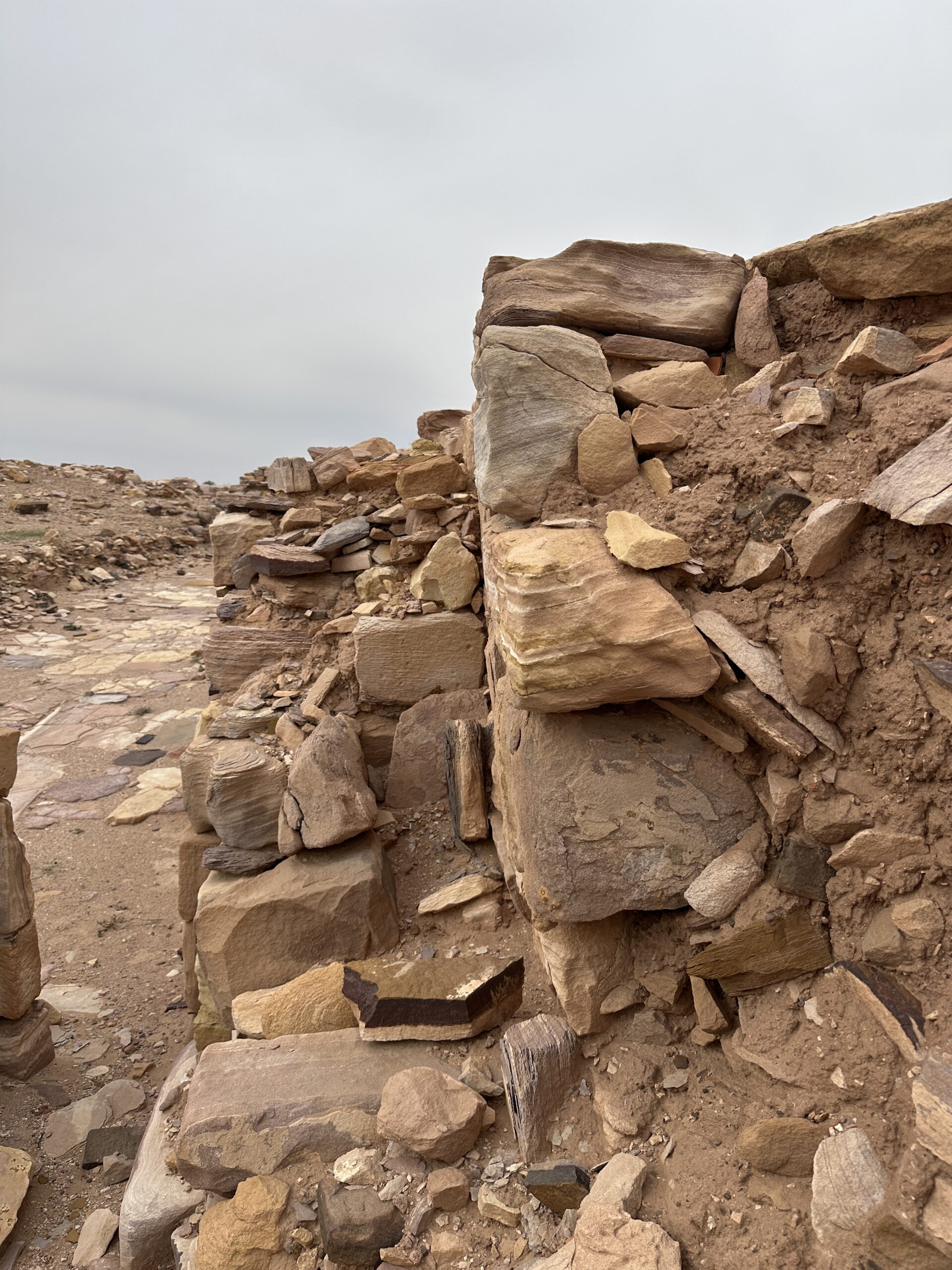 Wall J - tilted soutward in the Phase 8 earthquake with a buttress wall installed in the subsequent phase (9) - looking west
Click on image to open in a new tab
Photo by Jefferson Williams - 22 Jan. 2026 - Wall J tilted southward in
Phase 8 Earthquake - digital theodolite photo by JW
 Wall J - tilted soutward in the Phase 8 earthquake with a buttress wall installed in the subsequent phase (9) - looking west
Click on image to open in a new tab
Digital Theodolite Photo by Jefferson Williams - 22 Jan. 2026 - Wall J tilted southward in
Phase 8 Earthquake - tilt measures ~7 degrees - digital theodolite photo by JW
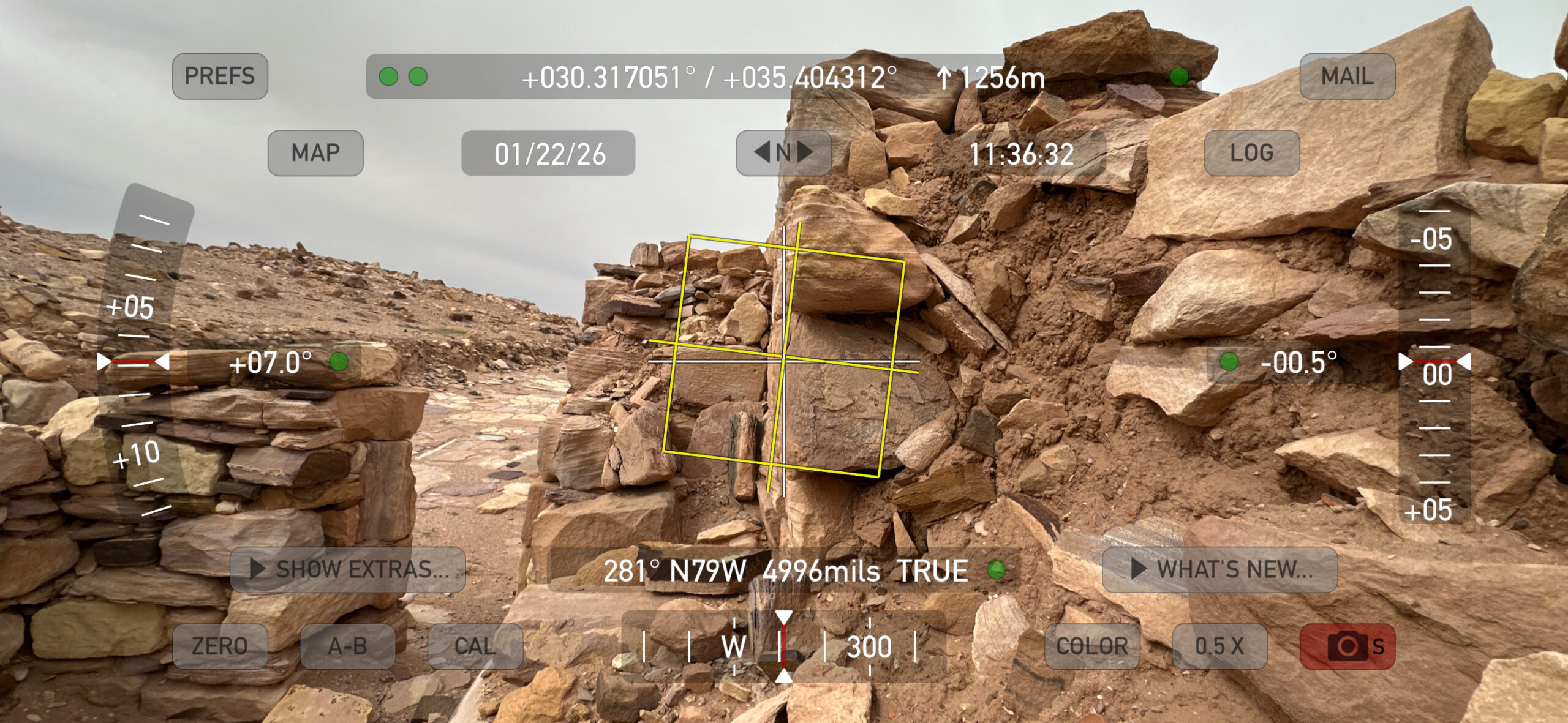 Wall J - tilted soutward in the Phase 8 earthquake with a buttress wall installed in the subsequent phase (9) - looking west - wall
tilt measures ~7 degrees
Wall J - tilted soutward in the Phase 8 earthquake with a buttress wall installed in the subsequent phase (9) - looking west - wall
tilt measures ~7 degrees
Click on image to open in a new tab
Digital Theodolite Photo by Jefferson Williams - 22 Jan. 2026 - Tilted And Collapsed Arches
photo by JW
 Tilted And Collapsed Arches
Click on image to open in a new tab
Photo by Jefferson Williams - 22 Jan. 2026 - Tilted And Collapsed Arches
digital theodolite photo by JW
 Tilted And Collapsed Arches
Click on image to open in a new tab
Digital Theodolite Photo by Jefferson Williams - 22 Jan. 2026 - Collapsed Arches photo by JW
 Collapsed Arches
Click on image to open in a new tab
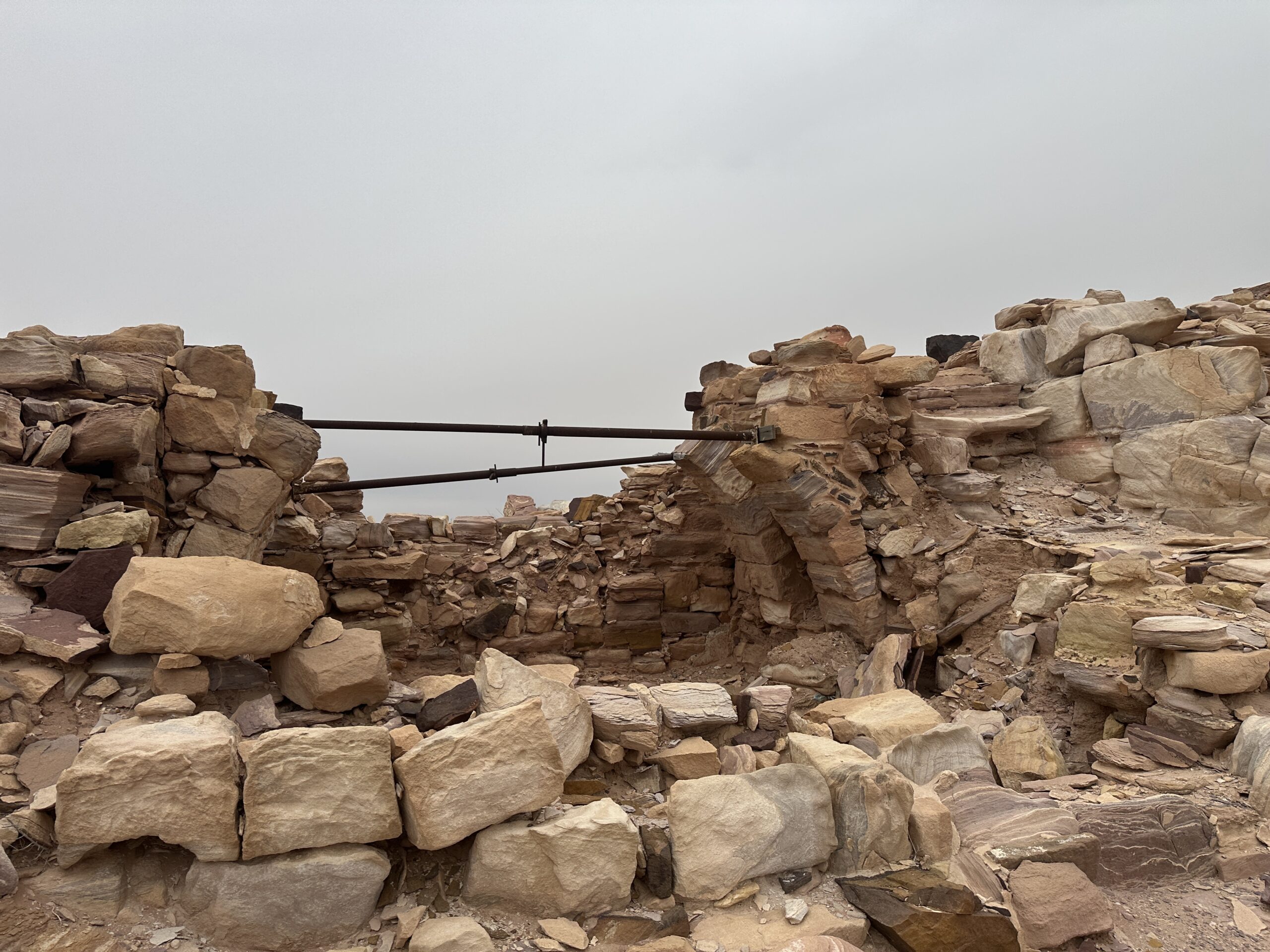
Photo by Jefferson Williams - 22 Jan. 2026 - Damaged And Filled In Arch
photo by JW
 Damaged And Filled In Arch
Click on image to open in a new tab
Photo by Jefferson Williams - 22 Jan. 2026 - Blocked Doorway photo by JW
 Blocked Doorway
Click on image to open in a new tab
Photo by Jefferson Williams - 22 Jan. 2026 - Cracked Flagstone Floor
photo by JW
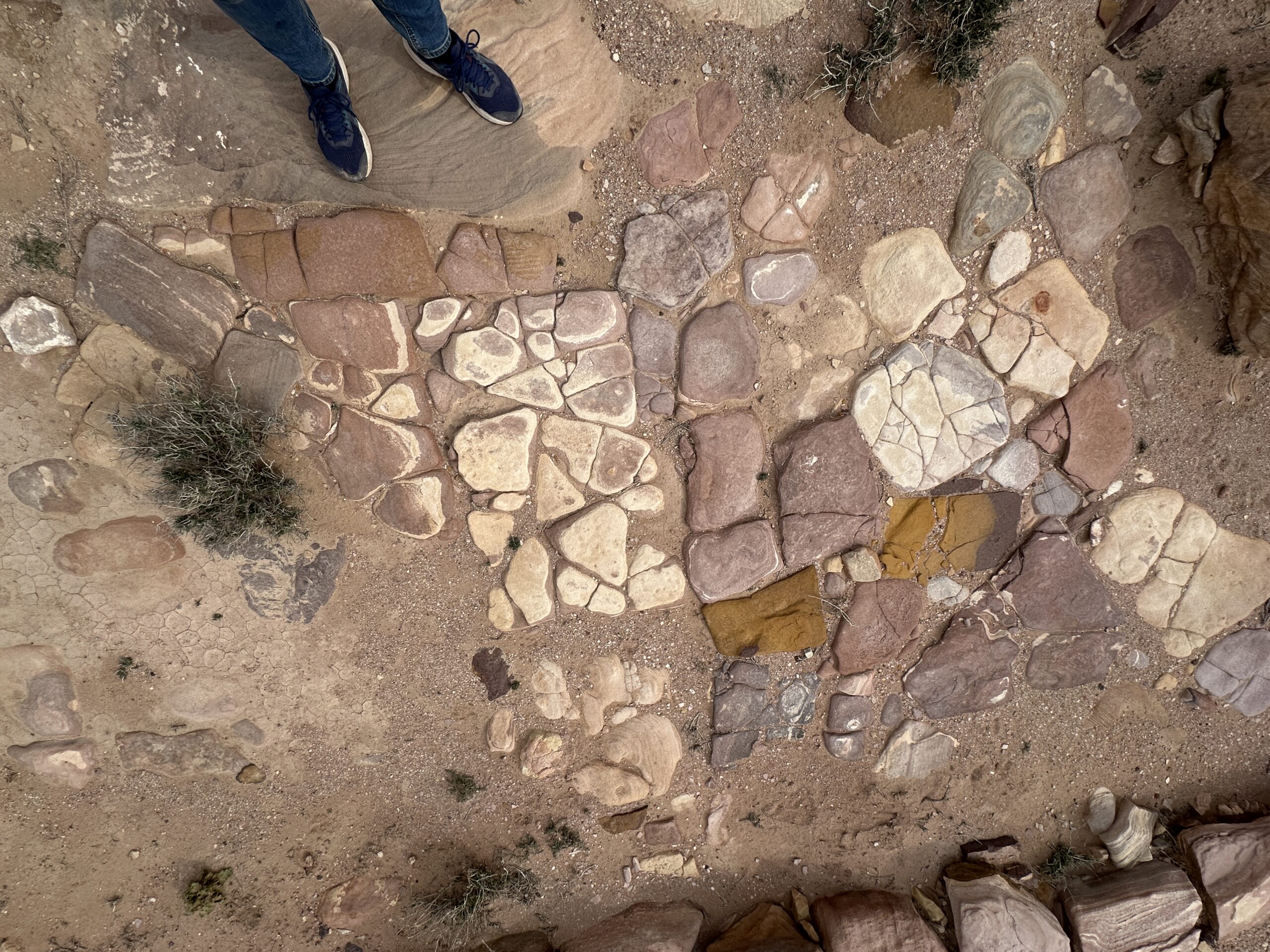 Cracked Flagstone Floor
Click on image to open in a new tab
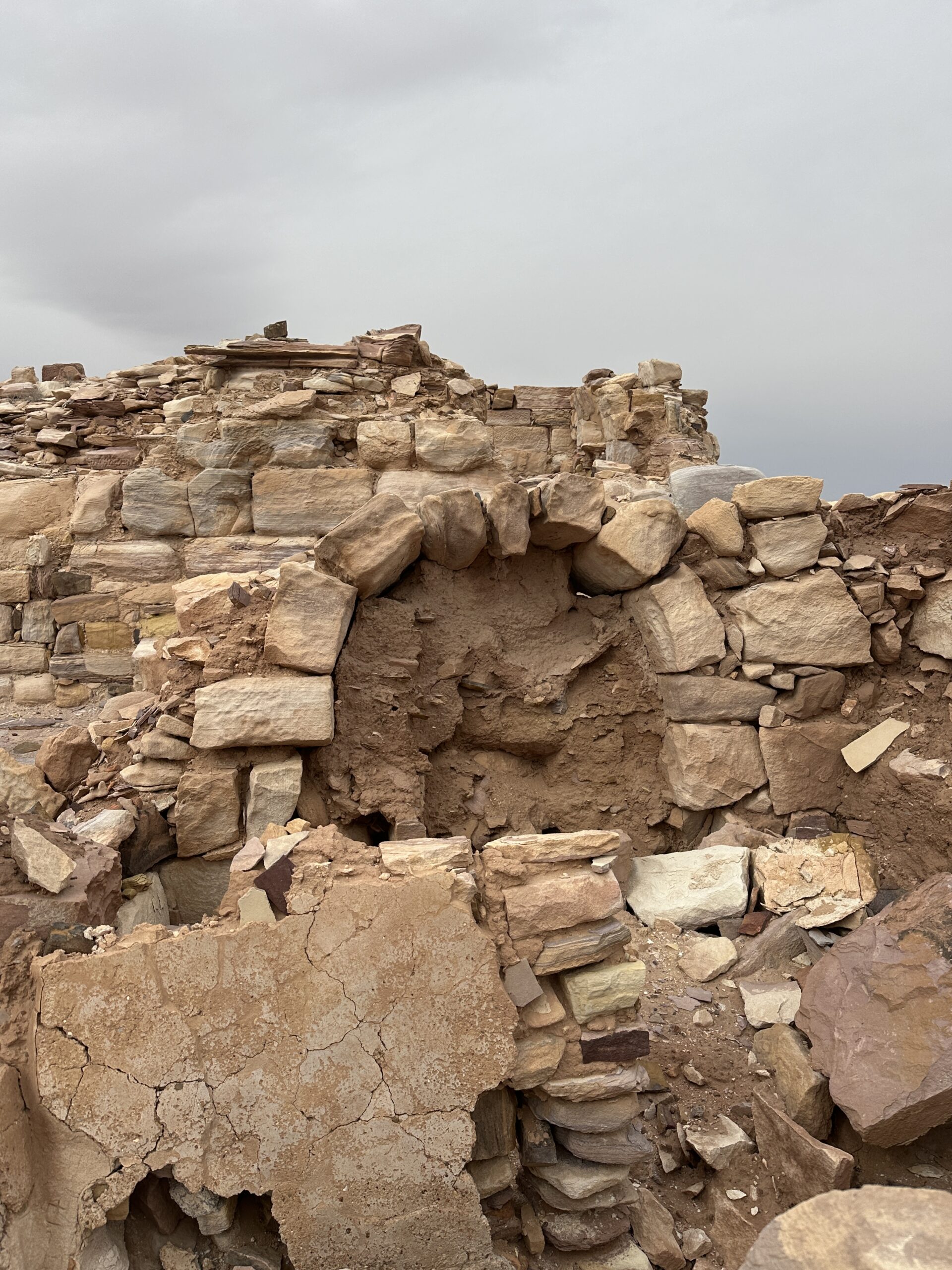
Photo by Jefferson Williams - 22 Jan. 2026 - Stone Cupboard photo by JW
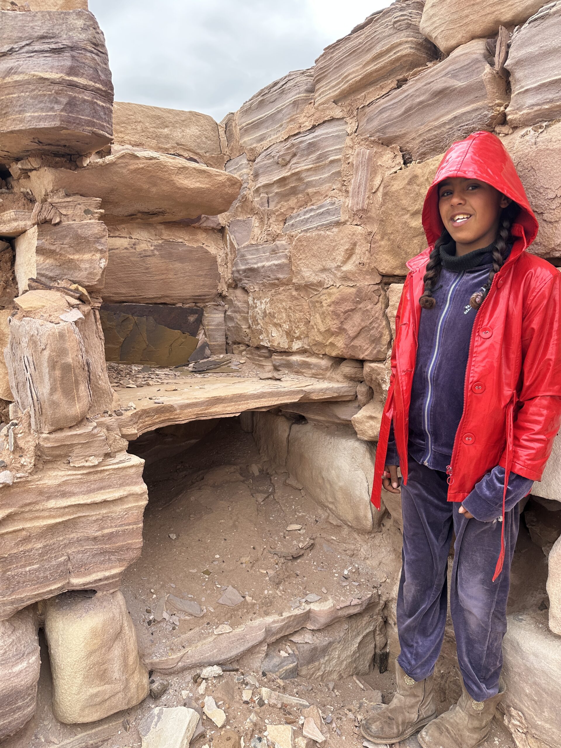 Stone Cupboard with field assistant Ghaza
Click on image to open in a new tab
Photo by Jefferson Williams - 22 Jan. 2026
- Fig. 3 - The Western Building
[thought to be the core of Nabatean sacral complex] with the bedrock fissure from Fiema (2012)
Figure 3
The Western Building [thought to be the core of Nabatean sacral complex] with the bedrock fissure in front of it
(Photograph by Z. T. Fiema)
click on image to open in a new tab .
Fiema (2012) - Wall J tilted southward in
Phase 8 Earthquake - photo by JW
Wall J - tilted soutward in the Phase 8 earthquake with a buttress wall installed in the subsequent phase (9) - looking west
Click on image to open in a new tab
Photo by Jefferson Williams - 22 Jan. 2026 - Wall J tilted southward in
Phase 8 Earthquake - digital theodolite photo by JW
Wall J - tilted soutward in the Phase 8 earthquake with a buttress wall installed in the subsequent phase (9) - looking west
Click on image to open in a new tab
Digital Theodolite Photo by Jefferson Williams - 22 Jan. 2026 - Wall J tilted southward in
Phase 8 Earthquake - tilt measures ~7 degrees - digital theodolite photo by JW
Wall J - tilted soutward in the Phase 8 earthquake with a buttress wall installed in the subsequent phase (9) - looking west - wall
tilt measures ~7 degrees
Click on image to open in a new tab
Digital Theodolite Photo by Jefferson Williams - 22 Jan. 2026 - Tilted And Collapsed Arches
photo by JW
Tilted And Collapsed Arches
Click on image to open in a new tab
Photo by Jefferson Williams - 22 Jan. 2026 - Tilted And Collapsed Arches
digital theodolite photo by JW
Tilted And Collapsed Arches
Click on image to open in a new tab
Digital Theodolite Photo by Jefferson Williams - 22 Jan. 2026 - Collapsed Arches photo by JW
Collapsed Arches
Click on image to open in a new tab
Photo by Jefferson Williams - 22 Jan. 2026 - Damaged And Filled In Arch
photo by JW
Damaged And Filled In Arch
Click on image to open in a new tab
Photo by Jefferson Williams - 22 Jan. 2026 - Blocked Doorway photo by JW
Blocked Doorway
Click on image to open in a new tab
Photo by Jefferson Williams - 22 Jan. 2026 - Cracked Flagstone Floor
photo by JW
Cracked Flagstone Floor
Click on image to open in a new tab
Photo by Jefferson Williams - 22 Jan. 2026 - Stone Cupboard photo by JW
Stone Cupboard with field assistant Ghaza
Click on image to open in a new tab
Photo by Jefferson Williams - 22 Jan. 2026
 Concordance between the phasing of the Church and Chapel of the site
Fiema and Frosen (2008 Appendix C)
- from Schmid (1995)
- Ez-Zantur Excavations utilized Nabatean fineware chronology of Schmid (2000) - which I don't currently have access to
- reference was made to Schmid's Nabatean fineware chronology in section(s) of the excavation reports dealing with pre-monastic phasing at Jabal Harun
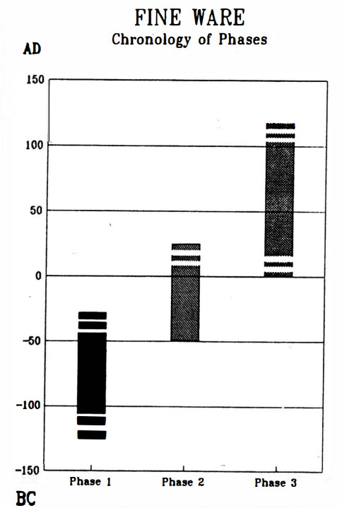
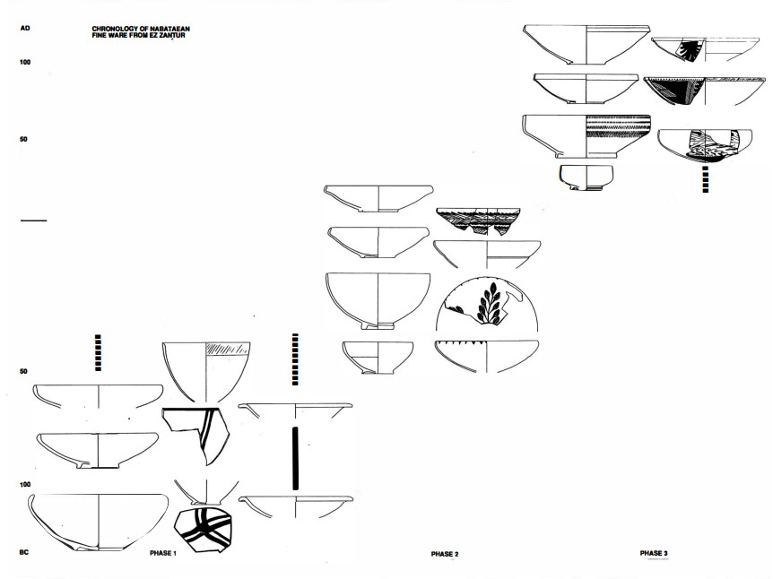
Left
Chronology of Nabatean finewares
Right
Typology and chronology of the Nabataean fine ware
Both from Schmid (1995)
- Fig. 2 - Cistern interior
from Mikkola et al (2008)
 Fig. 2
The interior of the cistern at the foot of the summit of Jabal Harun.
Mikkola et al (2008) - Fig. 3 - Re-used building element
from pre-monastic times in Wall Y from Mikkola et al (2008)
 Fig. 3
An architectural element in Wall Y
Mikkola et al (2008) - Fig. 4 - Trench E, western baulk
from Mikkola et al (2008)
Fig. 4
Trench E, western baulk
Mikkola et al (2008) - Fig. 5 - Grey tesserae found
in Trench J from Mikkola et al (2008)
 Fig. 5
Large quantities of grey tesserae found in Trench J.
Mikkola et al (2008) - Fig. 6 - Water channels
around the cistern from Mikkola et al (2008)
 Fig. 6
Four water channels in the area of the cistern. The settling tank is visible in the center.
Mikkola et al (2008) - Fig. 7 - Interior of the settling tank
from Mikkola et al (2008)
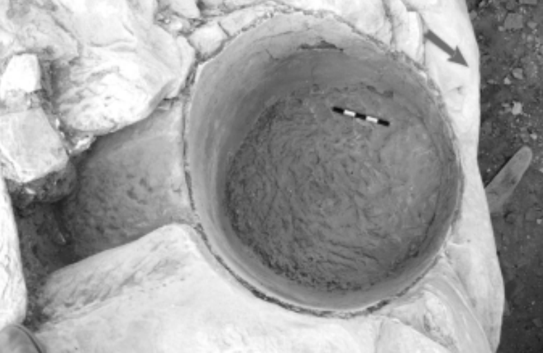 Fig. 7
Interior of the settling tank featuring the hydraulic mortar in the center.
Mikkola et al (2008)
- Fig. 1 - Plan of Church and Chapel
with all walls and trench locations marked from Fiema (2008)
Fig. 1 Chapter 5
The plan of the church and the chapel marking all walls and trench locations.
Fiema (2008) - Fig. 8 - Plan of Church and Chapel
in Phase 2 from Mikkola et al (2008)
Fig. 8 Chapter 6
The church and the chapel marking in Phase 2.
Mikkola et al (2008) - Fig. 10 - Isometric reconstruction
of the church and the chapel in Phase 2 from Mikkola et al (2008)
Fig. 10
Isometric reconstruction of the church and the chapel in Phase 2.
Mikkola et al (2008)
- Fig. 30 - Charcoal and molten glass
from the Phase 3 fire from Mikkola et al (2008)
 Fig. 30.
Locus V. 15 – the deposit of charcoal and molten glass.
Mikkola et al (2008) - Fig. 34 - Collapsed Column
found among Phase 13 stone tumble from Mikkola et al (2008)
 Fig. 34.
Locus T.14 — the collapsed column
Mikkola et al (2008) - Fig. 44 - Repaired marble floor
in the nave of the church - from Mikkola et al (2008)
 Fig. 44.
The appearance of the marble floor in the nave of the church.
Mikkola et al (2008)
- Fig. 1 - Plan of Church and Chapel
with all walls and trench locations marked from Fiema (2008)
Fig. 1 Chapter 5
The plan of the church and the chapel marking all walls and trench locations.
Fiema (2008) - Fig. 8 - Plan of Church and Chapel
in Phase 2 from Mikkola et al (2008)
Fig. 8 Chapter 6
The church and the chapel marking in Phase 2.
Mikkola et al (2008) - Fig. 10 - Isometric reconstruction
of the church and the chapel in Phase 2 from Mikkola et al (2008)
Fig. 10
Isometric reconstruction of the church and the chapel in Phase 2.
Mikkola et al (2008)
- Fig. 30 - Charcoal and molten glass
from the Phase 3 fire from Mikkola et al (2008)
Fig. 30.
Locus V. 15 – the desposit of charcoal and molten glass.
Mikkola et al (2008) - Fig. 34 - Collapsed Column
from Mikkola et al (2008)
Fig. 34.
Locus T.14 — the collapsed column
Mikkola et al (2008) - Fig. 44 - Repaired marble floor
in the nave of the church - from Mikkola et al (2008)
Fig. 44.
The appearance of the marble floor in the nave of the church.
Mikkola et al (2008)
- Fig. 1 - Plan of Church and Chapel
with all walls and trench locations marked from Fiema (2008)
Fig. 1 Chapter 5
The plan of the church and the chapel marking all walls and trench locations.
Fiema (2008) - Fig. 56 - Plan of Church and Chapel
in Phase 5 from Mikkola et al (2008)
Fig. 56 Chapter 6
The church and the chapel marking in Phase 5.
Mikkola et al (2008) - Fig. 37 - Isometric reconstruction
of the church and the chapel in Phases 4-5 from Mikkola et al (2008)
Fig. 37
Isometric reconstruction of the church and the chapel in Phases 4-5.
Mikkola et al (2008)
- Fig. 5 - Iconoclastic damage
from Fiema (2013)
 Fig. 5
Iconoclastic damage to the narthex mosaic
(by J. Vihonen)
Fiema (2013)
- Fig. 1 - Plan of Church and Chapel
with all walls and trench locations marked from Fiema (2008)
Fig. 1 Chapter 5
The plan of the church and the chapel marking all walls and trench locations.
Fiema (2008) - Fig. 56 - Plan of Church and Chapel
in Phase 5 from Mikkola et al (2008)
Fig. 56 Chapter 6
The church and the chapel marking in Phase 5.
Mikkola et al (2008) - Fig. 37 - Isometric reconstruction
of the church and the chapel in Phases 4-5 from Mikkola et al (2008)
Fig. 37
Isometric reconstruction of the church and the chapel in Phases 4-5.
Mikkola et al (2008)
- Fig. 5 - Iconoclastic damage
from Fiema (2013)
Fig. 5
Iconoclastic damage to the narthex mosaic
(by J. Vihonen)
Fiema (2013)
- Fig. 1 - Plan of Church and Chapel
with all walls and trench locations marked from Fiema (2008)
Fig. 1 Chapter 5
The plan of the church and the chapel marking all walls and trench locations.
Fiema (2008) - Fig. 59 - Plan of Church and Chapel
in Phase 7 from Mikkola et al (2008)
Fig. 59 Chapter 6
The church and the chapel marking in Phase 7.
Mikkola et al (2008) - Fig. 67 - Isometric reconstruction
of the church and the chapel in Phase 7 from Mikkola et al (2008)
Fig. 67
Isometric reconstruction of the church and the chapel in Phase 7.
Mikkola et al (2008)
- Fig. 80 - Tilted Wall
from Mikkola et al (2008)
 Fig. 80.
Wall J tilting southward, following the earthquake of Phase 8.
Mikkola et al (2008) - Fig. 5 - Iconoclastic damage
from Fiema (2013)
Fig. 5
Iconoclastic damage to the narthex mosaic
(by J. Vihonen)
Fiema (2013)
- Fig. 1 - Plan of Church and Chapel
with all walls and trench locations marked from Fiema (2008)
Fig. 1 Chapter 5
The plan of the church and the chapel marking all walls and trench locations.
Fiema (2008) - Fig. 59 - Plan of Church and Chapel
in Phase 7 from Mikkola et al (2008)
Fig. 59 Chapter 6
The church and the chapel marking in Phase 7.
Mikkola et al (2008) - Fig. 67 - Isometric reconstruction
of the church and the chapel in Phase 7 from Mikkola et al (2008)
Fig. 67
Isometric reconstruction of the church and the chapel in Phase 7.
Mikkola et al (2008)
- Fig. 80 - Tilted Wall
from Mikkola et al (2008)
Fig. 80.
Wall J tilting southward, following the earthquake of Phase 8.
Mikkola et al (2008) - Fig. 5 - Iconoclastic damage
from Fiema (2013)
Fig. 5
Iconoclastic damage to the narthex mosaic
(by J. Vihonen)
Fiema (2013) - Fig. 62 - southern “cross-column”
from Mikkola et al (2008)
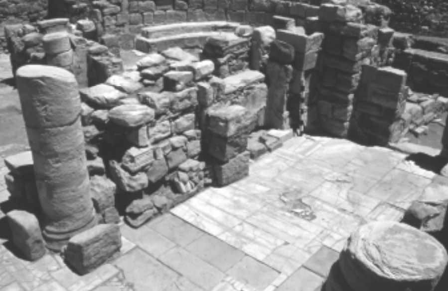 Fig. 62
The southern “cross-column” (on the left).
Mikkola et al (2008) - Fig. 63 - Pilasters
from Mikkola et al (2008)
 Fig. 63
The appearance of the pilasters set against the northern “cross-column.”
Mikkola et al (2008) - Fig. 64 - Three pilasters
from Mikkola et al (2008)
 Fig. 64.
The three pilasters (extreme left) of Phase 7 built against Wall H in the northern aisle.
Mikkola et al (2008) - Fig. 65 - The plastered element
from Mikkola et al (2008)
 Fig. 65
The plastered element, locus G.12 (in the center).
Mikkola et al (2008) - Fig. 66 - cross scratched
on the surface of the plastered element from Mikkola et al (2008)
 Fig. 66
A cross scratched on the surface of the plastered element, locus T.11. (in the center).
Mikkola et al (2008) - Fig. 103 - Buttress against
Wall J from Mikkola et al (2008)
 Fig. 103
The Phase 9 buttress, locus T.31, built against Wall J. (in the center).
Mikkola et al (2008) - Fig. 99 - Phase 9 Buttress
in the atrium from Mikkola et al (2008)
 Fig. 99
The Phase 9 buttress, loci B.02, B.16, B.18 and L.02, in the atrium (in the center).
Mikkola et al (2008) - Fig. 36 - Stone by stone plan
of SW part of church from Mikkola et al (2008)
Fig. 36
The plan of the southwestern part of the church.
Mikkola et al (2008) - Fig. 58 - Trench B section
from Mikkola et al (2008)
Fig. 58
Trench B, northern baulk. Featuring the stratigraphy in the atrium, including the pavement, the water channel, locus B.12, the buttress, locus B.02, from Phase 9, and the stone tumbles.
Mikkola et al (2008)
- Fig. 1 - Plan of Church and Chapel
with all walls and trench locations marked from Fiema (2008)
Fig. 1 Chapter 5
The plan of the church and the chapel marking all walls and trench locations.
Fiema (2008) - Fig. 81 - Plan of Church and Chapel
in Phase 9 from Mikkola et al (2008)
Fig. 81 Chapter 6
The church and the chapel marking in Phase 9.
Mikkola et al (2008) - Fig. 88 - Reconstruction of the
appearance of the church and the chapel in Phase 9 from Mikkola et al (2008)
Fig. 88
Tentative reconstruction of the appearance of the church and the chapel in Phase 9.
Mikkola et al (2008) - Fig. 107 - Plan of Church and Chapel
in Phase 11 from Mikkola et al (2008)
Fig. 107 Chapter 6
The church and the chapel marking in Phase 11.
Mikkola et al (2008)
- Fig. 85 - Phase 9 arch supports
in S Aisle of Church from Fiema (2013)
 Fig. 85
The Phase 9 arch supports (two columns and a pilaster) and the wide bench built against Wall J in the southern aisle.
(by J. Vihonen)
Fiema (2013) - Fig. 86 - Phase 9 arch supports
in S Aisle of Church from Fiema (2013)
 Fig. 86
The Phase 9 arch supports on each side of the southern aisle.
(by J. Vihonen)
Fiema (2013) - Fig. 87 - Phase 9 pilaster
from Fiema (2013)
 Fig. 87
The Phase 9 pilaster (left side), locus F.05d.
(by J. Vihonen)
Fiema (2013) - Fig. 76 - Trench C, northern baulk
from Mikkola et al (2008)
Fig. 76
Trench C, northern baulk. The stratigraphy inside the apse and the bema of the chapel, featuring the masonry altar pedestal, locus C.16, and the layers of stone tumble.
Mikkola et al (2008)
- Fig. 1 - Plan of Church and Chapel
with all walls and trench locations marked from Fiema (2008)
Fig. 1 Chapter 5
The plan of the church and the chapel marking all walls and trench locations.
Fiema (2008) - Fig. 107 - Plan of Church and Chapel
in Phase 11 from Mikkola et al (2008)
Fig. 107 Chapter 6
The church and the chapel marking in Phase 11.
Mikkola et al (2008)
- Fig. 114 - Section drawing
showing stone tumble from Mikkola et al (2008)
 Fig. 114.
Trench F, northern baulk, featuring stone tumbles and soil deposits mentioned in the text.
Mikkola et al (2008) - Fig. 115 - Collapsed arches
from Mikkola et al (2008)
 Fig. 115.
Collapsed arches in locus F.05.
Mikkola et al (2008) - Fig. 116 - Collapsed arch
from Mikkola et al (2008)
 Fig. 116
Collapsed arch in locus T.05.
Mikkola et al (2008) - Fig. 117 - Trench G, eastern baulk
from Mikkola et al (2008)
Fig. 117
Trench G, eastern baulk, featuring the stone tumbles mentioned in the text.
Mikkola et al (2008) - Fig. 118 - Collapsed arches
from Mikkola et al (2008)
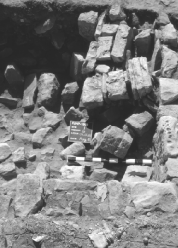 Fig. 118
Collapsed arches in locus G.04
Mikkola et al (2008) - Fig. 34 - Collapsed Column
found among Phase 13 stone tumble from Mikkola et al (2008)
Fig. 34.
Locus T.14 — the collapsed column
Mikkola et al (2008) - Fig. 30 - Charcoal and molten glass
from the Phase 3 fire from Mikkola et al (2008)
Fig. 30.
Locus V. 15 – the desposit of charcoal and molten glass.
Mikkola et al (2008)
- from Mikkola et al (2008)
- Fig. 1 - Plan of Church and Chapel
with all walls and trench locations marked from Fiema (2008)
Fig. 1 Chapter 5
The plan of the church and the chapel marking all walls and trench locations.
Fiema (2008) - Fig. 107 - Plan of Church and Chapel
in Phase 11 from Mikkola et al (2008)
Fig. 107 Chapter 6
The church and the chapel marking in Phase 11.
Mikkola et al (2008) - Fig. 29 - plan of the western
part of the chapel from Mikkola et al (2008)
Fig. 29
The plan of the western part of the chapel.
Mikkola et al (2008)
- Fig. 114 - Section drawing
showing stone tumble from Mikkola et al (2008)
Fig. 114.
Trench F, northern baulk, featuring stone tumbles and soil deposits mentioned in the text.
Mikkola et al (2008) - Fig. 115 - Collapsed arches
from Mikkola et al (2008)
Fig. 115.
Collapsed arches in locus F.05.
Mikkola et al (2008) - Fig. 116 - Collapsed arch
from Mikkola et al (2008)
Fig. 116
Collapsed arch in locus T.05.
Mikkola et al (2008) - Fig. 117 - Trench G, eastern baulk
from Mikkola et al (2008)
Fig. 117
Trench G, eastern baulk, featuring the stone tumbles mentioned in the text.
Mikkola et al (2008) - Fig. 118 - Collapsed arches
from Mikkola et al (2008)
Fig. 118
Collapsed arches in locus G.04
Mikkola et al (2008) - Fig. 30 - Charcoal and molten glass
from the Phase 3 fire from Mikkola et al (2008)
Fig. 30.
Locus V. 15 – the desposit of charcoal and molten glass.
Mikkola et al (2008)
| Effect | Location | Image(s) | Description |
|---|---|---|---|
| Shattered floor | second story floor O.41 in Room 25 |
|
|
| Collapsed walls | core of Western Building |
|
|
| Collapsed arches | southern cistern (Room 36) |
Fig. 2 The interior of the cistern at the foot of the summit of Jabal Harun. JW: Unsure if this is the southern cistern Mikkola et al (2008) |
|
| Effect | Location | Image(s) | Description |
|---|---|---|---|
| Roof collapse | Church Roof
Fig. 1 Chapter 5 The plan of the church and the chapel marking all walls and trench locations. Fiema (2008)
Fig. 8 Chapter 6The church and the chapel marking in Phase 2. Mikkola et al (2008)
Fig. 56 Chapter 6The church and the chapel marking in Phase 5. Mikkola et al (2008) |
|
|
| Wall collapse | Upper parts of walls in the Church
Fig. 1 Chapter 5 The plan of the church and the chapel marking all walls and trench locations. Fiema (2008)
Fig. 8 Chapter 6The church and the chapel marking in Phase 2. Mikkola et al (2008)
Fig. 56 Chapter 6The church and the chapel marking in Phase 5. Mikkola et al (2008) |
|
|
| Arch collapse | Arches of the church
Fig. 1 Chapter 5 The plan of the church and the chapel marking all walls and trench locations. Fiema (2008)
Fig. 8 Chapter 6The church and the chapel marking in Phase 2. Mikkola et al (2008)
Fig. 56 Chapter 6The church and the chapel marking in Phase 5. Mikkola et al (2008) |
|
|
| Fallen Columns | columns of the church
Fig. 1 Chapter 5 The plan of the church and the chapel marking all walls and trench locations. Fiema (2008)
Fig. 8 Chapter 6The church and the chapel marking in Phase 2. Mikkola et al (2008)
Fig. 56 Chapter 6The church and the chapel marking in Phase 5. Mikkola et al (2008) |
|
|
| Shattered Floors | Marble floors of the church - particularly locus F.24 in the nave
Fig. 1 Chapter 5 The plan of the church and the chapel marking all walls and trench locations. Fiema (2008)
Fig. 8 Chapter 6The church and the chapel marking in Phase 2. Mikkola et al (2008)
Fig. 56 Chapter 6The church and the chapel marking in Phase 5. Mikkola et al (2008) |
Fig. 44. The appearance of the marble floor in the nave of the church. JW: This is after this floor was haphazardly repaired in the following phase [i.e. after phase 3]. Mikkola et al (2008) |
|
| Broken Furnishings | Church
Fig. 1 Chapter 5 The plan of the church and the chapel marking all walls and trench locations. Fiema (2008)
Fig. 8 Chapter 6The church and the chapel marking in Phase 2. Mikkola et al (2008)
Fig. 56 Chapter 6The church and the chapel marking in Phase 5. Mikkola et al (2008) |
|
|
| Fire | Possibly the entire site
Fig. 2 Chapter 5 The plan of the monastery following the 2005 field season. Fiema (2008) |
Fig. 30. Locus V. 15 – the deposit of charcoal and molten glass. Mikkola et al (2008) |
|
| Debris | from various parts of the site but deposited in Trench R
Fig. 2 Chapter 5 The plan of the monastery following the 2005 field season. JW: Trench R is in the lower left corner of drawing Fiema (2008) |
|
| Effect | Location | Image(s) | Description |
|---|---|---|---|
| Roof collapse | Chapel Roof
Fig. 1 Chapter 5 The plan of the church and the chapel marking all walls and trench locations. Fiema (2008)
Fig. 8 Chapter 6The church and the chapel marking in Phase 2. Mikkola et al (2008)
Fig. 56 Chapter 6The church and the chapel marking in Phase 5. Mikkola et al (2008) |
|
|
| Wall collapse | Upper parts of walls in the Chapel
Fig. 1 Chapter 5 The plan of the church and the chapel marking all walls and trench locations. Fiema (2008)
Fig. 8 Chapter 6The church and the chapel marking in Phase 2. Mikkola et al (2008)
Fig. 56 Chapter 6The church and the chapel marking in Phase 5. Mikkola et al (2008) |
|
|
| Wall collapse | Western Wall of the Chapel
Fig. 1 Chapter 5 The plan of the church and the chapel marking all walls and trench locations. Fiema (2008)
Fig. 8 Chapter 6The church and the chapel marking in Phase 2. Mikkola et al (2008)
Fig. 56 Chapter 6The church and the chapel marking in Phase 5. Mikkola et al (2008) |
|
|
| Wall collapse | Wall H of the Chapel
Fig. 1 Chapter 5 The plan of the church and the chapel marking all walls and trench locations. Fiema (2008)
Fig. 8 Chapter 6The church and the chapel marking in Phase 2. Mikkola et al (2008)
Fig. 56 Chapter 6The church and the chapel marking in Phase 5. Mikkola et al (2008) |
|
|
| Fallen Columns | the Chapel
Fig. 1 Chapter 5 The plan of the church and the chapel marking all walls and trench locations. Fiema (2008)
Fig. 8 Chapter 6The church and the chapel marking in Phase 2. Mikkola et al (2008)
Fig. 56 Chapter 6The church and the chapel marking in Phase 5. Mikkola et al (2008) |
|
|
| Shattered Floors | Marble floors of the chapel
Fig. 1 Chapter 5 The plan of the church and the chapel marking all walls and trench locations. Fiema (2008)
Fig. 8 Chapter 6The church and the chapel marking in Phase 2. Mikkola et al (2008)
Fig. 56 Chapter 6The church and the chapel marking in Phase 5. Mikkola et al (2008) |
|
|
| Broken Furnishings | The Chapel
Fig. 1 Chapter 5 The plan of the church and the chapel marking all walls and trench locations. Fiema (2008)
Fig. 8 Chapter 6The church and the chapel marking in Phase 2. Mikkola et al (2008)
Fig. 56 Chapter 6The church and the chapel marking in Phase 5. Mikkola et al (2008) |
|
|
| Broken Pilasters | The chapel
Fig. 1 Chapter 5 The plan of the church and the chapel marking all walls and trench locations. Fiema (2008)
Fig. 8 Chapter 6The church and the chapel marking in Phase 2. Mikkola et al (2008)
Fig. 56 Chapter 6The church and the chapel marking in Phase 5. Mikkola et al (2008) |
|
|
| Fire | Possibly the entire site
Fig. 2 Chapter 5 The plan of the monastery following the 2005 field season. Fiema (2008) |
Fig. 30. Locus V. 15 – the deposit of charcoal and molten glass. Mikkola et al (2008) |
|
| Debris | from various parts of the site but deposited in Trench R
Fig. 2 Chapter 5 The plan of the monastery following the 2005 field season. JW: Trench R is in the lower left corner of drawing Fiema (2008) |
|
- only better attested damage is listed
| Effect | Location | Image(s) | Description |
|---|---|---|---|
| Arch Collapse | Church
Fig. 1 Chapter 5 The plan of the church and the chapel marking all walls and trench locations. Fiema (2008)
Fig. 56 Chapter 6The church and the chapel marking in Phase 5. Mikkola et al (2008)
Fig. 59 Chapter 6The church and the chapel marking in Phase 7. Mikkola et al (2008) |
|
|
| Possible Wall damage | Church
Fig. 1 Chapter 5 The plan of the church and the chapel marking all walls and trench locations. Fiema (2008)
Fig. 56 Chapter 6The church and the chapel marking in Phase 5. Mikkola et al (2008)
Fig. 59 Chapter 6The church and the chapel marking in Phase 7. Mikkola et al (2008) |
|
|
| Possible Floor damage | Church
Fig. 1 Chapter 5 The plan of the church and the chapel marking all walls and trench locations. Fiema (2008)
Fig. 56 Chapter 6The church and the chapel marking in Phase 5. Mikkola et al (2008)
Fig. 59 Chapter 6The church and the chapel marking in Phase 7. Mikkola et al (2008) |
|
| Effect | Location | Image(s) | Description |
|---|---|---|---|
| Vault collapse | Semidome over apse in the Church
Fig. 1 Chapter 5 The plan of the church and the chapel marking all walls and trench locations. Fiema (2008)
Fig. 59 Chapter 6The church and the chapel marking in Phase 7. Mikkola et al (2008)
Fig. 81 Chapter 6The church and the chapel marking in Phase 9. Mikkola et al (2008) |
|
|
| Tilted Wall | Wall J in the Church
Fig. 1 Chapter 5 The plan of the church and the chapel marking all walls and trench locations. Fiema (2008)
Fig. 59 Chapter 6The church and the chapel marking in Phase 7. Mikkola et al (2008)
Fig. 81 Chapter 6The church and the chapel marking in Phase 9. Mikkola et al (2008) |
Fig. 80. Wall J tilting southward, following the earthquake of Phase 8. Mikkola et al (2008)
Fig. 103The Phase 9 buttress, locus T.31, built against Wall J. (in the center). Mikkola et al (2008) |
|
| Damaged Wall ? | Wall GG in the Chapel (part of locus Y.13)
Fig. 1 Chapter 5 The plan of the church and the chapel marking all walls and trench locations. Fiema (2008)
Fig. 59 Chapter 6The church and the chapel marking in Phase 7. Mikkola et al (2008)
Fig. 81 Chapter 6The church and the chapel marking in Phase 9. Mikkola et al (2008) |
|
|
| Damaged Walls ? | southeastern corner of the atrium,
against Wall I
Fig. 1 Chapter 5 The plan of the church and the chapel marking all walls and trench locations. Fiema (2008)
Fig. 59 Chapter 6The church and the chapel marking in Phase 7. Mikkola et al (2008)
Fig. 81 Chapter 6The church and the chapel marking in Phase 9. Mikkola et al (2008) |
Fig. 99 The Phase 9 buttress, loci B.02, B.16, B.18 and L.02, in the atrium (in the center). Mikkola et al (2008)
Fig. 36The plan of the southwestern part of the church. Mikkola et al (2008)
Fig. 58Trench B, northern baulk. Featuring the stratigraphy in the atrium, including the pavement, the water channel, locus B.12, the buttress, locus B.02, from Phase 9, and the stone tumbles. Mikkola et al (2008) |
|
| Limited Upper Wall collapse and roof collapse ? | southern pastophorion in the Church
Fig. 1 Chapter 5 The plan of the church and the chapel marking all walls and trench locations. Fiema (2008)
Fig. 59 Chapter 6The church and the chapel marking in Phase 7. Mikkola et al (2008)
Fig. 81 Chapter 6The church and the chapel marking in Phase 9. Mikkola et al (2008) |
|
|
| Displaced, Folded, or Collapsed Walls | section of Wall H in the
atrium
(loci V.06, X.13)
Fig. 1 Chapter 5 The plan of the church and the chapel marking all walls and trench locations. Fiema (2008)
Fig. 59 Chapter 6The church and the chapel marking in Phase 7. Mikkola et al (2008)
Fig. 81 Chapter 6The church and the chapel marking in Phase 9. Mikkola et al (2008) |
|
|
| Folded or Displaced Walls ? (suggested by possible pilaster damage | atrium in the Church
Fig. 1 Chapter 5 The plan of the church and the chapel marking all walls and trench locations. Fiema (2008)
Fig. 59 Chapter 6The church and the chapel marking in Phase 7. Mikkola et al (2008)
Fig. 81 Chapter 6The church and the chapel marking in Phase 9. Mikkola et al (2008) |
|
|
| Arch collapse | N-S arch spanning the Southern Aisle in the Church
Fig. 1 Chapter 5 The plan of the church and the chapel marking all walls and trench locations. Fiema (2008)
Fig. 59 Chapter 6The church and the chapel marking in Phase 7. Mikkola et al (2008)
Fig. 81 Chapter 6The church and the chapel marking in Phase 9. Mikkola et al (2008) |
|
|
| Arch collapse | N-S arches spanning the nave in the Church
Fig. 1 Chapter 5 The plan of the church and the chapel marking all walls and trench locations. Fiema (2008)
Fig. 59 Chapter 6The church and the chapel marking in Phase 7. Mikkola et al (2008)
Fig. 81 Chapter 6The church and the chapel marking in Phase 9. Mikkola et al (2008) |
|
|
| Arch collapse | northern pastophorion in the Church
Fig. 1 Chapter 5 The plan of the church and the chapel marking all walls and trench locations. Fiema (2008)
Fig. 59 Chapter 6The church and the chapel marking in Phase 7. Mikkola et al (2008)
Fig. 81 Chapter 6The church and the chapel marking in Phase 9. Mikkola et al (2008) |
|
|
| Arch collapse ? | southern pastophorion in the Church
Fig. 1 Chapter 5 The plan of the church and the chapel marking all walls and trench locations. Fiema (2008)
Fig. 59 Chapter 6The church and the chapel marking in Phase 7. Mikkola et al (2008)
Fig. 81 Chapter 6The church and the chapel marking in Phase 9. Mikkola et al (2008) |
|
|
| collonade and Column Collapse | atrium in the Church
Fig. 1 Chapter 5 The plan of the church and the chapel marking all walls and trench locations. Fiema (2008)
Fig. 59 Chapter 6The church and the chapel marking in Phase 7. Mikkola et al (2008)
Fig. 81 Chapter 6The church and the chapel marking in Phase 9. Mikkola et al (2008) |
|
|
| Shattered Floor | Floor of the apse in the Church
Fig. 1 Chapter 5 The plan of the church and the chapel marking all walls and trench locations. Fiema (2008)
Fig. 59 Chapter 6The church and the chapel marking in Phase 7. Mikkola et al (2008)
Fig. 81 Chapter 6The church and the chapel marking in Phase 9. Mikkola et al (2008) |
|
|
| Shattered Floors ? | atrium in the Church
Fig. 1 Chapter 5 The plan of the church and the chapel marking all walls and trench locations. Fiema (2008)
Fig. 59 Chapter 6The church and the chapel marking in Phase 7. Mikkola et al (2008)
Fig. 81 Chapter 6The church and the chapel marking in Phase 9. Mikkola et al (2008) |
|
|
| Shattered Floor ? | narthex in the Church
Fig. 1 Chapter 5 The plan of the church and the chapel marking all walls and trench locations. Fiema (2008)
Fig. 59 Chapter 6The church and the chapel marking in Phase 7. Mikkola et al (2008)
Fig. 81 Chapter 6The church and the chapel marking in Phase 9. Mikkola et al (2008) |
|
|
| Unspecified damage (probably from falling objects) | bema in the Church
Fig. 1 Chapter 5 The plan of the church and the chapel marking all walls and trench locations. Fiema (2008)
Fig. 59 Chapter 6The church and the chapel marking in Phase 7. Mikkola et al (2008)
Fig. 81 Chapter 6The church and the chapel marking in Phase 9. Mikkola et al (2008) |
|
| Effect | Location | Image(s) | Description |
|---|---|---|---|
| Cratered Floor | western part of the nave and the northern
aisle in the Church
Fig. 1 Chapter 5 The plan of the church and the chapel marking all walls and trench locations. Fiema (2008)
Fig. 81 Chapter 6The church and the chapel marking in Phase 9. Mikkola et al (2008)
Fig. 107 Chapter 6The church and the chapel marking in Phase 11. Mikkola et al (2008) |
|
|
| Collapsed Arch | N-S arch running between pilasters T.04 and G.06
in the Church
Fig. 1 Chapter 5 The plan of the church and the chapel marking all walls and trench locations. Fiema (2008)
Fig. 81 Chapter 6The church and the chapel marking in Phase 9. Mikkola et al (2008)
Fig. 107 Chapter 6The church and the chapel marking in Phase 11. Mikkola et al (2008) |
|
|
| Collapsed Arch | westernmost arch in the
northern aisle and the one that spanned the easternmost part of the nave
Fig. 1 Chapter 5 The plan of the church and the chapel marking all walls and trench locations. Fiema (2008)
Fig. 81 Chapter 6The church and the chapel marking in Phase 9. Mikkola et al (2008)
Fig. 107 Chapter 6The church and the chapel marking in Phase 11. Mikkola et al (2008) |
|
|
| Collapse | lowest parts of locus H.02 in the area of the Narthex
Fig. 1 Chapter 5 The plan of the church and the chapel marking all walls and trench locations. Fiema (2008)
Fig. 81 Chapter 6The church and the chapel marking in Phase 9. Mikkola et al (2008)
Fig. 107 Chapter 6The church and the chapel marking in Phase 11. Mikkola et al (2008) |
|
|
| Roof Collapse ? | floor of the Chapel
Fig. 1 Chapter 5 The plan of the church and the chapel marking all walls and trench locations. Fiema (2008)
Fig. 81 Chapter 6The church and the chapel marking in Phase 9. Mikkola et al (2008)
Fig. 107 Chapter 6The church and the chapel marking in Phase 11. Mikkola et al (2008) |
|
| Effect | Location | Image(s) | Description |
|---|---|---|---|
| Roof collapse | Church
Fig. 1 Chapter 5 The plan of the church and the chapel marking all walls and trench locations. Fiema (2008)
Fig. 107 Chapter 6The church and the chapel marking in Phase 11. Mikkola et al (2008) |
|
|
| Roof collapse | nave - loci T.18, U.21, U.23 [partly], T.21 (upper part of locus
relatively close to floor level (elevation 45.19) in the
western part of nave), part of locus U.21,
elevation 45.22 in the central part of the
nave ca.
0.10 m above the marble floor
Fig. 1 Chapter 5 The plan of the church and the chapel marking all walls and trench locations. Fiema (2008)
Fig. 107 Chapter 6The church and the chapel marking in Phase 11. Mikkola et al (2008) |
Fig. 29 The plan of the western part of the chapel. Mikkola et al (2008) |
|
| Roof collapse | Southern Aisle - eastern and western parts and locus F.12 (elevation 45.33 m)
Fig. 1 Chapter 5 The plan of the church and the chapel marking all walls and trench locations. Fiema (2008)
Fig. 107 Chapter 6The church and the chapel marking in Phase 11. Mikkola et al (2008) |
|
|
| Roof collapse | Northern Aisle - eastern parts
Fig. 1 Chapter 5 The plan of the church and the chapel marking all walls and trench locations. Fiema (2008)
Fig. 107 Chapter 6The church and the chapel marking in Phase 11. Mikkola et al (2008) |
|
|
| Collapsed Walls | southern aisle - loci F.14, F.12 in the east and locus T.13 in the west
Fig. 1 Chapter 5 The plan of the church and the chapel marking all walls and trench locations. Fiema (2008)
Fig. 107 Chapter 6The church and the chapel marking in Phase 11. Mikkola et al (2008) |
|
|
| Collapsed Walls | Wall T inside the Apse -
loci E.16, F.02, F.10, M.14, and U.11
Fig. 1 Chapter 5 The plan of the church and the chapel marking all walls and trench locations. Fiema (2008)
Fig. 107 Chapter 6The church and the chapel marking in Phase 11. Mikkola et al (2008) |
|
|
| Arch collapse | Church
Fig. 1 Chapter 5 The plan of the church and the chapel marking all walls and trench locations. Fiema (2008)
Fig. 107 Chapter 6The church and the chapel marking in Phase 11. Mikkola et al (2008) |
|
|
| Arch collapse | eastern part of the nave
one running N-S between the pilasters
loci F.07 and F.05d, and one apparently running E-W between the same
pilaster (F.05d)
to pilaster F.06
Fig. 1 Chapter 5 The plan of the church and the chapel marking all walls and trench locations. Fiema (2008)
Fig. 107 Chapter 6The church and the chapel marking in Phase 11. Mikkola et al (2008) |
Fig. 114. Trench F, northern baulk, featuring stone tumbles and soil deposits mentioned in the text. Mikkola et al (2008)
Fig. 115.Collapsed arches in locus F.05. Mikkola et al (2008) |
|
| Arch collapse | eastern part of the nave -
fallen arch originally sprang between the southern column and the
pilaster
(locus U.26) abutting the northern column
Fig. 1 Chapter 5 The plan of the church and the chapel marking all walls and trench locations. Fiema (2008)
Fig. 107 Chapter 6The church and the chapel marking in Phase 11. Mikkola et al (2008) |
Fig. 117 Trench G, eastern baulk, featuring the stone tumbles mentioned in the text. Mikkola et al (2008) |
|
| Arch collapse | Southern Aisle - western part
Fig. 1 Chapter 5 The plan of the church and the chapel marking all walls and trench locations. Fiema (2008)
Fig. 107 Chapter 6The church and the chapel marking in Phase 11. Mikkola et al (2008) |
Fig. 116 Collapsed arch in locus T.05. Mikkola et al (2008) |
|
| Arch collapse | Northern Aisle - first one between the column (locus U.25) and
pilaster (locus U.17)
and second one between the pilasters (loci
U.18 and U.39) in the eastern part of the nave
Fig. 1 Chapter 5 The plan of the church and the chapel marking all walls and trench locations. Fiema (2008)
Fig. 107 Chapter 6The church and the chapel marking in Phase 11. Mikkola et al (2008) |
Fig. 118 Collapsed arches in locus G.04 Mikkola et al (2008)
Fig. 117Trench G, eastern baulk, featuring the stone tumbles mentioned in the text. Mikkola et al (2008) |
|
| Arch collapse | southern pastophorion -
loci M.13, M.15
Fig. 1 Chapter 5 The plan of the church and the chapel marking all walls and trench locations. Fiema (2008)
Fig. 107 Chapter 6The church and the chapel marking in Phase 11. Mikkola et al (2008) |
|
|
| Fallen Columns | central part of the nave included some
drums fallen from the northern column (locus U.25)
Fig. 1 Chapter 5 The plan of the church and the chapel marking all walls and trench locations. Fiema (2008)
Fig. 107 Chapter 6The church and the chapel marking in Phase 11. Mikkola et al (2008) |
|
|
| Fallen Columns | northern part of the Atrium -
part of locus X.05)
Fig. 1 Chapter 5 The plan of the church and the chapel marking all walls and trench locations. Fiema (2008)
Fig. 107 Chapter 6The church and the chapel marking in Phase 11. Mikkola et al (2008) |
|
|
| Fallen Columns | locus H.02 in the area of the
Narthex
Fig. 1 Chapter 5 The plan of the church and the chapel marking all walls and trench locations. Fiema (2008)
Fig. 107 Chapter 6The church and the chapel marking in Phase 11. Mikkola et al (2008) |
Fig. 30. Locus V. 15 – the desposit of charcoal and molten glass. Mikkola et al (2008) |
|
| Fallen Columns ? | northeastern corner of the
Atrium
Fig. 1 Chapter 5 The plan of the church and the chapel marking all walls and trench locations. Fiema (2008)
Fig. 107 Chapter 6The church and the chapel marking in Phase 11. Mikkola et al (2008) |
|
|
| Broken Doorjambs | west of the northern doorway of the
Narthex
Fig. 1 Chapter 5 The plan of the church and the chapel marking all walls and trench locations. Fiema (2008)
Fig. 107 Chapter 6The church and the chapel marking in Phase 11. Mikkola et al (2008) |
Fig. 30. Locus V. 15 – the desposit of charcoal and molten glass. Mikkola et al (2008) |
|
| Effect | Location | Image(s) | Description |
|---|---|---|---|
| Roof collapse | Church and CHapel
Fig. 1 Chapter 5 The plan of the church and the chapel marking all walls and trench locations. Fiema (2008)
Fig. 107 Chapter 6The church and the chapel marking in Phase 11. Mikkola et al (2008) |
|
|
| Vault collapse | inside the Apse
Fig. 1 Chapter 5 The plan of the church and the chapel marking all walls and trench locations. Fiema (2008)
Fig. 107 Chapter 6The church and the chapel marking in Phase 11. Mikkola et al (2008) |
|
|
| Collapsed Walls | Wall S and Apse wall
Fig. 1 Chapter 5 The plan of the church and the chapel marking all walls and trench locations. Fiema (2008)
Fig. 107 Chapter 6The church and the chapel marking in Phase 11. Mikkola et al (2008) |
|
|
| Arch collapse | The four central and western arches of the chapel - collapsed arches resting on the soil of loci Y.09 and I.10
Fig. 1 Chapter 5 The plan of the church and the chapel marking all walls and trench locations. Fiema (2008)
Fig. 107 Chapter 6The church and the chapel marking in Phase 11. Mikkola et al (2008) |
|
|
| Stone tumble | Chapel - (loci I.02, I.08, I.10, I.15, I.16, Y.05
[lower part], Y.08, Y.24) especially in the western and central
parts of the chapel
Fig. 1 Chapter 5 The plan of the church and the chapel marking all walls and trench locations. Fiema (2008)
Fig. 107 Chapter 6The church and the chapel marking in Phase 11. Mikkola et al (2008) |
|
- Modified by JW from Mikkola et al (2008)
 Deformation Map
modified by JW from Fig. 1 of Mikkola et al (2008)
- Modified by JW from Mikkola et al (2008)
 Deformation Map
modified by JW from Fig. 1 of Mikkola et al (2008)
- Modified by JW from Mikkola et al (2008)
 Deformation Map
modified by JW from Fig. 1 of Mikkola et al (2008)
- Earthquake Archeological Effects chart
of Rodríguez-Pascua et al (2013: 221-224)
 Earthquake Archeological Effects (EAE)
Rodríguez-Pascua et al (2013: 221-224)
| Effect | Location | Image(s) | Description | Intensity |
|---|---|---|---|---|
| Fractures, fold, and popups on pavements | second story floor O.41 in Room 25 |
|
VI + (probably higher since a different type of damage is indicated) | |
| Collapsed walls | core of Western Building |
|
VIII + | |
| Collapsed arches | southern cistern (Room 36) |
|
VI + |
- Earthquake Archeological Effects chart
of Rodríguez-Pascua et al (2013: 221-224)
Earthquake Archeological Effects (EAE)
Rodríguez-Pascua et al (2013: 221-224)
| Effect | Location | Image(s) | Description | Intensity |
|---|---|---|---|---|
| Wall collapse | Upper parts of walls in the Church
Fig. 1 Chapter 5 The plan of the church and the chapel marking all walls and trench locations. Fiema (2008)
Fig. 8 Chapter 6The church and the chapel marking in Phase 2. Mikkola et al (2008)
Fig. 56 Chapter 6The church and the chapel marking in Phase 5. Mikkola et al (2008) |
|
VIII+ | |
| Arch collapse | Arches of the church
Fig. 1 Chapter 5 The plan of the church and the chapel marking all walls and trench locations. Fiema (2008)
Fig. 8 Chapter 6The church and the chapel marking in Phase 2. Mikkola et al (2008)
Fig. 56 Chapter 6The church and the chapel marking in Phase 5. Mikkola et al (2008) |
|
VI+ | |
| Fallen Columns | columns of the church
Fig. 1 Chapter 5 The plan of the church and the chapel marking all walls and trench locations. Fiema (2008)
Fig. 8 Chapter 6The church and the chapel marking in Phase 2. Mikkola et al (2008)
Fig. 56 Chapter 6The church and the chapel marking in Phase 5. Mikkola et al (2008) |
|
V+ |
- Earthquake Archeological Effects chart
of Rodríguez-Pascua et al (2013: 221-224)
Earthquake Archeological Effects (EAE)
Rodríguez-Pascua et al (2013: 221-224)
| Effect | Location | Image(s) | Description | Intensity |
|---|---|---|---|---|
| Wall collapse | Upper parts of walls in the Chapel
Fig. 1 Chapter 5 The plan of the church and the chapel marking all walls and trench locations. Fiema (2008)
Fig. 8 Chapter 6The church and the chapel marking in Phase 2. Mikkola et al (2008)
Fig. 56 Chapter 6The church and the chapel marking in Phase 5. Mikkola et al (2008) |
|
VIII+ | |
| Wall collapse | Western Wall of the Chapel
Fig. 1 Chapter 5 The plan of the church and the chapel marking all walls and trench locations. Fiema (2008)
Fig. 8 Chapter 6The church and the chapel marking in Phase 2. Mikkola et al (2008)
Fig. 56 Chapter 6The church and the chapel marking in Phase 5. Mikkola et al (2008) |
|
VIII+ | |
| Wall collapse | Wall H of the Chapel
Fig. 1 Chapter 5 The plan of the church and the chapel marking all walls and trench locations. Fiema (2008)
Fig. 8 Chapter 6The church and the chapel marking in Phase 2. Mikkola et al (2008)
Fig. 56 Chapter 6The church and the chapel marking in Phase 5. Mikkola et al (2008) |
|
VIII+ | |
| Rotated and displaced masonry blocks in walls and drums in columns | the Chapel
Fig. 1 Chapter 5 The plan of the church and the chapel marking all walls and trench locations. Fiema (2008)
Fig. 8 Chapter 6The church and the chapel marking in Phase 2. Mikkola et al (2008)
Fig. 56 Chapter 6The church and the chapel marking in Phase 5. Mikkola et al (2008) |
|
VIII+ | |
| Displaced or Folded walls leading to broken Pilasters | The chapel
Fig. 1 Chapter 5 The plan of the church and the chapel marking all walls and trench locations. Fiema (2008)
Fig. 8 Chapter 6The church and the chapel marking in Phase 2. Mikkola et al (2008)
Fig. 56 Chapter 6The church and the chapel marking in Phase 5. Mikkola et al (2008) |
|
VII+ |
- Earthquake Archeological Effects chart
of Rodríguez-Pascua et al (2013: 221-224)
Earthquake Archeological Effects (EAE)
Rodríguez-Pascua et al (2013: 221-224)
| Effect | Location | Image(s) | Description | Intensity |
|---|---|---|---|---|
| Arch Collapse | Church
Fig. 1 Chapter 5 The plan of the church and the chapel marking all walls and trench locations. Fiema (2008)
Fig. 56 Chapter 6The church and the chapel marking in Phase 5. Mikkola et al (2008)
Fig. 59 Chapter 6The church and the chapel marking in Phase 7. Mikkola et al (2008) |
|
VI + |
- Earthquake Archeological Effects chart
of Rodríguez-Pascua et al (2013: 221-224)
Earthquake Archeological Effects (EAE)
Rodríguez-Pascua et al (2013: 221-224)
| Effect | Location | Image(s) | Description | Intensity |
|---|---|---|---|---|
| Vault collapse | Semidome over apse in the Church
Fig. 1 Chapter 5 The plan of the church and the chapel marking all walls and trench locations. Fiema (2008)
Fig. 59 Chapter 6The church and the chapel marking in Phase 7. Mikkola et al (2008)
Fig. 81 Chapter 6The church and the chapel marking in Phase 9. Mikkola et al (2008) |
|
VIII + | |
| Tilted Wall | Wall J in the Church
Fig. 1 Chapter 5 The plan of the church and the chapel marking all walls and trench locations. Fiema (2008)
Fig. 59 Chapter 6The church and the chapel marking in Phase 7. Mikkola et al (2008)
Fig. 81 Chapter 6The church and the chapel marking in Phase 9. Mikkola et al (2008) |
Fig. 80. Wall J tilting southward, following the earthquake of Phase 8. Mikkola et al (2008)
Fig. 103The Phase 9 buttress, locus T.31, built against Wall J. (in the center). Mikkola et al (2008) |
|
VI + |
| Damaged Wall ? | Wall GG in the Chapel (part of locus Y.13)
Fig. 1 Chapter 5 The plan of the church and the chapel marking all walls and trench locations. Fiema (2008)
Fig. 59 Chapter 6The church and the chapel marking in Phase 7. Mikkola et al (2008)
Fig. 81 Chapter 6The church and the chapel marking in Phase 9. Mikkola et al (2008) |
|
VI + | |
| Damaged Walls ? | southeastern corner of the atrium,
against Wall I
Fig. 1 Chapter 5 The plan of the church and the chapel marking all walls and trench locations. Fiema (2008)
Fig. 59 Chapter 6The church and the chapel marking in Phase 7. Mikkola et al (2008)
Fig. 81 Chapter 6The church and the chapel marking in Phase 9. Mikkola et al (2008) |
Fig. 99 The Phase 9 buttress, loci B.02, B.16, B.18 and L.02, in the atrium (in the center). Mikkola et al (2008)
Fig. 36The plan of the southwestern part of the church. Mikkola et al (2008)
Fig. 58Trench B, northern baulk. Featuring the stratigraphy in the atrium, including the pavement, the water channel, locus B.12, the buttress, locus B.02, from Phase 9, and the stone tumbles. Mikkola et al (2008) |
|
VI + |
| Limited Upper Wall collapse and roof collapse ? | southern pastophorion in the Church
Fig. 1 Chapter 5 The plan of the church and the chapel marking all walls and trench locations. Fiema (2008)
Fig. 59 Chapter 6The church and the chapel marking in Phase 7. Mikkola et al (2008)
Fig. 81 Chapter 6The church and the chapel marking in Phase 9. Mikkola et al (2008) |
|
VIII+ | |
| Displaced, Folded, or Collapsed Walls | section of Wall H in the
atrium
(loci V.06, X.13)
Fig. 1 Chapter 5 The plan of the church and the chapel marking all walls and trench locations. Fiema (2008)
Fig. 59 Chapter 6The church and the chapel marking in Phase 7. Mikkola et al (2008)
Fig. 81 Chapter 6The church and the chapel marking in Phase 9. Mikkola et al (2008) |
|
VII-VIII + | |
| Folded or Displaced Walls ? (suggested by possible pilaster damage | atrium in the Church
Fig. 1 Chapter 5 The plan of the church and the chapel marking all walls and trench locations. Fiema (2008)
Fig. 59 Chapter 6The church and the chapel marking in Phase 7. Mikkola et al (2008)
Fig. 81 Chapter 6The church and the chapel marking in Phase 9. Mikkola et al (2008) |
|
VII + | |
| Arch collapse | N-S arch spanning the Southern Aisle in the Church
Fig. 1 Chapter 5 The plan of the church and the chapel marking all walls and trench locations. Fiema (2008)
Fig. 59 Chapter 6The church and the chapel marking in Phase 7. Mikkola et al (2008)
Fig. 81 Chapter 6The church and the chapel marking in Phase 9. Mikkola et al (2008) |
|
VI + | |
| Arch collapse | N-S arches spanning the nave in the Church
Fig. 1 Chapter 5 The plan of the church and the chapel marking all walls and trench locations. Fiema (2008)
Fig. 59 Chapter 6The church and the chapel marking in Phase 7. Mikkola et al (2008)
Fig. 81 Chapter 6The church and the chapel marking in Phase 9. Mikkola et al (2008) |
|
VI + | |
| Arch collapse | northern pastophorion in the Church
Fig. 1 Chapter 5 The plan of the church and the chapel marking all walls and trench locations. Fiema (2008)
Fig. 59 Chapter 6The church and the chapel marking in Phase 7. Mikkola et al (2008)
Fig. 81 Chapter 6The church and the chapel marking in Phase 9. Mikkola et al (2008) |
|
VI + | |
| Arch collapse ? | southern pastophorion in the Church
Fig. 1 Chapter 5 The plan of the church and the chapel marking all walls and trench locations. Fiema (2008)
Fig. 59 Chapter 6The church and the chapel marking in Phase 7. Mikkola et al (2008)
Fig. 81 Chapter 6The church and the chapel marking in Phase 9. Mikkola et al (2008) |
|
VI + | |
| collonade and Column Collapse | atrium in the Church
Fig. 1 Chapter 5 The plan of the church and the chapel marking all walls and trench locations. Fiema (2008)
Fig. 59 Chapter 6The church and the chapel marking in Phase 7. Mikkola et al (2008)
Fig. 81 Chapter 6The church and the chapel marking in Phase 9. Mikkola et al (2008) |
|
V + | |
| Fractures, folds, and popups on regular pavements - Shattered Floor | Floor of the apse in the Church
Fig. 1 Chapter 5 The plan of the church and the chapel marking all walls and trench locations. Fiema (2008)
Fig. 59 Chapter 6The church and the chapel marking in Phase 7. Mikkola et al (2008)
Fig. 81 Chapter 6The church and the chapel marking in Phase 9. Mikkola et al (2008) |
|
VI + (probably higher due to falling stones) | |
| Fractures, folds, and popups on regular pavements - Shattered Floors ? | atrium in the Church
Fig. 1 Chapter 5 The plan of the church and the chapel marking all walls and trench locations. Fiema (2008)
Fig. 59 Chapter 6The church and the chapel marking in Phase 7. Mikkola et al (2008)
Fig. 81 Chapter 6The church and the chapel marking in Phase 9. Mikkola et al (2008) |
|
VI + (probably higher due to falling stones) | |
| Fractures, folds, and popups on regular pavements - Shattered Floor ? | narthex in the Church
Fig. 1 Chapter 5 The plan of the church and the chapel marking all walls and trench locations. Fiema (2008)
Fig. 59 Chapter 6The church and the chapel marking in Phase 7. Mikkola et al (2008)
Fig. 81 Chapter 6The church and the chapel marking in Phase 9. Mikkola et al (2008) |
|
VI + (probably higher due to falling stones) |
- Earthquake Archeological Effects chart
of Rodríguez-Pascua et al (2013: 221-224)
Earthquake Archeological Effects (EAE)
Rodríguez-Pascua et al (2013: 221-224)
| Effect | Location | Image(s) | Description | Intensity |
|---|---|---|---|---|
| Cratered Floor due to some Wall Displacement | western part of the nave and the northern
aisle in the Church
Fig. 1 Chapter 5 The plan of the church and the chapel marking all walls and trench locations. Fiema (2008)
Fig. 81 Chapter 6The church and the chapel marking in Phase 9. Mikkola et al (2008)
Fig. 107 Chapter 6The church and the chapel marking in Phase 11. Mikkola et al (2008) |
|
VII+ | |
| Collapsed Arch | N-S arch running between pilasters T.04 and G.06
in the Church
Fig. 1 Chapter 5 The plan of the church and the chapel marking all walls and trench locations. Fiema (2008)
Fig. 81 Chapter 6The church and the chapel marking in Phase 9. Mikkola et al (2008)
Fig. 107 Chapter 6The church and the chapel marking in Phase 11. Mikkola et al (2008) |
|
VI+ | |
| Collapsed Arch | westernmost arch in the
northern aisle and the one that spanned the easternmost part of the nave
Fig. 1 Chapter 5 The plan of the church and the chapel marking all walls and trench locations. Fiema (2008)
Fig. 81 Chapter 6The church and the chapel marking in Phase 9. Mikkola et al (2008)
Fig. 107 Chapter 6The church and the chapel marking in Phase 11. Mikkola et al (2008) |
|
VI+ | |
| Collapse - possibly due to limited wall displacement | lowest parts of locus H.02 in the area of the Narthex
Fig. 1 Chapter 5 The plan of the church and the chapel marking all walls and trench locations. Fiema (2008)
Fig. 81 Chapter 6The church and the chapel marking in Phase 9. Mikkola et al (2008)
Fig. 107 Chapter 6The church and the chapel marking in Phase 11. Mikkola et al (2008) |
|
VII+ |
- Earthquake Archeological Effects chart
of Rodríguez-Pascua et al (2013: 221-224)
Earthquake Archeological Effects (EAE)
Rodríguez-Pascua et al (2013: 221-224)
| Effect | Location | Image(s) | Description | Intensity |
|---|---|---|---|---|
| Collapsed Walls | southern aisle - loci F.14, F.12 in the east and locus T.13 in the west
Fig. 1 Chapter 5 The plan of the church and the chapel marking all walls and trench locations. Fiema (2008)
Fig. 107 Chapter 6The church and the chapel marking in Phase 11. Mikkola et al (2008) |
|
VIII+ | |
| Collapsed Walls | Wall T inside the Apse -
loci E.16, F.02, F.10, M.14, and U.11
Fig. 1 Chapter 5 The plan of the church and the chapel marking all walls and trench locations. Fiema (2008)
Fig. 107 Chapter 6The church and the chapel marking in Phase 11. Mikkola et al (2008) |
|
VIII+ | |
| Arch collapse | Church
Fig. 1 Chapter 5 The plan of the church and the chapel marking all walls and trench locations. Fiema (2008)
Fig. 107 Chapter 6The church and the chapel marking in Phase 11. Mikkola et al (2008) |
|
VI+ | |
| Arch collapse | eastern part of the nave
one running N-S between the pilasters
loci F.07 and F.05d, and one apparently running E-W between the same
pilaster (F.05d)
to pilaster F.06
Fig. 1 Chapter 5 The plan of the church and the chapel marking all walls and trench locations. Fiema (2008)
Fig. 107 Chapter 6The church and the chapel marking in Phase 11. Mikkola et al (2008) |
Fig. 114. Trench F, northern baulk, featuring stone tumbles and soil deposits mentioned in the text. Mikkola et al (2008)
Fig. 115.Collapsed arches in locus F.05. Mikkola et al (2008) |
|
VI+ |
| Arch collapse | eastern part of the nave -
fallen arch originally sprang between the southern column and the
pilaster
(locus U.26) abutting the northern column
Fig. 1 Chapter 5 The plan of the church and the chapel marking all walls and trench locations. Fiema (2008)
Fig. 107 Chapter 6The church and the chapel marking in Phase 11. Mikkola et al (2008) |
Fig. 117 Trench G, eastern baulk, featuring the stone tumbles mentioned in the text. Mikkola et al (2008) |
|
VI+ |
| Arch collapse | Southern Aisle - western part
Fig. 1 Chapter 5 The plan of the church and the chapel marking all walls and trench locations. Fiema (2008)
Fig. 107 Chapter 6The church and the chapel marking in Phase 11. Mikkola et al (2008) |
Fig. 116 Collapsed arch in locus T.05. Mikkola et al (2008) |
|
VI+ |
| Arch collapse | Northern Aisle - first one between the column (locus U.25) and
pilaster (locus U.17)
and second one between the pilasters (loci
U.18 and U.39) in the eastern part of the nave
Fig. 1 Chapter 5 The plan of the church and the chapel marking all walls and trench locations. Fiema (2008)
Fig. 107 Chapter 6The church and the chapel marking in Phase 11. Mikkola et al (2008) |
Fig. 118 Collapsed arches in locus G.04 Mikkola et al (2008)
Fig. 117Trench G, eastern baulk, featuring the stone tumbles mentioned in the text. Mikkola et al (2008) |
|
VI+ |
| Arch collapse | southern pastophorion -
loci M.13, M.15
Fig. 1 Chapter 5 The plan of the church and the chapel marking all walls and trench locations. Fiema (2008)
Fig. 107 Chapter 6The church and the chapel marking in Phase 11. Mikkola et al (2008) |
|
VI+ | |
| Fallen Columns | central part of the nave included some
drums fallen from the northern column (locus U.25)
Fig. 1 Chapter 5 The plan of the church and the chapel marking all walls and trench locations. Fiema (2008)
Fig. 107 Chapter 6The church and the chapel marking in Phase 11. Mikkola et al (2008) |
|
V+ | |
| Fallen Columns | northern part of the Atrium -
part of locus X.05)
Fig. 1 Chapter 5 The plan of the church and the chapel marking all walls and trench locations. Fiema (2008)
Fig. 107 Chapter 6The church and the chapel marking in Phase 11. Mikkola et al (2008) |
|
V+ | |
| Fallen Columns | locus H.02 in the area of the
Narthex
Fig. 1 Chapter 5 The plan of the church and the chapel marking all walls and trench locations. Fiema (2008)
Fig. 107 Chapter 6The church and the chapel marking in Phase 11. Mikkola et al (2008) |
Fig. 30. Locus V. 15 – the desposit of charcoal and molten glass. Mikkola et al (2008) |
|
V+ |
| Fallen Columns ? | northeastern corner of the
Atrium
Fig. 1 Chapter 5 The plan of the church and the chapel marking all walls and trench locations. Fiema (2008)
Fig. 107 Chapter 6The church and the chapel marking in Phase 11. Mikkola et al (2008) |
|
V+ |
- Earthquake Archeological Effects chart
of Rodríguez-Pascua et al (2013: 221-224)
Earthquake Archeological Effects (EAE)
Rodríguez-Pascua et al (2013: 221-224)
| Effect | Location | Image(s) | Description | Intensity |
|---|---|---|---|---|
| Vault collapse | inside the Apse
Fig. 1 Chapter 5 The plan of the church and the chapel marking all walls and trench locations. Fiema (2008)
Fig. 107 Chapter 6The church and the chapel marking in Phase 11. Mikkola et al (2008) |
|
VIII+ | |
| Collapsed Walls | Wall S and Apse wall
Fig. 1 Chapter 5 The plan of the church and the chapel marking all walls and trench locations. Fiema (2008)
Fig. 107 Chapter 6The church and the chapel marking in Phase 11. Mikkola et al (2008) |
|
VIII+ | |
| Arch collapse | The four central and western arches of the chapel - collapsed arches resting on the soil of loci Y.09 and I.10
Fig. 1 Chapter 5 The plan of the church and the chapel marking all walls and trench locations. Fiema (2008)
Fig. 107 Chapter 6The church and the chapel marking in Phase 11. Mikkola et al (2008) |
|
VI+ |