Tiberias - Southern Gate
 The Southern Gate in Tiberias
click on image to explore this site on a new tab in govmap.gov.il
- Fig. 4 Map of ancient Tiberias
from Ferrario et al (2020)
 Figure 4
Map of ancient Tiberias (modified after Hirschfeld & Gutfeld, 2008) with indication of the inferred lineament and trench position.
Ferrario et al (2015) - Fig. 6a Map of Southern
Gate and water reservoir from Ferrario et al (2020)
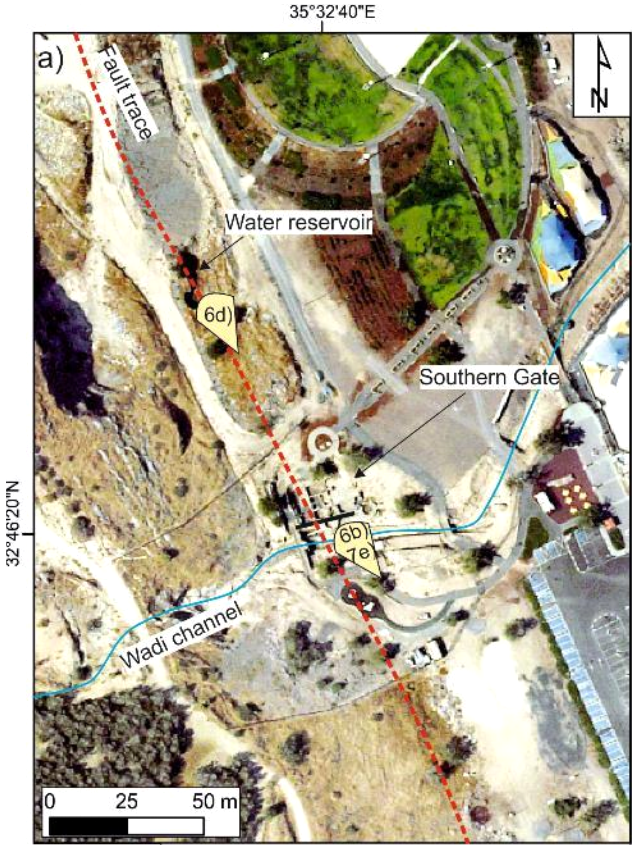 Figure 6a
Map of the Southern Gate and water reservoir sites, ca. 200 m S of the Theatre, along the Jordan Valley Western Boundary (JVWB) Fault strike, with indication of picture view angles and trace of total station profile. Fault trace is marked by red dashed line
Ferrario et al (2020)
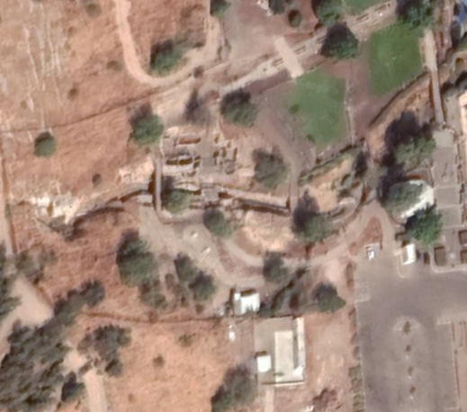
- Fig. 1 Aerial view of the
southern gate and surroundings from Hartal (2010)
 Figure 1
Aerial view of the excavation area
Hartal (2010) - Fig. B Roman Gate and
courtyard-house of the Fatimid period from Cytryn-Silverman (2015)
Figure B
Roman Gate and courtyard-house of the Fatimid period abutting the west tower at Berko Park
Photo by David Silverman, The New Tiberias Excavation Project.
Cytryn-Silverman (2015) - The Southern Gate in Tiberias in Google Earth
 The Southern Gate in Tiberias
click on image to explore this site on a new tab in Google Earth - The Southern Gate in Tiberias on govmap.gov.il
The Southern Gate in Tiberias
click on image to explore this site on a new tab in govmap.gov.il
- Fig. 14 Proposed reconstruction
of the ancient city of Tiberias from Hirschfeld and Galor (2007) and Atrash (2012)
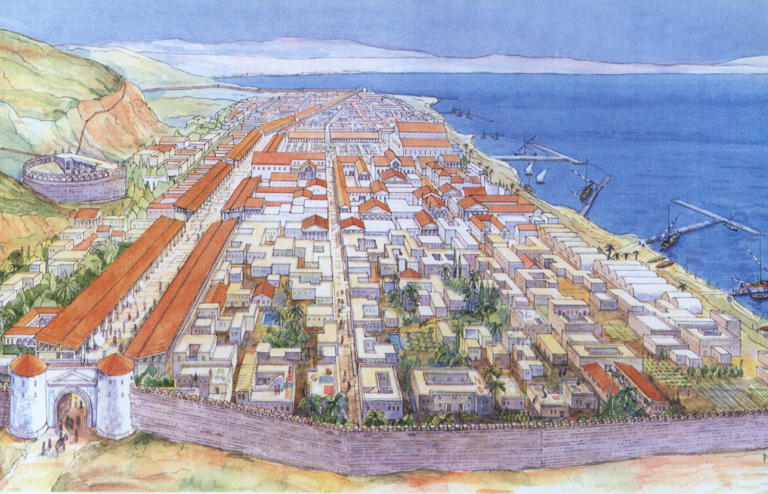 Figure 14
Proposed reconstruction of the ancient city of Tiberias, looking north
(drawn by Dov Porotzky)
Caption from Hirschfeld and Galor (2007) and image from Atrash (2012)
| Effect | Location | Image(s) | Description |
|---|---|---|---|
| Warped and Folded Wall | Byzantine Wall - under the wood bridge Roman Gate with warped Byzantine wall area highlighted in red
Photo by David Silverman, The New Tiberias Excavation Project. Modified by JW from Cytryn-Silverman (2015)  Figure 6 b
view of the Byzantine wall at the Southern Gate site Ferrario et al (2020) |
 Figure 6 c
detail of the warped Byzantine wall. The wooded frame, holding the pedestrian bridge, is situated above the fault line. The dashed black line marks a down throw of an originally horizontal datum Ferrario et al (2020)  Figure 7a
JW: Topographic Profile across the southern Gate. View from the N. Plotted on a vertical scale with vertical exaggeration of ~4x. Only the Southern gate profile is shown in this extraction. Modified by JW from Ferrario et al (2020) |
|
| Vault Collapse | west of south gate, south of the city wall, and north of the wadi Roman Gate Area with area of vault collapse highlighted in pink
Photo by David Silverman, The New Tiberias Excavation Project. Modified by JW from Cytryn-Silverman (2015) |
 Figure 5
The inside of the city wall from the Byzantine period, looking north (in front of the wall, columns from the Umayyad period). Hartal et al. (2010) |
|
- Fig. 6a Map of Southern
Gate and water reservoir from Ferrario et al (2020)
Figure 6a
Map of the Southern Gate and water reservoir sites, ca. 200 m S of the Theatre, along the Jordan Valley Western Boundary (JVWB) Fault strike, with indication of picture view angles and trace of total station profile. Fault trace is marked by red dashed line
Ferrario et al (2020) - Fig. B Roman Gate and
courtyard-house of the Fatimid period from Cytryn-Silverman (2015)
Figure B
Roman Gate and courtyard-house of the Fatimid period abutting the west tower at Berko Park
Photo by David Silverman, The New Tiberias Excavation Project.
Cytryn-Silverman (2015) - Fig. 6b Annotated Photo of
Southern Gate from Ferrario et al (2020)
Figure 6 b
view of the Byzantine wall at the Southern Gate site
Ferrario et al (2020) - Fig. 6c Warping of Byzantine
wall from Ferrario et al (2020)
Figure 6 c
detail of the warped Byzantine wall. The wooded frame, holding the pedestrian bridge, is situated above the fault line. The dashed black line marks a down throw of an originally horizontal datum
Ferrario et al (2020) - Fig. 7 a-e Total Station
profiles of sites in Ancient Tiberias from Ferrario et al (2020)
 Figure 7
a) Topographic profiles obtained with a total station showing the vertical displacement across the studied fault at Tiberias Theatre and the Southern Gate. Each profile is plotted on a relative vertical scale with a vertical exaggeration of ca. 4x
b-e) photos of the measured points at Theatre (b-d) and Southern Gate (e), colored dots represent shooting points.
Ferrario et al (2020) - Fig. 7 e Total Station
profile of the Southern Gate from Ferrario et al (2020)
 Figure 7e) photo of the measured points at the Southern Gate, colored dots represent shooting points
Ferrario et al (2020)
The Southern Gate is built on a bedrock (Cretaceous limestone), which outcrops at the base of the wadi channel which runs in a general E-W direction within the site. Displacement at the Southern Gate is represented by warping of a Byzantine E-W wall, archaeologically dated at ca. 530 CE1 (Fig. 6 b
Figure 6 b) view of the Byzantine wall at the Southern Gate site
Ferrario et al (2020)
Figure 6 c) detail of the warped Byzantine wall. The wooded frame, holding the
pedestrian bridge, is situated above the fault line. The dashed black line marks a down throw of
an originally horizontal datum
Ferrario et al (2020)
Figure 7a) Topographic profiles obtained with a total station showing the vertical displacement across the studied fault at Tiberias Theatre and the Southern Gate. Each profile is plotted on a relative vertical scale with a vertical exaggeration of ca. 4x
b-e) photos of the measured points at Theatre (b-d) and Southern Gate (e), colored dots represent shooting points.
Ferrario et al (2020)
Figure 7e) photo of the measured points at the Southern Gate, colored dots represent shooting points
Ferrario et al (2020)
- Modified by JW from Fig. B of Cytryn-Silverman (2015)
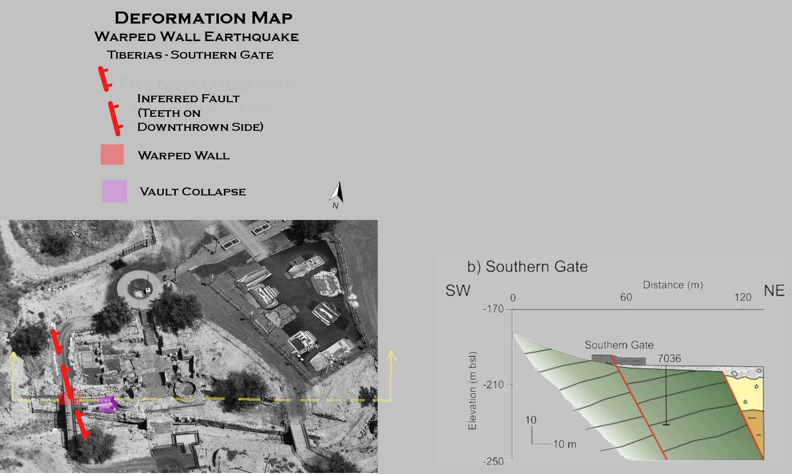 Deformation Map
click on image to open in a new tab
Modified by JW from Fig. B of Cytryn-Silverman (2015)
- Earthquake Archeological Effects chart
of Rodríguez-Pascua et al (2013: 221-224)
 Earthquake Archeological Effects (EAE)
Rodríguez-Pascua et al (2013: 221-224)
| Effect | Location | Image(s) | Description | Intensity |
|---|---|---|---|---|
| Warped and Folded Wall | Byzantine Wall - under the wood bridge
Roman Gate with warped Byzantine wall area highlighted in red Photo by David Silverman, The New Tiberias Excavation Project. Modified by JW from Cytryn-Silverman (2015)
Figure 6 bview of the Byzantine wall at the Southern Gate site Ferrario et al (2020) |
Figure 6 c detail of the warped Byzantine wall. The wooded frame, holding the pedestrian bridge, is situated above the fault line. The dashed black line marks a down throw of an originally horizontal datum Ferrario et al (2020)
Figure 7aJW: Topographic Profile across the southern Gate. View from the N. Plotted on a vertical scale with vertical exaggeration of ~4x. Only the Southern gate profile is shown in this extraction. Modified by JW from Ferrario et al (2020) |
|
VII+ |
| Vault Collapse | west of south gate, south of the city wall, and north of the wadi
Roman Gate Area with area of vault collapse highlighted in pink Photo by David Silverman, The New Tiberias Excavation Project. Modified by JW from Cytryn-Silverman (2015) |
Figure 5 The inside of the city wall from the Byzantine period, looking north (in front of the wall, columns from the Umayyad period). Hartal et al. (2010) |
|
VIII+ |