Jerash - Umayyad Mosque
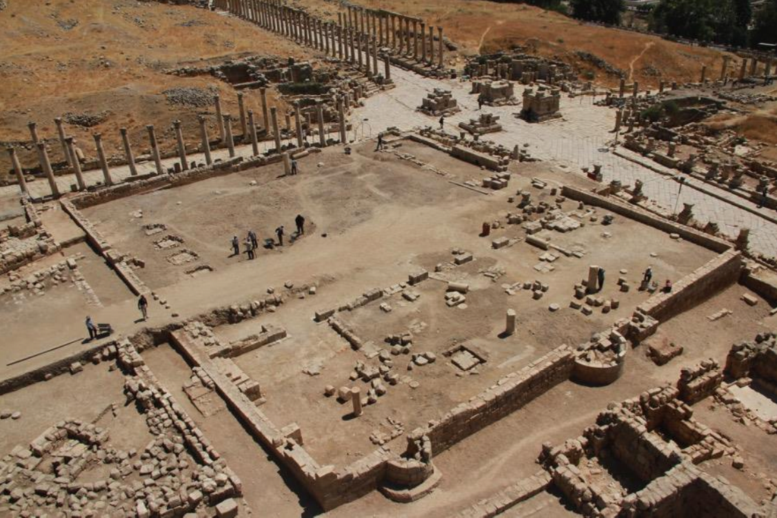 Figure 5
Excavated Congregational Mosque at Jerash
JW: View from the south. The Qiblat wall and its three mihrabs are in the foreground
Rattenborg and Blanke (2017)
- Fig. 16.5 - Two
Mihrabs
from Walmsley (2018)
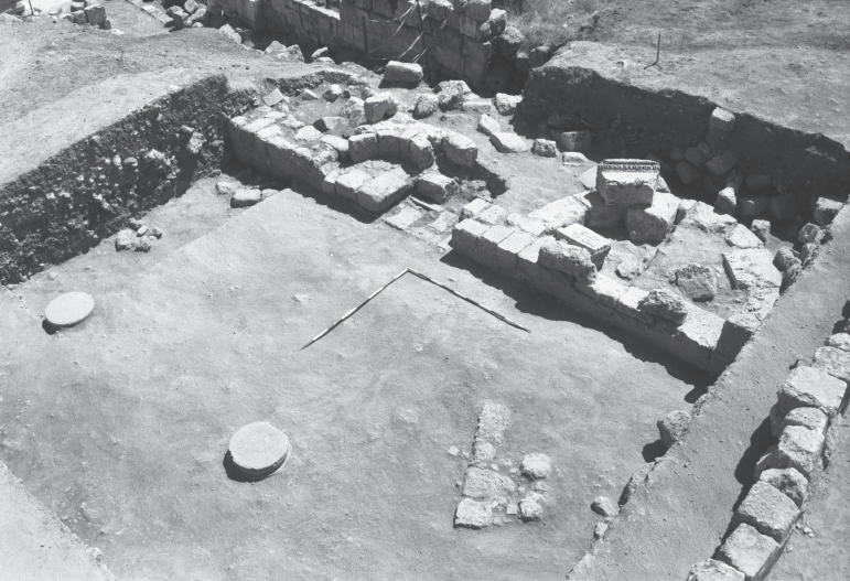 Figure 16.5
The 2002 photo graph of the main (umayyad) miḥrāb of the congregational mosque of Jerash in Phase 1 (c. AD 725–40), with the partially preserved smaller and later Phase 2 (c. mid-eighth to early eleventh centuries) miḥrāb to its left (east). In the foreground are reused column bases that served as foundations for the first colonnade that ran parallel to the qiblat wall of the prayer hall
(Islamic Jarash Project/ Department of antiquities of Jordan, IJP_B&W-360).
Walmsley (2018) - Fig. 16.6 - The smaller
Mihrab
from Walmsley (2018)
 Figure 16.6
The southern (external) face of the umayyad miḥrāb following stratigraphic excavations, showing the foundations and skilled stone working by the masons. to the right, a long series of street surfaces are preserved that date to the use of the mosque; the later date of the smaller Phase-2 miḥrāb can be seen in the way it sits on top of surfaces contemporary with the original Phase-1 mosque and its miḥrāb
(Islamic Jarash Project/ Department of antiquities of Jordan, IJP_B&W-360).
Walmsley (2018)
Walmsley (2018:248-250) dates initial construction of the Umayyad Congregational Mosque to between ca. 725 and ca. 735 CE indicating that it was built during the reign of Hisham b. ‘Abd al-Malik who ruled from 724-743 CE. The presence of 3 Mihrabs indicates that the mosque had a long life with at least three major stages ( Walmsley and Damgaard, 2005). The larger Mihrab in the center of the Qiblat Wall was used first followed by a smaller one ~1-2 meters to the east (see Fig. 16.5). The smaller second Mihrabs (Fig. 16.6) appears to post date seismic destruction in 749 CE. Blanke et al (2010) noted that the third Mihrab is located well to the west where it was
segregated by a perdition wall. The Mosque was built on top of an earlier structure - a bathhouse.
- Jerash Umayyad Mosque in Google Earth
 Jerash Umayyad Mosque
click on image to explore this site on a new tab in Google Earth
- General Plan of Jerash
from Wikipedia
- Fig. 2 - Plan of Umayyad
Jerash from Walmsley and Daamgaard (2005)

Figure 2
Plan summarising the principal urban features of Umayyad Jarash.
- Umayyad mosque
- possible Islamic administrative centre
- market (suq)
- South Tetrakonia piazza (built over)
- Macellum, with Umayyad–Abbasid rebuilding, and south cardo, encroached by structures;
- Oval piazza domestic quarter with fountain;
- Zeus temple forecourt (kiln, monastery?)
- hippodrome and Bishop Marianos church, eighth century use
- church of SS Peter and Paul and Mortuary Church (Umayyad construction date?)
- churches of SS Cosmas and Damianus, St George and St John theBaptist, with Umayyad–Abbasid occupation and iconoclastic-effected mosaics (later eighth century)
- Christian complex of two churches (Cathedral to the east with stairs from the street, St Theodore’s to the west), mid-5th to late 6th century Bath of Placcus (north of St Theodore’s) and houses west of St Theodore’s with extensive Umayyad occupation including a kiln and oil press
- Artemis compound used for ceramic manufacture
- Synagogue church with iconoclastic-effected mosaics
- North Theatre, also industrialised with kilns
- the 1981 ‘mosque’
- central Cardo with blacksmith’s shop and offices
Map modfied from R.E. Pillen in Zayadine (1986).
Walmsley and Daamgaard (2005) - Fig. 13 - Early Islamic
Jerash - 8th to 13th century CE - from Rattenborg and Blanke (2017)
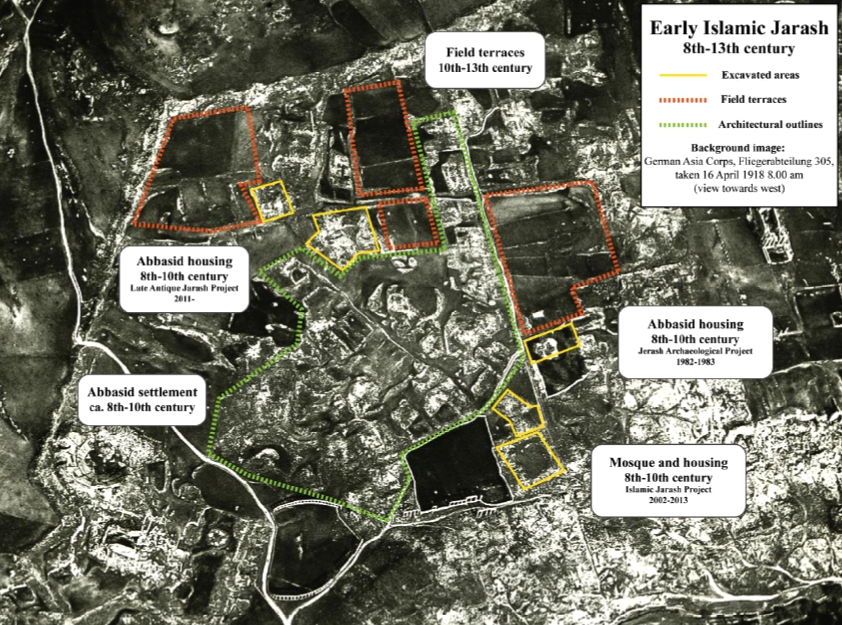 Figure 13
Early Islamic Jerash
8th to 13th century CE
Rattenborg and Blanke (2017) - Fig. 1 - Plan of Jerash
showing location of the town's bathhouses from Blanke et al. (2024b)
 Fig. 1
Jerash archaeological site, showing location of the town's bathhouses
(Modified from map by Thomas Lepaon.)
Blanke et al. (2024b)

- Fig. 2 - Plan of Umayyad
Jerash from Walmsley and Daamgaard (2005)
Figure 2
Plan summarising the principal urban features of Umayyad Jarash.
- Umayyad mosque
- possible Islamic administrative centre
- market (suq)
- South Tetrakonia piazza (built over)
- Macellum, with Umayyad–Abbasid rebuilding, and south cardo, encroached by structures;
- Oval piazza domestic quarter with fountain;
- Zeus temple forecourt (kiln, monastery?)
- hippodrome and Bishop Marianos church, eighth century use
- church of SS Peter and Paul and Mortuary Church (Umayyad construction date?)
- churches of SS Cosmas and Damianus, St George and St John theBaptist, with Umayyad–Abbasid occupation and iconoclastic-effected mosaics (later eighth century)
- Christian complex of two churches (Cathedral to the east with stairs from the street, St Theodore’s to the west), mid-5th to late 6th century Bath of Placcus (north of St Theodore’s) and houses west of St Theodore’s with extensive Umayyad occupation including a kiln and oil press
- Artemis compound used for ceramic manufacture
- Synagogue church with iconoclastic-effected mosaics
- North Theatre, also industrialised with kilns
- the 1981 ‘mosque’
- central Cardo with blacksmith’s shop and offices
Map modfied from R.E. Pillen in Zayadine (1986).
Walmsley and Daamgaard (2005) - Fig. 13 - Early Islamic
Jerash - 8th to 13th century CE - from Rattenborg and Blanke (2017)
Figure 13
Early Islamic Jerash
8th to 13th century CE
Rattenborg and Blanke (2017) - Fig. 1 - Plan of Jerash
showing location of the town's bathhouses from Blanke et al. (2024b)
Fig. 1
Jerash archaeological site, showing location of the town's bathhouses
(Modified from map by Thomas Lepaon.)
Blanke et al. (2024b)
- Fig. 3 - Plan of Congregational
Mosque from Walmsley and Daamgaard (2005)
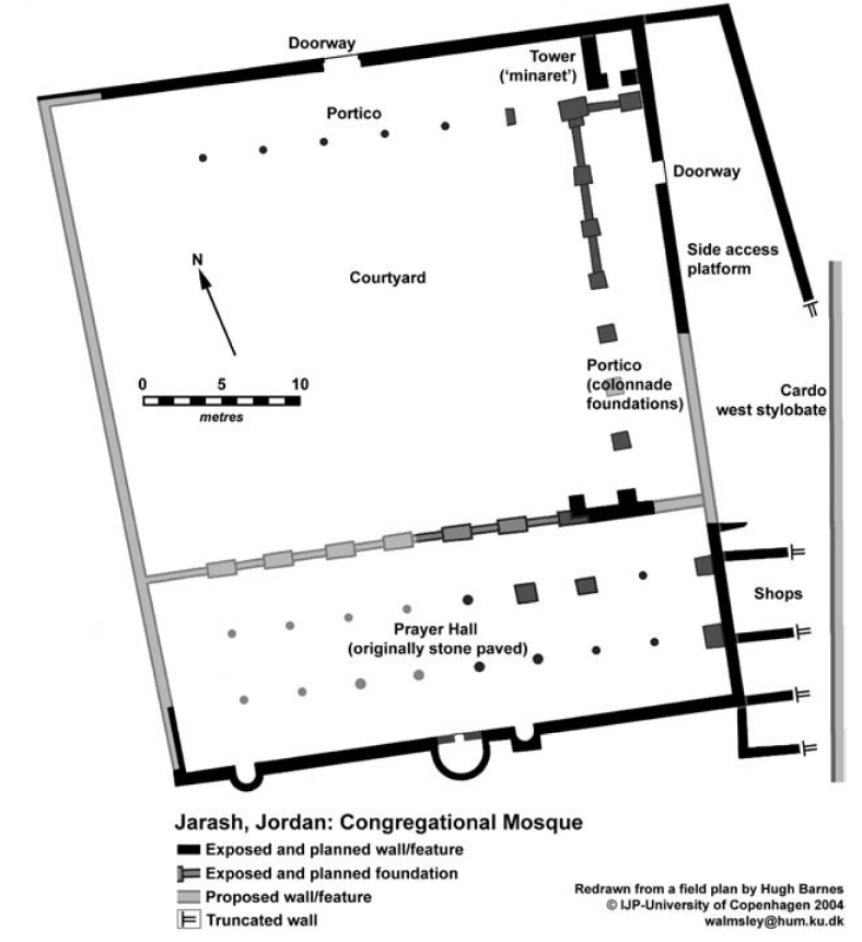 Figure 3
Preliminary outline plan of the Umayyad mosque of Jarash (as after 2004 season).
Walmsley and Daamgaard (2005) - Fig. 4 - Plan of Congregational
Mosque with excavation areas from Barnes et al (2006)
 Figure 4
Plan of the mosque, showing excavated areas to 2004
Barnes et al (2006)
- Fig. 3 - Plan of Congregational
Mosque from Walmsley and Daamgaard (2005)
Figure 3
Preliminary outline plan of the Umayyad mosque of Jarash (as after 2004 season).
Walmsley and Daamgaard (2005) - Fig. 4 - Plan of Congregational
Mosque with excavation areas from Barnes et al (2006)
Figure 4
Plan of the mosque, showing excavated areas to 2004
Barnes et al (2006)
- Fig. 6 - Early Islamic
Jerash - Early 8th century CE - from Rattenborg and Blanke (2017)
 Figure 6
Early Islamic Jerash
Early 8th century CE
Rattenborg and Blanke (2017) - Fig. 7 - Early Islamic
Jerash - ca. 750-850 CE - from Rattenborg and Blanke (2017)
 Figure 7
Early Islamic Jerash
ca. 750-850 CE
Rattenborg and Blanke (2017) - Fig. 10 - Early Islamic
Jerash - ca. 850-950 CE - from Rattenborg and Blanke (2017)
 Figure 10
Early Islamic Jerash
ca. 850-950 CE
Rattenborg and Blanke (2017) - Fig. 11 - Early Islamic
Jerash - ca. 950-1000 CE - from Rattenborg and Blanke (2017)
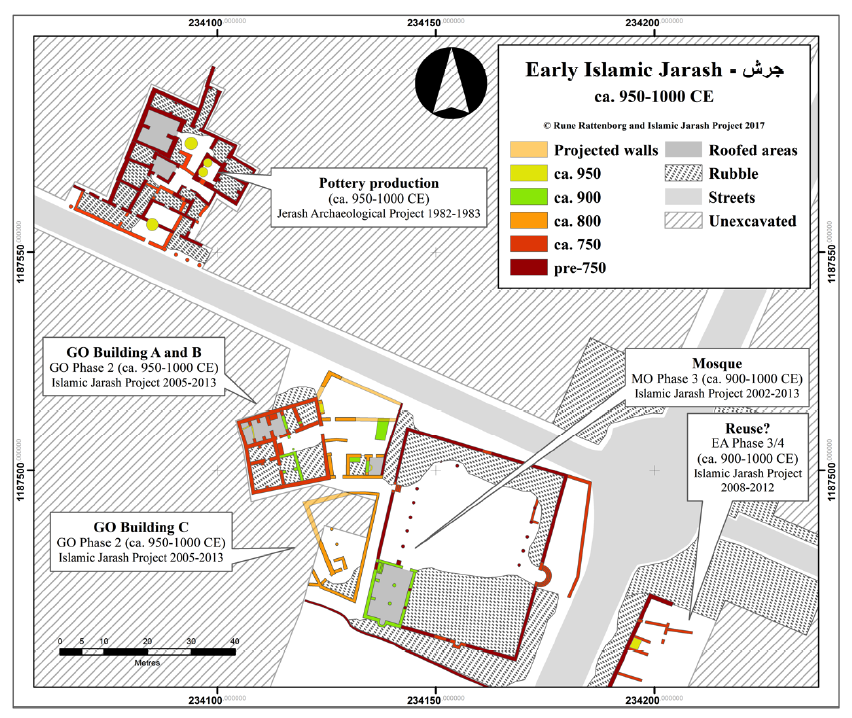 Figure 11
Early Islamic Jerash
ca. 950-1000 CE
Rattenborg and Blanke (2017) - Fig. 16.8 - Early Islamic
Jerash - ca. 800-1000 CE - from Walmsley (2018)
 Figure 16.8
Jerash congregational mosque, Phase 2, with surrounding structures of contemporary date (areas GO and EA Phase 3 = mosque Phase 2), dated mid-eighth to mid-tenth centuries AD, with some evidence of use into the early eleventh century AD
(plan by Rune Rattenborg, incorporating material previously published in Gawlikowski 1986; Kraeling 1938a; Simpson 2008a).
Walmsley (2018)
- Fig. 6 - Early Islamic
Jerash - Early 8th century CE - from Rattenborg and Blanke (2017)
Figure 6
Early Islamic Jerash
Early 8th century CE
Rattenborg and Blanke (2017) - Fig. 7 - Early Islamic
Jerash - ca. 750-850 CE - from Rattenborg and Blanke (2017)
Figure 7
Early Islamic Jerash
ca. 750-850 CE
Rattenborg and Blanke (2017) - Fig. 10 - Early Islamic
Jerash - ca. 850-950 CE - from Rattenborg and Blanke (2017)
Figure 10
Early Islamic Jerash
ca. 850-950 CE
Rattenborg and Blanke (2017) - Fig. 11 - Early Islamic
Jerash - ca. 950-1000 CE - from Rattenborg and Blanke (2017)
Figure 11
Early Islamic Jerash
ca. 950-1000 CE
Rattenborg and Blanke (2017) - Fig. 16.8 - Early Islamic
Jerash - ca. 800-1000 CE - from Walmsley (2018)
Figure 16.8
Jerash congregational mosque, Phase 2, with surrounding structures of contemporary date (areas GO and EA Phase 3 = mosque Phase 2), dated mid-eighth to mid-tenth centuries AD, with some evidence of use into the early eleventh century AD
(plan by Rune Rattenborg, incorporating material previously published in Gawlikowski 1986; Kraeling 1938a; Simpson 2008a).
Walmsley (2018)
- Fig. 3 - Islamic Jerash Project
Excavation Areas 2002-2013 from Rattenborg and Blanke (2017)
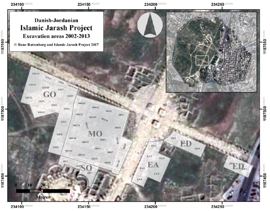 Figure 3
Islamic Jerash Project Excavation Areas 2002-2013
Rattenborg and Blanke (2017) - Fig. 1 - Square numbers for
2009 Islamic Jerash Project Excavations from Blanke et al (2010)
 Figure 1
Overview of Islamic Jarash Project following excavations in 2009 (by Hugh Barnes).
Blanke et al (2010) - Fig. 1 - Square numbers for
2007 Islamic Jerash Project Excavations from Walmsley et al (2008)
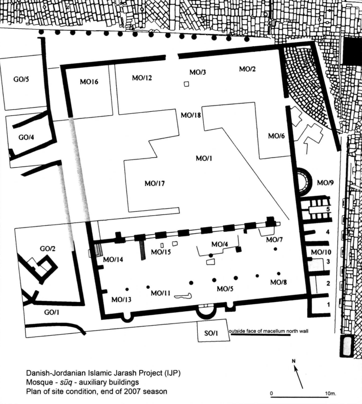 Figure 1
General plan of the excavations in central Jarash, to end of 2007 season
(Barnes mod. Walmsley)
Walmsley et al (2008)
- Fig. 3 - Islamic Jerash Project
Excavation Areas 2002-2013 from Rattenborg and Blanke (2017)
Figure 3
Islamic Jerash Project Excavation Areas 2002-2013
Rattenborg and Blanke (2017) - Fig. 1 - Square numbers for
2009 Islamic Jerash Project Excavations from Blanke et al (2010)
Figure 1
Overview of Islamic Jarash Project following excavations in 2009 (by Hugh Barnes).
Blanke et al (2010) - Fig. 1 - Square numbers for
2007 Islamic Jerash Project Excavations from Walmsley et al (2008)
Figure 1
General plan of the excavations in central Jarash, to end of 2007 season
(Barnes mod. Walmsley)
Walmsley et al (2008)
- Fig. 2 - Plan of the
Central Bathhouses from Blanke et al. (2024b)
 Fig. 2
Plan of the Central Bathhouses highlighting location of latrine and bathhouse sewers
(Plan by Louise Blanke)
Blanke et al. (2024b) - Fig. 3 - Aerial View
of latrine in Central Bathhouse from Blanke et al. (2024b)
 Fig. 3
Overview of latrine in Central Bathhouse looking west.
(© Islamic Jarash Project.)
Blanke et al. (2024b)
- Fig. 2 - Plan of the
Central Bathhouses from Blanke et al. (2024b)
Fig. 2
Plan of the Central Bathhouses highlighting location of latrine and bathhouse sewers
(Plan by Louise Blanke)
Blanke et al. (2024b) - Fig. 3 - Aerial View
of latrine in Central Bathhouse from Blanke et al. (2024b)
Fig. 3
Overview of latrine in Central Bathhouse looking west.
(© Islamic Jarash Project.)
Blanke et al. (2024b)
- Fig. 3 - Fallen Column atop
crushed roof tile fragments from Walmsley et al (2008)
 Figure 3
A fallen column shaft resting on stone paving of the floor in the mosque hall, with roof tile fragments crushed between the column and paving
JW: The excavators interpreted this on page 111 to be the result of what was left after salvaging activities.
Walmsley et al (2008) - Fig. 16.5 - Two
Mihrabs
from Walmsley (2018)
Figure 16.5
The 2002 photo graph of the main (umayyad) miḥrāb of the congregational mosque of Jerash in Phase 1 (c. AD 725–40), with the partially preserved smaller and later Phase 2 (c. mid-eighth to early eleventh centuries) miḥrāb to its left (east). In the foreground are reused column bases that served as foundations for the first colonnade that ran parallel to the qiblat wall of the prayer hall
(Islamic Jarash Project/ Department of antiquities of Jordan, IJP_B&W-360).
Walmsley (2018) - Fig. 16.6 - The smaller
Mihrab
from Walmsley (2018)
Figure 16.6
The southern (external) face of the umayyad miḥrāb following stratigraphic excavations, showing the foundations and skilled stone working by the masons. to the right, a long series of street surfaces are preserved that date to the use of the mosque; the later date of the smaller Phase-2 miḥrāb can be seen in the way it sits on top of surfaces contemporary with the original Phase-1 mosque and its miḥrāb
(Islamic Jarash Project/ Department of antiquities of Jordan, IJP_B&W-360).
Walmsley (2018) - Fig. 8 - North wall of GO
building B from Rattenborg and Blanke (2017)
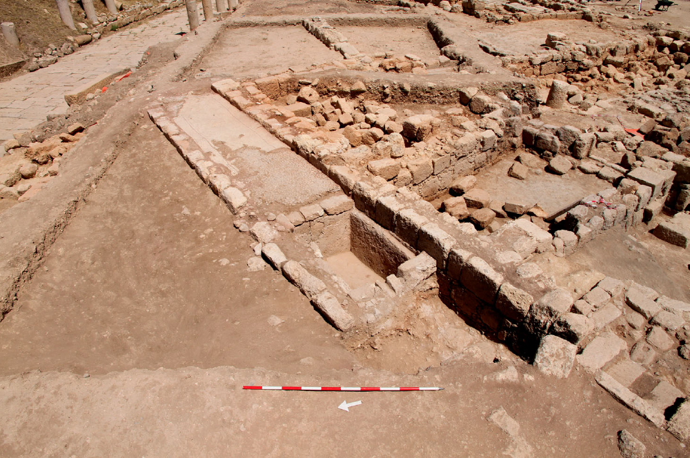 Figure 8
Raised bench with mosaic floor paving and adjoining basin along north wall of GO Building B during excavations in 2013, view facing east (IJP_D_15356)
(© Islamic Jarash Project 2017)
Rattenborg and Blanke (2017) - Qibla wall and three mihrabs
- photo by JW
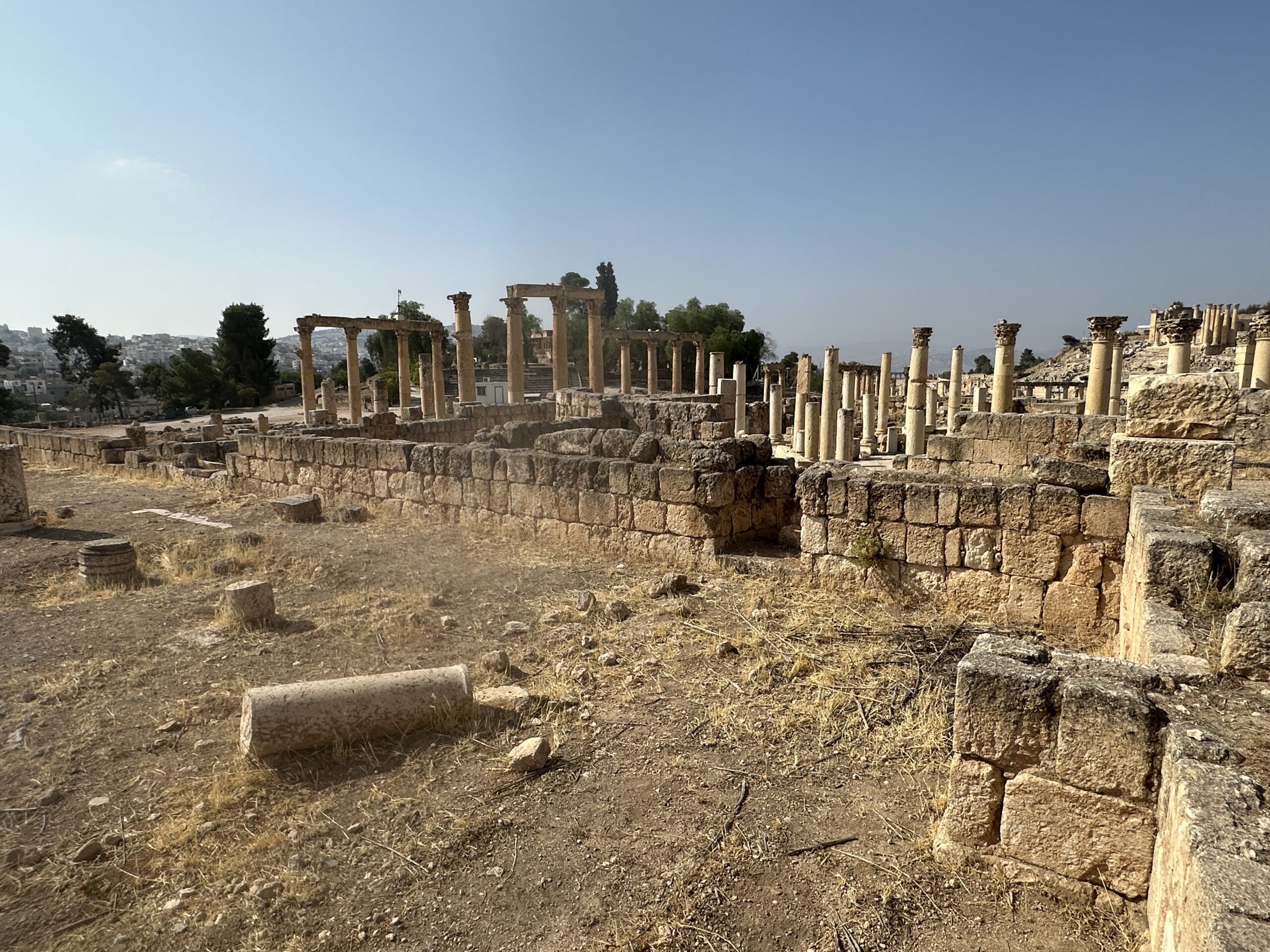 Qibla Wall with Mihrabs
Overview of the qibla wall at the Umayyad Mosque in Jerash showing all three visible mihrabs.
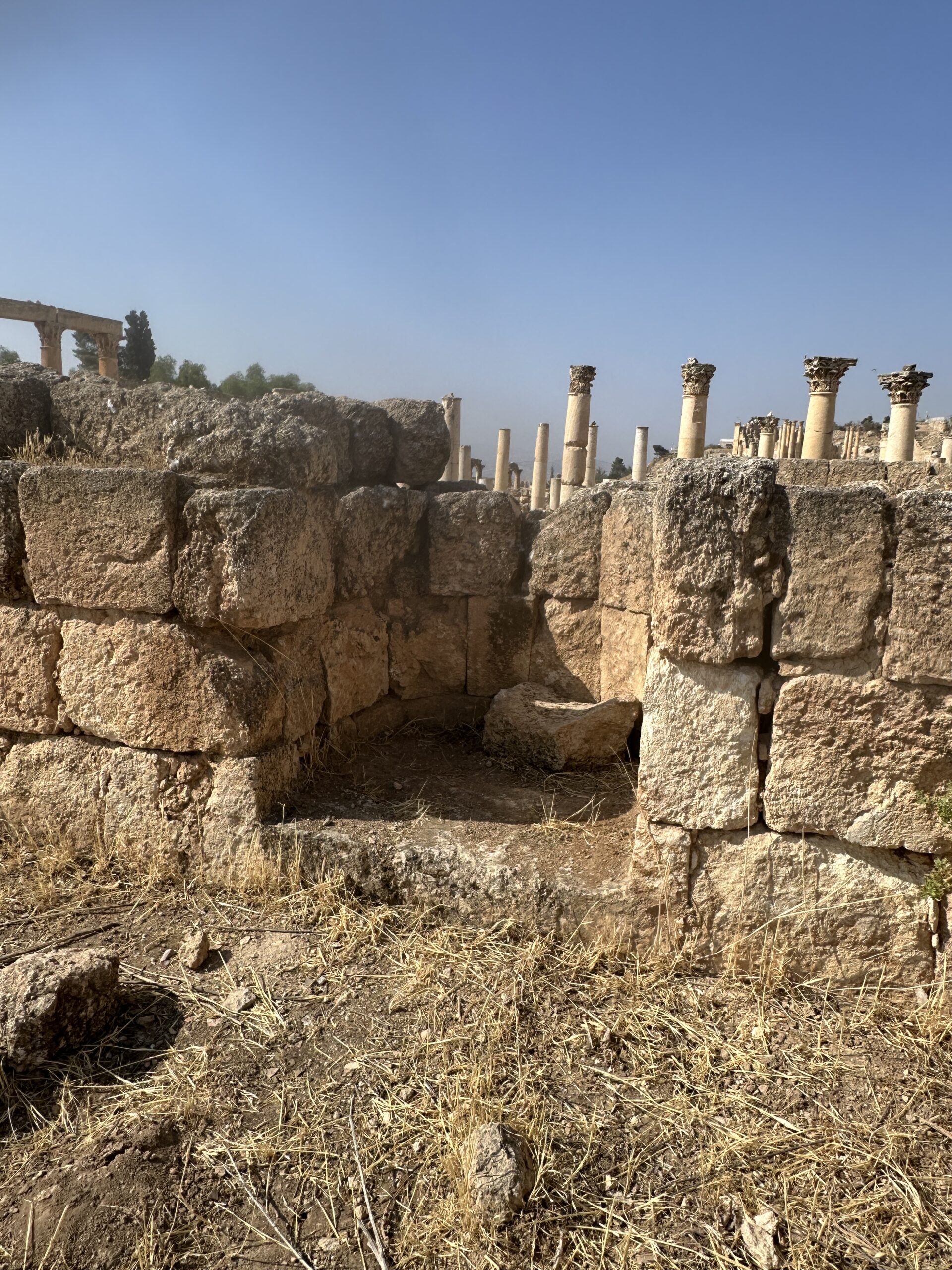
Photo by Jefferson Williams - 23 June 2025 - First two mihrabs - photo by
JW
 First Two Mihrabs
Closer view of the Phase 1 and Phase 2 mihrabs in the Umayyad Mosque at Jerash.
Photo by Jefferson Williams - 23 June 2025 - Third mihrab - photo by JW
 Third Mihrab
View of the third mihrab along the qibla wall at the Umayyad Mosque in Jerash.
Photo by Jefferson Williams - 23 June 2025
- Fig. 3 - Fallen Column atop
crushed roof tile fragments from Walmsley et al (2008)
Figure 3
A fallen column shaft resting on stone paving of the floor in the mosque hall, with roof tile fragments crushed between the column and paving
JW: The excavators interpreted this on page 111 to be the result of what was left after salvaging activities.
Walmsley et al (2008) - Fig. 16.5 - Two
Mihrabs
from Walmsley (2018)
Figure 16.5
The 2002 photo graph of the main (umayyad) miḥrāb of the congregational mosque of Jerash in Phase 1 (c. AD 725–40), with the partially preserved smaller and later Phase 2 (c. mid-eighth to early eleventh centuries) miḥrāb to its left (east). In the foreground are reused column bases that served as foundations for the first colonnade that ran parallel to the qiblat wall of the prayer hall
(Islamic Jarash Project/ Department of antiquities of Jordan, IJP_B&W-360).
Walmsley (2018) - Fig. 16.6 - The smaller
Mihrab
from Walmsley (2018)
Figure 16.6
The southern (external) face of the umayyad miḥrāb following stratigraphic excavations, showing the foundations and skilled stone working by the masons. to the right, a long series of street surfaces are preserved that date to the use of the mosque; the later date of the smaller Phase-2 miḥrāb can be seen in the way it sits on top of surfaces contemporary with the original Phase-1 mosque and its miḥrāb
(Islamic Jarash Project/ Department of antiquities of Jordan, IJP_B&W-360).
Walmsley (2018) - Fig. 8 - North wall of GO
building B from Rattenborg and Blanke (2017)
Figure 8
Raised bench with mosaic floor paving and adjoining basin along north wall of GO Building B during excavations in 2013, view facing east (IJP_D_15356)
(© Islamic Jarash Project 2017)
Rattenborg and Blanke (2017) - Qibla wall and three mihrabs
- photo by JW
Qibla Wall with Mihrabs
Overview of the qibla wall at the Umayyad Mosque in Jerash showing all three visible mihrabs.
Photo by Jefferson Williams - 23 June 2025 - First two mihrabs - photo by
JW
First Two Mihrabs
Closer view of the Phase 1 and Phase 2 mihrabs in the Umayyad Mosque at Jerash.
Photo by Jefferson Williams - 23 June 2025 - Third mihrab - photo by JW
Third Mihrab
View of the third mihrab along the qibla wall at the Umayyad Mosque in Jerash.
Photo by Jefferson Williams - 23 June 2025
- Fig. 16.8 - Early Islamic Jerash
- ca. 800-1000 CE - from Walmsley (2018)
Figure 16.8
Jerash congregational mosque, Phase 2, with surrounding structures of contemporary date (areas GO and EA Phase 3 = mosque Phase 2), dated mid-eighth to mid-tenth centuries AD, with some evidence of use into the early eleventh century AD
(plan by Rune Rattenborg, incorporating material previously published in Gawlikowski 1986; Kraeling 1938a; Simpson 2008a).
Walmsley (2018)
Walmsley (2018:251) discussed the Sūq
The discovery of a row of shops along the eastern wall of the Phase-2 mosque (above), and in them a number of marble tablets with shopkeepers’ accounts in proficient Arabic, revealed the central role played by the mosque in the daily operation of the marketplace.Walmsley (2018:251) discussed the Residential Complex
To the west of the mosque, separated from it by a narrow street (fig. 16.8), a large residential complex has been exposed that existed well before the construction of the mosque and continued as residences, with successive modifications, contemporaneously with the mosque. The three courtyard buildings uncovered were constructed around a network of streets and directly connected to the mosque by way of doorways in the west enclosure wall, thereby revealing that this residential quarter was fully integrated in the life of the mosque, most notably in Phase 2
| Effect | Location | Image(s) | Description |
|---|---|---|---|
|
GO area - two rooms in the northern wing of Building B and subsurface compartment around the cistern shaft in the courtyard of the same structure
(note that Building B is to the west of building A) Early Islamic Jerash ca. 750-850 CE Rattenborg and Blanke (2017) Early Islamic Jerash ca. 950-1000 CE Rattenborg and Blanke (2017) Islamic Jerash Project Excavation Areas 2002-2013 Rattenborg and Blanke (2017) Overview of Islamic Jarash Project following excavations in 2009 (by Hugh Barnes). Blanke et al (2010) |
Fig. 8
Raised bench with mosaic floor paving and adjoining basin along north wall of GO Building B during excavations in 2013, view facing east (IJP_D_15356) (© Islamic Jarash Project 2017) Rattenborg and Blanke (2017) |
|
|
GO area - laneway between the mosque west wall and Building A, eastern interior of Building A, and possibly square GO/6 (note that Building B is to the west of building A) Early Islamic Jerash ca. 750-850 CE Rattenborg and Blanke (2017) Early Islamic Jerash ca. 950-1000 CE Rattenborg and Blanke (2017) Islamic Jerash Project Excavation Areas 2002-2013 Rattenborg and Blanke (2017) Overview of Islamic Jarash Project following excavations in 2009 (by Hugh Barnes). Blanke et al (2010) |
Fig. 15
GO/6 at the end of the 2009 season, seen from the west. Note the cistern drain in the bottom of the picture (by IJP). Blanke et al (2010) |
|
|
Congregational Mosque - qiblat Hall
Figure 4 Plan of the mosque, showing excavated areas to 2004 Barnes et al (2006)
Figure 3Preliminary outline plan of the Umayyad mosque of Jarash (as after 2004 season). Walmsley and Daamgaard (2005) Islamic Jerash Project Excavation Areas 2002-2013 Rattenborg and Blanke (2017) Overview of Islamic Jarash Project following excavations in 2009 (by Hugh Barnes). Blanke et al (2010)
Figure 1General plan of the excavations in central Jarash, to end of 2007 season (Barnes mod. Walmsley) Walmsley et al (2008) |
|
- Modified by JW from Fig. 12 of Rattenborg and Blanke (2017)
Click on image top open in a new tab
Modified by JW from Fig. 12 of Rattenborg and Blanke (2017)
-
Earthquake Archeological Effects chart
of Rodríguez-Pascua et al (2013: 221-224)
 Earthquake Archeological Effects (EAE)
Rodríguez-Pascua et al (2013: 221-224)
| Effect | Location | Image(s) | Description | Intensity |
|---|---|---|---|---|
|
GO area - two rooms in the northern wing of Building B and subsurface compartment around the cistern shaft in the courtyard of the same structure
(note that Building B is to the west of building A) Early Islamic Jerash ca. 750-850 CE Rattenborg and Blanke (2017) Early Islamic Jerash ca. 950-1000 CE Rattenborg and Blanke (2017) Islamic Jerash Project Excavation Areas 2002-2013 Rattenborg and Blanke (2017) Overview of Islamic Jarash Project following excavations in 2009 (by Hugh Barnes). Blanke et al (2010) |
Fig. 8
Raised bench with mosaic floor paving and adjoining basin along north wall of GO Building B during excavations in 2013, view facing east (IJP_D_15356) (© Islamic Jarash Project 2017) Rattenborg and Blanke (2017) |
|
VIII+ (collapsed walls) |
|
GO area - laneway between the mosque west wall and Building A, eastern interior of Building A, and possibly square GO/6 (note that Building B is to the west of building A) Early Islamic Jerash ca. 750-850 CE Rattenborg and Blanke (2017) Early Islamic Jerash ca. 950-1000 CE Rattenborg and Blanke (2017) Islamic Jerash Project Excavation Areas 2002-2013 Rattenborg and Blanke (2017) Overview of Islamic Jarash Project following excavations in 2009 (by Hugh Barnes). Blanke et al (2010) |
Fig. 15
GO/6 at the end of the 2009 season, seen from the west. Note the cistern drain in the bottom of the picture (by IJP). Blanke et al (2010) |
|
VIII+ (collapsed walls) |
|
Congregational Mosque - qiblat Hall
Figure 4 Plan of the mosque, showing excavated areas to 2004 Barnes et al (2006)
Figure 3Preliminary outline plan of the Umayyad mosque of Jarash (as after 2004 season). Walmsley and Daamgaard (2005) Islamic Jerash Project Excavation Areas 2002-2013 Rattenborg and Blanke (2017) Overview of Islamic Jarash Project following excavations in 2009 (by Hugh Barnes). Blanke et al (2010)
Figure 1General plan of the excavations in central Jarash, to end of 2007 season (Barnes mod. Walmsley) Walmsley et al (2008) |
|
VIII+ (collapsed walls) |