Tel Jezreel
 Tel Jezreel
click on image to explore this site on a new tab in govmap.gov.il
| Transliterated Name | Source | Name |
|---|---|---|
| Jezreel | Hebrew | יִזְרְעֶאל |
| Tel Jezreel | Hebrew | |
| Zir'in | Arabic | زرعين |
| Zerein | Arabic | زرعين |
| le Petit Gerin | French (Crusader) | |
| Gezrael | Latin | |
| Iezrael | Latin | |
| Parvum Gerinum | Latin | |
| Esdraela | | |
| Zarain | |
- Fig. 3 Tel Jezreel and environs
in Classical and Early Medieval periods from Moorhead (1997)

Fig. 3
Tel Jezreel and environs in Classical and Early Mediaeval periods (Note: many of the locations are only approximate).
Key
- COL=Columbarium
- MS=Milestone (approximate findspot)
- TAN=Tannery(?)
- BC=Byzantine Cistern in general area
- MON=War Memorial Monument
Sarcophagi
- Sl=findspot known
- (S9)=general area
- S3=fragment used in later construction
Rock-Cut Tombs
- 1=located
- RC2=reported but unlocated or destroyed
Wine-Presses
- WP1=still visible
- WP3=unlocated
- WT6=white tessellated floor
Moorhead (1997)
- Fig. 3 Tel Jezreel and environs
in Classical and Early Medieval periods from Moorhead (1997)
Fig. 3
Tel Jezreel and environs in Classical and Early Mediaeval periods (Note: many of the locations are only approximate).
Key
- COL=Columbarium
- MS=Milestone (approximate findspot)
- TAN=Tannery(?)
- BC=Byzantine Cistern in general area
- MON=War Memorial Monument
Sarcophagi
- Sl=findspot known
- (S9)=general area
- S3=fragment used in later construction
Rock-Cut Tombs
- 1=located
- RC2=reported but unlocated or destroyed
Wine-Presses
- WP1=still visible
- WP3=unlocated
- WT6=white tessellated floor
Moorhead (1997)
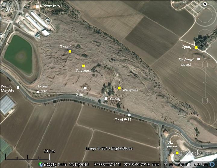
- Annotated Satellite Photo of Tel
Tel Jezreel from BibleWalks.com
- Tel Jezreel in Google Earth
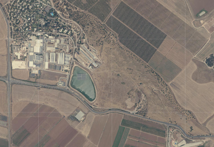
 Tel Jezreel
click on image to explore this site on a new tab in Google Earth - Tel Jezreel on govmap.gov.il
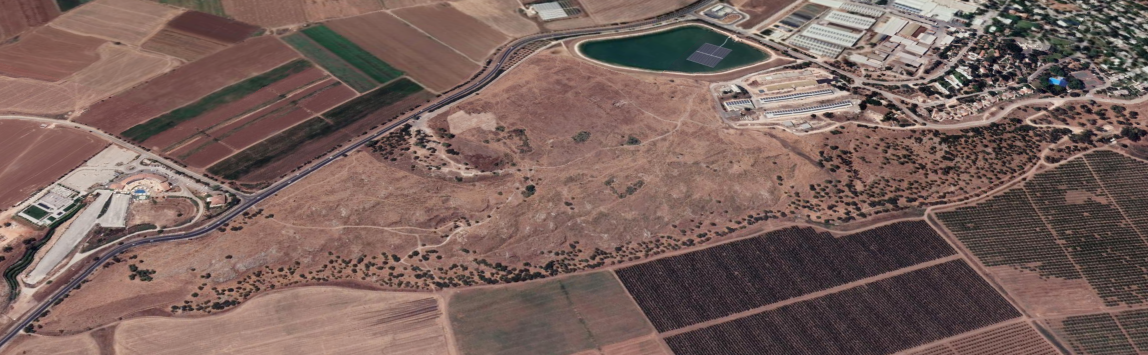
Tel Jezreel
click on image to explore this site on a new tab in govmap.gov.il
- Annotated Satellite Photo of Tel
Tel Jezreel from BibleWalks.com
- Tel Jezreel in Google Earth
Tel Jezreel
click on image to explore this site on a new tab in Google Earth - Tel Jezreel on govmap.gov.il
Tel Jezreel
click on image to explore this site on a new tab in govmap.gov.il
- Fig. 3 Tel Jezreel and environs
in Classical and Early Medieval periods from Moorhead (1997)
Fig. 3
Tel Jezreel and environs in Classical and Early Mediaeval periods (Note: many of the locations are only approximate).
Key
- COL=Columbarium
- MS=Milestone (approximate findspot)
- TAN=Tannery(?)
- BC=Byzantine Cistern in general area
- MON=War Memorial Monument
Sarcophagi
- Sl=findspot known
- (S9)=general area
- S3=fragment used in later construction
Rock-Cut Tombs
- 1=located
- RC2=reported but unlocated or destroyed
Wine-Presses
- WP1=still visible
- WP3=unlocated
- WT6=white tessellated floor
Moorhead (1997)
- Fig. 4 Late Roman, Byzantine and
Umayyad features excavated or surveyed in the area of the Iron Age enclosure from Moorhead (1997)
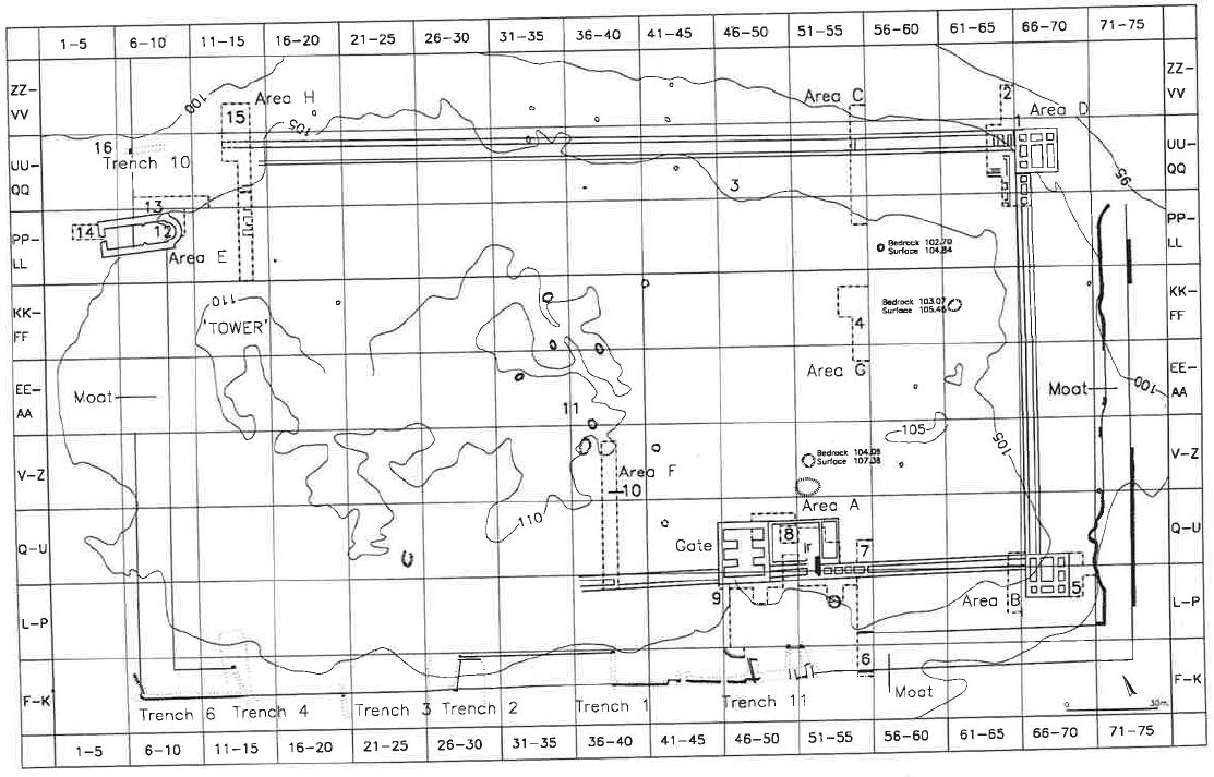
Fig. 4
Late Roman, Byzantine and Umayyad features excavated or surveyed in the area of the Iron Age enclosure:
- Byzantine retaining wall in Area D (see Fig. 5)
- Structural remains in Area D
- Wine-press 5 (see Figs. 10-13)
- Structural remains in Area G (see Fig. 8)
- Structural remains in Area B
- Byzantine floor in Iron Age moat
- Remains in Area A
- Structural remains in Area A.1
- Structural remains in Area A3
- Structural remains in Area F
- Bath-house(?)
- Area E — remains inside the church
- Area E — remains in probe trench in Sq. QQ/8
- Area E — remains in front of the church
- Structural remains in Area H; 16. Sarcophagus No. 1.
Moorhead (1997)
- Fig. 4 Late Roman, Byzantine and
Umayyad features excavated or surveyed in the area of the Iron Age enclosure from Moorhead (1997)
Fig. 4
Late Roman, Byzantine and Umayyad features excavated or surveyed in the area of the Iron Age enclosure:
- Byzantine retaining wall in Area D (see Fig. 5)
- Structural remains in Area D
- Wine-press 5 (see Figs. 10-13)
- Structural remains in Area G (see Fig. 8)
- Structural remains in Area B
- Byzantine floor in Iron Age moat
- Remains in Area A
- Structural remains in Area A.1
- Structural remains in Area A3
- Structural remains in Area F
- Bath-house(?)
- Area E — remains inside the church
- Area E — remains in probe trench in Sq. QQ/8
- Area E — remains in front of the church
- Structural remains in Area H; 16. Sarcophagus No. 1.
Moorhead (1997)
- Fig. 36 Area E: General plan of
church and excavations around it from Ussishkin and Woodhead (1997)
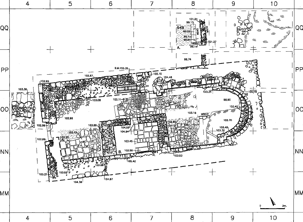 Fig. 36
Area E: General plan of church and excavations around it
(Squares 00/3 and QQ/11-12 are not shown).
- The probe trench excavated in 1991-1993
- Arab structure
- Base of Kibbutz Yisre'el generator
Ussishkin and Woodhead (1997)
- Fig. 36 Area E: General plan of
church and excavations around it from Ussishkin and Woodhead (1997)
Fig. 36
Area E: General plan of church and excavations around it
(Squares 00/3 and QQ/11-12 are not shown).
- The probe trench excavated in 1991-1993
- Arab structure
- Base of Kibbutz Yisre'el generator
Ussishkin and Woodhead (1997)
- Fig. 38 Bedrock fissure
from Ussishkin and Woodhead (1997)
 Fig. 38
Area E. The projection in the inner rock-cut wall of the moat exposed beneath the apse of the church, from southwest. Note the fissure across the rock projection at the bottom right corner of the picture.
Ussishkin and Woodhead (1997) - Fig. 38 Bedrock fissure
(AI enhanced) from Ussishkin and Woodhead (1997)
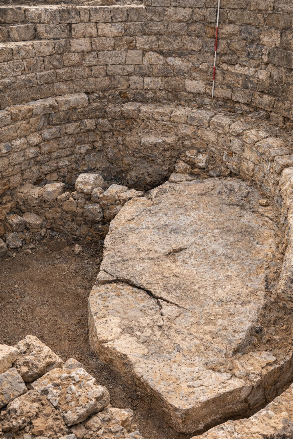 Fig. 38
Area E. The projection in the inner rock-cut wall of the moat exposed beneath the apse of the church, from southwest. Note the fissure across the rock projection at the bottom right corner of the picture.
Enhanced with AI
click on image to open in a new tab Ussishkin and Woodhead (1997)
- Fig. 38 Bedrock fissure
from Ussishkin and Woodhead (1997)
Fig. 38
Area E. The projection in the inner rock-cut wall of the moat exposed beneath the apse of the church, from southwest. Note the fissure across the rock projection at the bottom right corner of the picture.
Ussishkin and Woodhead (1997) - Fig. 38 Bedrock fissure
(AI enhanced) from Ussishkin and Woodhead (1997)
Fig. 38
Area E. The projection in the inner rock-cut wall of the moat exposed beneath the apse of the church, from southwest. Note the fissure across the rock projection at the bottom right corner of the picture.
Enhanced with AI
click on image to open in a new tab
Ussishkin and Woodhead (1997)
- Annotated Satellite Photo of Tel
Tel Jezreel from BibleWalks.com
- Fig. 3 Tel Jezreel and environs
in Classical and Early Medieval periods from Moorhead (1997)
Fig. 3
Tel Jezreel and environs in Classical and Early Mediaeval periods (Note: many of the locations are only approximate).
Key
- COL=Columbarium
- MS=Milestone (approximate findspot)
- TAN=Tannery(?)
- BC=Byzantine Cistern in general area
- MON=War Memorial Monument
Sarcophagi
- Sl=findspot known
- (S9)=general area
- S3=fragment used in later construction
Rock-Cut Tombs
- 1=located
- RC2=reported but unlocated or destroyed
Wine-Presses
- WP1=still visible
- WP3=unlocated
- WT6=white tessellated floor
Moorhead (1997) - Fig. 4 Late Roman, Byzantine and
Umayyad features excavated or surveyed in the area of the Iron Age enclosure from Moorhead (1997)
Fig. 4
Late Roman, Byzantine and Umayyad features excavated or surveyed in the area of the Iron Age enclosure:
- Byzantine retaining wall in Area D (see Fig. 5)
- Structural remains in Area D
- Wine-press 5 (see Figs. 10-13)
- Structural remains in Area G (see Fig. 8)
- Structural remains in Area B
- Byzantine floor in Iron Age moat
- Remains in Area A
- Structural remains in Area A.1
- Structural remains in Area A3
- Structural remains in Area F
- Bath-house(?)
- Area E — remains inside the church
- Area E — remains in probe trench in Sq. QQ/8
- Area E — remains in front of the church
- Structural remains in Area H; 16. Sarcophagus No. 1.
Moorhead (1997) - Fig. 36 Area E: General plan of
church and excavations around it from Ussishkin and Woodhead (1997)
Fig. 36
Area E: General plan of church and excavations around it
(Squares 00/3 and QQ/11-12 are not shown).
- The probe trench excavated in 1991-1993
- Arab structure
- Base of Kibbutz Yisre'el generator
Ussishkin and Woodhead (1997)
- Fig. 38 Bedrock fissure
from Ussishkin and Woodhead (1997)
Fig. 38
Area E. The projection in the inner rock-cut wall of the moat exposed beneath the apse of the church, from southwest. Note the fissure across the rock projection at the bottom right corner of the picture.
Ussishkin and Woodhead (1997)