Tall Zira'a
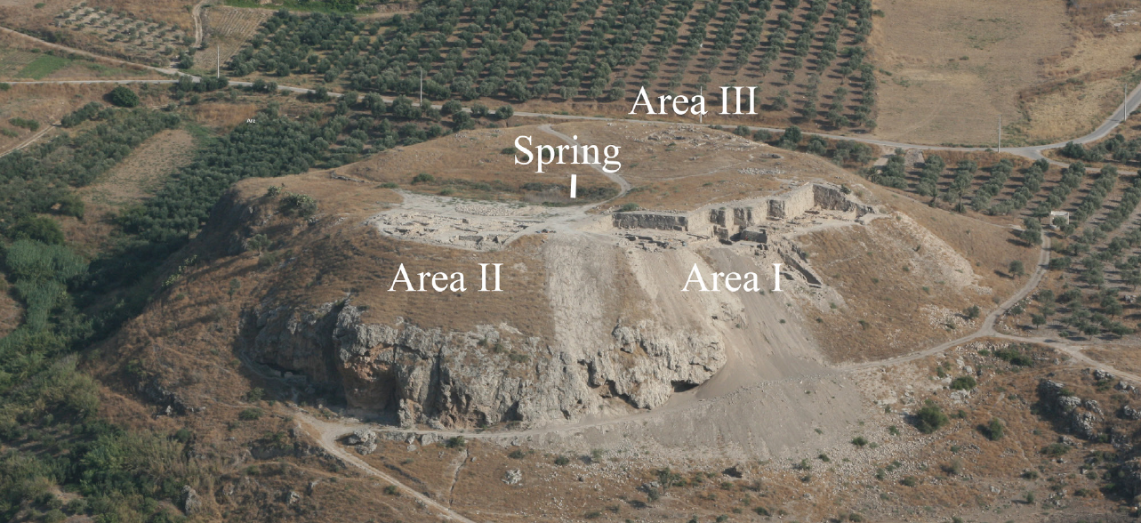 Fig. 1.28
Tall Zirā‘a. View from north to south. Overview with the Areas I, II and III. Photograph taken in 2011 (Source: BAI/GPIA).
Vieweger and Häser (2017)
| Transliterated Name | Language | Name |
|---|---|---|
| Tall Zira'a | Arabic | تالل زيرا'ا |
- Fig. 0.3 - Location Map from
Vieweger and Häser (2017:28)
 Figure 0.3
Tall Zirā‘a and its geographic location
(Source: BAI/GPIA)
Vieweger and Häser (2017)
- Tall Zira'a in Google Earth
 Tall Zira'a
click on image to explore this site on a new tab in Google Earth
- Fig. 1.32 - Site plan from
Vieweger and Häser (2017:28)
 Figure 1.32
General Plan of the excavation area on Tall Zira'a (Source: BAI/GPIA)
Vieweger and Häser (2017) - Fig. 2.111 - Survey Squares
of the site from Vieweger and Häser (2017)
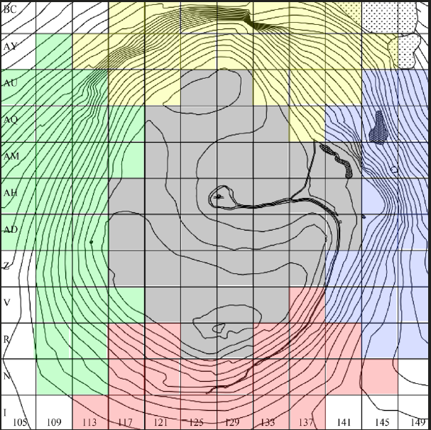 Figure 2.111
Tall Zirā‘a. Survey squares and areas of search:
- north (yellow)
- south (red)
- east (blue)
- west (green)
- plateau (grey)
(Source: BAI/GPIA).
Vieweger and Häser (2017)
- Fig. 1.32 - Site plan from
Vieweger and Häser (2017:28)
Figure 1.32
General Plan of the excavation area on Tall Zira'a (Source: BAI/GPIA)
Vieweger and Häser (2017) - Fig. 2.111 - Survey Squares
of the site from Vieweger and Häser (2017)
Figure 2.111
Tall Zirā‘a. Survey squares and areas of search:
- north (yellow)
- south (red)
- east (blue)
- west (green)
- plateau (grey)
(Source: BAI/GPIA).
Vieweger and Häser (2017)
- Fig. 4.4 - Area I with
excavation squares from Vieweger and Häser (2017)
 Figure 4.4
Area I and its excavation squares (Source: BAI/GPIA)
Vieweger and Häser (2017)
- Fig. 4.4 - Area I with
excavation squares from Vieweger and Häser (2017)
Figure 4.4
Area I and its excavation squares (Source: BAI/GPIA)
Vieweger and Häser (2017)
- Fig. 4.5 - Area II with
excavation squares from Vieweger and Häser (2017)
 Figure 4.5
Area II with its excavation squares (Source: BAI/GPIA)
Vieweger and Häser (2017)
- Fig. 4.5 - Area II with
excavation squares from Vieweger and Häser (2017)
Figure 4.5
Area II with its excavation squares (Source: BAI/GPIA)
Vieweger and Häser (2017)
- Fig. 4.6 - Area III with
excavation squares from Vieweger and Häser (2017)
 Figure 4.6
Area III with its excavation squares (Source: BAI/GPIA)
Vieweger and Häser (2017)
- Fig. 4.6 - Area III with
excavation squares from Vieweger and Häser (2017)
Figure 4.6
Area III with its excavation squares (Source: BAI/GPIA)
Vieweger and Häser (2017)
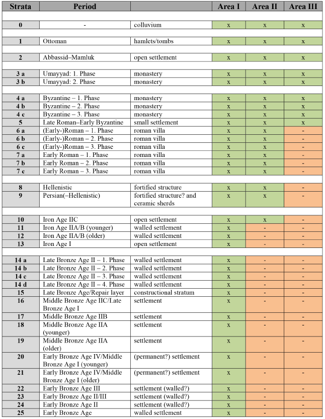 Tab. 4.1
Strata on Tall Zirā‘a in correlation with the periods (Source: BAI/GPIA).
Vieweger and Häser (2017)
- Fig. 1.32 - Site plan from
Vieweger and Häser (2017:28)
Figure 1.32
General Plan of the excavation area on Tall Zira'a (Source: BAI/GPIA)
Vieweger and Häser (2017) - Fig. 1.68 - Landslide on the
east side of the Tell from Vieweger and Häser (2017 v.1:45)
 Fig. 1.68
Tall Zirā‘a. Landslide on the east side. Photograph taken in 2009
(Source: BAI/ GPIA)
Vieweger and Häser (2017 v.1:45)
An undated landslide (Fig. 1.68) is present on the eastern side of the Tel (Vieweger and Häser, 2017:45).
| Effect | Location | Image(s) | Comments |
|---|---|---|---|
| Landslide | western area of the settlement
Figure 1.32 General Plan of the excavation area on Tall Zira'a (Source: BAI/GPIA) Vieweger and Häser (2017) |
a landslide destroyed the western area of the settlement- Vieweger and Häser (2017:11) |
|
| Cave collapse | beneath the settlement layers
Figure 1.32 General Plan of the excavation area on Tall Zira'a (Source: BAI/GPIA) Vieweger and Häser (2017) |
Calcareous sinter caves beneath the settlement layers collapsed- Vieweger and Häser (2017:11) |
| Effect | Location | Image(s) | Comments |
|---|---|---|---|
| Collapsed Walls ? | Monastery consisting of a church and living quarters in Areas I and II
Figure 1.32 General Plan of the excavation area on Tall Zira'a (Source: BAI/GPIA) Vieweger and Häser (2017) |
Although the walls do not show any clear indication of an earthquake, it is highly probable that the destruction of the monastery was caused by the quake in 749. Afterwards, the site was abandoned almost entirely as only few sherds of Abbasid date and the absence of buildings, which can be attributed to this period, indicate- Haser (2025:127) |
- Earthquake Archeological Effects chart
of Rodríguez-Pascua et al (2013: 221-224)
 Earthquake Archeological Effects (EAE)
Rodríguez-Pascua et al (2013: 221-224)
| Effect | Location | Image(s) | Comments | Intensity |
|---|---|---|---|---|
| Landslide | western area of the settlement
Figure 1.32 General Plan of the excavation area on Tall Zira'a (Source: BAI/GPIA) Vieweger and Häser (2017) |
a landslide destroyed the western area of the settlement- Vieweger and Häser (2017:11) |
IV+ | |
| Cave collapse | beneath the settlement layers
Figure 1.32 General Plan of the excavation area on Tall Zira'a (Source: BAI/GPIA) Vieweger and Häser (2017) |
Calcareous sinter caves beneath the settlement layers collapsed- Vieweger and Häser (2017:11) |
III+ |
- Earthquake Archeological Effects chart
of Rodríguez-Pascua et al (2013: 221-224)
Earthquake Archeological Effects (EAE)
Rodríguez-Pascua et al (2013: 221-224)
| Effect | Location | Image(s) | Comments | Intensity |
|---|---|---|---|---|
| Collapsed Walls ? | Monastery consisting of a church and living quarters in Areas I and II
Figure 1.32 General Plan of the excavation area on Tall Zira'a (Source: BAI/GPIA) Vieweger and Häser (2017) |
Although the walls do not show any clear indication of an earthquake, it is highly probable that the destruction of the monastery was caused by the quake in 749. Afterwards, the site was abandoned almost entirely as only few sherds of Abbasid date and the absence of buildings, which can be attributed to this period, indicate- Haser (2025:127) |
VIII+? |