Iron Age in the Southern Levant
 Fig. 4.1
Map of major archaeological and historical site in central and northern Israel and Jordan
Click on Image to open this image in a new tab
Mazar et. al. (2020 v.1)
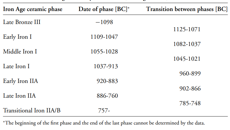 Table 2
Dates of six ceramic phases in the Iron Age in the Levant and the transition between them according to the Bayesian model (63% agreement).
Finkelstein and Piasetzky (2010)

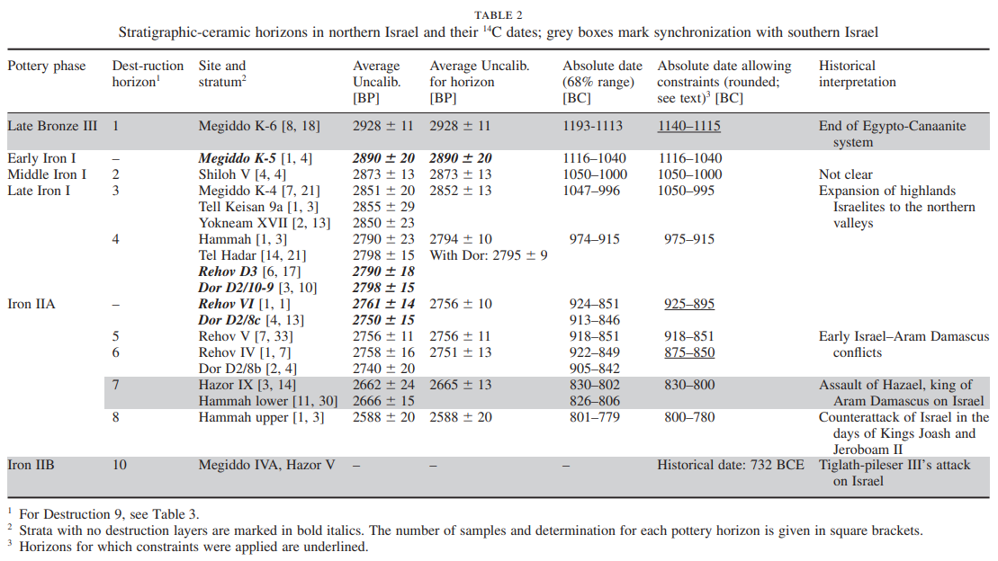 Table 2
Stratigraphic-ceramic horizons in northern Israel and their 14C dates; grey boxes mark synchronization with southern Israel
Finkelstein and Piasetzky (2009)
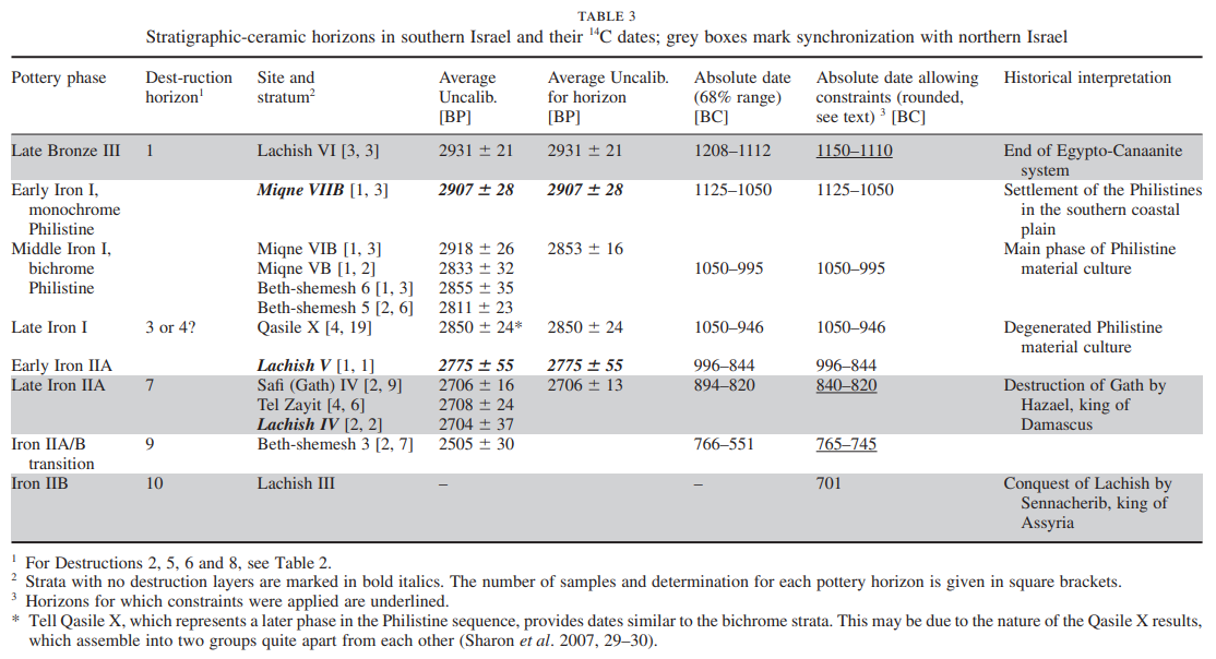 Table 3
Stratigraphic-ceramic horizons in southern Israel and their 14C dates; grey boxes mark synchronization with northern Israel
Finkelstein and Piasetzky (2009)
 Figure 5
Results of the Bayesian model for six phases and six transitions in the Iron Age
Finkelstein and Piasetzky (2010)
- from Mazar (2014)
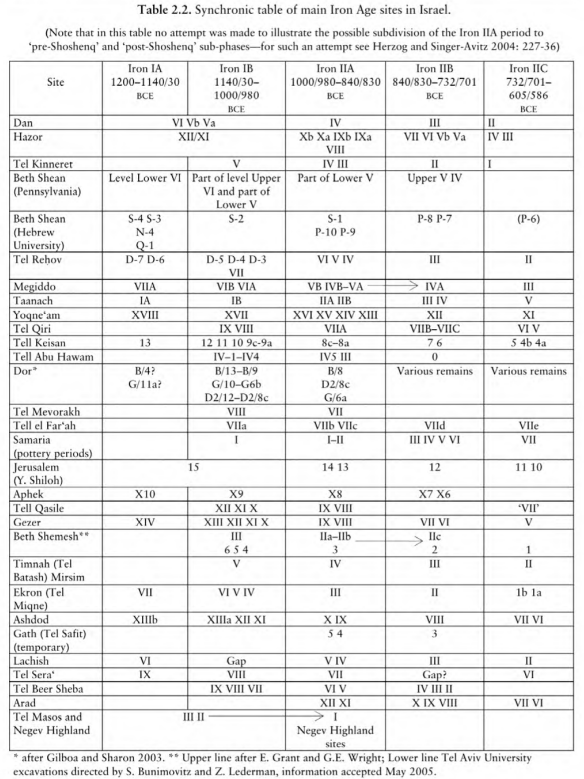 Table 2.2
Synchronic Table of Main Iron Age Sites in Israel
Mazar in Levy and Higham (2014)
 Figure 4
Synchronization of the ten destruction horizons, pottery horizons and historical events (Destruction 2, middle Iron I, Shiloh, not marked).
Finkelstein and Piasetzky (2009)
 Figure 3
The Bayesian model for six phases and six transitions in the Iron Age. Destruction layers are underlined with a thick black line; historical constraints are indicated by arrows. The late Iron IIA strata were entered in the order of the four destruction horizons that we identified elsewhere
(Finkelstein & Piasetzky 2009)
Finkelstein and Piasetzky (2010)
- from Thomas (2014:3-10)
| Period | Time Span (BCE) |
Notes |
|---|---|---|
| Iron I | 1200-1000 | ca. 1005-931 BCE - reigns of Kings David and Solomon |
| Iron IIA | 1000-925 | ~925 BCE - Sheshonoq I's invasion |
| Iron IIB | 925-720 | ~732 BCE - Neo-Assyrian Conquest of Israel (the Northern Kingdom) |
| Iron IIC | 720-586 | ~587 BCE - Neo-Babylonian Conquest of Jerusalem and Destruction of the First Temple |
For much of the history of research into the archaeological and biblically-based historical background of the world of the Hebrew Bible/Old Testament, it was not thought that elements of the nature of the biblical text or the archaeological record of the southern Levant contradicted the general historicity of the United Monarchy and its description as given by the associated biblical books. In two articles published in 1958 and 1970, the noted Israeli archaeologist Yigael Yadin provided the high point in the search for David and Solomon ‘on the ground’. He described how three cities that had undergone major excavations in Israel, some partially under his direction, each produced a monumental casemate wall and city gate that featured three chambers on each side of the main passageway. Each was associated with pottery that was, at least at the time, commonly dated to the 10th century BC. These three cities, Hazor in the northern end of ancient Israel’s highlands, Megiddo in the Jezreel Valley adjoining the upper Mediterranean coastal plain, and Gezer on the southern coastal plain near the region inhabited by Israel’s traditional foes the Philistines, were exactly the three sites that the biblical passage 1 Kings 9:15 describes as having been ‘built’ by Solomon. Megiddo was the crown jewel, with a series of palatial buildings that appeared to be major administrative structures present in the same stratum as the casemate wall and six-chambered gate, followed by a later stratum with a four-chambered gate and what appeared to be large stables, apparently built by the Omride dynasty of the early Northern Kingdom of Israel known for their chariotry. Yadin operated with the assumption that 1 Kings 9:15 could be assumed to be historically accurate, and with the passage alongside the stratigraphy, pottery and gates, his findings appeared to provide clear indication of the sophisticated, monumental, centralised and state-directed activity that characterised Solomon’s kingdom, confirming the biblical impression of his rule1.
Later however, a movement taking place primarily within biblical studies as opposed to archaeology began to radically question the date of the Hebrew Bible/Old Testament as a whole, including those books which describe the United and Divided Monarchies. This movement, primarily located in Britain and continental Europe, reached a crescendo of sorts in the 1990’s. These texts were declared to be late, dating to Persian or even Hellenistic periods, about half a millennium or more later than the events they described. Thus it was declared that the descriptions of the United and Divided Monarchies were, in common with other historical topics of the Hebrew Bible/Old Testament’s authors, essentially a later ideological invention. The biblical portraits of these ancient kingdoms contained little if any historical material and even if they did, it was so bound up in the ideological, nationalistic and rhetorical goals of the authors as to be rendered indistinguishable and useless for a detailed and balanced understanding of ancient Israel. This movement came to be placed involuntarily under the label ‘Minimalism’ and its proponents ‘Minimalists’. Conversely, those who defended the historical integrity of the biblical books and the traditional picture of ancient Israel were dubbed ‘Maximalists’2. These terms have now become well known within the scholarly community, though they are designations placed upon a non-unified and non-self-designating group, and are made within an otherwise complex field that contains as many individual and nuanced views as it does scholars to have them. Thus the idea of ‘Maximalism’ versus ‘Minimalism’ does not concern this thesis. As it is, the ‘Minimalist’ paradigm as sketched out above has been rendered essentially null by the progress of historical, linguistic and archaeological research on ancient Israel and in studies that have addressed the claims and conclusions of the paradigm directly. Important studies of note include research into the diachronic position of the stage of the Hebrew language that was used to write much of the Hebrew Bible/Old Testament that has revealed, primarily through comparison with relevant epigraphic materials of the Iron Age, that the Hebrew used to write much of the Deuteronomistic History, a group of books that includes the books of Samuel and Kings and to which this thesis will return, was written before the Exile of Judah to Babylonia of 586 BC3. Even more important as far as the historicity of the monarchical period are studies such as that of Baruch Halpern and William Dever that explicated and laid out in detail the amount of archaeological and textual evidence from the Hebrew Bible/Old Testament, the archaeology of the southern Levant, and independent evidence and historical references from ancient Israel’s wider ancient Near Eastern world that demonstrated the general historical reliability of the material reality of ancient Israel, such as names and relative chronological setting of kings who are known from both the biblical books and from references to them in ancient Near Eastern documents4. The most definitive piece of evidence that severely undermined an outright rejection of any historicity to the United Monarchy was found in fragments in 1993 and 1994. The Aramaic stele found at Tel-Dan contains a clear reference to the Northern Kingdom of Israel and to the ‘House of David’, a common patronymic way of referring to a kingdom using the founder’s name5.
As such, this thesis does not focus on the scholarship of those often invoked as ‘Minimalist’ because, as described, their more extreme positions have been rendered essentially invalid by the progress of archaeology and by scholarship that has critically examined their claims. Observe Philip Davies’ ‘Critique of Biblical Israel’ from his In Search of ‘Ancient Israel’, in which the author constructs a situation in which the archaeological record of Iron Age civilisation in the southern Levant actually bears no connection to the civilisation and history, the ‘Israel’, described in the Bible6. Davies’ construction is in fact a bizarre form of exceptionalism, in which biblical Israel happens to be different from all other ancient cultures even though it is in fact no different, having a written history and an archaeological record that has been otherwise accepted to be the actual remains of the civilisation that is described by that written history and from which it emerged. Such thinking has now been bypassed by the debate and not a factor in considering its primary focus and the positions of its important contributors. What does concern this thesis emerged first and foremost out of archaeology. Beginning in the mid-1990s, another Israeli archaeologist named Israel Finkelstein ignited an enormous new debate over the historicity of the United Monarchy, the very debate that this thesis examines. In two articles Finkelstein set out to demonstrate what he saw as deep flaws in the structural matrix of the High Chronology. First, Finkelstein argued that one of the bases used for relative dating of sites in the Iron I and IIA, the settlement of the Philistines in southern Canaan, should be down dated from its traditional position in the 12th century BC to the 11th century BC. His argument derived from the fact that though 12th century BC Egyptian sites in southern Canaan were closely proximal to Philistine sites, these sites did not have any Philistine pottery, an apparently odd situation given their locations. Thus the Philistine settlement must not have occurred in the 12th century BC and must have been later than first thought. Finkelstein then went on to critique Yadin’s identification of the ‘Solomonic’ strata and gates described above, which he argued were inherently subjective due to the reliance on the 1 Kings passage, which seemed to him to be the central basis upon which Yadin did his dating. He took the view that the passage’s own date and relevance to the 10th century BC was not known for sure, as opposed to the possibility of it being related to a later period. He also pointed out that the stratigraphic association of the six-chambered gate at Megiddo had been challenged since Yadin’s time. In line with his arguments about the date of the Philistines’ settlement and their pottery, he concluded that the transition from the Iron I into the Iron IIA should be lowered to the end of the 10th century BC and the associated ‘Solomonic’ strata should be down-dated to the very late 10th or early 9th centuries BC. He thus concluded that construction previously attributed to Solomon was much more likely related to the Omride dynasty in the 9th century, thus stripping the Davidic-Solomonic United Monarchy of its monumental architecture as it became a kingdom, if it could still be called that, of the much poorer Iron I, which now occupied most of the 10th century BC. This new chronological system Finkelstein called the ‘Low Chronology’7. In 1997, Amihai Mazar published a critique of Finkelstein’s views, beginning a debate in which he has been one of Finkelstein’s primary sparring partners, which continues to the present8. In 2001 Mazar introduced his own revision of Iron Age Chronology in Israel, which he has come to call the ‘Modified Conventional Chronology’. This scheme is based on Mazar’s observations concerning pottery but instigated by his collaborative radiocarbon dating studies performed on samples from the excavations at Beth Shean and Tel Rehov, where Mazar has served as director. The Modified Conventional Chronology asserts that the transition from the end of Iron I to Iron IIA occurred at c. 980 BC and that the Iron IIA ended c. 830 BC. This kept alive the possibility that the aforementioned monumental building activity could be attributed to the United Monarchy, but left the situation ambiguous9.
Figure 2: Comparisons of the three chronological systems
 Figure 2
Comparisons of the three chronological systems
Thomas (2014)
It is important to note that both Finkelstein and Mazar are first and foremost archaeologists, though they have both addressed what they believe to be the historical implications of archaeological scholarship. This does not mean that those participating in the debate, including those who make important contributions to the primary models for reconstructing the United Monarchy, simply assume that archaeology must be the ‘High Court’, that is to say the final basis of judgement upon which to address the matter of the biblical picture of the United Monarchy. Finkelstein has argued that it can and should be used as such a basis, and this issue will appear when necessary in the chapters of this thesis10.
The debate therefore, as it existed in its early days and as it exists now, can broadly be said to characterise two more or less distinct positions. One, characterised but by no means exclusive to Finkelstein is generally negative about the historicity of the United Monarchy at least as it is portrayed in the biblical text even if it was a real entity of some form while the alternate position is generally positive about the historicity of the United Monarchy even though it seeks to explain its portrayal in the biblical text with critical nuance rather than a naïve total acceptance. These two positions are here simply referred to as ‘models’ as they both use various arguments and bodies of evidence in an attempt to reconstruct a picture of the historical United Monarchy and its relationship to its portrayal in the biblical text.
- Fig. 2 - Strata in
Area H in Megiddo from Finkelstein (2013:9)
 Figure 2
The eastern and southern baulks of Area H at Megiddo, showing different layers and their relative and absolute dates
Finkelstein (2013)
2. Recent Advances in Archaeology
A clarification about chronology is in place here. Our knowledge of the chronology — both relative and absolute — of the Iron Age strata and monuments in the Levant has been truly revolutionized. In terms of relative chronology, intensification of the study of pottery assemblages from secure stratigraphic contexts at sites such as Megiddo and Tel Rehov in the north and Lachish in the south opened the way to establish a secure division of the Iron Age into six ceramic typology phases:
- early and late Iron I (Arie 2006; Finkelstein and Piasetzky 2006)
- early and late Iron IIA (Herzog and Singer-Avitz 2004, 2006; Zimhoni 2004a; A. Mazar et al. 2005; Arie 2013)
- Iron IIB and Iron IIC (Zimhoni 2004b)
- A statistical model based on a large number of radiocarbon determinations: 229 results from 143 samples that came from 38 strata at 18
sites located in both the north and south of Israel (Finkelstein and Piasetzky 2010, based on Sharon et al. 2007 and other studies; Table
1 here3). The radiocarbon results from Israel are the most intensive for such a short period of time and small piece of
land ever presented in the archaeology of the ancient Near East.
 Table 1
Dates of ceramic phases in the Levant and the transition between them according to recent radiocarbon results (based on a Bayesian model, 63 percent agreement between the model and the data)
Finkelstein (2013:7) - A statistical model for a single site — Megiddo: circa 100 radiocarbon determinations from about 60 samples for 10 layers at Megiddo,
which cover circa 600 years between circa 1400 and 800 B.C.E. (Tofolo et al. forthcoming; demonstration in Fig. 2). Megiddo is especially
reliable for such a model because the time span in question features four major destruction layers that produced many organic samples
from reliable contexts. This, too, is unprecedented: no other site has ever produced such a number of results for such a dense
stratigraphic sequence. The general model (table 1) represents a conservative approach for determining the dates. It creates
certain overlaps in the dates of the phases and a fairly broad range for the transition periods. When this model is adapted to
historical reasoning (e.g., the end of Egyptian rule in the Late Bronze III), one gets the following dates, which will be used
in this book (Finkelstein and Piasetzky 2011):
Phase Date Late Bronze III twelfth century until circa 1130 B.C.E. Early Iron I late 12th century and 1st half of the 11th century B.C.E. Late Iron I 2nd half of the 11th century and 1st half of the 10th century B.C.E. Early Iron IIA last decades of the 10th century and the early 9th century B.C.E. Late Iron IIA rest of the 9th century and the early 8th century B.C.E. Iron IIB rest of the 8th century and the early 7th century B.C.E.
Iron Age in ancient Palestine is - at a rough synthesis - marked by 5 major destructive events, that basically distinguish the beginning, the end and its sub-periods, which this essay deals with8. Inside these centuries there are other minor destructions, not necessarily interpreted as outcomes of macro-events and not always related to many different sites.
The first group of destructive events roughly marks the end of the Egyptian-Canaanean system and the beginning of the Iron Age I, within an articulated and strongly differentiated panorama.
Looking at the destructions as archaeological milestones is preferable to follow not the traditional chronology, that termed the first part of 12th century BC “Iron Age IA” (contemporary to the 20th Dynasty in Egypt)9, but the revised one, that refers to it as “Late Bronze III”10. While the chronology and the nature of the initial Philistine settlement in Philistia remains partly disputed11, the continuity of Canaanite and especially Egyptian centers at certain lowland sites such as Megiddo VIIA, Lachish VI, and Beth Shean VI12, points to an attribution of this lapse of time to the preceding cultural period13. The largest and powerful Canaanite city, Hazor14, was indeed destroyed at the end of conventional Late Bronze (§ 3.3.1.), while most of other sites showed a strong continuity almost until the final part of 12th century BC. The end of the control and of the Egyptian presence in Canaan occurred during the reigns of Ramses IV-VI15, with the invasion of the Sea Peoples until ca. 1140-1130 BC. This last date can be alternatively considered the beginning of Iron Age I16 or the passage to Iron Age IB17.
The end of Iron Age I (then the beginning of Iron Age IIA) is probably the most questioned topic in recent years, since its beginning has been strongly lowered by a number of scholars, headed by I. Finkelstein. In spite of a partial disagreement about the absolute dating of the beginning and the end of the period (that seems to be slowly narrowing in these last years)18, it is remarkable that the attribution of single strata to the archaeological periodization it is often the same. Then, if there is not a definitive consensus about when (in absolute dating) and by whom and/or by what some determined settlements were destroyed, conversely there is an agreement about which strata of such sites were destroyed at the end of Iron Age IB/beginning of Iron Age IIA. I just mention a few examples Megiddo VIA (§ 3.1.1.), Tell Qasile X (§ 3.3.2.), Yokneam XVII19, Tell Keisan 9a20.
The Egyptian raid of Pharaoh Shoshenq I to Canaan ca. 925-92021 BC, an event mentioned in 1 Kings 14:25-28 (§ 2.2.2.), has been at length used as chronological peg for the end of Iron Age IIA (see the Conventional Chronology in tab. 1), with several destruction strata along the country traditionally attributed to it. Only recently it has been integrated inside the period (about at its midpoint), without any specific connotation of “epoch marker” (§ 3.2.2.)22.
The third series of destructions is associated to conflicts between Israel and Aram-Damascus throughout the 9th century BC, that, especially in the north, fix the end of Iron Age IIA. This datum, known by the sources (§§ 2.2.3.; 2.3.2.), has been deepened by radiocarbon measurements and comparative study of material culture, strengthening the idea of a long duration for the Iron Age IIA, spreading over both 10th and 9th centuries BC (§ 3.2.2.).
 Table 1
Chronological span of Iron Age IIA as defined by different chronologies, with related definition and proposer.
Fiaccavento (2014)
The historical datum line for transition from Iron Age IIA to Iron Age IIB in the south (especially in Judah) is still under debate: with the lowering of the chronology it was attributed alternatively to the earthquake which occurred in the days of King Uzziah in ca. 760 BC (Jeroboam II in Israel) (§ 3.1.2.), or to the beginning of the 8th century BC, coinciding with military struggles between the reign of Israel and that of Judah, reported also in the Bible (§ 2.2.4.)
The second part of the Iron Age, Iron Age IIB and Iron Age IIC (840/800/760-732/722/70127 and 732/722/701-604/58628 BC respectively), is less disputed, as it rests on solid archaeological and historical ground29. Both the destructive campaigns of conquest carried on by the Assyrian empire in the late 8th century BC (§ 3.2.3.), than those conducted by the neo-Babylonians in late 7th - early 6th centuries BC (§ 3.2.4.) are well attested on the ground, in external historical written sources (§§ 2.3.3 - 2.3.4.) and in Bible too (§§ 2.2.4 - 2.2.5.).
The possibility that an earthquake (or of a series of related earthquakes in the same seismic movement, lasted over a period of several years) was the cause of the severe destruction in many sites at the end of the Iron Age I, was recently reasserted by E.H. Cline57.
The pivotal evidence is the total conflagration of Tell el Mutesellim/Megiddo’s Stratum VIA. Hypothesized since the Thirties by P.L.O. Guy58, it is possible to link this dramatic destruction to an earthquake on the basis of several evidences. The destruction stratum reached a meter of height in many spots. It is composed of thick accumulation of burnt mudbricks and partly burnt vessels, remains of charred materials (burnt roof beams and rows of burned wooden posts) and, overall, articulated human skeletons in various contorted poses, killed by falling structures (fig. 1)59. During the renewed excavations was noticed, in Level K-4, that three walls of the courtyard house there discovered (Building 00/K/10), still standing at a height of over 1 m, were distorted, leaning in opposite direction in a wavy manner, and two of them had vertical cracks too60. One of the warped wall was tilted to both sides 12°-15°61.
 Fig. 1
Megiddo: Stratum VIA, crushed skeleton and pottery in a domestic structure of Area C (Locus 1745)
(after Harrison 2004, fig. 83, 20)
Fiaccavento (2014)
On the other hand, the absence of weapons from this great destruction stratum, reached in every dug part of the site, should support the hypothesis of a non-human related catastrophe62. The radiocarbon dating of this stratum puts the destruction of late IA I Megiddo in the first half of the 10th century BC or ca. 950 BC.
Other centers seemed to have been destroyed by the same natural agent. At Yokneam, stratum XVII, the city of the terminal phase of Iron Age I, came to an end in a great conflagration: a plethora of vessels on top of the floors, buried beneath collapses, up to 1.5 m high, burnt bricks and charred wood63. At Tell Keisan the stratum 9a ended with a conflagration, that in a house of “Chantier B” left over a meter high destruction stratum, derived from the collapse of walls and ceilings64. At Kinneret/Tell el-cOreme, on the northwestern shores of the Lake of Galilee, clear earthquake traces appear in Stratum V, with structures found bent and displaced, especially in area S where a mudbrick wall collapsed uphill into two rooms, burying a nearly complete household inventory, and evidence of fire is frequent65. The Phoenician town of Dor (Stratum G-7) seems to be possible destroyed by the same natural agent, since in one of the houses was found a heap of fallen stones that sealed half a dozen storage jars and a complete skeleton of a woman, about 40 years old, killed apparently when the structure collapsed66. Tel Hadar/Sheikh Khadr too, on the eastern shore of the Sea of Galilee, met total annihilation at the end of the flourishing Stratum IV - Iron IB, and the three adjacent public buildings exposed (a storehouse, a tripartite pillared building and a granary) were covered by thick layers of burnt bricks and wood, sealing a large amount of complete vessels (about 120)67. Tel Rehov/Tell es-Sarem Stratum VI seems to be not violently destroyed, yet thick mudbrick debris and the poor preservations of the walls of Building A in Area C (local phase C-2), showing signs of brick slippage and cracks, hint at destruction or severe damage which could have been caused by earthquake68. Finally69, at Tell Qasile most of the public buildings of Stratum X were fiercely destroyed by fire and collapsed on themselves (§ 3.3.2.). Nonetheless the distance in between these sites and the difficult stratigraphic correlation among them suggest a cautious approach to this “earthquake swarm hypothesis” for the end of Iron Age I.
Hazor, the “head of all the Canaanite kingdoms”, the largest Bronze Age city in Southern Canaan, was violently destroyed at the end of the conventional Late Bronze Age, in the second half of the 13th century BC ca.139. The fall of the city occurred in two successive moments. After a first phase (Stratum 1B=XIV) of decline and partial dismissing of some important architectural features of public buildings, the Canaanite Hazor was definitively destroyed at the end of the successive stratum (1A=XIII)140 and deserted for a certain period of time141. It was resettled in a rather poor settlement during Iron Age I (Strata XII/XI)142 The city gates in Areas P and K went out of use already at the end of Stratum 1B, whereas all the major public buildings reached their final and violent destruction at the end of the successive Stratum 1A. In the lower city (Area H), the Orthostats Temple was retrieved filled by a clear destruction level of fallen stones, burnt material, broken cultic vessels and beheaded statues of kings and gods (fig. 2)143. In the Stelae Temple (in Area C) too, was found a decapitated statue of a deity, in spite of the absence of clear-cut signs of conflagration144. On the other hand in the upper city both the Podium Complex (Area M) and the Ceremonial Palace145 (Area A) were destroyed in a fierce fire, and retrieved totally covered and sealed by the thick destruction debris. This last was characterized by thick layers of ashes, burnt wooden beams, cracked basalt slabs, vitrified mudbricks, fallen walls and mutilated basalt statues146. Y. Yadin believed that the LBA city’s destruction had to be ascribed to the Israelite troops of Joshua (§ 2.2.1.)147. Lately the (Proto) Israelites were listed as one of the possible responsible of the downfall of the Canaanite Hazor by A. Ben-Tor, together with Egyptians, Sea People and Canaanites148. It cannot be any definitive evidence, since the only written source about the end of the Canaanite Hazor is the Bible, and it is internally controversial too (§ 2.2.1.).
 Fig. 2
Hazor: Holy of the Holies 2113 (Stratum 1A) in the Orthostats Temple in Area H; bowls and basalt mutilated statue as discovered in layer of ashes under the debris
(after Yadin et al. 1961, pl. CXXIII:2)
Fiaccavento (2014)
The heavy destruction of the Philistine Qasile X was traditionally attributed to the conquest of David149, and dated on the basis of this hypothesis to ca. 1000-980 BC. While the radiocarbon results obtained by samples from the destruction layer can support this dating150, the archaeological evidence points to a natural disaster, more than a human one151. In Area A, the residential and industrial quarter was recovered largely destroyed, with deep burnt fillings and large amounts di complete vessels in situ152. In Area C, the main cult structure of the city, building 131, was destroyed in a fierce conflagration, leaving a destruction layer of mudbrick debris, plaster fragments and charred beams from the collapsed wooden roof, thick up to 80 cm, with several noteworthy cult objects into it (fig. 3)153.
 Fig. 3
Tell Qasile: Temple 131, Locus 134 (Stratum X), with finds in situ looking east.
(after Mazar 1980, pl. 11:4, 37)
Fiaccavento (2014)
Also the adjacent structures, part of a well built and carefully planned residential quarter south of the temple complex, were recovered collapsed on themselves, with thick superimposed layers of burnt earth and fallen stones154. The major evidence that left room to the earthquake’s possibility was the destruction of the small shrine (building 300) in the temple area, due to the collapse of the northern walls without any traces of fire155.
The major urban entity of the Philistines in Late Iron Age I and Iron Age IIA, Gath, was utterly destroyed by the Aramaeans, connected to the campaign that Hazael, king of Aram Damascus, conducted against Philistia (§§ 3.2.2.; 2.2.3.). Radiocarbon results from the destruction stratum A3 put the absolute dating of the devastating campaign at the third quarter of 9th century BC (850-830 BC)156. Evidences of this event were recovered in all the excavated areas on the upper city (Areas A, D, F), such as in the lower one (Area C) where several parts of the Aramaean siege system have been brought to light157. This last was constituted by a trench and berm on the eastern, southern and western sides of the site, associated with at least two towers (in Areas C2 and C6)158. It seems that the lower city was not resettled after the Hazael destruction. The late IA IIA upper city was densely built up in multifunctional buildings, separated by narrow alleys. The most extensively exposed structure, Building 23033, was a large building, including various industrial and cultic installations, beside the normal residential function. Stratum A3 ended with a violent conflagration, the rooms were destroyed by fire, the structures collapsed on themselves and were covered by a thick layer of fallen bricks, brick detritus, chalk fragments and pieces of roof, along with several ceramic vessels crashed on the floors (fig. 4). The sudden violence of the destruction was corroborated by the retrieval of two skeletons, ancient inhabitants of the city who failed to escape to the enemy attack159. After this event the city was left abandoned for a certain lapse of time, reoccupied partially only later in the Iron Age IIB.
 Fig. 4
Tell es-Safi/Gath: pottery vessels in Stratum A3 destruction debris 22028, in Room 32041
(after Maeir ed. 2012, pl. 9.40:B, 200)
Fiaccavento (2014)
The conquest and destruction of Lachish by Sennacherib, during his campaign to Judah in 701 BC (§ 3.2.4.), is the daydream of an archaeological destruction. This catastrophic event is in fact testified by a number of independent sources: historical evidence, both in the stone carved reliefs of Sennacherib’s siege in his royal palace at Nineveh,160 that in the Old Testament (§ 2.2.6.); and archaeological evidence, in the mound of Tell ed-Duweir/Lachish161, where the devastating action of the Assyrian army was clearly recognized in Stratum III, and the physical manifestations of its impact brought to light. In every excavated area the destruction layer was easily recognized, consisting of a thick stratum of black cinder and vitrified mudbricks, with fallen pieces of roof and dozens of entire vessels buried under the collapse. Both the residential quarters built near the city wall and to the south of the Palace-fortress162, than the citadel itself (Palace C)163 showed heavy traces of blaze and collapse. The major evidence of a military destruction is the massive and widespread presence of weapons and war implements sparse all over the devastated city. Especially in two areas the dreadful impact of the Assyrian army is vividly inscribed on the archaeological finds: in the city-gate complex (Area G), and in the north western corner of the city (Area R), chosen by the Assyrians as the main spot for the siege164. The city-gate complex, composed by an inner gate (and associated domestic dwellings - Area GE) and an outer one (consisting of the access street, the external city gate and the gate courtyard - Area GW), was blocked by the besieged inhabitants during the battle by means of tiny walls165. The retrieval of iron armor scales, projectiles, slingstones, and several iron weapons166 testified of the violence of the combat. The strong resistance of the population and the technique of the Assyrian attack was sharply exemplified by the ramp-siege laid to the city-wall (Area R), there where the difference between the elevation of the tell and its surroundings was minimal. The attack was directed against the tower-buttress of the Outer Revetment and the Main City Wall behind it. Twelve perforated stones were discovered at the foot of the city walls, large and partly worked, weighting ca. 100-200 kg each, probably forming part of the weaponry of the defenders167. In spite of the mas sive defenses of the city, Lachish was seized and the inhabitants murdered or deported. In the northwest corner of the mound, a mass grave cave was found, with several hundred disarticulated skeletons (fig. 5), perhaps victims of the Assyrian victory.
 Fig. 5
Lachish: disarticulated skulls from the mass burials cave (ca. fifteen hundred bodies found), victims of the Assyrian attack of 701 BC
(after Ussishkin 1982, fig. 52, 56)
Fiaccavento (2014)
The two waves of destruction and annihilation carried on by Babylonian army are well represented by the violent end of two sites: Ashkelon and Jerusalem. Ashkelon, the primary Philistine seaport on the Mediterranean, was destroyed in 604 BC, providing a vivid picture of what would befall Jerusalem and Judah in the years to come, finally suffering the same fate in 586 BC. At the time of its total destruction, Ashkelon was one of the great commercial centers of the eastern Mediterranean. The well-fortified and thriving city was reduced to a heap of ruins by the armies of Nebuchadnezzar, crystallizing in the archaeological record the last life period of the city. Massive destruction was found in two main locations: in the center of the city (Grid 38) and on its western edge overlooking the Mediterranean Sea (Grid 50). The winery (Building 776 in Grid 38, Phase 14; fig. 6), located in the center of Ashkelon, presented a monumental size (ca. 400 excavated sq. m) and an architectural style, utilizing ashlars and timber, which highlighted its public function, probably a royal installation under the supervision of King Aga, the last of the Philistine kings of the city168.
 Fig. 6
Ashkelon: plan of the 604 BC destruction debris layers in the winery (Building 776) and the eastern building (Building 7), Grid 38, Phase 14
(after Stager 2011, fig. 2.4, 13)
Fiaccavento (2014)
The marketplace (Grid 50, Phase 7) was composed by various adjoining buildings with different functions: Building 406 was a row of shops that flanked the street in the north-eastern corner of the excavation area169, Building 260 a sort of “administrative center”, Building 276, in which was a series of long narrow rooms, probably magazines of a warehouse, and Building 234, tentatively interpreted as a “counting house”170. In all of these structures, as in the winery, evidences of conflagration are clearly visible, destruction debris consisting of collapsed mudbrick wall material, plaster, and charcoals, along with dozens of objects and smashed vessels on the ground. The violence of the attack is confirmed by another particular: in Room 406, the architectural hearth of Building 406, amid the debris, was found a complete human skeleton (Feature 400). It was the skeleton of a woman, 35 or 40 years of age, lying in an extended posture, with all her long bones broken at the time of the collapse171.
Jerusalem, the great capital city of the reign of Judah, was conquered by the Babylonians in 586 BC, its richness and prominence, acquired especially after the fall of Samaria in 722/721 BC172, definitively wiped away. The city was utterly destroyed after a long period of siege and evidence of conflagration and blaze have been discovered in several sites. The most vivid picture of a warlike destruction is the fierce fire north to the “Broad Wall” in the western part of the city (present Jewish Quarter)173, where close to the tower W.4030-W.4006 iron arrowheads and one bronze “Scythian arrowhead” were found174. Another arrowhead of the same typology was unearthed, mixed with iron ones175, in the vast destruction layer of the wealthy residential quarter on the eastern flank of the south eastern hill. The so-called “House of A iel”176, “House of the Bullae” and “Burnt Room” of Area G (fig. 7)177, and “Lower Terrace House” and “Ashlar House” of Area E1178, were devastated and left in ruins, sealing large amounts of complete pottery vessels and many other significant finds (standard stone weights of shekel multiples; bullae with personal names).
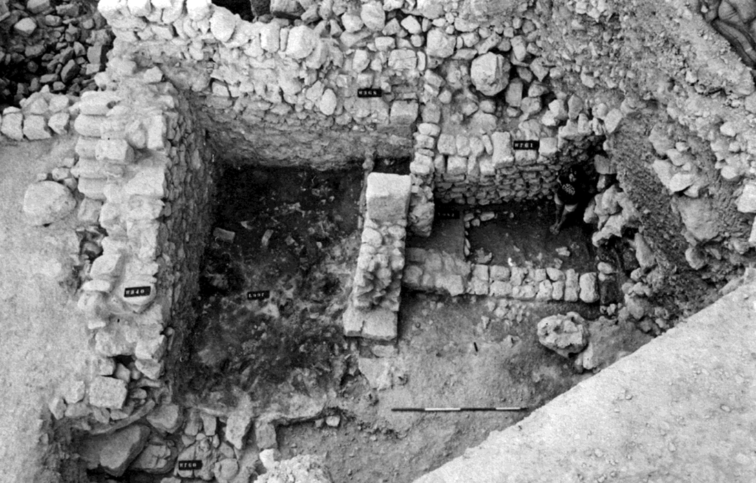 Fig. 7
Jerusalem: Area G on the south-eastern hill: “Burnt Room” House (Locus 997) and adjacent rooms on north, looking west
(after Shiloh 1984, pl. 32:2, 18)
Fiaccavento (2014)
Y. Shiloh distinguished two sub-phases of the total destruction of these houses: the first was a vast conflagration (10B) that burnt and led to the collapse of the upper storeys (wooden beams and ceilings along with wooden decoration and furniture), filling up the space of the lower floors; the second (10A) is the subsequent accumulation of debris, tumbling down from the upper terraces, that preserved the northern and western structures, and its contents. The same picture was already depicted by Kenyon’s excavation, where residential and commercial Buildings I-VII of Area A, partly built up over terracing substructures of 12th - 10th century BC, were recovered destroyed and filled up by carbonized layers179. Also in the southern part of the Temple Mount, the so-called Ophel, the administrative structures of Iron Age IIB-C, Buildings C and D, were retrieved destroyed in a fierce conflagration, with a large numbers of smashed jars an bowls and twelve pithoi plunged into a thick layer showing evidences of intense fire.180
The fall of Jerusalem put the end word to the Levantine world of the Iron Age. The generalized destructions and the absence of a ruling class, deported in Babylonia, led to a severe demographic and cultural crisis.
 Table 1
Sites (And Layers) In The Shephelah That Supplied Data For Radiocarbon Dating, Equated With The Gezer Tandy Excavation Strata
Finkelstein and Piasetzky (2024)
 Table 2
Transition between Periods, The Shephelah Model (Finkelstein and Piasetsky 2023) versus Gezer Model B (The One Preferred By Webster Et Al. 2023: Table 4)
Finkelstein and Piasetzky (2024)
 Table 3
Differences In The Construction Of The Two Gezer Models — The Authors’ And Ours
Finkelstein and Piasetzky (2024)
 Table 4
Transition Between Periods At Gezer (Rel Ative Chronology): Webster Et Al. 2023 And Our Own Gezer Model
Finkelstein and Piasetzky (2024)