Open this page in a new tab

Tiberias - Umayyad Mosque
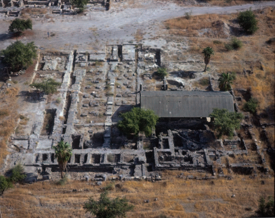
Ravani’s excavations Fig. 8

Aerial view of Ravani’s excavations, looking east. In the foreground are the cardo and shops; in the middle is the pillared building. The bathhouse (partly covered) is to the right. (Photo: courtesy of Sonia Haliday Photographs)

Note by JW: Cytryn-Silverman (2009) interprets the pillared building as the Umayyad Mosque of Tiberias

Cytryn-Silverman (2009)


Introduction
Introduction

Cytryn-Silverman (2009) examined previous excavations made in city center of Tiberias and argued that what was previously interpreted as a covered Byzantine market was in fact part of an Umayyad Mosque something Tiberias (Tabariyya in Arabic) would have had as it was the capital of Jund al-Urdunn (the military district of the Jordan) in the early Islamic period. Cytryn-Silverman (2009)'s argument was based on textual accounts by al-Maqdisi in 985 CE and Nasir i-Khusraw in 1047 CE along with architectural similarities with other Umayyad mosques such as the Great Mosque of Damascus, the Mosque of Khirbet al-Minya, and the mosque of Qasr al-Hayr al-Sharqi. Cytryn-Silverman (2009) mentions earthquakes in 749, 1033 and possibly 1068 CE but does not present any archaeoseismic evidence as the focus of the article was in identifying the pillared building as an Umayyad mosque.

History of Tiberias until the arrival of the Crusaders

The foundation date of Tiberias is not certain. Named after Tiberius (reigned 14–37 CE), it is believed to have been founded by Herod Antipas, son of Herod the Great, as his capital some-time between 18 and 20. In 39 Antipas’s nephew, Agrippa I, gained control over the city and ruled it up to his death in 44 CE. Until 61 CE it was ruled by the procurators, when its political status changed when it was annexed to the kingdom of Agrippa II, whose capital was at Banias. In about 100 CE it came under direct Roman rule. During Hadrian’s reign (117–138 CE) there commenced the erection of a temple in his honor in the middle of the city, which, however, was never finished.

In the third century, Tiberias flourished: not only was it granted the status of a Roman colony (under Elagabalus [reigned 218–222 CE]), but also it became the capital of the Jewish people, after the Sanhedrin, the Patriarchate, and the leader of the community all had moved there from Sepphoris. Rabbi Yohanan, head of the Sanhedrin, established the bet ha-midrash ha-gadol, where the Palestinian Talmud was mostly written. From the sixth century on, Yeshivat Eretz Israel, the supreme religious institution for the Jews in Palestine and the Diaspora, was active in Tiberias, at least until the tenth century (of note is the fact that the Aleppo Codex was compiled in Tiberias at this time), when it finally moved to Jerusalem. Even then, Tiberias continued to serve as a center for the Masoretes, who dealt with the correct vocalization of the Holy Scriptures, for Hebrew grammarians, as well as for poets and preachers.

The prominent Jewish character of Tiberias might have been the main reason the Christian community did not take off, at least until the fifth century.2 Yet, despite the slow penetration of Christianity into Tiberias, we know that by the mid-fifth century it is already a seat of a bishopric, as its bishop (John) is mentioned in the lists of the Council of Chalcedon (451 CE).3

Tabariyya, as it is named in Arabic, was conquered by Arab armies in 635 CE. According to al-Baladhuri (d. c. 892)4, the terms of surrender guaranteed a smooth and peaceful change of government. Eventually Tabariyya was chosen to be the capital of Jund al-Urdunn, ultimately to the detriment of Baysān/Scythopolis, capital of Palaestina Secunda. It is not clear,nevertheless, when exactly this shift of capitals took place.

Three major earthquakes affected Tiberias during the Early Islamic period: 749 CE, 1033 CE, and 1068 CE. The first certainly caused much destruction, as we learn from the excavations at Galei Kinneret,5 but the earthquake was followed by renovation, building, and expansion. The earthquake of 1033, until recently thought to have brought Tiberias to an end, was not as dramatic for Tiberias. The account of the Persian traveler Nasir-i Khusraw of 1047 CE makes no reference to a devastated city, quite the opposite:6
The city has a strong wall that, beginning at the borders of the lake, goes all round the town; but on the water side there is no wall. There are numerous buildings erected in the very water, for the bed of the lake in this part is rock; and they have built pleasure-houses that are supported on columns of marble, rising up out of the water. The lake is full of fish.
Nasir-i Khusraw goes on, describing the Friday Mosque in the middle of the town, as well as another one called Jasmine Mosque, on the western side of the city.

In addition to natural disasters, Islamic Tiberias was hit by invasions and sacking. In 906 CE the Ismaili Qarmatis, fighting against the Tulunids for the leadership of Syria, captured Tiberias, a major army base at the time. The sources tell that, following the resistance of its people, the city was plundered, women taken captive, and many people killed7. The eleventh century was even harder for Tiberians, as in general for the people of Palestine. Even before the earthquake of 1033 CE8, drought and unrest had struck the region. The Banu Jarrah Bedouin caused much instability. In August 1024 CE, their leader al-Hassan b. al-Mufarrij sacked Tiberias and killed its people mercilessly.9

Not withstanding the unrest, southern Syria under the Fatimids — and especially its two capitals, Ramla and Tiberias — witnessed a golden age. Much building and commercial, cultural, and religious activities took place. But toward the 1050s–1060s, the situation changed again, this time creating a political vacuum from which it was dfficult to recover. Jewish letters found in the Geniza are testimony to the stress under which the population of Syria lived.10 This situation, among others, made room for the Seljuq invasion of the 1070s, when Tiberias was made the Seljuq base against the Fatimids.11

In August 1098, the Fatimids managed to regain Jerusalem from the Seljuq Turks, putting an end to their rule over Palestine. Yet the Fatimids’ hold was short, and in July 1099 Palestine fell into the hands of the Crusaders. The old city center of Tiberias became a quarry for building material to the newly established Crusader fortfication to the north of the city.12
Footnotes

2 The Panarion of Epiphanius (fourth century) includes a passage that seems representative of the Jewish sovereignty in Tiberias, despite being under Christian rule. The passage refers to Count (Comes) Joseph from Tiberias, a Jew converted to Christianity and protégée of Constantine (reigned 306–337 CE). He planned to build a church at the site of the unfinished Hadrianeum, but the local Jews often disrupted his works. So he eventually built a small church at the site of the temple, left the city, and settled in Beth She’an. See The Panarion of Epiphanius of Salamis (trans. F. Williams; Nag Hammadi Studies 35; Leiden: Brill, 1987), book 1, sections 1–46, §30.12,1–12,9.

3. R. Price and M. Gaddis, trans., The Acts of the Council of Chalcedon (Translated Texts for Historians 45;Liverpool: Liverpool University Press, 2005), 1:360.

4. Ahmad ibn Yahyā ibn Jābir al-Balādhurī, Futūh al-buldān (Leiden: Brill, 1866), 115–16

5. License no. A-3607. Moshe Hartal, “Tiberias, Galei Kinneret,” HA-ESI 120 (2008)

6. Nāsir-i Khusraw, Safarnāma, ed., Yahyā al-Khashshāb (Beirut: Dār al-Kitāb al-Jadīd, 1983), 52.

7. Moshe Gil, A History of Palestine, 634–1099 (Cambridge: Cambridge University Press, 1997), §468.

8. A further earthquake, which took place in September 1015, is recorded by the sources, but apparently it was of little consequence, the main result being the collapse of the dome at the Dome of the Rock in Jerusalem. See ibid., §581. For the earthquake of 1033 and 1068, see ibid., §§595 and 602.

9. Ibid., §585.

10. Ibid., §596.

11. Ibid. §603.

12. On this fortfication, see Yosef Stepansky, “The Crusader Castle of Tiberias,” Crusades 3 (2004): 179–81.

Tiberias - Introduction Webpage

Maps, Aerial Views, Plans, and Photos

Maps

Normal Size

  • Fig. 1 Map of Tiberias from Cytryn-Silverman (2009)
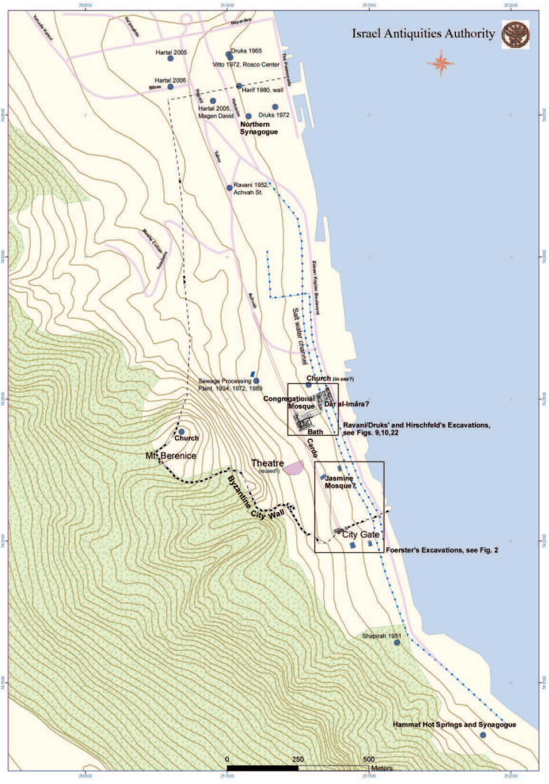
  • Fig. 2 Foerster’s excavation areas (A–D), 1973–74 from Cytryn-Silverman (2009)

Magnified

  • Fig. 1 Map of Tiberias from Cytryn-Silverman (2009)
  • Fig. 2 Foerster’s excavation areas (A–D), 1973–74 from Cytryn-Silverman (2009)

Aerial Views

Normal Size

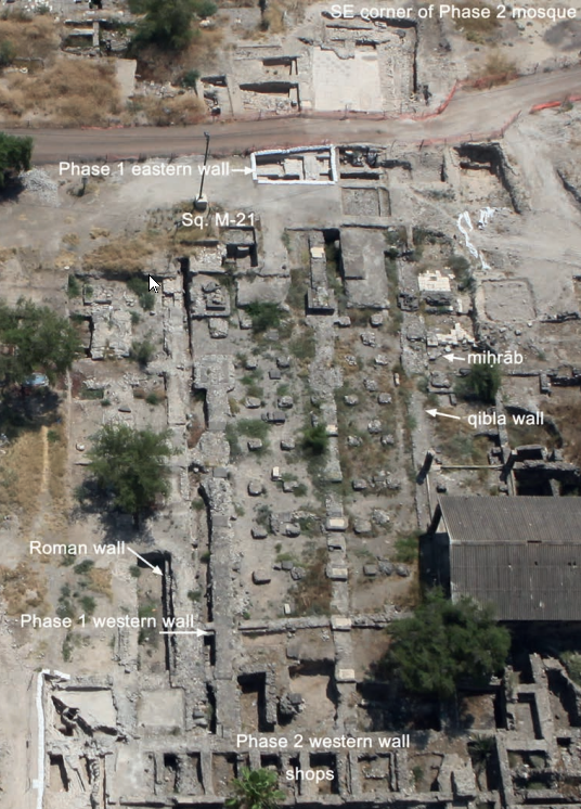
  • Fig. 1 Aerial View of Umayyad Mosque in Tiberias from Cytryn (2016)
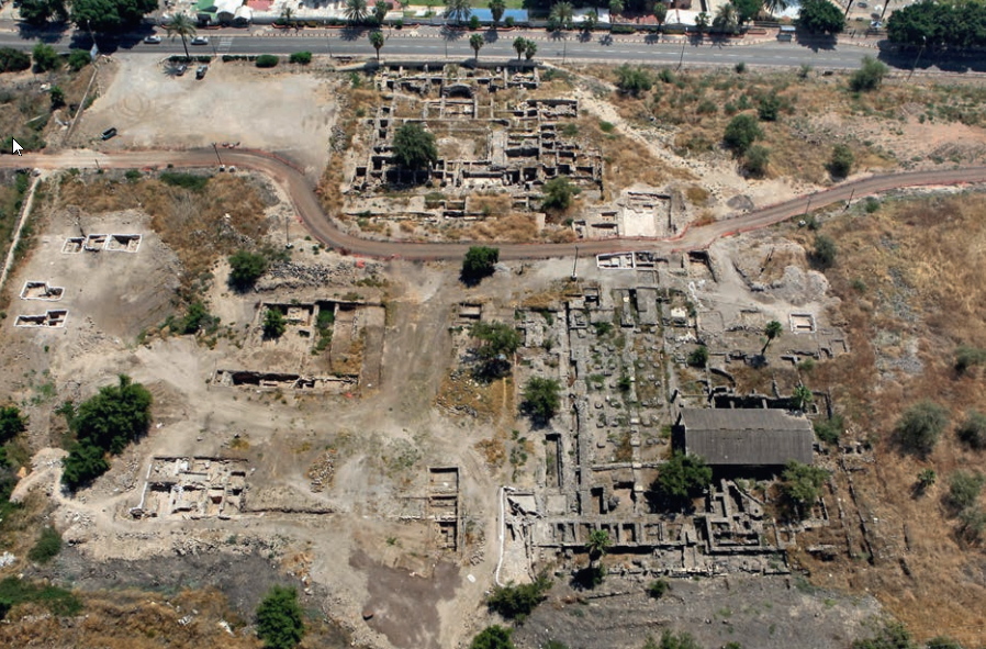
  • Fig. 3 Aerial View of the covered hall of the Umayyad Mosque in Tiberias from Cytryn (2016)
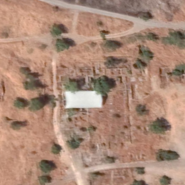
  • "Umayyad Mosque" of Tiberias in Google Earth
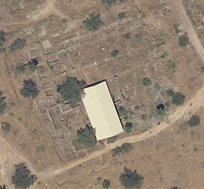
  • "Umayyad Mosque" of Tiberias on govmap.gov.il
Magnified

  • Fig. 1 Aerial View of Umayyad Mosque in Tiberias from Cytryn (2016)
  • Fig. 3 Aerial View of the covered hall of the Umayyad Mosque in Tiberias from Cytryn (2016)
  • "Umayyad Mosque" of Tiberias in Google Earth
  • "Umayyad Mosque" of Tiberias on govmap.gov.il

Plans

Normal Size

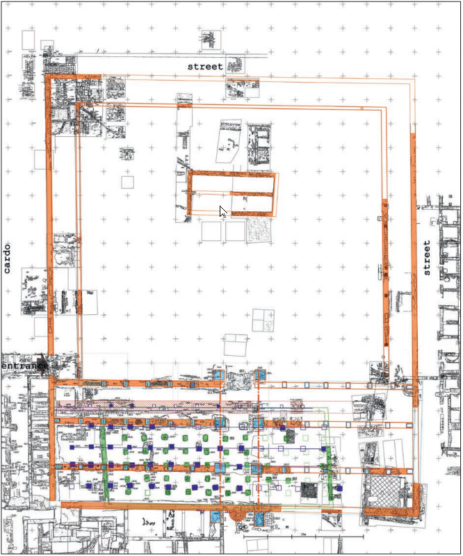
  • Fig. 2 Ground plan of excavations of the Umayyad Mosque in Tiberias from Cytryn (2016)
  • Fig. 3 Aerial View of the covered hall of the Umayyad Mosque in Tiberias from Cytryn (2016)

Magnified

  • Fig. 2 Ground plan of excavations of the Umayyad Mosque in Tiberias from Cytryn (2016)
  • Fig. 3 Aerial View of the covered hall of the Umayyad Mosque in Tiberias from Cytryn (2016)

Photos

Normal Size

  • Fig. L - Remains of Tiberias’ Early Islamic congregational mosque from Cytryn-Silverman (2015)
  • Fig. 8 - Remains of Tiberias’ Early Islamic congregational mosque (the pillared building) from Cytryn-Silverman (2009)
  • Fig. 4 Southeastern side of the Umayyad Mosque in Tiberias from Cytryn (2016)
  • Fig. 5 Western portion of the Umayyad Mosque in Tiberias from Cytryn (2016)
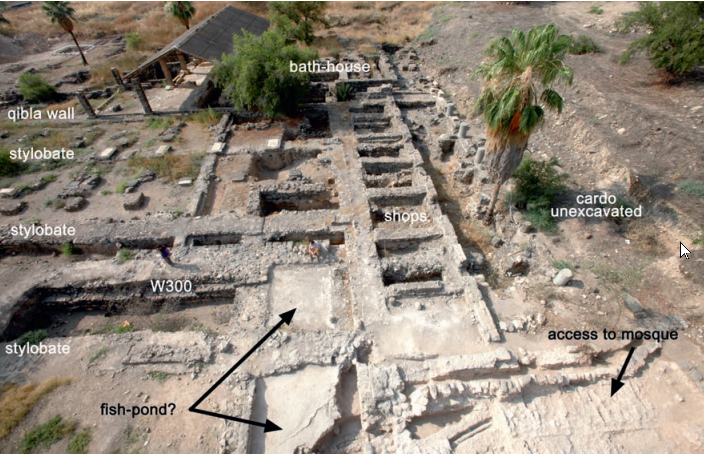
  • Fig. 6 Coarse foundation of the Phase 1 Umayyad Mosque in Tiberias from Cytryn (2016)
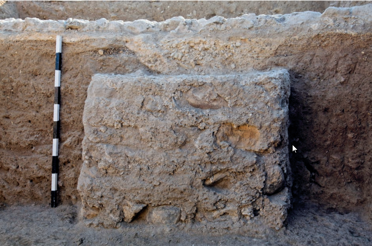
  • Fig. 7 Baulk showing floor levels of the Umayyad Mosque in Tiberias from Cytryn (2016)
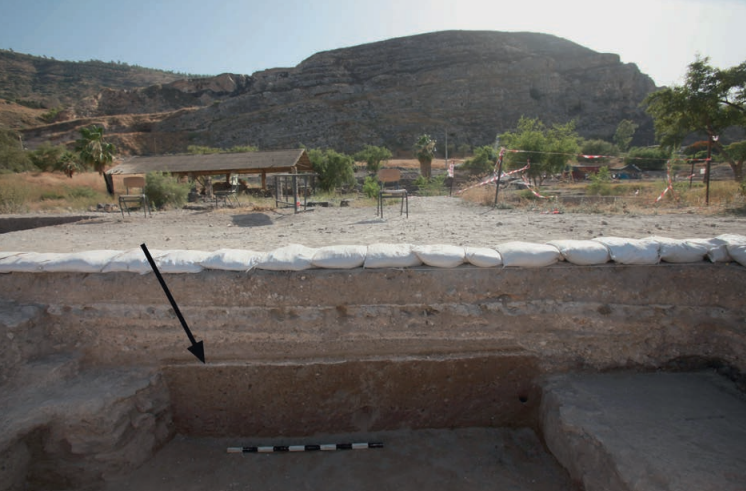
  • Fig. 8 Northernmost stylobate of the Umayyad Mosque in Tiberias from Cytryn (2016)
Magnified

  • Fig. L - Remains of Tiberias’ Early Islamic congregational mosque from Cytryn-Silverman (2015)
  • Fig. 8 - Remains of Tiberias’ Early Islamic congregational mosque (the pillared building) from Cytryn-Silverman (2009)
  • Fig. 4 Southeastern side of the Umayyad Mosque in Tiberias from Cytryn (2016)
  • Fig. 5 Western portion of the Umayyad Mosque in Tiberias from Cytryn (2016)
  • Fig. 6 Coarse foundation of the Phase 1 Umayyad Mosque in Tiberias from Cytryn (2016)
  • Fig. 7 Baulk showing floor levels of the Umayyad Mosque in Tiberias from Cytryn (2016)
  • Fig. 8 Northernmost stylobate of the Umayyad Mosque in Tiberias from Cytryn (2016)

Archaeoseismic Chronology
Phasing

Phases of the Umayyad Mosque at Tiberias- Cytryn (2016)

Phase Period Date Description
I Early Mosque 7th century CE First congregational mosque of Tiberias, probably established shortly after the Arab conquest of 635 CE. The building consisted of a hypostyle hall approximately 21 × 48 m in size. Construction reused Roman-period remains and employed simple conglomerate column foundations. The associated courtyard was smaller than in later phases.
II Monumental Umayyad Mosque 8th century CE The mosque was expanded into a large monumental complex measuring about 78 × 90 m. Its plan followed major Umayyad models such as Damascus, with a transept, courtyard, porticoes, and projecting mihrab. Deep stylobate foundations, mosaics, frescoes, and a large cistern reflect substantial investment.
III Post-Seismic Reconstruction After 749 CE Constructed after the earthquake of 749 CE. Builders rapidly restored the mosque using a simpler construction technique with rustic conglomerate foundations and reused columns. The rebuilding prioritized functionality over the monumentality of Phase II.
IV Late Abbasid–Fatimid Mosque 10th–11th centuries CE The mosque was restored to a monumental three-aisled plan resembling Phase II. A billon coin of al-Mustansir Billah dates the latest occupation. Structural cracking and collapse are associated with the earthquake of 1068 CE. The building was subsequently abandoned.
V Post-Mosque Occupation 12th–13th centuries CE Following abandonment, the former mosque area was reused for sugar-related activities. Sugar bowls, molasses jars, ovens, and associated industrial debris indicate integration into the regional sugar economy during the Crusader period. The site functioned as part of a broader agricultural and manufacturing landscape.

New Columns in the Aisle Earthquake (?) - mid-8th century CE

Discussion

Discussion

References
Cytryn (2016)

Introduction

During the past seven years1, three important Umayyad sites on the western shore of the Sea of Galilee have been the focus of archaeological excavations: Tiberias, the provincial capital of Jund al-Urdunn, and the two palatial complexes of Khirbat al-Minya, ca. 13 km north of Tiberias, and Khirbat Kerak/Sinnabra, ca. 9 km south of the city. This article deals with the first two of these sites, where excavations on behalf of the Hebrew University of Jerusalem follow a series of earlier projects (in the case of Tiberias, the excavations are being conducted concurrently with works by the Israel Antiquities Authority). Excavations at Khirbat Kerak, focusing on the Islamic layers, were conducted by Tel Aviv University in 20102 following the reappraisal of this site by Donald Whitcomb (University of Chicago) as the Umayyad qasr of Sinnabra3.

The early city centre of Tiberias has been explored by the author since 20094, following earlier work of the 1950s (Bezalel Ravani), 1960s (Adam Druks) and 2004–2006 (Yizhar Hirschfeld)5. Excavations at Khirbat al-Minya were co-directed by Myriam Rosen-Ayalon, Giora Solar (architect/conservator), and by the author in 2005 and 20066.

Despite the sites’ functional differences— Tiberias representing an urban centre of regional importance deriving from its role as the capital of Jund al-Urdunn, while al-Minya was a palatial manor house catering to the Umayyad elite—both have yet much in common, of which some will be discussed in this article.
Footnotes

1 This article was submitted in 2011. Since then work has continued in Tiberias and further developments at the mosque area and surroundings will be reported in a separate article.

2 Greenberg – Tal – Da’adli (forthcoming).

3 Whitcomb 2002.

4 Between 2009 and 2011, the renewed excavations at Tiberias, under the auspices of the Hebrew University of Jerusalem, have been generously funded by the Van Berchem Foundation, Geneva, the Yizhar Hirschfeld Memorial Fund, Jerusalem (with partial matching from the Amiran Fund of the Institute of Archaeology of the Hebrew University of Jerusalem), the Israel Science Foundation (Centre of Excellence, project no. 1679/09, The Formation of Islamic Society in Palestine, 600–1500), and the Fritz Thyssen Foundation, Cologne. For some preliminary results, see Cytryn-Silverman 2012.

5 For full references to these excavations, see Cytryn-Silverman 2009, 44–48.

6 Rosen-Ayalon – Cytryn-Silverman – Solar 2005.

Tiberias

Since spring 2009, remains of the congregational mosque have been exposed by the ongoing New Tiberias Excavation Project, adding to the large portion of the hall uncovered in the 1950s. This covered hall was originally thought to have been the Byzantine marketplace of Tiberias’ ancient city centre, and was reinterpreted by the author as the city’s main mosque thanks to its general layout, which corresponds to that of the Great Mosque of Damascus and many other Umayyad mosques of Bilad al-Sham.

The covered hall is 78 m wide and 26 m long (fig. 2: in orange). The full length of the mosque, including the courtyard and portico, is 90 m. Thus, its total area is only very slightly smaller than that of the White Mosque of Ramla, the capital of Jund Filastın (84 by 93 m, including post-Umayyad alterations). Today we are able to trace at least four phases of Tiberias’ Friday Mosque.

Phase 1 (fig. 2: in green) seems to be datable to the 7th century AD, making it the first mosque erected in Tiberias. It was probably constructed soon after the city’s conquest in 635 AD by Shurahbıl ibn Hasana. Al-Bala¯ dhurı (d. ca. 892 AD) mentions that after Tiberias had surrendered to the Arabs, ibn Hasana chose the location for the construction of a mosque7.

Our reconstruction of this mosque, still a work in progress, follows the many coarse column foundations excavated between and beneath the stylobates of the later monumental mosque (Phase 2) of the 8th century AD (fig. 3). It is also based on the finding of a northwest-southeast wall in squares N-20 (W972) and N-21 (W971) (figs. 3–4), which runs parallel to a second wall on the west (W105) found at a distance of ca. 9.5 m of the shops of the cardo by Ravani in the 1950s (fig. 5; cf. fig. 3). The reconstruction also assumes that the builders of the first mosque re-used remains of a massive wall (W300; figs. 2 [in red], 3, 5) of the Roman period (2nd–3rd centuries AD), excavated by Ravani and re-examined by Hirschfeld in 2004. Accordingly, the structure is a hypostyle hall measuring ca. 21 m in length by 48 m in width.

The foundations are conglomerates of fieldstones in a hard greyish mortar (fig. 6) thrown into pits which were dug in an artificial fill that leveled the area above the remains of the Roman period8. The foundations vary in depth, implying that the columns above them were of different heights.

A shallow plastered pool, interpreted by Hirschfeld and Galor9 as a ‘fish-pond’ on the basis of the cooking pots inserted into its low walls that could have served for breeding fish, abuts the back of a shop and underlies the Phase 2 mosque (fig. 5). One of the pots (no longer extant) was of a type datable to the 7th–8th centuries AD10, hinting that this pool was in use concurrently with the Phase 1 mosque. The floor related to this phase could not be clearly discerned, though during our fifth season in 2011, we found some fragments of a plaster layer (#M2.369, M2.373 and #M2.374) in square N-21 (Area M2), which rose onto the eastern wall of the mosque and was also detected in the baulks (fig. 7).

However, the level of this floor is very low in relation to some of the column foundations. Moreover, it is much lower than a small trace of small pebbles found in the section of square M-21 (fig. 6), which may well relate to this phase (the use of small pebbles taken from the Sea of Galilee for paving is well attested in the courtyard of the mosque throughout its various phases)11. The extent of the courtyard facing this first mosque is not clear, though it was certainly smaller than that of Phase 2. In fact, structures apparently related to the late 6th–early 7th centuries AD were found underlying the courtyard of the Phase 2 mosque north of its cistern, thus revealing that this area was beyond the limits of the mosque in Phase 1.

In Phase 2 (fig. 2: in orange), the mosque expanded not only northwards but also to the west and east. On the west, the mosque now abutted the shops of the cardo, cutting and burying the ‘fish-pond’ mentioned above (fig. 5). On the east, it expanded over pre- or early Islamic constructions, whose layout is not totally clear, due to a modern path that crosses the area, which prevents us from fully exposing the structures (fig. 4). Still, east of this path, we have been able to expose a hall underneath the south-eastern edge of the monumental mosque of Phase 2, cut by both the mosque’s southern stylobate and its southern (qibla) wall. This hall consisted of a rectangular room (10 × 8 m) crossed east-west by a central arch supported by two engaged pillars. The room’s floor was entirely covered by a geometric mosaic made from large tesserae (ca. 2 × 1.7–2 cm). Some of the motifs are unique, and the composition and style place the workmanship in the 7th century AD12. The walls were covered with frescoes, some of which were found in situ in our fourth season in 2010. The entrance is located in the north-eastern corner, thereby ruling out a physical connection to the Phase 1 mosque. Nevertheless, the proximity of the two and the uniqueness of the mosaic suggest a special role, which remains to be identified for this building.

The new Phase 2 mosque at Tiberias replaced the earlier simple hypostyle building with a monumental one whose ground plan and decoration imparted a virtually Damascene atmosphere to the city. To achieve such splendour, the architects preferred deep stylobates to the former rustic conglomerates as foundations for pillars. These stylobates were sunk quite deep into the ground, a building technique not unlike that used for the erection of the Umayyad buildings in Jerusalem—deep trenches filled with a very hard greyish mortar mixed with pebbles13. Re-used late Roman Jewish tomb doors were laid over the northern and southern stylobates as bases for the pillars, while limestone slabs were used as bases for the southernmost one (figs. 3, 8)14.

This new mosque followed the prototype of Damascus: three aisles parallel to the qibla wall, a tall, wide transept crossing the building, and a portico surrounding three sides of the courtyard. Like various other Umayyad mosques, Tiberias’ Phase 2 has a central rounded niche (the mihra¯b) that protrudes from the wall. In addition, it had at least one underground cistern (ca. 7.5 × 17 m), which was found within the limits of the courtyard.

The Umayyad mosque in Tiberias revealed to us that some of the central mosques of Bilad al-Sham followed a hierarchical standard, Damascus (and perhaps also Jerusalem)15 being the largest and most monumental, followed by the capitals of the ajnad (Tiberias and Ramla) and by the regional centres, such as Jarash (38.9 by 45 m)16. The overall size of the mosque at Jarash, for example, is a quarter of that of Tiberias. The mosque of the large enclosure at Qasr al-Hayr al-Sharqı (38 by 48.5 m), erected during Hisham b. ‘Abd al-Malik’s reign according to an inscription found in a secondary context on one of the pillars at the mosque17, is slightly longer than that of Jarash, but in general conforms to similar proportions. In addition, the mosque at Qasr al-Hayr al-Sharqı shares its intercolumniation rate with Tiberias, raising the possibility they were built around the same time18. Finally, even the mosque at Khirbat al-Minya (ca. 15 by 22 m) seems to conform to this proposed hierarchy, its length being a fourth of that of Tiberias’ and its breadth a fifth, resulting in a total area one twentieth of that of the congregational mosque in Tiberias19.

Phase 3 of Tiberias’ mosque (fig. 2: in dark blue) seems to have followed the earthquake of 749 AD20. Its builders were apparently eager to erect the mosque as soon as possible and hence returned to the construction technique of the first mosque—a new series of rustic conglomerate foundations which bore columns of various heights laid right in the middle of the central and southern aisles, in addition to those built against the stylobates.

In Phase 4 of the building (fig. 2: in turquoise), apparently towards the 10th century if to follow al-Muqaddası’s description21, the monumentality of Tiberias’ Friday Mosque appears to have been re-established as it returned to the three-aisled plan of Phase 2. Its latest use has been dated by a billon of Caliph al-Mustansir Billah found in square M-21 in the disturbed fill under the latest floor. The plaster floor, which was laid over a layer of cobblestones, displayed at this square a clear crack opened by an earthquake (fig. 3)22. This seems to be the one which caused the mosque to collapse in 1068, burying under the collapsed rubble and broken roof-tiles many fragments of brass chains and of glass mosque-lamps that were once suspended from the ceiling23.

It is not clear what happened to the mosque after the earthquake of 1068. The troubled 11th century24 apparently left Tiberias without a stable infrastructure that could initiate a rebuilding of the mosque, as had happened after 749 AD when the city served as the provincial capital. We do know that settlement in this area of Tiberias, below Mount Berenice and near the city centre, continued in some form. In 1998, excavations by Hirschfeld and Gutfeld at the sewage treatment plant25 uncovered three pithoi filled with brass objects, most from the 11th century, as well as a hoard of 85 coins, 59 of which were anonymous folles with the effigy of Christ on the obverse and the inscription “Jesus Christ, King of Kings” on the reverse, the latest dated to the reign of Michael VII Ducas (Parapinakes), 1071–107826.

However, the decision to erect the Crusader fortifications north of the old city centre, at the location of the modern city, provides further evidence for the abandonment of the mosque and its surroundings, which became a quarry for building material.

After a while, though, the grounds of the mosque became the location of an altogether different activity: judging by the many sugar bowls, molasses jars and amphoras found in a building complex erected in the north-western corner of the former mosque (Area M1-nw), this area seems to have catered in some way to the sugar industry during the 12th–13th centuries (fig. 9). Although no presses, mills, water basins or ovens have yet been found in a secure context in Area M1, remains of a round oven built of stone and full of ash, sugar bowls and molasses were excavated to the south of the apse of the Byzantine building by Hirschfeld in 1993, near the modern road and not far from our excavations27.

A Crusader document from 1182 brings life to our finds: it deals with a demand for sugar produced by the Hospitallers in Tiberias for the general needs of their Hospital in Jerusalem28.
Footnotes

7 De Goeje 1866, 115–116.

8 It is still not clear how this area functioned in the course of the Byzantine period. Byzantine remains have been found all over the area: in the bathhouse to the south, best attested by its mosaics; in the monumental apsidal building immediately to the east, excavated by Hirschfeld; and to the north, where the monumental church is located (fig. 1).

In the mosque area the ‘Byzantine’ finds are mostly related to the transitional period of the late 6th–7th centuries AD, with the exception of the many 4th–6th centuries AD minimas collected mainly from the artificial fill of the mosque (these minimas are being studied by G. Bijovsky of the Israel Antiquities Authority). In our partial excavation of one of the shops abutting the mosque from the west (locus M1.134, square G/H-24, Area M west), finds of the early Roman period abound (large amounts of pottery sherds, many possibly restorable pieces of fresco, tesserae, etc.) immediately under those of the 8th–9th centuries AD.

9 Hirschfeld – Galor 2007, 215, where it is dated to the 3rd century AD.

10 Stacey 2004, 123 fig. 5.32.4. Unfortunately, these cooking pots have since been removed by looters, preventing proper documentation apart from the field photographs.

11 The use of pebbles in the mosque in Tiberias reminds us of al-Muqaddası¯’s words: “The mosque is large and fine, and stands in the marketplace; its floor is laid in pebbles, and the building rests on pillars of joined stone”, de Goeje 1906, 161; Collins 1994, 148.

12 Miller 2011, ii, 115–119 (F1: I–VI).

13 Ben-Dov 1973. A study of the construction techniques in use at the mosque of Tiberias is under way by the author. Mortars are being studied by Haifa MA student Mr. Meidad Schor, under the supervision of Dr. R. Lyn, Prof. A. Tsatskin and the author.

14 Despite this assessment, previously presented in Cytryn-Silverman 2009, 54, there is still a possibility that these spolia were inserted as bases for pillars in the fourth and latest stage of the mosque, when the builders returned it to the layout of Phase 2 (fig. 2). This is hinted at by what seems to be the repairing of the stylobate in some of the areas. The tomb doors have been studied by Mr. P. Betzer of the Institute of Archaeology of the Hebrew University of Jerusalem as part of his MA thesis, “The Necropolis of Tiberias during the Roman and Byzantine Periods”, 2013.

15 On the possible inspiration of Damascus’ plan in Jerusalem’s Umayyad mosque, in its turn influenced by remains of the Herodian stoa, see Grafman – Rosen-Ayalon 1999.

16 Cytryn-Silverman 2009, 49–53.

17 The inscription, seen on one of the mosque’s pillars by J.-B. L. J. Rousseau at the beginning of the 19th century and no longer extant, was in secondary context, probably brought there during a reconstruction of the mosque. In their “City in the Desert”, O. Grabar, R. Holod, J. Knustad and W. Trousdale (Grabar et al. 1978, i: 191) support Ch. Clermont-Ganneau’s reading of the second word in the fourth line as madı¯na, and not as ma¯dhana as suggested by R. Dussaud. The former reading suggests that the inscription may originally have been set on the outer walls, or in one of the gates. In any case, since the excavators believe the reconstruction plan followed that of the original (Grabar et al. 1978, i: 46), the dating is still relevant: “Has ordered the construction (lit. making) of this madı¯nah the servant of God Hishâm, Commander of the Faithful, and this was done by the people of Homs under the direction of Sulaymân ibn ʿUbayd. In the year [one hundred and] ten A.H. (728–729 AD)” (Grabar et al. 1978, 191).

18 Cytryn-Silverman 2009, fig. 15b.

19 For an earlier assessment of the relationship between the mosques at Tiberias and Minya, see Cytryn-Silverman 2009, 49 fig. 14.

20 Tsafrir – Foerster 1992, 231–235.

21 See above, footnote 11, where the passage refers to pillars of joined stones but no columns.

22 Cytryn-Silverman 2012, figs. 6–7.

23 Some chain fragments were found during our work (for one such example see Cytryn-Silverman 2012, fig. 5). For the long portions of chains found by Ravani and by Hirschfeld, see Lester – Hirschfeld 2006, 145–158.

24 Gil 1997, 377–418 § 566–609.

25 Hirschfeld – Gutfeld 2008.

26 Bijovsky 2008.

27 Hirschfeld 1997, 40, where these finds are dated to the 13th–15th centuries, though they are most probably also of the 12th–13th centuries, as in our excavations.

28 Stern 1999, 31, quoting Amar 2000, 308–309.

Khirbat al-Minya

In the case of Khirbat al-Minya, the second Umayyad site under discussion in this article, I shall start from the level that was buried under a deep fill and supplanted by constructions of the Mamluk or Ottoman periods29.

At some time in the late 13th century or the 14th century, a devastating fire put an end to the thriving sugar production that had been established during the Crusader period (12th century) within the premises of the old Umayyad palace. The evidence for sugar production was already apparent before our excavations, as pointed out by Edna Stern in her MA thesis on sugar production in Palestine30. There are remains of a press in the north-eastern room of the palace, another press was outside near the entrance to the mosque, and a large brick oven stood in the south-eastern corner of the courtyard near the mosque, while a water channel connected it to an opening at the bottom of the building’s southern wall. For many years, fragments of sugar bowls and molasses jars remained unidentified among the finds of the German expeditions31 and the Joint Expedition of 195932, and were put in context only when studies of sugar production began to emerge33.

During the Hebrew University of Jerusalem excavations in 2005 and 2006, our work focused mainly on the western side of the palace, apart from conservation work and re-exposure of some features excavated in the 1930s.

The conservation work was aimed mainly at preserving the mosaics and reinforcing some walls and the fragmentary dome of the western wing, but also at clearing the dense thorny vegetation that covered the northern wing and the intrusive trees threatening the exposed structures in the east. The three towers in the west were also exposed. This clearance work also allowed architect and conservator G. Solar to re-examine the plan that he prepared for the Getty Conservation Institute (2001) and suggest that the original plan of the palace was composed of six (or perhaps seven?) domestic units (fig. 11) in addition to the basilical hall, the mosque, and the room between them. This assessment takes into consideration not only the finds of our excavations but also the fact that the two niche-like spaces facing the mosque were originally a pair of rooms belonging to a bayt immediately to the north. The change in plan may have taken place following the insertion of the ramp leading to the roof (or to an upper unit over the eastern wing of the palace, as suggested by Markus Ritter34), as it seems that the walls of these rooms, together with an additional wall reinforcing the outer wall, served as support35.

In the west, two rooms partially exposed by the Joint Expedition in 1959 (fig. 12) were excavated down to their Umayyad phase. We started at the level where the Joint Expedition stopped, i.e. at the massive collapse of the barrel vault that covered Room B (fig. 13)36. The Joint Expedition had penetrated this collapse through a few small probes (loci 222, 228 and 229) that confirmed the presence of the original Umayyad mosaics, the remains of which were totally uncovered during our work (fig. 14).

This elongated room, using the space of what were formerly two small units of one of the Umayyad buyu¯t, with two sealed doors on the north and a later opening broken through on the south, contained several installations: two ovens dug into the ground and lined with lime and a basalt sarcophagus used as a water basin (fig. 15).

Once we started lifting the collapsed vault, we found that its inner lime coating covered parts of a no longer articulated skeleton of an equid. The animal lay on an ashy surface, apparently resulting from a fire that broke out at the complex (fig. 16).

The ovens and surrounding fills were found filled with fragments of sugar bowls (fig. 17) and molasses jars, which may thus have been out of use by the time of the building’s collapse.

After digging down to the original Umayyad level, we exposed the remains of the partition wall that once separated the two rooms (W4001; fig. 14). The mosaic floor of the western unit was found almost complete, apart from an area where the loose tesserae exposed the make-up of pebbles. In the east, the mosaic was destroyed when the ovens of the medieval period were dug through it.

A similar sequence was found in Room A in 2006 (fig. 18). This elongated room was apparently used by a blacksmith, who was probably in charge of producing and repairing the factory’s metal equipment. Metal slags, a lead ingot, fragments of metal vessels (fig. 19) and remains of the furnace were found over deposits that covered the Umayyad level. Unfortunately, on this side the damage to the original mosaic was much more massive than in Room B and only a few rows of the mosaic’s margin had survived (fig. 20).

By digging Room B to the level of the Umayyad mosaic, we were able not only to reveal two further examples of intricate geometric compositions, but also to uncover some pottery finds relating to the latest use of the palace as a manor house for the surrounding agricultural lands. Although the ‘Buff Ware’ sherds, lamps, and glazed fragments solely allow for a rough dating between the 9th and 11th centuries, we learn from the literary sources that the building was certainly still active in the 10th century. Abu ʿAlı al-Husayn b. Ahmad b. Rustum al-Madharaı, responsible for the taxes (kharaj) in Egypt on behalf of Caliph al-Muqtadir (from 919 AD onwards) had a dayʿa (country estate) named Munyat Hisham near Tiberias, most probably Khirbat al-Minya37.

Recent OSL analysis of a burnt layer in the courtyard area38 points to an even later date—the 11th century—for the abandonment of the site prior to its transformation into a sugar manufacturing plant.
Footnotes

29 There are few data on this building level (see below, footnote 33 and Mader 1933, Abb. XV). It should be noted that according to the Ottoman Defter (tax register) of 1005/1596–1597, Minya (recorded as Mına) was a village (qariya), then part of liwa’ Safad and of Nahiya Jıra. It numbered 110 heads of families and two bachelors (all Muslims), producing wheat, barley and vegetables/fruit, and owning beehives, water buffaloes and 60 water mills, with revenues endowed to the Madrasa Zahiriya in Jerusalem (Hütteroth – Abdulfattah 1977, 176 P24). Nevertheless, the income of the village was in fact endowed to Madrasa al-Taziya in Bab al-Silsila Street, as already pointed out in Burgoyne 1987, 411 n. 19. The waqfiyya of this Mamluk madrasa, established by Amır Sayf al-Dın Taz (d. 762/1361), one of Sultan al-Nasir Muhammad b. Qalawun’s mamluks and a prominent amır under the subsequent rulers, establishes as waqf the entire income of the village of Minya in Safad district which one assumes being the site under discussion, the entire income of a shop together with the baker’s oven in the said village, and also that of its mill (Burgoyne 1987, 401; from Defter no. 602, dated 990/1582, not yet examined by the author). This means that the village was an active source of income during the mid-14th century, continuing into at least the 16th century, if not later. This implies that the building remains comprising the upper layer at Khirbat al-Minya—assuming that they were an integral part of the village with a similar name—could also be representative of the Mamluk period, an issue that will be further pursued in future archaeological interventions.

30 Stern 1999, 84–86.

31 Mentioned in Bloch 2006, 53. See also in this volume pp. 151–152.

32 Grabar et al. 1960, 238–239, pl. 30, 15–19.

33 Among the many relevant publications, see Wartburg 1983; Galloway 1989; Jones et al. 2000, 523–534; Photos-Jones et al. 2002, 591–614; and more recently Peled 2009. See also the short survey, Strange-Burke 2004, for the main readings on the subject.

34 Personal communication, August 2011.

35 I would like to thank the conservator A. Hillman of the Israel Antiquities Authority for pointing out this arrangement.

36 The Joint Expedition concentrated on the western wing of the palace (Salles A–C), where they started by clearing remains of the latest settlement. In Room C they identified this level as belonging to any time from the 16th century onwards (Grabar et al. 1960, 230). In Room B the excavations penetrated the deposits under these late buildings, uncovering a collapsed vault.

37 Gil 1997, 137 § 235.

38 Erez Hassul, MA student of the Hebrew University of Jerusalem, Institute of Earth Sciences, is researching the seismology of the region of Minya. Amongst others, he presented his OSL results at an international conference at Ein Boqeq in 2014 (“The Contribution of Unique Destruction Layers to Archeoseismic Studies – Khirbet al-Minya as a Case Study”). Hassul’s results are in line with our conclusions regarding the end of Phase 4 of the mosque in Tiberias, dated by al-Mustansir’s billon (see above). It is worth mentioning that a skeleton of a middle-aged man who was caught by this sudden fire was exposed in the section of the courtyard of Minya in 2005. I would like to thank the late anthropologist Mario Chech, curator emeritus at the Musée de l’Homme in Paris, for examining the remains.

Conclusion

The history of Tiberias and Minya is clearly interconnected, as the latter was part of Tiberias’ hinterland during the early Islamic period, and an important sugar production centre during the Middle Ages. In fact, sugar production in southern Bilad al-Sham may have started even before the Crusader period, as finds at Kabri in the western Galilee39, and apparently also from Tiberias40, seem to imply. This is also suggested by the famous passage in al-Muqaddası’s geographical treatise41:

“It is said of the people of Tiberias that for two months they dance, for two more months they glut; for two months they flail about, and for two more months they go naked; for two months they pipe, and for two more months they wallow. The explanation of this is that they dance from the number of fleas, then glut themselves with the lotus fruit; they slap about the hornets with fly-swatters, to drive them from their meat and fruits; then they go naked from the intense heat; they suck the sugarcane; and then they must wade through their muddy streets (…).”

This humorous description of the people of Tiberias from 985 AD informs us that sugarcane was one of the agricultural products of the region during the Ikhshıdid–early Fatimid periods. Could it have been grown at the early Islamic estate at Minya? As sugarcane and sugar production seem to have been introduced to Greater Syria during the Umayyad period, most possibly by settlers from Persia, this possibility should not be ruled out42. We hope that future multidisciplinary work at the site and in its surrounding landscape will grant an assessment of this possibility.
Footnotes

39 Smithline 2004, 5*.

40 See Stacey 2004, 99 fig. 5.14.12 for a probable sugar mold dated to the early 11th century, though R. Evyasaf, of the Department of Landscape Architecture, Technion – Israel Institute of Technology, has suggested (personal communication) the use of similarly perforated vessels as flower pots, a possibility that should be further pursued.

41 Al-Muqaddasī 1906, 148.

42 Amar 2000, 303.

Cytryn-Silverman (2015)

Archaeological Finds

The Early Islamic Period

Early Islamic layers have been found in almost every excavation undertaken in Tiberias and its immediate surroundings since the first archaeological works in the city.61 Following are the main sites. In 1934, remains of dwellings dating from the Byzantine through the Fatimid periods were uncovered at the runoff channel at Wadi Ghazal.62 Between November 1971 and March 1972, Fanny Vito uncovered remains of stone paving at the Rosco Commercial Center near the Caesar Hotel, hinting at the stretching of the city northward during the Early Islamic period, beyond the Byzantine perimeter.63 Excavations at this area during 2005 and 2006 by Hartal clarified that this area was settled only after the 749 CE earthquake, which apparently destroyed part of the city. Furthermore, excavations at the parking lot at the Plaza Hotel, to the south of Harif's dig at the Jordan River Hotel (see above), exposed a segment of a wall which Hartal identified as that of the northern perimeter of the Umayyad city.64 In the south, Foerster's excavations pointed to an expansion beyond the city wall only in the mid-ninth century,65 though recent excavations by Hartal, Amos, and Hillman south of the Roman gate suggest that the expansion southward started as early as the Umayyad period (661–750 CE).66 At this time, the Roman vault over the wadi channel was still in use, as was the cardo street level. An inscription in Kufic Arabic, reading liSulayman, was hammered onto one of the paving stones facing a shop.67 Following the earthquake of 749 CE, when the Roman vault/bridge seems to have collapsed, a new construction took place, though because of the accumulation in the wadi channel, it had to be higher, creating a gap of 1 m between the new bridge level and the gate. Arches to the east of the bridge attest to a probable plaza, while the presence of pillars made of ashlar at the foot of the waterfall to the west hint at another bridge.68 At this stage, buildings were erected to the south of the channel, and they seem to have continued well into the eleventh century. Sometime during the tenth century, the passage at the gate was narrowed and wooden doors introduced. The finding of grenade-shaped vessels, together with an iron ax and early-ninth-century coins at the eastern tower, also confirm that the fortification was no longer of relevance.69

In addition to the many domestic buildings exposed in salvage excavations—including impressive neighborhoods at the slope of Mount Berenice (over the remains of the theater, for example),70 as well as at the Sewage Treatment Plant,71 to the south of the bathhouse,72 and at the northern section of the city73—one should also list the expansion of the bathhouse excavated by Ravani, the raising of the cardo level (see above), as well as the creation of a new north–south street with shops west of the apsidal building (see above). In fact, following the project excavations, it seems that this new street was connected to two others running east–west (a narrow street to the immediate south of the bathhouse exposed by Ravani is little known and not clear in the plans), thus circumventing, together with the cardo, a large insula containing the bathhouse and the main building of Tiberias during the Early Islamic period: the Friday Mosque.74

The mosque (see the Mosque Plan in the Photo Gallery, G-2), previously interpreted as a Byzantine market, consists of a large rectangle, 78 m wide by 90 m long. It is composed of a three-aisled covered hall (78 × 26 m) (fig. L) supported by pillars built atop reused Jewish tomb doors, a protruding prayer niche (mihrab), and a large courtyard enclosed by a portico. In the course of nine seasons (2009–2014), the main features of this mosque were exposed, while those already excavated by Ravani in the 1950s were put in context: long sections of the lower courses and foundations of the enclosure wall have been revealed; the four corners of the mosque have been exposed, that in the northwest standing out for the use of a twisted column of the second–third century as the "cornerstone" (fig. M), that on the southeast cutting a unique geometrical mosaic of the Late Byzantine–Early Islamic period (fig. N). Portions of the portico have also been exposed, including a column still in situ and column bases still in situ. A monumental entrance by steps from the cardo, right to the north of the covered hall (fig. E), seems to have been the main way of access during the Abbasid period. A further entrance seems to have been located on the eastern end of the covered hall, facing a complex of toilets excavated by Hirschfeld. So far no clear entrance has been detected on the northern wall. An underground cistern was found in the middle of the courtyard, and perhaps a square structure at the northeastern corner of the mosque might be a minaret of the Abbasid period.

On the basis of architectural comparisons with mosques of the region, it is possible to attribute the monumental mosque of Tiberias to the Umayyad period, perhaps even to the reign of Hisham b. 'Abd al-Malik (724–743 CE) following the close similarities to his mosque in Qasr al-Hayr al-Sharqi in Syria. Prior to this mosque, a simple hypostyle structure was erected at this site (see area marked in green on the Mosque Plan in the Photo Gallery, G-2), reusing the remaining Roman wall (see above). It was of a modest size, ca. 48 × 21 m, 7 by 11 aisles, separated by columns in secondary use, erected over rustic round foundations, cast into a deep fill, a technique introduced into Palestine after the Muslim conquest.

The covered hall of the Umayyad mosque was refurbished at some stage by the introduction of a row of columns in the middle of the aisles (see the area marked in dark blue on the Mosque Plan in the Photo Gallery, G-2). This probably took place following the earthquake of 749, and aimed at giving extra support to the roof. The final stage of the mosque, apparently a renovation during the early eleventh century (perhaps following the earthquake of 1033?), canceled the extra row and returned the building to the monumentality of the Umayyad period.
Long pieces of brass chains to hold mosque lamps have been found at this building since the 1950s. The two longest pieces recovered so far were found in 2013, measuring 7.39 m and 6.04 m (fig. O). These figures suggest a height of c. 10 m to the mosque. It seems these chains were produced in Tiberias by sand casting, for specific use at the mosque. That Tiberias was an important center for metal production is now clear from the finds at the Sewage Treatment Plant, excavated by Hirschfeld and Gutfeld in 1998 (popularly known as "The House of the Bronzes").75 A hoard contained in three large storage jars listed almost a thousand pieces, as well as metal scraps and some eighty coins (fig. P), most of the type anonymous follis (without the emperor's image or name), the latest dating to the reign of Michael VII (1071–1078 CE). The vessels are of domestic nature, mainly lighting devices, tableware, and kitchen implements. Some of the vessels were decorated, others also bearing inscriptions. The finding of bronze dirham barrel-type weights, a flat lead block, and bronze scraps and shavings deposited on the floor are evidence of the presence of an active coppersmith's workshop. It is worthwhile also to mention the finding of an anvil used for jewelry production,76 which reminds us of the hoard contained in a jug unearthed by Foerster in 1973–1974, which contained sixteen Fatimid dinars, gold earrings of different types, as well as a gold ring.77

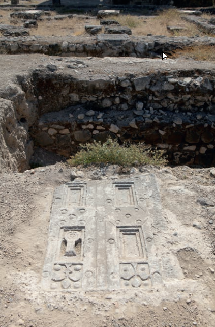
After the mosque was abandoned, most likely following partial destruction by the earthquake in 1068 CE, what remained of its northern section was reoccupied during the Crusader–Ayyubid period (twelfth–early thirteenth century). The debris was not removed, thus creating spaces at different levels, connected by steps when necessary. In one such room, a Jewish tomb door of the Roman period, most probably removed from the mosque and thus in tertiary use, was laid as a first step. It is unique, bearing a menorah contained in a round medallion (fig. Q). While it is not clear if its choice as a first step was intentional, its life cycle is clearly representative of the cultural and religious changes in Tiberias throughout the ages.
Footnotes

61. Cytryn-Silverman, "Umayyad Mosque of Tiberias," 38–44.

62. License W-30/1934. See Hirschfeld, Excavations at Tiberias, 1989–1994, 19–21.

63. Fanny Vito, "HaShuk Ha'ironi" ("The Municipal Market"), HA-ESI 23 (1972).

64. Hartal, "Tiberias."

65. Cytryn-Silverman, "Umayyad Mosque of Tiberias," 40–41.

66. Hartal, Amos, and Hillman, "Tiberias."

67. Stacey, Excavations at Tiberias, 1973–1974, 30.

68. Hartal, Amos, and Hillman, "Tiberias."

69. Stacey, Excavations at Tiberias, 1973–1974, 37–38.

70. Atrash, "Roman Theatre of Tiberias," 86–88.

71. Yizhar Hirschfeld and Oren Gutfeld, Tiberias: The House of the Bronzes I (Qedem 48; Jerusalem: Institute of Archaeology, Hebrew University of Jerusalem, 2008).

72. Briefly excavated by B. Ravani before his sudden death, and continued by me in 2012 and 2013 (Area M4).

73. Hartal, "Tiberias," 2013. See also report of the 2006 dig at the municipal park (license no. A-4886), Moshe Hartal, "Tiberias," HA-ESI 120 (2008): http://www.hadashot-esi.org.il/report_detail_eng.aspx?id=938&mag_id=114.

74. See Cytryn-Silverman, "Umayyad Mosque of Tiberias," 44–56, for a description of the mosque and discussion prior to excavations. See Cytryn-Silverman, "Tiberias and Khirbat al-Minya," for a preliminary discussion of the phases of the mosque following excavations. See also Cytryn-Silverman, "Excavations at Tiberias (Spring and Autumn 2009)," 599–617.

75. Hirschfeld and Gutfeld, "House of the Bronzes," 2053–54; Elias Khamis, The Fatimid Metalwork Hoard from Tiberias (Qedem 55; Jerusalem: Institute of Archaeology, Hebrew University of Jerusalem, 2013).

76. Khamis, Fatimid Metalwork Hoard, 204, no. 566.

77. Foerster, "Tiberias," 1472.

Notes by JW

Cytryn-Silverman (2015:208) discussed rebuilding evidence

The covered hall of the Umayyad mosque was refurbished at some stage by the introduction of a row of columns in the middle of the aisles (see the area marked in dark blue on Mosque Plan in the Photo Gallery, G-2). This probably took place following the earthquake of 749, and aimed at giving extra support to the roof. The final stage of the mosque, apparently a renovation during the early eleventh century (perhaps following the earthquake of 1033?), canceled the extra row and returned the building to the monumentality of the Umayyad period.

Canceled Row Earthquake (?) - 11th century CE

Discussion

Discussion

References
Notes by JW

Cytryn-Silverman (2015:208) discussed rebuilding evidence

The covered hall of the Umayyad mosque was refurbished at some stage by the introduction of a row of columns in the middle of the aisles (see the area marked in dark blue on Mosque Plan in the Photo Gallery, G-2). This probably took place following the earthquake of 749, and aimed at giving extra support to the roof. The final stage of the mosque, apparently a renovation during the early eleventh century (perhaps following the earthquake of 1033?), canceled the extra row and returned the building to the monumentality of the Umayyad period.

Mosque Abandonment Earthquake (?) - 11th century CE

Discussion

Discussion

References
Notes by JW

Cytryn-Silverman (2015:209) discussed abandonment of the mosque

After the mosque was abandoned, most likely following partial destruction by the earthquake in 1068 CE, what remained of its northern section was reoccupied during the Crusader– Ayyubid period (twelfth–early thirteenth century). The debris was not removed, thus creating spaces in different levels, connected by steps when necessary.

Archaeoseismic Effects
Mosque Abandonment Earthquake (?) - 11th century CE

Effect                               Location Image(s) Description
  • Collapsed Walls
  • Debris (due to Collapsed Walls)
Congregational Mosque Fig. 2
  • "After the mosque was abandoned, most likely following partial destruction by the earthquake in 1068 CE, what remained of its northern section was reoccupied during the Crusader–Ayyubid period (twelfth–early thirteenth century). The debris was not removed, thus creating spaces in different levels, connected by steps when necessary." - Cytryn-Silverman (2015:209)
  • Cracked Floor
  • Collapsed Walls (collapsed rubble)
  • Collapsed Roof (broken roof-tiles)
  • Objects of value found in the debris
Square M-21
Fig. 2

Fig. 3
  • "In Phase 4 of the building (fig. 2: in turquoise), apparently towards the 10th century if to follow al-Muqaddasi’s description, the monumentality of Tiberias’ Friday Mosque appears to have been reestablished as it returned to the three-aisled plan of Phase 2. Its latest use has been dated by a billon of Caliph al-Mustans ir Billah found in square M-21 in the disturbed fill under the latest floor. The plaster floor, which was laid over a layer of cobblestones, displayed at this square a clear crack opened by an earthquake. This seems to be the one which caused the mosque to collapse in 1068, burying under the collapsed rubble and broken roof-tiles many fragments of brass chains and of glass mosque-lamps that were once suspended from the ceiling." - Cytryn (2016:118)

Archaeoseismic Intensity Estimates
Mosque Abandonment Earthquake (?) - 11th century CE

Effect                               Location Image(s) Description Intensity
  • Collapsed Walls
  • Debris (due to Collapsed Walls)
Congregational Mosque Fig. 2
  • "After the mosque was abandoned, most likely following partial destruction by the earthquake in 1068 CE, what remained of its northern section was reoccupied during the Crusader–Ayyubid period (twelfth–early thirteenth century). The debris was not removed, thus creating spaces in different levels, connected by steps when necessary." - Cytryn-Silverman (2015:209)
  • VIII+
  • VIII+
  • Cracked Floor
  • Collapsed Walls (collapsed rubble)
  • Collapsed Roof (broken roof-tiles)
  • Objects of value found in the debris
Square M-21
Fig. 2

Fig. 3
  • "In Phase 4 of the building (fig. 2: in turquoise), apparently towards the 10th century if to follow al-Muqaddasi’s description, the monumentality of Tiberias’ Friday Mosque appears to have been reestablished as it returned to the three-aisled plan of Phase 2. Its latest use has been dated by a billon of Caliph al-Mustans ir Billah found in square M-21 in the disturbed fill under the latest floor. The plaster floor, which was laid over a layer of cobblestones, displayed at this square a clear crack opened by an earthquake. This seems to be the one which caused the mosque to collapse in 1068, burying under the collapsed rubble and broken roof-tiles many fragments of brass chains and of glass mosque-lamps that were once suspended from the ceiling." - Cytryn (2016:118)
  • VI+
  • VIII+
  • VII+
  • ?
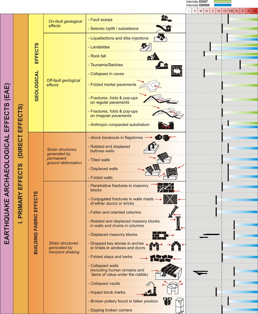
This archaeoseismic evidence requires a minimum Intensity of VIII (8) when using the Earthquake Archeological Effects chart of Rodríguez-Pascua et al (2013: 221-224).

Notes and Further Reading
References