Pella
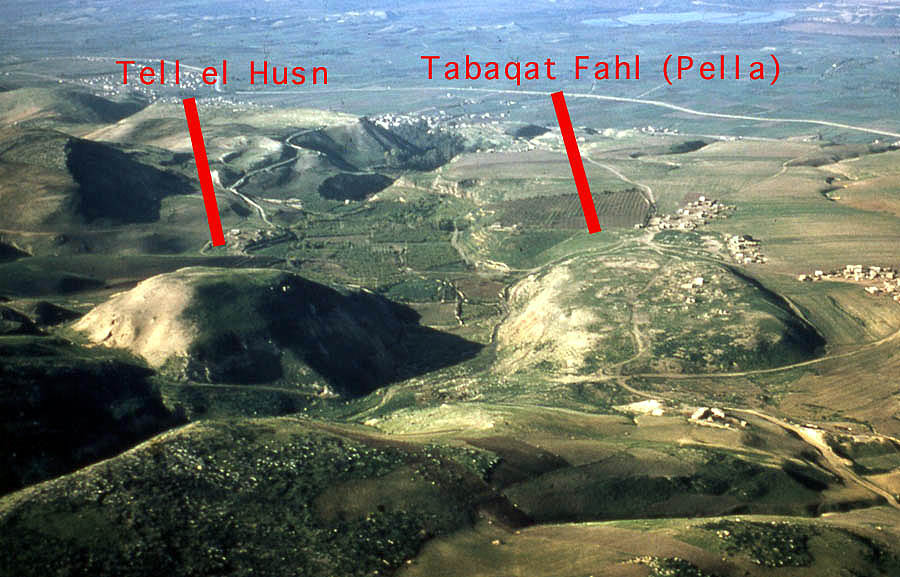 Oblique aerial photograph looking west towards the Jordan River Valley.
This image is scanned from a 1970 era slide taken by Professor Jim Sauer (University of Pennsylvania)
showing the relationship of the two settlement areas at Pella in Jordan.
Oblique aerial photograph looking west towards the Jordan River Valley.
This image is scanned from a 1970 era slide taken by Professor Jim Sauer (University of Pennsylvania)
showing the relationship of the two settlement areas at Pella in Jordan.Dr. Michael J. Fuller
| Transliterated Name | Language | Name |
|---|---|---|
| Pella | Greek | Πέλλα |
| Fahl | Hebrew | פחל |
| Fāhl or Fihl | Arabic | فاهل or فيهل |
| Khīrbīt Fāhl | Arabic | كهيربيت فاهل |
| Tabaqat Fāhl | Arabic | تاباقات فاهل |
| Pihil(um) | Ancient Semitic | |
| Berenike | ||
| Philippeia |
- Fig. 0.1 Main sites
in the southern Levant from Tidmarsh (2024)
 Figure 0.1
The southern Levant, showing main sites mentioned in the text.
Tidmarsh (2024) - Fig. 4.7 Pre and Post 749 features
of Islamic Pella (Fihl) from Blanke and Walmsley (2022)

Figure 4.7
Features of pre- and post-749 Islamic Fiḥl. Note all height measurements are minus (below sea level).- Early Islamic commercial centre [khan] composed of two compounds, eight to tenth centuries (partially excavated), -44 m
- courtyard house, damaged in the 659 earthquake, -43 m
- central church and Odeon, -54 m, west (left) of which lies the heavily silted Wādī al-Jirm’, -60 m
- East church, damaged in the 659 tremor and perhaps destroyed by the 749 earthquake, -20 m
- eastern tall residential quarter of the early sixth century, damaged in 659 tremor, destroyed in 749, with evidence for a ninth century rebuilding in the southern part, -42 m
- extremely abraded occupation area of surfaces, floors,stone wall stubs and deep refuse pits dating to the eighth/ninth to eleventh centuries, -38 m
- buildings with late tenth to eleventh century lustre-decorated glass and, north of the number, a later mosque of probable twelfth century date, -43 m
- west residential quarter (excavation back-filled),destroyed in 749, -51 m
- West church, evidence for earlier earthquake(s), probably 659, then great damage in 749, -60 m
- policing and administrative garrison on the summit of Tall al-Ḥuṣn, destroyed in 659 and not rebuilt
-2 m (Base image: Google Earth, 20 August 2021).
Blanke and Walmsley (2022) - Map of Pella and
environs from Schumacher (1888)
 Map of Pella and environs
click on image to open a magnifiable version in a new tab
Schumacher (1888) - Fig. 24 Topographic
Map of the Jordan Valley surrounding Pella from Smith (1973)
 Figure 24
Topographical Map of a part of the Jordan Valley, showing Pella, Beth-shan, and Gadara
Smith (1973) - Fig. 25 Geologic
Map of the Jordan Valley surrounding Pella from Smith (1973)
 Figure 25
Geological Map of the northern Jordan Valley at contour intervals of 300 m
Smith (1973)
- Fig. 0.1 Main sites
in the southern Levant from Tidmarsh (2024)
Figure 0.1
The southern Levant, showing main sites mentioned in the text.
Tidmarsh (2024) - Fig. 4.7 Pre and Post 749
features of Islamic Pella (Fihl) from Blanke and Walmsley (2022)
Figure 4.7
Features of pre- and post-749 Islamic Fiḥl. Note all height measurements are minus (below sea level).- Early Islamic commercial centre [khan] composed of two compounds, eight to tenth centuries (partially excavated), -44 m
- courtyard house, damaged in the 659 earthquake, -43 m
- central church and Odeon, -54 m, west (left) of which lies the heavily silted Wādī al-Jirm’, -60 m
- East church, damaged in the 659 tremor and perhaps destroyed by the 749 earthquake, -20 m
- eastern tall residential quarter of the early sixth century, damaged in 659 tremor, destroyed in 749, with evidence for a ninth century rebuilding in the southern part, -42 m
- extremely abraded occupation area of surfaces, floors,stone wall stubs and deep refuse pits dating to the eighth/ninth to eleventh centuries, -38 m
- buildings with late tenth to eleventh century lustre-decorated glass and, north of the number, a later mosque of probable twelfth century date, -43 m
- west residential quarter (excavation back-filled),destroyed in 749, -51 m
- West church, evidence for earlier earthquake(s), probably 659, then great damage in 749, -60 m
- policing and administrative garrison on the summit of Tall al-Ḥuṣn, destroyed in 659 and not rebuilt
-2 m (Base image: Google Earth, 20 August 2021).
Blanke and Walmsley (2022) - Map of Pella and
environs from Schumacher (1888)
Map of Pella and environs
click on image to open a magnifiable version in a new tab
Schumacher (1888) - Fig. 24 Topographic
Map of the Jordan Valley surrounding Pella from Smith (1973)
Figure 24
Topographical Map of a part of the Jordan Valley, showing Pella, Beth-shan, and Gadara
Smith (1973) - Fig. 25 Geologic
Map of the Jordan Valley surrounding Pella from Smith (1973)
Figure 25
Geological Map of the northern Jordan Valley at contour intervals of 300 m
Smith (1973)
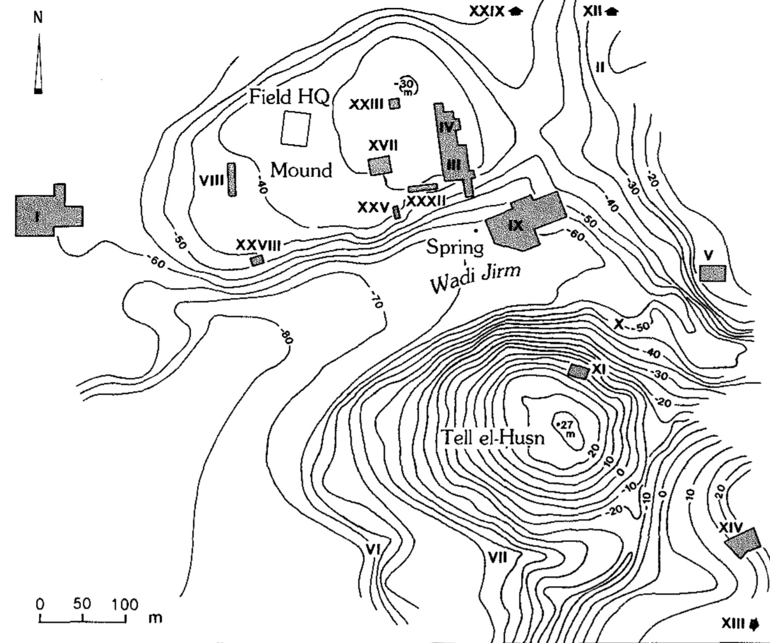
- Pella and Tell el-Husn in Google Earth
 Pella and Tell el-Husn in Google Earth
click on image to explore this site on a new tab in Google Earth - Oblique Aerial View of
Areas III, IV, and IX from the Pella Project - University of Sydney
- Oblique Aerial View of
Areas III and IV from the Pella Project - University of Sydney
- Fig. 2 - View of Area XXXII temple precinct
from Bourke (2004)
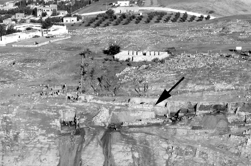 Fig. 2
View of Area XXXII temple precinct.
Bourke (2004) - Plate 1B The Civic Complex
in the spring of 1983, near the end of four seasons of excavation from Smith et al. (1989)
 Plate 1B
The Civic Complex in the spring of 1983, near the end of four seasons of excavation.
Smith et al. (1989) - Plate 13B Aerial View of the
Area IX Civic Complex Church during excavation from Smith et al. (1989)
 Plate 13B
The western approach to the [Area IX Civic Complex] Church during excavation (aerial view). The paving at the foot of the staircase has not yet been exposed. In the upper part of the photograph is the atrium. The arch stones lying on the paving of the atrium have been reassembled; most of them were found in the same part of the atrium, but in greater disorder (see Fig. 10)
Smith et al. (1989) - Fig. 4 - Photo of the Pella Houses
A–B in Area IV from Walmsley (2008)
 Fig. 4
View of the Pella Houses A–B in Area IV, after excavation. Part of the section shown in figure 5 remains on the left; note the fallen column (Walmsley).
Walmsley (2008) - Fig. 2 - Photo of Mamluk Mosque
and other structures on main mound at Pella from Walmsley (1997)
 Fig. 2
General view to the north-west of the main archaeological mound at Fahl (Pella), showing the Mamlûk mosque (centre-left), the location of the village (upper centre-right) and cemetery (upper far right, where the earlier Byzantine–early Islamic housing is exposed)
Photo: S.J. Bourke.
Walmsley (1997


- Map of Pella and environs
from Walmsley and Smith in McNicoll et al (1992)
 Pella and its environs: map of the region and excavation areas. Area IV is at middle top.
Smith in Stern et al (1993) - Fig. 1 - Map of archaeological
areas at Pella from Walmsley (2008)
 Fig. 1
Map of archaeological areas at Pella
Pella Project, modified Walmsley
Walmsley (2008) - Pella contour plan showing
excavation Areas, 2019 from the Pella Project - University of Sydney

- Map of Pella and environs
from Walmsley and Smith in McNicoll et al (1992)
Pella and its environs: map of the region and excavation areas. Area IV is at middle top.
Smith in Stern et al (1993) - Fig. 1 - Map of archaeological
areas at Pella from Walmsley (2008)
Fig. 1
Map of archaeological areas at Pella
Pella Project, modified Walmsley
Walmsley (2008) - Pella contour plan showing
excavation Areas, 2019 from the Pella Project - University of Sydney
- Fig. 3 - General plan of
the Umayyad housing in Area IV from Walmsley (2008)
 Fig. 3
General plan of the Umayyad housing in Area IV (Walmsley)
Walmsley (2008) - Seismic destruction in
Rooms 13, 14, and 15 of House G in Area IV from Walmsley and Smith in McNicoll et al (1992)
 Endplate - Area IV - Plan of House - House G
Walmsley and Smith in McNicoll et al (1992)
- Fig. 3 - General plan of
the Umayyad housing in Area IV from Walmsley (2008)
Fig. 3
General plan of the Umayyad housing in Area IV (Walmsley)
Walmsley (2008) - Seismic destruction in
Rooms 13, 14, and 15 of House G in Area IV from Walmsley and Smith in McNicoll et al (1992)
Endplate - Area IV - Plan of House - House G
Walmsley and Smith in McNicoll et al (1992)
- Sequential phases of six
superimposed Temples at Pella (MBI-Iron II) from Bourke (2013)
 Sequential phases of six superimposed temples showing approximate
position of one above the other from Middle Bronze I to Iron Age II
Sequential phases of six superimposed temples showing approximate
position of one above the other from Middle Bronze I to Iron Age II
Bourke (2013) - Artist’s impression of Pella
"Migdol" Temple in the Middle Bronze Age (1600 BC) from Ben Churcher at Astarte Resources
 An artist’s impression of how the Pella Migdol Temple would have looked during the Middle Bronze Age (1600 BC).
JW: Bourke (2013) identified the 4th phase of the Temples as having theso-called ‘Migdol’ or Fortress Temple form
Ben Churcher at Astarte Resources - Fig. 3 - Schematic plans of
three main phases of temple construction from Bourke (2004)
 Fig. 3
Schematic plans of three main phases of temple construction.
Bourke (2004)
- Sequential phases of six
superimposed Temples at Pella (MBI-Iron II) from Bourke (2013)
Sequential phases of six superimposed temples showing approximate
position of one above the other from Middle Bronze I to Iron Age II
Bourke (2013)
- Fig. 23 - double caravanserai
complex at Pella, 2nd half of the 8th century from Walmsley (2007)
 Fig. 23
Plan of the excavated section of the double caravansery complex at Pella, second half of the eighth century
Walmsley (2007)
- Fig. 23 - double caravanserai
complex at Pella, 2nd half of the 8th century from Walmsley (2007)
Fig. 23
Plan of the excavated section of the double caravansery complex at Pella, second half of the eighth century
Walmsley (2007)
- Plan of West Church
Complex in Area I from Smith (1973)
 Plan of West Church Complex in Area I
Smith (1973) - Fig. 50 Reconstruction
drawing of the West Church Sanctuary and atrium from Smith (1973)
 Figure 50
Reconstruction of the West Church Sanctuary and atrium. The placement of windows is conjectural.
Smith (1973)
- Plan of West Church
Complex in Area I from Smith (1973)
Plan of West Church Complex in Area I
Smith (1973)
- Fig. 2 Simplified Plan
of Area IX from Smith et al. (1989)
 Fig. 2
Simplified plan of Area IX, showing the major features
Smith et al. (1989) - Fig. 18 Detailed Plan
of the "Chamber of Camels" in Area IX with earthquake crushed human and animal skeletons from Smith et al. (1989)
 Fig. 18
Detailed plan of part of the north dependency and Parvis. Locus 50, the "Chamber of the Camels," contains the skeletons of seven camels, a camel foetus, an ass, and Human 2. The small chamber, Locus 43, in the northeast corner of Locus 50, held the skeleton of Human 1. Locus 66, also a chamber, held the skeletons of two cows; the outline of stones beneath the skeletons is somewhat uncertain. Locus 67, a part of the Parvis, had the skeleton of two cows, and Locus 22, an extension of the north dependency, had fragile remains of a horse and a foal. In Locus 23 is the stile across the entrance to the north portal of the atrium, which prevented animals from wandering into the atrium and Church. Excavated portions of drainage channels, declining in a generally westward direction beneath the paving, are indicated by bold straight lines; hypothetical continuations, based on paving patterns, are indicated by rows of dots.
Smith et al. (1989) - Fig. 26 Reconstructed
plan of the Area IX church in Phase 3 from Smith et al. (1989)
 Fig. 26
Reconstructed plan of the church in Phase 3, around A.D. 614 until 658-660. The bema has been extended further west. The reconstruction of the west portico of the atrium is purely conjectural, particularly the walls shown at the top of the small staircase. The precise positions of the columns in the west collonade is not known, and the wall at the north end of the monumental staircase is inferred.
Smith et al. (1989) - Fig. 27 Reconstructed
perspective drawing of the Area IX church in Phase 3 from Smith et al. (1989)
 Fig. 27
Reconstructed perspective drawing of the church in Phase 3. Details of the way in which the arch was installed in the west wall of the atrium are conjectural. The bases and shafts of the collonade at the top of the monumental staircase are shown as being more uniform than they probably were.
Smith et al. (1989) - Fig. 28 Reconstructed
plan of the Area IX church in Phase 4 from Smith et al. (1989)
 Fig. 28
Reconstructed plan of the church in Phase 4, from A.D. 658-660 until 717. The plan remained essentially the same, but with continued deterioration, in Phase 5 (A.D. 717-747). The position of columns in the west collonade of the atrium is somewhat uncertain. The drainage channel in the small chamber in the north dependency continued northwest into the Parvis.
Smith et al. (1989)
- Fig. 2 Simplified Plan
of Area IX from Smith et al. (1989)
Fig. 2
Simplified plan of Area IX, showing the major features
Smith et al. (1989) - Fig. 18 Detailed Plan
of the "Chamber of Camels" in Area IX with earthquake crushed human and animal skeletons from Smith et al. (1989)
Fig. 18
Detailed plan of part of the north dependency and Parvis. Locus 50, the "Chamber of the Camels," contains the skeletons of seven camels, a camel foetus, an ass, and Human 2. The small chamber, Locus 43, in the northeast corner of Locus 50, held the skeleton of Human 1. Locus 66, also a chamber, held the skeletons of two cows; the outline of stones beneath the skeletons is somewhat uncertain. Locus 67, a part of the Parvis, had the skeleton of two cows, and Locus 22, an extension of the north dependency, had fragile remains of a horse and a foal. In Locus 23 is the stile across the entrance to the north portal of the atrium, which prevented animals from wandering into the atrium and Church. Excavated portions of drainage channels, declining in a generally westward direction beneath the paving, are indicated by bold straight lines; hypothetical continuations, based on paving patterns, are indicated by rows of dots.
Smith et al. (1989) - Fig. 26 Reconstructed
plan of the Area IX church in Phase 3 from Smith et al. (1989)
Fig. 26
Reconstructed plan of the church in Phase 3, around A.D. 614 until 658-660. The bema has been extended further west. The reconstruction of the west portico of the atrium is purely conjectural, particularly the walls shown at the top of the small staircase. The precise positions of the columns in the west collonade is not known, and the wall at the north end of the monumental staircase is inferred.
Smith et al. (1989) - Fig. 28 Reconstructed
plan of the Area IX church in Phase 4 from Smith et al. (1989)
Fig. 28
Reconstructed plan of the church in Phase 4, from A.D. 658-660 until 717. The plan remained essentially the same, but with continued deterioration, in Phase 5 (A.D. 717-747). The position of columns in the west collonade of the atrium is somewhat uncertain. The drainage channel in the small chamber in the north dependency continued northwest into the Parvis.
Smith et al. (1989)
- Fig. 5 - Representative
section through Houses A–B from Walmsley (2008)
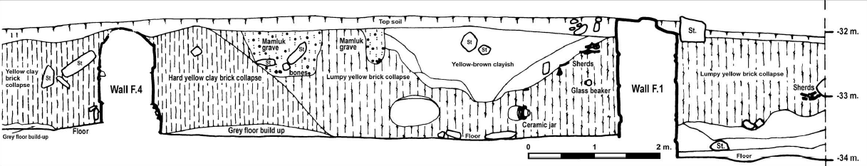 Fig. 5
Representative section through Houses A–B, showing collapse lines and location of objects.
Walmsley (2008) - Fig. 49 Section thru
the east-west elevation line of the West Church and atrium from Smith (1973)
 Figure 49
Section of II S-R along the east-west elevation line through the center of the church and atrium.
Smith (1973) - Fig. 13 Stratigraphic
sections through Area IX Church and Parvis from Smith et al. (1989)

Fig. 13
Stratigraphic sections through A-A' in the sanctuary of the Church, and B-B' in the Parvis (for locations, see plan in Fig. to). Five levels are identified. Note that Level 2 is not present in section B-B'.
- Level 1: Gray topsoil containing small stones and pockets of Marnluk and post-Mamluk sherds.
- Level 2: Hard-packed brown soil, with some gravel; largely sterile but containing some sherds of various periods washed from upslope. (This level is not present in section B-B'.)
- Level 3: Dense, yellowish-brown loess, largely sterile but containing a few Abbasid-Fatimid sherds. At the beginning of this level a robber-pit was cut into level 4.
- Level 4: Debris from the earthquake of A.D. 747, loose, grayish-brown soil with rubble and architectural stones.
- Level 5: Brown, clayey soil containing trash accumulation from the earthquake of A.D. 717, including rubble, roof tile fragments, bits of mosaic, chunks of cement and artifacts (see Pls. 56—57).
Smith et al. (1989) - Fig. 19 Reconstruction
of Phase 3 gallery in the north dependency of the Area IX church from Smith et al. (1989)
 Fig. 19
Reconstruction of the gallery that was constructed in the north dependency during Phase 3 (excavated as Loci 43 and 50), viewed schematically from the north. On the right, behind the upper and lower Ionic colonnade, is the large, reused column of Ajlun limestone that formed the porch of the north portal of the atrium.
(See also the perspective drawing in Fig. 27.)
Smith et al. (1989)
- Destruction layer in Trench XXXIVF 200
showing pottery smash and ashy layer from the Pella Project - University of Sydney
 XXXIV F 200, Destruction layer 224.2 pottery smash on surface also showing ashy layer 224.1 to south
Pella Project - University of Sydney - Umayyad Collapse in Area IV
from the Pella Project - University of Sydney
- Marble paving slabs shattered
in the January 749 CE Holy Desert Quake of the Sabbatical Year Sequence from Smith in ADAJ Plates 1983
 Plate LXXVIII.1
Marble paving slabs in the sanctuary of the Civic Complex Church shattered in the earthquake of A.D. 746/47. The fragments were preserved by a column which collapsed on the slabs.
JW: Actually that earthquake struck in 749
Smith in ADAJ Plates 1983 - Skeletons of camels killed
in the January 749 CE Holy Desert Quake of the Sabbatical Year Sequence from Smith in ADAJ Plates 1983
 Plate LXXXI.2
Skeletons found in the courtyard of the "hall of camels" just north of the Civic Complex Church. The animals are lying as they were killed in the earthquake of A.D. 746/7
JW: Actually that earthquake struck in 749
Smith in ADAJ Plates 1983 - Skeletons of humans killed
in the January 749 CE Holy Desert Quake of the Sabbatical Year Sequence from Walmsley and Smith in McNicoll et al (1992)
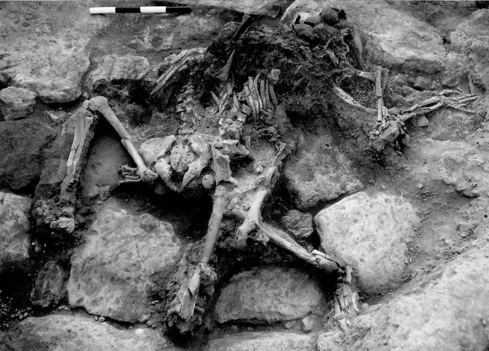 Plate LXXXI.2
Area IV Plot P (extension). Skeletons of two charred adult human beings with covering textiles, found in the AD 746/7 destruction deposit.
JW: Actually that earthquake struck in 749
Walmsley and Smith in McNicoll et al (1992) - Plate 10A Collapse
in the Western Church Complex (Area I) from Smith (1973)
 Plate 10A
I N: view toward the south. One the left is a surviving course of stones of the west front wall of the sanctuary, with the threshold and drain visible. On the right is paving of the atrium colonnade: fallen on the paving is a column drum, and on top of the drum four courses of the collapsed west wall.
Smith (1973) - Plate 12 Phase 4 Collapse
in the Western Church Complex (Area I) from Smith (1973)
 Plate 12
I U: view toward the east. The massive block of fallen masonry on the left and the toppled column drum at the rear are the results of the earthquake which ended phase 4 of the [Western] church's history. The capital in the foreground may belong to the same column.
Smith (1973) - Plate 13B Buttress against
east wall of the sanctuary in the Western Church Complex (Area I) from Smith (1973)
 Plate 13B
I G: view toward the east. Buttress against east wall of the sanctuary, with phase 3 plaster visible.
Smith (1973) - Plate 16A Wall 30 (tilted ?)
from Smith (1973)
 Plate 16A
I E: view toward the east. Wall 30 is on the left. Several original pavers are in situ: above them, in shadow, is a tabun.
Smith (1973) - Plate 18B Dented opus sectile
paving in the Area IX Civic Complex Church from Smith et al. (1989)
 Plate 18B
Extant portion of mosaic I surviving beneath later raised paving in the apse [of the Area IX Civic Complex Church]. East is at the top of the photograph. The cylindrical depression in the opus sectile paving was made by a falling column drum.
Smith et al. (1989) - Plate 19B Spalled column base
from the atrium porch in the Area IX Civic Complex Church from Smith et al. (1989)
 Plate 19B
Base of one of the large columns of the atrium porch [in the Area IX Civic Complex Church].
Smith et al. (1989) - Plate 19C Remains of the
lunate bema in the sanctuary of the Area IX Civic Complex Church from Smith et al. (1989)
 Plate 19C
Remains of the lunate bema in the sanctuary of the [Area IX Civic Complex] Church, with evidence of subsequent modification. Assorted architectural stones were incorporated in the fill around the bema as the floor was raised and enlarged.
Smith et al. (1989) - Plate 26A Segment of
collapsed wall of the central apse of the Area IX Civic Complex Church from Smith et al. (1989)
 Plate 26A
Segment of the collapsed wall of the central apse of the [Area IX Civic Complex] Church between the central and southern windows, resting against the soil of the hillside that rises steeply behind it. on each side, lying on the wide lower portion of the semi-circular apse wall, are small rectangular stones that were part of the windows sills.
Smith et al. (1989) - Plate 37A Skeleton of
a victim of the Phase 5 749 CE earthquake from the Area IX Civic Complex Church from Smith et al. (1989)
 Plate 37A
Three of the five skeletons excavated in the [Area IX] Civic Complex. A. Remains found in the southwest corner of the sanctuary
Smith et al. (1989) - Plate 37B Skeleton of
a victim of the Phase 5 749 CE earthquake from the Area IX Civic Complex Church from Smith et al. (1989)
 Plate 37B
Three of the five skeletons excavated in the [Area IX] Civic Complex. B. Skeleton found in the drainage channel in the triangular chamber.
Smith et al. (1989) - Plate 37C Skeleton of
a victim of the Phase 5 749 CE earthquake from Locus 50 in the "Chamber of the Camels" in the Area IX Civic Complex Church from Smith et al. (1989)
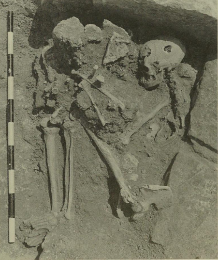 Plate 37C
Three of the five skeletons excavated in the [Area IX] Civic Complex. C. Skeleton found inside the entrance to Locus 50, the Chamber of the Camels.
Smith et al. (1989) - Plate 37D Nose or ear
ring if a a victim of the Phase 5 749 CE earthquake from Locus 50 of the "Chamber of the Camels" in the Area IX Civic Complex Church from Smith et al. (1989)
 Plate 37D
Gold ear or nose ring (45134) found with the skeleton in Locus 50 [the "Chamber of the Camels" in the north dependency of the [Area IX] Civic Complex Church; length 18 mm
Smith et al. (1989) - Plate 39A Skeletons of
camel victims of the Phase 5 749 CE earthquake from Locus 50 in the "Chamber of the Camels" in the Area IX Civic Complex Church from Smith et al. (1989)
 Plate 39A
View westward into Locus 50, the Chamber of the Camels [in the Area IX Civic Complex], showing several camel skeletons as excavated. The drums of the large columns in the background are in a temporary arrangement, and were subsequently re positioned properly.
Smith et al. (1989) - Plate 39B Skeletons of
camel victims of the Phase 5 749 CE earthquake from Locus 50 in the "Chamber of the Camels" in the Area IX Civic Complex Church from Smith et al. (1989)
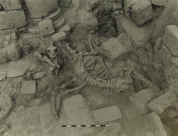 Plate 39B
The intertwined skeletons of Camels B and C [in Locus 50, the "Chamber of Camels" in the Area IX Civic Complex], viewed from the east.
Smith et al. (1989) - Plate 40A Skeleton of
Camel victim A of the Phase 5 749 CE earthquake from Locus 50 in the "Chamber of the Camels" in the Area IX Civic Complex Church from Smith et al. (1989)
 Plate 40A
Camel A skeleton in Locus 50 [the "Chamber of Camels" in the Area IX Civic Complex]
Smith et al. (1989) - Plate 40C Skeleton of
Camel victim F of the Phase 5 749 CE earthquake in the Area IX Civic Complex Church from Smith et al. (1989)
 Plate 40C
Skeleton of Camel F [in the Area IX Civic Complex]
Smith et al. (1989) - Plate 40D Skeleton of
the foetus of Camel victim B of the Phase 5 749 CE earthquake from Locus 50 in the "Chamber of the Camels" in the Area IX Civic Complex Church from Smith et al. (1989)
 Plate 40D
Skeleton of foetus of Camel B in Locus 50 [the "Chamber of Camels" in the Area IX Civic Complex]
Smith et al. (1989) - Plate 40E Skeletons of
Camel victims D and E and an Ass from the Phase 5 749 CE earthquake in the Area IX Civic Complex Church from Smith et al. (1989)
 Plate 40E
Ass Skeleton, with legs of Camel E at upper left and the skeleton of Camel D at right [in the Area IX Civic Complex]
Smith et al. (1989)

 Table I
Area III: Stratigraphic Summary
Bourke, Sparks, and Schroder (2006)
- from Tidmarsh (2024)
 Table 1.1
Pella: Summary of Hellenistic and Early Roman Occupation Sequence
College of Wooster and University of Sydney excavations.
Tidmarsh (2024)
- from Watson (1992:234)
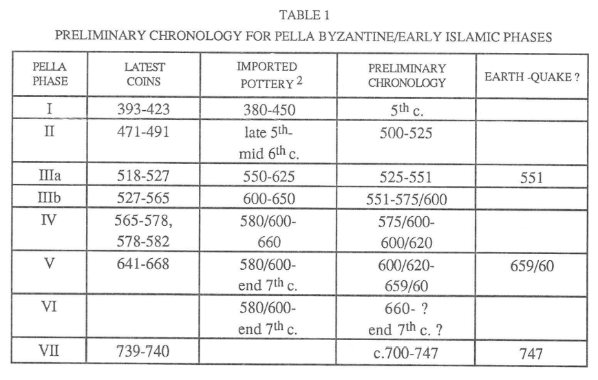 Table 1
Preliminary Chronology for Pella Byzantine/Early Islamic Phases
Watson (1992)
- Fig. 1 - Pella contour plan/area locations
from Bourke (2004)
 Fig. 1
Pella contour plan/area locations
Bourke (2004) - Fig. 7 - Plot IIIC.
Plan of Phase VIII architecture from Walmsley et. al. (1993:179)
 Fig. 7
Plot IIIC. Plan of Phase VIII architecture
Walmsley et. al. (1993:179)
AREA III AND IV EXCAVATIONS
...
Middle Bronze Age IIA-IIA: Plot IIIC (East Cut Phases VIII-X)21
Phase VIII: MBIIB
At the beginning of the Tenth season, Plot IIIC was divided in half some four metres south of the north section line, and only the southern half of the trench was excavated.
Slightly over 1.25 m of deposit was removed in what was called IIIC South, exposing the very fragmentary remains of Phase VIII architecture (Fig. 7; pottery, Fig. 12:9-11).22 This architecture consisted of east-west Wall 47, and bonded into it, north-south Wall 49. Both were fairly insubstantial 40-60 cm wide walls, made up of small and medium fieldstone foundations, topped with patches of yellow and brown mudbricks. Both walls were preserved to a maximum height of 50 cm. Linking the walls together was a good rammed clay floor, 47.5. Set into this surface, in the northwest comer of the room formed by Walls 47/49, was a tabun, F.97. The probable stone paved doorway leading north from the centre of Wall 47 was disturbed by the Phase VI Pit F.75. The eastern end of Wall 47 was difficult to determine with precision, as most of the eastern metre of the wall had collapsed to the south in antiquity. However, the line itself was not in doubt, nor was the fact that it abutted the main city wall, Wall 41. In this collapse, a quantity of mudbrick debris (45.7/ 45.10) had been deposited on occupation buildup (47.2), on the floor 47.5. In colour and texture, the debris so resembled the city-wall that it seems likely that it fell from the wall's western face. The mudbrick and stone debris from Walls 41 and 47 suggest that Phase VIII was rendered uninhabitable through earthquake activity.
Intermediate Phase: MBIIB/C Burials
At some time after the abandonment of the Phase VIII architecture (Walls 47/49), and in a still obscure period before the extensive levelling associated with the construction of the Phase VII architecture (Walls 40/42/43), this area of the tell was used as a burial ground. A first intramural burial (F.98) was discovered in the northwestern margins of IIIC South, during the Tenth season (Fig. 8). This contained the body of an adult male, portions of a goat, and some sixteen ceramic vessels (ten juglets, three jugs and three bowls; for a selection see Fig. 13), a dagger and pommel, and flint (firelighter?).
Although it was the intention to leave the northern half of IIIC unexcavated for the present, erosion at the beginning of the Twelfth season revealed an elaborate multi intramural burial (F.106) several centimetres below the limit of excavation in 1986 (Fig. 9). This, too, is to be dated to the "interphase" between VIII/VII, and with more confidence, as the foundation trench for Phase VII Wall 42 cuts the northwestern margins of this second grave. It contained the articulated skeletons of at least three individuals, two adult females and an infant child. The easternmost adult is only partially preserved, as the margins of the grave were disturbed by Phase VII levelling, Phase VI Pit feature 75, and modern erosion. The grave also contained some twenty-two ceramic vessels (six jugs, three dipper juglets, six juglets, five carinated bowls, two platter bowls), two of which - a platter bowl and a globular juglet - were of the well known Tell al-Yahudiyeh Ware (Fig. 14). As the grave lay barely 20 cm below the Phase VII walls and surfaces, it seems likely that extensive levelling of the area occurred before Phase VII was constructed. The difference in time, based on ceramic evidence, does not seem to have been great, however, as the grave goods are best seen as Late MBIIB, and Phase VII ceramics placed early in MBIIC.
Probably to be associated with this "intermediate" phase is a third burial (F.107) cut through, and badly disturbed by a robber (?) pit feature 96. Feature 107 was a cist burial, lined with a single row of well formed yellow mudbricks on its north and south sides. Only the northern half of the burial, containing the articulated upper body of what is likely to be an adult female, was left relatively undisturbed. Fragments remained of a second adult burial (sex indeterminate) in the southern margins of the cist. Grave goods consisted of a jug and a juglet.
- Table I Area III:
Stratigraphic Summary from Bourke, Sparks, and Schroder (2006)
Table I
Area III: Stratigraphic Summary
Bourke, Sparks, and Schroder (2006) - Fig. 7 Plans of five major
Middle Bronze Age Phases in Area III from Bourke, Sparks, and Schroder (2006)
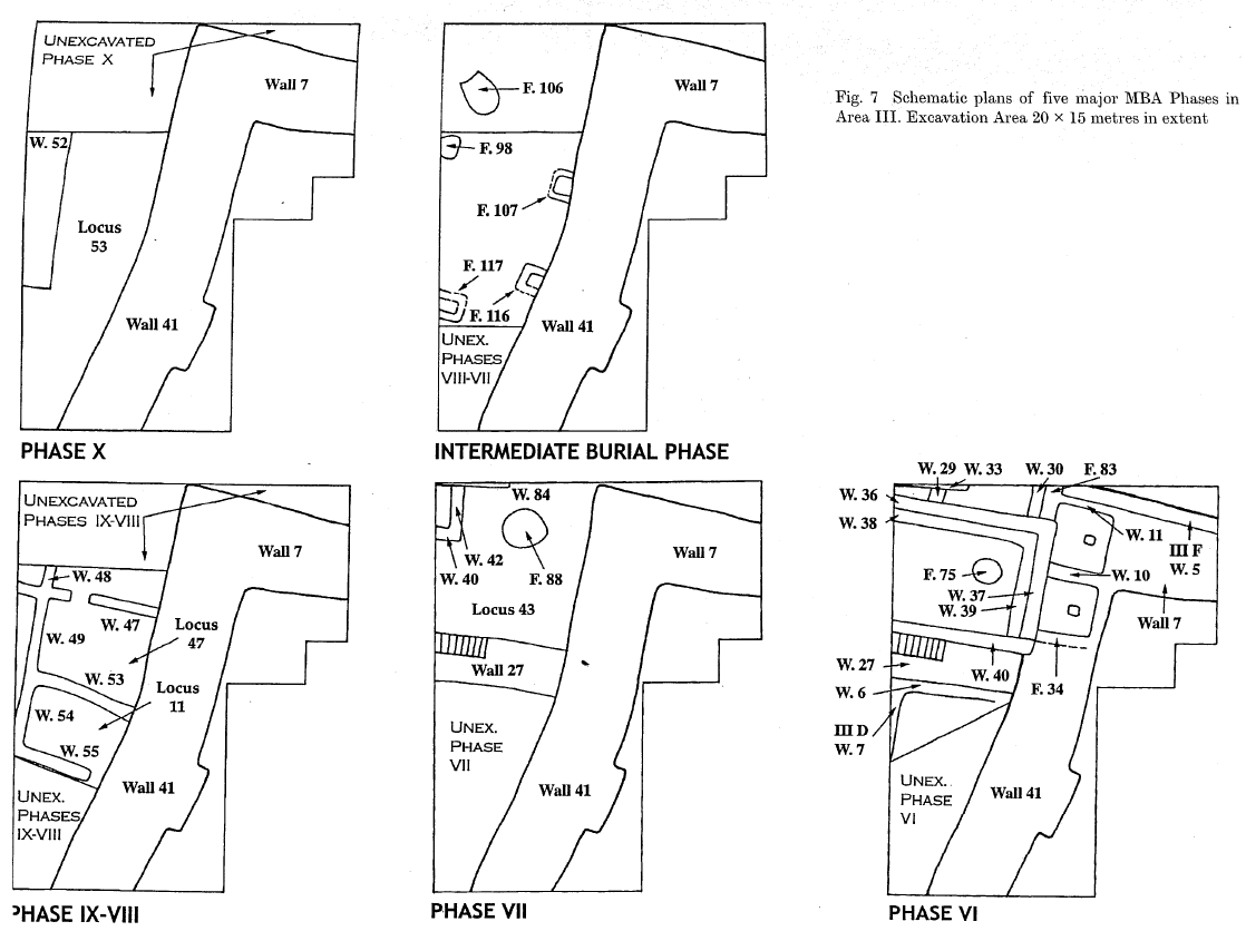 Fig. 7
Schematic plans of five major MBA Phases in Area III. Excavation Area 20 x 15 metres in extent
Bourke, Sparks, and Schroder (2006) - Fig. 7 Closeup - Plan of Phase VI
in Area III from Bourke, Sparks, and Schroder (2006)
 Fig. 7 Closeup
Schematic plan of Phase VI in Area III. Excavation Area 20 x 15 metres in extent
Bourke, Sparks, and Schroder (2006) - Fig. 17 City Wall 41 Phase VII repair
in Area III from Bourke, Sparks, and Schroder (2006)
 Fig. 17
View of City Wall 41 Phase VII repair, built against main inner wall face in centre background, looking east
Bourke, Sparks, and Schroder (2006)
3. AREA III: THE MIDDLE BRONZE AGE STRATIGRAPHIC SEQUENCE
... Phase VII (Figs. 17, 20, 25)
Wall 27 (Early), Walls 42-44, Oven F.88, Brick Wall F.84 and Associated Deposits
Phase VII constructions were very badly disturbed by numerous deep foundation trenches resulting from the multiple phases of substantial building activity in the succeeding Phase VI. Phase VII is made up of north-south Wall 42 and east-west Wall 44, forming part of a small room in the north-west corner of the trench. Associated with this phase is a very large circular pebble-paved oven (F.88), which takes up much of the area east of Wall 42. To the north of the oven, an east-west yellow mudbrick wall (F.84) is preserved in the north baulk, and to the south fragments of a second east-west Wall 43 make up the north and south sides of the `oven room'. A series of good plaster surfaces (43.10, 43.7, 43.2) provide a well separated occupational sequence, with 43.10 probably constructional for all features, and 43.2 the last good surface in the area. On the southern margins of the trench, a large e/w mudbrick wall, Wall 27, marks the southern limits of the Phase VII complex outlined above (Fig. 19). It seems possible that an east-west passageway ran along the outer southern face of this wall. All Phase VII deposits south of this passageway were lost to erosion.
Phase VI (Figs. 19, 21-25)
Phase VI has at least three subphases. Two represent double-wall reconstructions cut through earlier sub-phases. Several walls have substantial foundation trenches, and a number of deep pits complicate interpretation. Consequently, there are many small patches of floor surfaces associated with each of the several major and many minor alterations to the basic Phase VI groundplan. To complicate matters further, the even more massive stone foundations for the subsequent Phase V "Governor's Residence" complex fragment further an already complex stratigraphic sequence.
MAGNESS-GARDINER's (1997: 312) recent review of the Pella Phase VI stratigraphy is in error in all major points. Phase VI is not MB I in date, and is not associated with the primary construction of the city fortifications, rather with their end. Magness-Gardiner also confuses the main Phase VI architecture with later Phase V deposits. Confusion is heightened by her association of the Phase V Lion Box and cuneiform tablet deposits (Porrs 1987) with Phase VI architecture.
Phase VI C
Walls 10, 11 and F.34; Wall 27 (Late) and Associated Deposits
The monumental east-west mudbrick Wall 27, which delimited the southern complex wall in the preceding Phase VII, is thickened and its superstructure re-bricked at the beginning of Phase VI. It is possible that this re-bricking includes an east-west mudbrick staircase up to a north-south walkway, running along the inner line of the city fortification wall. A series of small cubicles (Walls 10 and 11, and F.34) were constructed in the northern margins of the walkway, probably during this phase, or just possibly in the subsequent rebuild. The foundations of the Phase V "Governor's Residence" complicates interpretation at this point.
At some stage during the life of these structures, but after the re-laying of several floors, a severe earthquake (?) destruction resulted in significant damage to the entire complex. Both Wall 27 and the city wall (Wall 41) suffered major structural damage. Several large pieces of the inner face of the city wall fractured and collapsed onto floor surfaces. The three small cubicles built against the inner face of the city wall suffered a fiery destruction, with clear evidence of wall and floor fracturing, and much broken pottery and other objects sealed by a thick brick-filled debris layer.
Phase VI B (Figs. 22-24)
III C Walls 36-40; III D Walls 6 and 7; III F Wall 5; Features 71, 83 (Fig. 18) and 85, and Associated Deposits
Following the earthquake damage, the whole complex was rebuilt. Internal structural mudbrick wall patch (F.85) and buttress (F.83) were added to the inner face of the city wall (Wall 41), and the east-west passageway along the inner face of III F Wall 7 was probably blocked. Wall 27 was cut down and rebuilt, with stone buttresses along its north (III C F.71) and south (III D Wall 6) faces shoring up the original mudbrick wall. In the central area of the trench west of the city wall and north of the rebuilt Wall 27, a substantial square double-walled room (III C Walls 36, 37 and 40 and III D Wall 7) was constructed in stone and mudbrick, faced with thick mudplaster, and provided with benches along the north (Wall 38) and east (Wall 39) interiors. No more than small scraps of a build-up of surfaces were preserved against the south face of III D Wall 6. All other deposits were lost to erosion.
The walkway and the cubicle rooms along the inner face of the north-south city wall (Wall 41) were never repaired. It seems probable that the entire region east of Wall 41 was rebuilt along different lines. A mudbrick buttress wall (III F Wall 5) was cut down against the inner northern face of III F Wall 7. Along with the III C corner buttress F.83, both constructions probably aimed at strengthening the east-west circuit wall, III F Wall 7. The north baulk intervenes at this point, so it remains unclear whether III C Buttress F.83 and III F Bench Wall 5 merely narrowed the east-west passageway, or sealed it off completely. However, subsequent deep fill layers devoid of occupational surfaces suggest infilling with Middle/Late Bronze Age tip/rubbish deposits, making it likely that the area went out of use at this point.
- Table I Area III:
Stratigraphic Summary from Bourke, Sparks, and Schroder (2006)
Table I
Area III: Stratigraphic Summary
Bourke, Sparks, and Schroder (2006) - Fig. 7 Plans of five major
Middle Bronze Age Phases in Area III from Bourke, Sparks, and Schroder (2006)
Fig. 7
Schematic plans of five major MBA Phases in Area III. Excavation Area 20 x 15 metres in extent
Bourke, Sparks, and Schroder (2006) - Fig. 7 Closeup - Plan of Phase VI
in Area III from Bourke, Sparks, and Schroder (2006)
Fig. 7 Closeup
Schematic plan of Phase VI in Area III. Excavation Area 20 x 15 metres in extent
Bourke, Sparks, and Schroder (2006) - Fig. 17 City Wall 41 Phase VII repair
in Area III from Bourke, Sparks, and Schroder (2006)
Fig. 17
View of City Wall 41 Phase VII repair, built against main inner wall face in centre background, looking east
Bourke, Sparks, and Schroder (2006)
At some stage during the life of these structures, but after the re-laying of several floors, a severe earthquake (?) destruction resulted in significant damage to the entire complex. Both Wall 27 and the city wall (Wall 41) suffered major structural damage. Several large pieces of the inner face of the city wall fractured and collapsed onto floor surfaces. The three small cubicles built against the inner face of the city wall suffered a fiery destruction, with clear evidence of wall and floor fracturing, and much broken pottery and other objects sealed by a thick brick-filled debris layer.Wall 41 runs N-S and Wall 27 runs E-W.
- from Bourke (2004)
- Fig. 1 - Pella contour plan/area locations
from Bourke (2004)
Fig. 1
Pella contour plan/area locations
Bourke (2004) - Fig. 2 - View of Area XXXII temple precinct
from Bourke (2004)
Fig. 2
View of Area XXXII temple precinct.
Bourke (2004) - Fig. 3 - Schematic plans of
three main phases of temple construction from Bourke (2004)
Fig. 3
Schematic plans of three main phases of temple construction.
Bourke (2004)
- Fig. 2 - Sketch plan of
Husn trenches: Bronze Age deposits highlighted from Bourke, Sparks, and Mairs (1999)
 Fig. 2
Sketch plan of Husn trenches: Bronze Age deposits highlighted (not to scale).
Bourke, Sparks, and Mairs (1999) - Fig. 3 - Sketch plan of
platform and gatehouse complex from Bourke, Sparks, and Mairs (1999)
 Fig. 3
Sketch plan of platform and gatehouse complex (not to scale).
Bourke, Sparks, and Mairs (1999) - Fig. 4 - Plan of Middle
and Late Bronze Age structures in Trench XXXIVF from Bourke, Sparks, and Mairs (1999)
 Fig. 4
Trench XXXIVF. Plan of Middle and Late Bronze Age structures (1:100).
Bourke, Sparks, and Mairs (1999) - Plate 7.2 - MBA Stone terracing
and LBA Silo in Trench XXXIVF from Bourke, Sparks, and Mairs (1999)
 Plate 7.2
Tell Husn (Pella). Trench XXXIVF. MBA Stone terracing and LBA Silo.
Bourke, Sparks, and Mairs (1999) - Plate 8.1 - Trench XXXIVF
LBA Structures canted over (to left) in earthquake from Bourke, Sparks, and Mairs (1999)
 Plate 8.1
Tell Husn (Pella). Trench XXXIVF. LBA Structures canted over (to left) in earthquake.
Bourke, Sparks, and Mairs (1999)
1. TRENCH XXXIVF: THE MIDDLE AND LATE BRONZE AGE FORTRESS
A 4 x 11 m trench (XXXIVF) was opened north of the Byzantine fortress wall in 1993 to explore promising Hellenistic deposits outside the fort. Whilst the Hellenistic materials proved to be a thin rubbish deposit, a dense complex of stone-lined bins and a thoroughfare were uncovered and dated to the MB/LB period.4 In 1994, trench XXXIVF was expanded eleven metres to the east, thereby forming a 15 x 11 m exposure exploring virtually all of the remaining summit north and east of the massive Byzantine fortress (fig. 3). As well, a 2 x 4 m extension in the north-west corner was opened to investigate the very large Bronze Age border wall (Wall 1) detected in 1993.
Excavations in the western half of the extended XXXIVF quickly isolated a series of walls, bins, and stone pavements of MB/LB date, whilst excavations in the the eastern half exposed EBA mud-brick debris and ashy deposits immediately below the thin Late Byzantine/Hellenistic debris layers (fig. 4).
The western complex (fig. 4; pls. 7:2; 8:1) consists of a single main constructional phase, and at least two phases of rebuilding. Between the construction and last rebuilding phases, and probably associated with the first rebuilding phase, a series of single inhumation burials were discovered, dug into the constructional material, and in at least two cases sealed by walls of the final rebuilding phase. The constructional phase dates within the MBIIC period, the first major rebuilding dates from the MB/LB period, and the second (relatively minor) rebuilding to the LBIIA period. The entire complex was destroyed in a massive earthquake, probably dating towards the end of the LBIIA period, based on pottery sealed in destruction layers (fig. 5).
A hoard, consisting of eleven leaf-shaped arrowheads of copper alloy and three stunning bolts, all in an excellent state of preservation, (fig. 6) was recovered from the lip of one of two large stone-lined storage bins (Feature 6: fig. 4; pl. 7: 2). The uniformity of the collection suggests that they may have been from a quiver of weapons. The hoard dates to the period of the final destruction of the Husn complex by earthquake, based on ceramic evidence (fig. 5). The quiver probably fell into the storage bin during the destruction of the building.
Thickened leaf-shaped arrowheads with a central rib first appear during the LBA, probably in response to the contemporary developments in scale armour. They are frequently found in association with blunt stunning bolts, although these are usually present in smaller quantities. Parallels for both types of projectile are found throughout Syro-Palestine, including Kamid el-Loz,5 the Amman Airport Temple,6 Beth Shan,7 Akko,8 Gezer,9 Lachish,10 Tell Jedur,11 and Tell el-'Ajjul.12
Sealed beneath the later rebuilding phases of the fortress, several burials of infants and young children were uncovered. They were cut into the fabric of the MBA stone foundations, and were sealed by earliest MBA floors. Ceramics from the burials date them to the 17th century BC (MB/LB period).
- from Bourke (2004)
- Fig. 1 - Pella contour plan/area locations
from Bourke (2004)
Fig. 1
Pella contour plan/area locations
Bourke (2004) - Fig. 2 - View of Area XXXII temple precinct
from Bourke (2004)
Fig. 2
View of Area XXXII temple precinct.
Bourke (2004) - Fig. 3 - Schematic plans of
three main phases of temple construction from Bourke (2004)
Fig. 3
Schematic plans of three main phases of temple construction.
Bourke (2004)
- Fig. 1 - Map of archaeological areas
at Pella and environs from Walmsley (2007)
 Figure 1
Map of archaeological areas at Pella
(Pella Project, modified Walmsley).
Walmsley (2007) - Fig. 4.7 - Map of pre- and post-749
Islamic Fiḥl from Blanke and Walmsley (2022)
Figure 4.7
Features of pre- and post-749 Islamic Fiḥl. Note all height measurements are minus (below sea level).- Early Islamic commercial centre [khan] composed of two compounds, eight to tenth centuries (partially excavated), -44 m
- courtyard house, damaged in the 659 earthquake, -43 m
- central church and Odeon, -54 m, west (left) of which lies the heavily silted Wādī al-Jirm’, -60 m
- East church, damaged in the 659 tremor and perhaps destroyed by the 749 earthquake, -20 m
- eastern tall residential quarter of the early sixth century, damaged in 659 tremor, destroyed in 749, with evidence for a ninth century rebuilding in the southern part, -42 m
- extremely abraded occupation area of surfaces, floors,stone wall stubs and deep refuse pits dating to the eighth/ninth to eleventh centuries, -38 m
- buildings with late tenth to eleventh century lustre-decorated glass and, north of the number, a later mosque of probable twelfth century date, -43 m
- west residential quarter (excavation back-filled),destroyed in 749, -51 m
- West church, evidence for earlier earthquake(s), probably 659, then great damage in 749, -60 m
- policing and administrative garrison on the summit of Tall al-Ḥuṣn, destroyed in 659 and not rebuilt
-2 m (Base image: Google Earth, 20 August 2021).
Blanke and Walmsley (2022)
| Location | Image(s) | Description(s) | Source(s) |
|---|---|---|---|
| ‘policing and administrative garrison’ at Tall al-Husn - Fig. 4.7 [10] |
Fig. 4.7 [10]
Features of pre- and post-749 Islamic Fiḥl. Note all height measurements are minus (below sea level).
-2 m (Base image: Google Earth, 20 August 2021). Blanke and Walmsley (2022) |
|
|
| The eastern end of the Pella mound (aka the main mound) - Fig. 4.7 [5] |
Fig. 4.7 [5]
Features of pre- and post-749 Islamic Fiḥl. Note all height measurements are minus (below sea level).
-2 m (Base image: Google Earth, 20 August 2021). Blanke and Walmsley (2022) |
|
|
| The eastern end of the Pella mound (aka the main mound) - Fig. 4.7 [2] |
Fig. 4.7 [2]
Features of pre- and post-749 Islamic Fiḥl. Note all height measurements are minus (below sea level).
-2 m (Base image: Google Earth, 20 August 2021). Blanke and Walmsley (2022) |
|
|
| The valley below the tall - Fig. 4.7 [3] |
Fig. 4.7 [3]
Features of pre- and post-749 Islamic Fiḥl. Note all height measurements are minus (below sea level).
-2 m (Base image: Google Earth, 20 August 2021). Blanke and Walmsley (2022) |
|
- Fig. 1 - Map of archaeological areas
at Pella and environs from Walmsley (2007)
Figure 1
Map of archaeological areas at Pella
(Pella Project, modified Walmsley).
Walmsley (2007) - Fig. 4.7 - Map of pre- and post-749
Islamic Fiḥl from Blanke and Walmsley (2022)
Figure 4.7
Features of pre- and post-749 Islamic Fiḥl. Note all height measurements are minus (below sea level).- Early Islamic commercial centre [khan] composed of two compounds, eight to tenth centuries (partially excavated), -44 m
- courtyard house, damaged in the 659 earthquake, -43 m
- central church and Odeon, -54 m, west (left) of which lies the heavily silted Wādī al-Jirm’, -60 m
- East church, damaged in the 659 tremor and perhaps destroyed by the 749 earthquake, -20 m
- eastern tall residential quarter of the early sixth century, damaged in 659 tremor, destroyed in 749, with evidence for a ninth century rebuilding in the southern part, -42 m
- extremely abraded occupation area of surfaces, floors,stone wall stubs and deep refuse pits dating to the eighth/ninth to eleventh centuries, -38 m
- buildings with late tenth to eleventh century lustre-decorated glass and, north of the number, a later mosque of probable twelfth century date, -43 m
- west residential quarter (excavation back-filled),destroyed in 749, -51 m
- West church, evidence for earlier earthquake(s), probably 659, then great damage in 749, -60 m
- policing and administrative garrison on the summit of Tall al-Ḥuṣn, destroyed in 659 and not rebuilt
-2 m (Base image: Google Earth, 20 August 2021).
Blanke and Walmsley (2022)
Urban Fiḥl was badly impacted, resulting in further and permanent reconfigurations to the town’s layout. Early evidence for this earthquake was identified at the eastern end of the main mound in the 1979 to 1982 seasons (Fig. 4.7 [5]), where a residential area suffered a partial collapse of buildings following which an east–west access street was closed off and multi-roomed houses on two levels repaired and equipped with large private courtyards.51 In the valley below the tall, the central church suffered significant damage that resulted in the permanent blocking of the Western portal only decades old and the reinstatement of the main entrance on the northern side (Fig. 4.7 [3]).52 The colonnade at the top of the church staircase seemingly collapsed at this time. An unwillingness to restore the portico and staircase suggests that the earthquake caused havoc in the valley, with broad evidence for land movement causing architectural slumping and infilling with coarse alluvium and boulders, the remediation of which would have been Sisyphean. Later excavations by Watson on the summit of Tall al-Ḥuṣn (Fig. 4.7 [10]), which commenced in 1988, identified a multi-phase ‘policing and administrative garrison’ similarly destroyed in 659, a date established by secure ceramic comparisons with the corpus from excavations of the eastern residential area on the main mound.53 The site, regardless of its commanding view over the Jordan Valley, was not reoccupied. Likewise, work by da Costa in a third location east of the main mound exposed a derelict courtyard house that was not rebuilt after an apparent mid-seventh-century collapse, although evidence of animal butchering reveals continued use of the space (Fig. 4.7 [2]).54
- Fig. 1 - Map of archaeological areas
at Pella and environs from Walmsley (2007)
Figure 1
Map of archaeological areas at Pella
(Pella Project, modified Walmsley).
Walmsley (2007) - Fig. 3 - General plan of
the Umayyad housing in Area IV from Walmsley (2007)
 Figure 3
General plan of the Umayyad housing in Area IV
(Walmsley).
Walmsley (2007) - Plan of House G from
Walmsley and Smith in McNicoll et al (1992)
Endplate - Area IV - Plan of House - House G
Walmsley and Smith in McNicoll et al (1992) - Plan of House G (magnified)
from Walmsley and Smith in McNicoll et al (1992)
Endplate - Area IV - Plan of House - House G
Walmsley and Smith in McNicoll et al (1992) - Fig. 4 - View of Pella
Houses A–B in Area IV from Walmsley (2007)
 Figure 4
View of the Pella Houses A–B in Area IV, after excavation. Part of the section shown in figure 5 remains on the left; note the fallen column (Walmsley).
Walmsley (2007) - Umayyad Collapse in Area IV
from the Pella Project - University of Sydney
- Marble paving slabs shattered
in the January 749 CE Holy Desert Quake of the Sabbatical Year Sequence from Smith in ADAJ Plates 1983
Plate LXXVIII.1
Marble paving slabs in the sanctuary of the Civic Complex Church shattered in the earthquake of A.D. 746/47. The fragments were preserved by a column which collapsed on the slabs.
JW: Actually that earthquake struck in 749
Smith in ADAJ Plates 1983 - Skeletons of camels killed
in the January 749 CE Holy Desert Quake of the Sabbatical Year Sequence from Smith in ADAJ Plates 1983
Plate LXXXI.2
Skeletons found in the courtyard of the "hall of camels" just north of the Civic Complex Church. The animals are lying as they were killed in the earthquake of A.D. 746/7
JW: Actually that earthquake struck in 749
Smith in ADAJ Plates 1983 - Skeletons of humans killed
in the January 749 CE Holy Desert Quake of the Sabbatical Year Sequence from Walmsley and Smith in McNicoll et al (1992)
Plate LXXXI.2
Area IV Plot P (extension). Skeletons of two charred adult human beings with covering textiles, found in the AD 746/7 destruction deposit.
JW: Actually that earthquake struck in 749
Walmsley and Smith in McNicoll et al (1992)
- from Walmsley (2007)
- Fig. 1 - Map of archaeological areas
at Pella and environs from Walmsley (2007)
Figure 1
Map of archaeological areas at Pella
(Pella Project, modified Walmsley).
Walmsley (2007) - Fig. 3 - General plan of
the Umayyad housing in Area IV from Walmsley (2007)
Figure 3
General plan of the Umayyad housing in Area IV
(Walmsley).
Walmsley (2007) - Plan of House G from
Walmsley and Smith in McNicoll et al (1992)
Endplate - Area IV - Plan of House - House G
Walmsley and Smith in McNicoll et al (1992) - Plan of House G (magnified)
from Walmsley and Smith in McNicoll et al (1992)
Endplate - Area IV - Plan of House - House G
Walmsley and Smith in McNicoll et al (1992) - Fig. 4 - View of Pella
Houses A–B in Area IV from Walmsley (2007)
Figure 4
View of the Pella Houses A–B in Area IV, after excavation. Part of the section shown in figure 5 remains on the left; note the fallen column (Walmsley).
Walmsley (2007) - Umayyad Collapse in Area IV
from the Pella Project - University of Sydney
- Marble paving slabs shattered
in the January 749 CE Holy Desert Quake of the Sabbatical Year Sequence from Smith in ADAJ Plates 1983
Plate LXXVIII.1
Marble paving slabs in the sanctuary of the Civic Complex Church shattered in the earthquake of A.D. 746/47. The fragments were preserved by a column which collapsed on the slabs.
JW: Actually that earthquake struck in 749
Smith in ADAJ Plates 1983 - Skeletons of camels killed
in the January 749 CE Holy Desert Quake of the Sabbatical Year Sequence from Smith in ADAJ Plates 1983
Plate LXXXI.2
Skeletons found in the courtyard of the "hall of camels" just north of the Civic Complex Church. The animals are lying as they were killed in the earthquake of A.D. 746/7
JW: Actually that earthquake struck in 749
Smith in ADAJ Plates 1983 - Skeletons of humans killed
in the January 749 CE Holy Desert Quake of the Sabbatical Year Sequence from Walmsley and Smith in McNicoll et al (1992)
Plate LXXXI.2
Area IV Plot P (extension). Skeletons of two charred adult human beings with covering textiles, found in the AD 746/7 destruction deposit.
JW: Actually that earthquake struck in 749
Walmsley and Smith in McNicoll et al (1992)
6 house units were excavated at the eastern end of the main mound, each buried in a thick destruction deposit from an earthquake dating to the mid-8th c. A.D. (fig.. 1, Area IV
Figure 1Map of archaeological areas at Pella
(Pella Project, modified Walmsley).
Walmsley (2007)
... As has already been noted, graphic archaeological evidence for the severity of the A.D. 749 earthquake has been found in different locations at Pella, notably the church complex in the central valley (Area IX), the West and East churches (Areas I and V), and the domestic quarters on the main mounds (Areas IV and VIII).
... The Pella evidence when revealed in the early 1980s presented a conclusive picture of a simultaneous urban destruction in A.D. 749. First proposed by Smith for the West Church (Area I) in the mid 1970s,18 new work at the central valley church (Area IX) and on the main mound produced much more definitive and illustrative information on urban life at Pella at the time of the mid-8th c. earthquake.
... The cathedral church and related structures excavated by Smith present an intriguing case of urban change after the Islamic expansion. Significant modifications occurred north of the church building, where a paved porticoed court, which coincided with the construction of the church, was modified by the construction of two-storeyed rooms faced with porches and galleries. Standing some 8.5 m high, this structure was clearly of major importance in the life of the town as it flanked the main entrance into the church, and was probably commercial in purpose (fig. 2).19 At least, this would seem to have been its final function on the day the A.D. 749 earthquake struck Pella with all of its intensity. Caught within the collapsing structure were two people and several animals, including 7 camels (one in advanced pregnancy), a horse and foal, an ass, and 4 cows. The age and condition of the camels - juvenile, young adult or in calf - suggests they were being sheltered on a particularly harsh winter’s day [JW: night].20
... With these fatalities of nature were recovered several Umayyad coins, including a dinar (94 A.H./A.D. 712/13) and 14 dirhams (between 81 A.H./A.D. 700/701 and 112 A.H./A.D. 730/31), numerous ceramic vessels and lamps, iron implements including a dagger, a bronze jug and three glass bottles.21 A mass of iron tools was found in a smith’s workshop in the south-west corner of the building, including a pick head, shovel, shears and sledgehammer head. What was happening in the church at this time is disputed (see note 13). In the court preceding the church (Atrium), three iron torch holders were found along with pottery vessels, suggesting a not insignificant level of activity. Within the church building, in the south aisle, the skeletons of two humans were found, but, apart from a few ceramic vessels (including a group of arcane pierced pottery cones), little else, except architectural debris from the collapsed church. Subsequently, from a level above the collapse that contained later Abbasid-Fatimid material, stone was robbed from the destroyed building.22 This pattern of an A.D. 749 collapse and subsequent robbing matches that recognised in Area IV, and further suggests that the looting of the church fixtures did not occur until after the earthquake of A.D. 749.
On the main mound, due to the more complete nature of the deposits, the archaeological sequence is less obscured and the finds more representative, for it was houses - with all their human and material contents - that were lost to the unexpected ferocity of the A.D. 749 quake. In Area IV
(figs. 1
Figure 1Map of archaeological areas at Pella (Pella Project, modified Walmsley).
Walmsley (2007)
Figure 3General plan of the Umayyad housing in Area IV (Walmsley).
Walmsley (2007)
Figure 4View of the Pella Houses A–B in Area IV, after excavation. Part of the section shown in fi gure 5 remains on the left; note the fallen column (Walmsley).
Walmsley (2007)
... House G, as with Houses A and B, has exposed the utter destructiveness inflicted on Pella by the A.D. 749 earthquake. The upper level(s) of brick collapsed instantaneously into the ground floor rooms, trapping people, animals and domestic objects within them; even the chickens pecking about in the central courtyard of House G had no time to flee the tumbling building.
... Entombed on the ground floor level were more domestic items along with many victims of the tragedy, human and animal. Based on the disposition of the artefacts in the collapse and the complete entrapped skeletons on the ground floor, it can be generalised that the downstairs area of the house was devoted to the care of valuable domesticated animals and light workshop activities, whereas the primary living quarters were located upstairs.
The human victims recovered on the ground floor consisted of three adults and a child. A single male was found crouched against the west wall of room 2, with one arm raised above his head in a desperate attempt to protect himself from heavy falling material (fig. 12
 Figure 12
Detailed plan of House G
(Winikoff, modified Walmsley)
Walmsley (2007)
... The victim found in room 2, separated from the inner court by a roughly built dividing wall, may have been living in this downstairs space, perhaps intermittently. A robust adult male aged between 25 and 30 years, both his physique and location near the animals would suggest that he was their carer (a job for which, the 4 dinars would indicate, he was well rewarded).
... Just outside the doorway into room 2, evidence for a small fire was found on the bench against the west wall of the inner courtyard. Probably being used for cooking rather than heating, the fire ignited the collapsed building debris in the inner courtyard, baking the fallen bricks and carbonising organic matter such as wood.
Gradually spreading through the tumbled collapse, the burning eventually reached the trapped couple and child by the staircase (hopefully all dead by this time), unusually preserving their clothing through the process of slow but complete combustion. Although the resultant carbonization of the material destroyed evidence of its original colouring, a study of the burnt cloth, which was manufactured from silk, was able to identify the different styles of weaving used in its manufacture.34 Their prestige clothing, the likelihood they fell from the upper level during the earthquake and the discovery of 6 dinars close by would indicate the greater wealth and status of the couple by the staircase. Perhaps they were the owners of the house and animals, and for whom the male in room 2 worked as a herder.
- Fig. 1 - Map of archaeological areas
at Pella and environs from Walmsley (2007)
Figure 1
Map of archaeological areas at Pella
(Pella Project, modified Walmsley).
Walmsley (2007) - Fig. 4.7 - Map of pre- and post-749
Islamic Fiḥl from Blanke and Walmsley (2022)
Figure 4.7
Features of pre- and post-749 Islamic Fiḥl. Note all height measurements are minus (below sea level).- Early Islamic commercial centre [khan] composed of two compounds, eight to tenth centuries (partially excavated), -44 m
- courtyard house, damaged in the 659 earthquake, -43 m
- central church and Odeon, -54 m, west (left) of which lies the heavily silted Wādī al-Jirm’, -60 m
- East church, damaged in the 659 tremor and perhaps destroyed by the 749 earthquake, -20 m
- eastern tall residential quarter of the early sixth century, damaged in 659 tremor, destroyed in 749, with evidence for a ninth century rebuilding in the southern part, -42 m
- extremely abraded occupation area of surfaces, floors,stone wall stubs and deep refuse pits dating to the eighth/ninth to eleventh centuries, -38 m
- buildings with late tenth to eleventh century lustre-decorated glass and, north of the number, a later mosque of probable twelfth century date, -43 m
- west residential quarter (excavation back-filled),destroyed in 749, -51 m
- West church, evidence for earlier earthquake(s), probably 659, then great damage in 749, -60 m
- policing and administrative garrison on the summit of Tall al-Ḥuṣn, destroyed in 659 and not rebuilt
-2 m (Base image: Google Earth, 20 August 2021).
Blanke and Walmsley (2022)
The horror of entrapment and gruesome deaths inflicted on victims of the 749 earthquake is graphically documented by the excavation of six multi-storied dwellings at the east end of the main mound at Fiḥl (Fig. 4.7 [5]
Features of pre- and post-749 Islamic Fiḥl. Note all height measurements are minus (below sea level).
- Early Islamic commercial centre [khan] composed of two compounds, eight to tenth centuries (partially excavated), -44 m
- courtyard house, damaged in the 659 earthquake, -43 m
- central church and Odeon, -54 m, west (left) of which lies the heavily silted Wādī al-Jirm’, -60 m
- East church, damaged in the 659 tremor and perhaps destroyed by the 749 earthquake, -20 m
- eastern tall residential quarter of the early sixth century, damaged in 659 tremor, destroyed in 749, with evidence for a ninth century rebuilding in the southern part, -42 m
- extremely abraded occupation area of surfaces, floors,stone wall stubs and deep refuse pits dating to the eighth/ninth to eleventh centuries, -38 m
- buildings with late tenth to eleventh century lustre-decorated glass and, north of the number, a later mosque of probable twelfth century date, -43 m
- west residential quarter (excavation back-filled),destroyed in 749, -51 m
- West church, evidence for earlier earthquake(s), probably 659, then great damage in 749, -60 m
- policing and administrative garrison on the summit of Tall al-Ḥuṣn, destroyed in 659 and not rebuilt
-2 m (Base image: Google Earth, 20 August 2021).
Blanke and Walmsley (2022)
- from Smith et al. (1989:90-92)
- Figs. 26, 27, and 19
- Fig. 2 Simplified Plan
of Area IX from Smith et al. (1989)
Fig. 2
Simplified plan of Area IX, showing the major features
Smith et al. (1989) - Fig. 19 Reconstruction
of Phase 3 gallery in the north dependency of the Area IX church from Smith et al. (1989)
Fig. 19
Reconstruction of the gallery that was constructed in the north dependency during Phase 3 (excavated as Loci 43 and 50), viewed schematically from the north. On the right, behind the upper and lower Ionic colonnade, is the large, reused column of Ajlun limestone that formed the porch of the north portal of the atrium.
(See also the perspective drawing in Fig. 27.)
Smith et al. (1989) - Fig. 26 Reconstructed
plan of the Area IX church in Phase 3 from Smith et al. (1989)
Fig. 26
Reconstructed plan of the church in Phase 3, around A.D. 614 until 658-660. The bema has been extended further west. The reconstruction of the west portico of the atrium is purely conjectural, particularly the walls shown at the top of the small staircase. The precise positions of the columns in the west collonade is not known, and the wall at the north end of the monumental staircase is inferred.
Smith et al. (1989) - Fig. 27 Reconstructed
perspective drawing of the Area IX church in Phase 3 from Smith et al. (1989)
Fig. 27
Reconstructed perspective drawing of the church in Phase 3. Details of the way in which the arch was installed in the west wall of the atrium are conjectural. The bases and shafts of the collonade at the top of the monumental staircase are shown as being more uniform than they probably were.
Smith et al. (1989)
- Fig. 2 Simplified Plan
of Area IX from Smith et al. (1989)
Fig. 2
Simplified plan of Area IX, showing the major features
Smith et al. (1989) - Fig. 26 Reconstructed
plan of the Area IX church in Phase 3 from Smith et al. (1989)
Fig. 26
Reconstructed plan of the church in Phase 3, around A.D. 614 until 658-660. The bema has been extended further west. The reconstruction of the west portico of the atrium is purely conjectural, particularly the walls shown at the top of the small staircase. The precise positions of the columns in the west collonade is not known, and the wall at the north end of the monumental staircase is inferred.
Smith et al. (1989)
This phase of the Church's history was inaugurated by major constructions which may have been started soon after the departure of the Persians in A.D. 614, but in any case probably prior to the Islamic conquest of A.D. 635. The most ambitious undertaking was a monumental western approach to the Church from the west. Ever since the Roman Period the Wadi Jirm probably had served as the main approach to Pella from the west, with the result that the Civic Complex and the Church stood directly in view of persons approaching the city from the Jordan Valley. The rising water table in the Wadi Jirm and the need to elevate the occupational level in the little valley gave occasion for a bold new architectural venture. All structures from the shops adjoining the Atrium to the exedra of the Baths were razed and paved over. A well-planned approach to the Church was built, consisting of a wide staircase and colonnade, a terrace, and a new portal cut through the west wall of the Atrium. Impressive though the results must have been, much of the workmanship was hasty, carried out, as usual, largely with spolia. Several factors may have prompted this ambitious undertaking, one of which may have been the clergy's desire that the Church have an approach commensurate with Christianity's growing importance in the city. There may also have been a liturgical interest, since the stairway was appropriate for public processions. A practical factor was the city's abandonment of the Baths, which previously would have constituted a physical barrier to the construction of such an approach.
In this phase a rather poorly constructed synthronon was added to the central Apse. The 1.40-m high bench could not have provided seating for anyone except a single ecclesiastical leader, the bishop, sitting at the center; hence the construction did not increase the available space for clergy in the chancel, but actually decreased it. Perhaps in part to compensate for the loss of space in the Apse, the Bema was extended westward by 2.70 m. The extension was paved with marble flagstones laid on a brick-red clay bedding, and was made continuous with the existing marble paving. Below the altar, which was moved slightly farther west, a marble chancel screen — for some reason displaced from its original context — was installed horizontally into the floor, level with the pavers, its obverse facing upward. There was also some intermittent repair to the flooring of the sanctuary, with an increased use of coarse white tesserae, and to the walls, where plaster increasingly replaced segments of the polished stone dado.
The building of the monumental western approach and the shift of the main entrance from north to west was accompanied by major changes in the north portico. Some of the columns of the stoa were moved about to form a two-storey, L-shaped structure with chambers and porches, to be used as quarters for an expanded clergy, as a hospice, as administrative offices, or for some other ecclesiastical purpose. Thus the north dependency came into existence.
The triangular chamber on the south underwent modifications as well. The mosaic floor of Phase a was cut through by a plastered drainage channel installed considerably above the former floor level. At the same time a new wall and a small arch were constructed in the chamber. Somewhat later the level of this chamber was raised and a new paved floor was laid, with a small cylindrical basin or bath built into the floor.
By this time the Byzantine Empire was already faltering: nevertheless, the ecclesiastical leaders could hardly have anticipated that only two decades after the construction of the western approach the city would fall to Muslim conquerors. Although that event in A.D. 635 did not oblige Christians to renounce their religion, life unquestionably became increasingly difficult for them. This third phase may be said to end with one or more earthquakes that occurred in 658-60, which doubtless damaged the Church.
JW: This earthquake or earthquakes struck in 659 and possibly 660 CE and are known as the Jordan Valley Quake(s).
- from Smith et al. (1989:92-94)
- Fig. 28
- Fig. 2 Simplified Plan
of Area IX from Smith et al. (1989)
Fig. 2
Simplified plan of Area IX, showing the major features
Smith et al. (1989) - Fig. 28 Reconstructed
plan of the Area IX church in Phase 4 from Smith et al. (1989)
Fig. 28
Reconstructed plan of the church in Phase 4, from A.D. 658-660 until 717. The plan remained essentially the same, but with continued deterioration, in Phase 5 (A.D. 717-747). The position of columns in the west collonade of the atrium is somewhat uncertain. The drainage channel in the small chamber in the north dependency continued northwest into the Parvis.
Smith et al. (1989)
This phase, which falls entirely within the Umayyad period, may be said to begin with the repairing of the Church after the earthquake of A.D. 658-60. There can be little question but that the Church no longer enjoyed its former prestige and prosperity. The north dependency was probably sold, lost by civic expropriation, or abandoned by the Church. Non-ecclesiastical buildings may have encroached upon the Church's property; indeed, all of the Church's property west of the Atrium may have changed hands; in any case, the western approach ceased to be used, and the portal in the west wall of the Atrium was inelegantly sealed off.
The closing of the western approach meant that the main entrance to the Church was once again the portal in the north wall of the Atrium. Crude walls were erected among the columns of the north dependency, dividing it into numerous small chambers. Some of these rooms were provided with simple stone benches built against the walls, perhaps a reflection of changing functions in parts of the north dependency. The fact that two of the three doors in the north wall of the sanctuary were not closed off suggests that part of the north dependency, east of Walls 67 and 77 (Fig. 10), may have continued to be used by the Church. The northern approach to the Atrium was altered physically in various ways, all of which display extremely poor workmanship that utilized all kinds of disused building stones, among which were several bases from the Temple of the Roman period that had probably once stood nearby. The low state to which the Church had fallen is seen not only in the manner in which the walls of the passageway were formed, but also in the fact that the ecclesiastical authorities felt it necessary to place a stile across the passageway to prevent animals from entering the Church. The stile was scarcely better constructed than the passageway, although veneering may have made it less crude in appearance. Access to the Church was further restricted by the blocking off of the doorway from the portico into the east vestibule.
Between the portals of the west front of the sanctuary, two crude stone benches were constructed for some unknown purpose. Inside the sanctuary stone chips were used to repair the damaged floor mosaics, and mudstone frequently replaced marble paving. Plaster was liberally substituted for damaged veneer. The south dependency may have been abandoned by the Church during this phase, though the building continued to be used for some purpose; the staircase outside the southeast corner of the Church may have been constructed during this phase so as to create access to the upper storey of the building.
During this phase Christians at Pella became caught up in an early phase of the iconolastic controversy which was to wax and wane during the next two centuries. Artistic representations of living creatures became offensive to some Christians — whether citizens of Pella or outsiders is not known — who were able to exert sufficient influence either to have such representations removed or obliterated. The bas-reliefs of a pair of sheep on the marble screen below the altar of the Church were meticulously chiseled away by iconoclasts, leaving only their outlines.
This phase ended in A.D. 717, when a massive earthquake damaged the Church and many other structures at Pella. Much of the superstructure of the sanctuary of the Church probably collapsed at that time, although some of the columns in the Atrium may have remained standing, as certainly did the two large columns of the porch on the north side of the Atrium. Falling masonry crushed portions of the floors and shattered, among other things, the marble screen beneath the altar.
JW: The epicenter of the 717 CE Earthquake was too far away to have caused such damage in Pella.
- Fig. 2 Simplified Plan
of Area IX from Smith et al. (1989)
Fig. 2
Simplified plan of Area IX, showing the major features
Smith et al. (1989) - Fig. 18 Detailed Plan
of Area IX part of the north dependency and Parvis with human and animal skeletons from Smith et al. (1989)
Fig. 18
Detailed plan of part of the north dependency and Parvis. Locus 50, the "Chamber of the Camels," contains the skeletons of seven camels, a camel foetus, an ass, and Human 2. The small chamber, Locus 43, in the northeast corner of Locus 50, held the skeleton of Human 1. Locus 66, also a chamber, held the skeletons of two cows; the outline of stones beneath the skeletons is somewhat uncertain. Locus 67, a part of the Parvis, had the skeleton of two cows, and Locus 22, an extension of the north dependency, had fragile remains of a horse and a foal. In Locus 23 is the stile across the entrance to the north portal of the atrium, which prevented animals from wandering into the atrium and Church. Excavated portions of drainage channels, declining in a generally westward direction beneath the paving, are indicated by bold straight lines; hypothetical continuations, based on paving patterns, are indicated by rows of dots.
Smith et al. (1989) - Fig. 28 Reconstructed
plan of the Area IX church in Phase 4 from Smith et al. (1989)
Fig. 28
Reconstructed plan of the church in Phase 4, from A.D. 658-660 until 717. The plan remained essentially the same, but with continued deterioration, in Phase 5 (A.D. 717-747). The position of columns in the west collonade of the atrium is somewhat uncertain. The drainage channel in the small chamber in the north dependency continued northwest into the Parvis.
Smith et al. (1989)
- Fig. 2 Simplified Plan
of Area IX from Smith et al. (1989)
Fig. 2
Simplified plan of Area IX, showing the major features
Smith et al. (1989) - Fig. 18 Detailed Plan
of part of the Area IX north dependency and Parvis with human and animal skeletons from Smith et al. (1989)
Fig. 18
Detailed plan of part of the north dependency and Parvis. Locus 50, the "Chamber of the Camels," contains the skeletons of seven camels, a camel foetus, an ass, and Human 2. The small chamber, Locus 43, in the northeast corner of Locus 50, held the skeleton of Human 1. Locus 66, also a chamber, held the skeletons of two cows; the outline of stones beneath the skeletons is somewhat uncertain. Locus 67, a part of the Parvis, had the skeleton of two cows, and Locus 22, an extension of the north dependency, had fragile remains of a horse and a foal. In Locus 23 is the stile across the entrance to the north portal of the atrium, which prevented animals from wandering into the atrium and Church. Excavated portions of drainage channels, declining in a generally westward direction beneath the paving, are indicated by bold straight lines; hypothetical continuations, based on paving patterns, are indicated by rows of dots.
Smith et al. (1989) - Fig. 28 Reconstructed
plan of the Area IX church in Phase 4 from Smith et al. (1989)
Fig. 28
Reconstructed plan of the church in Phase 4, from A.D. 658-660 until 717. The plan remained essentially the same, but with continued deterioration, in Phase 5 (A.D. 717-747). The position of columns in the west collonade of the atrium is somewhat uncertain. The drainage channel in the small chamber in the north dependency continued northwest into the Parvis.
Smith et al. (1989)
The earthquake of A.D. 717 had shaken the Church so severely that much of its superstructure, as well as much of the Atrium, must have collapsed or subsequently been pulled down. Many of the fallen architectural and ordinary building stones were taken away, a fact attested all too clearly by the few architectural members of the superstructure found in the debris of the Church.
The piles of trash found on the floor may in part be the result of a halfhearted attempt at a cleanup after the earthquake of A.D. 717, but also may be the result of people's grubbing about in the ruins for usable items. Soil afterward accumulated on the robbed paving, a development indicating that the building lay open for some time before the final destruction. Some chambers in the north dependency continued to be used despite the destruction and the piles of trash, but for non-ecclesiastical purposes such as animal husbandry.
Any attempt to clean up the debris from the earthquake of 717 was soon abandoned. The Church must have been deconsecrated, stripped of its furniture and fittings, and abandoned. The Atrium was occasionally used for domestic purposes by persons who were willing to live amid the tumbled architectural remains. The result of this activity was that piles of debris were still lying on the floor of the building on January 18, 747, when another major earthquake shook down much of the remaining architecture of the Church, killing at least two persons in the sanctuary as well as two other persons and a number of animals in the north dependency. Umayyad coins of the first half of the 8th century found on the floor of the Chamber of the Camels and coins in the possession of one of the victims confirm the date of the final destruction.
JW: The causitive earthquake would have been the January 749 CE Holy Desert Quake of the Sabbatical Year Sequence.
| Effect | Location | Image | Description |
|---|---|---|---|
| Collapsed Walls | Walls 41 and 47 of Plot IIIC of Area III on Tabaqat Fahl (Pella)
Fig. 1 Map of archaeological areas at Pella Pella Project, modified Walmsley Walmsley (2008) |
Walmsley et. al. (1993:178-180) noted that mudbrick and stone debris from Walls 41 and 47 suggest that Phase VIII was rendered uninhabitable through earthquake activity.East-West Wall 47 was preserved to a height of 50 cm. and most of the eastern metre of the wall had collapsed to the south in antiquity.Wall 41, the main city wall, runs north-south. |
| Effect | Location | Image | Description |
|---|---|---|---|
| Collapsed Walls | Area III on Tabaqat Fahl (Pella) |
|
|
| Fractured Walls | Area III on Tabaqat Fahl (Pella) |
Several large pieces of the inner face of the city wall fractured and collapsed onto floor surfaces.- Bourke, Sparks, and Schroder (2006:26) |
|
| Broken Pottery found in fallen position | Area III on Tabaqat Fahl (Pella) |
much broken pottery and other objects sealed by a thick brick-filled debris layer- Bourke, Sparks, and Schroder (2006:26) |
|
| Fractured floors and walls | Area III on Tabaqat Fahl (Pella) |
clear evidence of wall and floor fracturing- Bourke, Sparks, and Schroder (2006:26) |
|
| Debris | Area III on Tabaqat Fahl (Pella) |
sealed by a thick brick-filled debris layer- Bourke, Sparks, and Schroder (2006:26) |
|
| Fire | Area III on Tabaqat Fahl (Pella) |
The three small cubicles built against the inner face of the city wall suffered a fiery destruction- Bourke, Sparks, and Schroder (2006:26) |
| Effect | Location | Image | Description |
|---|---|---|---|
| Titled Walls | Trench XXXIVF (Area XXXIV on Tell el-Husn)
Fig. 1 Map of archaeological areas at Pella Pella Project, modified Walmsley Walmsley (2008) |
Plate 8.1 -
Plate 8.1 Tell Husn (Pella). Trench XXXIVF. LBA Structures canted over (to left) in earthquake. Bourke, Sparks, and Mairs (1999) |
LBA Structures canted over (to left) in earthquake- Bourke, Sparks, and Mairs (1999) |
| Collapsed Walls | Trench XXXIVF (Area XXXIV on Tell el-Husn)
Fig. 1 Map of archaeological areas at Pella Pella Project, modified Walmsley Walmsley (2008) |
The entire complex was destroyed in a massive earthquake, probably dating towards the end of the LBIIA period, based on pottery sealed in destruction layers- Bourke, Sparks, and Mairs (1999) |
|
| Valuable Objects found in rubble | Trench XXXIVF (Area XXXIV on Tell el-Husn)
Fig. 1 Map of archaeological areas at Pella Pella Project, modified Walmsley Walmsley (2008) |
A hoard, consisting of eleven leaf-shaped arrowheads of copper alloy and three stunning bolts, all in an excellent state of preservation, (fig. 6) was recovered from the lip of one of two large stone-lined storage bins (Feature 6: fig. 4; pl. 7: 2). The uniformity of the collection suggests that they may have been from a quiver of weapons. The hoard dates to the period of the final destruction of the Husn complex by earthquake, based on ceramic evidence (fig. 5). The quiver probably fell into the storage bin during the destruction of the building- Bourke, Sparks, and Mairs (1999) |
|
|
Temple Complex in Area XXII on Tabaqat Fahl (Pella) |
|
|
| Widespread Damage | throughout Tabaqat Fahl (Pella) and on Tell el-Husn |
similar earthquake-related damage is found throughout the city and in buildings on nearby Tell Husn (Bourke et al. 1999)- Bourke (2004:8-9) |
| Effect | Location | Image | Description |
|---|---|---|---|
| Widespread Damage - Collapsed Walls | Temple Complex in Area XXII on Tabaqat Fahl (Pella) throughout Tabaqat Fahl (Pella) |
The remodelled temple remained in use until the end of the Bronze Age (ca 1150 BC), when the entire site of Pella suffered a major destruction. This may also have been due to earthquake activity, although human agency remains possible, as this is the time of the enigmatic Sea People descent on Egypt, generally (if not always reliably) associated with a widespread destruction horizon throughout the region at this time (Sandars 1978).- Bourke (2004:8-9) |
| Effect | Location | Image | Description |
|---|---|---|---|
| Collapsed Walls | Temple Complex in Area XXII on Tabaqat Fahl (Pella) and nearby areas |
Thick deposits of ash and brick debris sealed the temple proper and most nearby areas.- Bourke (2004:13-14, 20) |
|
| Widespread Damage | throughout Tabaqat Fahl (Pella) and on Tell el-Husn |
The remodelled Iron Age II temple precinct at Pella was in use for perhaps 150 years (ca 950–800 BC) before the temple and the entire settlement was destroyed in an extensive conflagration (Bourke et al. 2003). While earthquake activity has been suggested as the likely cause for similarly dated destruction horizons at Deir ’Alla (Franken 1992), the same horizon of destruction at nearby Tell Hammeh (Cahill et al. 1987) and Tel Rehov (Mazar 1999) has been attributed to the military activities of either Egyptian (or just possibly) Aramaean invaders. At Pella, while earthquake destruction is still considered the most probable cause, significant militaria (specifically iron arrowheads and scale armour) are consistently associated with this destruction horizon. Whatever the ultimate cause, this destruction proved to be catastrophic to the long-term well-being of the city of Pella, as settlement ceased across the site for the next 500 years, only reviving with the Seleucid occupation of the region after 200 BC (Bourke 1997)- Bourke (2004:13-14, 20) |
- Caveat - some of the effects listed by Walmsley (2007) and Blanke and Walmsley (2022) may have been based on rebuilding evidence.
| Effect | Location | Image(s) | Description(s) |
|---|---|---|---|
| Collapsed Walls | ‘policing and administrative garrison’ at Tall al-Husn Fig. 4.7 [10] Features of pre- and post-749 Islamic Fiḥl. Note all height measurements are minus (below sea level).
-2 m (Base image: Google Earth, 20 August 2021). Blanke and Walmsley (2022) |
|
|
| Partial Collapse | The eastern end of the Pella mound (aka the main mound) Fig. 4.7 [5] Features of pre- and post-749 Islamic Fiḥl. Note all height measurements are minus (below sea level).
-2 m (Base image: Google Earth, 20 August 2021). Blanke and Walmsley (2022) |
|
|
| Collapsed Walls | The eastern end of the Pella mound (aka the main mound) Fig. 4.7 [2] Features of pre- and post-749 Islamic Fiḥl. Note all height measurements are minus (below sea level).
-2 m (Base image: Google Earth, 20 August 2021). Blanke and Walmsley (2022) |
|
|
|
The valley below the tall (i.e. the Civic Church Complex of Area IX) Fig. 4.7 [3] Features of pre- and post-749 Islamic Fiḥl. Note all height measurements are minus (below sea level).
-2 m (Base image: Google Earth, 20 August 2021). Blanke and Walmsley (2022)
Fig. 2Simplified plan of Area IX, showing the major features Smith et al. (1989)
Fig. 28Reconstructed plan of the church in Phase 4, from A.D. 658-660 until 717. The plan remained essentially the same, but with continued deterioration, in Phase 5 (A.D. 717-747). The position of columns in the west collonade of the atrium is somewhat uncertain. The drainage channel in the small chamber in the north dependency continued northwest into the Parvis. Smith et al. (1989) |
|
|
|
Areas I and V - West and East churches
Fig. 1 Map of archaeological areas at Pella Pella Project, modified Walmsley Walmsley (2008)
Plan of West Church Complex in Area I
Smith (1973) |
|
| Effect | Location | Image(s) | Description(s) |
|---|---|---|---|
|
Area I West Church Complex
Fig. 1 Map of archaeological areas at Pella Pella Project, modified Walmsley Walmsley (2008)
Plan of West Church Complex in Area I
Smith (1973) |
Stratigraphic sections through A-A' in the sanctuary of the Church, and B-B' in the Parvis (for locations, see plan in Fig. to). Five levels are identified. Note that Level 2 is not present in section B-B'.
Smith et al. (1989) |
|
| Effect | Location | Image | Description |
|---|---|---|---|
|
Areas IV and VIII - domestic quarters on main mounds
Fig. 1 Map of archaeological areas at Pella Pella Project, modified Walmsley Walmsley (2008)
Fig. 3General plan of the Umayyad housing in Area IV (Walmsley) Walmsley (2008)
Figure 4View of the Pella Houses A–B in Area IV, after excavation. Part of the section shown in fi gure 5 remains on the left; note the fallen column (Walmsley). Walmsley (2007) |
Endplate - Area IV - Plan of House - House G Walmsley and Smith in McNicoll et al (1992) Fig. 12
Figure 12Detailed plan of House G (Winikoff, modified Walmsley) Walmsley (2007)
Plate LXXXI.2Area IV Plot P (extension). Skeletons of two charred adult human beings with covering textiles, found in the AD 746/7 destruction deposit. JW: Actually that earthquake struck in 749 Walmsley and Smith in McNicoll et al (1992) |
|
|
Area IX - Civic Church Complex in the Central Valley
Fig. 1 Map of archaeological areas at Pella Pella Project, modified Walmsley Walmsley (2008)
Fig. 2Simplified plan of Area IX, showing the major features Smith et al. (1989)
Fig. 28Reconstructed plan of the church in Phase 4, from A.D. 658-660 until 717. The plan remained essentially the same, but with continued deterioration, in Phase 5 (A.D. 717-747). The position of columns in the west collonade of the atrium is somewhat uncertain. The drainage channel in the small chamber in the north dependency continued northwest into the Parvis. Smith et al. (1989) |
Fig. 18 Detailed plan of part of the north dependency and Parvis. Locus 50, the "Chamber of the Camels," contains the skeletons of seven camels, a camel foetus, an ass, and Human 2. The small chamber, Locus 43, in the northeast corner of Locus 50, held the skeleton of Human 1. Locus 66, also a chamber, held the skeletons of two cows; the outline of stones beneath the skeletons is somewhat uncertain. Locus 67, a part of the Parvis, had the skeleton of two cows, and Locus 22, an extension of the north dependency, had fragile remains of a horse and a foal. In Locus 23 is the stile across the entrance to the north portal of the atrium, which prevented animals from wandering into the atrium and Church. Excavated portions of drainage channels, declining in a generally westward direction beneath the paving, are indicated by bold straight lines; hypothetical continuations, based on paving patterns, are indicated by rows of dots. Smith et al. (1989)
Plate LXXXI.2Skeletons found in the courtyard of the "hall of camels" just north of the Civic Complex Church. The animals are lying as they were killed in the earthquake of A.D. 746/7 JW: Actually that earthquake struck in 749 Smith in ADAJ Plates 1983
Plate 37AThree of the five skeletons excavated in the [Area IX] Civic Complex. A. Remains found in the southwest corner of the sanctuary Smith et al. (1989)
Plate 37BThree of the five skeletons excavated in the [Area IX] Civic Complex. B. Skeleton found in the drainage channel in the triangular chamber. Smith et al. (1989)
Plate 37CThree of the five skeletons excavated in the [Area IX] Civic Complex. C. Skeleton found inside the entrance to Locus 50, the Chamber of the Camels. Smith et al. (1989)
Plate 39BThe intertwined skeletons of Camels B and C [in Locus 50, the "Chamber of Camels" in the Area IX Civic Complex], viewed from the east. Smith et al. (1989)
Plate 40CSkeleton of Camel F [in the Area IX Civic Complex] Smith et al. (1989)
Plate 40DSkeleton of foetus of Camel B in Locus 50 [the "Chamber of Camels" in the Area IX Civic Complex] Smith et al. (1989)
Plate 40EAss Skeleton, with legs of Camel E at upper left and the skeleton of Camel D at right [in the Area IX Civic Complex] Smith et al. (1989)
Stratigraphic sections through A-A' in the sanctuary of the Church, and B-B' in the Parvis (for locations, see plan in Fig. to). Five levels are identified. Note that Level 2 is not present in section B-B'.
Smith et al. (1989) |
|
|
Areas I and V - West and East churches
Fig. 1 Map of archaeological areas at Pella Pella Project, modified Walmsley Walmsley (2008)
Plan of West Church Complex in Area I
Smith (1973) |
Plate 12
Plate 12 I U: view toward the east. The massive block of fallen masonry on the left and the toppled column drum at the rear are the results of the earthquake which ended phase 4 of the [Western] church's history. The capital in the foreground may belong to the same column. Smith (1973) |
|
- Modified by JW from Fig. 3 of Walmsley (2008)
- Collapse areas are limited to those described in the text but were likely more extensive
- Smith (1973:166) noted that during this event,
virtually all of the courses of the walls
of the Western Church Complex (Area I) that were not buttressed by debriscollapsed, generally falling westward
buryinga few vessels in domestic use
 Deformation Map
Modified by JW from Fig. 3 of Walmsley (2008)
-
Earthquake Archeological Effects chart
of Rodríguez-Pascua et al (2013: 221-224)
 Earthquake Archeological Effects (EAE)
Rodríguez-Pascua et al (2013: 221-224)
| Effect | Location | Image(s) | Description(s) | Intensity |
|---|---|---|---|---|
|
site-wide |
|
|
|
| Collapsed and Damaged Structures (collapsed walls) | site-wide ? |
|
VIII+ |
-
Earthquake Archeological Effects chart
of Rodríguez-Pascua et al (2013: 221-224)
Earthquake Archeological Effects (EAE)
Rodríguez-Pascua et al (2013: 221-224)
| Effect | Location | Image | Description | Intensity |
|---|---|---|---|---|
| Collapsed Walls | Walls 41 and 47 of Plot IIIC of Area III on Tabaqat Fahl (Pella)
Fig. 1 Map of archaeological areas at Pella Pella Project, modified Walmsley Walmsley (2008) |
Walmsley et. al. (1993:178-180) noted that mudbrick and stone debris from Walls 41 and 47 suggest that Phase VIII was rendered uninhabitable through earthquake activity.East-West Wall 47 was preserved to a height of 50 cm. and most of the eastern metre of the wall had collapsed to the south in antiquity.Wall 41, the main city wall, runs north-south. |
VIII+ |
-
Earthquake Archeological Effects chart
of Rodríguez-Pascua et al (2013: 221-224)
Earthquake Archeological Effects (EAE)
Rodríguez-Pascua et al (2013: 221-224)
| Effect | Location | Image | Description | Intensity |
|---|---|---|---|---|
| Collapsed Walls | Area III on Tabaqat Fahl (Pella) |
|
VIII + | |
| Fractured Walls (penetrative fractures) | Area III on Tabaqat Fahl (Pella) |
Several large pieces of the inner face of the city wall fractured and collapsed onto floor surfaces.- Bourke, Sparks, and Schroder (2006:26) |
VI + | |
| Broken Pottery found in fallen position | Area III on Tabaqat Fahl (Pella) |
much broken pottery and other objects sealed by a thick brick-filled debris layer- Bourke, Sparks, and Schroder (2006:26) |
VII + | |
| fravtured floors and walls (penetrative fractures) | Area III on Tabaqat Fahl (Pella) |
clear evidence of wall and floor fracturing- Bourke, Sparks, and Schroder (2006:26) |
VI + |
-
Earthquake Archeological Effects chart
of Rodríguez-Pascua et al (2013: 221-224)
Earthquake Archeological Effects (EAE)
Rodríguez-Pascua et al (2013: 221-224)
| Effect | Location | Image | Description | Intensity |
|---|---|---|---|---|
| Titled Walls | Trench XXXIVF (Area XXXIV on Tell el-Husn)
Fig. 1 Map of archaeological areas at Pella Pella Project, modified Walmsley Walmsley (2008) |
Plate 8.1 -
Plate 8.1 Tell Husn (Pella). Trench XXXIVF. LBA Structures canted over (to left) in earthquake. Bourke, Sparks, and Mairs (1999) |
LBA Structures canted over (to left) in earthquake- Bourke, Sparks, and Mairs (1999) |
VI+ |
| Collapsed Walls | Trench XXXIVF (Area XXXIV on Tell el-Husn)
Fig. 1 Map of archaeological areas at Pella Pella Project, modified Walmsley Walmsley (2008) |
The entire complex was destroyed in a massive earthquake, probably dating towards the end of the LBIIA period, based on pottery sealed in destruction layers- Bourke, Sparks, and Mairs (1999) |
VIII+ | |
|
Temple Complex in Area XXII on Tabaqat Fahl (Pella) |
|
|
-
Earthquake Archeological Effects chart
of Rodríguez-Pascua et al (2013: 221-224)
Earthquake Archeological Effects (EAE)
Rodríguez-Pascua et al (2013: 221-224)
| Effect | Location | Image | Description | Intensity |
|---|---|---|---|---|
| Widespread Damage - Collapsed Walls | Temple Complex in Area XXII on Tabaqat Fahl (Pella) throughout Tabaqat Fahl (Pella) |
The remodelled temple remained in use until the end of the Bronze Age (ca 1150 BC), when the entire site of Pella suffered a major destruction. This may also have been due to earthquake activity, although human agency remains possible, as this is the time of the enigmatic Sea People descent on Egypt, generally (if not always reliably) associated with a widespread destruction horizon throughout the region at this time (Sandars 1978).- Bourke (2004:8-9) |
VIII+ |
-
Earthquake Archeological Effects chart
of Rodríguez-Pascua et al (2013: 221-224)
Earthquake Archeological Effects (EAE)
Rodríguez-Pascua et al (2013: 221-224)
| Effect | Location | Image | Description | Intensity |
|---|---|---|---|---|
| Collapsed Walls | Temple Complex in Area XXII on Tabaqat Fahl (Pella) and nearby areas |
Thick deposits of ash and brick debris sealed the temple proper and most nearby areas.- Bourke (2004:13-14, 20) |
VIII+ |
- Caveat - some of the effects listed by Walmsley (2007) and Blanke and Walmsley (2022) may have been based on rebuilding evidence.
- Earthquake Archeological Effects chart
of Rodríguez-Pascua et al (2013: 221-224)
Earthquake Archeological Effects (EAE)
Rodríguez-Pascua et al (2013: 221-224)
| Effect | Location | Image(s) | Description(s) | Intensity |
|---|---|---|---|---|
| Collapsed Walls | ‘policing and administrative garrison’ at Tall al-Husn Fig. 4.7 [10] Features of pre- and post-749 Islamic Fiḥl. Note all height measurements are minus (below sea level).
-2 m (Base image: Google Earth, 20 August 2021). Blanke and Walmsley (2022) |
|
VIII+ | |
| Partial Collapse (Displaced Walls?) | The eastern end of the Pella mound (aka the main mound) Fig. 4.7 [5] Features of pre- and post-749 Islamic Fiḥl. Note all height measurements are minus (below sea level).
-2 m (Base image: Google Earth, 20 August 2021). Blanke and Walmsley (2022) |
|
VII+? | |
| Collapsed Walls | The eastern end of the Pella mound (aka the main mound) Fig. 4.7 [2] Features of pre- and post-749 Islamic Fiḥl. Note all height measurements are minus (below sea level).
-2 m (Base image: Google Earth, 20 August 2021). Blanke and Walmsley (2022) |
|
VIII+ | |
|
The valley below the tall (i.e. the Civic Church Complex of Area IX) Fig. 4.7 [3] Features of pre- and post-749 Islamic Fiḥl. Note all height measurements are minus (below sea level).
-2 m (Base image: Google Earth, 20 August 2021). Blanke and Walmsley (2022)
Fig. 2Simplified plan of Area IX, showing the major features Smith et al. (1989)
Fig. 28Reconstructed plan of the church in Phase 4, from A.D. 658-660 until 717. The plan remained essentially the same, but with continued deterioration, in Phase 5 (A.D. 717-747). The position of columns in the west collonade of the atrium is somewhat uncertain. The drainage channel in the small chamber in the north dependency continued northwest into the Parvis. Smith et al. (1989) |
|
|
|
|
Areas I and V - West and East churches
Fig. 1 Map of archaeological areas at Pella Pella Project, modified Walmsley Walmsley (2008)
Plan of West Church Complex in Area I
Smith (1973) |
|
|
- Earthquake Archeological Effects chart
of Rodríguez-Pascua et al (2013: 221-224)
Earthquake Archeological Effects (EAE)
Rodríguez-Pascua et al (2013: 221-224)
| Effect | Location | Image(s) | Description(s) | Intensity |
|---|---|---|---|---|
|
Area I West Church Complex
Fig. 1 Map of archaeological areas at Pella Pella Project, modified Walmsley Walmsley (2008)
Plan of West Church Complex in Area I
Smith (1973) |
Stratigraphic sections through A-A' in the sanctuary of the Church, and B-B' in the Parvis (for locations, see plan in Fig. to). Five levels are identified. Note that Level 2 is not present in section B-B'.
Smith et al. (1989) |
|
|
-
Earthquake Archeological Effects chart
of Rodríguez-Pascua et al (2013: 221-224)
Earthquake Archeological Effects (EAE)
Rodríguez-Pascua et al (2013: 221-224)
| Effect | Location | Image | Description | Intensity |
|---|---|---|---|---|
|
Areas IV and VIII - domestic quarters on main mounds
Fig. 1 Map of archaeological areas at Pella Pella Project, modified Walmsley Walmsley (2008)
Fig. 3General plan of the Umayyad housing in Area IV (Walmsley) Walmsley (2008)
Figure 4View of the Pella Houses A–B in Area IV, after excavation. Part of the section shown in fi gure 5 remains on the left; note the fallen column (Walmsley). Walmsley (2007) |
Endplate - Area IV - Plan of House - House G Walmsley and Smith in McNicoll et al (1992) Fig. 12
Figure 12Detailed plan of House G (Winikoff, modified Walmsley) Walmsley (2007)
Plate LXXXI.2Area IV Plot P (extension). Skeletons of two charred adult human beings with covering textiles, found in the AD 746/7 destruction deposit. JW: Actually that earthquake struck in 749 Walmsley and Smith in McNicoll et al (1992) |
|
|
|
Area IX - Civic Church Complex in the Central Valley
Fig. 1 Map of archaeological areas at Pella Pella Project, modified Walmsley Walmsley (2008)
Fig. 2Simplified plan of Area IX, showing the major features Smith et al. (1989)
Fig. 28Reconstructed plan of the church in Phase 4, from A.D. 658-660 until 717. The plan remained essentially the same, but with continued deterioration, in Phase 5 (A.D. 717-747). The position of columns in the west collonade of the atrium is somewhat uncertain. The drainage channel in the small chamber in the north dependency continued northwest into the Parvis. Smith et al. (1989) |
Fig. 18 Detailed plan of part of the north dependency and Parvis. Locus 50, the "Chamber of the Camels," contains the skeletons of seven camels, a camel foetus, an ass, and Human 2. The small chamber, Locus 43, in the northeast corner of Locus 50, held the skeleton of Human 1. Locus 66, also a chamber, held the skeletons of two cows; the outline of stones beneath the skeletons is somewhat uncertain. Locus 67, a part of the Parvis, had the skeleton of two cows, and Locus 22, an extension of the north dependency, had fragile remains of a horse and a foal. In Locus 23 is the stile across the entrance to the north portal of the atrium, which prevented animals from wandering into the atrium and Church. Excavated portions of drainage channels, declining in a generally westward direction beneath the paving, are indicated by bold straight lines; hypothetical continuations, based on paving patterns, are indicated by rows of dots. Smith et al. (1989)
Plate LXXXI.2Skeletons found in the courtyard of the "hall of camels" just north of the Civic Complex Church. The animals are lying as they were killed in the earthquake of A.D. 746/7 JW: Actually that earthquake struck in 749 Smith in ADAJ Plates 1983
Plate 37AThree of the five skeletons excavated in the [Area IX] Civic Complex. A. Remains found in the southwest corner of the sanctuary Smith et al. (1989)
Plate 37BThree of the five skeletons excavated in the [Area IX] Civic Complex. B. Skeleton found in the drainage channel in the triangular chamber. Smith et al. (1989)
Plate 37CThree of the five skeletons excavated in the [Area IX] Civic Complex. C. Skeleton found inside the entrance to Locus 50, the Chamber of the Camels. Smith et al. (1989)
Plate 39BThe intertwined skeletons of Camels B and C [in Locus 50, the "Chamber of Camels" in the Area IX Civic Complex], viewed from the east. Smith et al. (1989)
Plate 40CSkeleton of Camel F [in the Area IX Civic Complex] Smith et al. (1989)
Plate 40DSkeleton of foetus of Camel B in Locus 50 [the "Chamber of Camels" in the Area IX Civic Complex] Smith et al. (1989)
Plate 40EAss Skeleton, with legs of Camel E at upper left and the skeleton of Camel D at right [in the Area IX Civic Complex] Smith et al. (1989)
Stratigraphic sections through A-A' in the sanctuary of the Church, and B-B' in the Parvis (for locations, see plan in Fig. to). Five levels are identified. Note that Level 2 is not present in section B-B'.
Smith et al. (1989) |
|
|
|
Areas I and V - West and East churches
Fig. 1 Map of archaeological areas at Pella Pella Project, modified Walmsley Walmsley (2008)
Plan of West Church Complex in Area I
Smith (1973) |
Plate 12
Plate 12 I U: view toward the east. The massive block of fallen masonry on the left and the toppled column drum at the rear are the results of the earthquake which ended phase 4 of the [Western] church's history. The capital in the foreground may belong to the same column. Smith (1973) |
|
|