Beit Ras/Capitolias
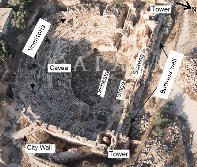 Figure 3
An aerial photograph of the excavated Beit-Ras/ Capitolias theater.
Main parts of the theater are indicated. The city wall serves as a buttress in front of the scaena walls and the towers with staircases. The city wall connected with the eastern stage gate and vomitoria gate.
Al-Tawalbeh et. al. (2020)
Photo taken on 1st October 2015 and photographed by Rebecca Elizabeth Banks (courtesy of Aerial Photographic Archive of Archaeology in the Middle East [APAAME], photo. APAAME_20151001_REB-0193. Creative Commons License CC BY-NC-ND 3.3. East—west length 57 m).
| Transliterated Name | Source | Name |
|---|---|---|
| Beit Ras | Arabic | بييت راس |
| Capitolias | Ancient Greek | Καπιτωλιάς |
| Bet Reisha | Aramaic |
- Fig. 2 Town Plan from
Al-Tawalbeh et. al. (2020)
 Figure 2
City plan of Capitolias/Beit-Ras (modified after Al-Shami, 2005).
Al-Tawalbeh et. al. (2020)
- Beit Ras/Capitolias in Google Earth
 Beit Ras/Capitolias
click on image to explore this site on a new tab in Google Earth
- Fig. 4 Major parts
of a Roman Theater from Al-Tawalbeh et. al. (2020)
 Figure 4
Major parts of a Roman theater. It is mostly the shape of Beit-Ras/Capitolias theater at the time of construction. Modified after Fayyad and Karasneh (2004), Karasneh and Fayyad (2005), and Sears (2006), and our field observation.
Al-Tawalbeh et. al. (2020) - Fig. 5 Archaeoseismic Plan
of the Capitolias Theater from Al-Tawalbeh et. al. (2020)
 Figure 5
Theater plan and the position of the observed damage features. Most of the locations' damage features are marked in the drawing.
Al-Tawalbeh et. al. (2020)
- Fig. 4 Major parts
of a Roman Theater from Al-Tawalbeh et. al. (2020)
Figure 4
Major parts of a Roman theater. It is mostly the shape of Beit-Ras/Capitolias theater at the time of construction. Modified after Fayyad and Karasneh (2004), Karasneh and Fayyad (2005), and Sears (2006), and our field observation.
Al-Tawalbeh et. al. (2020) - Fig. 5 Archaeoseismic Plan
of the Capitolias Theater from Al-Tawalbeh et. al. (2020)
Figure 5
Theater plan and the position of the observed damage features. Most of the locations' damage features are marked in the drawing.
Al-Tawalbeh et. al. (2020)
- Fig. 1 PCMA project
Excavation area map from Mlynarczyk (2017)
 Figure 1
Trenches excavated by the PCMA project (C) in relation to the Vaults area (A) and the Theater (B) (PCMA Beit Ras Project/R. Bieńkowski)
Mlynarczyk (2017) - Fig. 2 Map of area excavated
(sectors N, S, and SS) in 2015 and 2016 from Mlynarczyk (2017)
 Figure 2
Sector investigated by the PCMA Project: top, results of the electrical resistivity survey (2014); bottom, extent of trenches excavated in 2015–2016 in relation to the results of the electrical resistivity survey (PCMA Beit Ras Project/interpretation of survey results J. Ordutowski; plan J. Ordutowski [2014] and M. Burdajewicz [2015–2016])
Mlynarczyk (2017) - Fig. 6 Detailed plan
of Sector S excavation from Mlynarczyk (2017)
 Figure 5
Trench in Areas 1-S and 1-S(W). Key
- light grey — floors
- hatched — mosaic floor of the winery
(PCMA Beit Ras Project/drawing M Drzewiecki [2015], drawing and digitizing M Burdajewicz [2015-2016]
Mlynarczyk (2017)
- Fig. 1 PCMA project
Excavation area map from Mlynarczyk (2017)
Figure 1
Trenches excavated by the PCMA project (C) in relation to the Vaults area (A) and the Theater (B) (PCMA Beit Ras Project/R. Bieńkowski)
Mlynarczyk (2017) - Fig. 2 Map of area excavated
(sectors N, S, and SS) in 2015 and 2016 from Mlynarczyk (2017)
Figure 2
Sector investigated by the PCMA Project: top, results of the electrical resistivity survey (2014); bottom, extent of trenches excavated in 2015–2016 in relation to the results of the electrical resistivity survey (PCMA Beit Ras Project/interpretation of survey results J. Ordutowski; plan J. Ordutowski [2014] and M. Burdajewicz [2015–2016])
Mlynarczyk (2017) - Fig. 6 Detailed plan
of Sector S excavation from Mlynarczyk (2017)
Figure 5
Trench in Areas 1-S and 1-S(W). Key
- light grey — floors
- hatched — mosaic floor of the winery
(PCMA Beit Ras Project/drawing M Drzewiecki [2015], drawing and digitizing M Burdajewicz [2015-2016]
Mlynarczyk (2017)
- Fig. 9 Multiple phase
construction at eastern orchestra gate Al-Tawalbeh et. al. (2020)
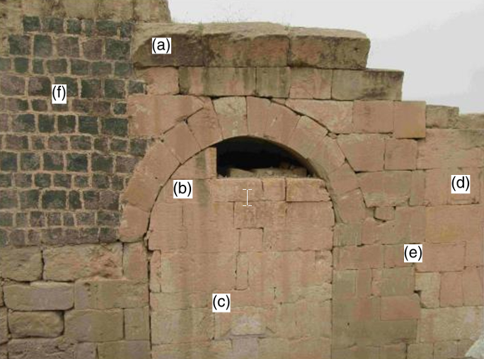
Figure 9
External view of the eastern orchestra gate leading from the outside into the aditus maximus.
- Above the gate arch, there are two rows of ashlars of the former vault of the ambulatorium.
- Upon the collapse of the passage, the gate was walled up, allowing access to the theater via a smaller stone door below (in the lower part).
- A carved inscription from A.D. 261 dates the walling up event.
- About a meter to the right, there is a different wall, made of chalky limestone of lighter color, and has irregular contact with the original wall.
- The wall suture clearly indicates that the lighter chalk wall was attached to the darker limestone wall later, as a repair structure.
- Repair on the left by basalt cubes was carried out after the wall with the inscription was built.
Al-Tawalbeh et. al. (2020) - Buttress Wall built
against tilting scaenae - photo by JW
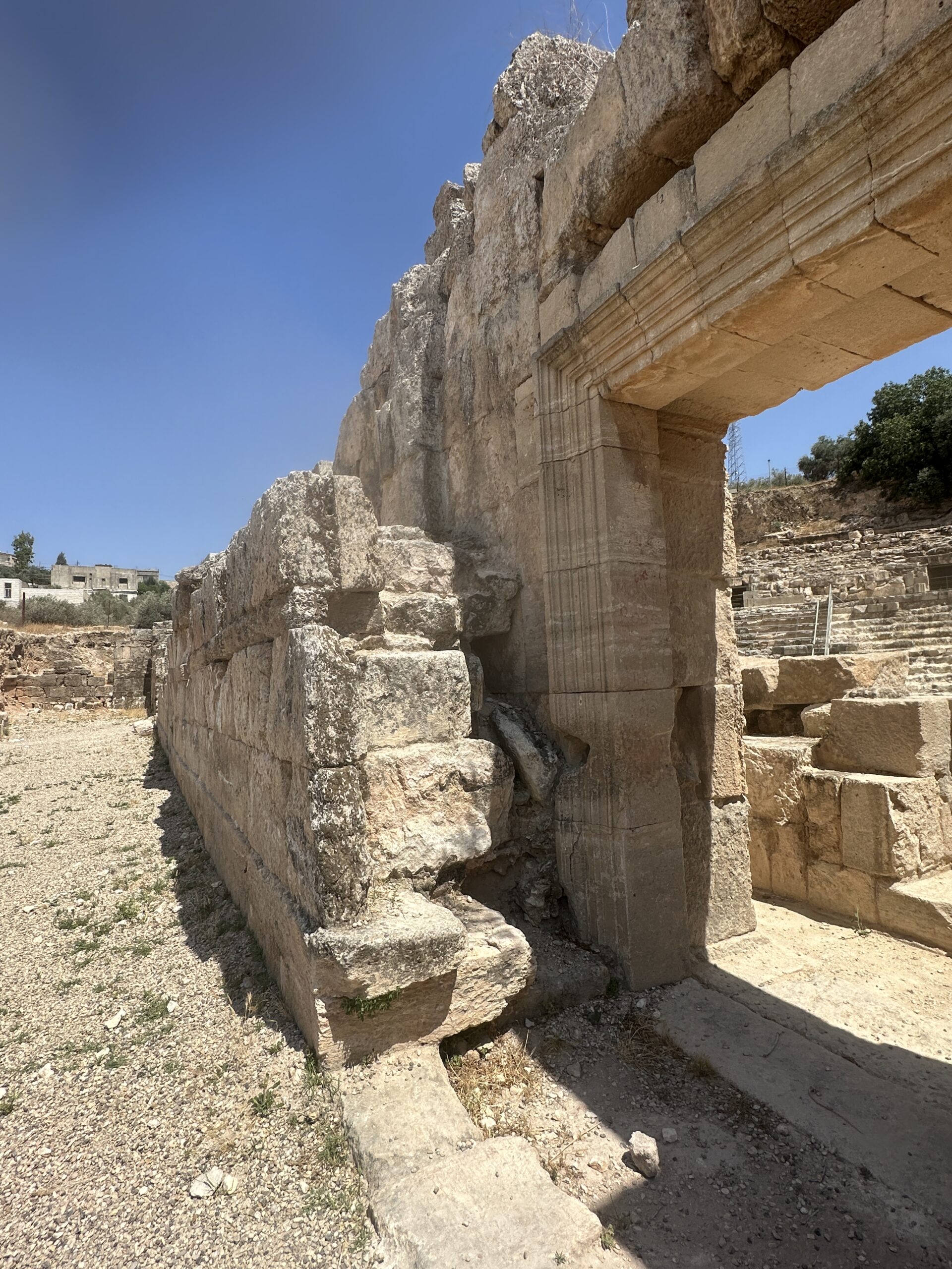 Buttress Wall built against tilting scaenae
Photo by Jefferson Williams - 24 June 2025 - Through-going crack
- photo by JW
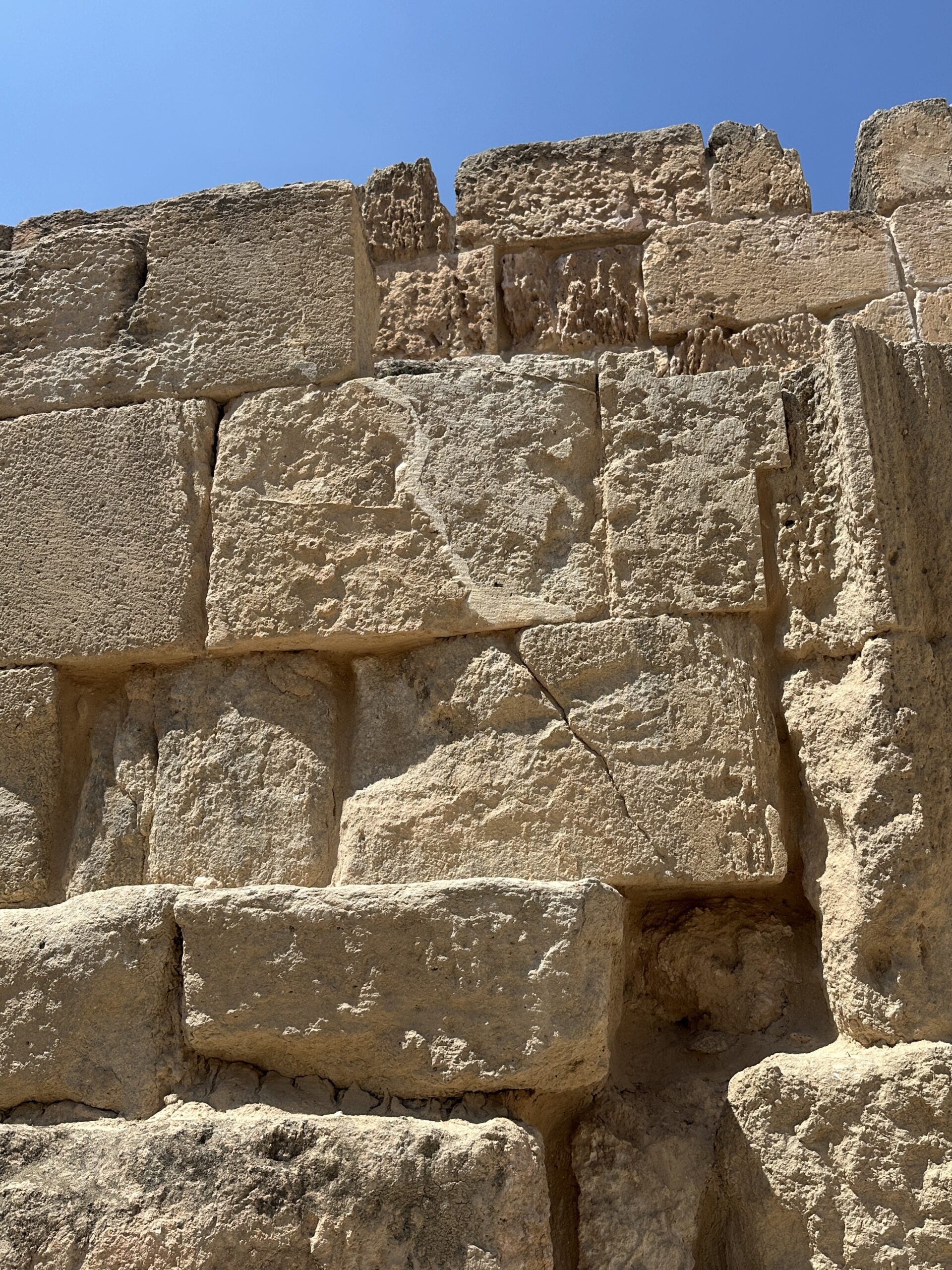 Through-going crack
Photo by Jefferson Williams - 24 June 2025 - Displaced archstones
- photo by JW
 Displaced archstones
Photo by Jefferson Williams - 24 June 2025
- Fig. 9 Multiple phase
construction at eastern orchestra gate Al-Tawalbeh et. al. (2020)
Figure 9
External view of the eastern orchestra gate leading from the outside into the aditus maximus.
- Above the gate arch, there are two rows of ashlars of the former vault of the ambulatorium.
- Upon the collapse of the passage, the gate was walled up, allowing access to the theater via a smaller stone door below (in the lower part).
- A carved inscription from A.D. 261 dates the walling up event.
- About a meter to the right, there is a different wall, made of chalky limestone of lighter color, and has irregular contact with the original wall.
- The wall suture clearly indicates that the lighter chalk wall was attached to the darker limestone wall later, as a repair structure.
- Repair on the left by basalt cubes was carried out after the wall with the inscription was built.
Al-Tawalbeh et. al. (2020) - Buttress Wall built
against tilting scaenae - photo by JW
Buttress Wall built against tilting scaenae
Photo by Jefferson Williams - 24 June 2025 - Through-going crack
- photo by JW
Through-going crack
Photo by Jefferson Williams - 24 June 2025 - Displaced archstones
- photo by JW
Displaced archstones
Photo by Jefferson Williams - 24 June 2025
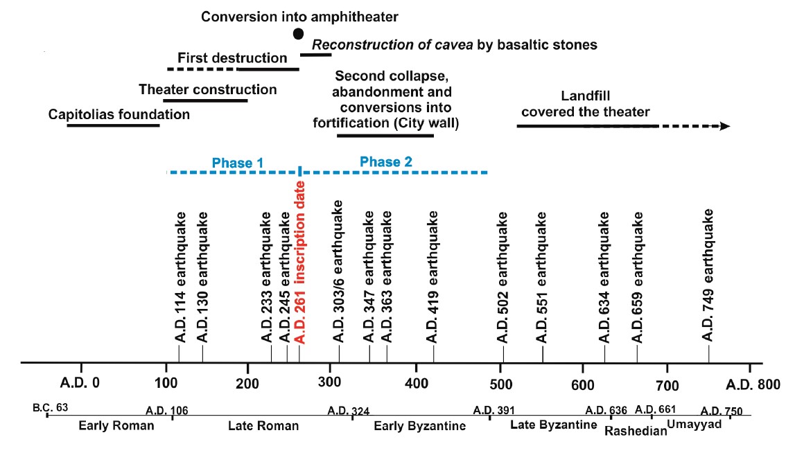 Figure 12
Timeline of the main phases, the two main phases of major destruction, which could be earthquake events and the candidate earthquakes that affected Beit-Ras and surrounding region. Historical chronology of Jordan from Early Roman to Umayyad modified after Stager et al. (2000).
JW: 233 and 245 earthquake dates are spurious. 130 CE earthquake is questionable and may be a duplicate of the Incense Road Earthquake (listed on the timeline as 114 CE). This is why this archaeoseismic evidence represents an earthquake not reported in the historical record but discovered by archaeoseismic means.
Al-Tawalbeh et. al. (2020)
| Phase | Comments |
|---|---|
| The foundation of Capitolias and the construction of the theater |
|
| 1st damage and construction |
|
| Conversion of use |
|
| 2nd collapse and abandonment |
|
| 2nd restoration phase |
|
| The landfill |
|

- from Chat GPT 4o, 25 June 2025
- from Al-Tawalbeh et al. (2020:12–13, fig. 9)
- Fig. 9 Multiple phase
construction at eastern orchestra gate Al-Tawalbeh et. al. (2020)
Figure 9
External view of the eastern orchestra gate leading from the outside into the aditus maximus.
- Above the gate arch, there are two rows of ashlars of the former vault of the ambulatorium.
- Upon the collapse of the passage, the gate was walled up, allowing access to the theater via a smaller stone door below (in the lower part).
- A carved inscription from A.D. 261 dates the walling up event.
- About a meter to the right, there is a different wall, made of chalky limestone of lighter color, and has irregular contact with the original wall.
- The wall suture clearly indicates that the lighter chalk wall was attached to the darker limestone wall later, as a repair structure.
- Repair on the left by basalt cubes was carried out after the wall with the inscription was built.
Al-Tawalbeh et. al. (2020)
The eastern aditus maximus at the Beit-Ras/ Capitolias theatre preserves stratigraphic and structural evidence for multiple damage and repair phases likely related to earthquake activity. The original wall forming the gate passage was constructed from high-quality, dark phosphatic ashlars. This wall was later damaged, most likely by seismic shaking, prompting a reconstruction phase using lighter-colored chalk limestone blocks. An irregular joint between the dark and light stonework marks this repair boundary.
In a subsequent phase, three limestone ashlars were inserted horizontally to block and support the collapsed arch of the gate. These were positioned beneath the keystone and the springers of the former arch, effectively buttressing the weakened structure. This intervention likely postdates the initial damage and represents an effort to stabilize the gateway after structural failure, possibly caused by an earthquake.
At a later point, a basalt cube wall was constructed in the corridor behind an inscription-bearing wall. Because the inscription is dated to 261 CE, this later repair must have occurred after that date, indicating another phase of minor seismic damage and response. The differing materials, construction styles, and stratigraphic relationships reveal a sequence of damage, reconstruction, and localized stabilization associated with at least two distinct earthquakes—one prior to 261 CE and another after.
- Fig. 1 PCMA project
Excavation area map from Mlynarczyk (2017)
Figure 1
Trenches excavated by the PCMA project (C) in relation to the Vaults area (A) and the Theater (B) (PCMA Beit Ras Project/R. Bieńkowski)
Mlynarczyk (2017) - Fig. 2 Map of area excavated
(sectors N, S, and SS) in 2015 and 2016 from Mlynarczyk (2017)
Figure 2
Sector investigated by the PCMA Project: top, results of the electrical resistivity survey (2014); bottom, extent of trenches excavated in 2015–2016 in relation to the results of the electrical resistivity survey (PCMA Beit Ras Project/interpretation of survey results J. Ordutowski; plan J. Ordutowski [2014] and M. Burdajewicz [2015–2016])
Mlynarczyk (2017) - Fig. 6 Detailed plan
of Sector S excavation from Mlynarczyk (2017)
Figure 5
Trench in Areas 1-S and 1-S(W). Key
- light grey — floors
- hatched — mosaic floor of the winery
(PCMA Beit Ras Project/drawing M Drzewiecki [2015], drawing and digitizing M Burdajewicz [2015-2016]
Mlynarczyk (2017) - Fig. 10 Tumbled Blocks
from Mlynarczyk (2017)
 Figure 10
Blocks tumbled from wall W K with part of floor F III above, view facing east (PCM/1 Belt Ras Project/photo J. Mlynarczyk)
Mlynarczyk (2017)
- Fig. 1 PCMA project
Excavation area map from Mlynarczyk (2017)
Figure 1
Trenches excavated by the PCMA project (C) in relation to the Vaults area (A) and the Theater (B) (PCMA Beit Ras Project/R. Bieńkowski)
Mlynarczyk (2017) - Fig. 2 Map of area excavated
(sectors N, S, and SS) in 2015 and 2016 from Mlynarczyk (2017)
Figure 2
Sector investigated by the PCMA Project: top, results of the electrical resistivity survey (2014); bottom, extent of trenches excavated in 2015–2016 in relation to the results of the electrical resistivity survey (PCMA Beit Ras Project/interpretation of survey results J. Ordutowski; plan J. Ordutowski [2014] and M. Burdajewicz [2015–2016])
Mlynarczyk (2017) - Fig. 6 Detailed plan
of Sector S excavation from Mlynarczyk (2017)
Figure 5
Trench in Areas 1-S and 1-S(W). Key
- light grey — floors
- hatched — mosaic floor of the winery
(PCMA Beit Ras Project/drawing M Drzewiecki [2015], drawing and digitizing M Burdajewicz [2015-2016]
Mlynarczyk (2017) - Fig. 10 Tumbled Blocks
from Mlynarczyk (2017)
Figure 10
Blocks tumbled from wall W K with part of floor F III above, view facing east (PCM/1 Belt Ras Project/photo J. Mlynarczyk)
Mlynarczyk (2017)
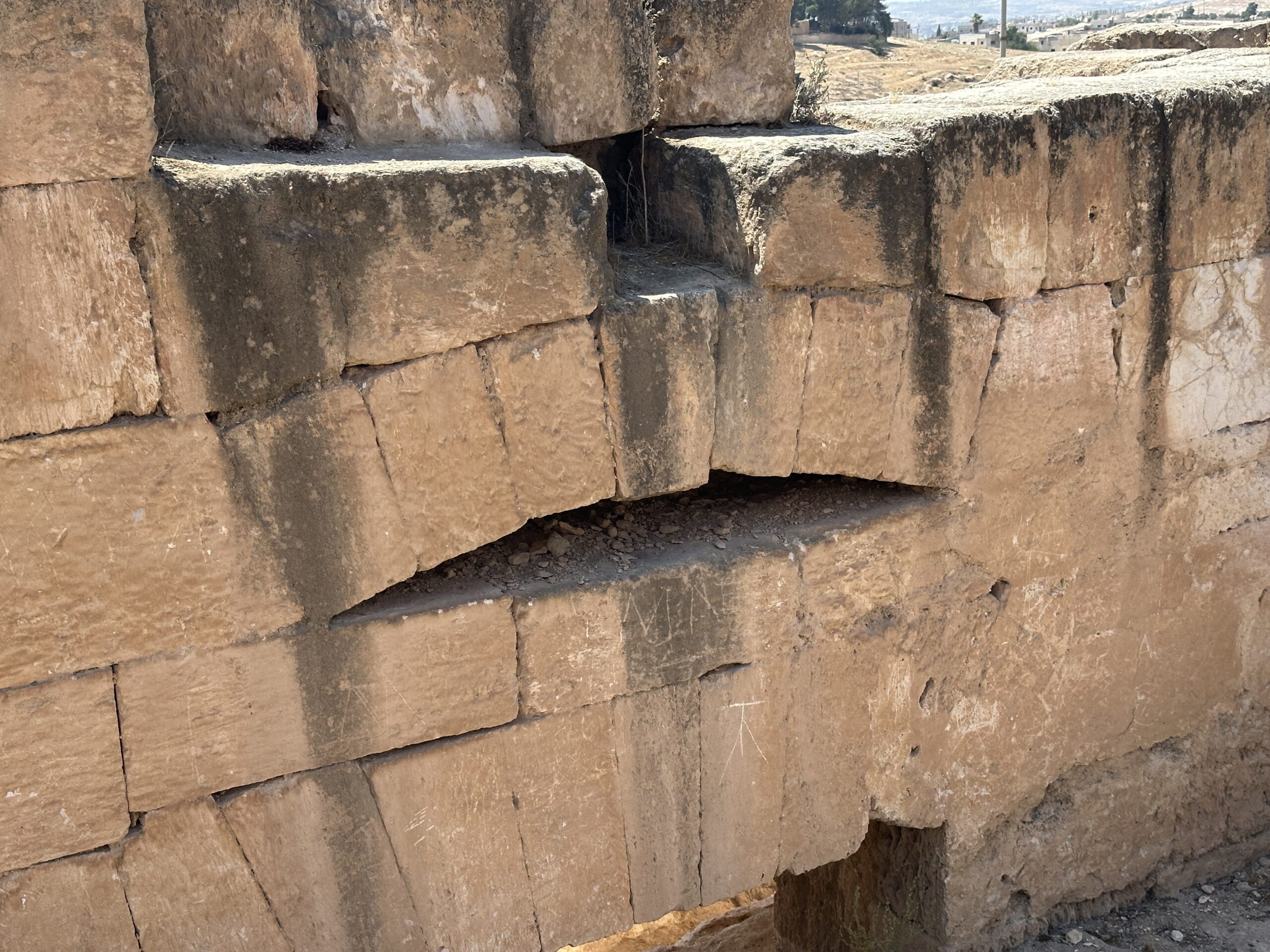
- Fig. 9f - Eastern
orchestra gate -
from Al-Tawalbeh et. al. (2020)
 Figure 9
External view of the eastern orchestra gate leading from the outside into the aditus maximus.
- Above the gate arch, there are two rows of ashlars of the former vault of the ambulatorium.
- Upon the collapse of the passage, the gate was walled up, allowing access to the theater via a smaller stone door below (in the lower part).
- A carved inscription from A.D. 261 dates the walling up event.
- About a meter to the right, there is a different wall, made of chalky limestone of lighter color, and has irregular contact with the original wall.
- The wall suture clearly indicates that the lighter chalk wall was attached to the darker limestone wall later, as a repair structure.
- Repair on the left by basalt cubes was carried out after the wall with the inscription was built.
Al-Tawalbeh et. al. (2020)
Al-Tawalbeh et al. (2020:14) discussed archaeoseismic evidence for later post-abandonment earthquakes at the Beit Ras theatre. They wrote that “filling up the cavea and orchestra of the theater happened parallel with the construction of the enclosing wall that essentially put all of the remaining building underground.”
They noted that “underground facilities are significantly less vulnerable to seismic excitation than above-ground buildings” and that because “each wall and arch are supported by embedding sediment (dump in Beit-Ras), the observed deformations of the excavated theater mostly cannot develop unless unsupported.” As a result, they concluded that “evidence of damage due to any subsequent events, such as A.D. 551, 634, 659, and 749, cannot be observed, because the possibility of collapse of buried structures is not plausible.”
They did, however, state that “potential collapse of other above-ground structures within the site of Beit-Ras cannot be ignored, such as the upper elements of the theater's structures, which were still exposed after the filling of the theater with debris.” They reported “several observations indicated that many collapsed elements of the upper parts of the theater were mixed with the debris,” citing documentation in the excavation reports of Al-Shami (2003, 2004).
They also noted that Mlynarczyk (2017) saw evidence for the 749 CE earthquake in Beit Ras where she observed a “concentration of collapsed ashlars" dated to around that time based on pottery excavated from two trenches west of the theater structure.
Regarding the eastern orchestra gate, Al-Tawalbeh et al. (2020:6) wrote: “The basalt masonry in the upper left (Fig. 9f - see above) suggests a later local collapse and repair phase, where the basalt courses are overlaying the marly-chalky limestone to the left of the walled arched eastern gate.”
| Effect | Location | Image(s) | Description |
|---|---|---|---|
| perimeter corridor, ambulacrum, and scaenae damaged beyond repair | perimeter corridor, ambulacrum,
and the scaenae
Figure 4 Major parts of a Roman theater. It is mostly the shape of Beit-Ras/Capitolias theater at the time of construction. Modified after Fayyad and Karasneh (2004), Karasneh and Fayyad (2005), and Sears (2006), and our field observation. Al-Tawalbeh et. al. (2020) |
Figure 5 Theater plan and the position of the observed damage features. Most of the locations' damage features are marked in the drawing. Al-Tawalbeh et. al. (2020) |
|
| destruction of the annular passageway (ambulatorium) | ambulatorium
Figure 4 Major parts of a Roman theater. It is mostly the shape of Beit-Ras/Capitolias theater at the time of construction. Modified after Fayyad and Karasneh (2004), Karasneh and Fayyad (2005), and Sears (2006), and our field observation. Al-Tawalbeh et. al. (2020) |
Figure 5 Theater plan and the position of the observed damage features. Most of the locations' damage features are marked in the drawing. Al-Tawalbeh et. al. (2020) |
|
| Collapsed Staircases | Staircases
Figure 4 Major parts of a Roman theater. It is mostly the shape of Beit-Ras/Capitolias theater at the time of construction. Modified after Fayyad and Karasneh (2004), Karasneh and Fayyad (2005), and Sears (2006), and our field observation. Al-Tawalbeh et. al. (2020) |
Figure 5 Theater plan and the position of the observed damage features. Most of the locations' damage features are marked in the drawing. Al-Tawalbeh et. al. (2020) |
|
| Effect | Location | Image(s) | Description |
|---|---|---|---|
| tilting of the rebuilt scaenae wall | scaenae wall
Figure 4 Major parts of a Roman theater. It is mostly the shape of Beit-Ras/Capitolias theater at the time of construction. Modified after Fayyad and Karasneh (2004), Karasneh and Fayyad (2005), and Sears (2006), and our field observation. Al-Tawalbeh et. al. (2020) |
Fig. 8a
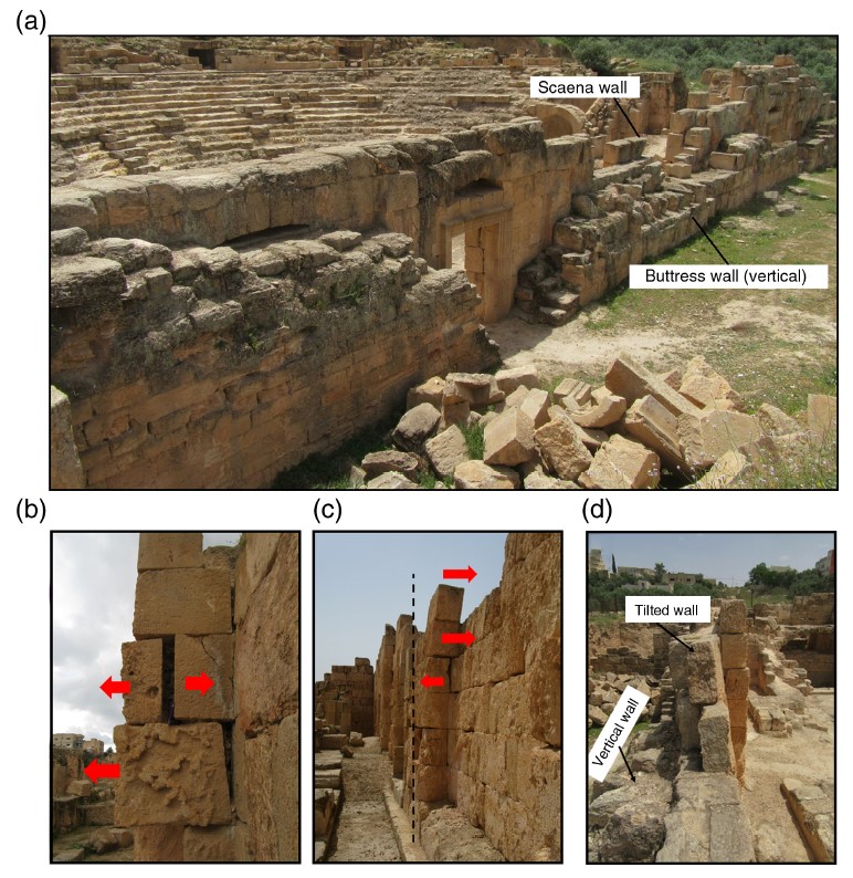 Figure 8
Deformation of scaena:
Al-Tawalbeh et. al. (2020)
Figure 5Theater plan and the position of the observed damage features. Most of the locations' damage features are marked in the drawing. Al-Tawalbeh et. al. (2020) |
|
collapse of the upper two-thirdsof scaenae wall |
scaenae wall
Figure 4 Major parts of a Roman theater. It is mostly the shape of Beit-Ras/Capitolias theater at the time of construction. Modified after Fayyad and Karasneh (2004), Karasneh and Fayyad (2005), and Sears (2006), and our field observation. Al-Tawalbeh et. al. (2020) |
Figure 5 Theater plan and the position of the observed damage features. Most of the locations' damage features are marked in the drawing. Al-Tawalbeh et. al. (2020) |
|
| vaulted corridors totally demolished | vaulted corridors
Figure 4 Major parts of a Roman theater. It is mostly the shape of Beit-Ras/Capitolias theater at the time of construction. Modified after Fayyad and Karasneh (2004), Karasneh and Fayyad (2005), and Sears (2006), and our field observation. Al-Tawalbeh et. al. (2020) |
Figure 5 Theater plan and the position of the observed damage features. Most of the locations' damage features are marked in the drawing. Al-Tawalbeh et. al. (2020) |
|
| Shifted blocks and extensional gaps |
Figure 4 Major parts of a Roman theater. It is mostly the shape of Beit-Ras/Capitolias theater at the time of construction. Modified after Fayyad and Karasneh (2004), Karasneh and Fayyad (2005), and Sears (2006), and our field observation. Al-Tawalbeh et. al. (2020) |
Fig. 8 b&c
Figure 8 Deformation of scaena:
Al-Tawalbeh et. al. (2020)
Figure 5Theater plan and the position of the observed damage features. Most of the locations' damage features are marked in the drawing. Al-Tawalbeh et. al. (2020) |
| Effect | Location | Image(s) | Description |
|---|---|---|---|
| Tumble from a collapsed wall | Tumble originated from Wall WV and is located below Floor F III
Figure 5 Trench in Areas 1-S and 1-S(W). Key
(PCMA Beit Ras Project/drawing M Drzewiecki [2015], drawing and digitizing M Burdajewicz [2015-2016] Mlynarczyk (2017) |
Figure 10 Blocks tumbled from wall W K with part of floor F III above, view facing east (PCM/1 Belt Ras Project/photo J. Mlynarczyk) Mlynarczyk (2017) |
|
| Tumble from a collapsed wall | space between [Walls] W II and W III in the northeastern part of the trench
Figure 5 Trench in Areas 1-S and 1-S(W). Key
(PCMA Beit Ras Project/drawing M Drzewiecki [2015], drawing and digitizing M Burdajewicz [2015-2016] Mlynarczyk (2017) |
|
|
| Wall Destruction (collapsed walls) | northern defensive wall
Figure 2 City plan of Capitolias/Beit-Ras (modified after Al-Shami, 2005). Al-Tawalbeh et. al. (2020) |
|
| Damage Type | Event | Plan(s) | Figure | Comments |
|---|---|---|---|---|
| Displaced Arches | ?4 |
Figure 4 Major parts of a Roman theater. It is mostly the shape of Beit-Ras/Capitolias theater at the time of construction. Modified after Fayyad and Karasneh (2004), Karasneh and Fayyad (2005), and Sears (2006), and our field observation. Al-Tawalbeh et. al. (2020)
Figure 5Theater plan and the position of the observed damage features. Most of the locations' damage features are marked in the drawing. Al-Tawalbeh et. al. (2020) |
6a
 Figure 6a
Damage features within displaced arches: dropped blocks of the flat arch, east door in scaena Al-Tawalbeh et. al. (2020) |
The flat arches are seen as the lintel arches above the stage gates (Fig. 6a)(Al-Tawalbeh et. al., 2020:4)1 |
| Displaced Arches | ?4 |
Figure 4 Major parts of a Roman theater. It is mostly the shape of Beit-Ras/Capitolias theater at the time of construction. Modified after Fayyad and Karasneh (2004), Karasneh and Fayyad (2005), and Sears (2006), and our field observation. Al-Tawalbeh et. al. (2020)
Figure 5Theater plan and the position of the observed damage features. Most of the locations' damage features are marked in the drawing. Al-Tawalbeh et. al. (2020) |
6b
 Figure 6b
dropped blocks of the flat arch of the eastern stage gate (versura) Al-Tawalbeh et. al. (2020) |
The eastern stage gate (versurae), trending north-south, has a flat arch and a stress-releasing segmental arch above, where two stones of the flat arch dropped down almost 3 cm (Fig. 6b)(Al-Tawalbeh et. al., 2020:4)1 |
| Displaced Arches | ?4 |
Figure 4 Major parts of a Roman theater. It is mostly the shape of Beit-Ras/Capitolias theater at the time of construction. Modified after Fayyad and Karasneh (2004), Karasneh and Fayyad (2005), and Sears (2006), and our field observation. Al-Tawalbeh et. al. (2020)
Figure 5Theater plan and the position of the observed damage features. Most of the locations' damage features are marked in the drawing. Al-Tawalbeh et. al. (2020) |
6c
 Figure 6c
dropped blocks of the flat arch of vomitorium, small spaces between the stones formed due to the ground shaking Al-Tawalbeh et. al. (2020) |
The flat arches of most vomitoria to the cavea also are dropped down (Fig. 6c)(Al-Tawalbeh et. al., 2020:4)1 |
| Displaced Arches | ?4 |
Figure 4 Major parts of a Roman theater. It is mostly the shape of Beit-Ras/Capitolias theater at the time of construction. Modified after Fayyad and Karasneh (2004), Karasneh and Fayyad (2005), and Sears (2006), and our field observation. Al-Tawalbeh et. al. (2020)
Figure 5Theater plan and the position of the observed damage features. Most of the locations' damage features are marked in the drawing. Al-Tawalbeh et. al. (2020) |
6d
 Figure 6d
dropped keystone of the stress-releasing segmental arch above eastern stage gate (versura) Al-Tawalbeh et. al. (2020) |
The keystone of the segmental arch above is also dropped down —4 cm. (Fig. 6d)(Al-Tawalbeh et. al., 2020:4)1 |
| Chipped corners and edges of ashlars | ?5 |
Figure 4 Major parts of a Roman theater. It is mostly the shape of Beit-Ras/Capitolias theater at the time of construction. Modified after Fayyad and Karasneh (2004), Karasneh and Fayyad (2005), and Sears (2006), and our field observation. Al-Tawalbeh et. al. (2020)
Figure 5Theater plan and the position of the observed damage features. Most of the locations' damage features are marked in the drawing. Al-Tawalbeh et. al. (2020) |
7
 Figure 7
Chipped corners and edges of stones: (a,b) back part of the western orchestra gate (c) front part of the western orchestra gate (d) some parts of the eastern orchestra gate. The edges of blocks cracked and spalled off. Al-Tawalbeh et. al. (2020) |
|
| Tilted and Collapsed Walls | after 260/261 CE |
Figure 4 Major parts of a Roman theater. It is mostly the shape of Beit-Ras/Capitolias theater at the time of construction. Modified after Fayyad and Karasneh (2004), Karasneh and Fayyad (2005), and Sears (2006), and our field observation. Al-Tawalbeh et. al. (2020)
Figure 5Theater plan and the position of the observed damage features. Most of the locations' damage features are marked in the drawing. Al-Tawalbeh et. al. (2020) |
8
Figure 8 Deformation of scaena:
Al-Tawalbeh et. al. (2020) |
Figure 8 shows a deviation of the scaenae wall from the vertical toward the north by 8°.(Al-Tawalbeh et. al., 2020:5) |
| Tilted and Collapsed Walls | after 260/261 CE |
Figure 4 Major parts of a Roman theater. It is mostly the shape of Beit-Ras/Capitolias theater at the time of construction. Modified after Fayyad and Karasneh (2004), Karasneh and Fayyad (2005), and Sears (2006), and our field observation. Al-Tawalbeh et. al. (2020)
Figure 5Theater plan and the position of the observed damage features. Most of the locations' damage features are marked in the drawing. Al-Tawalbeh et. al. (2020) |
5
Figure 5 Theater plan and the position of the observed damage features. Most of the locations' damage features are marked in the drawing. Al-Tawalbeh et. al. (2020) 8
Figure 8Deformation of scaena:
Al-Tawalbeh et. al. (2020) |
a vertical buttress wall (portion of the city wall) was erected behind the tilted scaenae wall (Figs. 5 and 8).(Al-Tawalbeh et. al., 2020:5)3 |
| Shifted blocks and extensional gaps | after 260/261 CE |
Figure 4 Major parts of a Roman theater. It is mostly the shape of Beit-Ras/Capitolias theater at the time of construction. Modified after Fayyad and Karasneh (2004), Karasneh and Fayyad (2005), and Sears (2006), and our field observation. Al-Tawalbeh et. al. (2020)
Figure 5Theater plan and the position of the observed damage features. Most of the locations' damage features are marked in the drawing. Al-Tawalbeh et. al. (2020) |
8 b&c
Figure 8 Deformation of scaena:
Al-Tawalbeh et. al. (2020) |
A number of out-of-plane extruded and shifted blocks are observed and developed across single or multiple masonry courses (Fig. 8b,c). Such features are typically associated with intervening gaps produced due to shaking directed at high angle to the wall (Kazmer, 2014), suggesting an intensity range of IX-XII (Rodríguez-Pascua et al, 2013:221-224).(Al-Tawalbeh et. al., 2020:5) |
| Collapsed Staircases | before 260/261 CE and after 260/261 CE |
Figure 4 Major parts of a Roman theater. It is mostly the shape of Beit-Ras/Capitolias theater at the time of construction. Modified after Fayyad and Karasneh (2004), Karasneh and Fayyad (2005), and Sears (2006), and our field observation. Al-Tawalbeh et. al. (2020)
Figure 5Theater plan and the position of the observed damage features. Most of the locations' damage features are marked in the drawing. Al-Tawalbeh et. al. (2020) |
5
Figure 5 Theater plan and the position of the observed damage features. Most of the locations' damage features are marked in the drawing. Al-Tawalbeh et. al. (2020) |
Al-Tawalbeh et. al. (2020:6) notes that the staircases were rebuilt after the first damaging event (before 260/261 CE); presumably with locally derived marly-chalky limestone associated with the rebuild rather than the better quality imported phosphatic limestone associated with original construction. This would indicate that the collapsed staircases presently observed collapsed a second time after another (not necessarily the 2nd) damaging event - location of the collapsed staircases is shown in the bottom left and bottom right of Figure 5. |
1 Masonry arches are common above openings in walls, spanning wall openings by diverting vertical loads from above to compressive stress
laterally (Dym and Williams, 2010). Dropped arches in a masonry building indicate an
EAE having an earthquake
intensity of VII or higher (Rodríguez-Pascua et al, 2013:221-224)
.
(Al-Tawalbeh et. al., 2020:5).
2 Chipping of stone corners can occur during ground motion at any structure, especially the ones with well-cut and sharp-edged blocks.
This is because a large pressure is applied more on the corners than other parts
(Marco, 2008).
(Al-Tawalbeh et. al., 2020:5)
3 The normal elevation of the scaenae
is presumed to be the same as the colonnade on top of the
cavea or even higher
(i.e., almost 13 m). Today, only the lower 5.2 m of the
scaenae is preserved. Tilted and collapsed archaeological walls
suggested an EAE seismic intensity range of IX and higher
(Rodríguez-Pascua et al, 2013:221-224).
(Al-Tawalbeh et. al., 2020:5)
4
Arches oriented ~N-S are shown in Figure 6 b&d while arches oriented ~E-W are shown in Figure 6 a&c. The two orientations would likely reflect arch
damage from two separate events since as noted by
Al-Tawalbeh et. al., (2020:10), usually an arch stone drop occurs when ground motion is parallel to the trend of the arches
(
Hinzen et al., 2016;
Martin-Gonzalez, 2018) or if it is ±45° to their strike
(
Rodriguez-Pascua et al., 2011).
Since
Al-Tawalbeh et. al., (2020:8) note that the severely damaged
vomitoria arches
were left unrepaired
after the second earthquake event, this might suggest
that these E-W trending arches were damaged in the second event and the ~N-S trending arches were damaged in the first event.
However, Al-Tawalbeh (personal communication, 2021) cautioned that it was not possible to date the arch damage noting, for example, that some arch damage could
have occurred after the building of the buttress wall and not be attributable to either the mid 3rd century CE earthquake or the 3rd-5th century CE earthquake.
Thus, while the varied orientations of the arches do indicate damage from more than one event, it is not possible to assign a date to that damage at this time.
It should also be noted that dropped keystones are also present in ~NW and ~NNW trending arches of the
vomitoria which can be observed in the Plan of the Capitolias Theater with damage locations
(Fig. 5 of
Al-Tawalbeh et al, 2020). This might suggest arch damage in more than two events.
- Plan of the Capitolias Theater with damage locations
from Al-Tawalbeh et. al. (2020)
Figure 5
Theater plan and the position of the observed damage features. Most of the locations' damage features are marked in the drawing.
Al-Tawalbeh et. al. (2020)
a subsequent earthquake cracked the ashlars of the gate, causing stone spalling and breaking off.where the gate is the eastern aditus maximus where the dedicatory inscription is located. The
subsequentearthquake is not dated. It is entirely possible however that the spalling occurred during the pre 260/261 CE earthquake.
- Modified by JW from Fig. 5 of Al-Tawalbeh et. al. (2020)
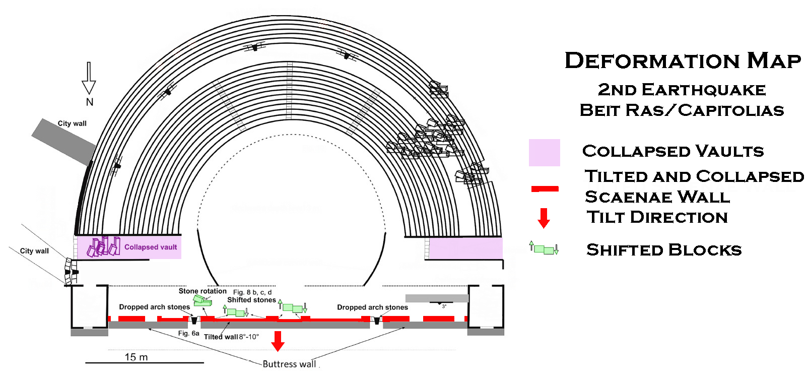
 Deformation Map
Modified by JW from Fig. 5 of Al-Tawalbeh et. al. (2020)
- Modified by JW from Fig. 5 of Al-Tawalbeh et. al. (2020)
 Deformation Map
Modified by JW from Fig. 5 of Al-Tawalbeh et. al. (2020)
- Modified by JW from Fig. 5 of Mlynarczyk (2017)
 Deformation Map
Modified by JW from Fig. 5 of Mlynarczyk (2017)
-
Earthquake Archeological Effects chart
of Rodríguez-Pascua et al (2013: 221-224)
 Earthquake Archeological Effects (EAE)
Rodríguez-Pascua et al (2013: 221-224)
| Effect | Location | Image(s) | Description | Intensity |
|---|---|---|---|---|
| perimeter corridor, ambulacrum, and scaenae damaged beyond repair - Collapsed Walls and Vaults | perimeter corridor, ambulacrum,
and the scaenae
Figure 4 Major parts of a Roman theater. It is mostly the shape of Beit-Ras/Capitolias theater at the time of construction. Modified after Fayyad and Karasneh (2004), Karasneh and Fayyad (2005), and Sears (2006), and our field observation. Al-Tawalbeh et. al. (2020) |
Figure 5 Theater plan and the position of the observed damage features. Most of the locations' damage features are marked in the drawing. Al-Tawalbeh et. al. (2020) |
|
VIII + |
| destruction of the annular passageway (ambulatorium) - Collapsed Walls | ambulatorium
Figure 4 Major parts of a Roman theater. It is mostly the shape of Beit-Ras/Capitolias theater at the time of construction. Modified after Fayyad and Karasneh (2004), Karasneh and Fayyad (2005), and Sears (2006), and our field observation. Al-Tawalbeh et. al. (2020) |
Figure 5 Theater plan and the position of the observed damage features. Most of the locations' damage features are marked in the drawing. Al-Tawalbeh et. al. (2020) |
|
VIII + |
| Collapsed Staircases - Collapsed Walls | Staircases
Figure 4 Major parts of a Roman theater. It is mostly the shape of Beit-Ras/Capitolias theater at the time of construction. Modified after Fayyad and Karasneh (2004), Karasneh and Fayyad (2005), and Sears (2006), and our field observation. Al-Tawalbeh et. al. (2020) |
Figure 5 Theater plan and the position of the observed damage features. Most of the locations' damage features are marked in the drawing. Al-Tawalbeh et. al. (2020) |
|
VIII + |
-
Earthquake Archeological Effects chart
of Rodríguez-Pascua et al (2013: 221-224)
Earthquake Archeological Effects (EAE)
Rodríguez-Pascua et al (2013: 221-224)
| Effect | Location | Image(s) | Description | Intensity |
|---|---|---|---|---|
| tilting of the rebuilt scaenae wall | scaenae wall
Figure 4 Major parts of a Roman theater. It is mostly the shape of Beit-Ras/Capitolias theater at the time of construction. Modified after Fayyad and Karasneh (2004), Karasneh and Fayyad (2005), and Sears (2006), and our field observation. Al-Tawalbeh et. al. (2020) |
Fig. 8a
Figure 8 Deformation of scaena:
Al-Tawalbeh et. al. (2020)
Figure 5Theater plan and the position of the observed damage features. Most of the locations' damage features are marked in the drawing. Al-Tawalbeh et. al. (2020) |
|
VI+ |
collapse of the upper two-thirdsof scaenae wall |
scaenae wall
Figure 4 Major parts of a Roman theater. It is mostly the shape of Beit-Ras/Capitolias theater at the time of construction. Modified after Fayyad and Karasneh (2004), Karasneh and Fayyad (2005), and Sears (2006), and our field observation. Al-Tawalbeh et. al. (2020) |
Figure 5 Theater plan and the position of the observed damage features. Most of the locations' damage features are marked in the drawing. Al-Tawalbeh et. al. (2020) |
|
VIII+ |
| Collapsed Vaults - vaulted corridors totally demolished | vaulted corridors
Figure 4 Major parts of a Roman theater. It is mostly the shape of Beit-Ras/Capitolias theater at the time of construction. Modified after Fayyad and Karasneh (2004), Karasneh and Fayyad (2005), and Sears (2006), and our field observation. Al-Tawalbeh et. al. (2020) |
Figure 5 Theater plan and the position of the observed damage features. Most of the locations' damage features are marked in the drawing. Al-Tawalbeh et. al. (2020) |
|
VIII+ |
| Displaced masonry blocks - Shifted blocks and extensional gaps |
Figure 4 Major parts of a Roman theater. It is mostly the shape of Beit-Ras/Capitolias theater at the time of construction. Modified after Fayyad and Karasneh (2004), Karasneh and Fayyad (2005), and Sears (2006), and our field observation. Al-Tawalbeh et. al. (2020) |
Fig. 8 b&c
Figure 8 Deformation of scaena:
Al-Tawalbeh et. al. (2020)
Figure 5Theater plan and the position of the observed damage features. Most of the locations' damage features are marked in the drawing. Al-Tawalbeh et. al. (2020) |
VIII+ |
-
Earthquake Archeological Effects chart
of Rodríguez-Pascua et al (2013: 221-224)
Earthquake Archeological Effects (EAE)
Rodríguez-Pascua et al (2013: 221-224)
| Effect | Location | Image(s) | Description | Intensity |
|---|---|---|---|---|
| Tumble from a collapsed wall | Tumble originated from Wall WV and is located below Floor F III
Figure 5 Trench in Areas 1-S and 1-S(W). Key
(PCMA Beit Ras Project/drawing M Drzewiecki [2015], drawing and digitizing M Burdajewicz [2015-2016] Mlynarczyk (2017) |
Figure 10 Blocks tumbled from wall W K with part of floor F III above, view facing east (PCM/1 Belt Ras Project/photo J. Mlynarczyk) Mlynarczyk (2017) |
|
VIII+ |
| Tumble from a collapsed wall | space between [Walls] W II and W III in the northeastern part of the trench
Figure 5 Trench in Areas 1-S and 1-S(W). Key
(PCMA Beit Ras Project/drawing M Drzewiecki [2015], drawing and digitizing M Burdajewicz [2015-2016] Mlynarczyk (2017) |
|
VIII+ | |
| Wall Destruction (collapsed walls) | northern defensive wall
Figure 2 City plan of Capitolias/Beit-Ras (modified after Al-Shami, 2005). Al-Tawalbeh et. al. (2020) |
|
VIII+ |