Open this page in a new tab

Arbel

Synagogue Ruins at Arbel 
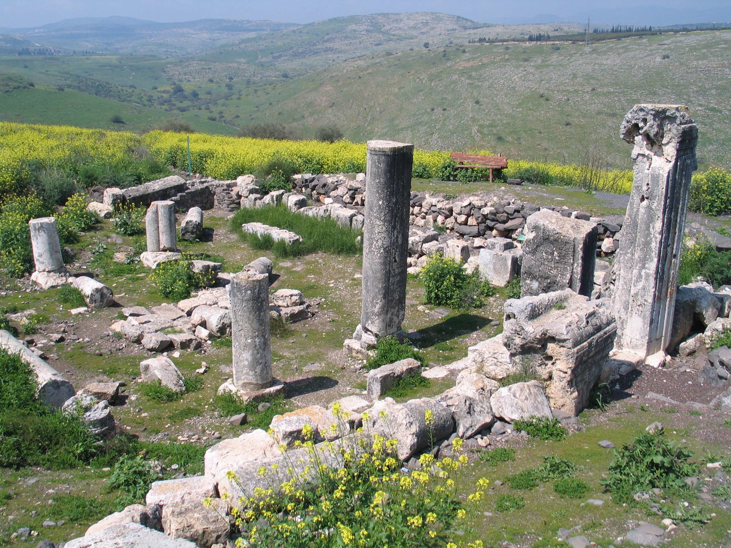
Remains of the Ancient Synagogue at Arbel

Source: Burkvoed - Wikipedia


Names

Transliterated Name Language Name
Arbel Hebrew אַרְבֵּל
Hittin Arabic حطّين
Hattin Arabic حَـطِّـيْـن
Introduction
Introduction

Arbel is located in the Galilee ~8 km. from Tiberias. The site has a long history of habitation and is mentioned in the Hebrew Bible as Beth-Arbel in Hosea 10:14. After the crusader period, settlement appears to have declined (Ilan and Izdarechet in Stern et al, 1993). Arbel contains the remains of an ancient synagogue that may have been damaged or destroyed in the 6th century CE and again in the 8th century CE by one of the Sabbatical Year Quakes.

Identification and History

The ancient settlement of Arbel is located in the eastern Lower Galilee, on the summit of Mount Nittai, to the north of Nahal Arbel (map reference 1955.2467). The site is mentioned in the Bible only once, in the prophecy of Hosea (10: 14), as Beth-Arbel. Arbel was the residence of Nittai of Arbela, the colleague of Joshua ben Perahiah-the second "pair" of early Torah scholars mentioned in the Mishnah(Avot 1, 6-7; Hag. 2, 2)during the Second Temple period. During Bacchides' campaign against Judea, fortified caves called "Mesaloth in Arbela" were captured (1 Mace. 9:2), and when Herod fought the Galilean Zealots, the Hasmonean loyalists fortified themselves in Arbela (Josephus, Antiq. XIV, 415-430; War I, 305-313). References to rabbis who visited Arbel or studied here attest to there being a beth midrash (a place of study). The ninth of the priestly watches, Jeshua-Nisraf, resided in the city. Arbel was noted for its grain and its flax, from which the local inhabitants wove linen. In the Talmud and piyyutim and in the Salvation literature of the sixth and seventh centuries CE, the valley of Arbel is mentioned as the place in which the redemption would begin, after a decisive battle there. Travelers' accounts and descriptions of the tombs of the righteous record the traditions that this was the burial site of Nittai of Arbela; Dinah, the daughter of Jacob, and several of her brothers; Seth the son of Adam; Rabbi Zeira; and the exilarch Hezekiah. A few travelers mention the remains of a magnificent synagogue here, ascribed to Nittai of Arbela or to Rabbi Simeon bar Yohai.

After the Crusader period, settlement at Arbel seems to have declined. The Ottoman tax lists indicate that at the end of the sixteenth century it was displaced by the nearby settlement of Hittin and its name distorted to Irbid.

Exploration

The synagogue at Arbel was described by E. Robinson in 1852. Fourteen years later, the Palestine Exploration Fund expedition conducted one of its early surveys at Arbel and published a site plan. About forty years after that, H. Kohl and C. Watzinger excavated here. Their excavations were conducted in the northern and northeastern parts of the synagogue's prayer hall and possibly in the southwestern part of the building.

At the end of the 1960s, the building was reexamined by N. Avigad, on behalf of the Hebrew University. He proposed that the niche in the southern wall is an organic part of the building and not the mihrab (prayer niche) of a mosque, as the earlier excavators thought. In 1971, Z. Yeivin drew a plan of the building that differed from previous versions: in place of a longhouse with a north-south orientation, he proposed a transverse building, comprising only part of the visible ruins, with an east-west orientation.

In 1987-1988, restoration and preservation of the building and its environs, courtyard, and ancillary rooms were begun, under the direction of Z. Ilan and A. Izdarechet.

Maps, Aerial Views and Plans

Maps

Aerial Views

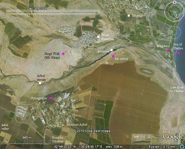
  • Annotated Satellite view of Arbel and environs from BibleWalks.com
  • Aerial view of synagogue from BibleWalks.com
  • Arbel in Google Earth
  • Arbel on govmap.gov.il

Plans

  • Plan of the synagogue in its earlier and later phases from Stern et al. (1993 v. 1)
  • Reconstruction of the early phase of the synagogue from Stern et al. (1993 v. 1)

Chronology
Chronology

Based on architectural details, the synagogue is thought to have originally been constructed in the 4th century CE and have undergone a series of modifications including, at one point, a rebuild over previous ruins (Ilan and Izdarechet in Stern et al, 1993) - perhaps in the 6th century CE. Ilan and Izdarechet in (Stern et al, 1993) note that the synagogue appears to have been destroyed in the mid-eighth century CE. This is apparently based on numismatic evidence however, as noted by Ilan and Izdarechet, coins recovered from the site were found on the surface rather than in a stratigraphic context. Ilan and Izdarechet in (Stern et al, 1993) hypothesized that it is possible that after the destruction of the synagogue and the community in the eighth century, the site remained desolate for two to three hundred years, until it was resettled in the Ayyubid period. Amiran et al (1994) related that the synagogue was destroyed by an earthquake in the mid 8th century based on a personal communication with the late Z. Ilan of the Israel Department of Antiquities and Museums in 1989.

Seismic Effects
mid 8th century CE earthquake

Effect Location Image (s) Comments
Presumed collapsed wall, roof, and column collapse Synagogue
  • JW: Details are lacking but if the synagogue was destroyed by an earthquake, one could expect wall collapse, roof collapse, and column collapse.

Intensity Estimates
mid 8th century CE earthquake

Effect Location Image (s) Comments Intensity
Presumed collapsed wall, roof, and column collapse Synagogue
  • JW: Details are lacking but if the synagogue was destroyed by an earthquake, one could expect wall collapse, roof collapse, and column collapse.
VIII+
The archeoseismic evidence requires a minimum Intensity of VIII (8) when using the Earthquake Archeological Effects chart of Rodríguez-Pascua et al (2013: 221-224).

Notes and Further Reading
References

Articles and Books

Abel, in: RB, 33 (1924), 380ff.; idem

Avigad, N. and H.Z. Hirschberg, H.Z. (eds.), Kol Ereẓ Naftali (1967), 98–100

Avi-Yonah, Geog, 140; EM, 2 (1954), 68; Press, Ereẓ, 1 (1951), 34–36

Kohl, H. and Watzinger, C., Antike Synagogen in Galilaea (1916), 59

Ilan, Z. Ancient Synagogues in Israel (1991), 116–18.

Klein, S. (ed.), Sefer ha-Yishuv, 1 (1939), 163

Les Livres des Maccabées (1949), 159

Sukenik, in: JPOS, 15 (1935), 143

Tsafrir, Y., Di Segni, L., and Green, J., Tabula Imperii Romani. Iudaea – Palaestina. Maps and Gazetteer. (1994), 168–68

Urman, D. and Flesher, P.V.M. (eds.), Ancient Synagogues, vol. I (1995)

Vitto, F. "Synagogues in Cupboards," in: Eretz Magazine, 52 (1997), 36–42

Websites

Entry for Arbel in the Jewish Virtual Library

Brochure for Arbel National Park and Nature Reserve (in English) - the brochure suggests that the synagogue rebuild took place in the 6th century CE and final destruction took place in 749 CE.

Arbel at BibleWalks.com

Bibliography from Stern et al. (2008)

S. Klein, Beiträge zur Geographie und Geschichte Galilaeas (Ph.D. diss., Heidelberg), Leipzig 1909

G. H. Dalman, ZDPV 29 (1906), 199–200

G. Foerster, The Galilean Synagogues and Their Relation to Hellenistic and Roman Art and Architecture, 1–2 (Ph.D. diss.), Jerusalem 1972

D. Chen, LA 36 (1986), 235–240

39 (1989), 199–206

Z. Ilan, ESI 6 (1987–1988), 110

7–8 (1988–1989), 8–9

9 (1989–1990), 17–18

id., Eretz Magazine 4/1 (1988–1989), 60–69

id., IEJ 39 (1989), 100–102

id. (& A. Izdarechet), MdB 57 (1989), 54–57

A. Van der Heyden, Ariel, Eng. ed. 82 (1990), 74–86

Y. Shahar & Y. Tepper, Cathedra 61 (1991), 191

M. Gichon, Historische Interpretationen (G. Walser Fest.

ed. M. Weinmann-Walser), Stuttgart 1995, 61–79

Z. Safrai, Studies in Historical Geography, Leiden 2000, 82–83.

Wikipedia page for Mount Arbel