Tiberias - Galei Kinneret
 Tiberias Galei Kinneret
click on image to explore this site on a new tab in govmap.gov.il
- Fig. 1 Map of Tiberias
during the Roman period from Atrash (2010)
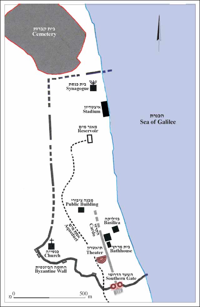 Figure 1.
The city during the Roman period, plan (based on Hirschfeld 1992)
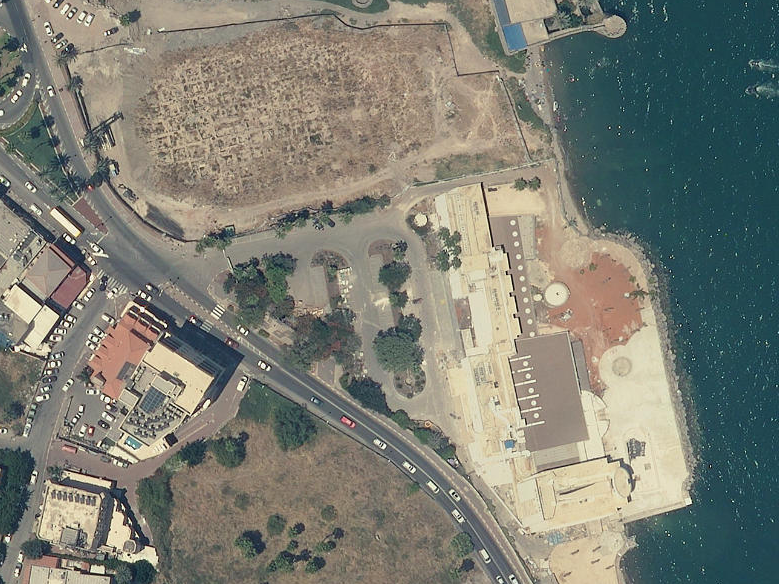
Galei Kinneret is next to the Stadium
Atrash (2010)
- Tiberias Galei Kinneret in Google Earth
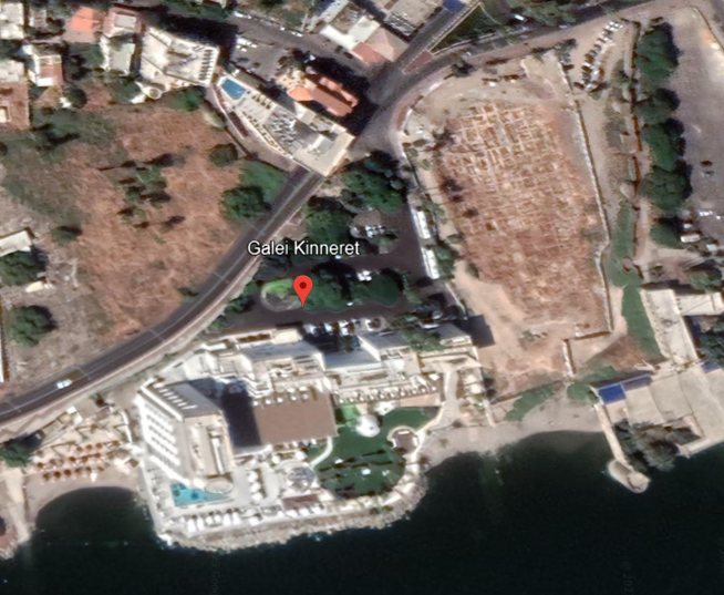 Tiberias Galei Kinneret
click on image to explore this site on a new tab in Google Earth - Tiberias Galei Kinneret on govmap.gov.il
Tiberias Galei Kinneret
click on image to explore this site on a new tab in govmap.gov.il
- Fig. 1 Plan of Galei
Kinneret excavations from Hartal (2008)
 Figure 1.
Plan
Hartal (2008) - Fig. 2 Plan of Galei
Kinneret excavations from Marco et al (2003)
 Figure 2.
Galei Kinneret site map.
A: Open fractures in Herod's stadium and overlying Byzantine walls.
B: Ummayad room that overlies fault (red lines) is tilted 23° westward. Its right side is on footwall, and its left side is on hanging wall. Arrow shows tear in wall.
C: Looking southward at section in alluvium and lake sediments, which buried Byzantine wall (right) and were later offset 40 cm by normal fault (red). White arrows point at offset layer; white bars are at bottom of unfaulted layers.
Foundation (pink) of Early Arabic (Abassid) wall is built into postfault layers. This stratigraphy constrains fault to eighth century. The only strong earthquake in this area occurred on 18 January 749.
Marco et al (2003)
- Fig. 1 Plan of Galei
Kinneret excavations from Hartal (2008)
Figure 1.
Plan
Hartal (2008) - Fig. 2 Plan of Galei
Kinneret excavations from Marco et al (2003)
Figure 2.
Galei Kinneret site map.
A: Open fractures in Herod's stadium and overlying Byzantine walls.
B: Ummayad room that overlies fault (red lines) is tilted 23° westward. Its right side is on footwall, and its left side is on hanging wall. Arrow shows tear in wall.
C: Looking southward at section in alluvium and lake sediments, which buried Byzantine wall (right) and were later offset 40 cm by normal fault (red). White arrows point at offset layer; white bars are at bottom of unfaulted layers.
Foundation (pink) of Early Arabic (Abassid) wall is built into postfault layers. This stratigraphy constrains fault to eighth century. The only strong earthquake in this area occurred on 18 January 749.
Marco et al (2003)
- Fig. 2A Extensional fractures
in Herod's stadium and overlying Byzantine walls from Marco et al (2003)
 Figure 2A
Open fractures in Herod's stadium and overlying Byzantine walls.
Marco et al (2003) - Fig. 3 Extensional fractures
in Byzantine walls (same location as Fig. 2A of Marco et al, 2003) from Hartal (2008)
 Figure 3.
Stadium wall with a Byzantine and Umayyad building above it, looking east.
Hartal (2008) - Extensional fractures
in Byzantine walls (same location as Fig. 2A of Marco et al, 2003) from Stern et al. (2008)
 Massive first-century CE curved wall, perhaps of a Roman stadium, underlying
a Byzantine structure (site 16 at the Galei Kinneret Hotel).
Massive first-century CE curved wall, perhaps of a Roman stadium, underlying
a Byzantine structure (site 16 at the Galei Kinneret Hotel).
JW: This is the same structure in Fig. 2A of Marco et al. (2003). Note extensional fractures and human at the top of the photo for scale.
Stern et al. (2008) - Fig. 4 Fractured stadium
wall from Hartal (2008)
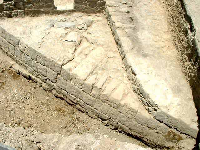 Figure 4
Stadium wall, looking north.
Hartal (2008) - Fig. 2B Tilted Umayyad
wall from Marco et al (2003)
 Figure 2B
Umayyad room that overlies fault (red lines) is tilted 23° westward. Its right side is on footwall, and its left side is on hanging wall. Arrow shows tear in wall.
JW: view from the south
Marco et al (2003) - Fig. 7 Tilted Byzantine-Umayyad
wall (same wall as in Fig. 2B from Marco et al., 2003) from Hartal (2008)
 Figure 7
Walls from the Byzantine–Umayyad periods; the wall on the right was damaged by the earthquake.
Hartal (2008) - Fig. 12 Tilted Byzantine-Umayyad
wall (same wall as in Fig. 2B from Marco et al., 2003) from Hartal (2008)
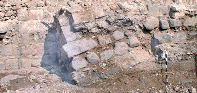 Figure 12
Wall destroyed in the earthquake, looking west.
Hartal (2008) - Fig. 2C Normal synsedimentary
faults offsetting the lower part of the sedimentary sequence from Marco et al (2003)
 Figure 2C
Looking southward at section in alluvium and lake sediments, which buried Byzantine wall (right) and were later offset 40 cm by normal fault (red). White arrows point at offset layer; white bars are at bottom of unfaulted layers.
JW: view from the north
Marco et al (2003) - Fig. 11 Normal synsedimentary
faults offsetting the lower part of the sedimentary sequence (same as in Fig. 2C from Marco et al., 2003) from Hartal (2008)
 Figure 11
Geological fault that shifted strata of the Byzantine period; the upper layers accumulated after the earthquake, looking south.
Hartal (2008) - Fig. 8 Byzantine-Umayyad
columns from Hartal (2008)
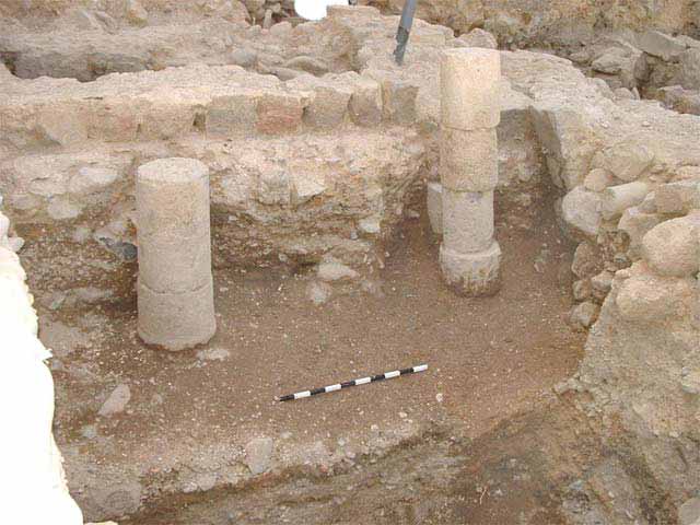 Figure 8
Columns from the Byzantine and Umayyad periods, looking west.
Hartal (2008) - Fig. 9 Column base
from Hartal (2008)
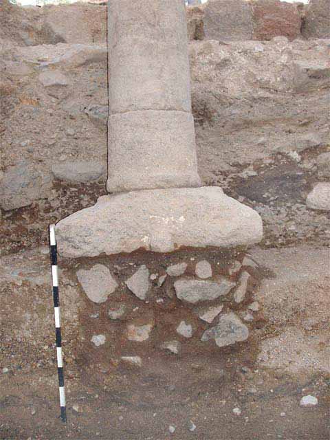 Figure 9
Nabatean capital in secondary use as a column base, looking west.
Hartal (2008)
- Fig. 3 Extensional fractures
in Byzantine walls (same location as Fig. 2A of Marco et al, 2003) from Hartal (2008)
Figure 3.
Stadium wall with a Byzantine and Umayyad building above it, looking east.
Hartal (2008) - Extensional fractures
in Byzantine walls (same location as Fig. 2A of Marco et al, 2003) from Stern et al. (2008)
Massive first-century CE curved wall, perhaps of a Roman stadium, underlying
a Byzantine structure (site 16 at the Galei Kinneret Hotel).
JW: This is the same structure in Fig. 2A of Marco et al. (2003). Note extensional fractures and human at the top of the photo for scale.
Stern et al. (2008) - Fig. 4 Fractured stadium
wall from Hartal (2008)
Figure 4
Stadium wall, looking north.
Hartal (2008) - Fig. 7 Tilted Byzantine-Umayyad
wall (same wall as in Fig. 2B from Marco et al., 2003) from Hartal (2008)
Figure 7
Walls from the Byzantine–Umayyad periods; the wall on the right was damaged by the earthquake.
Hartal (2008) - Fig. 12 Tilted Byzantine-Umayyad
wall (same wall as in Fig. 2B from Marco et al., 2003) from Hartal (2008)
Figure 12
Wall destroyed in the earthquake, looking west.
Hartal (2008) - Fig. 11 Normal synsedimentary
faults offsetting the lower part of the sedimentary sequence (same as in Fig. 2C from Marco et al., 2003) from Hartal (2008)
Figure 11
Geological fault that shifted strata of the Byzantine period; the upper layers accumulated after the earthquake, looking south.
Hartal (2008)
- Fig. 4 E–W section crossing
Galei Kinneret from Hazan et al (2004)
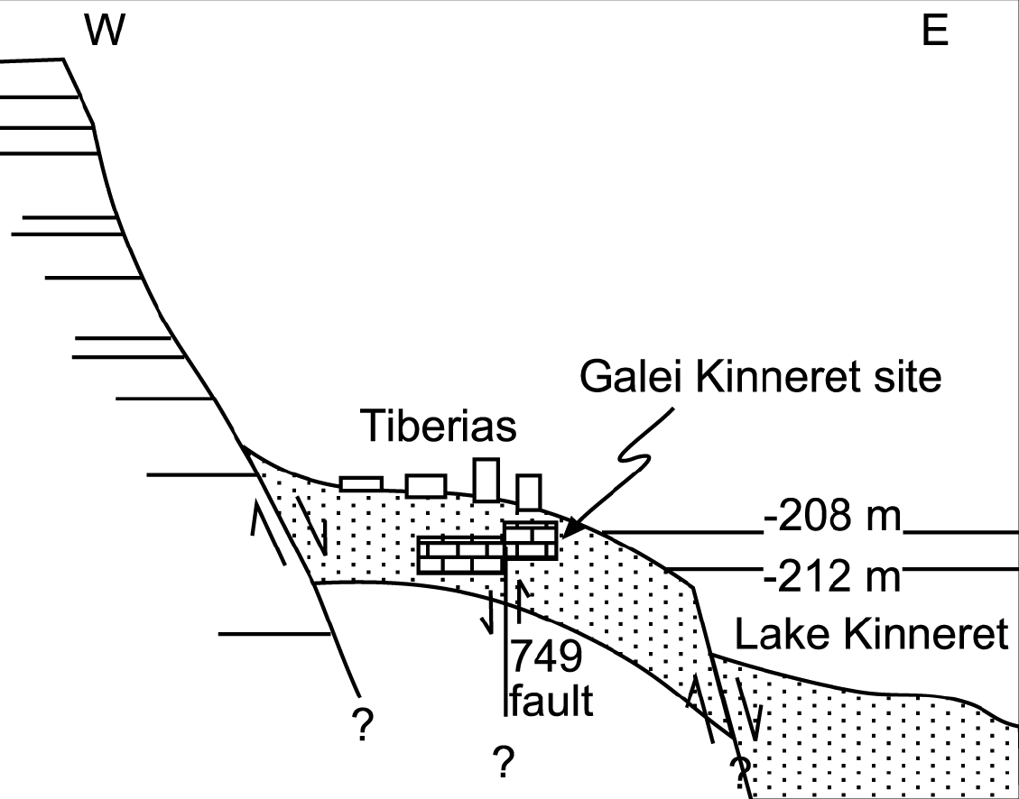 Figure 4
A schematic E–W section in the Tiberias area.
Hazan et al (2004)
- Fig. 1 Map of Tiberias
during the Roman period from Atrash (2010)
Figure 1.
The city during the Roman period, plan (based on Hirschfeld 1992)
Galei Kinneret is next to the Stadium
Atrash (2010)
- Fig. 2 Plan of Galei
Kinneret excavations Marco et al (2003)
Figure 2.
Galei Kinneret site map.
A: Open fractures in Herod's stadium and overlying Byzantine walls.
B: Ummayad room that overlies fault (red lines) is tilted 23° westward. Its right side is on footwall, and its left side is on hanging wall. Arrow shows tear in wall.
C: Looking southward at section in alluvium and lake sediments, which buried Byzantine wall (right) and were later offset 40 cm by normal fault (red). White arrows point at offset layer; white bars are at bottom of unfaulted layers.
Foundation (pink) of Early Arabic (Abassid) wall is built into postfault layers. This stratigraphy constrains fault to eighth century. The only strong earthquake in this area occurred on 18 January 749.
Marco et al (2003)
- Fig. 2A Extensional fractures
in Herod's stadium and overlying Byzantine walls from Marco et al (2003)
Figure 2A
Open fractures in Herod's stadium and overlying Byzantine walls.
Marco et al (2003) - Fig. 2B Tilted Umayyad
wall from Marco et al (2003)
Figure 2B
Umayyad room that overlies fault (red lines) is tilted 23° westward. Its right side is on footwall, and its left side is on hanging wall. Arrow shows tear in wall.
JW: view from the south
Marco et al (2003) - Fig. 2C Normal synsedimentary
faults offsetting the lower part of the sedimentary sequence from Marco et al (2003)
Figure 2C
Looking southward at section in alluvium and lake sediments, which buried Byzantine wall (right) and were later offset 40 cm by normal fault (red). White arrows point at offset layer; white bars are at bottom of unfaulted layers.
JW: view from the north
Marco et al (2003)
| Damage Type | Location | Image(s) | Comments |
|---|---|---|---|
| 4+ m of shoreline subsidence pre dating the mid 8th century CE earthquake | immediately offshore from Galei Kinneret |
Figure 4 A schematic E–W section in the Tiberias area. Hazan et al (2004) |
|
| Damage Type | Location | Image(s) | Comments |
|---|---|---|---|
| Penetrative extensional fractures in masonry blocks | Herod's stadium and overling Byzantine walls
Figure 2. Galei Kinneret site map. A: Open fractures in Herod's stadium and overlying Byzantine walls. B: Ummayad room that overlies fault (red lines) is tilted 23° westward. Its right side is on footwall, and its left side is on hanging wall. Arrow shows tear in wall. C: Looking southward at section in alluvium and lake sediments, which buried Byzantine wall (right) and were later offset 40 cm by normal fault (red). White arrows point at offset layer; white bars are at bottom of unfaulted layers. Foundation (pink) of Early Arabic (Abassid) wall is built into postfault layers. This stratigraphy constrains fault to eighth century. The only strong earthquake in this area occurred on 18 January 749. Marco et al (2003) |
Figure 2A Open fractures in Herod's stadium and overlying Byzantine walls. Marco et al (2003)
Figure 3.Stadium wall with a Byzantine and Umayyad building above it, looking east. Hartal (2008)
Massive first-century CE curved wall, perhaps of a Roman stadium, underlying
a Byzantine structure (site 16 at the Galei Kinneret Hotel).JW: This is the same structure in Fig. 2A of Marco et al. (2003). Note extensional fractures and human at the top of the photo for scale. Stern et al. (2008)
Figure 4Stadium wall, looking north. Hartal (2008) |
|
| Tilted Walls | Umayyad room
Figure 2. Galei Kinneret site map. A: Open fractures in Herod's stadium and overlying Byzantine walls. B: Ummayad room that overlies fault (red lines) is tilted 23° westward. Its right side is on footwall, and its left side is on hanging wall. Arrow shows tear in wall. C: Looking southward at section in alluvium and lake sediments, which buried Byzantine wall (right) and were later offset 40 cm by normal fault (red). White arrows point at offset layer; white bars are at bottom of unfaulted layers. Foundation (pink) of Early Arabic (Abassid) wall is built into postfault layers. This stratigraphy constrains fault to eighth century. The only strong earthquake in this area occurred on 18 January 749. Marco et al (2003) |
Figure 2B Umayyad room that overlies fault (red lines) is tilted 23° westward. Its right side is on footwall, and its left side is on hanging wall. Arrow shows tear in wall. JW: view from the south Marco et al (2003)
Figure 7Walls from the Byzantine–Umayyad periods; the wall on the right was damaged by the earthquake. Hartal (2008)
Figure 12Wall destroyed in the earthquake, looking west. Hartal (2008) |
|
| Faulting | alluvium and lake sediments which buried Byzantine wall
Figure 2. Galei Kinneret site map. A: Open fractures in Herod's stadium and overlying Byzantine walls. B: Ummayad room that overlies fault (red lines) is tilted 23° westward. Its right side is on footwall, and its left side is on hanging wall. Arrow shows tear in wall. C: Looking southward at section in alluvium and lake sediments, which buried Byzantine wall (right) and were later offset 40 cm by normal fault (red). White arrows point at offset layer; white bars are at bottom of unfaulted layers. Foundation (pink) of Early Arabic (Abassid) wall is built into postfault layers. This stratigraphy constrains fault to eighth century. The only strong earthquake in this area occurred on 18 January 749. Marco et al (2003) |
Figure 2C Looking southward at section in alluvium and lake sediments, which buried Byzantine wall (right) and were later offset 40 cm by normal fault (red). White arrows point at offset layer; white bars are at bottom of unfaulted layers. JW: view from the north Marco et al (2003)
Figure 11Geological fault that shifted strata of the Byzantine period; the upper layers accumulated after the earthquake, looking south. Hartal (2008) |
|
| Possible liquefaction leading to sinking buildings, cracked and displaced walls, and a collapsed building. | western part of the site including the northern and southern buildings
Figure 1. Plan Hartal (2008) |
Figure 11 Geological fault that shifted strata of the Byzantine period; the upper layers accumulated after the earthquake, looking south. Hartal (2008)
Figure 12Wall destroyed in the earthquake, looking west. Hartal (2008) |
|
| Fallen pottery | Northern building
Figure 1. Plan Hartal (2008) |
|
- Modified by JW from Fig. 2 of Marco et al (2003)
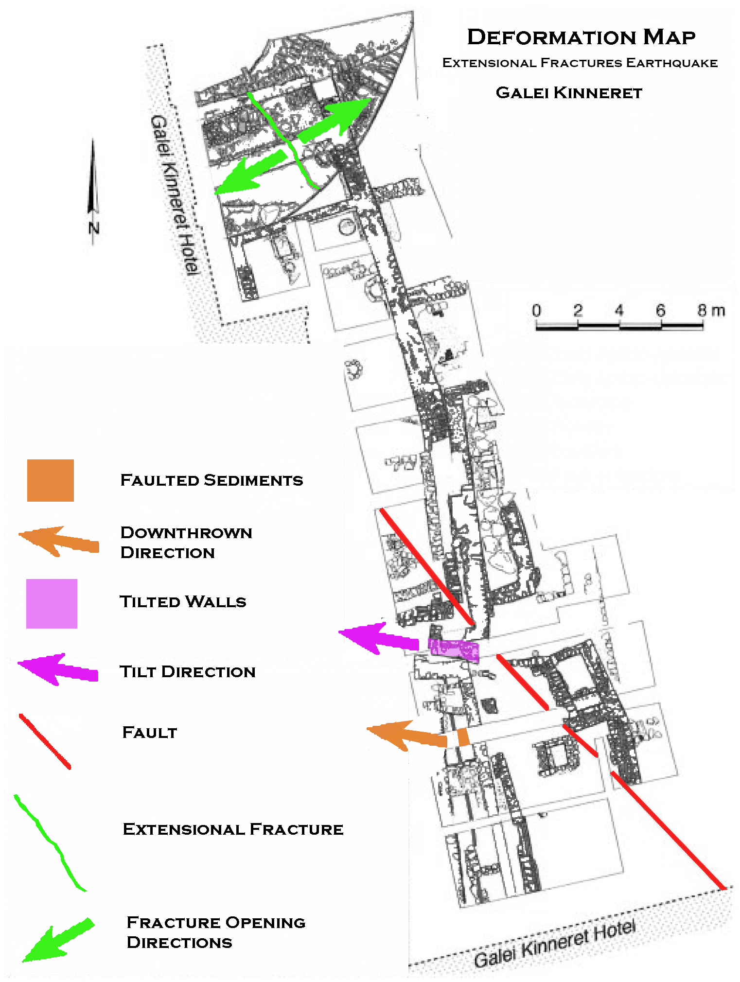 Deformation Map
Click on image to open in a new tab
Modified by JW from Fig. 2 of Marco et al (2003)
- Earthquake Archeological Effects chart
of Rodríguez-Pascua et al (2013: 221-224)
 Earthquake Archeological Effects (EAE)
Rodríguez-Pascua et al (2013: 221-224)
| Damage Type | Location | Image(s) | Comments | Intensity |
|---|---|---|---|---|
| 4+ m of shoreline subsidence | immediately offshore from Galei Kinneret |
Figure 4 A schematic E–W section in the Tiberias area. Hazan et al (2004) |
|
VII + |
- Earthquake Archeological Effects chart
of Rodríguez-Pascua et al (2013: 221-224)
Earthquake Archeological Effects (EAE)
Rodríguez-Pascua et al (2013: 221-224)
| Damage Type | Location | Image(s) | Comments | Intensity |
|---|---|---|---|---|
| Penetrative extensional fractures in masonry blocks | Herod's stadium and overling Byzantine walls
Figure 2. Galei Kinneret site map. A: Open fractures in Herod's stadium and overlying Byzantine walls. B: Ummayad room that overlies fault (red lines) is tilted 23° westward. Its right side is on footwall, and its left side is on hanging wall. Arrow shows tear in wall. C: Looking southward at section in alluvium and lake sediments, which buried Byzantine wall (right) and were later offset 40 cm by normal fault (red). White arrows point at offset layer; white bars are at bottom of unfaulted layers. Foundation (pink) of Early Arabic (Abassid) wall is built into postfault layers. This stratigraphy constrains fault to eighth century. The only strong earthquake in this area occurred on 18 January 749. Marco et al (2003) |
Figure 2A Open fractures in Herod's stadium and overlying Byzantine walls. Marco et al (2003)
Figure 3.Stadium wall with a Byzantine and Umayyad building above it, looking east. Hartal (2008)
Massive first-century CE curved wall, perhaps of a Roman stadium, underlying
a Byzantine structure (site 16 at the Galei Kinneret Hotel).JW: This is the same structure in Fig. 2A of Marco et al. (2003). Note extensional fractures and human at the top of the photo for scale. Stern et al. (2008)
Figure 4Stadium wall, looking north. Hartal (2008) |
|
VI + |
| Tilted Walls | Umayyad room
Figure 2. Galei Kinneret site map. A: Open fractures in Herod's stadium and overlying Byzantine walls. B: Ummayad room that overlies fault (red lines) is tilted 23° westward. Its right side is on footwall, and its left side is on hanging wall. Arrow shows tear in wall. C: Looking southward at section in alluvium and lake sediments, which buried Byzantine wall (right) and were later offset 40 cm by normal fault (red). White arrows point at offset layer; white bars are at bottom of unfaulted layers. Foundation (pink) of Early Arabic (Abassid) wall is built into postfault layers. This stratigraphy constrains fault to eighth century. The only strong earthquake in this area occurred on 18 January 749. Marco et al (2003) |
Figure 2B Umayyad room that overlies fault (red lines) is tilted 23° westward. Its right side is on footwall, and its left side is on hanging wall. Arrow shows tear in wall. JW: view from the south Marco et al (2003)
Figure 7Walls from the Byzantine–Umayyad periods; the wall on the right was damaged by the earthquake. Hartal (2008)
Figure 12Wall destroyed in the earthquake, looking west. Hartal (2008) |
|
VI + |
| Faulting - Fault scarp | alluvium and lake sediments which buried Byzantine wall
Figure 2. Galei Kinneret site map. A: Open fractures in Herod's stadium and overlying Byzantine walls. B: Ummayad room that overlies fault (red lines) is tilted 23° westward. Its right side is on footwall, and its left side is on hanging wall. Arrow shows tear in wall. C: Looking southward at section in alluvium and lake sediments, which buried Byzantine wall (right) and were later offset 40 cm by normal fault (red). White arrows point at offset layer; white bars are at bottom of unfaulted layers. Foundation (pink) of Early Arabic (Abassid) wall is built into postfault layers. This stratigraphy constrains fault to eighth century. The only strong earthquake in this area occurred on 18 January 749. Marco et al (2003) |
Figure 2C Looking southward at section in alluvium and lake sediments, which buried Byzantine wall (right) and were later offset 40 cm by normal fault (red). White arrows point at offset layer; white bars are at bottom of unfaulted layers. JW: view from the north Marco et al (2003)
Figure 11Geological fault that shifted strata of the Byzantine period; the upper layers accumulated after the earthquake, looking south. Hartal (2008) |
|
VII + |
| Possible liquefaction leading to sinking buildings, cracked and displaced walls, and a collapsed building. | western part of the site including the northern and southern buildings
Figure 1. Plan Hartal (2008) |
Figure 11 Geological fault that shifted strata of the Byzantine period; the upper layers accumulated after the earthquake, looking south. Hartal (2008)
Figure 12Wall destroyed in the earthquake, looking west. Hartal (2008) |
|
VII + |
| Fallen pottery | Northern building
Figure 1. Plan Hartal (2008) |
|
VII + |