Umm al-Jimal
 Umm al-Jimal
click on image to explore this site on a new tab in Google Earth
| Transliterated Name | Language | Name |
|---|---|---|
| Umm al-Jimal | Arabic | ام الجمال |
| Umm al-Jamal | Arabic | ام الجمال |
| Umm ej Jemāl | Arabic | ام الجمال |
| Umm idj-Djimal | Arabic | ام الجمال |
| al-ʾHerrī - local name for older Roman village | Arabic | الءهيرري |
- Fig.11.1 Map of Umm al-Jimal
and surroundings from Lichtenberger and Raja (2025)
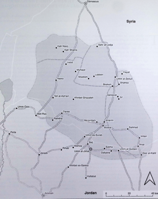 Figure 11.1
Umm Al-Jimal in its regional context with possible routes (figure after D. Rohl).
click on image to open in a new tab
Lichtenberger and Raja (2025)
- Fig.11.1 Map of Umm al-Jimal
and surroundings from Lichtenberger and Raja (2025)
Figure 11.1
Umm Al-Jimal in its regional context with possible routes (figure after D. Rohl).
click on image to open in a new tab
Lichtenberger and Raja (2025)
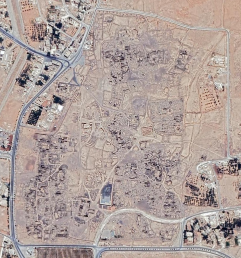
- Umm al-Jimal in Google Earth
Umm al-Jimal
click on image to explore this site on a new tab in Google Earth - Aerial Photo from APAAME
 Umm al-Jimal
APAAME
- Fig.11.2 Site Plan
from Lichtenberger and Raja (2025)
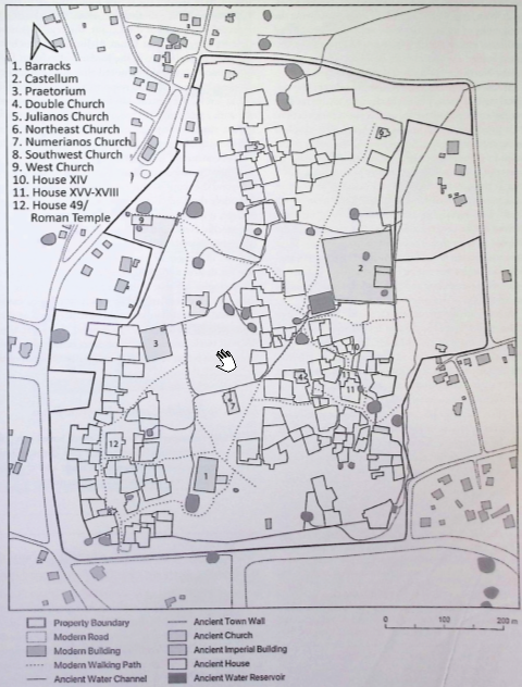 Figure 11.2
Plan of Umm al-Jimil showing the thirteen reviewed excavations (figure after D/ Rohl)
click on image to open in a new tab
Lichtenberger and Raja (2025) - Fig. 3 Site plan of town
and village from de Vries (1993)
 Fig. 3
Map of Umm el-Jimal showing town and village
Drawn by Bert de Vries and Randa Sayegh
de Vries (1993) - Fig. 2 Plan of late antique
Umm al-Jimal from de Vries (2000)
 Fig. 2
Plan at late antique Umm al-Jimal
(adapted from de Vries. Umm el-Jimal [1988] 94 fig. 44)
de Vries (2000) - Fig. 2 Site Plan from
de Vries, B. (1995)
 2. Map of southern section of Umm al-Jimal showing the location of house 119.
Building 1 is the Barracks
2 the Praetorium
8 the temple built into house 49
13 the Numerianos church
(Drawing by B. de Vries)
de Vries (1995)
- Fig.11.2 Site Plan
from Lichtenberger and Raja (2025)
Figure 11.2
Plan of Umm al-Jimil showing the thirteen reviewed excavations (figure after D/ Rohl)
click on image to open in a new tab
Lichtenberger and Raja (2025) - Fig. 3 Site plan of town
and village from de Vries (1993)
Fig. 3
Map of Umm el-Jimal showing town and village
Drawn by Bert de Vries and Randa Sayegh
de Vries (1993) - Fig. 2 Plan of late antique
Umm al-Jimal from de Vries (2000)
Fig. 2
Plan at late antique Umm al-Jimal
(adapted from de Vries. Umm el-Jimal [1988] 94 fig. 44)
de Vries (2000) - Fig. 2 Site Plan from
de Vries, B. (1995)
2. Map of southern section of Umm al-Jimal showing the location of house 119.
Building 1 is the Barracks
2 the Praetorium
8 the temple built into house 49
13 the Numerianos church
(Drawing by B. de Vries)
de Vries (1995)
- Fig.11.3 Plan of
the Praetorium from Lichtenberger and Raja (2025)
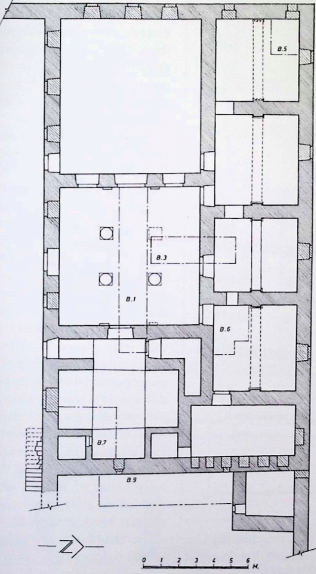 Figure 11.3
Plan of the Praetorium, showing excavation trenches (drawing: B. de Vries)
click on image to open in a new tab
Lichtenberger and Raja (2025)
- Fig.11.3 Plan of
the Praetorium from Lichtenberger and Raja (2025)
Figure 11.3
Plan of the Praetorium, showing excavation trenches (drawing: B. de Vries)
click on image to open in a new tab
Lichtenberger and Raja (2025)
- Fig.11.5 Plan of
the Barracks from Lichtenberger and Raja (2025)
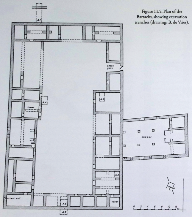 Figure 11.5
Plan of the Barracks, showing excavation trenches (drawing: B. de Vries)
click on image to open in a new tab
Lichtenberger and Raja (2025)
- Fig.11.5 Plan of
the Barracks from Lichtenberger and Raja (2025)
Figure 11.5
Plan of the Barracks, showing excavation trenches (drawing: B. de Vries)
click on image to open in a new tab
Lichtenberger and Raja (2025)
- Fig.11.6 Plan of
the Roman Temple from Lichtenberger and Raja (2025)
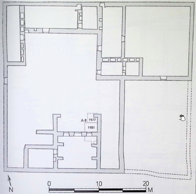 Figure 11.6
Plan of the Roman Temple, showing excavation trenches (drawing: J. Yeats; Figure: E. Osinga)
click on image to open in a new tab
Lichtenberger and Raja (2025)
- Fig.11.6 Plan of
the Roman Temple from Lichtenberger and Raja (2025)
Figure 11.6
Plan of the Roman Temple, showing excavation trenches (drawing: J. Yeats; Figure: E. Osinga)
click on image to open in a new tab
Lichtenberger and Raja (2025)
- Fig.11.7 Plan of
the Northeast Church from Lichtenberger and Raja (2025)
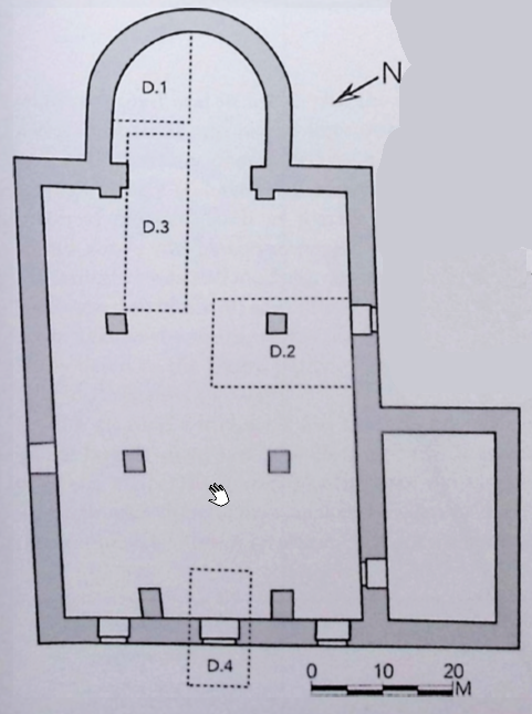 Figure 11.7
Preliminary Plan of the Northeast Church, showing excavation trenches (drawing: H. Verkuyl; Figure: E. Osinga)
click on image to open in a new tab
Lichtenberger and Raja (2025)
- Fig.11.7 Plan of
the Northeast Church from Lichtenberger and Raja (2025)
Figure 11.7
Preliminary Plan of the Northeast Church, showing excavation trenches (drawing: H. Verkuyl; Figure: E. Osinga)
click on image to open in a new tab
Lichtenberger and Raja (2025)
- Fig.11.8 Plan of
the Northeast Church from Lichtenberger and Raja (2025)
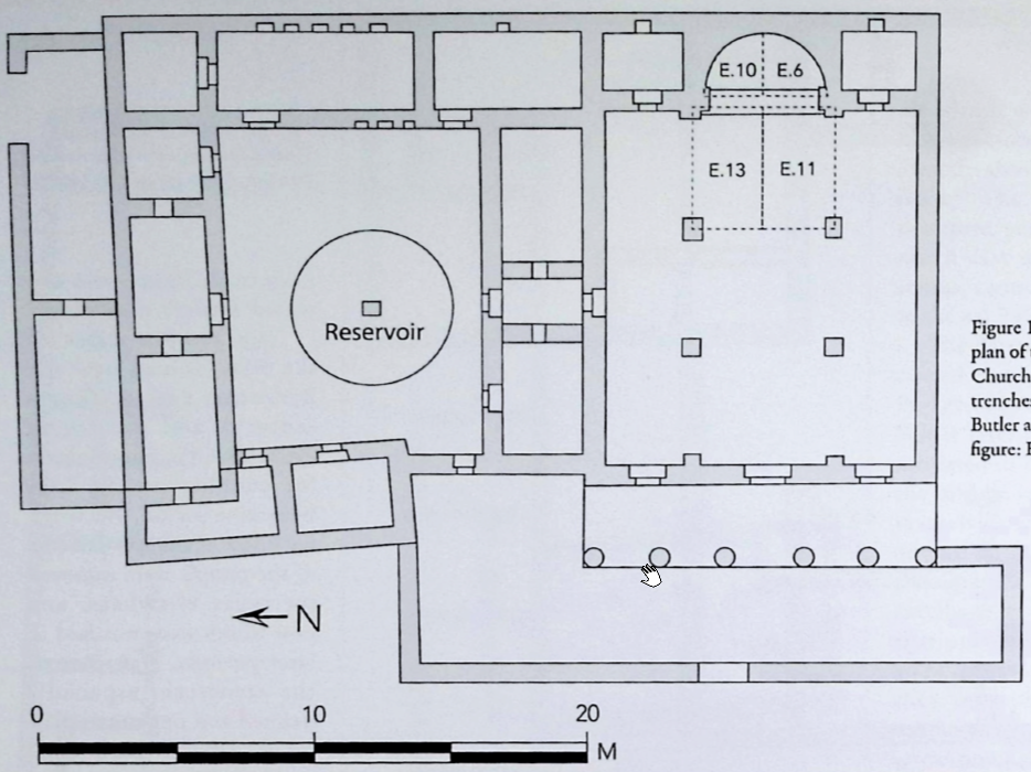 Figure 11.8
Preliminary Plan of the Numerianos Church, showing excavation trenches (drawing: H.C. Butler and B. de Vries; Figure: E. Osinga)
click on image to open in a new tab
Lichtenberger and Raja (2025)
- Fig.11.8 Plan of
the Northeast Church from Lichtenberger and Raja (2025)
Figure 11.8
Preliminary Plan of the Numerianos Church, showing excavation trenches (drawing: H.C. Butler and B. de Vries; Figure: E. Osinga)
click on image to open in a new tab
Lichtenberger and Raja (2025)
- Fig.11.9 Plan of
House XIV from Lichtenberger and Raja (2025)
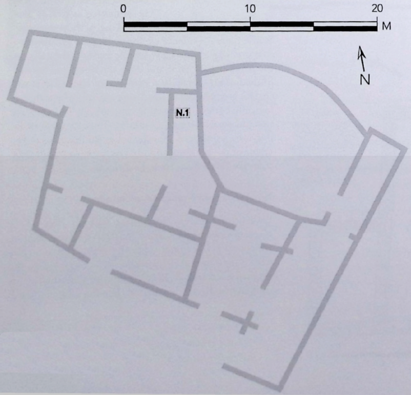 Figure 11.9
Sketch plan of House XIV, showing trench N.1 (drawing: H. Verkuyl; figure: E. Osinga)
click on image to open in a new tab
Lichtenberger and Raja (2025)
- Fig.11.9 Plan of
House XIV from Lichtenberger and Raja (2025)
Figure 11.9
Sketch plan of House XIV, showing trench N.1 (drawing: H. Verkuyl; figure: E. Osinga)
click on image to open in a new tab
Lichtenberger and Raja (2025)
- Fig.11.10 Plan of
House 119 from Lichtenberger and Raja (2025)
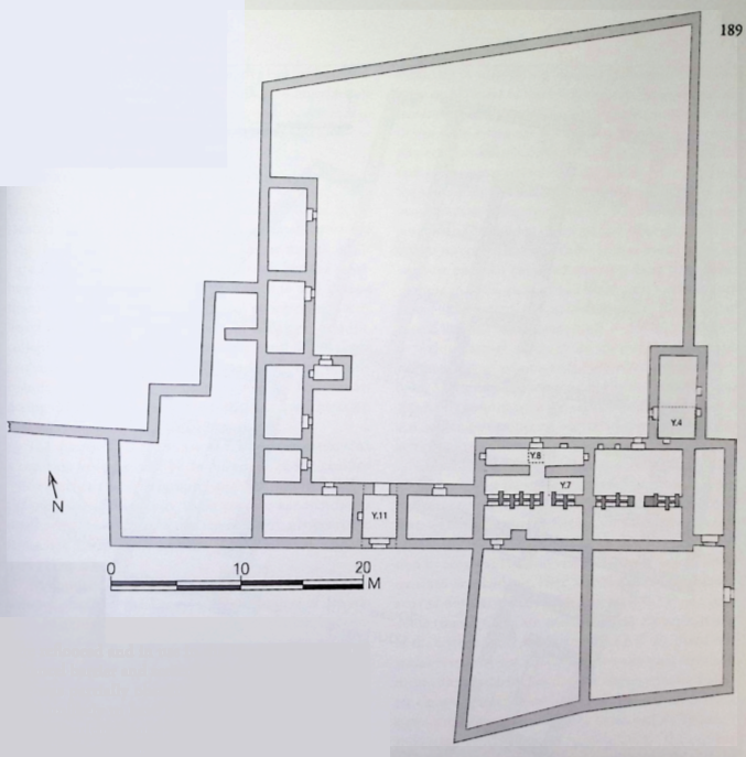 Figure 11.10
Plan of House 119, showing excavation trenches (drawing: D. Winnail; figure: E. Osinga)
click on image to open in a new tab
Lichtenberger and Raja (2025)
- Fig.11.10 Plan of
House 119 from Lichtenberger and Raja (2025)
Figure 11.10
Plan of House 119, showing excavation trenches (drawing: D. Winnail; figure: E. Osinga)
click on image to open in a new tab
Lichtenberger and Raja (2025)
- Fig.11.11 Plan of
House XVII-XVIII from Lichtenberger and Raja (2025)
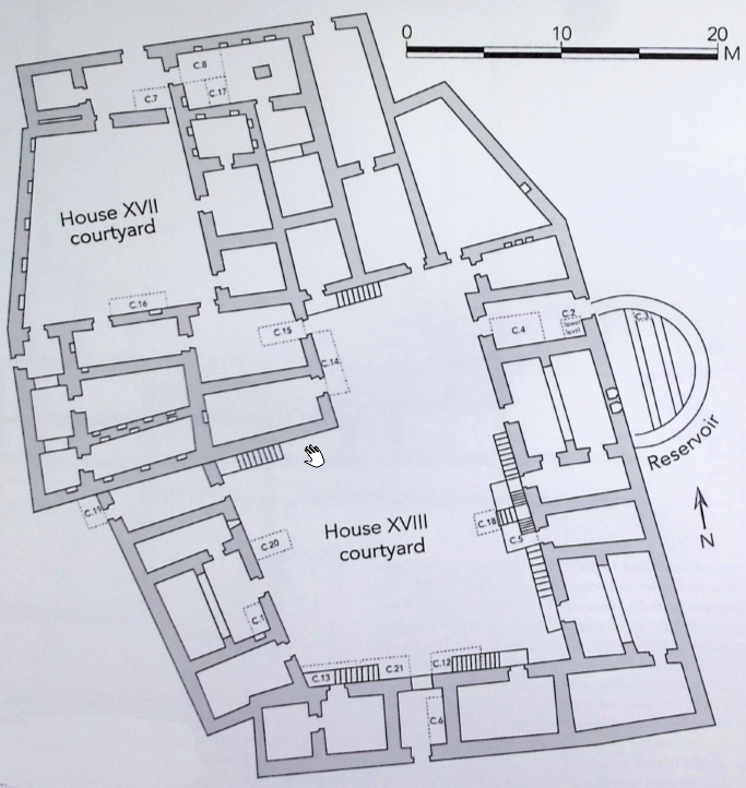 Figure 11.11
Plan of the ground floor of House XVII-XVIII, showing excavation trenches (drawing: M. al-Bataineh; figure: E. Osinga)
click on image to open in a new tab
Lichtenberger and Raja (2025)
- Fig.11.11 Plan of
House XVII-XVIII from Lichtenberger and Raja (2025)
Figure 11.11
Plan of the ground floor of House XVII-XVIII, showing excavation trenches (drawing: M. al-Bataineh; figure: E. Osinga)
click on image to open in a new tab
Lichtenberger and Raja (2025)
- Fig. 4 Plan of the castellum
from de Vries (1993)
 Fig. 4
Plan of the castellum
Drawn by Bert de Vries
de Vries (1993)
- Fig. 4 Plan of the castellum
from de Vries (1993)
Fig. 4
Plan of the castellum
Drawn by Bert de Vries
de Vries (1993)
- Plate 2.3 View of the Barracks
from de Vries (2000)
 Plate 2.3
Umm al-Jimal: general view of the Barracks
Photo A. Walmsley
de Vries (2000) - Plate 3.1 West facade of the Barracks
from de Vries (2000)
 Plate 3.1
Umm al·Jimal: detail of the west facade of the Barracks
Photo A. Walmsley
de Vries (2000) - Figure 3.2 The Western
Tower of the Barracks from Kázmér et al. (2024)
 Figure 3.2
Umm al-Jimal. Barracks: view of the western towers from the courtyard. The U-shaped collapse scar of the third-floor wall is a typical mark of seismic shaking. Note the rotated block on the right side of the scar and the twisted wall on the left side of the photo: these are further indicators of lateral loading, twisting, and collapse of walls.
Kázmér et al. (2024) - Figure 3.3 Western Wall
of the Barracks from Kázmér et al. (2024)
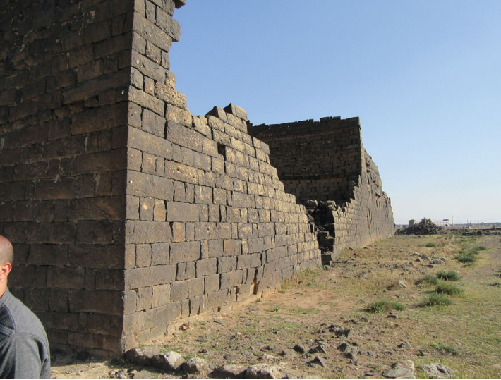 Figure 3.3
Umm al-Jimal. Barracks, western wall. Note the twisted walls below the U-shaped collapse feature. The wall closer to the viewer is tilted inwards, the farther one is bulging outwards. These are clear markers of repeated, strong lateral loading
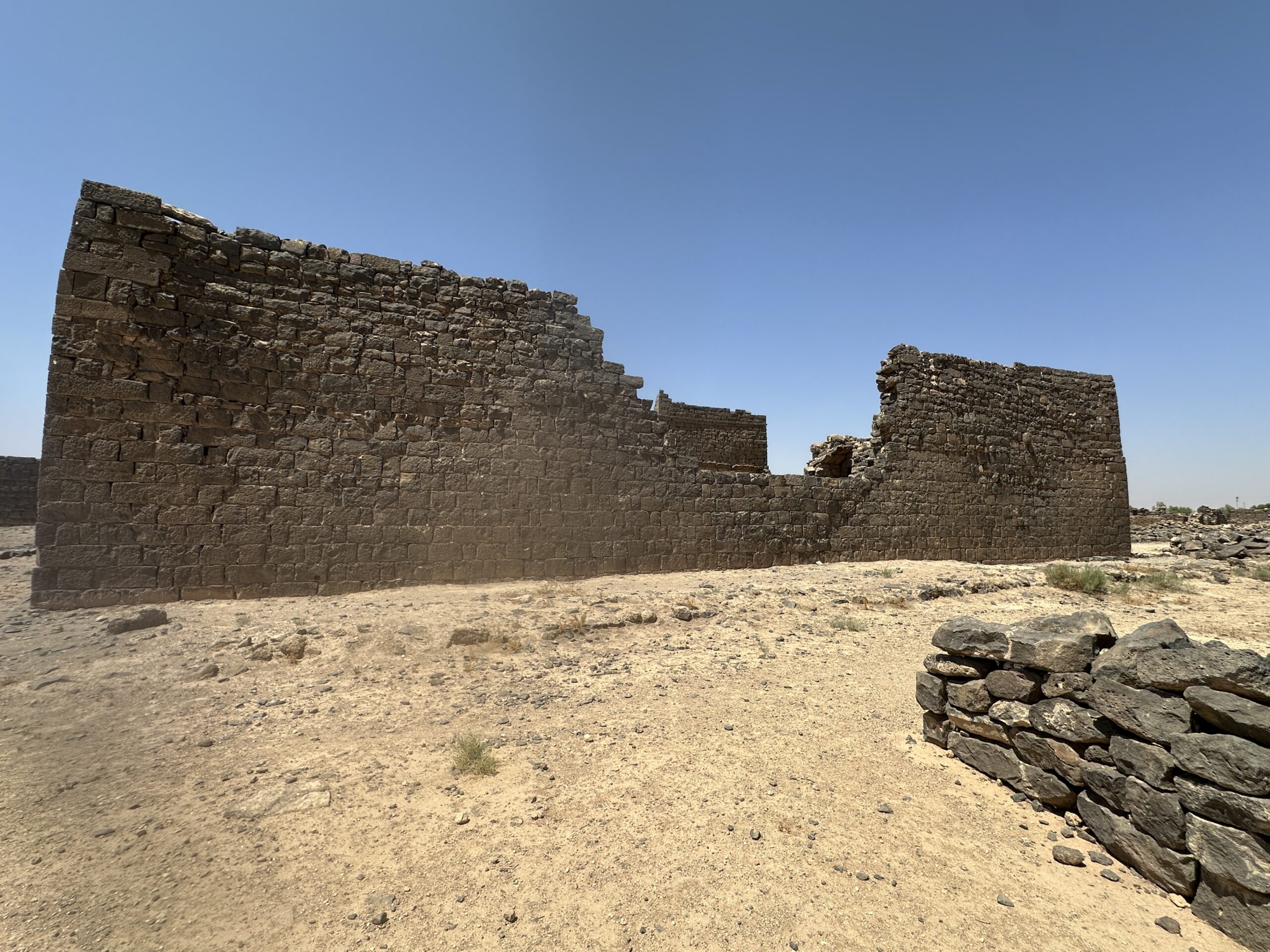
Kázmér et al. (2024) - Longshot of the barracks
in Umm al-Jimal - photo by JW
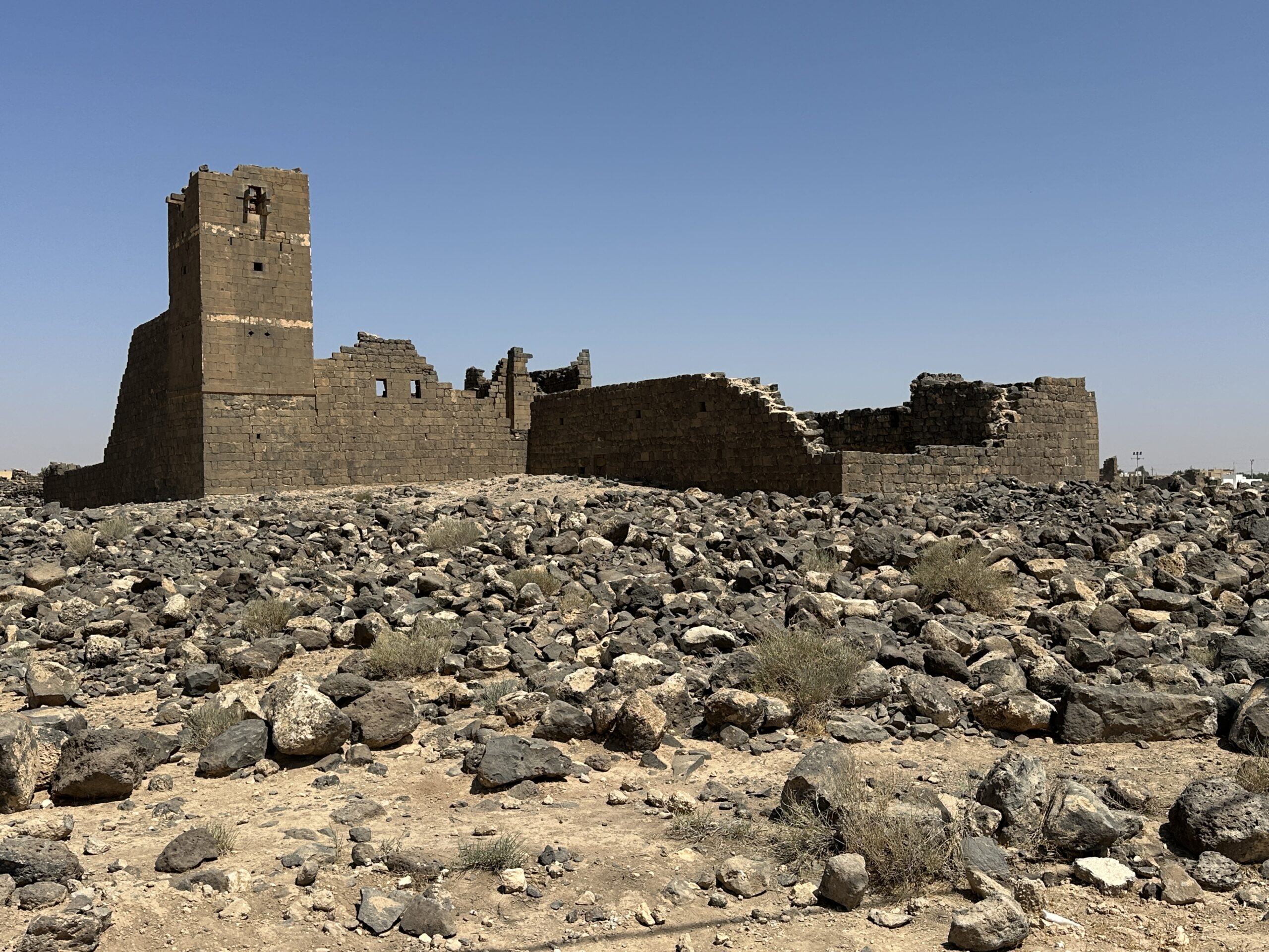 Longshot of the barracks in Umm al-Jimal
Photo by Jefferson Williams - 24 June 2025 - Park signage of the barracks
in Umm al-Jimal - photo by JW
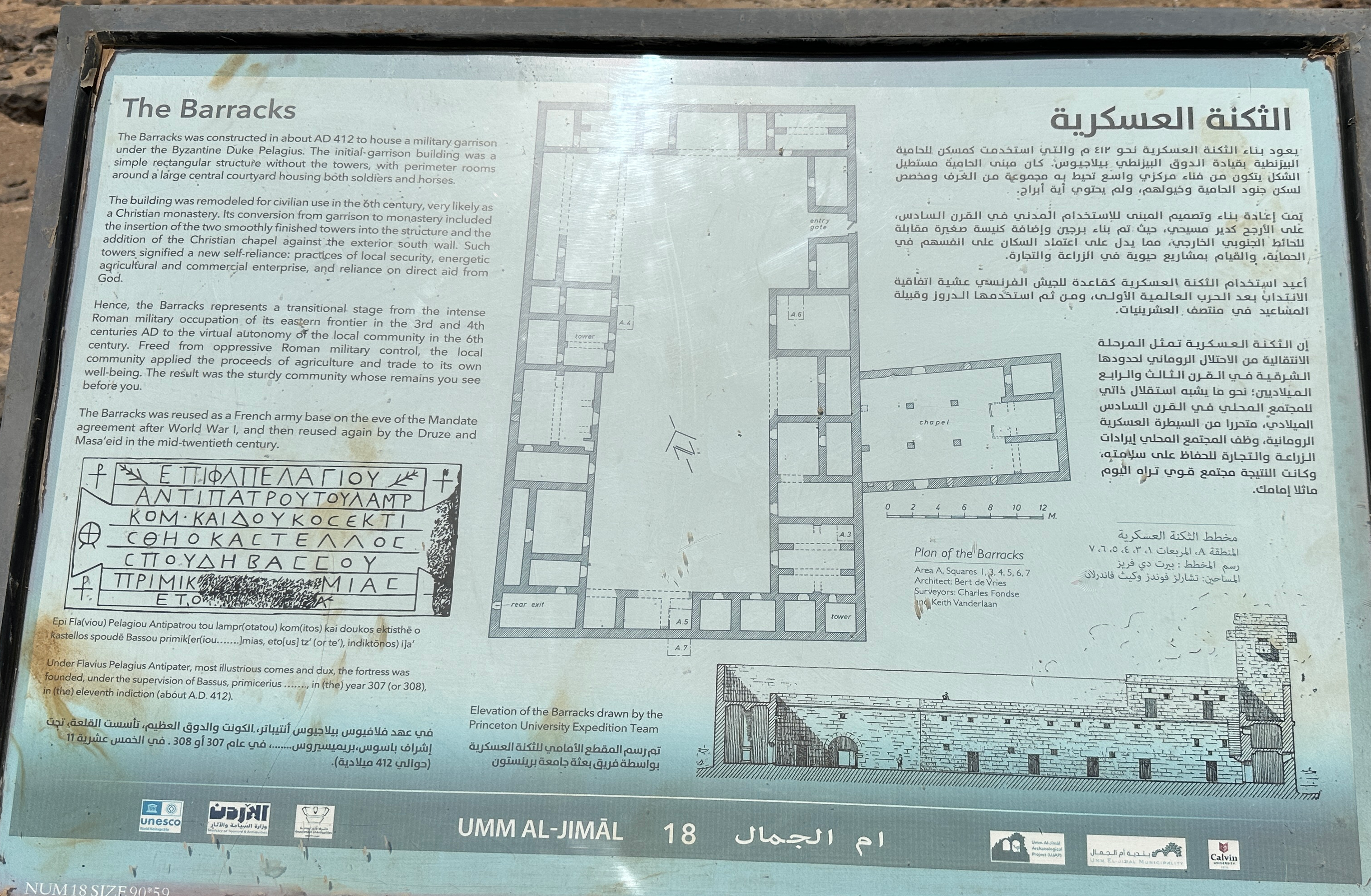 Park signage of the barracks in Umm al-Jimal
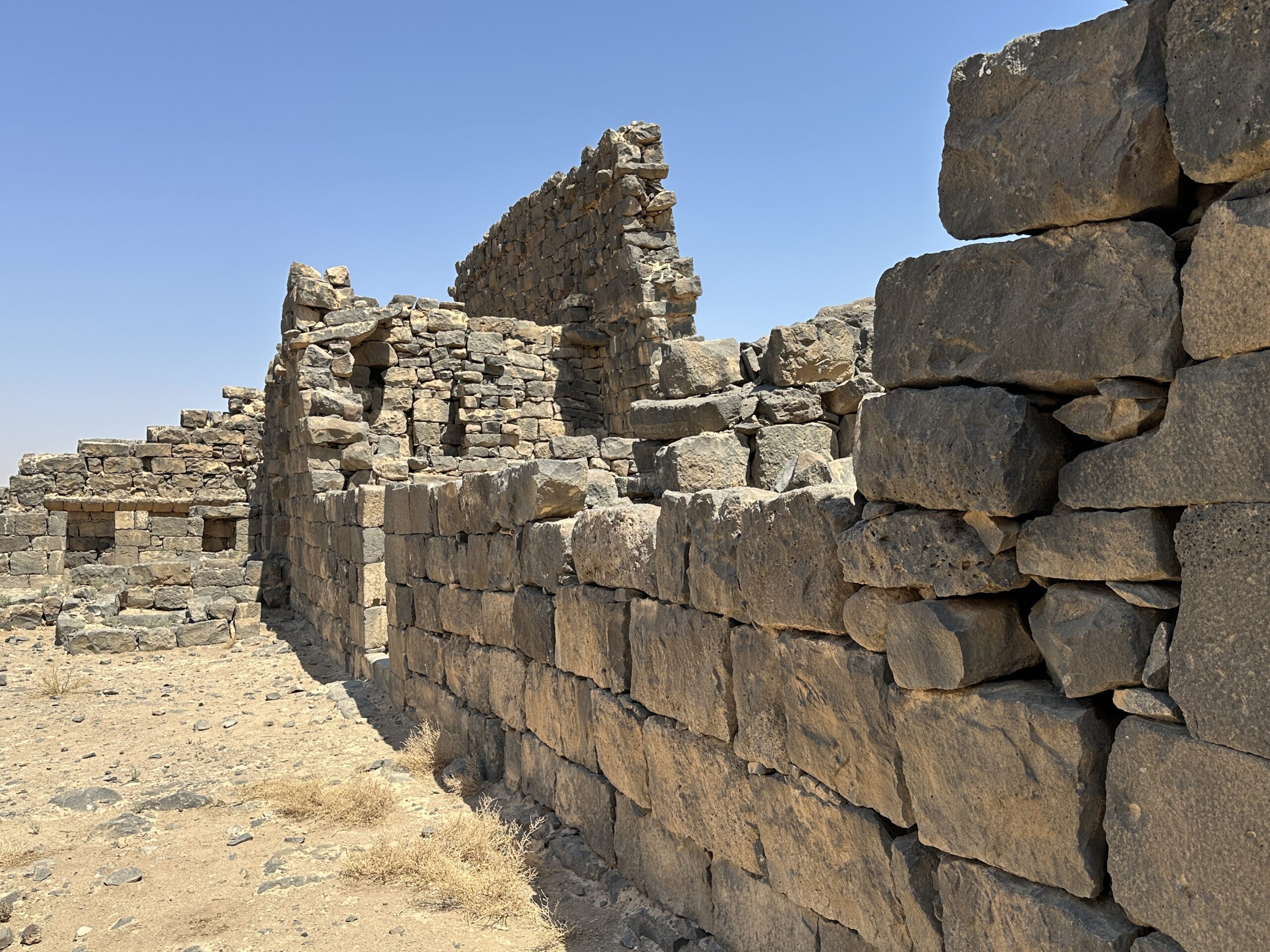
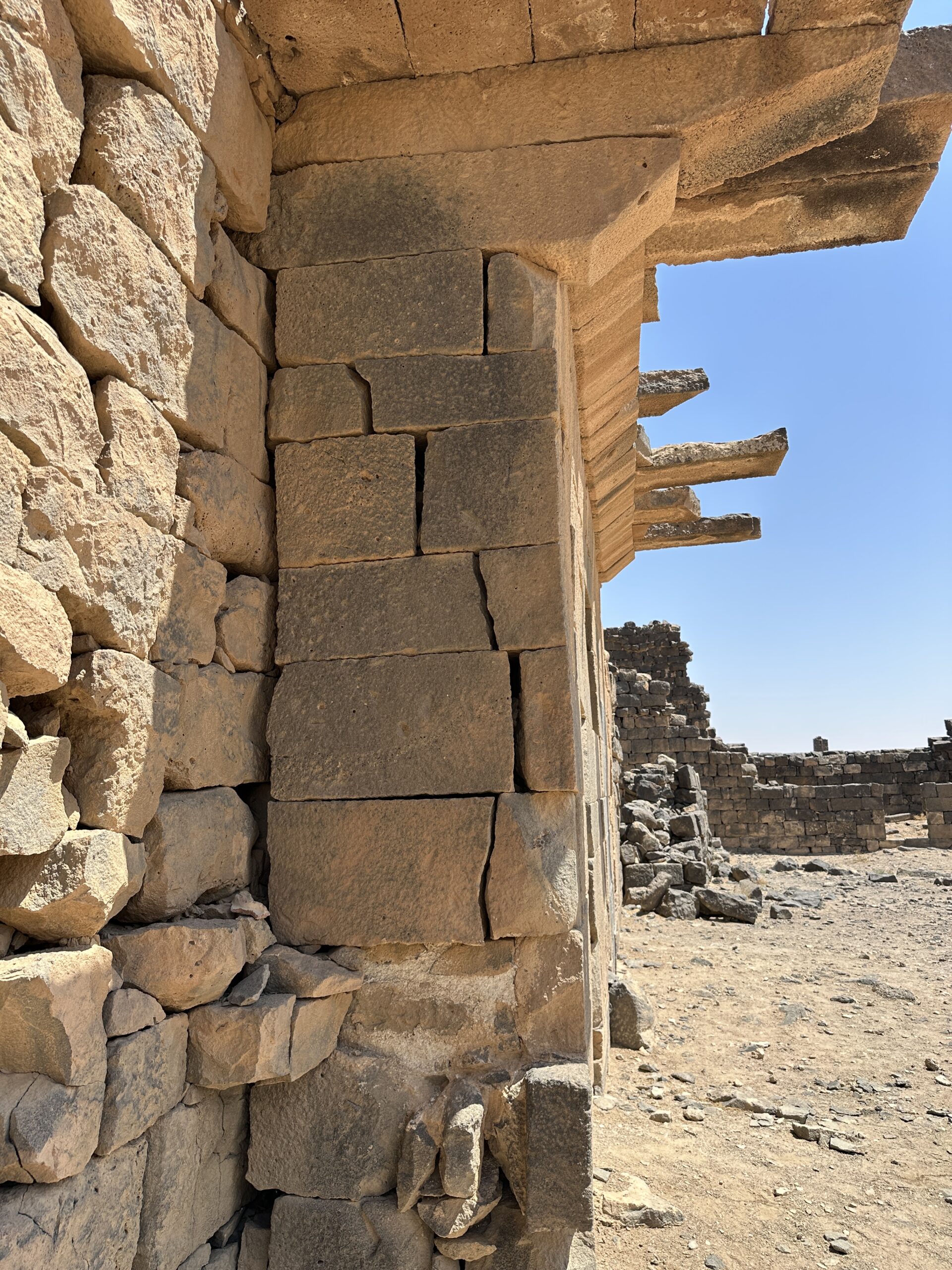
Photo by Jefferson Williams - 24 June 2025 - U shaped cutout at the barracks
in Umm al-Jimal - photo by JW
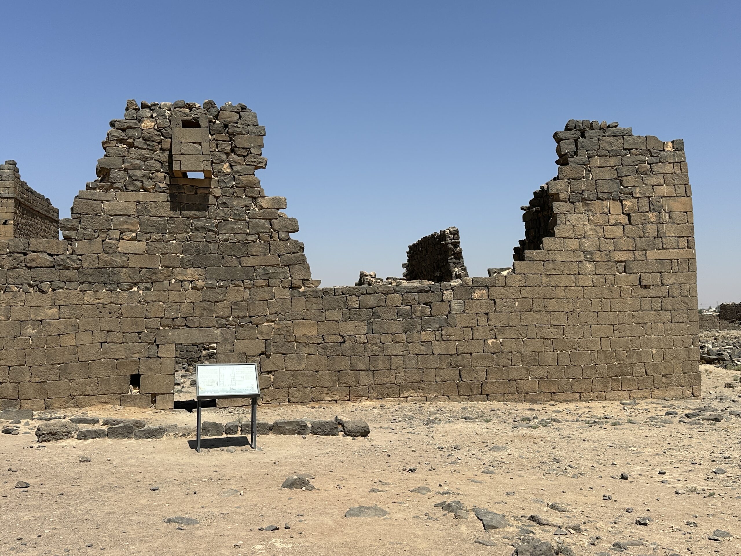 U shaped cutout at the barracks in Umm al-Jimal
Photo by Jefferson Williams - 24 June 2025 - Reconstructed U shaped
cutout at the barracks in Umm al-Jimal - photo by JW
 Reconstructed U shaped cutout at the barracks in Umm al-Jimal
Photo by Jefferson Williams - 24 June 2025 - Reconstructed U shaped
cutout next to U shaped cutout at the barracks in Umm al-Jimal - photo by JW
 Reconstructed U shaped cutout next to U shaped cutout at the barracks in Umm al-Jimal
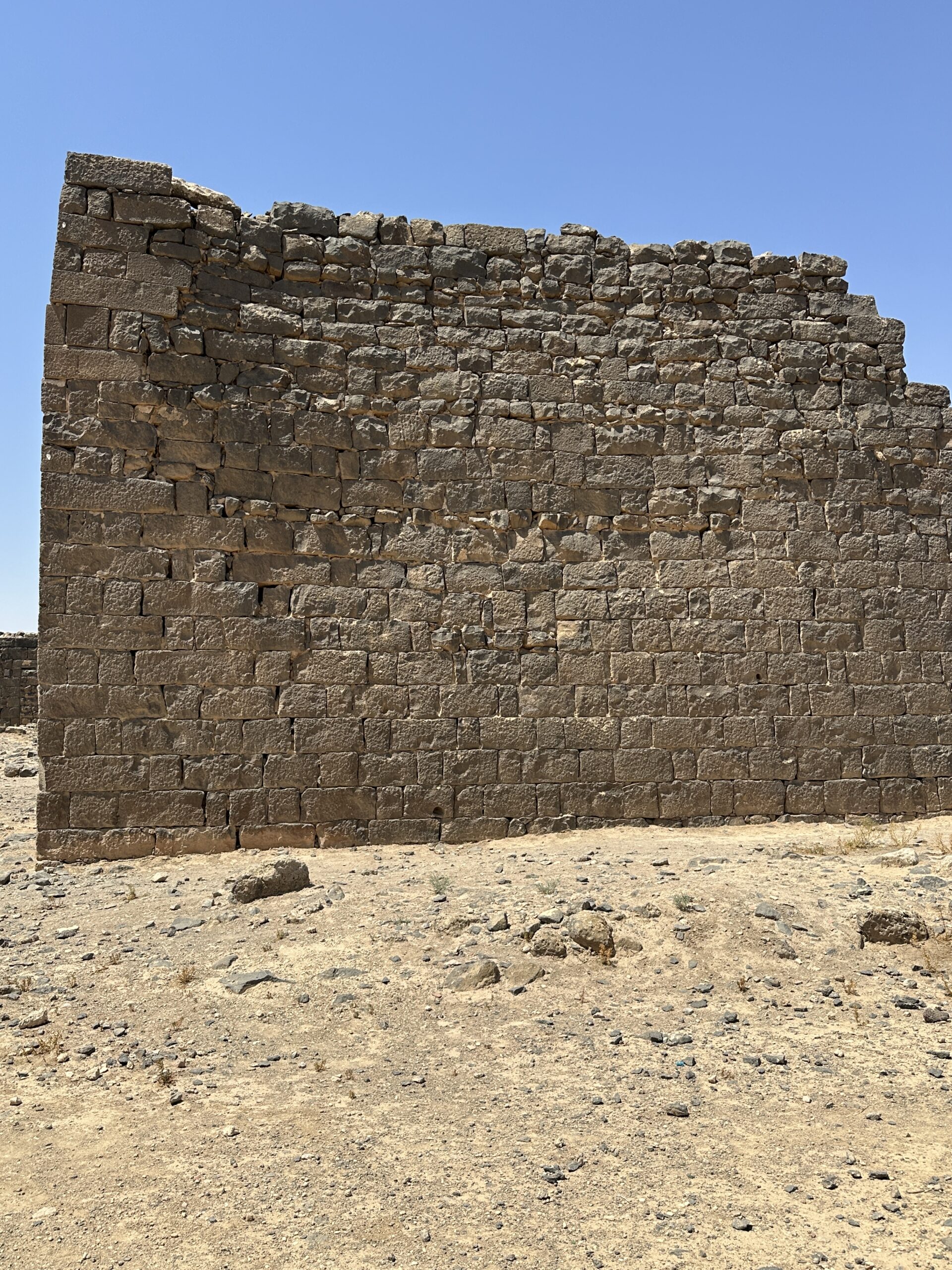
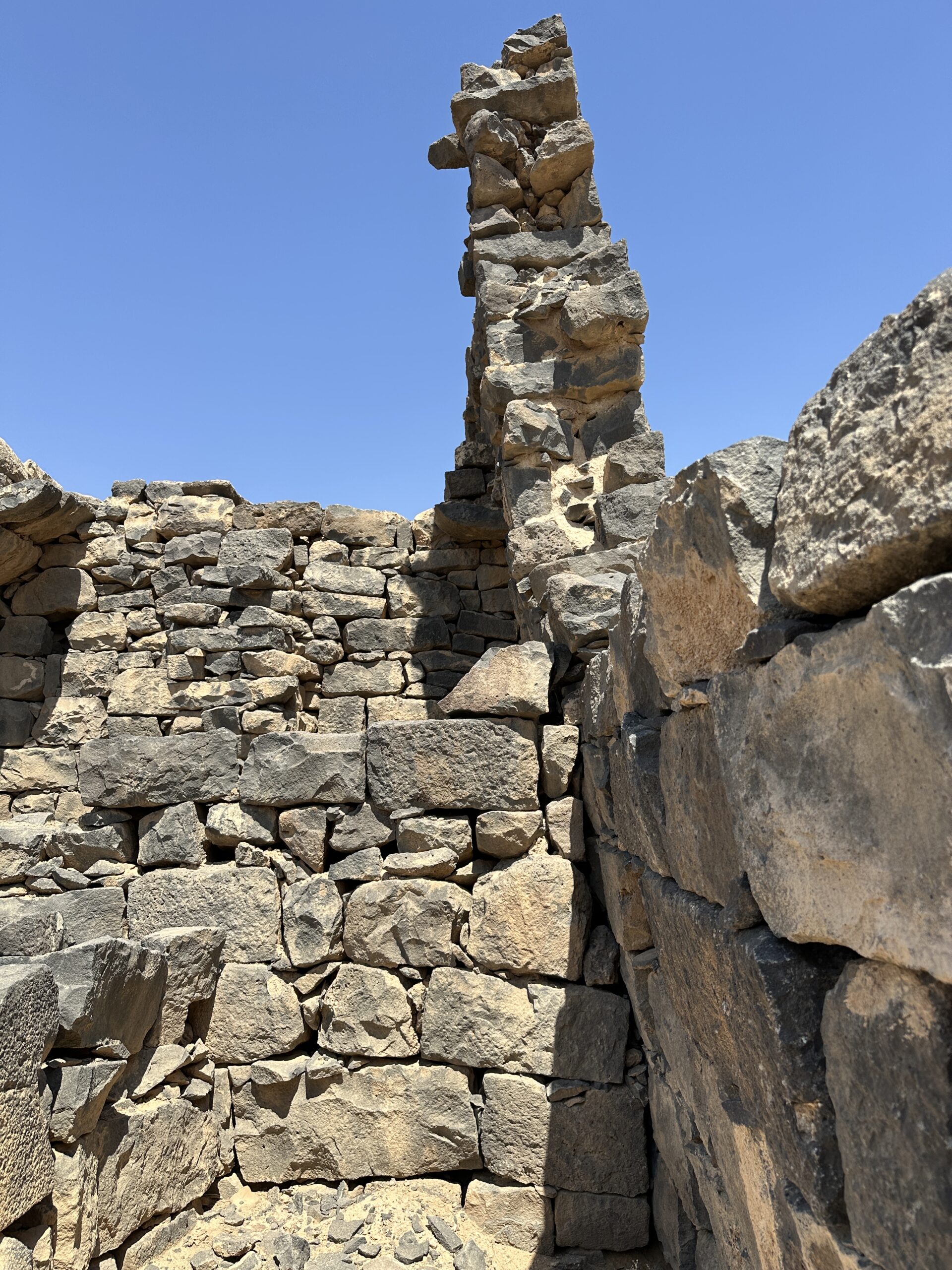
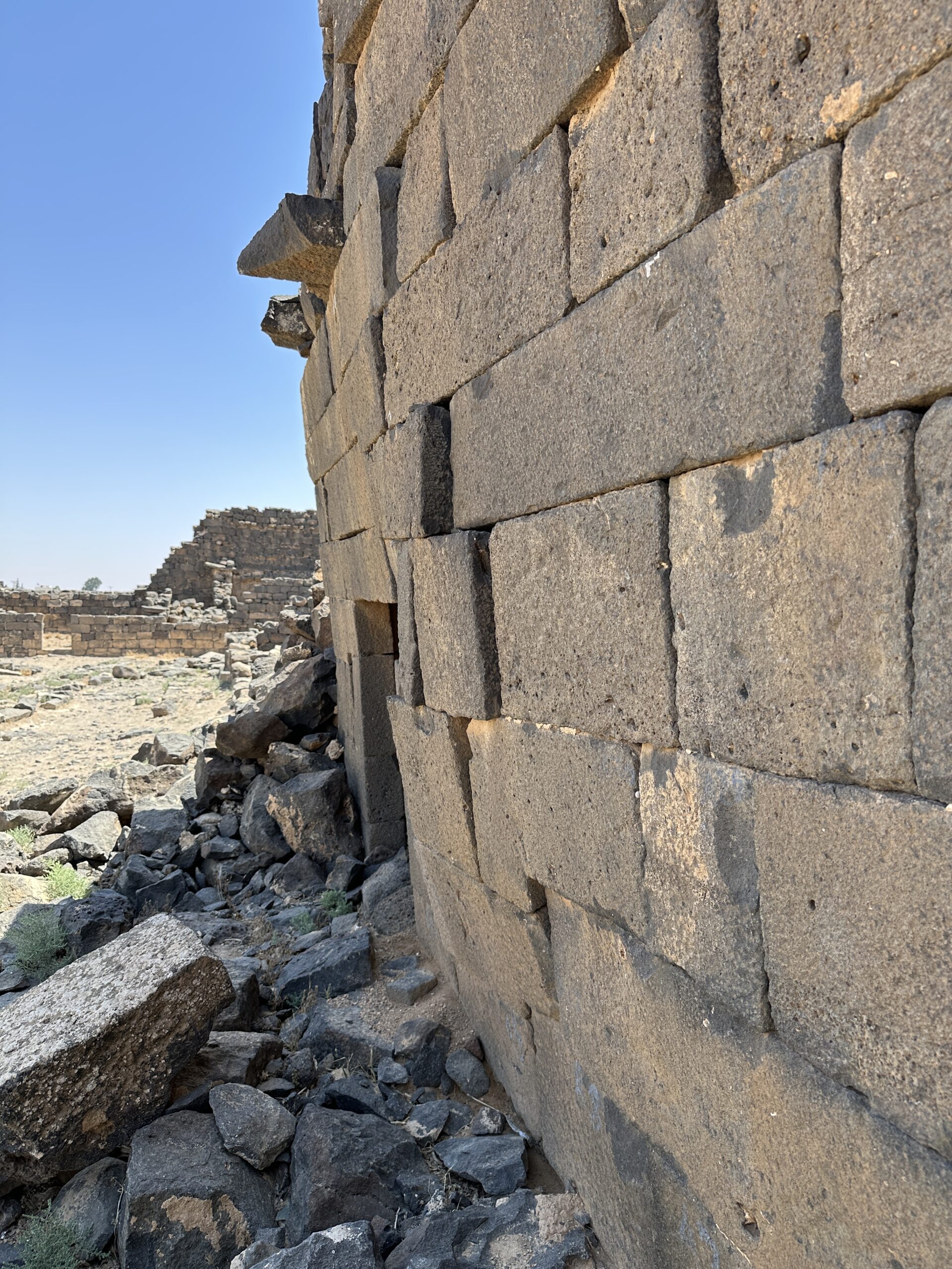
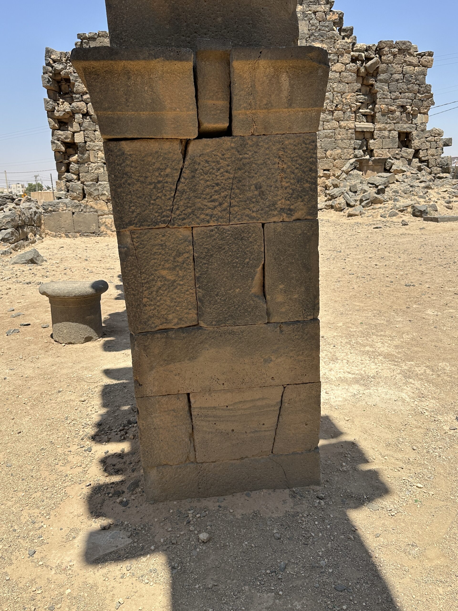
Photo by Jefferson Williams - 24 June 2025 - Tilted and Bulged Wall
at the barracks in Umm al-Jimal - photo by JW
 Tilted and Bulged Wall at the barracks in Umm al-Jimal
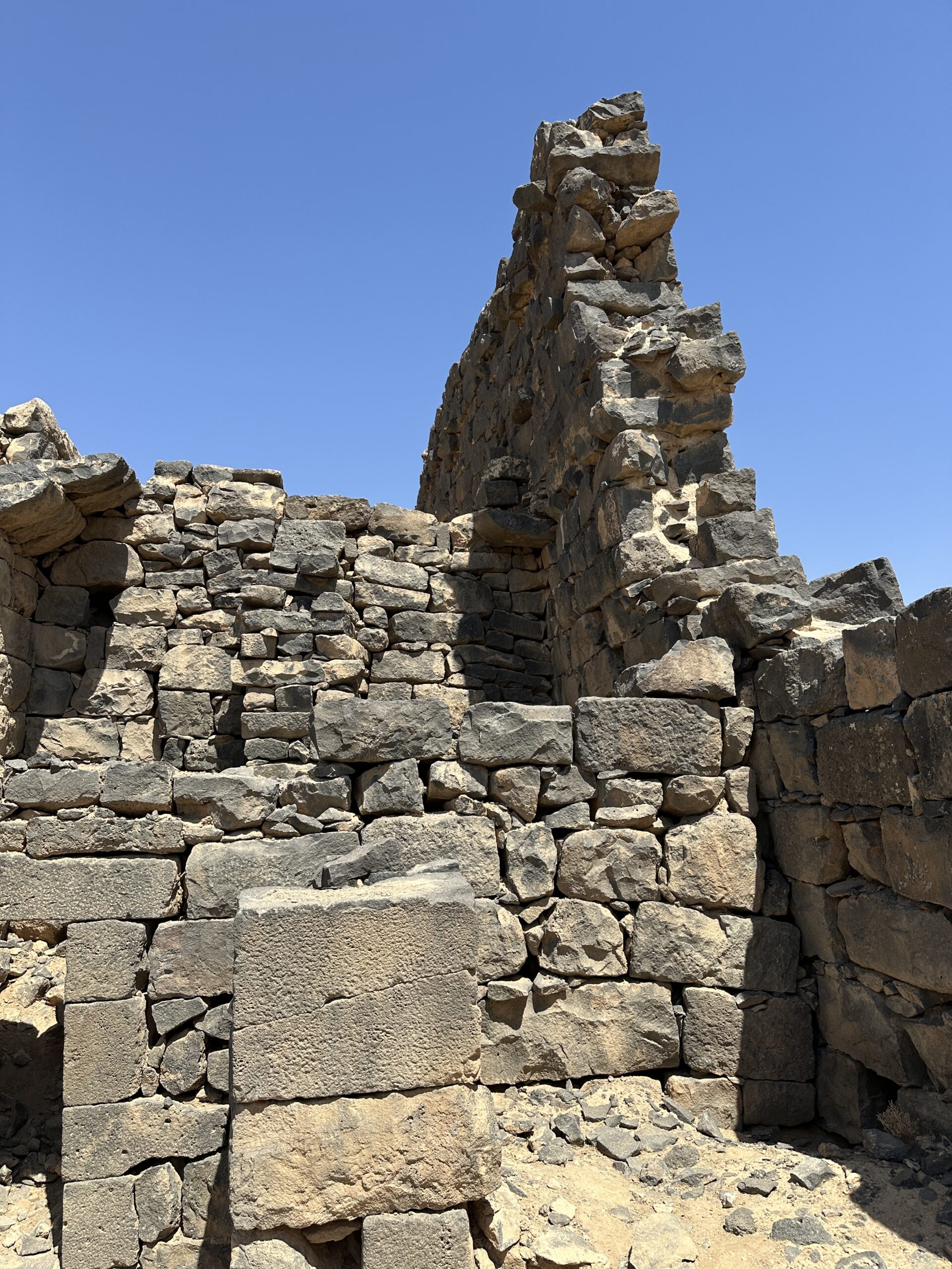
Photo by Jefferson Williams - 24 June 2025 - Strongly tilted wall
at the barracks in Umm al-Jimal - photo by JW
 Stroingly tilted wall at the barracks in Umm al-Jimal
Photo by Jefferson Williams - 24 June 2025 - Strongly tilted wall
at the barracks in Umm al-Jimal - photo by JW
 Stroingly tilted wall at the barracks in Umm al-Jimal
Photo by Jefferson Williams - 24 June 2025 - Strongly tilted wall
at the barracks in Umm al-Jimal - Az = 295 - vertical reference - digital theodolite photo by JW
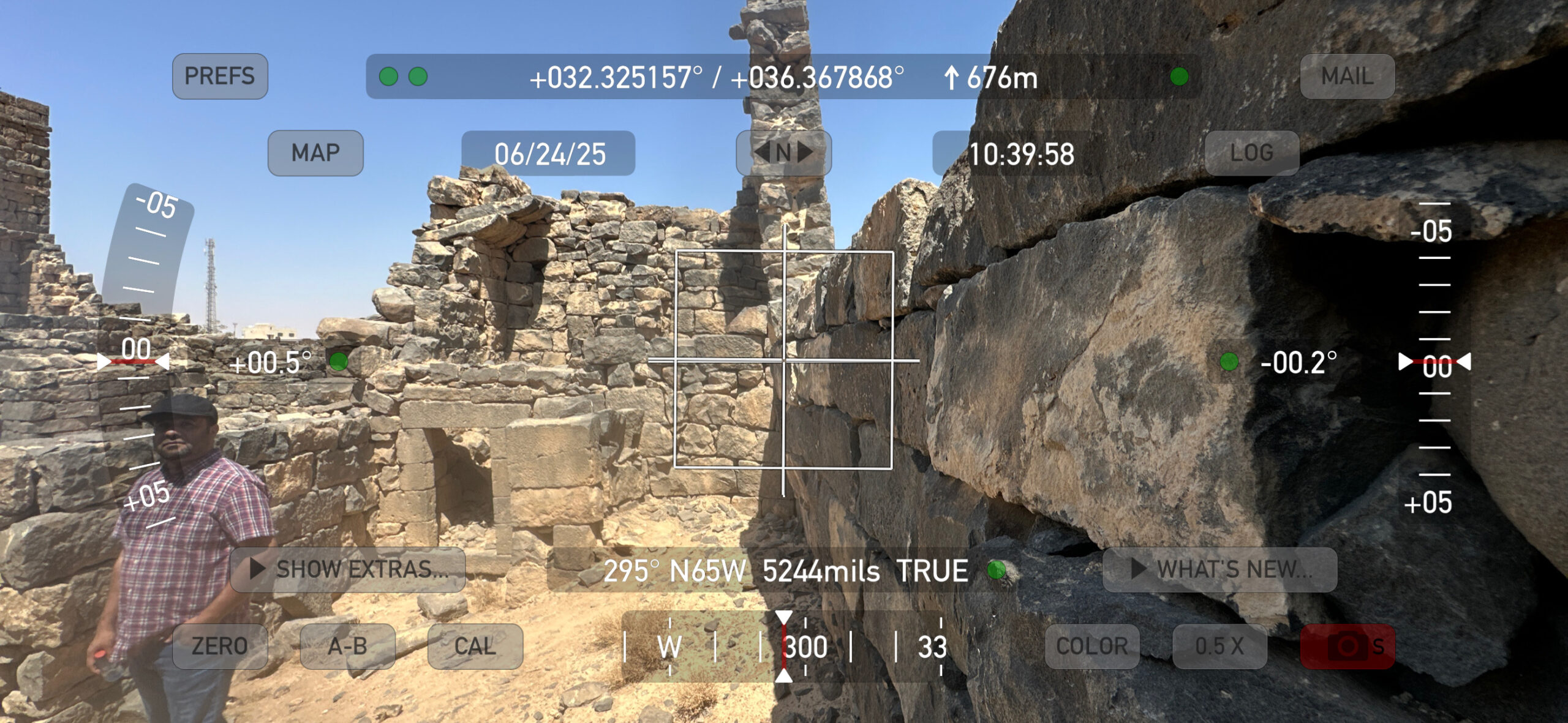 Stroingly tilted wall at the barracks in Umm al-Jimal
Vertical Reference
Az = 295
Digital Theodolite Photo by Jefferson Williams - 24 June 2025 - Strongly tilted wall
at the barracks in Umm al-Jimal - Az = 295 - tilt measure (6 degrees) - digital theodolite photo by JW
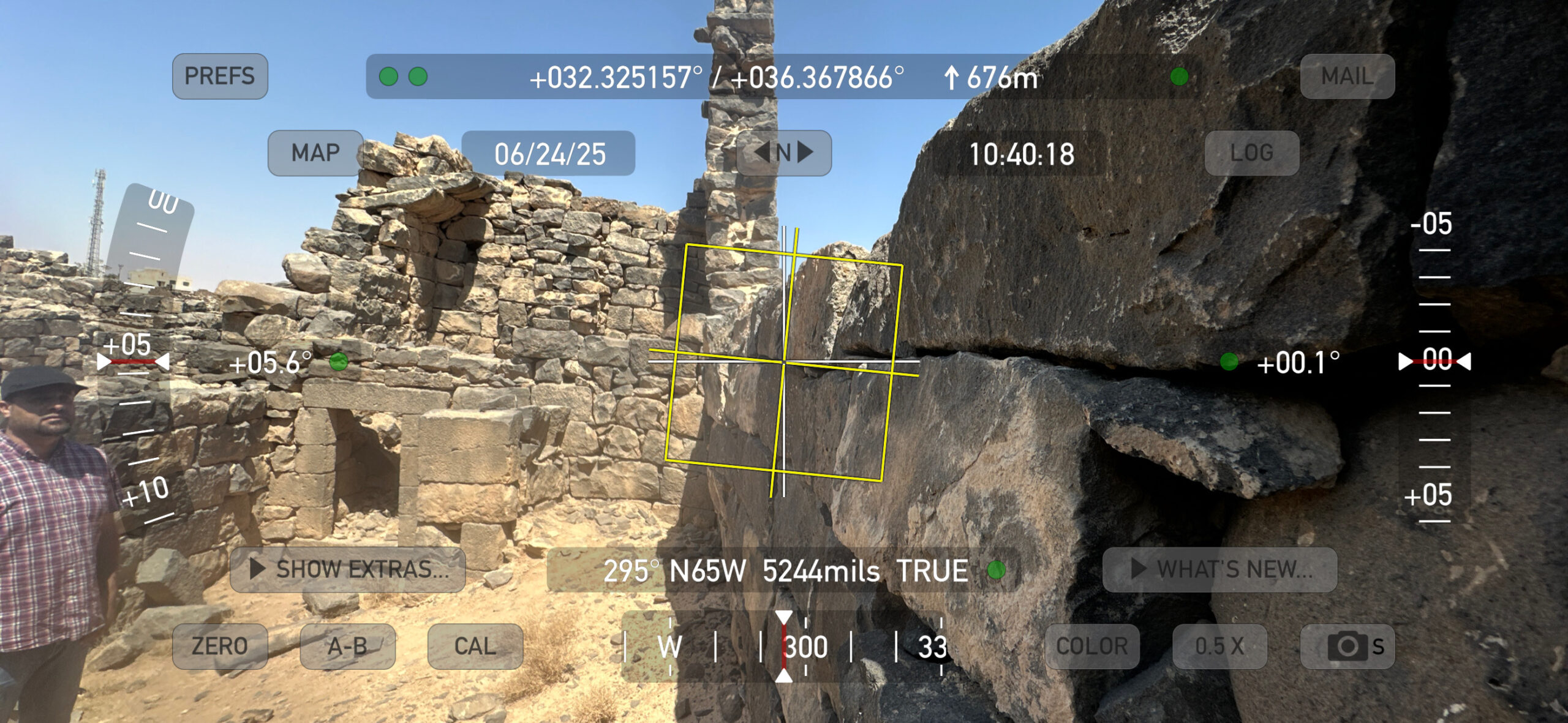 Stroingly tilted wall at the barracks in Umm al-Jimal
Tilt Measure (6 degrees)
Az = 295
Digital Theodolite Photo by Jefferson Williams - 24 June 2025 - Tilted Wall at the barracks
in Umm al-Jimal - Vertical Reference - Az = 21 - Digital Theodolite Photo by JW
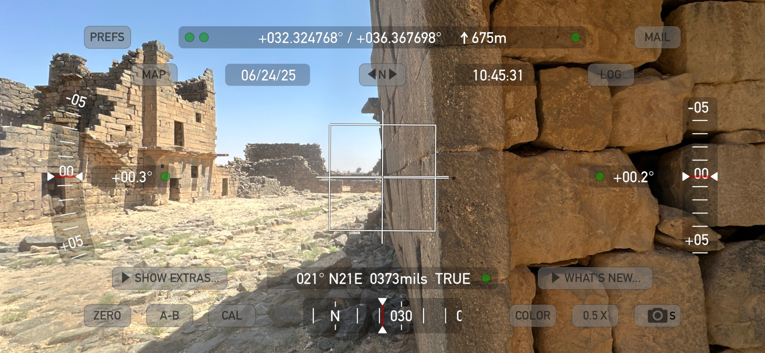 Tilted Wall at the barracks in Umm al-Jimal
Vertical Reference
Az = 21
Digital Theodolite Photo by Jefferson Williams - 24 June 2025 - Tilted Wall in the barracks
in Umm al-Jimal - photo by JW
 Tilted Wall in the barracks in Umm al-Jimal
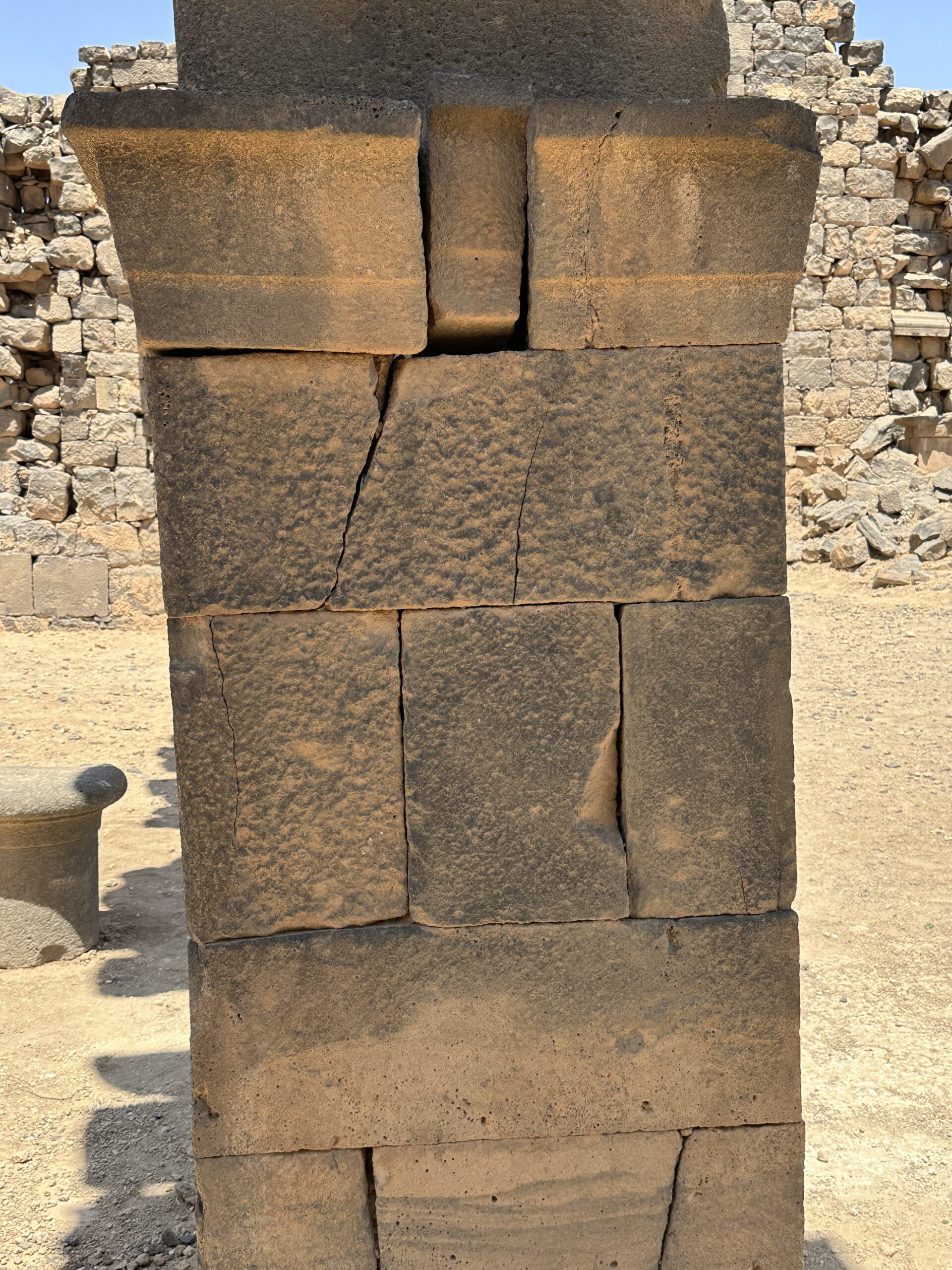
Photo by Jefferson Williams - 24 June 2025 - Bulged Wall in the barracks
in Umm al-Jimal - photo by JW
 Bulged Wall in the barracks in Umm al-Jimal
Photo by Jefferson Williams - 24 June 2025 - Through-going cracks
at the barracks in Umm al-Jimal - photo by JW
 Through-going cracks at the barracks in Umm al-Jimal
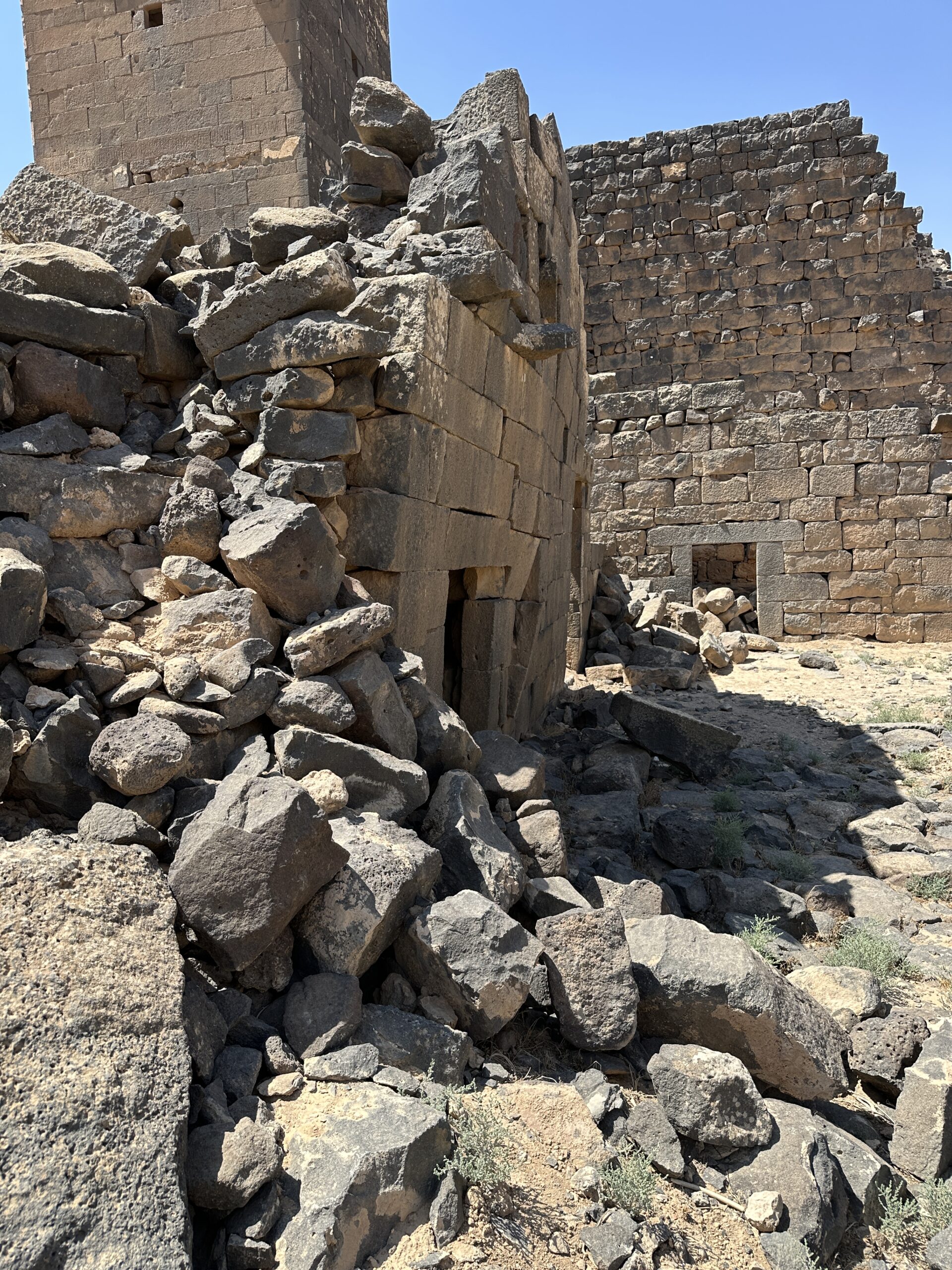
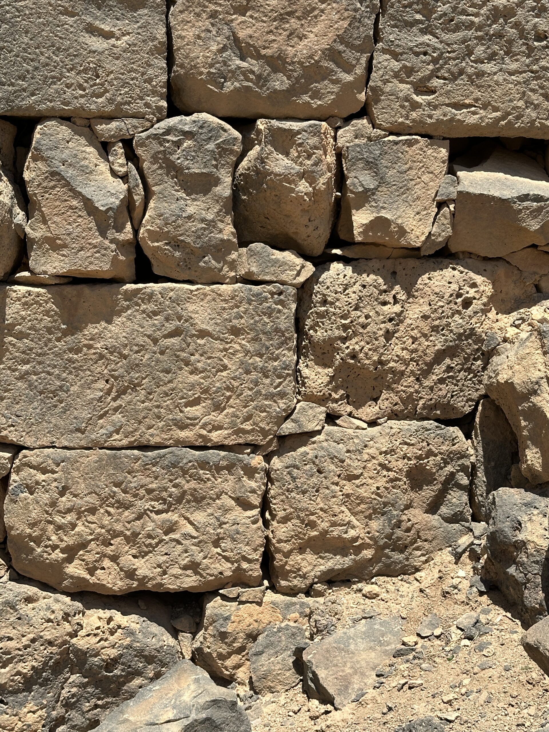
Photo by Jefferson Williams - 24 June 2025 - Displaced and Fractured
Ashlars in the barracks in Umm al-Jimal - photo by JW
 Displaced and Fractured Ashlars in the barracks in Umm al-Jimal
Photo by Jefferson Williams - 24 June 2025 - Displaced and Fractured
Ashlars in the barracks in Umm al-Jimal - photo by JW
 Displaced and Fractured Ashlars in the barracks in Umm al-Jimal
Photo by Jefferson Williams - 24 June 2025
- Plate 2.3 View of the Barracks
from de Vries (2000)
Plate 2.3
Umm al-Jimal: general view of the Barracks
Photo A. Walmsley
de Vries (2000) - Plate 3.1 West facade of the Barracks
from de Vries (2000)
Plate 3.1
Umm al·Jimal: detail of the west facade of the Barracks
Photo A. Walmsley
de Vries (2000) - Figure 3.2 The Western
Tower of the Barracks from Kázmér et al. (2024)
Figure 3.2
Umm al-Jimal. Barracks: view of the western towers from the courtyard. The U-shaped collapse scar of the third-floor wall is a typical mark of seismic shaking. Note the rotated block on the right side of the scar and the twisted wall on the left side of the photo: these are further indicators of lateral loading, twisting, and collapse of walls.
Kázmér et al. (2024) - Figure 3.3 Western Wall
of the Barracks from Kázmér et al. (2024)
Figure 3.3
Umm al-Jimal. Barracks, western wall. Note the twisted walls below the U-shaped collapse feature. The wall closer to the viewer is tilted inwards, the farther one is bulging outwards. These are clear markers of repeated, strong lateral loading
Kázmér et al. (2024) - Longshot of the barracks
in Umm al-Jimal - photo by JW
Longshot of the barracks in Umm al-Jimal
Photo by Jefferson Williams - 24 June 2025 - Park signage of the barracks
in Umm al-Jimal - photo by JW
Park signage of the barracks in Umm al-Jimal
Photo by Jefferson Williams - 24 June 2025 - U shaped cutout at the barracks
in Umm al-Jimal - photo by JW
U shaped cutout at the barracks in Umm al-Jimal
Photo by Jefferson Williams - 24 June 2025 - Reconstructed U shaped
cutout at the barracks in Umm al-Jimal - photo by JW
Reconstructed U shaped cutout at the barracks in Umm al-Jimal
Photo by Jefferson Williams - 24 June 2025 - Reconstructed U shaped
cutout next to U shaped cutout at the barracks in Umm al-Jimal - photo by JW
Reconstructed U shaped cutout next to U shaped cutout at the barracks in Umm al-Jimal
Photo by Jefferson Williams - 24 June 2025 - Tilted and Bulged Wall
at the barracks in Umm al-Jimal - photo by JW
Tilted and Bulged Wall at the barracks in Umm al-Jimal
Photo by Jefferson Williams - 24 June 2025 - Strongly tilted wall
at the barracks in Umm al-Jimal - photo by JW
Stroingly tilted wall at the barracks in Umm al-Jimal
Photo by Jefferson Williams - 24 June 2025 - Strongly tilted wall
at the barracks in Umm al-Jimal - photo by JW
Stroingly tilted wall at the barracks in Umm al-Jimal
Photo by Jefferson Williams - 24 June 2025 - Strongly tilted wall
at the barracks in Umm al-Jimal - Az = 295 - vertical reference - digital theodolite photo by JW
Stroingly tilted wall at the barracks in Umm al-Jimal
Vertical Reference
Az = 295
Digital Theodolite Photo by Jefferson Williams - 24 June 2025 - Strongly tilted wall
at the barracks in Umm al-Jimal - Az = 295 - tilt measure (6 degrees) - digital theodolite photo by JW
Stroingly tilted wall at the barracks in Umm al-Jimal
Tilt Measure (6 degrees)
Az = 295
Digital Theodolite Photo by Jefferson Williams - 24 June 2025 - Tilted Wall at the barracks
in Umm al-Jimal - Vertical Reference - Az = 21 - Digital Theodolite Photo by JW
Tilted Wall at the barracks in Umm al-Jimal
Vertical Reference
Az = 21
Digital Theodolite Photo by Jefferson Williams - 24 June 2025 - Tilted Wall in the barracks
in Umm al-Jimal - photo by JW
Tilted Wall in the barracks in Umm al-Jimal
Photo by Jefferson Williams - 24 June 2025 - Bulged Wall in the barracks
in Umm al-Jimal - photo by JW
Bulged Wall in the barracks in Umm al-Jimal
Photo by Jefferson Williams - 24 June 2025 - Through-going cracks
at the barracks in Umm al-Jimal - photo by JW
Through-going cracks at the barracks in Umm al-Jimal
Photo by Jefferson Williams - 24 June 2025 - Displaced and Fractured
Ashlars in the barracks in Umm al-Jimal - photo by JW
Displaced and Fractured Ashlars in the barracks in Umm al-Jimal
Photo by Jefferson Williams - 24 June 2025 - Displaced and Fractured
Ashlars in the barracks in Umm al-Jimal - photo by JW
Displaced and Fractured Ashlars in the barracks in Umm al-Jimal
Photo by Jefferson Williams - 24 June 2025
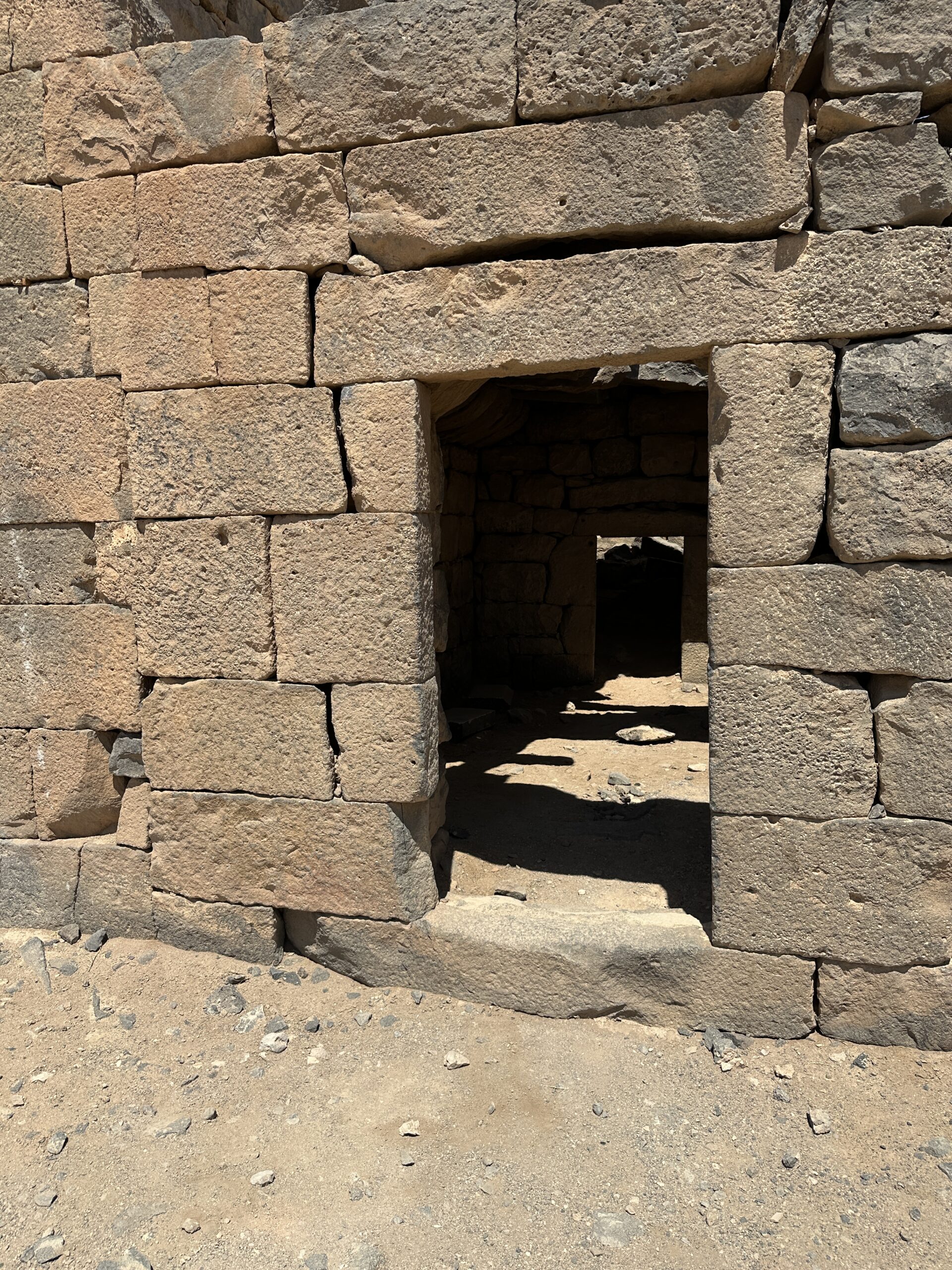
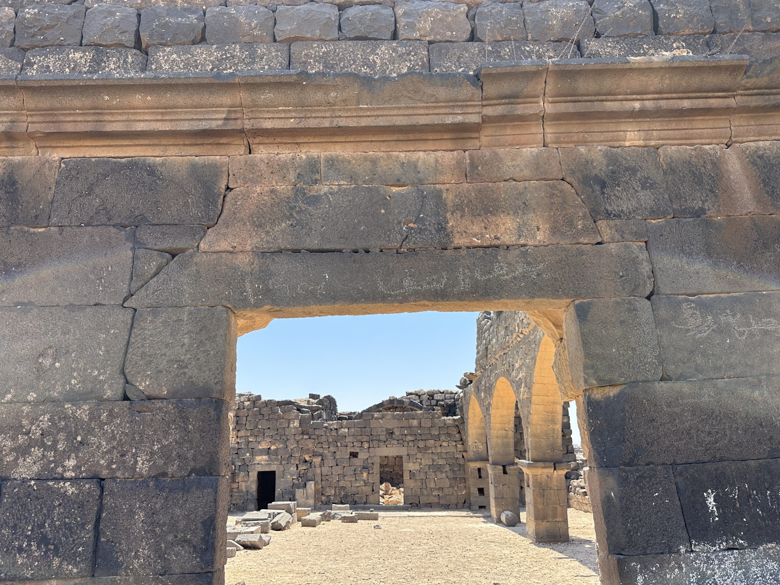
- Longshot of the four
arches in the West Church in Umm al-Jimal - photo by JW
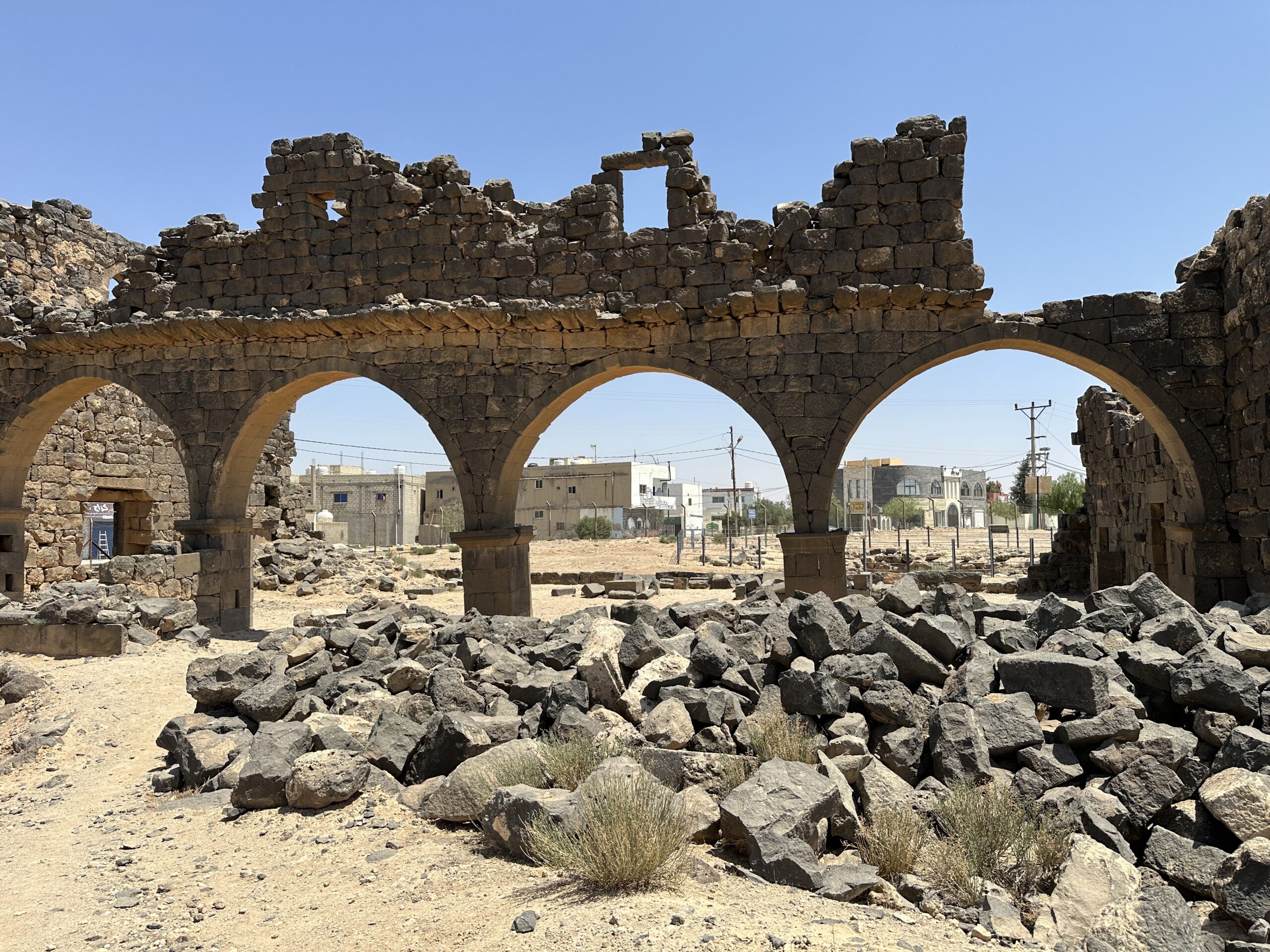 Longshot of the four arches in the West Church in Umm al-Jimal
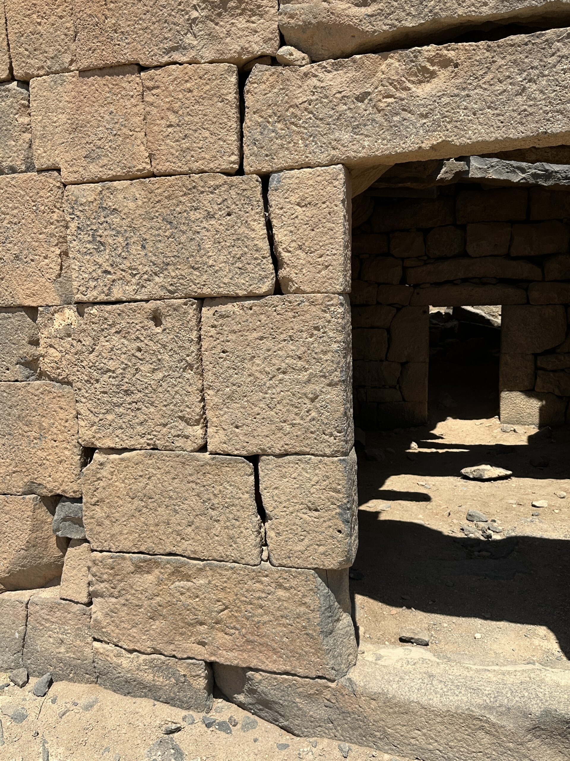
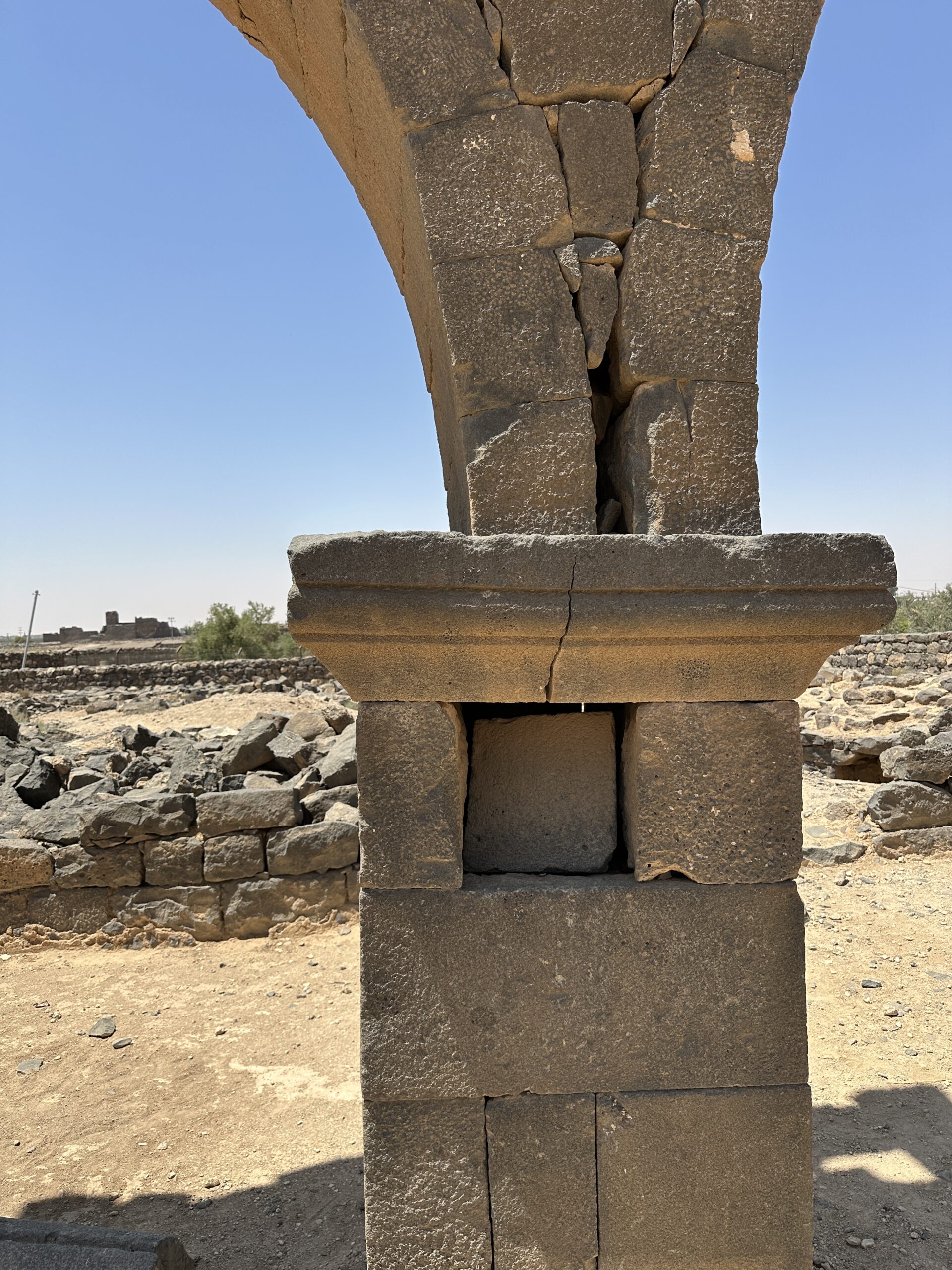
Photo by Jefferson Williams - 24 June 2025 - Arch Impost Damage
for one of the four arches in the West Church in Umm al-Jimal - photo by JW
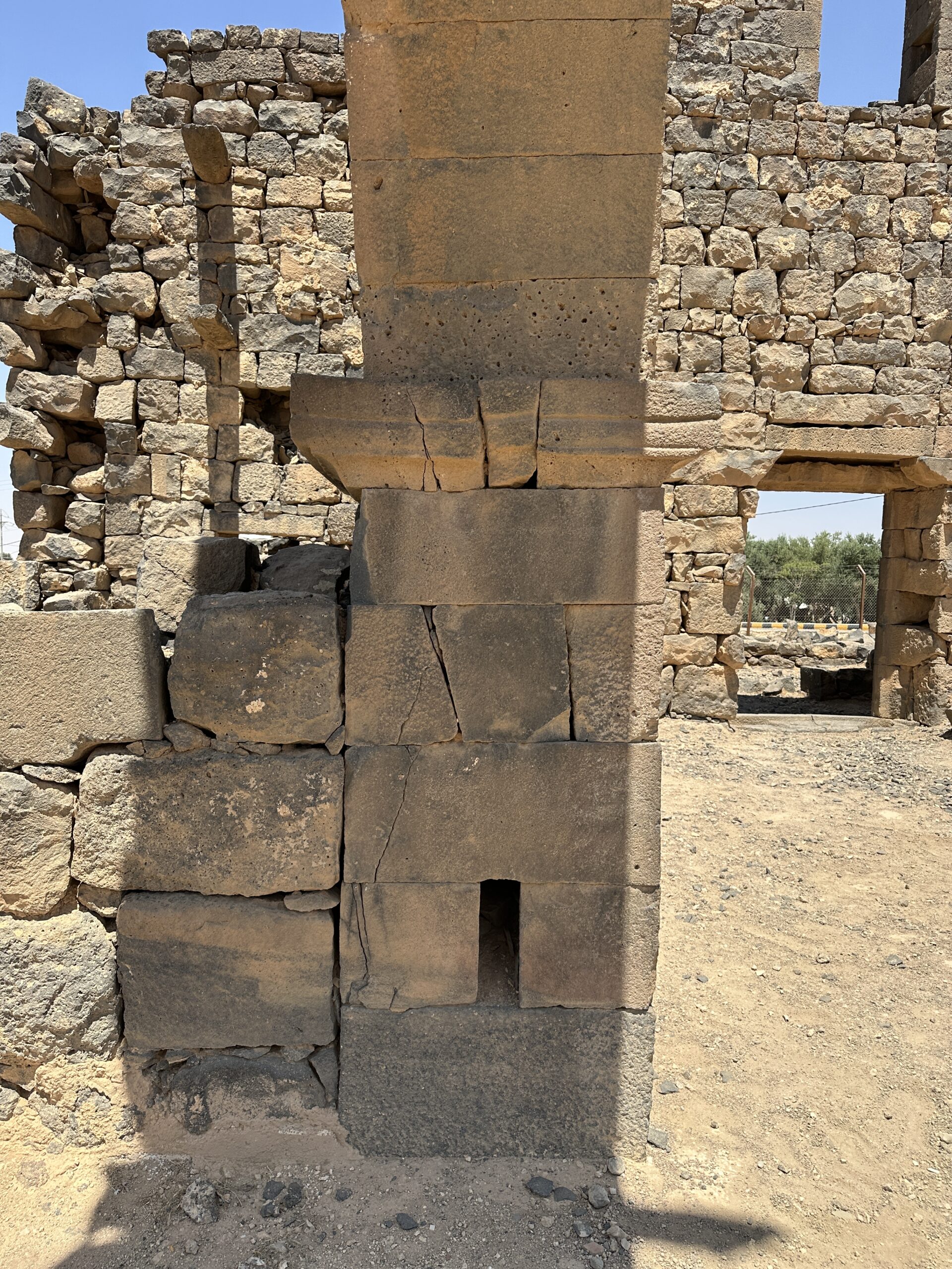 Arch Impost Damage for one of the four arches in the West Church in Umm al-Jimal
Photo by Jefferson Williams - 24 June 2025 - Arch Impost Damage
for one of the four arches in the West Church in Umm al-Jimal - photo by JW
 Arch Impost Damage for one of the four arches in the West Church in Umm al-Jimal
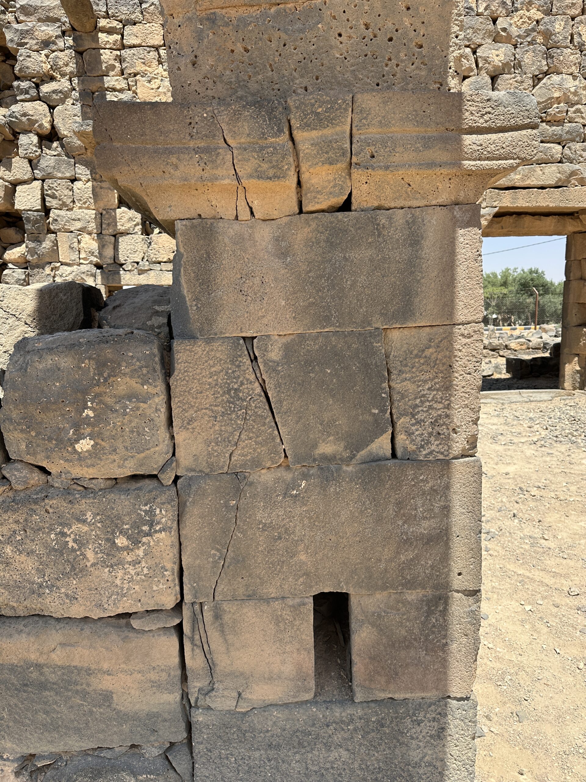
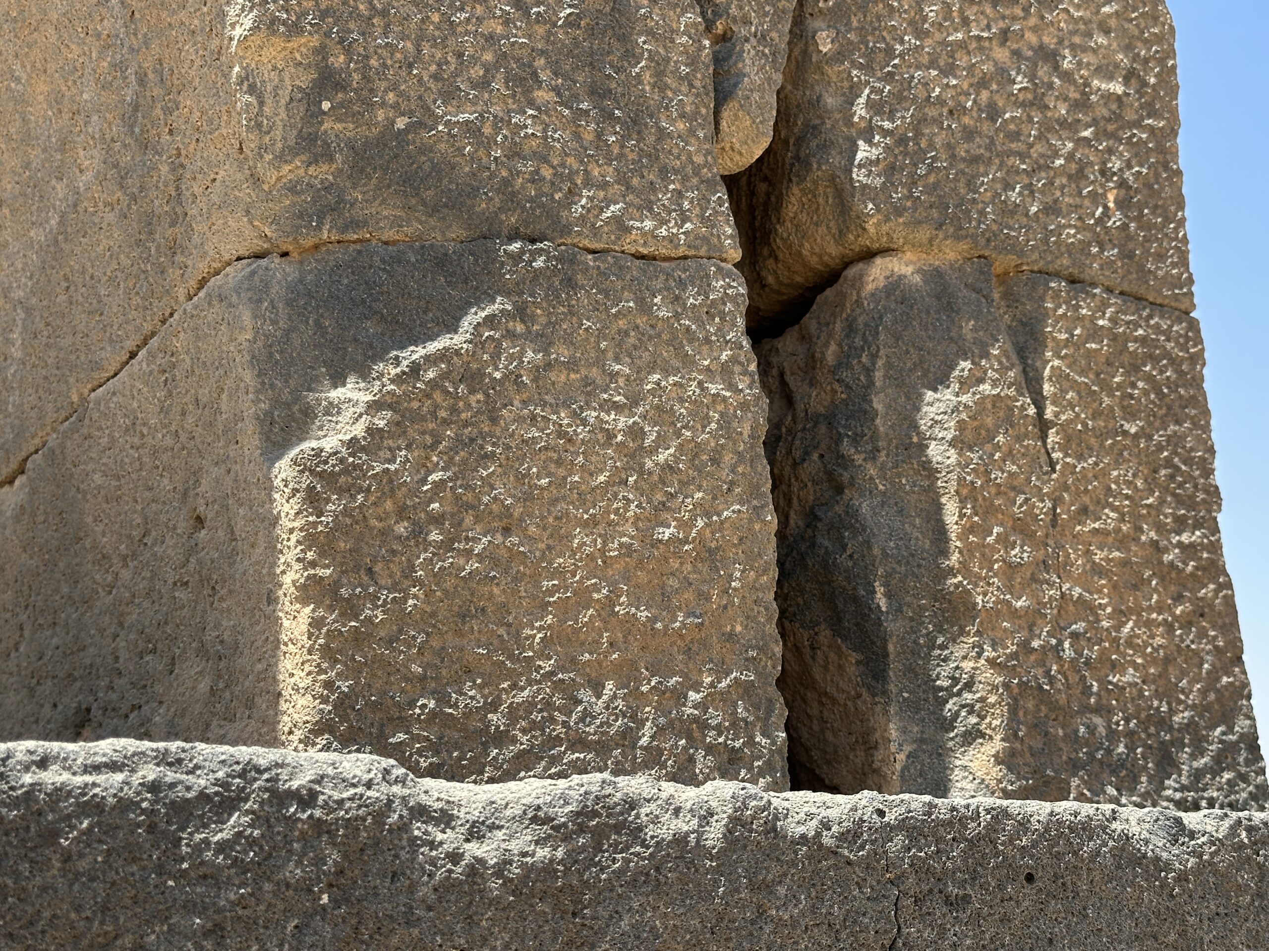
Photo by Jefferson Williams - 24 June 2025 - Arch Impost Damage
for one of the four arches in the West Church in Umm al-Jimal - closeup photo by JW
 Closeup of Arch Impost Damage for one of the four arches in the West Church in Umm al-Jimal
Photo by Jefferson Williams - 24 June 2025 - Arch Impost Damage
for one of the four arches in the West Church in Umm al-Jimal - photo by JW
 Arch Impost Damage for one of the four arches in the West Church in Umm al-Jimal
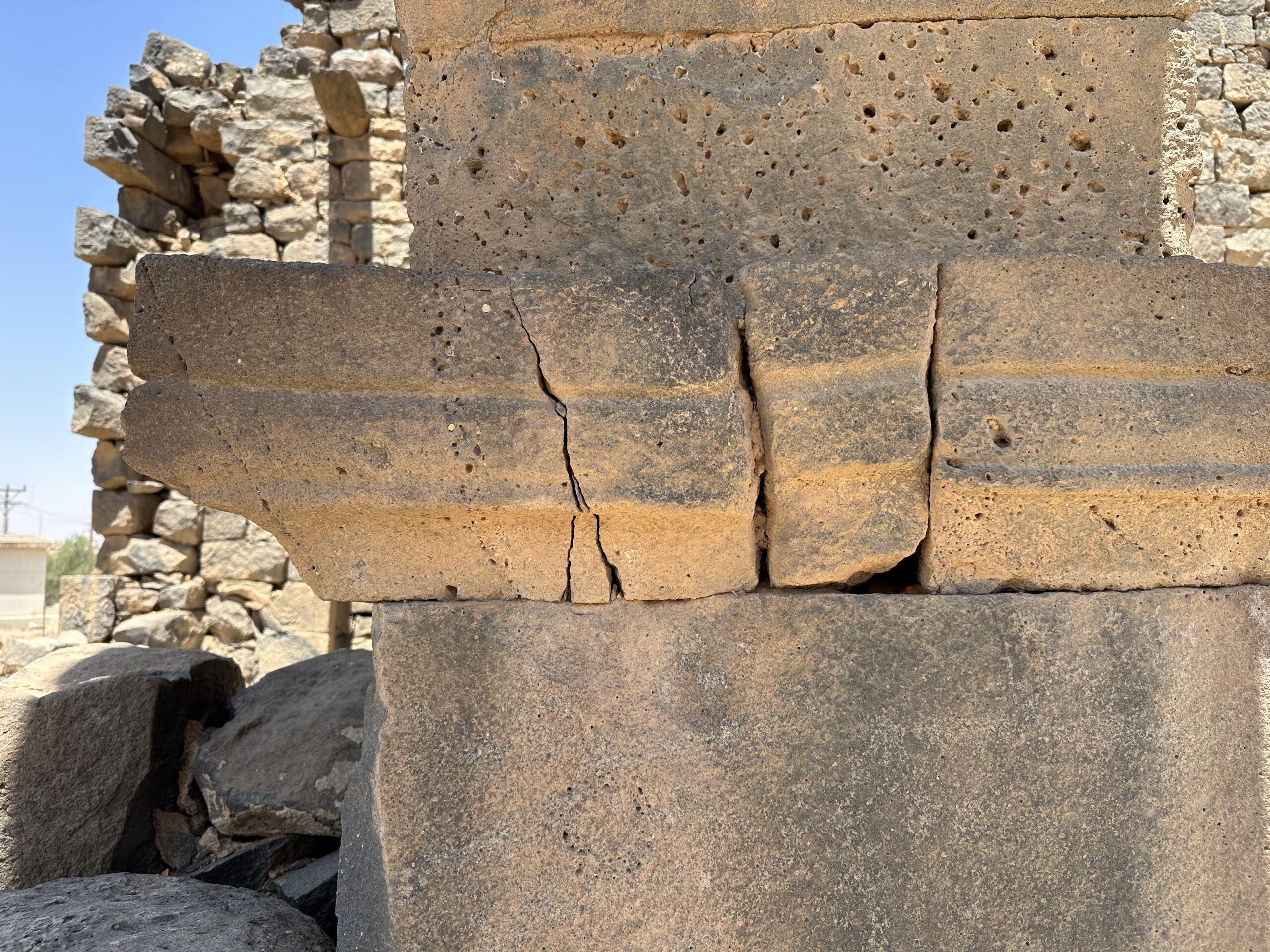
Photo by Jefferson Williams - 24 June 2025 - Arch Impost Damage
for one of the four arches in the West Church in Umm al-Jimal - closeup photo by JW
 Closeup of Arch Impost Damage for one of the four arches in the West Church in Umm al-Jimal
Photo by Jefferson Williams - 24 June 2025 - Arch Impost Damage
for one of the four arches in the West Church in Umm al-Jimal - photo by JW
 Arch Impost Damage for one of the four arches in the West Church in Umm al-Jimal
Photo by Jefferson Williams - 24 June 2025 - Arch Impost Damage
for one of the four arches in the West Church in Umm al-Jimal - closeup photo by JW
Closeup of Arch Impost Damage for one of the four arches in the West Church in Umm al-Jimal
Photo by Jefferson Williams - 24 June 2025 - Spalled corners in
the West Church in Umm al-Jimal - photo by JW
 Splalled corners in the West Church in Umm al-Jimal
Photo by Jefferson Williams - 24 June 2025 - Cracks in the West
Church in Umm al-Jimal - photo by JW
 Cracks in the West Church in Umm al-Jimal
Photo by Jefferson Williams - 24 June 2025 - Lintel Stress Damage
in the West Church in Umm al-Jimal - photo by JW
 Lintel Stress Damage in the West Church in Umm al-Jimal
Photo by Jefferson Williams - 24 June 2025 - View of subsurface
in vicinity of the West Church in Umm al-Jimal - photo by JW
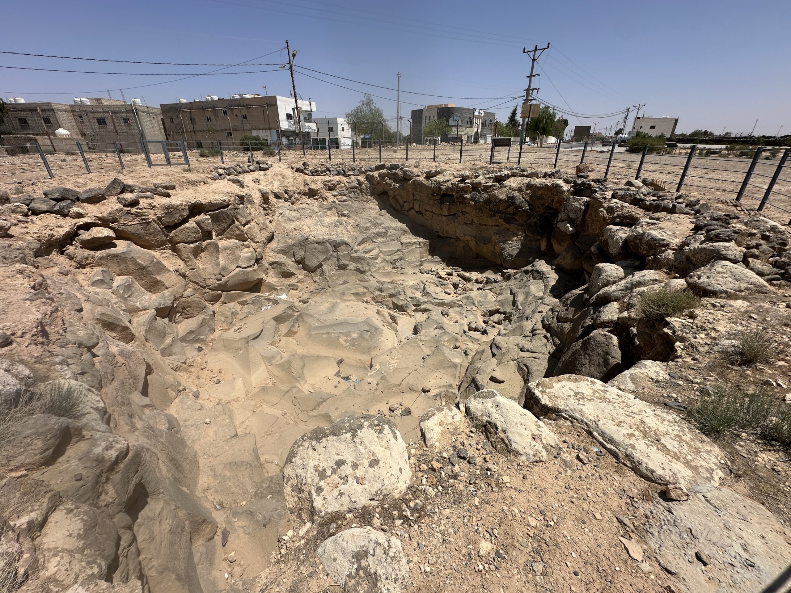 View of subsurface in vicinity of the West Church in Umm al-Jimal
Photo by Jefferson Williams - 24 June 2025
- Longshot of the four
arches in the West Church in Umm al-Jimal - photo by JW
Longshot of the four arches in the West Church in Umm al-Jimal
Photo by Jefferson Williams - 24 June 2025 - Arch Impost Damage
for one of the four arches in the West Church in Umm al-Jimal - photo by JW
Arch Impost Damage for one of the four arches in the West Church in Umm al-Jimal
Photo by Jefferson Williams - 24 June 2025 - Arch Impost Damage
for one of the four arches in the West Church in Umm al-Jimal - photo by JW
Arch Impost Damage for one of the four arches in the West Church in Umm al-Jimal
Photo by Jefferson Williams - 24 June 2025 - Arch Impost Damage
for one of the four arches in the West Church in Umm al-Jimal - closeup photo by JW
Closeup of Arch Impost Damage for one of the four arches in the West Church in Umm al-Jimal
Photo by Jefferson Williams - 24 June 2025 - Arch Impost Damage
for one of the four arches in the West Church in Umm al-Jimal - photo by JW
Arch Impost Damage for one of the four arches in the West Church in Umm al-Jimal
Photo by Jefferson Williams - 24 June 2025 - Arch Impost Damage
for one of the four arches in the West Church in Umm al-Jimal - closeup photo by JW
Closeup of Arch Impost Damage for one of the four arches in the West Church in Umm al-Jimal
Photo by Jefferson Williams - 24 June 2025 - Spalled corners in
the West Church in Umm al-Jimal - photo by JW
Splalled corners in the West Church in Umm al-Jimal
Photo by Jefferson Williams - 24 June 2025 - Cracks in the West
Church in Umm al-Jimal - photo by JW
Cracks in the West Church in Umm al-Jimal
Photo by Jefferson Williams - 24 June 2025 - Lintel Stress Damage
in the West Church in Umm al-Jimal - photo by JW
Lintel Stress Damage in the West Church in Umm al-Jimal
Photo by Jefferson Williams - 24 June 2025 - View of subsurface
in vicinity of the West Church in Umm al-Jimal - photo by JW
View of subsurface in vicinity of the West Church in Umm al-Jimal
Photo by Jefferson Williams - 24 June 2025
| Effect | Location | Image(s) | Description |
|---|---|---|---|
|
Barracks
Fig. 4 Plan of the castellum Drawn by Bert de Vries de Vries (1993) |
Plate 2.3 Umm al-Jimal: general view of the Barracks Photo A. Walmsley de Vries (2000)
Plate 3.1Umm al·Jimal: detail of the west facade of the Barracks Photo A. Walmsley de Vries (2000)
Figure 3.2Umm al-Jimal. Barracks: view of the western towers from the courtyard. The U-shaped collapse scar of the third-floor wall is a typical mark of seismic shaking. Note the rotated block on the right side of the scar and the twisted wall on the left side of the photo: these are further indicators of lateral loading, twisting, and collapse of walls. Kázmér et al. (2024)
Figure 3.3Umm al-Jimal. Barracks, western wall. Note the twisted walls below the U-shaped collapse feature. The wall closer to the viewer is tilted inwards, the farther one is bulging outwards. These are clear markers of repeated, strong lateral loading Kázmér et al. (2024) |
|
|
Northeast Church
Figure 11.7
Preliminary Plan of the Northeast Church, showing excavation trenches (drawing: H. Verkuyl; Figure: E. Osinga) click on image to open in a new tab Lichtenberger and Raja (2025) |
|
| Effect | Location | Image(s) | Description |
|---|---|---|---|
|
Barracks
Fig. 4 Plan of the castellum Drawn by Bert de Vries de Vries (1993) |
Plate 2.3 Umm al-Jimal: general view of the Barracks Photo A. Walmsley de Vries (2000)
Plate 3.1Umm al·Jimal: detail of the west facade of the Barracks Photo A. Walmsley de Vries (2000)
Figure 3.2Umm al-Jimal. Barracks: view of the western towers from the courtyard. The U-shaped collapse scar of the third-floor wall is a typical mark of seismic shaking. Note the rotated block on the right side of the scar and the twisted wall on the left side of the photo: these are further indicators of lateral loading, twisting, and collapse of walls. Kázmér et al. (2024)
Figure 3.3Umm al-Jimal. Barracks, western wall. Note the twisted walls below the U-shaped collapse feature. The wall closer to the viewer is tilted inwards, the farther one is bulging outwards. These are clear markers of repeated, strong lateral loading Kázmér et al. (2024) |
|
|
the Roman Temple (erroneously named the “Nabataean Temple” by Howard Butler), which was later converted into a domestic structure, known as House 49
Figure 11.6
Plan of the Roman Temple, showing excavation trenches (drawing: J. Yeats; Figure: E. Osinga) click on image to open in a new tab Lichtenberger and Raja (2025) |
|
|
|
Numerianos Church complex
Figure 11.8
Preliminary Plan of the Numerianos Church, showing excavation trenches (drawing: H.C. Butler and B. de Vries; Figure: E. Osinga) click on image to open in a new tab Lichtenberger and Raja (2025) |
|
|
|
House XIV
Figure 11.9
Sketch plan of House XIV, showing trench N.1 (drawing: H. Verkuyl; figure: E. Osinga) click on image to open in a new tab Lichtenberger and Raja (2025) |
|
|
|
House 119
Figure 11.10
Plan of House 119, showing excavation trenches (drawing: D. Winnail; figure: E. Osinga) click on image to open in a new tab Lichtenberger and Raja (2025) |
|
|
|
House XVII–XVIII
Figure 11.11
Plan of the ground floor of House XVII-XVIII, showing excavation trenches (drawing: M. al-Bataineh; figure: E. Osinga) click on image to open in a new tab Lichtenberger and Raja (2025) |
|
- Earthquake Archeological Effects chart
of Rodríguez-Pascua et al (2013: 221-224)
 Earthquake Archeological Effects (EAE)
Rodríguez-Pascua et al (2013: 221-224)
| Effect | Location | Image(s) | Description | Intensity |
|---|---|---|---|---|
|
Barracks
Fig. 4 Plan of the castellum Drawn by Bert de Vries de Vries (1993) |
Plate 2.3 Umm al-Jimal: general view of the Barracks Photo A. Walmsley de Vries (2000)
Plate 3.1Umm al·Jimal: detail of the west facade of the Barracks Photo A. Walmsley de Vries (2000)
Figure 3.2Umm al-Jimal. Barracks: view of the western towers from the courtyard. The U-shaped collapse scar of the third-floor wall is a typical mark of seismic shaking. Note the rotated block on the right side of the scar and the twisted wall on the left side of the photo: these are further indicators of lateral loading, twisting, and collapse of walls. Kázmér et al. (2024)
Figure 3.3Umm al-Jimal. Barracks, western wall. Note the twisted walls below the U-shaped collapse feature. The wall closer to the viewer is tilted inwards, the farther one is bulging outwards. These are clear markers of repeated, strong lateral loading Kázmér et al. (2024) |
|
|
|
Northeast Church
Figure 11.7
Preliminary Plan of the Northeast Church, showing excavation trenches (drawing: H. Verkuyl; Figure: E. Osinga) click on image to open in a new tab Lichtenberger and Raja (2025) |
|
|
- Earthquake Archeological Effects chart
of Rodríguez-Pascua et al (2013: 221-224)
Earthquake Archeological Effects (EAE)
Rodríguez-Pascua et al (2013: 221-224)
| Effect | Location | Image(s) | Description | Intensity |
|---|---|---|---|---|
|
Barracks
Fig. 4 Plan of the castellum Drawn by Bert de Vries de Vries (1993) |
Plate 2.3 Umm al-Jimal: general view of the Barracks Photo A. Walmsley de Vries (2000)
Plate 3.1Umm al·Jimal: detail of the west facade of the Barracks Photo A. Walmsley de Vries (2000)
Figure 3.2Umm al-Jimal. Barracks: view of the western towers from the courtyard. The U-shaped collapse scar of the third-floor wall is a typical mark of seismic shaking. Note the rotated block on the right side of the scar and the twisted wall on the left side of the photo: these are further indicators of lateral loading, twisting, and collapse of walls. Kázmér et al. (2024)
Figure 3.3Umm al-Jimal. Barracks, western wall. Note the twisted walls below the U-shaped collapse feature. The wall closer to the viewer is tilted inwards, the farther one is bulging outwards. These are clear markers of repeated, strong lateral loading Kázmér et al. (2024) |
|
|
|
the Roman Temple (erroneously named the “Nabataean Temple” by Howard Butler), which was later converted into a domestic structure, known as House 49
Figure 11.6
Plan of the Roman Temple, showing excavation trenches (drawing: J. Yeats; Figure: E. Osinga) click on image to open in a new tab Lichtenberger and Raja (2025) |
|
|
|
|
Numerianos Church complex
Figure 11.8
Preliminary Plan of the Numerianos Church, showing excavation trenches (drawing: H.C. Butler and B. de Vries; Figure: E. Osinga) click on image to open in a new tab Lichtenberger and Raja (2025) |
|
|
|
|
House XIV
Figure 11.9
Sketch plan of House XIV, showing trench N.1 (drawing: H. Verkuyl; figure: E. Osinga) click on image to open in a new tab Lichtenberger and Raja (2025) |
|
|
|
|
House 119
Figure 11.10
Plan of House 119, showing excavation trenches (drawing: D. Winnail; figure: E. Osinga) click on image to open in a new tab Lichtenberger and Raja (2025) |
|
|
|
|
House XVII–XVIII
Figure 11.11
Plan of the ground floor of House XVII-XVIII, showing excavation trenches (drawing: M. al-Bataineh; figure: E. Osinga) click on image to open in a new tab Lichtenberger and Raja (2025) |
|
|