| Stratum |
Period |
Date Range |
Description |
| XI |
Late Byzantine |
6th century [?]–middle of 7th century CE |
Description
The beginning of settlement at the site was exposed in limited sections, primarily due to their great depth
(up to 3 m below surface). The limited number of buildings from this period is probably due to their continued use
in the next stratum. Part of a building that was constructed on virgin soil was exposed in Area F. The date ascribed
to the building is likely to represent the time it went out of use, possibly in the middle of the seventh century
CE. Sections of a building, apparently the southern wing which was dismantled and its stones robbed in the Abbasid
period (below), were excavated in Area J. Since its northern part was removed in the 1950s, it is difficult to
gain a coherent plan. The excavated part indicates that the building was oriented east–west and had at least
three lengthwise spaces that were divided into rooms. A foundation in the western part was surmounted with a
row of pillars, standing a single course high. A marble column found nearby probably stood on one of the pillars.
The thick, gray-plastered floors of the rooms were adapted to the natural topography, hence their level was not
uniform; the western floors were c. 1 m higher than the eastern ones. A few remains, dating to the Byzantine or
Umayyad periods, which probably belonged to one of the early phases of the building, were found below the floors.
The building was covered with a thick layer of fill that contained a large quantity of roof tiles and pieces of
marble pavement in a variety of shades, including a chancel screen fragment bearing a carved cross (Fig. 2) and a
gilded, glass tessera. It seems the public building was connected to a church, which was probably built in the
Byzantine period and used until the Abbasid period, perhaps in a different capacity, thereafter dismantled and
covered over. Throughout the site, numerous architectural elements, mainly of marble and probably associated with
the church, were found in secondary use in later strata or fills. Noteworthy among them were marble chancel posts,
columns and capitals, as well as a fragment of a Late Roman Ware, Type 3 vessel and the base of a bowl adorned with a stamped cross.
|
| X |
Umayyad |
mid 7th–mid 8th centuries CE |
Description
The public building in Area J continued to be used during the Umayyad period. Sections of buildings were found in Areas A,
A1, E and F and debris from pottery (mostly jars) and glass workshops, as well as layers of fill that dated to the Umayyad period
were exposed in Areas B, C and D. An installation, which contained a minimum of three pools placed in a row (max. preserved height
1.7 m) and whose function is unclear, was found in Area E. The walls of the installation, built of poured gray bonding material,
were plastered. A pipe of ceramic sections was incorporated in one of the walls. Part of the installation was cast underground
and part, like other installations at the site, was higher than the ancient surface. More foundations of buildings and
installations were found in this area; some had probably an extended usage during the Abbasid–Fatimid periods. A building
that was partly preserved a single course high and contained a square pool was found in Area A1. Most of the masonry stones
were robbed for secondary use and some of the walls were found beneath collapse, which was abutted by occupation levels
from Stratum IX, the Abbasid period (eighth century CE). Other buildings dating to the Umayyad period were probably also
erected in the Byzantine period. A building, preserved 1 m high, had a vault in one of its spaces and was probably a water
cistern, was found in Area F. Part of it continued in use during the Abbasid period and another part, which was destroyed
at the end of the Umayyad period, was filled with crushed pottery vessels and sealed with stone collapse (Fig. 3). A small
depression that was indented when the vessel was leather hard occurred on the base of some of the vessels; in some cases,
the hole was fully perforated while in others it was smoothed over with clay. The destruction of the buildings was probably
local but it may be connected to the wars fought between the Abbasid and Umayyad dynasties. Another possibility is that the
destruction was caused by the earthquake of the year 749 CE, although it is thought that this earthquake caused no damage in
the region of Ramla. The destruction layer attributed to this earthquake was recently discovered in the nearby Mishmar David
excavations (E. Yannai, pers. comm.).
|
| IX |
Abbasid–Fatimid |
mid 8th–11th centuries CE |
Description
This stratum was exposed in all the excavation areas and probe trenches; hence it is estimated that the ancient settlement reached
its zenith during these periods. The areas along the fringes of the site (G, H, J) revealed brown layers of fill that yielded potsherds from this
period and installations (see below). Parts of buildings were exposed in Areas A, B, C, E and F. A large part of a building, constructed in the
second half of the eighth century CE and went out of use in the eleventh century CE, was discovered in Area B. Five rooms in a row that were
probably the southern wing of a courtyard building were exposed. One side of the rooms’ walls was built of ashlar stones, whereas the other
side consisted of fieldstones, some of which were coated with a thin layer of light plaster. The floors were of tamped earth and many of
the building’s components were made of poured gray bonding material and small fieldstones, similar to the bonding material of the walls.
An installation for storing liquid was in one of the rooms; nearby was a channel and below it a cesspit. Two corner pilasters that
apparently supported an arch were found in an adjacent room. On the floor of this room were c. 10 jar lids of a type that is unknown
from other sites. On the floor of the public building in Area J was a similar lid, incised with an Arabic inscription that is not yet
deciphered (Fig. 4). Below the floor of this room were three jars that functioned as underground storage installations; a similar
phenomenon was found in Areas A and F. One of the building’s rooms was divided in a later phase into two separate rooms. The building
is a typical example of the construction in this and the preceding period. Buildings that seem to have been built in the Umayyad
period and continued to be used, often with some modifications, during the Abbasid and Fatimid periods, were discovered in Areas
F and J. Part of a building in Area F was canceled in a proper manner, whereas in another part the floors were raised and changes
were made to its interior. The building from Stratum XI exposed in Area J was modified in the Abbasid period. The area between the
pilasters was closed by a thin wall, which may point to a change in the function of the building. It seems that the floors of the
building were replaced in this period; below the Stratum XI floors were potsherds that dated to the Abbasid period and these were
also found in the thick fill that covered the building. The orderly plundering of the walls’ stones and the architectural elements
related to the church, which were also found in the large fill that covered the building bear witness to the intentional dismantling
of the public structure and perhaps reflects the transition from Christianity to Islam.
A noteworthy phenomenon that occurred at Zerifin in general, and in the Abbasid–Fatimid periods in particular, is the multitude of
plastered installations. These, which occurred in a variety of sizes and plans, were mostly built of poured gray bonding material
and coated with gray hydraulic plaster that contained potsherds. An installation in Area A1 that comprised two adjacent pools linked
by a pipe is noteworthy. Its southern floor (1 × 2 m, depth 0.8 m) was 0.5 m higher than the northern floor (2.0 × 5.3 m, depth 1.5 m).
A plastered bench adjoined the western and northern walls of the northern pool and in the southwestern corner was a narrow staircase that
facilitated the descent into the pool. The installation was partly built above surface and partly dug into the ground and lined with a
cast wall. Elsewhere in the site four other circular pools were discovered; two were partly excavated (diam. 4–5 m, min. depth 2 m).
Their walls were coated with gray hydraulic plaster that contained potsherds and in the center of the floor was a depression for collecting
liquids. Although refuse from the Ottoman period was found in the pools, they were ascribed to the Abbasid-Fatimid period, based on their
construction. The purpose of the installations is yet unknown; however, it appears as though they were used as processing and industrial
installations that provided some product to nearby Ramla. Built in a similar manner to the plastered installations were eight vaulted
cesspits, the likes of which are known from Ramla. One of the pits was dug in the fill of Area B and four were discovered in Area H;
some of them were unstable and built of fieldstones. They were an anomaly in being located beyond the limits of the settlement and not
close to a building. A collapse dating to the end of the Fatimid period, which was found in some of the rooms in Areas B and F, was
probably connected to the earthquakes that struck Ramla in the eleventh century CE.
|
| VIII |
Crusader |
12th–13th centuries CE |
Description
A few remains were discovered. A habitation level that sealed the Abbasid–Fatimid layer was found in Area F.
The northern pool (above) in Area A1 contained a hearth and a section of an ashlar-built wall that had a sealed opening beneath the
Ottoman layers. The building to which the wall belonged was destroyed in a mighty conflagration that left in its wake a layer of
ash on the wall and the floor, which contained numerous iron nails. Other remains of collapse were found in a small section of Area J.
In Area D was part of a building whose walls were built of two rows of ashlar stones with a core of dry-built fieldstones. This new
method of construction at the site continued in later periods. The fill color in this layer and afterward was gray, in contrast with
the brown color that typified the earlier fill layers. The Crusader structure in Area D was destroyed in a heavy collapse that
covered the floors. The destruction can either be attributed to Salah ed-Din conquest in the year 1187 or to the Mamluk conquest
in 1263. This destruction layer and the refuse pits from the Ottoman period contained numerous luxurious Crusader vessels that
attest to the economic prosperity of the settlement at this time.
|
| VII |
Mamluk |
13th-16th centuries CE |
Description
Buildings from this period were exposed in Areas B, D and E. A wall in Area D was founded on the collapse of the destroyed
Crusader walls. A cellar in Area B, which penetrated the Abbasid-Fatimid stratum, was lined with neatly arranged ashlar stones and
paved with pebbles that were overlaid with a collapse layer replete with numerous pottery vessels, some of which were intact.
Mold-made bowls decorated with script (IAA Reports 26, Type I.1.7.1) were found, as well as a complete mold-blown bowl of purple
glass that is decorated with white marvered trails (Fig. 5). Several sections of buildings and floors that were characterized by
poor construction and the secondary use of architectural elements were found in Area E.
|
| VI, V, IVa-b, and III |
Ottoman |
|
Description
The formidable presence of artifacts from this period is evident in all the excavation areas. It was difficult to date
the strata in this period due to the multitude of layers and our limited knowledge regarding the typological development of
the Ottoman ceramics. In Areas A and A1 a complete strategraphic sequence from the Ottoman period was found and the layers
in the other areas are correlated according to it. Due to the absence of physical continuity between the excavation areas,
the distinction between the strata is based at this point only on stratigraphy and construction characteristics.
|
| II |
British Mandate |
|
Description
The nucleus of the village from Stratum III continued in use, preserving the traditional construction.
A map of the village from 1946 credibly represents the development of the village during the British Mandate,
until its abandonment in 1948.
|

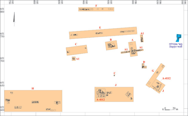
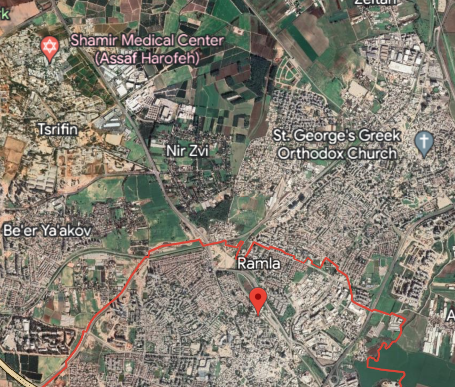
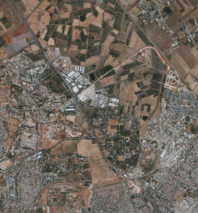
 Fig. 1
 Fig. 1
 Fig. 1


