Lod/Ramla
 A rare 1698 view of Ramla by Dutch artist Cornelius de Bruijin. Depicts the city as well as the nearby caravan staging
grounds. Arab horsemen and tent camps decorate the foreground. This view was most likely rendered in secret during de Bruijin’s second world tour.
The Holy Land was then under the control of the Ottoman Empire who imposed strict limitations on pilgrims and tourist from Europe. It is highly
unlikely that de Bruijin would have been allowed to make sketches of the region openly.
A rare 1698 view of Ramla by Dutch artist Cornelius de Bruijin. Depicts the city as well as the nearby caravan staging
grounds. Arab horsemen and tent camps decorate the foreground. This view was most likely rendered in secret during de Bruijin’s second world tour.
The Holy Land was then under the control of the Ottoman Empire who imposed strict limitations on pilgrims and tourist from Europe. It is highly
unlikely that de Bruijin would have been allowed to make sketches of the region openly.
Click on image to open a higher resolution magnifiable image in a new tab
Wikipedia and Geographicus Rare Antique Maps - Public Domain
- Fig. 1 - Coastal Palestine 644-800 CE
from Taxel (2013)
 Fig. 1
Location map
■ = urban/semi-urban/military settlement
• = rural settlement
Taxel (2013) - Fig. 1 - Location map
from Gorzalczany and Spivak (2008)
 Fig. 1
Location map.
Gorzalczany and Spivak (2008) - Fig. 2 - Ramla City Limits
from Taxel (2013)
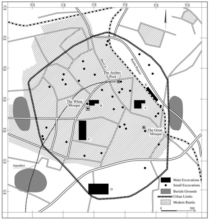 Fig. 2
Plan of Ramla city limits and excavations
courtesy of G. Avni, Israel Antiquities Authority; slightly modified
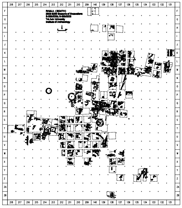
Taxel (2013) - Fig. 1.4 - Ramla (South) limits
from Tal and Taxel (2008)
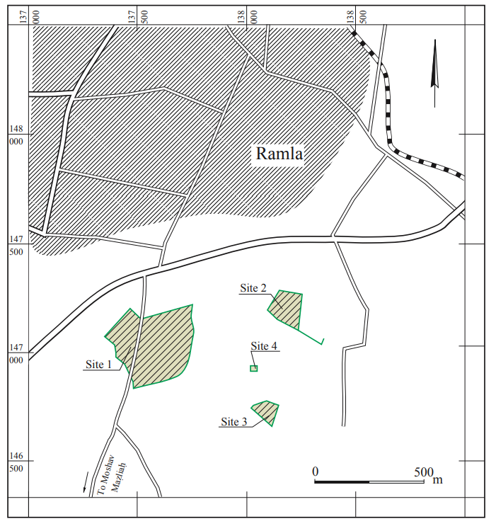 Fig. 1.4
Ramla (South) limits after Shmueli and Kanias 2007
Courtesy of the Israel Antiquities Authority
Tal and Taxel (2008)
- Annotated Google Satellite View
of Lod/Ramla from BibleWalks.com
- Fig. 6.1 - Aerial view of Ramla
showing the location of the site of Ramla (South) from Tal and Taxel (2008)
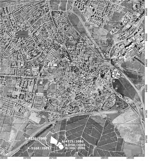 Fig. 6.1
Aerial view of Ramla showing the location of the site of Ramla (South)
Courtesy of G. Avni, Israel Antiquities Authority)
Tal and Taxel (2008) - Lod/Ramla in Google Earth
 Lod/Ramla in Google Earth
click on image to explore this site on a new tab in Google Earth - Lod/Ramla on govmap.gov.il
 Lod/Ramla on govmap.gov.il
click on image to explore this site on a new tab in govmap.gov.il - Fig. 5.3 Aerial View of White
Mosque and environs from Petersen and Pringle (2021)
 Figure 5.3
Ramla: the White Mosque and excavations south of it, seen from the air looking south
(© IAA)
Petersen and Pringle (2021) - General Area of Excavations
at Mazliah in Google Earth
 General Area of Excavations at Mazliah in Google Earth
click on image to explore this site on a new tab in Google Earth - General Area of Excavations
at Mazliah on govmap.gov.il
 General Area of Excavations at Mazliah on govmap.gov.il
click on image to explore this site on a new tab in govmap.gov.il

- Fig. 2 - Site Map from
Gorzalczany (2009b)
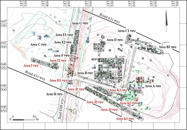 Figure 2
The excavated areas
Gorzalczany (2009b) - Master Excavation Map
from Tal and Taxel (2008)
 Master Excavation Map
Tal and Taxel (2008) - Fig. 2 - Map of excavation
areas from Gorzalczany and Spivak (2008)
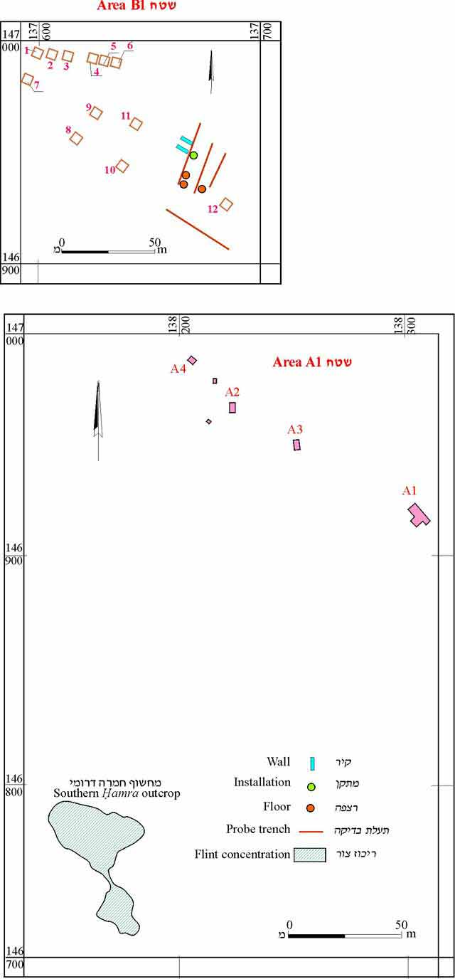 Fig. 2
Map of excavation areas.
Gorzalczany and Spivak (2008) - Fig. 2 - Plan from
Gorzalczany (2008)
 Fig. 2
הפמ תיללכ לש יחטש הריפחה חילעמב
Gorzalczany (2008) - Fig. 1 - General Plan
from Gorzalczany and Ad (2010)
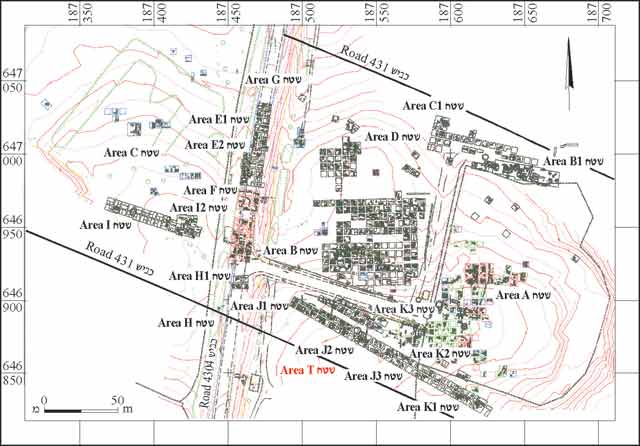 Fig. 1
General Plan.
Gorzalczany and Ad (2010) - Fig. 1.5 - Site map
with trial excavation areas from Tal and Taxel (2008)
 Fig. 1.5
Site map with indication of the trial excavation areas (A, B and C) of the Israel Antiquities Authority, on which the salvage excavation areas of the Institute of Archaeology of Tel Aviv University have been outlined (modified after Gorzalczany 2006).
Tal and Taxel (2008)
- Fig. 2 - Site Map from
Gorzalczany (2009b)
Figure 2
The excavated areas
Gorzalczany (2009b) - Master Excavation Map
from Tal and Taxel (2008)
Master Excavation Map
Tal and Taxel (2008) - Fig. 2 - Map of excavation
areas from Gorzalczany and Spivak (2008)
Fig. 2
Map of excavation areas.
Gorzalczany and Spivak (2008) - Fig. 2 - Plan from
Gorzalczany (2008)
Fig. 2
הפמ תיללכ לש יחטש הריפחה חילעמב
Gorzalczany (2008) - Fig. 1 - General Plan
from Gorzalczany and Ad (2010)
Fig. 1
General Plan.
Gorzalczany and Ad (2010) - Fig. 1.5 - Site map
with trial excavation areas from Tal and Taxel (2008)
Fig. 1.5
Site map with indication of the trial excavation areas (A, B and C) of the Israel Antiquities Authority, on which the salvage excavation areas of the Institute of Archaeology of Tel Aviv University have been outlined (modified after Gorzalczany 2006).
Tal and Taxel (2008)
- Fig. 5.4 Plan of Area B-3
and White Mosque from Petersen and Pringle (2021)
 Figure 5.4
Ramla: plan of excavated area (B3) south of the White Mosque
(© IAA)
Petersen and Pringle (2021) - Fig. 1 Plan of White Mosque
of Ramla from Rosen-Ayalon (2006)
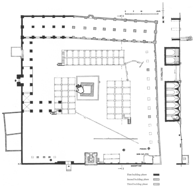 Figure 1
Plan of White Mosque of Ramla (after Kaplan 1957)
click on image to open in a new tab
Rosen-Ayalon (2006) - Fig. 2 Plan of White Mosque,
showing reconstruction of northern exedra (first building phase) from Rosen-Ayalon (2006)
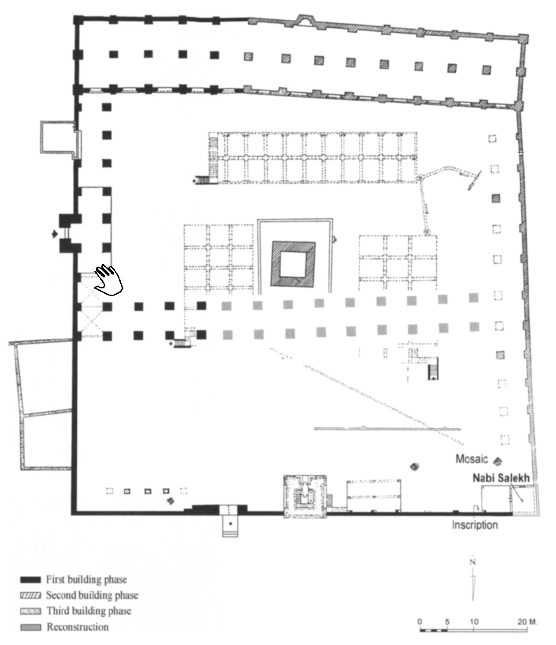 Figure 2
Plan of White Mosque, showing reconstruction of northern exedra (first building phase)
click on image to open in a new tab
Rosen-Ayalon (2006) - Fig. 3 Plan of White Mosque,
showing reconstruction of northern exedra and northern boundary wall (first building phase) from Rosen-Ayalon (2006)
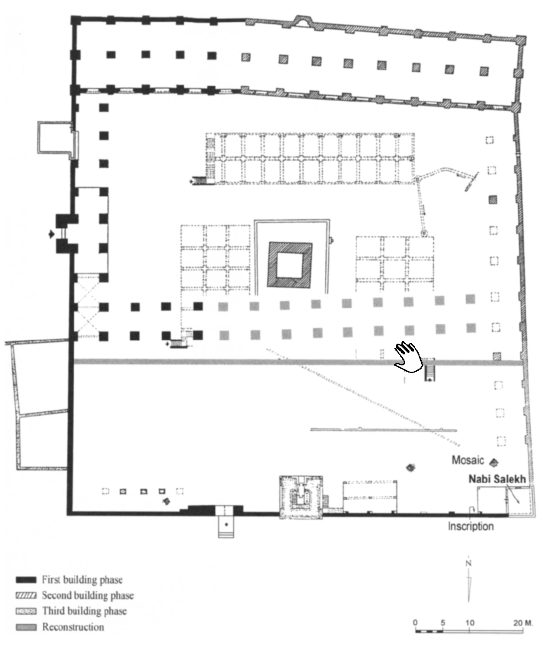 Figure 3
Plan of White Mosque, showing reconstruction of northern exedra and northern boundary wall (first building phase)
click on image to open in a new tab
Rosen-Ayalon (2006) - Fig. 6 Reconstruction of
original plan of White Mosque from Rosen-Ayalon (2006)
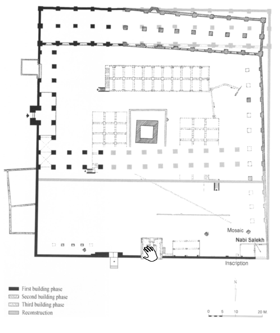 Figure 6
Reconstruction of original plan of mosque
click on image to open in a new tab
Rosen-Ayalon (2006) - Fig. 11 Abbasid cistern
superimposed over pools in White Mosque enclosure from Rosen-Ayalon (2006)
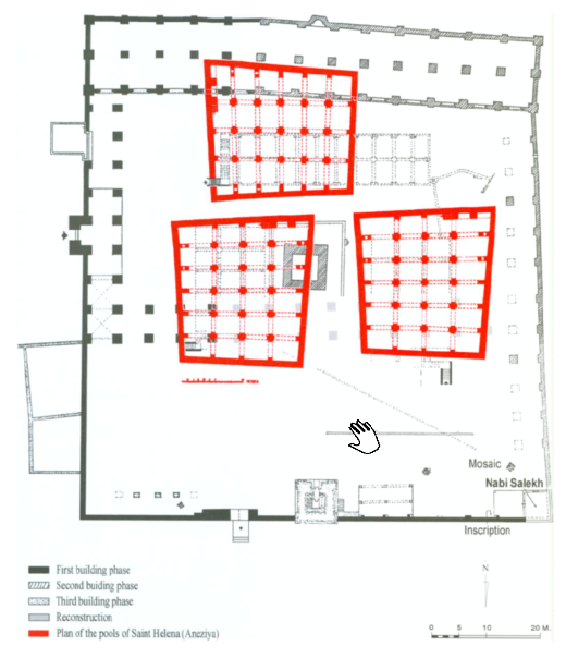 Figure 11
Abbasid cistern superimposed over pools in mosque enclosure
click on image to open in a new tab
Rosen-Ayalon (2006)
- Fig. 5.4 Plan of Area B-3
and White Mosque from Petersen and Pringle (2021)
Figure 5.4
Ramla: plan of excavated area (B3) south of the White Mosque
(© IAA)
Petersen and Pringle (2021) - Fig. 1 Plan of White Mosque
of Ramla from Rosen-Ayalon (2006)
Figure 1
Plan of White Mosque of Ramla (after Kaplan 1957)
click on image to open in a new tab
Rosen-Ayalon (2006) - Fig. 2 Plan of White Mosque,
showing reconstruction of northern exedra (first building phase) from Rosen-Ayalon (2006)
Figure 2
Plan of White Mosque, showing reconstruction of northern exedra (first building phase)
click on image to open in a new tab
Rosen-Ayalon (2006) - Fig. 3 Plan of White Mosque,
showing reconstruction of northern exedra and northern boundary wall (first building phase) from Rosen-Ayalon (2006)
Figure 3
Plan of White Mosque, showing reconstruction of northern exedra and northern boundary wall (first building phase)
click on image to open in a new tab
Rosen-Ayalon (2006) - Fig. 6 Reconstruction of
original plan of White Mosque from Rosen-Ayalon (2006)
Figure 6
Reconstruction of original plan of mosque
click on image to open in a new tab
Rosen-Ayalon (2006) - Fig. 11 Abbasid cistern
superimposed over pools in White Mosque enclosure from Rosen-Ayalon (2006)
Figure 11
Abbasid cistern superimposed over pools in mosque enclosure
click on image to open in a new tab
Rosen-Ayalon (2006)
- Plan 1 - eastern squares
of Area A from Kletter (2005)
 Plan 1
Area A, eastern squares
Kletter (2005)
- Plan 1 - eastern squares
of Area A from Kletter (2005)
Plan 1
Area A, eastern squares
Kletter (2005)
- Fig. 1.6a - General site
of the 2007 season (Squares P-T/10-12) from Tal and Taxel (2008)
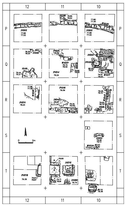 Fig. 1.6a
General site plan of the 2007 season (Squares P-T/10-12).
Tal and Taxel (2008)
- Fig. 1.6a - General site
of the 2007 season (Squares P-T/10-12) from Tal and Taxel (2008)
Fig. 1.6a
General site plan of the 2007 season (Squares P-T/10-12).
Tal and Taxel (2008)
- Fig. 1.6b - General site
plan of the 2007 season (Squares U-Y/10-12) from Tal and Taxel (2008)
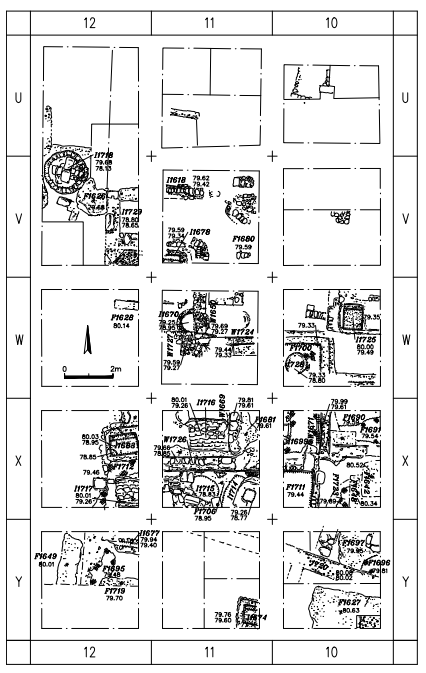 Fig. 1.6b
General site plan of the 2007 season (Squares U-Y/10-12).
Tal and Taxel (2008)
- Fig. 1.6b - General site
plan of the 2007 season (Squares U-Y/10-12) from Tal and Taxel (2008)
Fig. 1.6b
General site plan of the 2007 season (Squares U-Y/10-12).
Tal and Taxel (2008)
- Fig. 2.1 - Plan of the
Middle Bronze Age loci from Tal and Taxel (2008)
 Fig. 2.1
Plan of the Middle Bronze Age loci.
Tal and Taxel (2008)
- Fig. 2.1 - Plan of the
Middle Bronze Age loci from Tal and Taxel (2008)
Fig. 2.1
Plan of the Middle Bronze Age loci.
Tal and Taxel (2008)
- Fig. 4.1a - Plan of the
podium from Tal and Taxel (2008)
 Fig. 4.1a
Plan of the podium.
Tal and Taxel (2008)
- Fig. 4.1a - Plan of the
podium from Tal and Taxel (2008)
Fig. 4.1a
Plan of the podium.
Tal and Taxel (2008)
- Fig. 4.3a - Plan of the
plastered pool from Tal and Taxel (2008)
 Fig. 4.3a
Plan of the plastered pool.
Tal and Taxel (2008)
- Fig. 4.3a - Plan of the
plastered pool from Tal and Taxel (2008)
Fig. 4.3a
Plan of the plastered pool.
Tal and Taxel (2008)
- Fig. 5.1 - Plan of the
domestic complex from Tal and Taxel (2008)
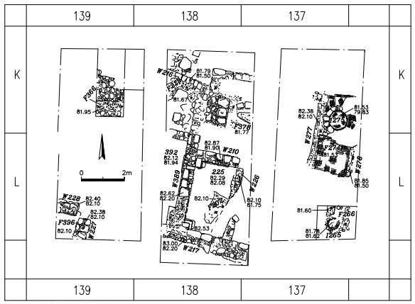 Fig. 5.1
Plan of the domestic complex.
Tal and Taxel (2008)
- Fig. 5.1 - Plan of the
domestic complex from Tal and Taxel (2008)
Fig. 5.1
Plan of the domestic complex.
Tal and Taxel (2008)
- Fig. 5.9 - Plan of the
oil press from Tal and Taxel (2008)
 Fig. 5.9
Plan of the oil press.
Tal and Taxel (2008)
- Fig. 5.9 - Plan of the
oil press from Tal and Taxel (2008)
Fig. 5.9
Plan of the oil press.
Tal and Taxel (2008)
- Fig. 5.17 - Plan of the
Northern wine press from Tal and Taxel (2008)
 Fig. 5.17
Plan of the Northern wine press.
Tal and Taxel (2008) - Fig. 5.18 - Plan of the
western wine press from Tal and Taxel (2008)
 Fig. 5.18
Western wine press. Plan of the rectangular treading floor
Tal and Taxel (2008)
- Fig. 5.17 - Plan of the
Northern wine press from Tal and Taxel (2008)
Fig. 5.17
Plan of the Northern wine press.
Tal and Taxel (2008) - Fig. 5.18 - Plan of the
western wine press from Tal and Taxel (2008)
Fig. 5.18
Western wine press. Plan of the rectangular treading floor
Tal and Taxel (2008)
- Fig. 5.24 - Plan of the
pottery kilns from Tal and Taxel (2008)
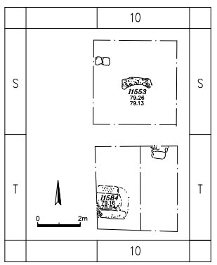 Fig. 5.24
Plan of the pottery kilns.
Tal and Taxel (2008)
- Fig. 5.24 - Plan of the
pottery kilns from Tal and Taxel (2008)
Fig. 5.24
Plan of the pottery kilns.
Tal and Taxel (2008)
- Fig. 6.2 - Schematic site
plan of the Early Islamic remains discovered during the excavations from Tal and Taxel (2008)
 Fig. 6.2
Schematic site plan of the Early Islamic remains discovered during the excavations
Tal and Taxel (2008)
- Fig. 6.2 - Schematic site
plan of the Early Islamic remains discovered during the excavations from Tal and Taxel (2008)
Fig. 6.2
Schematic site plan of the Early Islamic remains discovered during the excavations
Tal and Taxel (2008)
- Fig. 6.3a - Plan of Cistern
1590 from Tal and Taxel (2008)
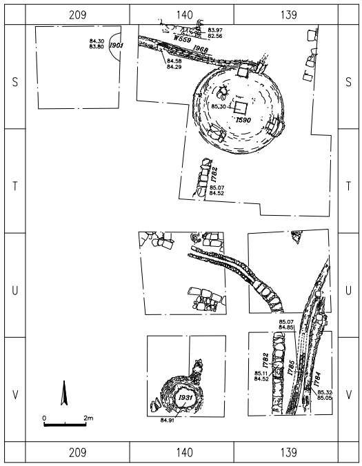 Fig. 6.3a
Plan of Cistern 1590.
Tal and Taxel (2008) - Fig. 6.5a - Plan of Cistern
1356 from Tal and Taxel (2008)
 Fig. 6.5a
Plan of Cistern 1356.
Tal and Taxel (2008) - Fig. 6.8a - Plan of Cisterns
1572 and 1964 from Tal and Taxel (2008)
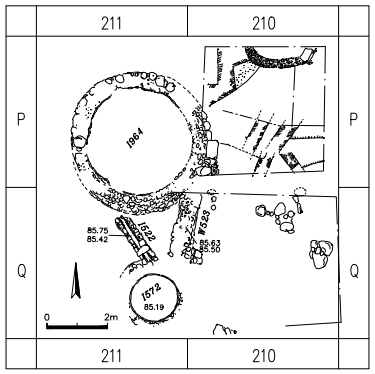 Fig. 6.8a
Plan of Cisterns 1572 and 1964
Tal and Taxel (2008)
- Fig. 6.3a - Plan of Cistern
1590 from Tal and Taxel (2008)
Fig. 6.3a
Plan of Cistern 1590.
Tal and Taxel (2008) - Fig. 6.5a - Plan of Cistern
1356 from Tal and Taxel (2008)
Fig. 6.5a
Plan of Cistern 1356.
Tal and Taxel (2008) - Fig. 6.8a - Plan of Cisterns
1572 and 1964 from Tal and Taxel (2008)
Fig. 6.8a
Plan of Cisterns 1572 and 1964
Tal and Taxel (2008)
- Fig. 6.15b - Plan of the
western pipe system from Tal and Taxel (2008)
 Fig. 6.15b
Plan of the western pipe system.
Tal and Taxel (2008)
- Fig. 6.15b - Plan of the
western pipe system from Tal and Taxel (2008)
Fig. 6.15b
Plan of the western pipe system.
Tal and Taxel (2008)
- Fig. 6.32a - Plan of Pools
1655 a-d from Tal and Taxel (2008)
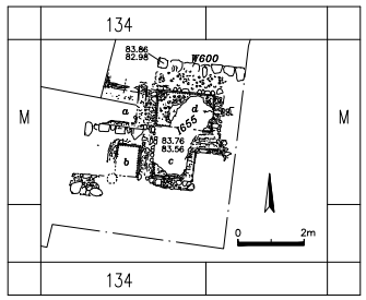 Fig. 6.32a
Plan of Pools 1655 a-d.
Tal and Taxel (2008) - Fig. 6.33a - Plan of Pools
11575 a-d from Tal and Taxel (2008)
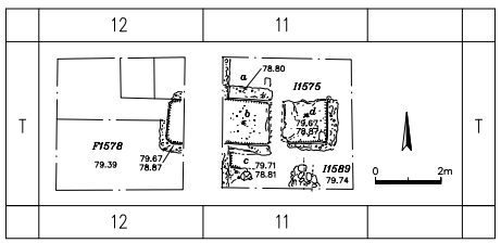 Fig. 6.33a
Plan of Pools 11575 a-d.
Tal and Taxel (2008)
- Fig. 6.32a - Plan of Pools
1655 a-d from Tal and Taxel (2008)
Fig. 6.32a
Plan of Pools 1655 a-d.
Tal and Taxel (2008) - Fig. 6.33a - Plan of Pools
11575 a-d from Tal and Taxel (2008)
Fig. 6.33a
Plan of Pools 11575 a-d.
Tal and Taxel (2008)
- Drawing of Ramla from 1487
by Conrad Grünenberg from wikipedia and Digital Badische Landes-Bibliothek
 Ramla, 1487, by Conrad Grünenberg - Double page, from Conrad Grünenberg: description of the journey from Konstanz to Jerusalem.
Lake Constance area, around 1487. Baden State Library Karlsruhe, Cod. St. Peter, pap. 32.
Ramla, 1487, by Conrad Grünenberg - Double page, from Conrad Grünenberg: description of the journey from Konstanz to Jerusalem.
Lake Constance area, around 1487. Baden State Library Karlsruhe, Cod. St. Peter, pap. 32.
Click on image to open a higher resolution magnifiable image in a new tab
Wikipedia and Digital Badische Landes-Bibliothek - Public Domain - Painting of Ramla from 1698
by Cornelis de Bruijn from wikipedia and Geographicus Rare Antique Maps
 A rare 1698 view of Ramla by Dutch artist Cornelius de Bruijin. Depicts the city as well as the nearby caravan staging
grounds. Arab horsemen and tent camps decorate the foreground. This view was most likely rendered in secret during de Bruijin’s second world tour.
The Holy Land was then under the control of the Ottoman Empire who imposed strict limitations on pilgrims and tourist from Europe. It is highly
unlikely that de Bruijin would have been allowed to make sketches of the region openly.
A rare 1698 view of Ramla by Dutch artist Cornelius de Bruijin. Depicts the city as well as the nearby caravan staging
grounds. Arab horsemen and tent camps decorate the foreground. This view was most likely rendered in secret during de Bruijin’s second world tour.
The Holy Land was then under the control of the Ottoman Empire who imposed strict limitations on pilgrims and tourist from Europe. It is highly
unlikely that de Bruijin would have been allowed to make sketches of the region openly.
Click on image to open a higher resolution magnifiable image in a new tab
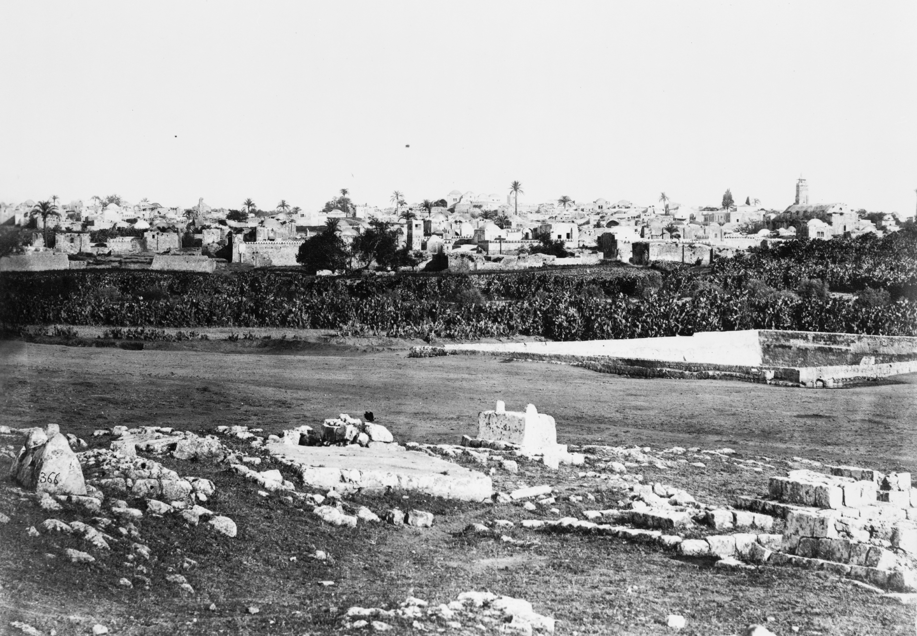
Wikipedia and Geographicus Rare Antique Maps - Public Domain - Photo of Ramla from before
1885 by Félix Bonfils from wikipedia
 Ramleh, Palestine, late 19th century. In album: Constantinople, Smyrna, Beyrout, Ba'albec, Damascus, p. 43B, pl. 86.
Click on image to open a higher resolution magnifiable image in a new tab
Wikipedia and Geographicus Rare Antique Maps - Public Domain - Photo of Ramla from 1895
from wikipedia and the Detroit Publishing Co. Collection at the U.S. Library of Congress
 View from Tower of the Forty Martyrs, Ramleh, Holy Land, ca. 1895
Click on image to open a higher resolution magnifiable image in a new tab
Wikipedia and U.S. Library of Congress - Public Domain


- Fig. 6 - Smashed Jars
from Gorzalczany and Salamon (2018)
 Fig. 6
Warehouse in Area J1-3, with dozens of smashed jars attributed to Stratum IIIb
Gorzalczany and Salamon (2018) - Fig. 9 - Smashed Jars
from Gorzalczany (2009b)
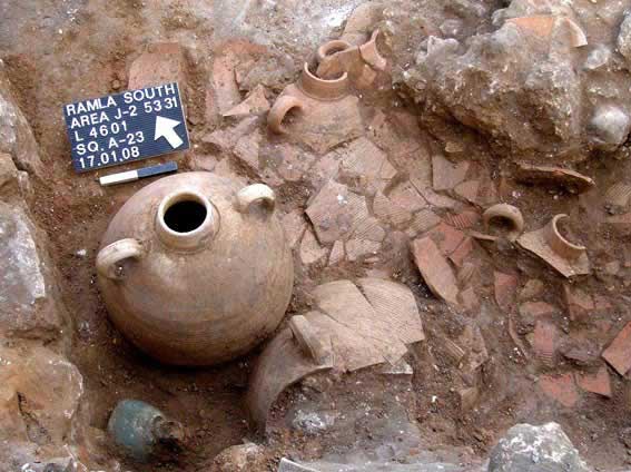 Figure 9
Shattered jars from Stratum IIIb and intact jar from Stratum IIIa; metal object in left foreground.
Gorzalczany (2009b) - Fig. 10 - Faulted strata
from Gorzalczany (2009b)
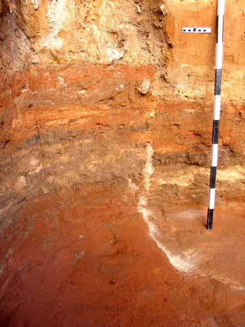 Figure 10
The fault in the sand and hamra strata caused by strong earthquake.
Gorzalczany (2009b) - Fig. 3 - Faulted Strata
from Gorzalczany and Salamon (2018)
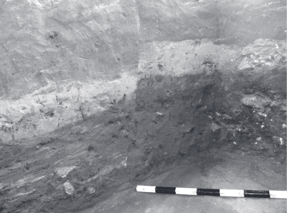 Fig. 3
Vertical section displaying superimposed layers of sand and hamra,abruptly broken by a vertical rupture
Gorzalczany and Salamon (2018) - Fig. 4 - Sunken Floor
and Column base from Gorzalczany and Salamon (2018)
 Fig. 4
Occupational layer with architectural items atop it that sank some 150 cm.
Gorzalczany and Salamon (2018) - Fig. 5 - Sunken Strata
at the antilia type water well from Gorzalczany and Salamon (2018)
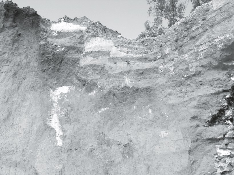 Fig. 5
Antilia well, including the pit and remains of the lifting superstructure (on the right side) that sank several meters as a whole, thus creating a configuration of layers of stepped sand and hamra. The sudden soil failure was most probably caused by the phenomenon known as liquefaction
Gorzalczany and Salamon (2018) - Fig. 2 - Collapsed Wall
with aligned courses from Gorzalczany and Salamon (2018)
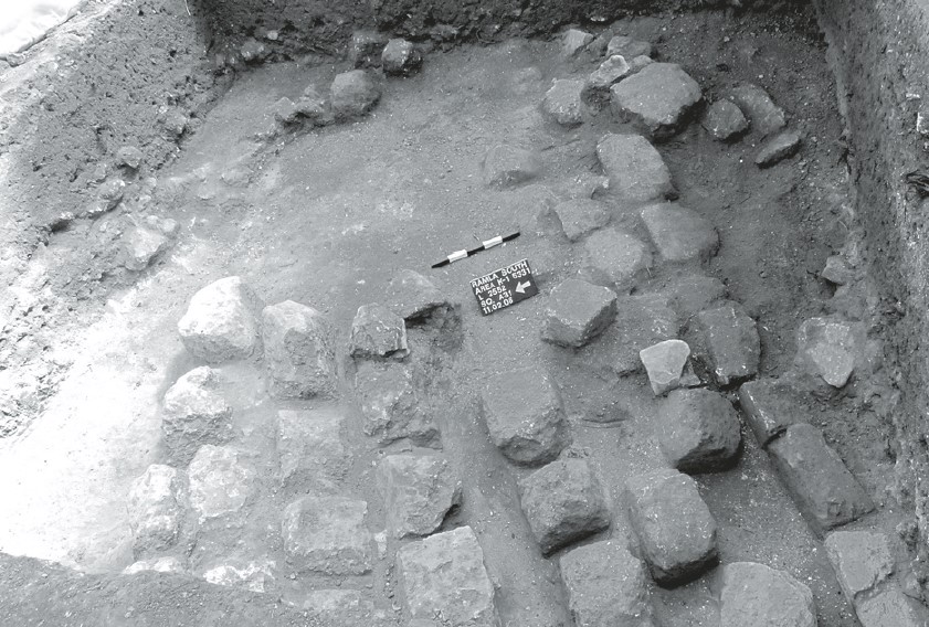 Fig. 2
Dressed stones uncovered in Area K1, which collapsed keeping the alignment in which they were originally arranged in the wall
Gorzalczany and Salamon (2018) - Fig. 6 - Tilted Wall from
Kletter (2005)
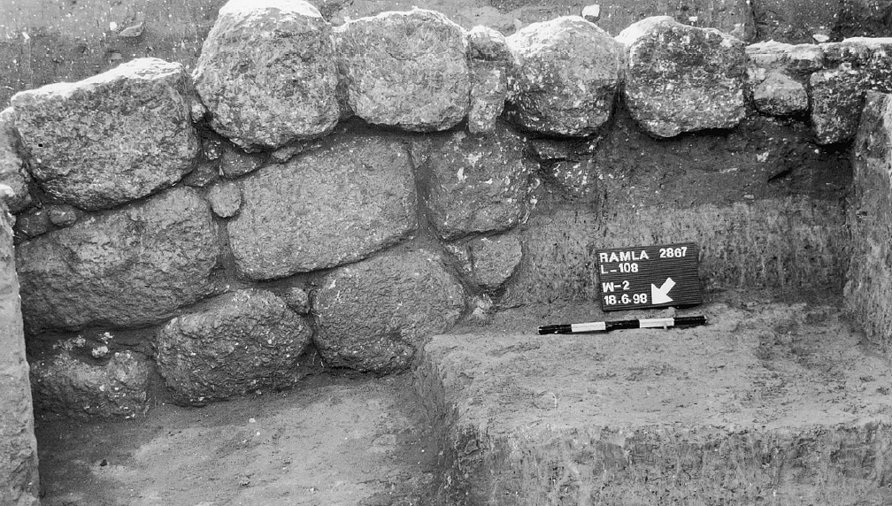 Fig. 6
Square E1, detail of W2, looking east.
JW: Two phases are evident in this photo. The lower courses are from Phase II, the earliest phase. The single top row of crude stones are from Phase I, the later phase.
Kletter (2005)
- Fig. 2 - Site Map from
Gorzalczany (2009b)
Figure 2
The excavated areas
Gorzalczany (2009b) - Fig. 6 - Smashed Jars
from Gorzalczany and Salamon (2018)
Fig. 6
Warehouse in Area J1-3, with dozens of smashed jars attributed to Stratum IIIb
Gorzalczany and Salamon (2018) - Fig. 9 - Smashed Jars
from Gorzalczany (2009b)
Figure 9
Shattered jars from Stratum IIIb and intact jar from Stratum IIIa; metal object in left foreground.
Gorzalczany (2009b) - Fig. 10 - Faulted strata
from Gorzalczany (2009b)
Figure 10
The fault in the sand and hamra strata caused by strong earthquake.
Gorzalczany (2009b) - Fig. 3 - Faulted Strata
from Gorzalczany and Salamon (2018)
Fig. 3
Vertical section displaying superimposed layers of sand and hamra,abruptly broken by a vertical rupture
Gorzalczany and Salamon (2018) - Fig. 4 - Sunken Floor
and Column base from Gorzalczany and Salamon (2018)
Fig. 4
Occupational layer with architectural items atop it that sank some 150 cm.
Gorzalczany and Salamon (2018) - Fig. 5 - Sunken Strata
at the antilia type water well from Gorzalczany and Salamon (2018)
Fig. 5
Antilia well, including the pit and remains of the lifting superstructure (on the right side) that sank several meters as a whole, thus creating a configuration of layers of stepped sand and hamra. The sudden soil failure was most probably caused by the phenomenon known as liquefaction
Gorzalczany and Salamon (2018) - Fig. 2 - Collapsed Wall
with aligned courses from Gorzalczany and Salamon (2018)
Fig. 2
Dressed stones uncovered in Area K1, which collapsed keeping the alignment in which they were originally arranged in the wall
Gorzalczany and Salamon (2018)
Gorzalczany (2009b) described 8th century CE earthquake evidence as follows:
Evidence of a major earthquake was discerned in Areas J2 and K1 (see Fig. 2 - site map); it included cracks along the walls of installations, large sections of collapse composed of neat ashlar stone construction that had not been robbed, floors that had dropped and walls that curved in unexpected directions. Wall collapse, which had been intentionally covered over with soil and hamra to save the building stones from being plundered, was observed. It seems that the residents of the town were concerned with the quick restoration of the settlement’s activity. Especially interesting was a series of jars, some positioned upside down, which were discovered in situ, smashed inside a room that was apparently used for storage [Fig. 6Thus, we have earthquake evidence which is precisely dated and well described. The 1.5 meter sinking of the column base (Fig. 4]. The jars dated to the first half of the eighth century CE and they seem to have been all damaged simultaneously in the same event. The room was leveled and quickly refurbished in an attempt to regain its capacity for industrial manufacture as soon as possible. The renovation of the room included the construction of new walls, with which jars dating to the second half of the eighth century CE were associated and preserved intact (Fig. 9
Warehouse in Area J1-3, with dozens of smashed jars attributed to Stratum IIIb
Gorzalczany and Salamon (2018)). It therefore seems that we have here a small, rare chronological window, which enables us to date the earthquake.
Shattered jars from Stratum IIIb and intact jar from Stratum IIIa; metal object in left foreground.
Gorzalczany (2009b)
Indisputable proof of the earthquake occurrence was found in the balks of Area K1, where a fault in the layers of sand and hamra, which were split due to a fissure, stands out prominently (Fig. 10). One side of the layers in the section was lower than the other side. The fissure continued along several excavation squares and it caused a plaster floor and a column base that stood above it to sink 1.5 m [Fig. 4like this """Gorzalczany (2009b)
The fault in the sand and hamra strata caused by strong earthquake.
Gorzalczany (2009b)]. Such vertical movement of layers could only be caused by a powerful seismic event. An opposite fracture was discerned elsewhere on the site, where the movement was not only vertical but also horizontal, causing the layers to climb one atop the other [Fig. 5
Occupational layer with architectural items atop it that sank some 150 cm.
Gorzalczany and Salamon (2018)]. It appears then that archaeological evidence of an earthquake, which occurred close to Ramla in the middle of the eighth century CE, can be pointed to for the first time. The dating is firmly based on the pottery and it is feasible that this is the famous earthquake of the year 749 CE.
Antilia well, including the pit and remains of the lifting superstructure (on the right side) that sank several meters as a whole, thus creating a configuration of layers of stepped sand and hamra. The sudden soil failure was most probably caused by the phenomenon known as liquefaction
Gorzalczany and Salamon (2018)
Fig. 4Occupational layer with architectural items atop it that sank some 150 cm.
Gorzalczany and Salamon (2018)
the entire antilia installation - the pit and the lifting superstructure device together with the layers of fill and the occupation layer abutting them - collapsed and sank several meters. Damage to surrounding areas indicates that the pit (Fig. 5) constituted the central axis of the falland
the sand layers around the antilia [that appeared] broken in a stepped formation (Fig. 5)encompassed the pit.
Gorzalczany and Salamon (2018) added an observation of building stones of walls that had collapsed in a clear, `orderly' pattern found in situ (Fig. 2
Fig. 2Dressed stones uncovered in Area K1, which collapsed keeping the alignment in which they were originally arranged in the wall
Gorzalczany and Salamon (2018)
- Plan 1 - eastern squares
of Area A from Kletter (2005)
Plan 1
Area A, eastern squares
Kletter (2005) - Fig. 6 - Tilted Wall
from Kletter (2005)
Fig. 6
Square E1, detail of W2, looking east.
JW: Two phases are evident in this photo. The lower courses are from Phase II, the earliest phase. The single top row of crude stones are from Phase I, the later phase.
Kletter (2005)
| Effect | Location | Image(s) | Description |
|---|---|---|---|
|
Areas J2 and K1
Figure 2 The excavated areas Gorzalczany (2009b)
Fig. 2הפמ תיללכ לש יחטש הריפחה חילעמב Gorzalczany (2008) |
Fig. 2
Fig. 2 Dressed stones uncovered in Area K1, which collapsed keeping the alignment in which they were originally arranged in the wall Gorzalczany and Salamon (2018) |
|
| Broken Pottery found in fallen position | Warehouse in Area J1-3
Figure 2 The excavated areas Gorzalczany (2009b)
Fig. 2הפמ תיללכ לש יחטש הריפחה חילעמב Gorzalczany (2008) |
Fig. 6
Fig. 6 Warehouse in Area J1-3, with dozens of smashed jars attributed to Stratum IIIb Gorzalczany and Salamon (2018) Fig. 9
Figure 9Shattered jars from Stratum IIIb and intact jar from Stratum IIIa; metal object in left foreground. Gorzalczany (2009b) |
|
| Collapsed Walls | Area K1
Figure 2 The excavated areas Gorzalczany (2009b)
Fig. 2הפמ תיללכ לש יחטש הריפחה חילעמב Gorzalczany (2008) |
Fig. 2
Fig. 2 Dressed stones uncovered in Area K1, which collapsed keeping the alignment in which they were originally arranged in the wall Gorzalczany and Salamon (2018) |
|
|
Area K1
Figure 2 The excavated areas Gorzalczany (2009b)
Fig. 2הפמ תיללכ לש יחטש הריפחה חילעמב Gorzalczany (2008) |
Fig. 10
Figure 10 The fault in the sand and hamra strata caused by strong earthquake. Gorzalczany (2009b)
Fig. 3Vertical section displaying superimposed layers of sand and hamra,abruptly broken by a vertical rupture Gorzalczany and Salamon (2018) Fig. 4
Fig. 4Occupational layer with architectural items atop it that sank some 150 cm. Gorzalczany and Salamon (2018) Fig. 5
Fig. 5Antilia well, including the pit and remains of the lifting superstructure (on the right side) that sank several meters as a whole, thus creating a configuration of layers of stepped sand and hamra. The sudden soil failure was most probably caused by the phenomenon known as liquefaction Gorzalczany and Salamon (2018) |
|
| Rebuilding ? | White Mosque at Ramla
Fig. 2 Plan of Ramla city limits and excavations courtesy of G. Avni, Israel Antiquities Authority; slightly modified Taxel (2013) |
|
| Effect | Location | Image(s) | Description |
|---|---|---|---|
| Collapsed Walls | Ramla |
|
|
| Rebuilding ? | White Mosque at Ramla
Fig. 2 Plan of Ramla city limits and excavations courtesy of G. Avni, Israel Antiquities Authority; slightly modified Taxel (2013) |
|
| Effect | Location | Image(s) | Description |
|---|---|---|---|
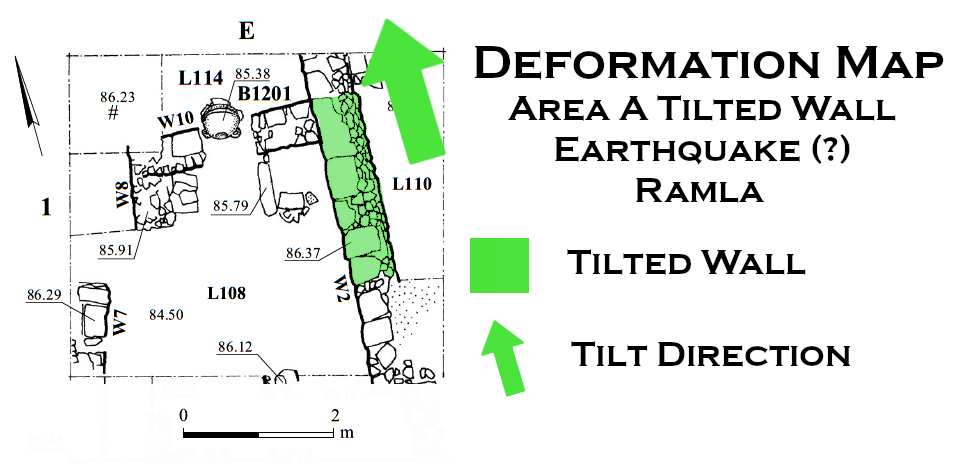
| Tilted Wall | Wall W2 in Square E1 of Area A, located “within ‘Opher Park below newly constructed ‘Opher School in Ramla.”
Plan 1 Area A, eastern squares Kletter (2005) |
Fig. 6 Square E1, detail of W2, looking east. JW: Two phases are evident in this photo. The lower courses are from Phase II, the earliest phase. The single top row of crude stones are from Phase I, the later phase. Kletter (2005) |
|
- Modified by JW from Plan 1 of Kletter (2005)
 Deformation Map
click on image to open in a new tab
Modified by JW from Plan 1 of Kletter (2005)
- Earthquake Archeological Effects chart
of Rodríguez-Pascua et al (2013: 221-224)
 Earthquake Archeological Effects (EAE)
Rodríguez-Pascua et al (2013: 221-224)
| Effect | Location | Image(s) | Description | Intensity |
|---|---|---|---|---|
|
Ramla |
|
|
- Earthquake Archeological Effects chart
of Rodríguez-Pascua et al (2013: 221-224)
Earthquake Archeological Effects (EAE)
Rodríguez-Pascua et al (2013: 221-224)
| Effect | Location | Image(s) | Description | Intensity |
|---|---|---|---|---|
|
Areas J2 and K1
Figure 2 The excavated areas Gorzalczany (2009b)
Fig. 2הפמ תיללכ לש יחטש הריפחה חילעמב Gorzalczany (2008) |
Fig. 2
Fig. 2 Dressed stones uncovered in Area K1, which collapsed keeping the alignment in which they were originally arranged in the wall Gorzalczany and Salamon (2018) |
|
|
| Broken Pottery found in fallen position | Warehouse in Area J1-3
Figure 2 The excavated areas Gorzalczany (2009b)
Fig. 2הפמ תיללכ לש יחטש הריפחה חילעמב Gorzalczany (2008) |
Fig. 6
Fig. 6 Warehouse in Area J1-3, with dozens of smashed jars attributed to Stratum IIIb Gorzalczany and Salamon (2018) Fig. 9
Figure 9Shattered jars from Stratum IIIb and intact jar from Stratum IIIa; metal object in left foreground. Gorzalczany (2009b) |
|
VII+ |
| Collapsed Walls | Area K1
Figure 2 The excavated areas Gorzalczany (2009b)
Fig. 2הפמ תיללכ לש יחטש הריפחה חילעמב Gorzalczany (2008) |
Fig. 2
Fig. 2 Dressed stones uncovered in Area K1, which collapsed keeping the alignment in which they were originally arranged in the wall Gorzalczany and Salamon (2018) |
|
VIII+ |
|
Area K1
Figure 2 The excavated areas Gorzalczany (2009b)
Fig. 2הפמ תיללכ לש יחטש הריפחה חילעמב Gorzalczany (2008) |
Fig. 10
Figure 10 The fault in the sand and hamra strata caused by strong earthquake. Gorzalczany (2009b)
Fig. 3Vertical section displaying superimposed layers of sand and hamra,abruptly broken by a vertical rupture Gorzalczany and Salamon (2018) Fig. 4
Fig. 4Occupational layer with architectural items atop it that sank some 150 cm. Gorzalczany and Salamon (2018) Fig. 5
Fig. 5Antilia well, including the pit and remains of the lifting superstructure (on the right side) that sank several meters as a whole, thus creating a configuration of layers of stepped sand and hamra. The sudden soil failure was most probably caused by the phenomenon known as liquefaction Gorzalczany and Salamon (2018) |
|
|
| Rebuilding ? | White Mosque at Ramla
Fig. 2 Plan of Ramla city limits and excavations courtesy of G. Avni, Israel Antiquities Authority; slightly modified Taxel (2013) |
|
? |
- Earthquake Archeological Effects chart
of Rodríguez-Pascua et al (2013: 221-224)
Earthquake Archeological Effects (EAE)
Rodríguez-Pascua et al (2013: 221-224)
| Effect | Location | Image(s) | Description | Intensity |
|---|---|---|---|---|
| Collapsed Walls | Ramla |
|
VIII+ | |
| Rebuilding ? | White Mosque at Ramla
Fig. 2 Plan of Ramla city limits and excavations courtesy of G. Avni, Israel Antiquities Authority; slightly modified Taxel (2013) |
|
? |
- Earthquake Archeological Effects chart
of Rodríguez-Pascua et al (2013: 221-224)
Earthquake Archeological Effects (EAE)
Rodríguez-Pascua et al (2013: 221-224)
| Effect | Location | Image(s) | Description | Intensity |
|---|---|---|---|---|
| Tilted Wall | Wall W2 in Square E1 of Area A, located “within ‘Opher Park below newly constructed ‘Opher School in Ramla.”
Plan 1 Area A, eastern squares Kletter (2005) |
Fig. 6 Square E1, detail of W2, looking east. JW: Two phases are evident in this photo. The lower courses are from Phase II, the earliest phase. The single top row of crude stones are from Phase I, the later phase. Kletter (2005) |
|
VI+ |