Shivta
 Shivta on govmap.gov.il
click on image to explore this site on a new tab in govmap.gov.il
| Transliterated Name | Source | Name |
|---|---|---|
| Shivta | Hebrew | שבטה |
| Subeita | Arabic | شبطا |
| Isbeita | Arabic | يسبييتا |
| Sobata | Ancient Greek | Σόβατα |
- Roads and cities in the
Negev during Nabataean and Roman/Byzantine periods from biblewalks.com
 Map of the ancient cities along the Incense/Spice route – during the Nabatean and Roman/Byzantine periods periods
(based on Bible Mapper 3.0)
Used with permission from biblewalks.com - Annotated Aerial View
from BibleWalks.com
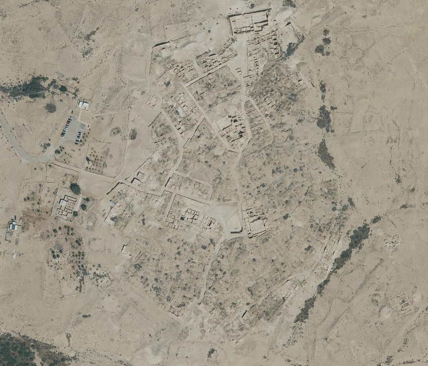
- Fig. 2 - Aerial Photo of
Shivta from Erickson-Gini (2013)
 Fig. 2
Aerial photo of Building 121 and surrounding area.
Erickson-Gini (2013) - Shivta in Google Earth
 Shivta
click on image to explore this site on a new tab in Google Earth - Shivta on govmap.gov.il
Shivta on govmap.gov.il
click on image to explore this site on a new tab in govmap.gov.il

- Fig. 1 - Site Plan from
Korjenkov and Mazor (1999a)
 Fig. 1. (b)
A map of Shivta following Segal (1983)
Korjenkov and Mazor (1999a) - Site Plan from BibleWalks.com
- Site Plan with
building numbers from Hirschfeld (2003)
 Site plan of Shivta with building numbers
Click on image to open a high res magnifiable version in a new tab
Hirschfeld (2003) - Fig. 2 - Aerial photograph
from Segal (1985)
 Fig. 2
Shivta, aerial photograph, scale 1:1,000
Segal (1985)


- Fig. 1 - Site Plan from
Korjenkov and Mazor (1999a)
Fig. 1. (b)
A map of Shivta following Segal (1983)
Korjenkov and Mazor (1999a) - Site Plan with
building numbers from Hirschfeld (2003)
Site plan of Shivta with building numbers
Click on image to open a high res magnifiable version in a new tab
Hirschfeld (2003) - Fig. 2 - Aerial photograph
from Segal (1985)
Fig. 2
Shivta, aerial photograph, scale 1:1,000
Segal (1985)
- Plan of the Northern
Church from Stern et al (1993 v. 4)
 Plan of the North Church
Stern et al (1993 v. 4) - Fig. 1 - Plan of the Northern
Church from Margalit (1987)
 Fig. 1
North Church of Shivta: plan of the church made by Colt Expedition
(Republished by R. Rosenthal-Hegenbottom)
Margalit (1987) - Isometric reconstruction
of the Northern Church from Stern et al (1993 v. 4)
 Isometric reconstruction of the North Church.
Stern et al (1993 v. 4) - Fig. 4 - Isometric
cutaway of the mono-apsidal Northern Church from Negev (1989)
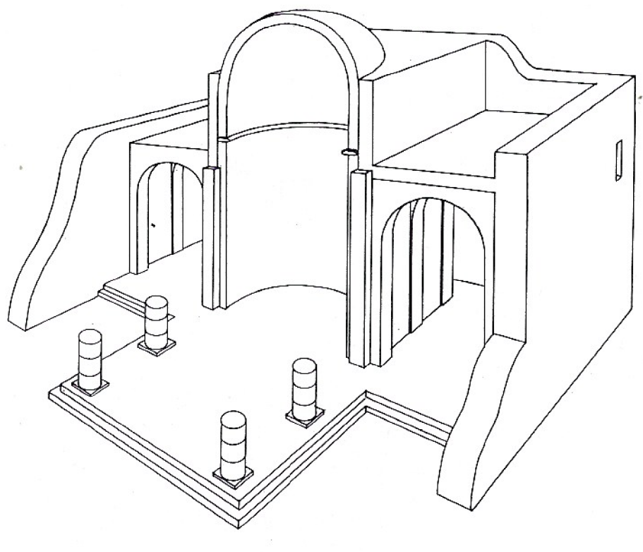 Fig. 4
Sobata North Church
Negev (1989) - Fig. 8 - Isometric
cutaway of the tri-apsidal Northern Church from Negev (1989)
 Fig. 8
Sobata North Church
Negev (1989)
- Plan of the Northern
Church from Stern et al (1993 v. 4)
Plan of the North Church
Stern et al (1993 v. 4) - Fig. 1 - Plan of the Northern
Church from Margalit (1987)
Fig. 1
North Church of Shivta: plan of the church made by Colt Expedition
(Republished by R. Rosenthal-Hegenbottom)
Margalit (1987)
- Fig. 5 - Isometric
cutaway of the mono-apsidal South Church from Negev (1989)
 Fig. 5
Sobata South Church
Negev (1989) - Fig. 9 - Isometric
cutaway of the tri-apsidal South Church from Negev (1989)
 Fig. 9
Sobata South Church
Negev (1989)
- Fig. 11 - Plan of
the tri-apsidal Central Church from Negev (1989)
 Fig. 11
Sobata Central Church
Negev (1989)
- Fig. 3 - Plan of Building 121
from Erickson-Gini (2013)
 Fig. 3
Building 121, plan and section of the 2009 excavation.
Erickson-Gini (2013)
- Fig. 3 - Plan of Building 121
from Erickson-Gini (2013)
Fig. 3
Building 121, plan and section of the 2009 excavation.
Erickson-Gini (2013)
- Broken and repaired lintel
stone (top of photo) at entrance to South Church (photo by JW)
 Broken and repaired lintel stone (top of photo) at entrance to South Church in Shivta
photo by Jefferson Williams
- Fig. 4 - Isometric cutaway
of the tri-apsidal Northern Church from Negev (1989)
Fig. 4
Sobata North Church
Negev (1989) - Fig. 5 - Isometric cutaway
of the mono-apsidal South Church from Negev (1989)
Fig. 5
Sobata South Church
Negev (1989)
- Deformation Map showing
location of revetment wall of bldg. 123 highlighted pink - modified from Hirschfeld (2003)
- Fig. 1 - Site Plan from
Korjenkov and Mazor (1999a)
Fig. 1. (b)
A map of Shivta following Segal (1983)
Korjenkov and Mazor (1999a) - Fig. 2 - Aerial Photo of
Bldg. 121 and surroundings Erickson-Gini (2013)
Fig. 2
Aerial photo of Building 121 and surrounding area.
Erickson-Gini (2013) - Fig. 2 - Closeup Aerial
Photo of Bldg. 121 and surroundings Erickson-Gini (2013)
 Fig. 2
Aerial photo of Building 121 and surrounding area.
Erickson-Gini (2013) - Site Plan with bldg 121
and revetment wall of bldg. 123 highlighted yellow from Hirschfeld (2003)
 Site plan of Shivta with bldg 121 and revetment wall of bldg. 123 highlighted yellow
Click on image to open a high res magnifiable version in a new tab
Hirschfeld (2003) - Site Plan with bldg 121
and revetment wall of bldg. 123 highlighted yellow from Hirschfeld (2003) (magnified)
Site plan of Shivta with bldg 121 and revetment wall of bldg. 123 highlighted yellow
Click on image to open a high res magnifiable version in a new tab
Hirschfeld (2003) - Fig. 3 - Plan of Building 121
from Erickson-Gini (2013)
Fig. 3
Building 121, plan and section of the 2009 excavation.
Erickson-Gini (2013) - Fig. 5 - Collapse of W1
in the courtyard of Building 121 from Erickson-Gini (2013)
 Fig. 5
Collapse of W1 in the courtyard, looking southwest
Erickson-Gini (2013) - Fig. 7 - Collapsed Arches
and ceiling slabs along W2 in Room 2 of Building 121 from Erickson-Gini (2013)
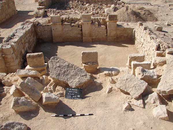 Fig. 7
Room 2, collapsed arches and ceiling slabs along W2, looking west.
Erickson-Gini (2013) - Fig. 8 - Earthquake Collapse
in Room 2 of Building 121 from Erickson-Gini (2013)
 Fig. 8
Room 2, section showing earthquake collapse, looking east
Erickson-Gini (2013)

| Effect | Location | Figure | Comments |
|---|---|---|---|
| Revetment Wall suggesting wall damage | Northern and southern churches
Fig. 1. (b) A map of Shivta following Segal (1983) Korjenkov and Mazor (1999a) |
|
| Effect | Location | Figure | Comments |
|---|---|---|---|
| Revetment Wall suggesting wall damage | location not specified | 15  Fig. 15
A supporting wall (marked S.W.). It has no obvious purpose other than to support a tilted section of an original wall of a building at the west—central quarter, Shivta. Such support walls are known from other locations at Shivta as well as at Avdat, Rehovot, and Mamshit. At these locations the tilting of the original walls was caused by earthquakes (Korjenkov and Mazor, 1999b). Korjenkov and Mazor (1999a) |
Figure 15 depicts an example of a well built inclined wall that supports a tilted section of a wall of a house at the west—central quarter. Similar support walls are observable at Avdat where these walls reveal a systematic trend, indicating the supported walls were tilted by an earthquake (Korjenkov and Mazor, 1999a). Similarly, the supporting walls of Shivta seem to reflect a former earthquake, in agreement with the above-listed observations that indicate earthquake damage. In certain cases, such support walls are themselves seismically damaged, indicating a second earthquake event.- Korjenkov and Mazor (1999a) |
| Revetment Wall suggesting wall damage | Western wall of Building 123 |
|

| Effect | Location | Figure | Comments |
|---|---|---|---|
| Wall and Ceiling collapse | Room 2 in Building 121
Fig. 3 Building 121, plan and section of the 2009 excavation. Erickson-Gini (2013) |
Fig. 8 Room 2, section showing earthquake collapse, looking east Erickson-Gini (2013) |
collapse of the ceilings and parts of the walls- Erickson-Gini (2013) |
| Collapsed Wall | Wall 1 in Courtyard of Building 121
Fig. 3 Building 121, plan and section of the 2009 excavation. Erickson-Gini (2013) |
Fig. 5 Collapse of W1 in the courtyard, looking southwest Erickson-Gini (2013) |
Collapse of W1 in the courtyard- Erickson-Gini (2013) |
| Arch Collapse | Room 2 along W2 of Building 121
Fig. 3 Building 121, plan and section of the 2009 excavation. Erickson-Gini (2013) |
Fig. 7 Room 2, collapsed arches and ceiling slabs along W2, looking west. Erickson-Gini (2013) |
collapsed arches and ceiling slabs- Erickson-Gini (2013) |
| Damage Type | Location | Figure | Comments |
|---|---|---|---|
| Asymmetric arch distortion | SE Corner of Southern Church
 Fig. 1. (c)
City Plan of Shivta following Segal (1983) dots mark field stations of the present study, circles with numbers denote figure locations. Korjenkov and Mazor (1999a) |
3  Fig. 3
(a) Asymmetric deformation of an arch trending ENE in a room at the SE corner of the Southern Church (b) A photograph of two parallel arches deformation of the near one is portrayed in Fig. 3a. The two arches were deformed to opposite directions, indicating that these arches responded to different phases of the seismic waves. Korjenkov and Mazor (1999a) |
Seismic wave propagation was parallel to the arch trend In such cases the direction of the seismic wave propagation was parallel to the arch direction. In the example given in Fig. 3 the arch trend was 61° and, hence, the seismic wave propagation was ENE-WSW. |
| Partially collapsed arch stones | One of the courtyards of the northern quarter
Fig. 1. (c) City Plan of Shivta following Segal (1983) dots mark field stations of the present study, circles with numbers denote figure locations. Korjenkov and Mazor (1999a) |
4  Fig. 4
Partial collapse of arch stones at Shivta in one of the courtyards of the northern quarter: (a) oblique view of the findings in the field (b,c) stones 1-3 and 17-18 belong to the arch supports and are still standing, whereas arch stones 14-16 are still hanging, and stones 4-13 lie on the ground. Korjenkov and Mazor (1999a) |
Seismic waves arrived parallel to the direction of the arch In this example the arch support stones are still standing though slightly displaced, a few stones of the arch are still in the air, and the rest of the stones lie on the ground. The direction of the seismic wave propagation was parallel, or nearly parallel, to the original arch trend. The arch trend was 238°, hence the direction of the seismic waves propagation was along an axis of about NE—SW. |
| Non-shifted collapse of arches | various locations | 5  Fig. 5
Collapse patterns of arch stones: (a) arch stones lie on the ground in a straight line - seismic waves came parallel to the arch trend (b) arch stones lie on the ground in a crescent pattern - seismic waves came perpendicular to the original arch trend. Korjenkov and Mazor (1999a) |
Seismic waves arrived parallel to the arch direction Arch stones that lie on the ground in a straight line below the original arch position (Fig. 4a) indicate that the seismic waves propagated in a direction that was parallel to the original arch trend. Eight cases have been observed at Shivta, indicating the seismic wave propagation along a SW—NE axis. |
| Crescent collapse patterns of arches | various locations | 5
Fig. 5 Collapse patterns of arch stones: (a) arch stones lie on the ground in a straight line - seismic waves came parallel to the arch trend (b) arch stones lie on the ground in a crescent pattern - seismic waves came perpendicular to the original arch trend. Korjenkov and Mazor (1999a) |
Seismic waves arrived perpendicular to the arch direction Arch stones that lie on the ground in a crescent pattern (Fig. 5b) indicate that the seismic waves arrived in a direction perpendicular to the original arch trend. Five such cases have been found at Shivta, indicating the seismic waves arrived in a SW-NE direction. |
| Systematic rotation of wall fragments around the vertical axis | various locations | 6c  Fig. 6
(c) angles of rotation measured at Shivta as a function of the trend of the respective walls. Walls with a trend of 40°-50° reveal clockwise rotations, whereas the perpendicular walls with a trend of 120°-125° reveal a counterclockwise rotation. These observations indicate that the seismic waves arrived along the bisector of these trends, i.e., from the WSW. Korjenkov and Mazor (1999a) |
Indicating azimuth of epicenter and seismic intensity Five clockwise rotations were observed at Shivta on walls trending 40°-50° and, in contrast, 4 cases of counterclockwise rotations were observed on the perpendicular walls, trending 120°-130° (Fig. 6c). Thus, the seismic waves came along the bisector of these wall trends, i.e., the seismic waves arrived from the WSW. Rotation of single stones, wall fragments, or entire walls around a vertical axis indicate arrival of the seismic waves at some angle to the wall trend. The theoretical background of this phenomenon has been discussed in detail by Korjenkov and Mazor (1999a,b). Similar rotational damage patterns were observed at the Suusamyr earthquake (I = 9-10, MSK-64 scale) as described by Korjenkov and Omuraliev (1993) and Omuraliev et al. (1993b). By analogy, it seems that the intensity of the seismic event that destroyed Shivta was at least I= 8-9 (MSK-64 scale). |
| Stones rotated around a horizontal axis in collapsed arches | Courtyard of the west-central quarter
Fig. 1. (c) City Plan of Shivta following Segal (1983) dots mark field stations of the present study, circles with numbers denote figure locations. Korjenkov and Mazor (1999a) |
7a 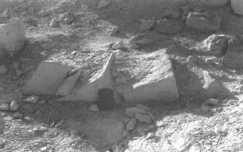 Fig. 7
(a) Systematic rotation of fallen arch stones in a courtyard of the west-central quarter, Shivta, implying an inclined direction of the arriving seismic waves, which in turn indicates that the hypocenter was relatively close Korjenkov and Mazor (1999a) |
The direction of the seismic waves was inclined, indicating a nearby hypocenter Two examples of arch stones lying on the ground, each stone being rotated around a horizontal axis, have been observed at Shivta. One example is shown in Fig. 7a, leading to the following conclusions:
|
| Sagged roof slabs rotated around a horizontal axis | Building at the north quarter of Shivta
Fig. 1. (c) City Plan of Shivta following Segal (1983) dots mark field stations of the present study, circles with numbers denote figure locations. Korjenkov and Mazor (1999a) |
7b  Fig. 7
(b) Sagged and rotated roof slabs in a building at the north quarter of Shivta: rotations of this nature indicate that the seismic waves arrived at some angle to the slabs, excluding the possibility that the hypo-center was beneath Shivta, and limiting the possible distance of the epicenter to not more than a few tens of kilometers. Korjenkov and Mazor (1999a) |
The direction of the seismic waves was inclined, indicating a nearby hypocenter Figure 7b depicts a row of sagged roof slabs that were also rotated, at a building at the north quarter of Shivta. The tilting of the individual slabs indicates a rotational movement. By the same arguments discussed in the previous section, this indicates that the direction of the arriving seismic waves was inclined, which further indicates that the hypocenter was relatively close to the study location, a few tens of kilometers away. The trend of the row of roof slabs is 138°, hence the direction of the arriving seismic waves was along the SW—NE axis. |
| Systematic collapse of walls and agricultural fences | various locations | 8a  Fig. 8
(a) Preferential collapse of a city wall in the northern quarter of Shivta (trending SE 141°); the arrival of the seismic waves was in a perpendicular direction, i.e., along a SW—NE axis Korjenkov and Mazor (1999a) 8b  Fig. 8
(b) Preferential collapse of an agricultural fence north of Shivta (trending SE); the arrival of the seismic wave was in a perpendicular direction, i.e., along a SW—NE axis. In both cases the collapsed stones were thrown relatively far away, up to around 8 meters; an earthquake intensity of about I = 8 is concluded Korjenkov and Mazor (1999a) 8c  Fig. 8
(c) Direction of clear collapse cases observed at the Byzantine walls at Shivta, as a function of wall directions: it can be seen that 15 cases of collapse toward SW have been observed on walls trending 100°-160°, whereas only 4 cases of collapse toward NE are observable in walls of the same trend. This clearly preferred orientation of collapse indicates destruction by an earthquake, and the seismic waves arrived along a NE—SW axis. Korjenkov and Mazor (1999a) |
Indicating seismic intensity and "general direction" of seismic wave propagation Figure 8a shows a wall of a building, trending SE 141°, that collapsed in a SW 231° direction. Figure 8b depicts an agricultural wall trending SE, revealing a distinct collapse towards the SW. Nineteen cases of such walls were observed at Shivta (Fig. 8c). In 15 cases collapse was toward the SW in walls trending 100°-160°, whereas only in 4 cases collapse was toward the NE in walls of the same trend. This clearly preferred orientation of collapse leads to the following conclusions:
|
| Severe damage to about 75% of the buildings | various locations | n/a | Indicating earthquake intensity of at least I = 8 (MSK-64) The MSK-64 scale definitions relate to degrees of damage of buildings, starting at "slightly" damaged and ascending up to "severe" and "total" destruction. In addition, the MSK-64 scale defines general types of building qualities, starting from modern seismic-proof buildings (type A) and descending through stone buildings (type B), fired-brick buildings, adobe buildings, etc. Accordingly, the Byzantine city of Shivta, built of hard limestone stones placed on hard limestone bedrock, is composed of type B buildings At Shivta more than 75% of the type B Byzantine buildings reveal severe damage, indicating destruction by earthquake of an intensity of at least I = 8 (MSK-64). |
| Significant spreading distances of collapse debris | Northeast of town
Fig. 1. (c) City Plan of Shivta following Segal (1983) dots mark field stations of the present study, circles with numbers denote figure locations. Korjenkov and Mazor (1999a) |
8b
Fig. 8 (b) Preferential collapse of an agricultural fence north of Shivta (trending SE); the arrival of the seismic wave was in a perpendicular direction, i.e., along a SW—NE axis. In both cases the collapsed stones were thrown relatively far away, up to around 8 meters; an earthquake intensity of about I = 8 is concluded Korjenkov and Mazor (1999a) |
A criterion of high intensity earthquake The distance at which collapse debris is observed away from the structural foundations is a crucial indicator for a seismic or non-seismic cause (e.g., static loading, poor foundations, climatic weathering) and the intensity of the former. At Shivta the collapse debris of agricultural walls, which originally were, at most, 1 m high, is observed to reach distances of up to 8 m (Fig. 8b). Experience in building construction reveals that in the case of non-seismic destruction the collapse debris is thrown to a distance that is not more than 1/3 of the original height of the structure (0. Korjenkova, personal communication). The corresponding figure is 8/1 in the described cases of agricultural walls at Shivta. Hence, this very distinct distance of collapse debris spreading denotes destruction by an earthquake. The intensity of that earthquake can be estimated from other damage patterns, described above, e.g., collapse of walls, indicating seismic intensity of I = 8; high percentage of severely damaged walls (about 75%), indicating an intensity of I = 8 or more; and, as described below, joints that cross few adjacent stones in a wall. Thus, the intensity of the earthquake that spread the stones of agricultural stone fences to the described distances was at least I=8 The advantage of studying collapse features at ancient agricultural stone fences is that they are isolated, i.e., there is a distinct distance between them. In contrast, in dense urban complexes observations are hindered because
|
| Preservation of walls in a preferred direction within a complex of ruins | NE quarter of Shivta
Fig. 1. (c) City Plan of Shivta following Segal (1983) dots mark field stations of the present study, circles with numbers denote figure locations. Korjenkov and Mazor (1999a) |
9  Fig. 9
Northern quarter of Shivta. Better-preserved walls have the same orientation (around ENE 68°). The general direction of the seismic wave propagation must have been along the trend of these walls. This type of observation provides a useful tool in the reconnaissance stage of a survey, identifying earthquake destruction and its characteristics from aerial photos of ruin complexes. Korjenkov and Mazor (1999a) |
Destruction was by an earthquake and seismic wave propagation was parallel to the preserved wall trend Figure 9 clearly reveals a preferred orientation of preserved walls of the northern quarter of Shivta. This type of key observation is useful as a tool in the reconnaissance stage of an archeoseismic study. The preferred orientation of intact walls testifies that the destruction of the urban complex was definitely by an earthquake. In addition, the axis of the seismic wave propagation was parallel to the trend of the preserved walls. Walls trending around 68° at the northern quarter of Shivta are distinctly better preserved, hence the seismic wave propagation was along the ENE—WSW axis. |
| Systematic tilting of fallen roof slabs | SW quarter of Shivta
Fig. 1. (c) City Plan of Shivta following Segal (1983) dots mark field stations of the present study, circles with numbers denote figure locations. Korjenkov and Mazor (1999a) |
10a  Fig. 10
a,b. Tilted roof slabs that collapsed into adjacent rooms, as depicted in Fig. 10c (slabs are numbered in the photos and diagram). The roof slabs lost their support and collapsed as a result of oscillations of the supporting walls during an earthquake. The trend of the supporting walls was SE-NW, and the seismic wave propagation was in a perpendicular trend, i.e. NE-SW. Korjenkov and Mazor (1999a)  Fig. 10
a,b. Tilted roof slabs that collapsed into adjacent rooms, as depicted in Fig. 10c (slabs are numbered in the photos and diagram). The roof slabs lost their support and collapsed as a result of oscillations of the supporting walls during an earthquake. The trend of the supporting walls was SE—NW, and the seismic wave propagation was in a perpendicular trend, i.e., NE—SW. Korjenkov and Mazor (1999a)  Fig. 10
a,b. Tilted roof slabs that collapsed into adjacent rooms, as depicted in Fig. 10c (slabs are numbered in the photos and diagram). The roof slabs lost their support and collapsed as a result of oscillations of the supporting walls during an earthquake. The trend of the supporting walls was SE—NW, and the seismic wave propagation was in a perpendicular trend, i.e., NE—SW. Korjenkov and Mazor (1999a) |
Seismic waves propagated in the direction of the tilting Figures l0a,b depict tilting of roof slabs in two adjacent rooms (Fig. 10c) at the southwest quarter of Shivta. In this case both walls that supported the roof slabs oscillated during the earthquake, and as a result the roof slabs collapsed and were tilted in the same direction in both rooms. The seismic wave propagation was perpendicular to the trend of the supporting walls. The trend of the supporting walls depicted in Fig. 10 was SE-NW, hence the direction of the seismic wave propagation was perpendicular, i.e. NE-SW. |
| Holes of missing stones ("shooting of stones") |
Northern quarter of Shivta
Fig. 1. (c) City Plan of Shivta following Segal (1983) dots mark field stations of the present study, circles with numbers denote figure locations. Korjenkov and Mazor (1999a) |
11a 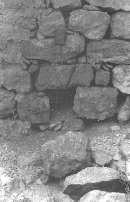 Fig. 11 Holes of missing stones in walls of adjacent rooms at the northern quarter of Shivta, resembling the
phenomenon of "bursting" of rocks in mine galleries:
Fig. 11 Holes of missing stones in walls of adjacent rooms at the northern quarter of Shivta, resembling the
phenomenon of "bursting" of rocks in mine galleries:(a) A joint in the stones above the hole of the missing stone provides an independent indication for damage during a strong earthquake Korjenkov and Mazor (1999a)  Fig. 11 Holes of missing stones in walls of adjacent rooms at the northern quarter of Shivta, resembling the
phenomenon of "bursting" of rocks in mine galleries:
Fig. 11 Holes of missing stones in walls of adjacent rooms at the northern quarter of Shivta, resembling the
phenomenon of "bursting" of rocks in mine galleries:(b,c) Rotation of stones above the holes of missing stones, providing independent proof for destruction by a strong seismic event. Korjenkov and Mazor (1999a)  Fig. 11 Holes of missing stones in walls of adjacent rooms at the northern quarter of Shivta, resembling the
phenomenon of "bursting" of rocks in mine galleries:
Fig. 11 Holes of missing stones in walls of adjacent rooms at the northern quarter of Shivta, resembling the
phenomenon of "bursting" of rocks in mine galleries:(b,c) Rotation of stones above the holes of missing stones, providing independent proof for destruction by a strong seismic event. Korjenkov and Mazor (1999a) |
Indicating "shooting" or "bursting" during strong earthquakes Figures 11a and 11b,c were photographed in adjacent rooms at the northern quarter of Shivta, depicting the phenomenon of "shooting stones". Nearly a hundred cases of such "missing" stones have been observed at Shivta. This resembles two different phenomena
In the Suusamyr earthquake mentioned, shooting of single rocks was observed within the isoseismal line of I = 8 and more. By analogy, it is suggested that the earthquake at Shivta, which caused shooting of single stones out of walls, had an intensity of at least I = 8. This is in good agreement with similar intensities concluded from other, above-described, observations, e.g., rotation of stones and other building elements, systematic collapse of walls and agricultural stone fences, high percentage of severely damaged buildings, and distances of thrown away collapse debris of agricultural fences. |
| Single stones partially pushed out of walls | Northern quarter of Shivta
Fig. 1. (c) City Plan of Shivta following Segal (1983) dots mark field stations of the present study, circles with numbers denote figure locations. Korjenkov and Mazor (1999a) |
11b
Fig. 11 Holes of missing stones in walls of adjacent rooms at the northern quarter of Shivta, resembling the
phenomenon of "bursting" of rocks in mine galleries: (b,c) Rotation of stones above the holes of missing stones, providing independent proof for destruction by a strong seismic event. Korjenkov and Mazor (1999a)
Fig. 11 Holes of missing stones in walls of adjacent rooms at the northern quarter of Shivta, resembling the
phenomenon of "bursting" of rocks in mine galleries:(b,c) Rotation of stones above the holes of missing stones, providing independent proof for destruction by a strong seismic event. Korjenkov and Mazor (1999a) |
Indicating damage by a strong seismic event Figures 11b,c show not only holes of bursted out stones, but also reveal stones that were partially pushed out of the wall. For example, stones No. 7, 8, 9, 10, 13, 16, 19 (Figs. 11b,c) are pulled out southward 2.5-26.0 cm. Such pushed stones provide by them-selves a criterion of seismic damage. |
| Vertical joints passing through few adjacent stones | 12a is in West Central Quarter 12b in Northern Church 13b in South Church
Fig. 1. (c)City Plan of Shivta following Segal (1983) dots mark field stations of the present study, circles with numbers denote figure locations. Korjenkov and Mazor (1999a) |
12a 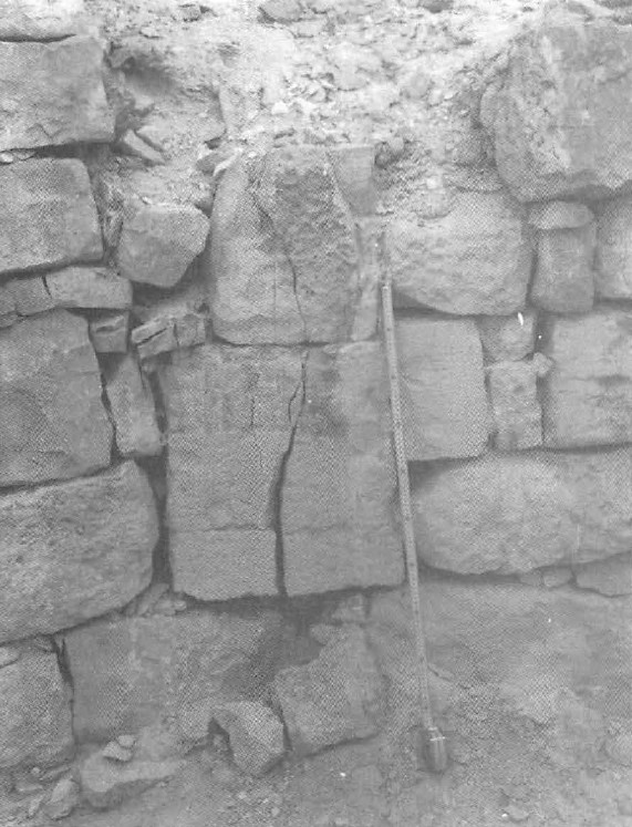 Fig. 12 Through-going joints at Shivta:
(a) A wall at the courtyard at the west—central quarter Korjenkov and Mazor (1999a)  Fig. 12 Through-going joints at Shivta:
(b) Pedestal of a column of the Northern Church. Korjenkov and Mazor (1999a)  Fig. 13. Cracks in structures in Shivta that carry no load:
(b) A crack in the doorpost of the SW room of the South Church. Korjenkov and Mazor (1999a) |
Minimum earthquake intensity I= 8x MSK-64 scale The definition of damage patterns caused by earth-quakes of intensity I = 7 (MSK-64 scale) includes joints crossing a few adjacent high-quality bricks. The reason that such through-going joints are formed only as a result of high-intensity earthquakes is understandable in light of the high energy necessary to overcome the stress shadows of free surfaces at the stone margins (i.e., the free space between adjacent stones) as described by Fisher et al. (1995), Engelder and Fisher (1996), Becker and Gross (1996). Figures 12a,b depict through-going joints, not in bricks, but in hard limestone stones, and hence, the intensity of the damaging earthquake must have been higher than the I = 7, quoted for bricks. This is in agreement with other criteria that indicate that the earthquake that damaged Shivta was at least I = 8. It is important to note that these cracks occur in stair-cases and doorsteps that by origin carried no load and in a doorpost of the type shown in Fig. 13b, which is shielded by an overlying arch-like structure. The lack of overload rules out static damage in these cases and makes seismic destruction evident. |
| Cracked doorsteps, staircases, and doorposts | 13a in North Church 13b in South Church
Fig. 1. (c)City Plan of Shivta following Segal (1983) dots mark field stations of the present study, circles with numbers denote figure locations. Korjenkov and Mazor (1999a) |
13a  Fig. 13. Cracks in structures in Shivta that carry no load:
(a) Cracked upper step of a staircase at the North Church Korjenkov and Mazor (1999a)
Fig. 13. Cracks in structures in Shivta that carry no load:(b) A crack in the doorpost of the SW room of the South Church. Korjenkov and Mazor (1999a) |
Cracks in structures in Shivta that carry no load |
| Upper parts of buildings more damaged than lower parts | Southwest quarter
Fig. 1. (c) City Plan of Shivta following Segal (1983) dots mark field stations of the present study, circles with numbers denote figure locations. Korjenkov and Mazor (1999a) |
14
Fig. 14 Two-floor structure at the southwest quarter, Shivta, that reveals more destruction in its upper part. This is the "skyscraper effect". Korjenkov and Mazor (1999a) |
The "skyscraper effect" The arches and roof slabs seen in Fig. 14 mark the ground floor of a building, and the overlying walls are the reminders of the second floor. In this case severe damage is seen in the upper part of the building, as compared to little damage in the lower part. This observation resembles the well-known "skyscraper effect" that results from the higher degree of oscillations of the higher part of the structure. A higher degree of destruction of upper parts of structures at Shivta is the rule, providing an independent reflection of seismically-induced damage. |
| Special walls supporting constructions that were tilted by a former earthquake | wall of a house at the west—central quarter | 15
Fig. 15 A supporting wall (marked S.W.). It has no obvious purpose other than to support a tilted section of an original wall of a building at the west—central quarter, Shivta. Such support walls are known from other locations at Shivta as well as at Avdat, Rehovot, and Mamshit. At these locations the tilting of the original walls was caused by earthquakes (Korjenkov and Mazor, 1999b). Korjenkov and Mazor (1999a) |
Figure 15 depicts an example of a well built inclined wall that supports a tilted section of a wall of a house at the west—central quarter. Similar support walls are observable at Avdat where these walls reveal a systematic trend, indicating the supported walls were tilted by an earthquake (Korjenkov and Mazor, 1999a). Similarly, the supporting walls of Shivta seem to reflect a former earthquake, in agreement with the above-listed observations that indicate earthquake damage. In certain cases, such support walls are themselves seismically damaged, indicating a second earthquake event. |
- The ancient city of Shivta is situated on flat low-land, built of massive carbonate bedrock. Hence, no site-effects are expected to have affected the patterns of seismic damage.
- Walls of buildings and agricultural fences trending SE (130°±15°) reveal collapse
in a preferential direction towards the SW (Fig. 8), whereas walls oriented NE (40°±20°) reveal random collapse. Fig. 8
(a) Preferential collapse of a city wall in the northern quarter of Shivta (trending SE 141°); the arrival of the seismic waves was in a perpendicular direction, i.e., along a SW—NE axis
(b) Preferential collapse of an agricultural fence north of Shivta (trending SE); the arrival of the seismic wave was in a perpendicular direction, i.e., along a SW—NE axis. In both cases the collapsed stones were thrown relatively far away, up to around 8 meters; an earthquake intensity of about I = 8 is concluded
(c) Direction of clear collapse cases observed at the Byzantine walls at Shivta, as a function of wall directions: it can be seen that 15 cases of collapse toward SW have been observed on walls trending 100°-160°, whereas only 4 cases of collapse toward NE are observable in walls of the same trend. This clearly preferred orientation of collapse indicates destruction by an earthquake, and the seismic waves arrived along a NE—SW axis.
Korjenkov and Mazor (1999a) - This key observation indicates that the seismic waves arrived either from the SW (in the case of a compression wave), or from the NE, if the collapse happened in an extensional quadrangle (Korjenkov and Mazor, 1999a). In any case, the SE and NW directions of seismic wave propagation can be excluded.
- Rotations of blocks are observed at the Shivta ruins to be clockwise at walls trending NE (40°-50°),
and counterclockwise at walls trending SE (115°-130°), as shown in Fig. 6c
. Such rotations could be caused only by push movements by compression waves. Thus, the seismic waves arrived from the SW.
Fig. 6
(c) angles of rotation measured at Shivta as a function of the trend of the respective walls. Walls with a trend of 40°-50° reveal clockwise rotations, whereas the perpendicular walls with a trend of 120°-125° reveal a counterclockwise rotation. These observations indicate that the seismic waves arrived along the bisector of these trends, i.e., from the WSW.
Korjenkov and Mazor (1999a) - The Shivta ruins disclose two main perpendicular directions of walls: NE (30°-60°) and SE (120°-150°),
as can be seen in Fig. lc
. Hence, all the buildings of the Byzantine city can be modeled via a "representative room" depicted in Fig. 16
Fig. 1
(c) City plan of Shivta (following Segal, 1983) - dots mark field stations of the present study, circles with numbers denote figure locations.
Korjenkov and Mazor (1999a). Three possible scenarios warrant discussion: Fig. 16.
Modeling of expected seismic damage patterns at a representative room at Shivta, i.e., with walls trending 45° and 135°. Cones of collapse are marked as dark areas, rotated stones and wall fragments are depicted with their direction of rotation, clockwise or counterclockwise:
(a) Waves arrived from the SW, i.e., perpendicularly to the walls with a trend of 135° and parallel to the 45° walls
(b) Waves arrived from the west, at an angle of 45° to the walls of both directions
(c) Waves arrived from the WSW, i.e., at a different angle to each wall direction. The observations of directions of collapse summed up in Fig. 5 and the observation of directions of rotations summed up in Fig. 13 agree with solution (c) i.e., the seismic waves that destroyed the Byzantine buildings of Shivta arrived from the WSW.
Korjenkov and Mazor (1999a)- seismic waves arrived parallel to the NE-trending walls (Fig. 16a) — the shear stresses along the walls would be minimal, and hence no rotation would be caused, and only collapse of NW walls would be systematic
- seismic waves arrived from the west, i.e., along a line of the bisector between the wall directions—both NE and SE trending walls would reveal oriented collapse to the NW and SW sides respectively; walls with a NE trend would reveal clockwise rotation, and walls with a SE trend would reveal a more or less equal number of counterclockwise rotations
- seismic waves arrived from the WSW, i.e., at a different angle to each of the wall directions — the SE walls would manifest systematic collapse generally toward the SW, whereas the NE walls would show random collapse; rotations of elements of walls trending NE would be clockwise, whereas rotations of stones of the SE-trending walls would be counter-clockwise
- A few hundred individual observations, made at almost one hundred locations at the ancient city of Shivta, revealed the 19 types of damage patterns reported above. Part of these observations are useful in determining the axis along which the seismic waves propagated (WSW—ENE), other observations point out that the epicenter was located WSW of the city, and yet another group of observations points to an intensity of I= 8-9 (MSK-64 scale) of the earthquake that destroyed the Byzantine city in the 7th century.
- The distance of the epicenter of the earthquake that destroyed Byzantine Shivta can be estimated from the
following boundary conditions and considerations:
- the systematic pattern of destruction indicates dominance
of horizontal seismic movements, which in turn rules out the possibility that the hypocenter was beneath the city
(i.e., Shivta was not at site A of Fig. 17
)
 Fig. 16
Scheme of different patterns of seismic destruction characteristics as a function of the distance from the hypocenter. At location A, above the hypocenter, the vertical component of seismic-induced movements is dominant, resulting in no systematic destruction patterns; site B is located at an angle relative to the hypocenter, hence lateral movements are dominant with a preferred orientation of damage patterns.
Korjenkov and Mazor (1999a) - on the other hand, the dominance of a horizontal component of the seismic movements implies that the epicenter was at a distance that at least equaled the depth of the hypocenter (i.e., Shivta was at site B of Fig. 17)
- the intensity I = 8-9 (MSK-64 scale) limits the distance of the epicenter probably to less that 30 km, a conclusion that has to be checked by data from more sites from the Negev, applying the "triangulation method".
- the systematic pattern of destruction indicates dominance
of horizontal seismic movements, which in turn rules out the possibility that the hypocenter was beneath the city
(i.e., Shivta was not at site A of Fig. 17
- An attempt to locate the epicenter of the post-Byzantine earthquake at Shivta is made by applying the reconstructed WSW direction of the epicenter, and the concluded epicenter distance of a few tens of kilometers. These boundary conditions were projected on the geological map of Israel: the concluded direction of the epicenter crosses the Zin fault at a distance of 10 km, and the adjacent Nafha fault crosses with the direction of the concluded epicenter at a distance of 50 km. In any case, the results clearly point out that the epicenter was in the Negev highlands and not in the Dead Sea Rift Valley.
- The seismic damage patterns described so far were observed on buildings built in the Byzantine period and in secondary walls added later on, leading to the conclusion that at least two earthquakes damaged the Byzantine and post-Byzantine constructions.
- The described variety of seismic damage patterns provides tools to establish certain characteristics of the
involved earthquakes, e.g., seismic intensity, axis of seismic waves propagation, and in the case of systematic
rotation, also the specific direction of the epicenter. In a more advanced stage of the archeoseismological study,
the investigations in individual sites can be put together into a regional picture that provides more
definite answers on the nature of the studied earthquakes. For example, the Negev data from several ancient
ruin centers may be compiled, e.g., Mamshit, Avdat, Rehovot, Haluza, Hurvat Sa'adon, Shivta, and Nizzana (Fig. 1
). In other words, the triangulation approach is recommended (Korjenkov and Mazor, 1999a , 1999b).
 Fig. 1
(a) Ancient cities of the central Negev and main trade routes; following Segal (1983) and Russell (1980)
Korjenkov and Mazor (1999a) - The common descriptions of damage patterns typifying different earthquake intensities are based on the inventory of modern buildings. The present work brings up additional damage patterns observed in ancient architectural complexes, e.g., damage pattern of stone arches, systematic tilt, collapse and rotation of stone building elements, the distance to which collapse debris is thrown away from the respective foundation, as well as preferential collapse of colonnades observed in many published case studies.
- The described archeoseismological study has modern applications in regard to specifications of seismic safety to be taken into account in new constructions in the Negev highlands.
- Finally, the described archeoseismological work lends itself to inter-regional and international collaboration in the construction of a seismic archive that goes back thousands of years.
- Modified by JW from Fig. ? of Hirschfeld (2003)
 Deformation Map
modified by JW from Fig. ? of Hirschfeld (2003)
- Modified by JW from Fig. 3 of Erickson-Gini (2013)
 Deformation Map
modified by JW from Fig. 3 of Erickson-Gini (2013)
- Earthquake Archeological Effects chart
of Rodríguez-Pascua et al (2013: 221-224)
 Earthquake Archeological Effects (EAE)
Rodríguez-Pascua et al (2013: 221-224)
| Effect | Location | Figure | Comments | Intensity |
|---|---|---|---|---|
| Displaced or Folded Walls - Revetment Wall suggesting wall damage | Northern and southern churches
Fig. 1. (b) A map of Shivta following Segal (1983) Korjenkov and Mazor (1999a) |
|
VII + |
- Earthquake Archeological Effects chart
of Rodríguez-Pascua et al (2013: 221-224)
Earthquake Archeological Effects (EAE)
Rodríguez-Pascua et al (2013: 221-224)
| Effect | Location | Figure | Comments | Intensity |
|---|---|---|---|---|
| Displaced or Folded Walls - Revetment Wall suggesting wall damage | location not specified | 15
Fig. 15 A supporting wall (marked S.W.). It has no obvious purpose other than to support a tilted section of an original wall of a building at the west—central quarter, Shivta. Such support walls are known from other locations at Shivta as well as at Avdat, Rehovot, and Mamshit. At these locations the tilting of the original walls was caused by earthquakes (Korjenkov and Mazor, 1999b). Korjenkov and Mazor (1999a) |
Figure 15 depicts an example of a well built inclined wall that supports a tilted section of a wall of a house at the west—central quarter. Similar support walls are observable at Avdat where these walls reveal a systematic trend, indicating the supported walls were tilted by an earthquake (Korjenkov and Mazor, 1999a). Similarly, the supporting walls of Shivta seem to reflect a former earthquake, in agreement with the above-listed observations that indicate earthquake damage. In certain cases, such support walls are themselves seismically damaged, indicating a second earthquake event.- Korjenkov and Mazor (1999a) |
VII + |
| Displaced or Folded Walls - Revetment Wall suggesting wall damage | Western wall of Building 123 |
|
VII + |
- Earthquake Archeological Effects chart
of Rodríguez-Pascua et al (2013: 221-224)
Earthquake Archeological Effects (EAE)
Rodríguez-Pascua et al (2013: 221-224)
| Effect | Location | Figure | Comments | Intensity |
|---|---|---|---|---|
| Wall and Ceiling collapse | Room 2 in Building 121
Fig. 3 Building 121, plan and section of the 2009 excavation. Erickson-Gini (2013) |
Fig. 8 Room 2, section showing earthquake collapse, looking east Erickson-Gini (2013) |
collapse of the ceilings and parts of the walls- Erickson-Gini (2013) |
VIII + |
| Collapsed Wall | Wall 1 in Courtyard of Building 121
Fig. 3 Building 121, plan and section of the 2009 excavation. Erickson-Gini (2013) |
Fig. 5 Collapse of W1 in the courtyard, looking southwest Erickson-Gini (2013) |
Collapse of W1 in the courtyard- Erickson-Gini (2013) |
VIII + |
| Arch Collapse | Room 2 along W2 of Building 121
Fig. 3 Building 121, plan and section of the 2009 excavation. Erickson-Gini (2013) |
Fig. 7 Room 2, collapsed arches and ceiling slabs along W2, looking west. Erickson-Gini (2013) |
collapsed arches and ceiling slabs- Erickson-Gini (2013) |
VI + |