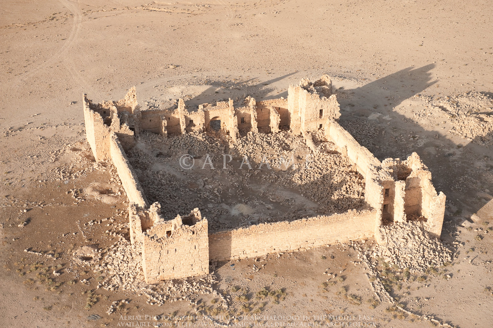
Qasr Bshir
APAAME
- Reference: APAAME_20081008_DLK-0009
- Photographer: David Leslie Kennedy
- Credit: Aerial Photographic Archive for Archaeology in the Middle East
- Copyright: Creative Commons Attribution-Noncommercial-No Derivative Works
| Transliterated Name | Language | Name |
|---|---|---|
| Qasr Bshir | Arabic | قاسر بسهير |
| Castra Praetorii Mobeni | Latin |
- Plate 71 - Latin Building Inscription
on lintel of gateway of Qasr Bshir from Parker (1987)
 Pl. 71
Latin Building Inscription on lintel of gateway of Qasr Bshir
JW: Note the two fractures in the lintel and the chipped corners in the stones above the lintel
Parker (1987)
The Castellum of Qasr Bshir is located ~15 km. NE of el-Lejjun and ~15 km. NW of the modern town of el-Qatrana. A Latin inscription on a lintel stone within a
tabula ansata over the main gateway (see Figures) provides a date for construction of the fort between 293 and 305 CE ( Clark, 1987). This date is also supported by the earliest coin from the site (Coin #15 from H.5:008) which was dated to 310-325 CE ( Clark, 1987).
A small but significant number of Iron Age and Nabataean sherds indicates earlier activity( Clark, 1987). This material was not found in
in situ occupational deposits, although such [deposits] may exist( Clark, 1987). The site was abandoned by the Romans by 500 CE. After abandonment, limited occupation occurred which
may have been no more than a squatter occupation. The site was re-occupied in the Umayyad period. After abandonment at the end of the Umayyad period, transitory occupation followed up to the present day ( Clark, 1987).
- Map of Limes Arabicus
Fortresses in Jordan from Wikipedia
 Limes arabicus, central part in Jordan - Azraq basin and Wadi el-Mujib basin. Red squares are
Roman fortresses and forts from the end of the 3rd/beginning of the 4th century.
Limes arabicus, central part in Jordan - Azraq basin and Wadi el-Mujib basin. Red squares are
Roman fortresses and forts from the end of the 3rd/beginning of the 4th century.
(modified from S. T. Parker, An Empire's New Holy Land: The Byzantine Perio, Near Eastern Archaeology , Sep., 1999, Vol. 62, No. 3 (Sep., 1999), p. 138)
Ursus - Wikipedia - CC-BY-SA 4.0 - Qasr Bshir in Google Earth
 Qasr Bshir
click on image to explore this site on a new tab in Google Earth
- Fig. 87 - Site Plan from
Clark (1987)
 Fig. 87
General location map of Qasr Bshir
Parker (1987) - Fig. 88 - Plan of the Castellum
with survey areas from Clark (1987)
 Fig. 88
Plan of Qasr Bshir with soundings - 1980-89
Annotations of survey areas (in red) added by JW
Parker (1987) - Plan of the Castellum
from Wikipedia

Plan of the Castellum
Click on image to open a high res magnifiable version in a new tab
Castra Praetorii Mobeni at Limes Arabicus in a plan compiled by user Mediatus. The research of Alfred von Domaszewski (1856–1927) and Rudolf Ernst Brünnow (1858–1917) was particularly used for this plan: The Provincia Arabia was described on the basis of two trips undertaken in 1897 and 1898 and the reports of previous travelers. Volume 2, Trübner, Strasbourg 1904, pp. 48, 49 (fold-out plan; taken by Alfred von Domaszewski). Samuel Thomas Parker (1950–2021): The Roman Limes in Jordan also played an important role. In: Studies in the History and Archeology of Jordan 3 (1987), pp. 151–164; here: p. 157, Fig. 6. This revised and corrected plan was originally drawn by Bert de Vries (1939–2021) in his capacity as an architect based on the plan by Domaszewski and Brünnow. The architects Jim Michener and Dan Ritsema helped de Vies as surveyors. The plan created here on Wikipedia by the user Mediatus also differs from the two compilations mentioned in that it shows the angle measurements, which are not always straight.
Mediatus (H.J.) - Wikipedia - CC-BY-SA-3.0 & GFDL

- Fig. 87 - Site Plan from
Clark (1987)
Fig. 87
General location map of Qasr Bshir
Parker (1987) - Fig. 88 - Plan of the Castellum
with survey areas from Clark (1987)
Fig. 88
Plan of Qasr Bshir with soundings - 1980-89
Annotations of survey areas (in red) added by JW
Parker (1987) - Plan of the Castellum
from Wikipedia
Plan of the Castellum
Click on image to open a high res magnifiable version in a new tab
Castra Praetorii Mobeni at Limes Arabicus in a plan compiled by user Mediatus. The research of Alfred von Domaszewski (1856–1927) and Rudolf Ernst Brünnow (1858–1917) was particularly used for this plan: The Provincia Arabia was described on the basis of two trips undertaken in 1897 and 1898 and the reports of previous travelers. Volume 2, Trübner, Strasbourg 1904, pp. 48, 49 (fold-out plan; taken by Alfred von Domaszewski). Samuel Thomas Parker (1950–2021): The Roman Limes in Jordan also played an important role. In: Studies in the History and Archeology of Jordan 3 (1987), pp. 151–164; here: p. 157, Fig. 6. This revised and corrected plan was originally drawn by Bert de Vries (1939–2021) in his capacity as an architect based on the plan by Domaszewski and Brünnow. The architects Jim Michener and Dan Ritsema helped de Vies as surveyors. The plan created here on Wikipedia by the user Mediatus also differs from the two compilations mentioned in that it shows the angle measurements, which are not always straight.
Mediatus (H.J.) - Wikipedia - CC-BY-SA-3.0 & GFDL
- Reconstruction of Castellum
from Campbell (2009)
 Reconstruction of Castellum of Qasr Bshir
Campbell (2009:58)
- Fig. 89 - Northeast balk section
of Squares H.1 and H.6 from Clark (1987)
 Fig. 89
Northeast balk section of Squares H.1 and H.6 at Qasr Bshir
Parker (1987)
- Pl. 74 - Interior of southwest corner tower
from Clark (1987)
 Plate 74
Interior of southwest corner tower of Qasr Bshir
Parker (1987) - Pl. 75 - Interior view of Qasr Bshir
from Clark (1987)
 Plate 75
Interior view of Qasr Bshir
Parker (1987) - Pl. 78 - Stone pier with
original courtyard surface from Clark (1987)
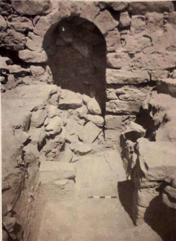 Plate 78
Stone pier with original courtyard surface in Qasr Bshir
Parker (1987)
- Fig. 88 - Plan of the Castellum
with survey areas from Clark (1987)
Fig. 88
Plan of Qasr Bshir with soundings - 1980-89
Annotations of survey areas (in red) added by JW
Parker (1987)
- Fig. 88 - Plan of the Castellum
with survey areas from Clark (1987)
Fig. 88
Plan of Qasr Bshir with soundings - 1980-89
Annotations of survey areas (in red) added by JW
Parker (1987)
- Fig. 88 - Plan of the Castellum
with survey areas from Clark (1987)
Fig. 88
Plan of Qasr Bshir with soundings - 1980-89
Annotations of survey areas (in red) added by JW
Parker (1987)
- Fig. 88 - Plan of the Castellum
with survey areas from Clark (1987)
Fig. 88
Plan of Qasr Bshir with soundings - 1980-89
Annotations of survey areas (in red) added by JW
Parker (1987)
| Effect | Location | Image(s) | Description |
|---|---|---|---|
|
barrack walls (H.2:001 and 002)
Fig. 88 Plan of Qasr Bshir with soundings - 1980-89 Annotations of survey areas (in red) added by JW Parker (1987) |
"Stones of the adjacent barrack walls (H.2:001 and 002) were charred at this level. This may represent a localized fire or possibly extensive conflagration, perhaps the result of the 363 earthquake (note also the ash in H.1:012, 014, and 015). Ceramics from this ash were predominantly Late Roman IV to Early Byzantine, but a query is raised by a single sherd which may be Umayyad" - Clark (1987) |
| Effect | Location | Image(s) | Description |
|---|---|---|---|
| Rock Tumble | H.1
Fig. 88 Plan of Qasr Bshir with soundings - 1980-89 Annotations of survey areas (in red) added by JW Parker (1987) |
Fig. 89 Northeast balk section of Squares H.1 and H.6 at Qasr Bshir Parker (1987) |
In H.1 a 0.25 m deposit of rock tumble and windblown loess (H.1:010 and 011) overlay the Early Byzantine I-II occupational deposits- Clark (1987) |
| Building Collapse | H.1
Fig. 88 Plan of Qasr Bshir with soundings - 1980-89 Annotations of survey areas (in red) added by JW Parker (1987) |
This appears to represent a period of abandonment and of building collapse.- Clark (1987) |
- Only the better dated seismic effects are listed
| Effect | Location | Image(s) | Description |
|---|---|---|---|
| Wall Collapse | H.1 and H.6 - The barracks rooms along the southwest side
Fig. 88 Plan of Qasr Bshir with soundings - 1980-89 Annotations of survey areas (in red) added by JW Parker (1987) |
The archaeological record from H.1, H.3, and H.6 suggests that the major collapse took place either during or soon after the Umayyad occupation. In H.1 and H.6 the collapse lay directly over the occupation of this period in the courtyard. There the walls of the barracks rooms along the southwest side had fallen to the northeast, into the courtyard.- Clark (1987) |
|
| Wall Collapse | H.3
Fig. 88 Plan of Qasr Bshir with soundings - 1980-89 Annotations of survey areas (in red) added by JW Parker (1987) |
Elsewhere the rooms seem to have collapsed in upon themselves, as in H.3, where the upper floor had fallen into the ground floor room- Clark (1987) |
|
| Upper Story Collapse | H.3
Fig. 88 Plan of Qasr Bshir with soundings - 1980-89 Annotations of survey areas (in red) added by JW Parker (1987) |
This collapse included flat roofing beams, what appeared to be flat flooring slabs of limestone, masonry blocks, chinking stones, cobbles, plaster, and mortar.- Clark (1987) |
|
| Human remains | H.1
Fig. 88 Plan of Qasr Bshir with soundings - 1980-89 Annotations of survey areas (in red) added by JW Parker (1987) |
the presence of some human bones here is not easy to explain; they may be the partial remains of a person (or persons) killed in the earthquake that seems to have put an end to the Umayyad occupation.- Clark (1987) |
| Effect | Location | Image(s) | Description |
|---|---|---|---|
| Masonry Collapse | H.2:004
Fig. 88 Plan of Qasr Bshir with soundings - 1980-89 Annotations of survey areas (in red) added by JW Parker (1987) |
There followed a major collapse of masonry, after which no further occupation of the room took place- Clark (1987) |
- Earthquake Archeological Effects chart
of Rodríguez-Pascua et al (2013: 221-224)
 Earthquake Archeological Effects (EAE)
Rodríguez-Pascua et al (2013: 221-224)
| Effect | Location | Image(s) | Description | Intensity |
|---|---|---|---|---|
| Collapsed Walls - Rock Tumble | H.1
Fig. 88 Plan of Qasr Bshir with soundings - 1980-89 Annotations of survey areas (in red) added by JW Parker (1987) |
Fig. 89 Northeast balk section of Squares H.1 and H.6 at Qasr Bshir Parker (1987) |
In H.1 a 0.25 m deposit of rock tumble and windblown loess (H.1:010 and 011) overlay the Early Byzantine I-II occupational deposits- Clark (1987) |
VIII + |
| Collapsed Walls - Building Collapse | H.1
Fig. 88 Plan of Qasr Bshir with soundings - 1980-89 Annotations of survey areas (in red) added by JW Parker (1987) |
This appears to represent a period of abandonment and of building collapse.- Clark (1987) |
VIII + |
- Only the better dated seismic effects are listed
- Earthquake Archeological Effects chart
of Rodríguez-Pascua et al (2013: 221-224)
Earthquake Archeological Effects (EAE)
Rodríguez-Pascua et al (2013: 221-224)
| Effect | Location | Image(s) | Description | Intensity |
|---|---|---|---|---|
| Wall Collapse | H.1 and H.6 - The barracks rooms along the southwest side
Fig. 88 Plan of Qasr Bshir with soundings - 1980-89 Annotations of survey areas (in red) added by JW Parker (1987) |
the walls of the barracks rooms along the southwest side had fallen to the northeast, into the courtyard- Clark (1987) |
VIII + | |
| Wall Collapse | H.3
Fig. 88 Plan of Qasr Bshir with soundings - 1980-89 Annotations of survey areas (in red) added by JW Parker (1987) |
Elsewhere the rooms seem to have collapsed in upon themselves, as in H.3, where the upper floor had fallen into the ground floor room- Clark (1987) |
VIII + | |
| Wall Collapse - Upper Story Collapse | H.3
Fig. 88 Plan of Qasr Bshir with soundings - 1980-89 Annotations of survey areas (in red) added by JW Parker (1987) |
This collapse included flat roofing beams, what appeared to be flat flooring slabs of limestone, masonry blocks, chinking stones, cobbles, plaster, and mortar.- Clark (1987) |
VIII + |
- Earthquake Archeological Effects chart
of Rodríguez-Pascua et al (2013: 221-224)
Earthquake Archeological Effects (EAE)
Rodríguez-Pascua et al (2013: 221-224)
| Effect | Location | Image(s) | Description | Intensity |
|---|---|---|---|---|
| Collapsed Walls - Masonry Collapse | H.2:004
Fig. 88 Plan of Qasr Bshir with soundings - 1980-89 Annotations of survey areas (in red) added by JW Parker (1987) |
There followed a major collapse of masonry, after which no further occupation of the room took place- Clark (1987) |
VIII + |