Hammat Gader
 Hammat Gader (חמת גדר)
click on image to explore this site on a new tab in google earth
| Transliterated Name | Source | Name |
|---|---|---|
| Hammat Gader | Hebrew | חַמַּת גָּדֵר |
| Hammata degader | Rabbinic Sources | |
| Hammat deGader | Aramaic | חחמתא דגדר |
| ema deGader | Syriac | |
| Al-Hamma | Aramaic | الحمّة |
| al-hamma al-souriya | Arabic | الحمة السورية |
| Emmatha | Ancient Greek | Ἑμμαθά |
| Amatha | Ancient Greek | Αμαθα |
| Hammeh | Arabic |
- Fig. 1 Location Map
from Hirschfeld et al. (1997)
 Fig. 1
Map of area around Hammat Gader
Hirschfeld et al. (1997) - Fig. 1 The Plain of
El-Hammeh from Sukenik (1935)
 Fig. 1
The Plain of el-Hammeh (according to Schumacher)
Sukenik (1935) - Fig. 2 Geologic Sketch
of el-Hammeh from Sukenik (1935)
 Fig. 2
Geologic Sketch of el-Hammeh
Sukenik (1935)
- Fig. 1 Location Map
from Hirschfeld et al. (1997)
Fig. 1
Map of area around Hammat Gader
Hirschfeld et al. (1997) - Fig. 1 The Plain of
El-Hammeh from Sukenik (1935)
Fig. 1
The Plain of el-Hammeh (according to Schumacher)
Sukenik (1935) - Fig. 2 Geologic Sketch
of el-Hammeh from Sukenik (1935)
Fig. 2
Geologic Sketch of el-Hammeh
Sukenik (1935)
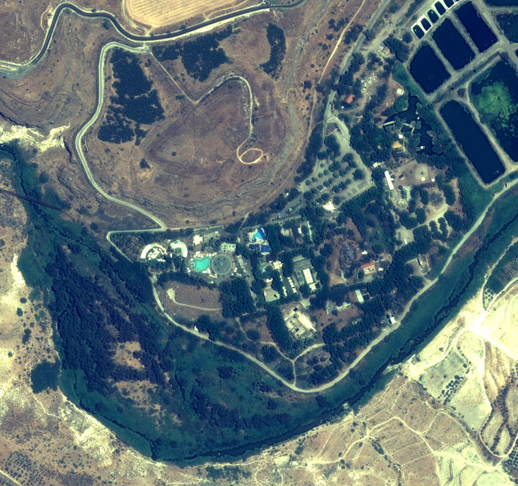
- Annotated Satellite Image
of Hammat Gader and environs from biblewalks.com
 Annotated Satellite Image (google) of Hammat Gader and environs
Used with permission from BibleWalks.com - Plate I View of El-Hammeh
from Sukenik (1935)
 Plate I
General view of el-Hammeh front the North. Below is seen the Yarmuk River crossed by the bridge of the Hedjaz Railway; on the left appears the hill upon which the Synagogue stood; on the top of the mountains in the centre is the site of ancient Gadara.
Sukenik (1935) - Hammat Gader in Google Earth
Hammat Gader (חמת גדר)
click on image to explore this site on a new tab in Google Earth - Hammat Gader on govmap.gov.il
 Hammat Gader
click on image to explore this site on a new tab in govmap.gov.il
- Annotated Satellite Image
of Hammat Gader and environs from biblewalks.com
Annotated Satellite Image (google) of Hammat Gader and environs
Used with permission from BibleWalks.com - Plate I View of El-Hammeh
from Sukenik (1935)
Plate I
General view of el-Hammeh front the North. Below is seen the Yarmuk River crossed by the bridge of the Hedjaz Railway; on the left appears the hill upon which the Synagogue stood; on the top of the mountains in the centre is the site of ancient Gadara.
Sukenik (1935)
- Fig. 3 Site Plan
from Hirschfeld et al. (1997)
 Fig. 3
Plan of Hammat Gader and its springs.
- 'Ain el-Maqleh
- ‘Ain er-Rih
- ‘Ain el-Jarab
- ‘Ain Bulos
- ‘Ain Sa’ad el-Rar
Hirschfeld et al. (1997) - Fig. 7 Reconstructed
Site Plan from Hirschfeld et al. (1997)
 Fig. 7
Reconstructed plan of ancient Hammat Gader
Hirschfeld et al. (1997)
- Fig. 3 Site Plan
from Hirschfeld et al. (1997)
Fig. 3
Plan of Hammat Gader and its springs.
- 'Ain el-Maqleh
- ‘Ain er-Rih
- ‘Ain el-Jarab
- ‘Ain Bulos
- ‘Ain Sa’ad el-Rar
Hirschfeld et al. (1997) - Fig. 7 Reconstructed Site Plan
from Hirschfeld et al. (1997)
Fig. 7
Reconstructed plan of ancient Hammat Gader
Hirschfeld et al. (1997)
- Fig. 11 General
plan of the remains of the baths exposed in the excavations from Hirschfeld et al. (1997)
 Fig. 11
General plan of the remains of the baths exposed in the excavations
Hirschfeld et al. (1997) - Fig. 39 Plan of
the water system of the Hammat Gader baths from Hirschfeld et al. (1997)
 Fig. 39
Plan of the water system of the Hammat Gader baths.
Hirschfeld et al. (1997) - Plan of the baths from
Stern et. al. (1993 v.2)
 Plan of the baths
Stern et. al. (1993 v.2) - Fig. 51 Partial
Reconstruction of the baths complex from Hirschfeld et al. (1997)
 Fig. 51
Partial Reconstruction of the baths complex, with identification of excavation areas and the conjectured bathing route (marked by arrows).
Hirschfeld et al. (1997) - Fig. 252 Partial
reconstruction of the baths structure from Hirschfeld et al. (1997)
 Fig. 252
Partial reconstruction of the baths structure, looking north
Hirschfeld et al. (1997) - Fig. 253 Proposed
plan of the entire baths complex from Hirschfeld et al. (1997)
 Fig. 253
Proposed plan of the entire baths complex
Hirschfeld et al. (1997) - Fig. 254 Reconstruction
of the roofs of the baths building from Hirschfeld et al. (1997)
 Fig. 254
Reconstruction of the roofs of the baths building, looking west
Hirschfeld et al. (1997)
- Fig. 11 General
plan of the remains of the baths exposed in the excavations from Hirschfeld et al. (1997)
Fig. 11
General plan of the remains of the baths exposed in the excavations
Hirschfeld et al. (1997) - Fig. 39 Plan of
the water system of the Hammat Gader baths from Hirschfeld et al. (1997)
Fig. 39
Plan of the water system of the Hammat Gader baths.
Hirschfeld et al. (1997) - Plan of the baths from
Stern et. al. (1993 v.2)
Plan of the baths
Stern et. al. (1993 v.2) - Fig. 51 Partial
Reconstruction of the baths complex from Hirschfeld et al. (1997)
Fig. 51
Partial Reconstruction of the baths complex, with identification of excavation areas and the conjectured bathing route (marked by arrows).
Hirschfeld et al. (1997) - Fig. 252 Partial
reconstruction of the baths structure from Hirschfeld et al. (1997)
Fig. 252
Partial reconstruction of the baths structure, looking north
Hirschfeld et al. (1997) - Fig. 253 Proposed
plan of the entire baths complex from Hirschfeld et al. (1997)
Fig. 253
Proposed plan of the entire baths complex
Hirschfeld et al. (1997) - Fig. 254 Reconstruction
of the roofs of the baths building from Hirschfeld et al. (1997)
Fig. 254
Reconstruction of the roofs of the baths building, looking west
Hirschfeld et al. (1997)
- Fig. 103 Detailed
Plan of Area A (Oval Hall) from Hirschfeld et al. (1997)
 Fig. 103
Detailed Plan of Area A (Oval Hall).
Hirschfeld et al. (1997) - Fig. 188 Detailed
Plan of the remains of the late periods in Area B (passage rooms) from Hirschfeld et al. (1997)
 Fig. 188
Detailed plan of the remains of the late periods in Area B (passage rooms).
Hirschfeld et al. (1997) - Fig. 65 Detailed
Plan of Area C (Hall of Piers) from Hirschfeld et al. (1997)
 Fig. 65
Detailed Plan of Area C (Hall of Piers).
Hirschfeld et al. (1997) - Fig. 178 Byzantine
tiled floor and the late remains north of the columned portal [in Area C] from Hirschfeld et al. (1997)
 Fig. 178
Plan of the Byzantine tiled floor and the late remains north of the columned portal [in Area C]
Hirschfeld et al. (1997) - Fig. 135 Detailed
Plan of Area D (Hall of Fountains) from Hirschfeld et al. (1997)
 Fig. 135
Detailed plan of Area D (Hall of Fountains)
Hirschfeld et al. (1997) - Fig. 85 Detailed
Plan of Area E (Hall of Inscriptions) from Hirschfeld et al. (1997)
 Fig. 85
Detailed Plan of Area E (Hall of Inscriptions).
Hirschfeld et al. (1997) - Fig. 52 Detailed
Plan of Area H (Entrance Corridor) from Hirschfeld et al. (1997)
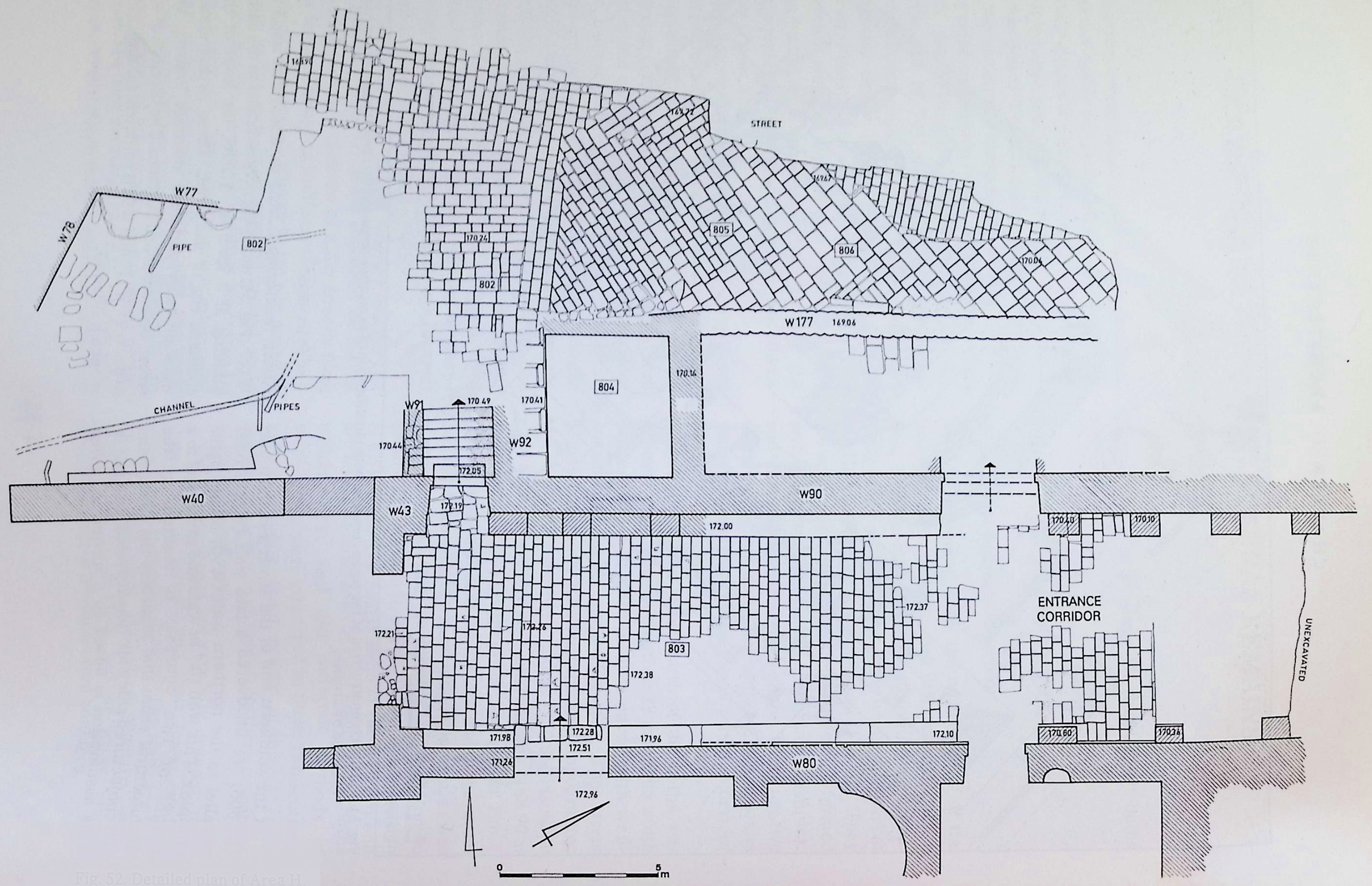 Fig. 52
Detailed Plan of Area H
Hirschfeld et al. (1997)
- Fig. 103 Detailed
Plan of Area A (Oval Hall) from Hirschfeld et al. (1997)
Fig. 103
Detailed Plan of Area A (Oval Hall).
Hirschfeld et al. (1997) - Fig. 188 Detailed
Plan of the remains of the late periods in Area B (passage rooms) from Hirschfeld et al. (1997)
Fig. 188
Detailed plan of the remains of the late periods in Area B (passage rooms).
Hirschfeld et al. (1997) - Fig. 65 Detailed
Plan of Area C (Hall of Piers) from Hirschfeld et al. (1997)
Fig. 65
Detailed Plan of Area C (Hall of Piers).
Hirschfeld et al. (1997) - Fig. 178 Byzantine
tiled floor and the late remains north of the columned portal [in Area C] from Hirschfeld et al. (1997)
Fig. 178
Plan of the Byzantine tiled floor and the late remains north of the columned portal [in Area C]
Hirschfeld et al. (1997) - Fig. 125 Detailed
Plan of Area D (Hall of Fountains) from Hirschfeld et al. (1997)
Fig. 135
Detailed plan of Area D (Hall of Fountains)
Hirschfeld et al. (1997) - Fig. 85 Detailed
Plan of Area E (Hall of Inscriptions) from Hirschfeld et al. (1997)
Fig. 85
Detailed Plan of Area E (Hall of Inscriptions).
Hirschfeld et al. (1997) - Fig. 52 Detailed
Plan of Area H (Entrance Corridor) from Hirschfeld et al. (1997)
Fig. 52
Detailed Plan of Area H
Hirschfeld et al. (1997)
 Fig. 1
Plan of the baths complex with location of inscriptions, arrows show orientation of each inscription.
Hirschfeld et al. (1997)
- Fig. 2 Parts of the
columned portal as found in the excavation from Hirschfeld et al. (1997)
 Fig. 2
Parts of the columned portal as found in the excavation, looking northwest.
Hirschfeld et al. (1997) - Plate I The apparently
restored columned portal from Hirschfeld et al. (1997)
 Plate I
Columned portal in Area C. looking north
Hirschfeld et al. (1997) - Fig. 5 Remains of
arches and vaults in the baths building, as photographed in the early 20th century from Hirschfeld et al. (1997)
 Fig. 5
Remains of arches and vaults in the baths building, as photographed in the early 20th century, looking east
(Antiquities Authority Archive)
Hirschfeld et al. (1997) - Fig. 10 Remains of
baths at the conclusion of excavations (1982) from Hirschfeld et al. (1997)
 Fig. 10
Remains of the baths at the conclusion of excavations (1982), looking south
Hirschfeld et al. (1997) - Fig. 8 Collapsed
Vault from Area D from Hirschfeld et al. (1997)
 Fig. 8
Remains of a vault found in the debris of Area D (Hall of Fountains), looking north.
Hirschfeld et al. (1997) - Fig. 18 Section of
the ceiling vault in Area A (Oval Hall) that fell directly on the pool floor from Hirschfeld et al. (1997)
 Fig. 18
Section of the ceiling vault in Area A (Oval Hall) that fell directly on the pool floor, looking east.
Hirschfeld et al. (1997) - Fig. 84 Photograph
of the roof debris of Area C (Hall of Piers) from Hirschfeld et al. (1997)
 Fig. 84
Photograph of the roof debris of Area C (Hall of Piers), looking south
Hirschfeld et al. (1997) - Fig. 84 Cross section
(across the width) of the roof debris of Area C (Hall of Piers) from Hirschfeld et al. (1997)
 Fig. 84
Cross section (across the width) of the roof debris of Area C (Hall of Piers), looking south
Hirschfeld et al. (1997) - Fig. 87 The southern end
of Area A (Hall of Inscriptions), including the southern wall (W1) from Hirschfeld et al. (1997)
 Fig. 87
The southern end of Area A (Hall of Inscriptions), including the southern wall (W1), looking south
Hirschfeld et al. (1997) - Fig. 88 Drawing of
the northern face of Wall W1 (separating Areas E and B) from Hirschfeld et al. (1997)
 Fig. 88
View of the northern face of Wall W1 (Areas E and B)
Hirschfeld et al. (1997) - Fig. 95 Debris of
vault stones on the floor of Area E (Hall of Inscriptions) from Hirschfeld et al. (1997)
 Fig. 95
Debris of vault stones on the floor of Area E (Hall of Inscriptions), looking southeast.
Hirschfeld et al. (1997) - Fig. 159 Debris of
the vault on the floor of of the central pool of Area D (Hall of Fountains) from Hirschfeld et al. (1997)
 Fig. 159
Debris of the vault on the floor of of the central pool of Area D (Hall of Fountains), looking northwest.
Hirschfeld et al. (1997) - Fig. 160 Remains of
the vault of the southern wing found in the alluvium on the floor of the hall from Hirschfeld et al. (1997)
 Fig. 160
Remains of the vault of the southern wing found in the alluvium on the floor of the hall, looking north.
Hirschfeld et al. (1997) - Fig. 118 Fountain
found in the alluvium above the central pool of Area A (Oval Hall) from Hirschfeld et al. (1997)
 Fig. 118
Another fountain found in the alluvium above the central pool of Area A (Oval Hall). JW: Although this fountain was found atop alluvium, four fountains were reported by Hirschfeld et al. (1997:92) as being found "in debris"
Hirschfeld et al. (1997) - Fig. 177 Secondary Use
of architectural elements in Wall W92 in Byzantine Phase II Area H (Entrance Corridor) from Hirschfeld et al. (1997)
 Fig. 177
Eastern face of W92 next to the staircase descending to the baths, looking southwest. Note the secondary use of architectural elements.
Hirschfeld et al. (1997) - Fig. 179 Inscription No. 1
in Area C Byzantine Phase II from Hirschfeld et al. (1997)
 Fig. 179
Inscription No. 1 found in situ, looking south. Note the Byzantine floor tiles framing the inscription
Hirschfeld et al. (1997) - Fig. 180 Lateral cross
section showing central pool of Area C beneath Byzantine Phase II flooring from Hirschfeld et al. (1997)
 Fig. 180
Lateral cross section of the central pool of Area C (Hall of Piers) and the bathtub west of it (L.325)
Hirschfeld et al. (1997) - Fig. 184 Dented (?) Marble
Floor in Area E from Hirschfeld et al. (1997)
 Fig. 184
Marble floor of Area E (Hall of Inscriptions) looking south
Hirschfeld et al. (1997) - Fig. 185 Dented (?) Marble
Floor in Area E from Hirschfeld et al. (1997)
 Fig. 185
Inscriptions nos. 6 (in front) and 10 (behind) found in situ [in Area E], looking west
Hirschfeld et al. (1997) - Fig. 186 Floor depressed
by the collapse of the ceiling vault in Area E from Hirschfeld et al. (1997)
 Fig. 186
Engaged pilasters along W13 [JW: in Area E], looking southeast. Note the depressions made in the floor of the hall by the collapse of the ceiling's vault
Hirschfeld et al. (1997) - Fig. 3 Drawing from ~1820
of Remains of Roman Bath of El-Hammeh from Sukenik (1935)
 Fig. 3
el-Hammeh. Remains of Roman bath (from Buckingham, Travels etc.)
J. S. Buckingham, Travels in the countries of Bashan and Gilead, east of the river Jordan; including a visit to the cities of Geraza and Gainala in the Decapolis. London 1821, p. 441.
Sukenik (1935) - Fig. 191 Clay lamps from
the fifth century in the fill of the pool in the western room of Area B (medium shot) from Hirschfeld et al. (1997)
 Fig. 191
Clay lamps from the fifth century in the fill of the pool in the western room of Area B
Hirschfeld et al. (1997) - Fig. 191 Clay lamps from
the fifth century in the fill of the pool in the western room of Area B (closeup) from Hirschfeld et al. (1997)
 Fig. 191
Clay lamps from the fifth century in the fill of the pool in the western room of Area B
Hirschfeld et al. (1997)
- Fig. 2 Parts of the
columned portal as found in the excavation from Hirschfeld et al. (1997)
Fig. 2
Parts of the columned portal as found in the excavation, looking northwest.
Hirschfeld et al. (1997) - Plate I The apparently
restored columned portal from Hirschfeld et al. (1997)
Plate I
Columned portal in Area C. looking north
Hirschfeld et al. (1997) - Fig. 5 Remains of
arches and vaults in the baths building, as photographed in the early 20th century from Hirschfeld et al. (1997)
Fig. 5
Remains of arches and vaults in the baths building, as photographed in the early 20th century, looking east
(Antiquities Authority Archive)
Hirschfeld et al. (1997) - Fig. 8 Collapsed
Vault from Area D from Hirschfeld et al. (1997)
Fig. 8
Remains of a vault found in the debris of Area D (Hall of Fountains), looking north.
Hirschfeld et al. (1997) - Fig. 18 Section of
the ceiling vault in Area A (Oval Hall) that fell directly on the pool floor from Hirschfeld et al. (1997)
Fig. 18
Section of the ceiling vault in Area A (Oval Hall) that fell directly on the pool floor, looking east.
Hirschfeld et al. (1997) - Fig. 10 Remains of
baths at the conclusion of excavations (1982) from Hirschfeld et al. (1997)
Fig. 10
Remains of the baths at the conclusion of excavations (1982), looking south
Hirschfeld et al. (1997) - Fig. 84 Photograph
of the roof debris of Area C (Hall of Piers) from Hirschfeld et al. (1997)
Fig. 84
Photograph of the roof debris of Area C (Hall of Piers), looking south
Hirschfeld et al. (1997) - Fig. 84 Cross section
(across the width) of the roof debris of Area C (Hall of Piers) from Hirschfeld et al. (1997)
Fig. 84
Cross section (across the width) of the roof debris of Area C (Hall of Piers), looking south
Hirschfeld et al. (1997) - Fig. 87 The southern end
of Area A (Hall of Inscriptions), including the southern wall (W1) from Hirschfeld et al. (1997)
Fig. 87
The southern end of Area A (Hall of Inscriptions), including the southern wall (W1), looking south
Hirschfeld et al. (1997) - Fig. 88 Drawing of
the northern face of Wall W1 (separating Areas E and B) from Hirschfeld et al. (1997)
Fig. 88
View of the northern face of Wall W1 (Areas E and B)
Hirschfeld et al. (1997) - Fig. 95 Debris of
vault stones on the floor of Area E (Hall of Inscriptions) from Hirschfeld et al. (1997)
Fig. 95
Debris of vault stones on the floor of Area E (Hall of Inscriptions), looking southeast.
Hirschfeld et al. (1997) - Fig. 159 Debris of
the vault on the floor of of the central pool of Area D (Hall of Fountains) from Hirschfeld et al. (1997)
Fig. 159
Debris of the vault on the floor of of the central pool of Area D (Hall of Fountains), looking northwest.
Hirschfeld et al. (1997) - Fig. 160 Remains of
the vault of the southern wing found in the alluvium on the floor of the hall from Hirschfeld et al. (1997)
Fig. 160
Remains of the vault of the southern wing found in the alluvium on the floor of the hall, looking north.
Hirschfeld et al. (1997) - Fig. 118 Fountain
found in the alluvium above the central pool of Area A (Oval Hall) from Hirschfeld et al. (1997)
Fig. 118
Another fountain found in the alluvium above the central pool of Area A (Oval Hall). JW: Although this fountain was found atop alluvium, four fountains were reported by Hirschfeld et al. (1997:92) as being found "in debris"
Hirschfeld et al. (1997) - Fig. 177 Secondary Use
of architectural elements in Wall W92 in Byzantine Phase II Area H (Entrance Corridor) from Hirschfeld et al. (1997)
Fig. 177
Eastern face of W92 next to the staircase descending to the baths, looking southwest. Note the secondary use of architectural elements.
Hirschfeld et al. (1997) - Fig. 179 Inscription No. 1
in Area C Byzantine Phase II from Hirschfeld et al. (1997)
Fig. 179
Inscription No. 1 found in situ, looking south. Note the Byzantine floor tiles framing the inscription
Hirschfeld et al. (1997) - Fig. 180 Lateral cross
section showing central pool of Area C beneath Byzantine Phase II flooring from Hirschfeld et al. (1997)
Fig. 180
Lateral cross section of the central pool of Area C (Hall of Piers) and the bathtub west of it (L.325)
Hirschfeld et al. (1997) - Fig. 184 Dented (?) Marble
Floor in Area E from Hirschfeld et al. (1997)
Fig. 184
Marble floor of Area E (Hall of Inscriptions) looking south
Hirschfeld et al. (1997) - Fig. 185 Dented (?) Marble
Floor in Area E from Hirschfeld et al. (1997)
Fig. 185
Inscriptions nos. 6 (in front) and 10 (behind) found in situ [in Area E], looking west
Hirschfeld et al. (1997) - Fig. 186 Floor depressed
by the collapse of the ceiling vault in Area E from Hirschfeld et al. (1997)
Fig. 186
Engaged pilasters along W13 [JW: in Area E], looking southeast. Note the depressions made in the floor of the hall by the collapse of the ceiling's vault
Hirschfeld et al. (1997) - Fig. 3 Drawing from ~1820
of Remains of Roman Bath of El-Hammeh from Sukenik (1935)
Fig. 3
el-Hammeh. Remains of Roman bath (from Buckingham, Travels etc.)
J. S. Buckingham, Travels in the countries of Bashan and Gilead, east of the river Jordan; including a visit to the cities of Geraza and Gainala in the Decapolis. London 1821, p. 441.
Sukenik (1935) - Fig. 191 Clay lamps from
the fifth century in the fill of the pool in the western room of Area B (medium shot) from Hirschfeld et al. (1997)
Fig. 191
Clay lamps from the fifth century in the fill of the pool in the western room of Area B
Hirschfeld et al. (1997) - Fig. 191 Clay lamps from
the fifth century in the fill of the pool in the western room of Area B (closeup) from Hirschfeld et al. (1997)
Fig. 191
Clay lamps from the fifth century in the fill of the pool in the western room of Area B
Hirschfeld et al. (1997)
| Area | Description |
|---|---|
| A | The Oval Hall, north of the Hot Spring Complex |
| B | Passage Rooms, north of Area A |
| C | The Hall of Piers, north of Area B |
| D | The Hall of Fountains (initially termed the Hall of Alcoves), in the eastern part of the building |
| E | The Hall of Inscriptions, between Areas C and D |
| F | The Service Area, west of the building |
| G | The Hot Spring Complex, in the southern part of the building |
| H | The Entrance Corridor and the street north of the building |
| J | The eastward extension of the building |
Fig. 1Plan of the baths complex with location of inscriptions, arrows show orientation of each inscription.
Hirschfeld et al. (1997)


 Figs. 2 and 3 and 179
Inscription 1
- in situ (left)
- in situ (middle left)
- restored (middle right)
- drawing (right)
- Slab of gray marble set in the center of the pavement of Area C.
- Presumed date: 455 C.E.
- References: Di Segni 1992: 310, 319, Fig. 1.
The inscription is carefully carved with a sharp instrument on a slab 98 cm high, 110 cm long and 5.5 cm thick. The plaque was framed by two rows of small red cubes and the whole was inserted in a pavement of square stones, each measuring 23 x 23 cm, laid in diagonal rows. The inscription faces the entrance and is set in the exact center of the room (Fig. 2): this location indicates its connection with the laying of the pavement in Area C.
The text consists of six hexameters, each verse occupying a whole line. The lines are 100 to 104 cm long. The script is calligraphic; the characters belong to the oval alphabet and average 5.5 cm in height. The slab was broken in situ and the beginning of the last four lines is missing. Only one letter is lacking in 1.3, whereas lines 4, 5 and 6 show gaps of different lengths in which the characters have either completely disappeared as a result of the breaking off of a piece of marble, or have been partly deleted by cracks and wear of the stone surface. However, some traces of the missing letters still survive, enabling us to reconstruct the text, at least tentatively, with the help of meaning, grammar and metric rhythm. No abbreviation or punctuation marks are used.
Be no longer in dread of the water-carrying bath
being smashed, which brought infinite sorrows to
many,
by hurting and killing men, in many cases
children,
for the [yawning] earth buried it all from above.
But now, having laid a pavement [on either side],
made a sporting place
Nikas (?), having let pleasant water to be drawn
elsewhere.

The date of this text is provided by Nο. 2, which is located at the entrance of Area F: this is separated from Area C by pilasters, and the pavement was laid on both sides of this partition. The reading ανδιχα, possibly written άνδηχα, is suggested by the clear traces of the letters HXA or IΧΑ after a two- or three-letter gap which must contain a long syllable. The adverb, meaning `divided in two, in twain,' emphasizes the fact that, although the inscription was set in the center of the western wing, the epigram referred to the restoration of the whole hall, on both sides of the pilasters.
The catastrophe that buried men and children as a result of the collapse of the former pool, may well have been caused by an earthquake,3 either the one that devastated Asia Minor in 447, or more likely another that, according to Malalas (Chron.: 367; Grumel 1958: 477) affected Phoenicia under Marcian (August 25, 450 - February 26, 457).4 The terrible event is described in Homeric terms in 1.2, which is a quotation from the Iliad (I, 2). After the destruction the baths were repaired; the hot water was directed to another part of the building and the pools in Areas E and C were filled up and covered with a new pavement of flagstones: thus the halls became a gymnasium.
The name of the man responsible for the restoration is concealed in the gap at the beginning of the sixth line. The letters that can be made out, Ν .. AC, are part of his name, and -ας must be its termination, otherwise there would not be enough space for the word ending with the letters -θι. The desinence -ας is long, which makes the first foot of this hexameter a spondee. The names that answer all these conditions are few, and the commonest of them is Νικάς.5 Νικάς may also be a poetic license for Νϊκiάς, Νϊκαιός, which cannot be fit in a hexameter — or only with the utmost difficulty.
Nikas may have been some open-handed citizen who financed the restoration, but it is reasonable to presume that he was the governor of Palaestina Secunda. Governors are mentioned as being responsible for reconstruction works in a number of inscriptions from the baths complex: e.g. Nos. 50, 51, 52, 54, 57.
There are no grounds for attributing this epigram to Eudocia , as was suggested by Meimaris. The baths complex contains several compositions in verses, also conceived in a Homeric style, which are much later than the Augusta's time. True, this epigram was apparently composed at a time when Eudocia was residing in the country, but there are many arguments in favor of a date earlier than 455 for her visit (see commentary to No. 49). In any event, even if the empress came to Hammat Gader after the restoration, it is doubtful if she would have consented to celebrate the paving of a new sports area financed by an ordinary benefactor, or even a local governor. There may indeed be a link between Eudocia's visit to Hammat Gader and this text, but only in the sense that the engraving of her poem in honor of the baths, or perhaps its recitation at the site even before the empress' epigram was exposed to the public in the Hall of Fountains, may have prompted others to write in the same style.


 Figs. 4 and 5
Inscription 2
- in situ (left)
- photograph (middle)
- drawing (right)
- Slab of white marble set in the pavement of Area E, in front of the entrance.
- Date: September-November 455 C.E.
- References: Di Segni 1992: 310, 319, Fig. 1.
The inscription is set in 14 lines of different length, enclosed in a rhomboid frame, which in its turn is set within a rectangular frame. The marble plaque measures 78 x 102 cm and is 3.8 cm thick. The longest line of the script is 60 cm long; the height of the letters varies from 2 to 3 cm. The characters are carefully engraved with a sharp instrument and belong to the round Byzantine alphabet. The text began and ended with crosses, which later were obliterated, probably in the Arab period. The only abbreviation sign is a small stigma. Of the numerals, only the units digit in the figure indicating the year is marked with a horizontal line.
In this holy place may Marcus the scribe be
remembered, together with his sons, Joshua also
(called) Theodorus and Daniel also (called)
Antoninus, (born) from his marriage with Norma.
Amen. Indiction 9, year 518.

The epoch of the era of Gadara was autumn 64 B.C.E.: the precise day is not known, but it fell before December 5 (Stein 1990: 26-28). Year 518 according to this era thus corresponds to 454/5 C.E. The ninth year of the indictional cycle started on September 23, 455.6 Therefore the inscription was dictated between September 23 and the beginning of a new city year, in late autumn 455 [JW: These calculations work out in CHRONOS for Indictions and CHRONOS for the Era of Gadara].
The slab bearing the inscription is not a regular flagstone, but a carved plaque of white marble, and it is set exactly in front of the entrance (see Fig. 1). Its insertion must have been planned in the course of the paving work itself. Thus it appears to set a date for the new floor that was laid in Areas E and C, covering the earlier pools. The pavement was laid as a unit, and Areas E and C actually form two wings of a twin hall. Therefore the dating of inscription 2 is valid also for inscription 1, which indeed refers to the laying of the new pavement of the sports area 'on either side.' As we shall see, the date of the pavement in Area E is confirmed by another inscription, No. 33.
The exceptores were scribes serving in the judicial branch of both the civil and the military officio. In the fourth century the exceptores rose to the status of civil servants (officiales), who could attain the rank of chancellery chief (cornicularius), which meant very handsome emoluments and a title on retirement. At that time the exceptores were people of some standing, some of them belonging to the class of curiales (CTh 8.7.17). Their corporations (scholae) were authorized by the State to provide chancery services to the public. The pay of these clerks was modest, but their income was largely supplemented by the fees (sportulae) paid by the people who required their services. A schedule of fees to be paid to exceptores for several chancery services has been recently discovered in Caesarea; it was engraved on marble in the third quarter of the fifth century (as yet unpublished). In the course of the fifth and sixth centuries the field of activity of the exceptores was gradually reduced in favor of the scriniarii, who took care of financial administration. Their emoluments were fixed by law under Anastasius, who regulated the sportulae to be paid to all officiales (CJ 12,19,12,1; Stein 1940: 50, 71, 221; Stein and Palanque 1968: 74, 463, 729-731, 838; Jones 1964: 497, 565, 583-585, 587-588, 590-591, 594-597; Karayannopoulos 1958: 56-57, 172, 175-176).
Some exceptores were attached to the office of the dux, others to that of the civil governor. Thus it is possible that Marcus was stationed in the metropolis, Caesarea, or in the capital of Palaestina Secunda, Scythοροlis.7 The names of his sons indicate that he was probably a former Jew or Samaritan: both groups had flourishing communities in the two cities, as well as in southern Golan, and both were subject to legal disabilities under Theodosius II's Novella III of 438. Conceivably Marcus changed his religion in order to be able to continue his career. He must have enjoyed a good income, if, as we believe, the location of his dedication directly in front of the entrance indicates that he contributed a substantial sum for the paving of the sports area.

 Fig. 32
Inscription 33
- photograph (left)
- drawing (right)
- Slab of white marble, near the center of the pavement in Area E.
- Date: Between 451 and 457.
- References: Di Segni 1992: 311, 320, Fig. 2.
The inscription is engraved on a slab 91.2 cm high, 152.7 cm long and 3.2 cm thick. The script is arranged lengthwise near the southern edge of the stone and faces south. The first and third lines are 118 cm long, the second is slightly shorter and the fourth is short, centered, and ends with a decorative bud. The left margin is flush and the stonecutter took care not to break words. The letters are 2-4 cm high.
God, he who created all things, help Zenon the
patrician and his servant Alexander 'seven devils.'

The ancient title of patricius was revived by Constantine. Under the Principate it had been a hereditary title granted to families of the old aristocracy; from Constantine's time it became a personal distinction, granted by the emperor on a very select basis. In the new senatory hierarchy laid down by Valentinian I — in the complicated structure of which precedence was determined by the tenure, actual or honorary, of imperial offices — the patricians held the highest grade after the former ordinary consuls. Until the mid-fifth century the patriciate was very sparingly bestowed, and even under Zeno (474-491) the recipients had to be former consuls or prefects (urbi or praetorio) (Jones 1964: 106, 528, 534). No pretorian or urban prefects called Zeno are known. During the fifth and sixth centuries, only two men by the name of Zeno held the consulate: the Isaurian emperor, who was consul thrice, once before his accession to the throne, in 469, then in 475 and 479, and Flavius Zeno in 448, another distinguished Isaurian general who was magister militum per Orientem between 447 and 451, and achieved the patriciate on leaving his post in early 451. Zeno retired under a shadow and held no other office under the new emperor, Marcian (Martindale 1980: 1199-1200). The dedicator of the inscription calls himself a patricius, but does not mention any title of office, which makes his identification with the former magister militum very likely. Members of the aristocracy who had become persona non grata at the Byzantine court were often bundled off to the Holy Land. Thus in all likelihood Zeno came as a private citizen after his retirement, and his visit must be dated between 451 and his death, which occurred during Marcianus' reign (August 25, 450 - January 26, 457) (Iordanes, Romano 333: 43). This is in good accord with the date assigned to the pavement by No. 2. It is worth noting that Zeno's dedication was inscribed on a slab directly adjoining the central flagstone of the hall, which was not recovered (see Fig. 1). The official building inscription was probably engraved on the missing plaque.
The former magister militum was accompanied not by an official retinue, but by his personal servant. He must have had a strong affection for the man, if he chose to mention his name beside his own. The servant's curious nickname — Επταδαίμων or 'Seven devils' - merits some attention. One possible explanation is that Alexander had been Zeno's squire and had gained his sobriquet by his wild fearlessness in battle.30 On the other hand, έπταδαίμων can perhaps be understood in the sense of 'possessed by seven devils': in this case, the man may have owed his nickname to some illness, such as epilepsy, that might have been regarded as demoniacal possession. If so, it is not unthinkable that Zeno might have taken his favorite servant with him on a pilgrimage to the Holy Land, hoping that he would be delivered from his affliction. Not far from Hammat Gader Christian pilgrims visited Chorsia, the site of the miracle of the Gadarene swine, where Jesus had cast out a legion of devils from a possessed man into a herd of pigs (Matt. 8: 28-34; Mark 5: 1-17; Luke 8: 26-37).31 Perhaps master and servant followed Jesus' itinerary from Galilee to the region of Gadara, on the way visiting the renown healing springs at Hammat Gader.

 Fig. 32
Inscription 54
- photograph (left)
- drawing (right)
- Gray marble slab set in the wall of the semicircular alcove in the western wall of the Hall of Fountains.
- Now at the Israel Museum, Jerusalem.
- PDate: December, 662.
- References: Hirschfeld and Solar 1980: 71; id. 1981: 202-204; SEG 30, no. 1687; Green and Tsafrir 1982: 94-96; SEG 32, no. 1501; Di Segni and Hirschfeld 1986: 265-266, n. 63; Di Segni 1992: 315-317.
The inscription was discovered in situ, embedded in the wall of the central alcove in the western wall (L 419) of the Hall of Fountains, 2.1 m above the floor. The text has nine lines, carefully engraved in a dense but clear script. Shallow horizontal incisions mark the upper limit of each line. The slab measures 44x75 cm and is ca. 3 cm thick. The average height of the letters is about 3 cm. The text begins with a cross. The stigma is used as abbreviation mark, both large and small. A tiny vertical stroke above the letter M in the last line is not an abbreviation mark but an overwritten 1. Several ligatures appear in the script, including the sign 0 for the diphthong OY. The numerals are marked with a long horizontal stroke.
In the days of Abdallah Mu’awiya, the
commander of the faithful, the clibanus of the
(baths) here was cleared and renewed by
Abdallah son of Abu Hashim (or Abu Asim), the
governor, in the month of December, on the fifth
day, Monday, in the 6th (year) of the indiction,
in the year 726 of the colony, according to the
Arabs the 42nd year, for the healing of the sick,
under the care of John the Gadarene, the
steward.

The date is given by means of a threefold indication: the year of the city era,50 the indiction, and the year of Hegira. The year 42 A.H. began on April 25, 662, and the sixth indiction began on September 1, 662. December 5, 662 indeed was a Monday. The era of Gadara fell in autumn 64 B.C.E.: the new year of the city calendar, therefore, fell between the beginning of September and December 5 [JW: All calculations verified as correct using CHRONOS]. The use of the Hegira beside the local era testifies to the official character of this inscription. On the other hand, it is the only mark of Islamization: the official in actual charge of the work was evidently a Christian and he had the sign of the cross engraved at the beginning of the text.
The day chosen for the inauguration may also provide a hint about the predominant faith at this time and place: December 5 was St. Sabas’ memorial day, probably a meaningful date for the locals, since a Sabaite monastery, founded in 502 by the holy man himself, was still flourishing in the neighborhood at least until the second half of the sixth century (Cyr. Scyth., Vita Sabae 34:119-120), and there is no reason why it may not have been still in existence in the Early Arab period.
Three personages are mentioned in connection with the work. The caliph Mu’awiya bears two Arab titles in Greek transcription: ‘Abd Allah, ‘servant of God’ — which is not part of his personal name but an epithet of the early caliphs — and Amir al Mu’minin ‘commander of the faithful,’ a synonym of caliph (Hasson 1982:100; see also Blau 1982: and on Mu’awiya, see Lammens 1906-1908; Pinto 1938). The second official is called a συμβουλος, or ‘counsellor’; in Greek texts and documents of the Early Arab period this title pertains to the governor of a jund (province). In this case, Abdallah Abu Hashim (or ‘Asim) would be the governor of al-Urdunn, corresponding to Palaestina Secunda (Hasson 1982: 100-101). However, in seventh century papyri from Nessana (PNessana 58,10; 72,1; 73,1; 75,3; 158,3) the title συμβουλος is given to the governor of the district (kura), who resided in the county seat, Gaza. Accordingly, Abdallah may have been no more than a district chief.
The third personage, who actually supervised the work, was a local man from Gadara. Unfortunately, the title of his office is not spelled out, but only indicated by the abbreviation MI (M with an overhanging 1). Μειςοτερος, proposed by Bingen (see above, critical apparatus), seems preferable to μητροπολιτης (extremely unlikely) or μαγιστριανος, which is unrelated to the abbreviation Ml; moreover, the μαγιστριανος, or agens in rebus, though he could indeed be in charge of a town on behalf of the governor (see above, No. 26), did not belong to the local administration but to the imperial bureaucracy; therefore, as a Byzantine officer, he had no place in the Muslim administration. Μειςοτερος or μειςων, ‘elder,’ could be a majordomo or a village elder (aiderman). In the Byzantine period the title referred to a local office that also survived into the Early Arab period. Most examples come from Egyptian papyri from the third, fourth, and especially from the fifth-seventh centuries, which show the μειςοτεροι or μειςονες as belonging to the κοινον of the πρωτοκωμηται. and subordinate to the pagarch (Preisigke and Kiessling 1931: 133-134). In a sixth-century example from Asia Minor (Hanton 1927-1929: 106-107), a μειςοτερος, apparently a lay steward on behalf of the hegumen, is in charge of the peasants of a monastic estate. A Palestinian μειςοτερος is known from an inscription in the fourth-century mosaic pavement of the synagogue at Hammat Tiberias (Dothan 1983: 54-60; Roth-Gerson 1987: 65, no. 16).51 Since the conditions of the settlement at Hammat Gader at the time of the inscription are not known, it is impossible to ascertain whether John the Gadarene was a representative of the local community, i.e., a village aiderman, or a steward sent out by the district administration to care for the baths or for the suburb itself; but the latter seems more likely.
In the editors’ reading and interpretation, απελυθη ο κλιβανος των ενταυθα is translated: ‘the hot baths of (the people) there were saved’ — the meaning of which is unclear. The reading απελυθη should probably be emended to απελουθη not so much a mistake as a phonetic spelling. Των ενταυθα is better understood as referring to the thermae. As to the term κλιβανος, the translation ‘hot baths’ is too vague: notwithstanding the example in No. 6, the meaning of the word can hardly be generalized to indicate the whole structure of the thermae, since both Eudocia and the Latin-speaking sixth-century pilgrim pseudo-Antoninus (Ιtinerarium 7: 132) used the term for a specific element of the baths, an installation from which issued flows of hot water. Therefore, ο κλιβανος των ενταυθα that was ‘cleaned and renewed’ must be taken to mean the hot-water system that fed the baths, i.e., the spring’s source (elevating pool) together with the conduits which conveyed the hot water to the pools. The use of the term κλιβανος for an underground channel is not unprecedented (cf. SB, no. 7188). The periodical cleaning of these conduits was essential, since without proper care the mineral salts would clog them and render the baths unusable.
It has been observed that λουειν το βαλανειον does not mean ‘to clean the bath,’ but ‘to make it function’ (Meyer 1981; cf. Robert and Robert 1982: 333, no. 116). This, however, does not apply in this case: even if one could argue that the verb απο-λουειν might mean ‘to put (the bath) back into operation again,’ and κλιβανος might perhaps be taken in the general sense of ‘bath,’ the order of the words makes this solution very unlikely, as the clibanus — whatever it was — cannot very well have been ‘put back into working order’ first, and then ‘renovated.’ It seems better, therefore, to stick to the literal meaning of απολουειν, ‘to wash off’, ‘to clear.’
In front of the semicircular alcove, two Arabic graffiti are incised in the stones of the pavement (see Chapter 4, no. 1).
Fig. 1Plan of the baths complex with location of inscriptions, arrows show orientation of each inscription.
Hirschfeld et al. (1997)
Figs. 2 and 3 and 179Inscription 1
- in situ (left)
- in situ (middle left)
- restored (middle right)
- drawing (right)
- Slab of gray marble set in the center of the pavement of Area C.
- Presumed date: 455 C.E.
- References: Di Segni 1992: 310, 319, Fig. 1.
The inscription is carefully carved with a sharp instrument on a slab 98 cm high, 110 cm long and 5.5 cm thick. The plaque was framed by two rows of small red cubes and the whole was inserted in a pavement of square stones, each measuring 23 x 23 cm, laid in diagonal rows. The inscription faces the entrance and is set in the exact center of the room (Fig. 2): this location indicates its connection with the laying of the pavement in Area C.
The text consists of six hexameters, each verse occupying a whole line. The lines are 100 to 104 cm long. The script is calligraphic; the characters belong to the oval alphabet and average 5.5 cm in height. The slab was broken in situ and the beginning of the last four lines is missing. Only one letter is lacking in 1.3, whereas lines 4, 5 and 6 show gaps of different lengths in which the characters have either completely disappeared as a result of the breaking off of a piece of marble, or have been partly deleted by cracks and wear of the stone surface. However, some traces of the missing letters still survive, enabling us to reconstruct the text, at least tentatively, with the help of meaning, grammar and metric rhythm. No abbreviation or punctuation marks are used.
Be no longer in dread of the water-carrying bath
being smashed, which brought infinite sorrows to
many,
by hurting and killing men, in many cases
children,
for the [yawning] earth buried it all from above.
But now, having laid a pavement [on either side],
made a sporting place
Nikas (?), having let pleasant water to be drawn
elsewhere.
The date of this text is provided by Nο. 2, which is located at the entrance of Area F: this is separated from Area C by pilasters, and the pavement was laid on both sides of this partition. The reading ανδιχα, possibly written άνδηχα, is suggested by the clear traces of the letters HXA or IΧΑ after a two- or three-letter gap which must contain a long syllable. The adverb, meaning `divided in two, in twain,' emphasizes the fact that, although the inscription was set in the center of the western wing, the epigram referred to the restoration of the whole hall, on both sides of the pilasters.
The catastrophe that buried men and children as a result of the collapse of the former pool, may well have been caused by an earthquake,3 either the one that devastated Asia Minor in 447, or more likely another that, according to Malalas (Chron.: 367; Grumel 1958: 477) affected Phoenicia under Marcian (August 25, 450 - February 26, 457).4 The terrible event is described in Homeric terms in 1.2, which is a quotation from the Iliad (I, 2). After the destruction the baths were repaired; the hot water was directed to another part of the building and the pools in Areas E and C were filled up and covered with a new pavement of flagstones: thus the halls became a gymnasium.
The name of the man responsible for the restoration is concealed in the gap at the beginning of the sixth line. The letters that can be made out, Ν .. AC, are part of his name, and -ας must be its termination, otherwise there would not be enough space for the word ending with the letters -θι. The desinence -ας is long, which makes the first foot of this hexameter a spondee. The names that answer all these conditions are few, and the commonest of them is Νικάς.5 Νικάς may also be a poetic license for Νϊκiάς, Νϊκαιός, which cannot be fit in a hexameter — or only with the utmost difficulty.
Nikas may have been some open-handed citizen who financed the restoration, but it is reasonable to presume that he was the governor of Palaestina Secunda. Governors are mentioned as being responsible for reconstruction works in a number of inscriptions from the baths complex: e.g. Nos. 50, 51, 52, 54, 57.
There are no grounds for attributing this epigram to Eudocia , as was suggested by Meimaris. The baths complex contains several compositions in verses, also conceived in a Homeric style, which are much later than the Augusta's time. True, this epigram was apparently composed at a time when Eudocia was residing in the country, but there are many arguments in favor of a date earlier than 455 for her visit (see commentary to No. 49). In any event, even if the empress came to Hammat Gader after the restoration, it is doubtful if she would have consented to celebrate the paving of a new sports area financed by an ordinary benefactor, or even a local governor. There may indeed be a link between Eudocia's visit to Hammat Gader and this text, but only in the sense that the engraving of her poem in honor of the baths, or perhaps its recitation at the site even before the empress' epigram was exposed to the public in the Hall of Fountains, may have prompted others to write in the same style.
Figs. 4 and 5Inscription 2
- in situ (left)
- photograph (middle)
- drawing (right)
- Slab of white marble set in the pavement of Area E, in front of the entrance.
- Date: September-November 455 C.E.
- References: Di Segni 1992: 310, 319, Fig. 1.
The inscription is set in 14 lines of different length, enclosed in a rhomboid frame, which in its turn is set within a rectangular frame. The marble plaque measures 78 x 102 cm and is 3.8 cm thick. The longest line of the script is 60 cm long; the height of the letters varies from 2 to 3 cm. The characters are carefully engraved with a sharp instrument and belong to the round Byzantine alphabet. The text began and ended with crosses, which later were obliterated, probably in the Arab period. The only abbreviation sign is a small stigma. Of the numerals, only the units digit in the figure indicating the year is marked with a horizontal line.
In this holy place may Marcus the scribe be
remembered, together with his sons, Joshua also
(called) Theodorus and Daniel also (called)
Antoninus, (born) from his marriage with Norma.
Amen. Indiction 9, year 518.
The epoch of the era of Gadara was autumn 64 B.C.E.: the precise day is not known, but it fell before December 5 (Stein 1990: 26-28). Year 518 according to this era thus corresponds to 454/5 C.E. The ninth year of the indictional cycle started on September 23, 455.6 Therefore the inscription was dictated between September 23 and the beginning of a new city year, in late autumn 455 [JW: These calculations work out in CHRONOS for Indictions and CHRONOS for the Era of Gadara].
The slab bearing the inscription is not a regular flagstone, but a carved plaque of white marble, and it is set exactly in front of the entrance (see Fig. 1). Its insertion must have been planned in the course of the paving work itself. Thus it appears to set a date for the new floor that was laid in Areas E and C, covering the earlier pools. The pavement was laid as a unit, and Areas E and C actually form two wings of a twin hall. Therefore the dating of inscription 2 is valid also for inscription 1, which indeed refers to the laying of the new pavement of the sports area 'on either side.' As we shall see, the date of the pavement in Area E is confirmed by another inscription, No. 33.
The exceptores were scribes serving in the judicial branch of both the civil and the military officio. In the fourth century the exceptores rose to the status of civil servants (officiales), who could attain the rank of chancellery chief (cornicularius), which meant very handsome emoluments and a title on retirement. At that time the exceptores were people of some standing, some of them belonging to the class of curiales (CTh 8.7.17). Their corporations (scholae) were authorized by the State to provide chancery services to the public. The pay of these clerks was modest, but their income was largely supplemented by the fees (sportulae) paid by the people who required their services. A schedule of fees to be paid to exceptores for several chancery services has been recently discovered in Caesarea; it was engraved on marble in the third quarter of the fifth century (as yet unpublished). In the course of the fifth and sixth centuries the field of activity of the exceptores was gradually reduced in favor of the scriniarii, who took care of financial administration. Their emoluments were fixed by law under Anastasius, who regulated the sportulae to be paid to all officiales (CJ 12,19,12,1; Stein 1940: 50, 71, 221; Stein and Palanque 1968: 74, 463, 729-731, 838; Jones 1964: 497, 565, 583-585, 587-588, 590-591, 594-597; Karayannopoulos 1958: 56-57, 172, 175-176).
Some exceptores were attached to the office of the dux, others to that of the civil governor. Thus it is possible that Marcus was stationed in the metropolis, Caesarea, or in the capital of Palaestina Secunda, Scythοροlis.7 The names of his sons indicate that he was probably a former Jew or Samaritan: both groups had flourishing communities in the two cities, as well as in southern Golan, and both were subject to legal disabilities under Theodosius II's Novella III of 438. Conceivably Marcus changed his religion in order to be able to continue his career. He must have enjoyed a good income, if, as we believe, the location of his dedication directly in front of the entrance indicates that he contributed a substantial sum for the paving of the sports area.
Fig. 32Inscription 33
- photograph (left)
- drawing (right)
- Slab of white marble, near the center of the pavement in Area E.
- Date: Between 451 and 457.
- References: Di Segni 1992: 311, 320, Fig. 2.
The inscription is engraved on a slab 91.2 cm high, 152.7 cm long and 3.2 cm thick. The script is arranged lengthwise near the southern edge of the stone and faces south. The first and third lines are 118 cm long, the second is slightly shorter and the fourth is short, centered, and ends with a decorative bud. The left margin is flush and the stonecutter took care not to break words. The letters are 2-4 cm high.
God, he who created all things, help Zenon the
patrician and his servant Alexander 'seven devils.'
The ancient title of patricius was revived by Constantine. Under the Principate it had been a hereditary title granted to families of the old aristocracy; from Constantine's time it became a personal distinction, granted by the emperor on a very select basis. In the new senatory hierarchy laid down by Valentinian I — in the complicated structure of which precedence was determined by the tenure, actual or honorary, of imperial offices — the patricians held the highest grade after the former ordinary consuls. Until the mid-fifth century the patriciate was very sparingly bestowed, and even under Zeno (474-491) the recipients had to be former consuls or prefects (urbi or praetorio) (Jones 1964: 106, 528, 534). No pretorian or urban prefects called Zeno are known. During the fifth and sixth centuries, only two men by the name of Zeno held the consulate: the Isaurian emperor, who was consul thrice, once before his accession to the throne, in 469, then in 475 and 479, and Flavius Zeno in 448, another distinguished Isaurian general who was magister militum per Orientem between 447 and 451, and achieved the patriciate on leaving his post in early 451. Zeno retired under a shadow and held no other office under the new emperor, Marcian (Martindale 1980: 1199-1200). The dedicator of the inscription calls himself a patricius, but does not mention any title of office, which makes his identification with the former magister militum very likely. Members of the aristocracy who had become persona non grata at the Byzantine court were often bundled off to the Holy Land. Thus in all likelihood Zeno came as a private citizen after his retirement, and his visit must be dated between 451 and his death, which occurred during Marcianus' reign (August 25, 450 - January 26, 457) (Iordanes, Romano 333: 43). This is in good accord with the date assigned to the pavement by No. 2. It is worth noting that Zeno's dedication was inscribed on a slab directly adjoining the central flagstone of the hall, which was not recovered (see Fig. 1). The official building inscription was probably engraved on the missing plaque.
The former magister militum was accompanied not by an official retinue, but by his personal servant. He must have had a strong affection for the man, if he chose to mention his name beside his own. The servant's curious nickname — Επταδαίμων or 'Seven devils' - merits some attention. One possible explanation is that Alexander had been Zeno's squire and had gained his sobriquet by his wild fearlessness in battle.30 On the other hand, έπταδαίμων can perhaps be understood in the sense of 'possessed by seven devils': in this case, the man may have owed his nickname to some illness, such as epilepsy, that might have been regarded as demoniacal possession. If so, it is not unthinkable that Zeno might have taken his favorite servant with him on a pilgrimage to the Holy Land, hoping that he would be delivered from his affliction. Not far from Hammat Gader Christian pilgrims visited Chorsia, the site of the miracle of the Gadarene swine, where Jesus had cast out a legion of devils from a possessed man into a herd of pigs (Matt. 8: 28-34; Mark 5: 1-17; Luke 8: 26-37).31 Perhaps master and servant followed Jesus' itinerary from Galilee to the region of Gadara, on the way visiting the renown healing springs at Hammat Gader.
Fig. 32Inscription 54
- photograph (left)
- drawing (right)
- Gray marble slab set in the wall of the semicircular alcove in the western wall of the Hall of Fountains.
- Now at the Israel Museum, Jerusalem.
- PDate: December, 662.
- References: Hirschfeld and Solar 1980: 71; id. 1981: 202-204; SEG 30, no. 1687; Green and Tsafrir 1982: 94-96; SEG 32, no. 1501; Di Segni and Hirschfeld 1986: 265-266, n. 63; Di Segni 1992: 315-317.
The inscription was discovered in situ, embedded in the wall of the central alcove in the western wall (L 419) of the Hall of Fountains, 2.1 m above the floor. The text has nine lines, carefully engraved in a dense but clear script. Shallow horizontal incisions mark the upper limit of each line. The slab measures 44x75 cm and is ca. 3 cm thick. The average height of the letters is about 3 cm. The text begins with a cross. The stigma is used as abbreviation mark, both large and small. A tiny vertical stroke above the letter M in the last line is not an abbreviation mark but an overwritten 1. Several ligatures appear in the script, including the sign 0 for the diphthong OY. The numerals are marked with a long horizontal stroke.
In the days of Abdallah Mu’awiya, the
commander of the faithful, the clibanus of the
(baths) here was cleared and renewed by
Abdallah son of Abu Hashim (or Abu Asim), the
governor, in the month of December, on the fifth
day, Monday, in the 6th (year) of the indiction,
in the year 726 of the colony, according to the
Arabs the 42nd year, for the healing of the sick,
under the care of John the Gadarene, the
steward.
The date is given by means of a threefold indication: the year of the city era,50 the indiction, and the year of Hegira. The year 42 A.H. began on April 25, 662, and the sixth indiction began on September 1, 662. December 5, 662 indeed was a Monday. The era of Gadara fell in autumn 64 B.C.E.: the new year of the city calendar, therefore, fell between the beginning of September and December 5 [JW: All calculations verified as correct using CHRONOS]. The use of the Hegira beside the local era testifies to the official character of this inscription. On the other hand, it is the only mark of Islamization: the official in actual charge of the work was evidently a Christian and he had the sign of the cross engraved at the beginning of the text.
The day chosen for the inauguration may also provide a hint about the predominant faith at this time and place: December 5 was St. Sabas’ memorial day, probably a meaningful date for the locals, since a Sabaite monastery, founded in 502 by the holy man himself, was still flourishing in the neighborhood at least until the second half of the sixth century (Cyr. Scyth., Vita Sabae 34:119-120), and there is no reason why it may not have been still in existence in the Early Arab period.
Three personages are mentioned in connection with the work. The caliph Mu’awiya bears two Arab titles in Greek transcription: ‘Abd Allah, ‘servant of God’ — which is not part of his personal name but an epithet of the early caliphs — and Amir al Mu’minin ‘commander of the faithful,’ a synonym of caliph (Hasson 1982:100; see also Blau 1982: and on Mu’awiya, see Lammens 1906-1908; Pinto 1938). The second official is called a συμβουλος, or ‘counsellor’; in Greek texts and documents of the Early Arab period this title pertains to the governor of a jund (province). In this case, Abdallah Abu Hashim (or ‘Asim) would be the governor of al-Urdunn, corresponding to Palaestina Secunda (Hasson 1982: 100-101). However, in seventh century papyri from Nessana (PNessana 58,10; 72,1; 73,1; 75,3; 158,3) the title συμβουλος is given to the governor of the district (kura), who resided in the county seat, Gaza. Accordingly, Abdallah may have been no more than a district chief.
The third personage, who actually supervised the work, was a local man from Gadara. Unfortunately, the title of his office is not spelled out, but only indicated by the abbreviation MI (M with an overhanging 1). Μειςοτερος, proposed by Bingen (see above, critical apparatus), seems preferable to μητροπολιτης (extremely unlikely) or μαγιστριανος, which is unrelated to the abbreviation Ml; moreover, the μαγιστριανος, or agens in rebus, though he could indeed be in charge of a town on behalf of the governor (see above, No. 26), did not belong to the local administration but to the imperial bureaucracy; therefore, as a Byzantine officer, he had no place in the Muslim administration. Μειςοτερος or μειςων, ‘elder,’ could be a majordomo or a village elder (aiderman). In the Byzantine period the title referred to a local office that also survived into the Early Arab period. Most examples come from Egyptian papyri from the third, fourth, and especially from the fifth-seventh centuries, which show the μειςοτεροι or μειςονες as belonging to the κοινον of the πρωτοκωμηται. and subordinate to the pagarch (Preisigke and Kiessling 1931: 133-134). In a sixth-century example from Asia Minor (Hanton 1927-1929: 106-107), a μειςοτερος, apparently a lay steward on behalf of the hegumen, is in charge of the peasants of a monastic estate. A Palestinian μειςοτερος is known from an inscription in the fourth-century mosaic pavement of the synagogue at Hammat Tiberias (Dothan 1983: 54-60; Roth-Gerson 1987: 65, no. 16).51 Since the conditions of the settlement at Hammat Gader at the time of the inscription are not known, it is impossible to ascertain whether John the Gadarene was a representative of the local community, i.e., a village aiderman, or a steward sent out by the district administration to care for the baths or for the suburb itself; but the latter seems more likely.
In the editors’ reading and interpretation, απελυθη ο κλιβανος των ενταυθα is translated: ‘the hot baths of (the people) there were saved’ — the meaning of which is unclear. The reading απελυθη should probably be emended to απελουθη not so much a mistake as a phonetic spelling. Των ενταυθα is better understood as referring to the thermae. As to the term κλιβανος, the translation ‘hot baths’ is too vague: notwithstanding the example in No. 6, the meaning of the word can hardly be generalized to indicate the whole structure of the thermae, since both Eudocia and the Latin-speaking sixth-century pilgrim pseudo-Antoninus (Ιtinerarium 7: 132) used the term for a specific element of the baths, an installation from which issued flows of hot water. Therefore, ο κλιβανος των ενταυθα that was ‘cleaned and renewed’ must be taken to mean the hot-water system that fed the baths, i.e., the spring’s source (elevating pool) together with the conduits which conveyed the hot water to the pools. The use of the term κλιβανος for an underground channel is not unprecedented (cf. SB, no. 7188). The periodical cleaning of these conduits was essential, since without proper care the mineral salts would clog them and render the baths unusable.
It has been observed that λουειν το βαλανειον does not mean ‘to clean the bath,’ but ‘to make it function’ (Meyer 1981; cf. Robert and Robert 1982: 333, no. 116). This, however, does not apply in this case: even if one could argue that the verb απο-λουειν might mean ‘to put (the bath) back into operation again,’ and κλιβανος might perhaps be taken in the general sense of ‘bath,’ the order of the words makes this solution very unlikely, as the clibanus — whatever it was — cannot very well have been ‘put back into working order’ first, and then ‘renovated.’ It seems better, therefore, to stick to the literal meaning of απολουειν, ‘to wash off’, ‘to clear.’
In front of the semicircular alcove, two Arabic graffiti are incised in the stones of the pavement (see Chapter 4, no. 1).
| Effect | Location | Image(s) | Description |
|---|---|---|---|
|
Area C (and elsewhere ?) of Bath Complex
Fig. 11 General plan of the remains of the baths exposed in the excavations Hirschfeld et al. (1997)
Fig. 39Plan of the water system of the Hammat Gader baths. Hirschfeld et al. (1997)
Fig. 51Partial Reconstruction of the baths complex, with identification of excavation areas and the conjectured bathing route (marked by arrows). Hirschfeld et al. (1997)
Fig. 65Detailed Plan of Area C (Hall of Piers). Hirschfeld et al. (1997) |
Fig. 2 Parts of the columned portal as found in the excavation, looking northwest. Hirschfeld et al. (1997)
Plate IColumned portal in Area C. looking north Hirschfeld et al. (1997) |
|
| Effect | Location | Image(s) | Description |
|---|---|---|---|
| Rebuilding Evidence | Area C of Bath Complex
Fig. 11 General plan of the remains of the baths exposed in the excavations Hirschfeld et al. (1997)
Fig. 39Plan of the water system of the Hammat Gader baths. Hirschfeld et al. (1997)
Fig. 51Partial Reconstruction of the baths complex, with identification of excavation areas and the conjectured bathing route (marked by arrows). Hirschfeld et al. (1997)
Fig. 65Detailed Plan of Area C (Hall of Piers). Hirschfeld et al. (1997)
Fig. 178Plan of the Byzantine tiled floor and the late remains north of the columned portal [in Area C] Hirschfeld et al. (1997) |
Fig. 179 Inscription No. 1 found in situ, looking south. Note the Byzantine floor tiles framing the inscription Hirschfeld et al. (1997) |
|
| Damaged Wall | Area E of Bath Complex
Fig. 11 General plan of the remains of the baths exposed in the excavations Hirschfeld et al. (1997)
Fig. 39Plan of the water system of the Hammat Gader baths. Hirschfeld et al. (1997)
Fig. 51Partial Reconstruction of the baths complex, with identification of excavation areas and the conjectured bathing route (marked by arrows). Hirschfeld et al. (1997)
Fig. 85Detailed Plan of Area E (Hall of Inscriptions). Hirschfeld et al. (1997) |
Fig. 87
Fig. 87 The southern end of Area A (Hall of Inscriptions), including the southern wall (W1), looking south Hirschfeld et al. (1997) Fig. 88
Fig. 88View of the northern face of Wall W1 (Areas E and B) Hirschfeld et al. (1997) |
|
| Fallen Objects (lamps) | Area B of Bath Complex
Fig. 11 General plan of the remains of the baths exposed in the excavations Hirschfeld et al. (1997)
Fig. 39Plan of the water system of the Hammat Gader baths. Hirschfeld et al. (1997)
Fig. 51Partial Reconstruction of the baths complex, with identification of excavation areas and the conjectured bathing route (marked by arrows). Hirschfeld et al. (1997)
Fig. 188Detailed plan of the remains of the late periods in Area B (passage rooms). Hirschfeld et al. (1997) |
Fig. 191 Clay lamps from the fifth century in the fill of the pool in the western room of Area B Hirschfeld et al. (1997)
Fig. 191Clay lamps from the fifth century in the fill of the pool in the western room of Area B Hirschfeld et al. (1997) |
|
| Rebuilding Evidence | Area G of Bath Complex
Fig. 11 General plan of the remains of the baths exposed in the excavations Hirschfeld et al. (1997)
Fig. 39Plan of the water system of the Hammat Gader baths. Hirschfeld et al. (1997)
Fig. 51Partial Reconstruction of the baths complex, with identification of excavation areas and the conjectured bathing route (marked by arrows). Hirschfeld et al. (1997) |
|
| Effect | Location | Image(s) | Description |
|---|---|---|---|
|
Bath Complex?
Fig. 11 General plan of the remains of the baths exposed in the excavations Hirschfeld et al. (1997)
Fig. 39Plan of the water system of the Hammat Gader baths. Hirschfeld et al. (1997)
Fig. 51Partial Reconstruction of the baths complex, with identification of excavation areas and the conjectured bathing route (marked by arrows). Hirschfeld et al. (1997) |
Fig. 32 Photo of Inscription 54 Hirschfeld et al. (1997) |
|
| Effect | Location | Image(s) | Description |
|---|---|---|---|
| Fallen Debris | Bath Complex
Fig. 11 General plan of the remains of the baths exposed in the excavations Hirschfeld et al. (1997)
Fig. 39Plan of the water system of the Hammat Gader baths. Hirschfeld et al. (1997)
Fig. 51Partial Reconstruction of the baths complex, with identification of excavation areas and the conjectured bathing route (marked by arrows). Hirschfeld et al. (1997) |
Yitzar Hirschfeld in Stern et. al. (1993 v.2:566) wrote that
the bath complex [of Hammat Gader] was probably destroyed in the earthquake of 749while noting that the fallen debris was eventually covered with earth, and the building was abandoned |
|
|
Area H, The Entrance Corridor, of Bath Complex
Fig. 11 General plan of the remains of the baths exposed in the excavations Hirschfeld et al. (1997)
Fig. 39Plan of the water system of the Hammat Gader baths. Hirschfeld et al. (1997)
Fig. 51Partial Reconstruction of the baths complex, with identification of excavation areas and the conjectured bathing route (marked by arrows). Hirschfeld et al. (1997)
Fig. 52Detailed Plan of Area H Hirschfeld et al. (1997) |
|
|
|
Area C of Bath Complex
Fig. 11 General plan of the remains of the baths exposed in the excavations Hirschfeld et al. (1997)
Fig. 39Plan of the water system of the Hammat Gader baths. Hirschfeld et al. (1997)
Fig. 51Partial Reconstruction of the baths complex, with identification of excavation areas and the conjectured bathing route (marked by arrows). Hirschfeld et al. (1997)
Fig. 65Detailed Plan of Area C (Hall of Piers). Hirschfeld et al. (1997) |
Fig. 84 Photograph of the roof debris of Area C (Hall of Piers), looking south Hirschfeld et al. (1997)
Fig. 84Cross section (across the width) of the roof debris of Area C (Hall of Piers), looking south Hirschfeld et al. (1997)
Fig. 2Parts of the columned portal as found in the excavation, looking northwest. Hirschfeld et al. (1997) |
|
|
Area E of Bath Complex
Fig. 11 General plan of the remains of the baths exposed in the excavations Hirschfeld et al. (1997)
Fig. 39Plan of the water system of the Hammat Gader baths. Hirschfeld et al. (1997)
Fig. 51Partial Reconstruction of the baths complex, with identification of excavation areas and the conjectured bathing route (marked by arrows). Hirschfeld et al. (1997)
Fig. 85Detailed Plan of Area E (Hall of Inscriptions). Hirschfeld et al. (1997) |
Fig. 95
Fig. 95 Debris of vault stones on the floor of Area E (Hall of Inscriptions), looking southeast. Hirschfeld et al. (1997) Fig. 184
Fig. 184Marble floor of Area E (Hall of Inscriptions) looking south Hirschfeld et al. (1997) Fig. 185
Fig. 185Inscriptions nos. 6 (in front) and 10 (behind) found in situ [in Area E], looking west Hirschfeld et al. (1997) Fig. 186
Fig. 186Engaged pilasters along W13 [JW: in Area E], looking southeast. Note the depressions made in the floor of the hall by the collapse of the ceiling's vault Hirschfeld et al. (1997) |
|
|
Area A (The Oval Hall) of Bath Complex
Fig. 11 General plan of the remains of the baths exposed in the excavations Hirschfeld et al. (1997)
Fig. 39Plan of the water system of the Hammat Gader baths. Hirschfeld et al. (1997)
Fig. 51Partial Reconstruction of the baths complex, with identification of excavation areas and the conjectured bathing route (marked by arrows). Hirschfeld et al. (1997)
Fig. 103Detailed Plan of Area A (Oval Hall). Hirschfeld et al. (1997) |
Fig. 118
Fig. 118 Another fountain found in the alluvium above the central pool of Area A (Oval Hall). JW: Although this fountain was found atop alluvium, four fountains were reported by Hirschfeld et al. (1997:92) as being found "in debris" Hirschfeld et al. (1997) Fig. 18
Fig. 18Section of the ceiling vault in Area A (Oval Hall) that fell directly on the pool floor, looking east. Hirschfeld et al. (1997) |
|
|
Area D (Hall of Fountains) of Bath Complex
Fig. 11 General plan of the remains of the baths exposed in the excavations Hirschfeld et al. (1997)
Fig. 39Plan of the water system of the Hammat Gader baths. Hirschfeld et al. (1997)
Fig. 51Partial Reconstruction of the baths complex, with identification of excavation areas and the conjectured bathing route (marked by arrows). Hirschfeld et al. (1997)
Fig. 135Detailed plan of Area D (Hall of Fountains) Hirschfeld et al. (1997) |
Fig. 8
Fig. 8 Remains of a vault found in the debris of Area D (Hall of Fountains), looking north. Hirschfeld et al. (1997) Fig. 159
Fig. 159Debris of the vault on the floor of of the central pool of Area D (Hall of Fountains), looking northwest. Hirschfeld et al. (1997) |
|
| Effect | Location | Image(s) | Description |
|---|---|---|---|
| Through-going crack | Bathing Complex |
 Through-going crack - repair shows the crack
Photo by Jefferson Williams 17 April 2025 |
Through-going crack |
| Displaced Lintel Stones with Spalled Corner | Bathing Complex |
 Displaced Lintel Stones with Spalled Corner
Photo by Jefferson Williams 17 April 2025 |
Displaced Lintel Stones with Spalled Corner |
- Modified by JW from Fig. 51 of Chapter 1 of Hirschfeld et al. (1997)
 Deformation Map
Modified by JW from Fig. Fig. 51 of Chapter 1 of Hirschfeld et al. (1997)
- Modified by JW from Fig. 51 of Chapter 1 of Hirschfeld et al. (1997)
 Deformation Map
Modified by JW from Fig. Fig. 51 of Chapter 1 of Hirschfeld et al. (1997)
-
Earthquake Archeological Effects chart
of Rodríguez-Pascua et al (2013: 221-224)
 Earthquake Archeological Effects (EAE)
Rodríguez-Pascua et al (2013: 221-224)
| Effect | Location | Image(s) | Description | Intensity |
|---|---|---|---|---|
|
Area C (and elsewhere ?) of Bath Complex
Fig. 11 General plan of the remains of the baths exposed in the excavations Hirschfeld et al. (1997)
Fig. 39Plan of the water system of the Hammat Gader baths. Hirschfeld et al. (1997)
Fig. 51Partial Reconstruction of the baths complex, with identification of excavation areas and the conjectured bathing route (marked by arrows). Hirschfeld et al. (1997)
Fig. 65Detailed Plan of Area C (Hall of Piers). Hirschfeld et al. (1997) |
Fig. 2 Parts of the columned portal as found in the excavation, looking northwest. Hirschfeld et al. (1997)
Plate IColumned portal in Area C. looking north Hirschfeld et al. (1997) |
|
VI+ |
the building’s state of preservation and the fact that the walls stand vertically without cracksled Hirschfeld et al. (1997:16) to
conclude that the builders of the foundations did an excellent job, taking advantage of the best knowledge, skills, and certainly the well-known Roman cement.
-
Earthquake Archeological Effects chart
of Rodríguez-Pascua et al (2013: 221-224)
Earthquake Archeological Effects (EAE)
Rodríguez-Pascua et al (2013: 221-224)
| Effect | Location | Image(s) | Description | Intensity |
|---|---|---|---|---|
| Damaged Wall (Displaced Wall) |
Area E of Bath Complex
Fig. 11 General plan of the remains of the baths exposed in the excavations Hirschfeld et al. (1997)
Fig. 39Plan of the water system of the Hammat Gader baths. Hirschfeld et al. (1997)
Fig. 51Partial Reconstruction of the baths complex, with identification of excavation areas and the conjectured bathing route (marked by arrows). Hirschfeld et al. (1997)
Fig. 85Detailed Plan of Area E (Hall of Inscriptions). Hirschfeld et al. (1997) |
Fig. 87
Fig. 87 The southern end of Area A (Hall of Inscriptions), including the southern wall (W1), looking south Hirschfeld et al. (1997) Fig. 88
Fig. 88View of the northern face of Wall W1 (Areas E and B) Hirschfeld et al. (1997) |
|
VII+ |
| Fallen Objects (lamps) (Broken Pottery found in fallen position) |
Area B of Bath Complex
Fig. 11 General plan of the remains of the baths exposed in the excavations Hirschfeld et al. (1997)
Fig. 39Plan of the water system of the Hammat Gader baths. Hirschfeld et al. (1997)
Fig. 51Partial Reconstruction of the baths complex, with identification of excavation areas and the conjectured bathing route (marked by arrows). Hirschfeld et al. (1997)
Fig. 188Detailed plan of the remains of the late periods in Area B (passage rooms). Hirschfeld et al. (1997) |
Fig. 191 Clay lamps from the fifth century in the fill of the pool in the western room of Area B Hirschfeld et al. (1997)
Fig. 191Clay lamps from the fifth century in the fill of the pool in the western room of Area B Hirschfeld et al. (1997) |
|
VII+ |
the building’s state of preservation and the fact that the walls stand vertically without cracksled Hirschfeld et al. (1997:16) to
conclude that the builders of the foundations did an excellent job, taking advantage of the best knowledge, skills, and certainly the well-known Roman cement.
-
Earthquake Archeological Effects chart
of Rodríguez-Pascua et al (2013: 221-224)
Earthquake Archeological Effects (EAE)
Rodríguez-Pascua et al (2013: 221-224)
| Effect | Location | Image(s) | Description | Intensity |
|---|---|---|---|---|
|
Bath Complex?
Fig. 11 General plan of the remains of the baths exposed in the excavations Hirschfeld et al. (1997)
Fig. 39Plan of the water system of the Hammat Gader baths. Hirschfeld et al. (1997)
Fig. 51Partial Reconstruction of the baths complex, with identification of excavation areas and the conjectured bathing route (marked by arrows). Hirschfeld et al. (1997) |
Fig. 32 Photo of Inscription 54 Hirschfeld et al. (1997) |
|
|
the building’s state of preservation and the fact that the walls stand vertically without cracksled Hirschfeld et al. (1997:16) to
conclude that the builders of the foundations did an excellent job, taking advantage of the best knowledge, skills, and certainly the well-known Roman cement.
-
Earthquake Archeological Effects chart
of Rodríguez-Pascua et al (2013: 221-224)
Earthquake Archeological Effects (EAE)
Rodríguez-Pascua et al (2013: 221-224)
| Effect | Location | Image(s) | Description | Intensity |
|---|---|---|---|---|
| Fallen Debris | Bath Complex
Fig. 11 General plan of the remains of the baths exposed in the excavations Hirschfeld et al. (1997)
Fig. 39Plan of the water system of the Hammat Gader baths. Hirschfeld et al. (1997)
Fig. 51Partial Reconstruction of the baths complex, with identification of excavation areas and the conjectured bathing route (marked by arrows). Hirschfeld et al. (1997) |
Yitzar Hirschfeld in Stern et. al. (1993 v.2:566) wrote that
the bath complex [of Hammat Gader] was probably destroyed in the earthquake of 749while noting that the fallen debris was eventually covered with earth, and the building was abandoned |
? | |
|
Area H, The Entrance Corridor, of Bath Complex
Fig. 11 General plan of the remains of the baths exposed in the excavations Hirschfeld et al. (1997)
Fig. 39Plan of the water system of the Hammat Gader baths. Hirschfeld et al. (1997)
Fig. 51Partial Reconstruction of the baths complex, with identification of excavation areas and the conjectured bathing route (marked by arrows). Hirschfeld et al. (1997)
Fig. 52Detailed Plan of Area H Hirschfeld et al. (1997) |
|
|
|
|
Area C of Bath Complex
Fig. 11 General plan of the remains of the baths exposed in the excavations Hirschfeld et al. (1997)
Fig. 39Plan of the water system of the Hammat Gader baths. Hirschfeld et al. (1997)
Fig. 51Partial Reconstruction of the baths complex, with identification of excavation areas and the conjectured bathing route (marked by arrows). Hirschfeld et al. (1997)
Fig. 65Detailed Plan of Area C (Hall of Piers). Hirschfeld et al. (1997) |
Fig. 84 Photograph of the roof debris of Area C (Hall of Piers), looking south Hirschfeld et al. (1997)
Fig. 84Cross section (across the width) of the roof debris of Area C (Hall of Piers), looking south Hirschfeld et al. (1997)
Fig. 2Parts of the columned portal as found in the excavation, looking northwest. Hirschfeld et al. (1997) |
|
|
|
Area E of Bath Complex
Fig. 11 General plan of the remains of the baths exposed in the excavations Hirschfeld et al. (1997)
Fig. 39Plan of the water system of the Hammat Gader baths. Hirschfeld et al. (1997)
Fig. 51Partial Reconstruction of the baths complex, with identification of excavation areas and the conjectured bathing route (marked by arrows). Hirschfeld et al. (1997)
Fig. 85Detailed Plan of Area E (Hall of Inscriptions). Hirschfeld et al. (1997) |
Fig. 95
Fig. 95 Debris of vault stones on the floor of Area E (Hall of Inscriptions), looking southeast. Hirschfeld et al. (1997) Fig. 184
Fig. 184Marble floor of Area E (Hall of Inscriptions) looking south Hirschfeld et al. (1997) Fig. 185
Fig. 185Inscriptions nos. 6 (in front) and 10 (behind) found in situ [in Area E], looking west Hirschfeld et al. (1997) Fig. 186
Fig. 186Engaged pilasters along W13 [JW: in Area E], looking southeast. Note the depressions made in the floor of the hall by the collapse of the ceiling's vault Hirschfeld et al. (1997) |
|
|
|
Area A (The Oval Hall) of Bath Complex
Fig. 11 General plan of the remains of the baths exposed in the excavations Hirschfeld et al. (1997)
Fig. 39Plan of the water system of the Hammat Gader baths. Hirschfeld et al. (1997)
Fig. 51Partial Reconstruction of the baths complex, with identification of excavation areas and the conjectured bathing route (marked by arrows). Hirschfeld et al. (1997)
Fig. 103Detailed Plan of Area A (Oval Hall). Hirschfeld et al. (1997) |
Fig. 118
Fig. 118 Another fountain found in the alluvium above the central pool of Area A (Oval Hall). JW: Although this fountain was found atop alluvium, four fountains were reported by Hirschfeld et al. (1997:92) as being found "in debris" Hirschfeld et al. (1997) Fig. 18
Fig. 18Section of the ceiling vault in Area A (Oval Hall) that fell directly on the pool floor, looking east. Hirschfeld et al. (1997) |
|
|
| Collapsed Vault | Area D (Hall of Fountains) of Bath Complex
Fig. 11 General plan of the remains of the baths exposed in the excavations Hirschfeld et al. (1997)
Fig. 39Plan of the water system of the Hammat Gader baths. Hirschfeld et al. (1997)
Fig. 51Partial Reconstruction of the baths complex, with identification of excavation areas and the conjectured bathing route (marked by arrows). Hirschfeld et al. (1997)
Fig. 135Detailed plan of Area D (Hall of Fountains) Hirschfeld et al. (1997) |
Fig. 8
Fig. 8 Remains of a vault found in the debris of Area D (Hall of Fountains), looking north. Hirschfeld et al. (1997) Fig. 159
Fig. 159Debris of the vault on the floor of of the central pool of Area D (Hall of Fountains), looking northwest. Hirschfeld et al. (1997) |
|
VIII+ |
almost total destructionreported by Hirschfeld et al. (1997:479) suggests a minimum minimum Intensity of IX (9).
This site may be subject to a liquefaction site effect as it is located on an oxbow of the Yarmuk River in a location that sits atop a thermal spring. At the same time, one must consider that
the building’s state of preservation and the fact that the walls stand vertically without cracksled Hirschfeld et al. (1997:16) to
conclude that the builders of the foundations did an excellent job, taking advantage of the best knowledge, skills, and certainly the well-known Roman cement.
Hirschfeld et al. (1997:124) concluded that
the general direction of movement during the earthquake of 749 which caused the collapse of the entire structure, including the columned portal, was from the north to the southwhile citing that
the upper half of the columns, the capitals and parts of the arcuate lintelof the columned portal in Area C
were found lying on the late floor to the south of the columns.