Jerash - Macellum
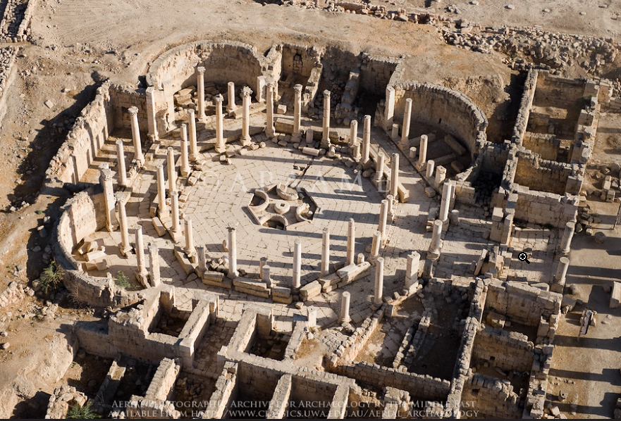 Jarash Macellum
click on image to open in a new tab
Photographer: David Leslie Kennedy
Credit: Aerial Photographic Archive for Archaeology in the Middle East
Copyright: Creative Commons Attribution-Noncommercial-No Derivative Works
- Jerash Macellum in Google Earth
 Jerash Macellum
click on image to explore this site on a new tab in Google Earth
- General Plan of Jerash
from Wikipedia
- Fig. 2 - Plan of Umayyad Jerash
from Walmsley and Daamgaard (2005)

Figure 2
Plan summarising the principal urban features of Umayyad Jarash.
- Umayyad mosque
- possible Islamic administrative centre
- market (suq)
- South Tetrakonia piazza (built over)
- Macellum, with Umayyad–Abbasid rebuilding, and south cardo, encroached by structures;
- Oval piazza domestic quarter with fountain;
- Zeus temple forecourt (kiln, monastery?)
- hippodrome and Bishop Marianos church, eighth century use
- church of SS Peter and Paul and Mortuary Church (Umayyad construction date?)
- churches of SS Cosmas and Damianus, St George and St John theBaptist, with Umayyad–Abbasid occupation and iconoclastic-effected mosaics (later eighth century)
- Christian complex of two churches (Cathedral to the east with stairs from the street, St Theodore’s to the west), mid-5th to late 6th century Bath of Placcus (north of St Theodore’s) and houses west of St Theodore’s with extensive Umayyad occupation including a kiln and oil press
- Artemis compound used for ceramic manufacture
- Synagogue church with iconoclastic-effected mosaics
- North Theatre, also industrialised with kilns
- the 1981 ‘mosque’
- central Cardo with blacksmith’s shop and offices
Map modfied from R.E. Pillen in Zayadine (1986).
Walmsley and Daamgaard (2005)

- Fig. 1 - Plan of the
Macellum
from Uscatescu and Marot (2000)
 Figure 1
Macellum Plan
Uscatescu and Marot (2000) - Fig. 7.1 - Location of the
early Islamic contexts and structures from Uscatescu and Marot (2000)
 Figure 7.1
Location of the early Islamic contexts and structures
Uscatescu and Marot (2000) - Fig. 2.1 - Plan showing location
of mid 7th century CE collapse layer from Uscatescu and Marot (2000)
 Figure 6.1
Location of the mid-seventh century collapse layer.
Uscatescu and Marot (2000)
- Fig. 1 - Plan of the
Macellum
from Uscatescu and Marot (2000)
Figure 1
Macellum Plan
Uscatescu and Marot (2000) - Fig. 7.1 - Location of the
early Islamic contexts and structures from Uscatescu and Marot (2000)
Figure 7.1
Location of the early Islamic contexts and structures
Uscatescu and Marot (2000) - Fig. 2.1 - Plan showing location
of mid 7th century CE collapse layer from Uscatescu and Marot (2000)
Figure 6.1
Location of the mid-seventh century collapse layer.
Uscatescu and Marot (2000)
- Fig. 6.1 - Islamic wall
with mid-7th century collapse layer to the right from Uscatescu and Marot (2000)
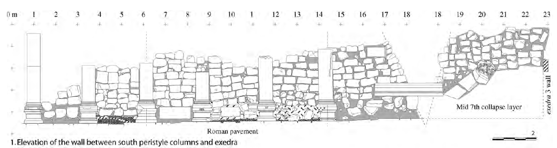 Figure 6.1
Islamic wall between south peristyle columns and exedra 3
JW: Mid 7th century CE collapse layer to right
Uscatescu and Marot (2000)
- Fig. 6.1 - Islamic wall
with mid-7th century collapse layer to the right from Uscatescu and Marot (2000)
Figure 6.1
Islamic wall between south peristyle columns and exedra 3
JW: Mid 7th century CE collapse layer to right
Uscatescu and Marot (2000)
| Effect | Location | Image(s) | Description |
|---|---|---|---|
|
throughout Macellum
Figure 1 Macellum Plan Uscatescu and Marot (2000) |
Figure 6.1 Location of the mid-seventh century collapse layer. Uscatescu and Marot (2000)
Figure 6.1Islamic wall between south peristyle columns and exedra 3 JW: Mid 7th century CE collapse layer to right Uscatescu and Marot (2000) |
|
|
exedra 4
Figure 1 Macellum Plan Uscatescu and Marot (2000) |
|
| Effect | Location | Image(s) | Description |
|---|---|---|---|
|
Islamic galleries over
exedra 4
Figure 1 Macellum Plan Uscatescu and Marot (2000) |
Figure 7.1 Location of the early Islamic contexts and structures Uscatescu and Marot (2000) |
|
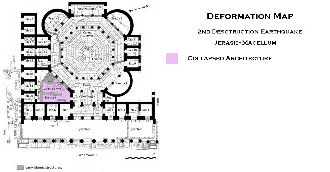
- Modified by JW from Fig.s 1 and 6.1.1 of Uscatescu and Marot (2000)
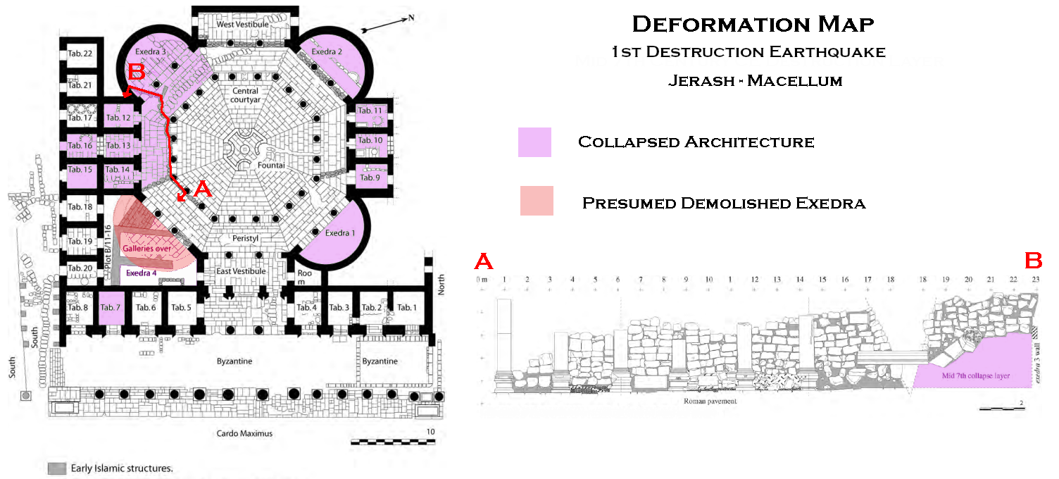 Deformation Map
Click on image to open in a new tab
Modified by JW from Fig.s 1 and 6.1.1 of Uscatescu and Marot (2000)
- Modified by JW from Fig. 1 of Uscatescu and Marot (2000)
 Deformation Map
Click on image to open in a new tab
Modified by JW from Fig. 1 of Uscatescu and Marot (2000)
-
Earthquake Archeological Effects chart
of Rodríguez-Pascua et al (2013: 221-224)
 Earthquake Archeological Effects (EAE)
Rodríguez-Pascua et al (2013: 221-224)
| Effect | Location | Image(s) | Description | Intensity |
|---|---|---|---|---|
|
throughout Macellum
Figure 1 Macellum Plan Uscatescu and Marot (2000) |
Figure 6.1 Location of the mid-seventh century collapse layer. Uscatescu and Marot (2000)
Figure 6.1Islamic wall between south peristyle columns and exedra 3 JW: Mid 7th century CE collapse layer to right Uscatescu and Marot (2000) |
|
|
|
exedra 4
Figure 1 Macellum Plan Uscatescu and Marot (2000) |
|
|
-
Earthquake Archeological Effects chart
of Rodríguez-Pascua et al (2013: 221-224)
Earthquake Archeological Effects (EAE)
Rodríguez-Pascua et al (2013: 221-224)
| Effect | Location | Image(s) | Description | Intensity |
|---|---|---|---|---|
|
Islamic galleries over
exedra 4
Figure 1 Macellum Plan Uscatescu and Marot (2000) |
Figure 7.1 Location of the early Islamic contexts and structures Uscatescu and Marot (2000) |
|
|