Caesarea
 Aerial View of Caesarea
Click on Image for high resolution magnifiable image
Used with permission from Biblewalks.com
| Transliterated Name | Language | Name |
|---|---|---|
| Caesarea | ||
| Caesarea Maritima | ||
| Keysariya | Hebrew | קֵיסָרְיָה |
| Qesarya | Hebrew | קֵיסָרְיָה |
| Qisri | Rabbinic Sources | |
| Qisrin | Rabbinic Sources | |
| Qisarya | Arabic | قيسارية |
| Qaysariyah | Early Islamic Arabic | قايساريياه |
| Caesarea near Sebastos | Greek and Latin sources | |
| Caesarea of Straton | Greek and Latin sources | |
| Caesarea of Palestine | Greek and Latin sources | |
| Caesarea | Ancient Greek | Καισάρεια |
| Straton's Tower | ||
| Strato's Tower | ||
| Stratonos pyrgos | Ancient Greek | |
| Straton's Caesarea |
- Fig. 5 The Caesarea region
from Galili et al (2021)
 Figure 5
The Caesarea region
- Western harbor basin
- Central harbor basin
- Eastern harbor basin
Table 1 [41,43]
Galili et al (2021)
- Fig. 5 The Caesarea region
from Galili et al (2021)
Figure 5
The Caesarea region
- Western harbor basin
- Central harbor basin
- Eastern harbor basin
Table 1 [41,43]
Galili et al (2021)
- Aerial Photo of Caesarea
from 1918 from castellorient.fr
 Aerial Photo of the city of Caesarea taken in 1918 by the German army (the North East on the left)
castellorient.fr - Fig. 5.3 Aerial photograph
of Caesarea showing projected ancient coastline from Raban et al. (2009)
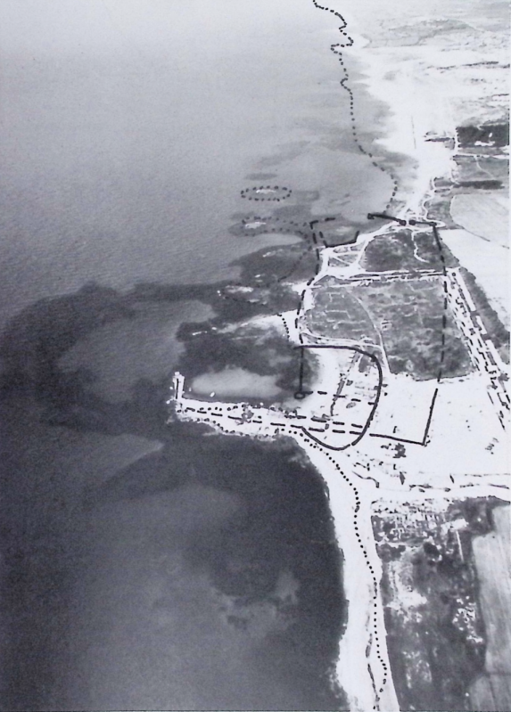 Figure 3.9
Aerial photograph of Caesarea the south. Ancient coastline marked by dotted line, and solid lines mark the two basins of Straton's Tower
(Photograph: A. Blantinschter. Caesarea Project)
Raban et al. (2009) - Fig. 5.71 Aerial view
of Sebastos from the south with the demarcation of the studied areas in the intermediate basin from Raban et al. (2009)
 Figure 5.71
Aerial view of Sebastos from the south with the demarcation of the studied areas in the intermediate basin
(Photograph: A. Raban)
Raban et al. (2009) - Caesarea in Google Earth
 Caesarea
click on image to explore this site on a new tab in Google Earth - Caesarea on govmap.gov.il
 Caesarea
click on image to explore this site on a new tab in govmap.gov.il
- Aerial Photo of Caesarea
from 1918 from castellorient.fr
Aerial Photo of the city of Caesarea taken in 1918 by the German army (the North East on the left)
castellorient.fr - Fig. 5.3 Aerial photograph
of Caesarea showing projected ancient coastline from Raban et al. (2009)
Figure 3.9
Aerial photograph of Caesarea the south. Ancient coastline marked by dotted line, and solid lines mark the two basins of Straton's Tower
(Photograph: A. Blantinschter. Caesarea Project)
Raban et al. (2009) - Fig. 5.71 Aerial view
of Sebastos from the south with the demarcation of the studied areas in the intermediate basin from Raban et al. (2009)
Figure 5.71
Aerial view of Sebastos from the south with the demarcation of the studied areas in the intermediate basin
(Photograph: A. Raban)
Raban et al. (2009) - Caesarea in Google Earth
Caesarea
click on image to explore this site on a new tab in Google Earth - Caesarea on govmap.gov.il
Caesarea
click on image to explore this site on a new tab in govmap.gov.il
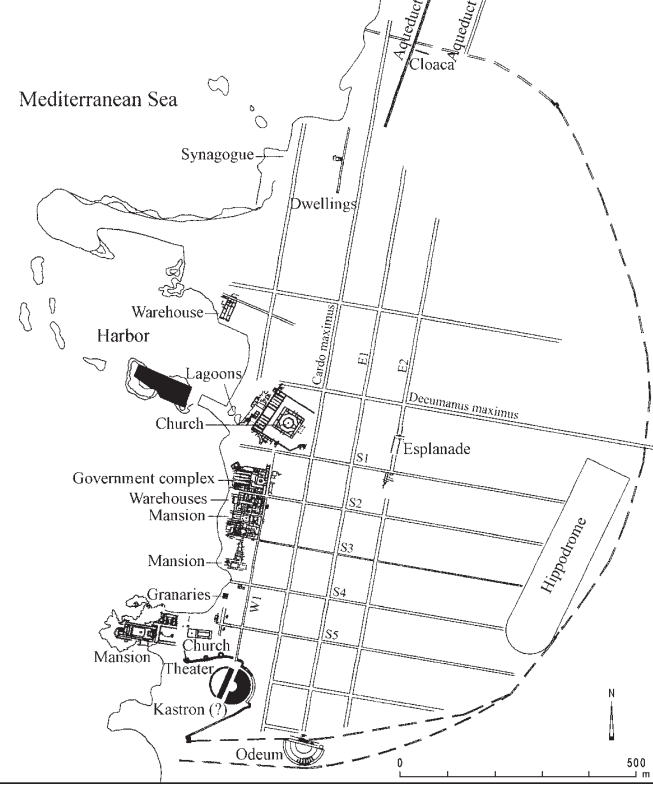
- Fig. 1 Sketch plan of Caesarea
Maritima from Toombs (1978)
 Figure 1
Sketch plan of Caesarea Maritima, showing the location of Fields A, B, C and H in relation to the principal visible monuments on the site.
JW: Area H, not marked on the plan, is the Hippodrome area (Toombs, 1978:229)
Toombs (1978) - Aqueducts in the vicinity of
Caesarea from Stern et. al. (2008)
 Aqueducts of Caesarea
Stern et. al. (2008) - Map of Caesarea showing
excavation areas from Stern et. al. (2008)
 Caesarea: map of the site, showing excavation areas.
BAS - Herodian Caesarea from
Stern et. al. (2008)
 Herodian Caesarea, up to 70 CE.
Stern et. al. (2008) - Byzantine Caesarea from
Stern et. al. (2008)
 Byzantine Caesarea, sixth century CE
Stern et. al. (2008) - Fig. 1 Roman and Crusader
Caesarea from Ad et al (2017)
 Figure 1
Roman and Crusader Caesarea, map of the excavations and the current excavation (sourced from ESI 17:38)..
JW: Excavations were in Areas D and E marked in red on the map
Ad et al (2017) - Fig. 1 Caesarea with principal
sites mentioned by Dey et al(2014)
 Fig. 1
Late antique/early Islamic Caesarea, with principal sites and excavation areas mentioned in the text.
Dey et al(2014) - Fig. 1.9 Plan of early
Islamic Caesarea from Whitcomb (2016)
 Figure 1.9
Plan of early Islamic Qayṣariyya
(after Whitcomb, “Qaysariya as an Early Islamic Settlement”)
Whitcomb (2016) - Fig. 3.5 Site map
of the various excavated areas from Raban et al. (2009)
 Figure 3.5
Site map of the various excavated areas
(Holum, Raban, and Patrich (ed.s) P. S.)
Raban et al. (2009) - Fig. 2.24 Artist's
rendering of view of the central and southern parts of Straton's Tower at the time of Zoilus from Raban et al. (2009)
 Figure 2.24
Artist's rendering of view of the central and southern parts of Straton's Tower at the time of Zoilus
(after Giannetti in Holutn, Hohlfelder. Bull, and Rohan (eds.) 1988. Fig II)
Raban et al. (2009) - Fig. 3.9 General
plan of Herodian structures at Caesarea from Raban et al. (2009)
 Figure 3.9
General plan of Herodian structures at Caesarea
(Raban Caesarea Project)
Raban et al. (2009) - Fig. 2 Map of
the ancient city of Caesarea from Raphael and Bijovsky (2014)
 Figure 2
Map of the ancient city of Caesarea (after Govaars et al. 2009)
Click on image to open in anew tab
Raphael and Bijovsky (2014)
- Fig. 1 Sketch plan of Caesarea
Maritima from Toombs (1978)
Figure 1
Sketch plan of Caesarea Maritima, showing the location of Fields A, B, C and H in relation to the principal visible monuments on the site.
JW: Area H, not marked on the plan, is the Hippodrome area (Toombs, 1978:229)
Toombs (1978) - Aqueducts in the vicinity of
Caesarea from Stern et. al. (2008)
Aqueducts of Caesarea
Stern et. al. (2008) - Map of Caesarea showing
excavation areas from Stern et. al. (2008)
Caesarea: map of the site, showing excavation areas.
BAS - Herodian Caesarea from
Stern et. al. (2008)
Herodian Caesarea, up to 70 CE.
Stern et. al. (2008) - Byzantine Caesarea from
Stern et. al. (2008)
Byzantine Caesarea, sixth century CE
Stern et. al. (2008) - Fig. 1 Roman and Crusader
Caesarea from Ad et al (2017)
Figure 1
Roman and Crusader Caesarea, map of the excavations and the current excavation (sourced from ESI 17:38)..
JW: Excavations were in Areas D and E marked in red on the map
Ad et al (2017) - Fig. 1 Caesarea with principal
sites mentioned by Dey et al(2014)
Fig. 1
Late antique/early Islamic Caesarea, with principal sites and excavation areas mentioned in the text.
Dey et al(2014) - Fig. 1.9 Plan of early
Islamic Caesarea from Whitcomb (2016)
Figure 1.9
Plan of early Islamic Qayṣariyya
(after Whitcomb, “Qaysariya as an Early Islamic Settlement”)
Whitcomb (2016) - Fig. 3.5 Site map
of the various excavated areas from Raban et al. (2009)
Figure 3.5
Site map of the various excavated areas
(Holum, Raban, and Patrich (ed.s) P. S.)
Raban et al. (2009) - Fig. 2.24 Artist's
rendering of view of the central and southern parts of Straton's Tower at the time of Zoilus from Raban et al. (2009)
Figure 2.24
Artist's rendering of view of the central and southern parts of Straton's Tower at the time of Zoilus
(after Giannetti in Holutn, Hohlfelder. Bull, and Rohan (eds.) 1988. Fig II)
Raban et al. (2009) - Fig. 3.9 General
plan of Herodian structures at Caesarea from Raban et al. (2009)
Figure 3.9
General plan of Herodian structures at Caesarea
(Raban Caesarea Project)
Raban et al. (2009) - Fig. 2 Map of
the ancient city of Caesarea from Raphael and Bijovsky (2014)
Figure 2
Map of the ancient city of Caesarea (after Govaars et al. 2009)
Click on image to open in anew tab
Raphael and Bijovsky (2014)
- Fig. 1 Roman and Crusader
Caesarea from Ad et al (2017)
Figure 1
Roman and Crusader Caesarea, map of the excavations and the current excavation (sourced from ESI 17:38)..
JW: Excavations were in Areas D and E marked in red on the map
Ad et al (2017) - Fig. 1 View of ancient
harbor of Caesarea from Reinhardt and Raban (1999)
 Figure 1
View of ancient harbor area showing rubble spill of ancient break-waters, probable configuration of Herod's harbor,
fault lines extending through harbor, and excavation areas.
Reinhardt and Raban (1998) - Fig. 4 The Roman, Herodian
harbor of Caesarea from Galili et al (2021)
 Figure 4
The Roman, Herodian harbor of Caesarea
left panel—aerial photo
right panel—artist reconstruction [43]
- Roman dock
- Roman dock
- submerged surface built of ashlars
- Crusader mole
- Beachrock deposits
Galili et al (2021) - Fig. 2.3 Excavation Areas
in NW part of Caesarea (the harbor) from Raban et al. (2009)
 Figure 2.3
The excavated areas at the NW part of the site
(A. Raban, Caesarea Project)
Raban et al. (2009) - Fig. 2.22 Reconstruction
plan of the the location of the harbour basins of Straton's Tower and the line of the city walls from Raban et al. (2009)
 Figure 2.22
Plan reconstructing the location of the harbour basins of Straton's Tower and the line of the city walls
(Drawing A. Raban)
Raban et al. (2009) - Fig. 2.23 Schematic
map of the inner basin c. 110 BCE from Raban et al. (2009)
 Figure 2.23
Schematic map of the inner basin c. 110 BCE
(Raban 1996b, Fig. 3)
Raban et al. (2009) - Fig. 2.25 General
plan of the excavations at the north side of the intermediate harbour basin from Raban et al. (2009)
 Figure 2.25
General plan of the excavations at the north side of the intermediate harbour basin
(Raban 1996b, Fig.5)
Raban et al. (2009) - Fig. 5.48 Schematic
block diagram of the main mole during phases 2, 3 from Raban et al. (2009)
 Figure 5.48
Schematic block diagram of the main mole during phases 2, 3
(A. Raban. Caesarea Project)
Raban et al. (2009) - Fig. 5.69 Suggested
sketch plan of Sebastos at its final phase of construction from Raban et al. (2009)
 Figure 5.69
A suggested sketch plan of Sebastos at its final phase of construction
(A. Raban. Caesarea Project)
Raban et al. (2009)
- Fig. 1 Roman and Crusader
Caesarea from Ad et al (2017)
Figure 1
Roman and Crusader Caesarea, map of the excavations and the current excavation (sourced from ESI 17:38)..
JW: Excavations were in Areas D and E marked in red on the map
Ad et al (2017) - Fig. 1 View of ancient
harbor of Caesarea from Reinhardt and Raban (1999)
Figure 1
View of ancient harbor area showing rubble spill of ancient break-waters, probable configuration of Herod's harbor,
fault lines extending through harbor, and excavation areas.
Reinhardt and Raban (1998) - Fig. 4 The Roman, Herodian
harbor of Caesarea from Galili et al (2021)
Figure 4
The Roman, Herodian harbor of Caesarea
left panel—aerial photo
right panel—artist reconstruction [43]
- Roman dock
- Roman dock
- submerged surface built of ashlars
- Crusader mole
- Beachrock deposits
Galili et al (2021) - Fig. 2.3 Excavation Areas
in NW part of Caesarea (the harbor) from Raban et al. (2009)
Figure 2.3
The excavated areas at the NW part of the site
(A. Raban, Caesarea Project)
Raban et al. (2009) - Fig. 2.22 Reconstruction
plan of the the location of the harbour basins of Straton's Tower and the line of the city walls from Raban et al. (2009)
Figure 2.22
Plan reconstructing the location of the harbour basins of Straton's Tower and the line of the city walls
(Drawing A. Raban)
Raban et al. (2009) - Fig. 2.23 Schematic
map of the inner basin c. 110 BCE from Raban et al. (2009)
Figure 2.23
Schematic map of the inner basin c. 110 BCE
(Raban 1996b, Fig. 3)
Raban et al. (2009) - Fig. 2.25 General
plan of the excavations at the north side of the intermediate harbour basin from Raban et al. (2009)
Figure 2.25
General plan of the excavations at the north side of the intermediate harbour basin
(Raban 1996b, Fig.5)
Raban et al. (2009) - Fig. 5.48 Schematic
block diagram of the main mole during phases 2, 3 from Raban et al. (2009)
Figure 5.48
Schematic block diagram of the main mole during phases 2, 3
(A. Raban. Caesarea Project)
Raban et al. (2009) - Fig. 5.69 Suggested
sketch plan of Sebastos at its final phase of construction from Raban et al. (2009)
Figure 5.69
A suggested sketch plan of Sebastos at its final phase of construction
(A. Raban. Caesarea Project)
Raban et al. (2009)
- Fig. 1.10 Drawing of
the Temple Platform at Caesarea from Whitcomb (2016)
 Figure 1.10
Comparative views of the Dome of the Rock (above) and the Temple Platform at Caesarea (below)
(after Whitcomb, “Jerusalem and the Beginnings of the Islamic City,” fig. 4 and Holum, “The Temple Platform,” fig. 13)
Whitcomb (2016) - Plan of Area TP containing
the Octagonal Church from Stern et. al. (2008)
 Area TP: plan showing foundations of the octagonal church.
Stern et. al. (2008)
- Fig. 1.10 Drawing of
the Temple Platform at Caesarea from Whitcomb (2016)
Figure 1.10
Comparative views of the Dome of the Rock (above) and the Temple Platform at Caesarea (below)
(after Whitcomb, “Jerusalem and the Beginnings of the Islamic City,” fig. 4 and Holum, “The Temple Platform,” fig. 13)
Whitcomb (2016) - Plan of Area TP containing
the Octagonal Church from Stern et. al. (2008)
Area TP: plan showing foundations of the octagonal church.
Stern et. al. (2008)
- Fig. 2 Plan of the mid-7th
century irrigated garden from Taxel (2013)
 Figure 2
Caesarea-Qaysariyya: general plan of the mid-7th century irrigated garden above the Byzantine structures in the southwestern zone (after J. Patrich, "Caesarea in transition" [supra, n. 69], fig. 12; drawing by Anna Iamim, courtesy Joseph Patrich).
Taxel (2013)
- Fig. 2 Plan of the mid-7th
century irrigated garden from Taxel (2013)
Figure 2
Caesarea-Qaysariyya: general plan of the mid-7th century irrigated garden above the Byzantine structures in the southwestern zone (after J. Patrich, "Caesarea in transition" [supra, n. 69], fig. 12; drawing by Anna Iamim, courtesy Joseph Patrich).
Taxel (2013)
- Fig. 130 Area CV block
plan from Raban et al. (1993 v. II)
 Figure 130
Area CV block plan
William Isenberger drawing
Raban et al. (1993 v. II) - Fig. 129 Aerial View of
Area CV from Raban et al. (1993 v. II)
 Figure 129
Area CV (foreground), looking east across JECM Field C. Vaults 1 and 2 lie beneath remains of U-shaped building and soil deposits in center. At upper left, JECM Areas C.7, C.8, and C.ll with exposed sub-flooring of U-shaped building. Foreground, CV/1 and CV/2 with pavement CV/1047. CV/10 lies to the right (south).
Zaraza Friedman photo.
Raban et al. (1993 v. II)
- Fig. 130 Area CV block
plan from Raban et al. (1993 v. II)
Figure 130
Area CV block plan
William Isenberger drawing
Raban et al. (1993 v. II) - Fig. 129 Aerial View of
Area CV from Raban et al. (1993 v. II)
Figure 129
Area CV (foreground), looking east across JECM Field C. Vaults 1 and 2 lie beneath remains of U-shaped building and soil deposits in center. At upper left, JECM Areas C.7, C.8, and C.ll with exposed sub-flooring of U-shaped building. Foreground, CV/1 and CV/2 with pavement CV/1047. CV/10 lies to the right (south).
Zaraza Friedman photo.
Raban et al. (1993 v. II)
- Fig. 1D Aerial view of
site LL and southern part of the Upper aqueduct from Everhardt et. al. (2023)
 Figure 1D
Aerial view of the archaeological site and southern part of the Upper aqueduct, where reference samples were collected. All colored dots are linked to locations where samples were taken [as references for non tsunamogenic deposits].
Everhardt et. al. (2023) - Fig. 1E Aerial view of
site LL showing locations of cores, baulk, and collapsed corridor from Everhardt et. al. (2023)
 Figure 1E
Aerial view of Area LL, bordering the northern side of the inner harbor basin.
- Blue dots indicate cores collected within the excavation layers
- Green dots mark the southern baulk adjacent to a later crusader wall (after Ad, et. al., 2018)
- Bolded white rectangle in E highlights the Corridor area of Area LL, the primary focus of the study
Everhardt et. al. (2023) - Fig. 3 Early phases Plan
of Area LL from Ad et al (2018)
 Figure 3
Plan
Ad et al (2018) - Fig. 8 Wall Collapse in
Stratum VI (Umayyad) from Ad et al (2018)
 Figure 8
Wall Collapse looking west
Ad et al (2018) - Fig. 3 Sections of Cores
C1 and C2 and the Southern Baulk from Everhardt et. al. (2023)
 Figure 3
Cores C1 and C2 (left) and Southern Baulk section (right)
Everhardt et. al. (2023) - Fig. 2B Destruction
layer(s) showing building stones suspended in anomalous sands from Everhardt et. al. (2023)
 Figure 2B
Anomalous layer (the top of which touched the Abbasid floor above)
Everhardt et. al. (2023) - Fig. 2C Archaeological
fill directly underlying anomalous deposit along with inset of fire-burnt stones from Everhardt et. al. (2023)
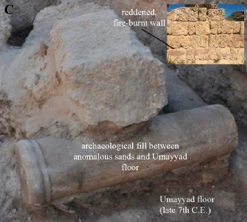 Figure 2C
Umayyad archaeological fill directly underlying the anomalous deposit. Inset shows fire-burnt stones in the eastern wall of the corridor, at the same level as the top of the Umayyad archaeological fill.
Everhardt et. al. (2023) - Fig. 4 Lab Analysis of
Core C1 from Everhardt et. al. (2023)

Figure 4
Core LL16 C1 results.
- Grain size distribution with depth in the core (1 cm sampling resolution) presented as a contour map as well as in conventional profiles (mean, mode, standard deviation)
- TOC [Total Organic Carbon] and IC [Inorganic Carbon] values (%) of a representative set of samples are shown as a profile for Core C1, reference samples are shown in squares (TOC) and triangles (IC) to show their comparative values to the core (yellow = aqueduct beach sand ramp; aquamarine = shallow marine (−5 m depth), see Figure 1 for specific locations).
- Total and pristine foraminiferal abundances are shown plotted by core depth, sampling resolution of 5 cm.
- B-OSL signals (photon-counts) are plotted by depth with a resolution of about 3–5 cm in units A and B, and 10 cm in Unit C.
- The far right core illustration provides the thickness of each unit to scale, and the colors of the data points correspond with visually recognizable units.
Everhardt et. al. (2023) - Fig. 5 Lab Analysis of
Southern Baulk from Everhardt et. al. (2023)
 Figure 5
'LL Southern Baulk’ Results.
- ODV [Ocean Data View] graph (far left) showing grain size distribution and grain sorting with depth in the LL Southern Baulk Section (19 samples)
- grain size statistics
- total and pristine foraminiferal abundances with depth for several samples taken from each unit
- section illustration with the thicknesses of each unit. Light green data points correspond to the upper ‘LL Southern Baulk’ section samples, while the dark green points correspond to the lower ‘LL Southern Baulk’ section samples
Everhardt et. al. (2023) - Fig. 8 Projected direction
of tsunami surge from Everhardt et. al. (2023)
 Figure 8
Tsunami corridor. Based on the damage to the southern and southwestern walls and orientation of the collapsed building stones, the dominant destruction came from the southern harbor facing side of the corridor.
Everhardt et. al. (2023)
- Fig. 1D Aerial view of
site LL and southern part of the Upper aqueduct from Everhardt et. al. (2023)
Figure 1D
Aerial view of the archaeological site and southern part of the Upper aqueduct, where reference samples were collected. All colored dots are linked to locations where samples were taken [as references for non tsunamogenic deposits].
Everhardt et. al. (2023) - Fig. 1E Aerial view of
site LL showing locations of cores, baulk, and collapsed corridor from Everhardt et. al. (2023)
Figure 1E
Aerial view of Area LL, bordering the northern side of the inner harbor basin.
- Blue dots indicate cores collected within the excavation layers
- Green dots mark the southern baulk adjacent to a later crusader wall (after Ad, et. al., 2018)
- Bolded white rectangle in E highlights the Corridor area of Area LL, the primary focus of the study
Everhardt et. al. (2023) - Fig. 3 Early phases Plan
of Area LL from Ad et al (2018)
Figure 3
Plan
Ad et al (2018) - Fig. 8 Wall Collapse in
Stratum VI (Umayyad) from Ad et al (2018)
Figure 8
Wall Collapse looking west
Ad et al (2018) - Fig. 3 Sections of Cores
C1 and C2 and the Southern Baulk from Everhardt et. al. (2023)
Figure 3
Cores C1 and C2 (left) and Southern Baulk section (right)
Everhardt et. al. (2023)
- Fig. 3 Plan of
the Stratum IV synagogue from Raphael and Bijovsky (2014)
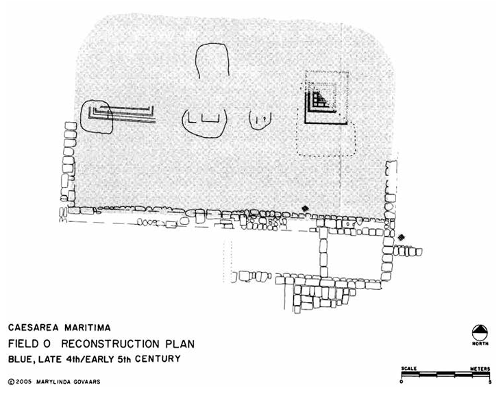 Figure 3
Plan of the synagogue, Stratum IV
(Govaars et al. 2009; after original plan in Dunayevsky 1962)
Click on image to open in anew tab
Raphael and Bijovsky (2014)
- Fig. 3 Plan of
the Stratum IV synagogue from Raphael and Bijovsky (2014)
Figure 3
Plan of the synagogue, Stratum IV
(Govaars et al. 2009; after original plan in Dunayevsky 1962)
Click on image to open in anew tab
Raphael and Bijovsky (2014)
- Fig. 2 Satellite image
showing locations of Caesarea Cores 1, 2, and 5, Area W, and shot points of the 2011 CHIRP survey from Goodman-Tchernov and Austin (2015)
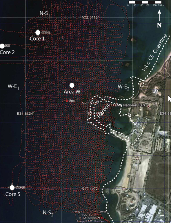 Figure 2
CHIRP profiles (red dashed lines), collected offshore of Caesarea in August 2011. Total track length was ~126 km, and profile spacing was ~5 m. Each dip profile is ~0.65 km long, while each strike profile is ~1.4 km long. Note locations of cores/seafloor excavations (red square, white dots), within which tsunamites were interpreted (Goodman-Tchernov et al., 2009). Remains of the ancient Roman city lie to the east; part of the ancient harbor still exists, defined by the remains of semi-circular moles/groins visible just below “Caesarea National Park” in this satellite image. The approximate outline of the original harbor is shown (white dashed lines). White arrowheads denote the locations of the strike and dip profiles shown in Fig. 3.
Click on image to open in a new tab
Goodman-Tchernov and Austin (2015)
- Fig. 2 Satellite image
showing locations of Caesarea Cores 1, 2, and 5, Area W, and shot points of the 2011 CHIRP survey from Goodman-Tchernov and Austin (2015)
Figure 2
CHIRP profiles (red dashed lines), collected offshore of Caesarea in August 2011. Total track length was ~126 km, and profile spacing was ~5 m. Each dip profile is ~0.65 km long, while each strike profile is ~1.4 km long. Note locations of cores/seafloor excavations (red square, white dots), within which tsunamites were interpreted (Goodman-Tchernov et al., 2009). Remains of the ancient Roman city lie to the east; part of the ancient harbor still exists, defined by the remains of semi-circular moles/groins visible just below “Caesarea National Park” in this satellite image. The approximate outline of the original harbor is shown (white dashed lines). White arrowheads denote the locations of the strike and dip profiles shown in Fig. 3.
Click on image to open in a new tab
Goodman-Tchernov and Austin (2015)
- Fig. 132 South Balk of
Area CV/1 showing five phases from Raban et al. (1993 v. II)
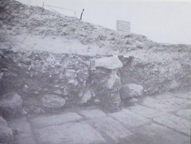 Figure 132
Area CV/1, south balk. Five phases are visible:
- pavers 1047 from ca. 575 C.E.
- structural debris above pavers from mid-7th century collapse
- light brown dune sand above collapse due to long period of abandonment (mid-7th to 10th century C.E.?)
- patch of dark soil above and left representing western end of Islamic industrial installation (10th-12th centuries C.E.) that penetrated the dune sand
- upper layers across photograph were dump from 1973/74 excavations
Lisa Helfert photo.
Raban et al. (1993 v. II) - Fig. 133 Structural collapse
and crushed pottery in Area CV/2 from Raban et al. (1993 v. II)
 Figure 133
Area CV/2, structural collapse from Vault 2, looking west. Ceramics crushed by falling masonry (L2017)
Lisa Helfert photo
Raban et al. (1993 v. II) - Fig. 1 Avi-Yonah at
the spot of discovery of the hoard from Raphael and Bijovsky (2014)
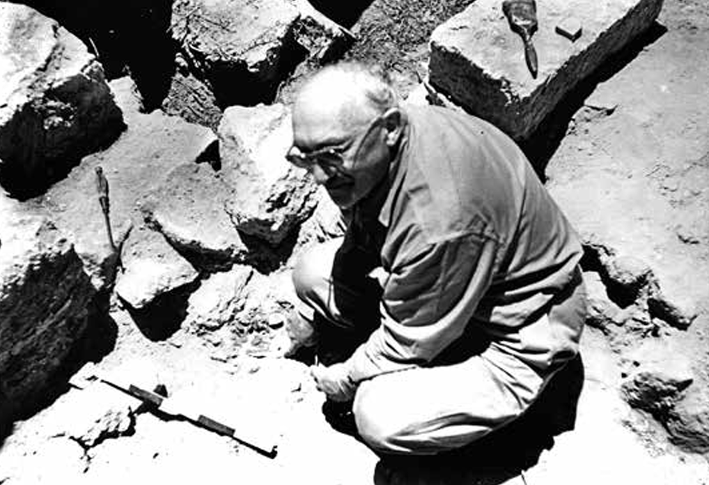 Figure 1
Avi-Yonah at the spot of discovery of the hoard
(courtesy of the E. Jerry Vardaman Estate and Marylinda Govaars)
Click on image to open in anew tab
Raphael and Bijovsky (2014) - Fig. 4 Excavation of
the Field O synagogue from Raphael and Bijovsky (2014)
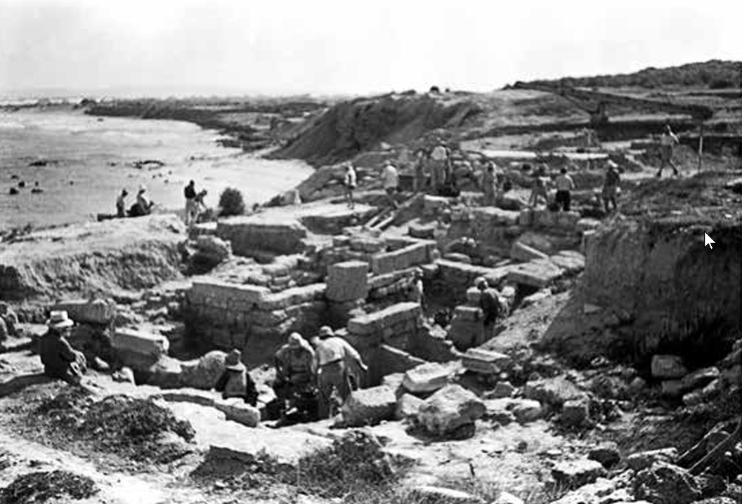 Figure 4
View from the northeast to the excavation at the synagogue
(courtesy of the E. Jerry Vardaman Estate and Marylinda Govaars)
Click on image to open in a new tab
Raphael and Bijovsky (2014)
- Fig. 132 South Balk of
Area CV/1 showing five phases from Raban et al. (1993 v. II)
Figure 132
Area CV/1, south balk. Five phases are visible:
- pavers 1047 from ca. 575 C.E.
- structural debris above pavers from mid-7th century collapse
- light brown dune sand above collapse due to long period of abandonment (mid-7th to 10th century C.E.?)
- patch of dark soil above and left representing western end of Islamic industrial installation (10th-12th centuries C.E.) that penetrated the dune sand
- upper layers across photograph were dump from 1973/74 excavations
Lisa Helfert photo.
Raban et al. (1993 v. II) - Fig. 133 Structural collapse
and crushed pottery in Area CV/2 from Raban et al. (1993 v. II)
Figure 133
Area CV/2, structural collapse from Vault 2, looking west. Ceramics crushed by falling masonry (L2017)
Lisa Helfert photo
Raban et al. (1993 v. II) - Fig. 1 Avi-Yonah at
the spot of discovery of the hoard from Raphael and Bijovsky (2014)
Figure 1
Avi-Yonah at the spot of discovery of the hoard
(courtesy of the E. Jerry Vardaman Estate and Marylinda Govaars)
Click on image to open in anew tab
Raphael and Bijovsky (2014) - Fig. 4 Excavation of
the Field O synagogue from Raphael and Bijovsky (2014)
Figure 4
View from the northeast to the excavation at the synagogue
(courtesy of the E. Jerry Vardaman Estate and Marylinda Govaars)
Click on image to open in a new tab
Raphael and Bijovsky (2014)
 Stratigraphy/Chronology - Inner Harbor Areas I/1 - Z/2
Raban et al. (1989 Vol. 1)
 Stratigraphy of Areas CC, KK, and NN
Stern et. al. (2008)
 Phases of the Starting Gates of the Hippodrome
Stern et. al. (2008)
- Toombs (1978) developed a stratigraphic framework for Caesarea after 4 seasons of excavations using the destruction layers overlying the latest Byzantine occupation as the stratigraphic key. The framework was developed primarily on balk sections from four fields - A, B, C, and H. It is considered most accurate for the Byzantine and Arab phases and least accurate for Late Arab and Roman levels.
- Dates with an asterisk (*) were derived from Note 4 in Toombs (1978:232)
- Sketch plan of Caesarea Maritima from Toombs (1978)
.
Figure 1
Sketch plan of Caesarea Maritima, showing the location of Fields A, B, C and H in relation to the principal visible monuments on the site.
JW: Area H, not marked on the plan, is the Hippodrome area (Toombs, 1978:229)
Toombs (1978)
| Phase | Period | Date | Comments |
|---|---|---|---|
| I | Modern | ||
| II | Crusader | 1200-1300 CE | |
| III.1 | Late Arab | 900*-1200 CE | |
| III.2 | Middle Arab Abbasid |
750-900* CE | |
| III.3 | Early Arab Umayyad |
640-750 CE | |
| IV | Byzantine/Arab | 640 CE | In A.D. 640 Caesarea fell to Arab invaders. This time the destruction was complete and irretrievable. Battered columns and the empty shells of buildings stood nakedly above heaps of tangled debris. |
| V | Final Byzantine | 614-640 CE | In A.D. 614 Persian armies captured Caesarea, but withdrew by A.D. 629. This invasion caused widespread destruction and brought the Main Byzantine Period to a close, but recovery was rapid and the city was restored |
| VI.1 | Main Byzantine | 450/550*-614 CE | |
| VI.2 | Main Byzantine | 330 - 450/550* CE | |
| VII.1 | Roman | 200*-330 CE | It seems probable that during the Late Roman Period a major catastrophe befell the city, causing a partial collapse of the vaulted warehouses along the waterfront, and the destruction of major buildings within the city. Such a city-wide disaster alone would account for the rebuilding of the warehouse vaulting and the buildings above it, as well as the virtual absence of intact Roman structures in the city proper. |
| VII.2 | Roman | 100*-200* CE | |
| VII.3 | Roman | 10 BCE - 100* CE |
- Toombs (1978) developed a stratigraphic framework for Caesarea after 4 seasons of excavations using the destruction layers overlying the latest Byzantine occupation as the stratigraphic key. The framework was developed primarily on balk sections from four fields - A, B, C, and H. It is considered most accurate for the Byzantine and Arab phases and least accurate for Late Arab and Roman levels.
- Sketch plan of Caesarea Maritima from Toombs (1978)
.
Figure 1
Sketch plan of Caesarea Maritima, showing the location of Fields A, B, C and H in relation to the principal visible monuments on the site.
JW: Area H, not marked on the plan, is the Hippodrome area (Toombs, 1978:229)
Toombs (1978)
 Figure 4
Stratigraphic analysis of the results of the first four seasons at Caesarea, tabulated by Field.
Toombs (1978)
 Table 1
Earthquakes or tsunamis noted on the coast of Israel
Click on Image to open in a new tab
Raphael and Bijovsky (2014)
- Fig. 6 - Seismic Reflectors
and evolution of Caesarea's harbor from Goodman-Tchernov and Austin (2015)
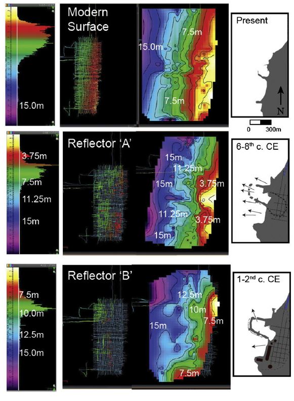
Fig. 6
Structure maps of- the modern seafloor (top)
- reflector “A” (middle)
- reflector “B” (bottom)
Goodman-Tchernov and Austin (2015)
- Fig. 6 - Seismic Reflectors
and evolution of Caesarea's harbor from Goodman-Tchernov and Austin (2015)
Fig. 6
Structure maps of- the modern seafloor (top)
- reflector “A” (middle)
- reflector “B” (bottom)
Goodman-Tchernov and Austin (2015)
Goodman-Tchenov and Austin (2015) mapped the tsunami horizons from a high frequency seismic reflection survey (2.5-5.5 kHz. Chirp source) which produced markers ~4-5 meters below the sea floor before sea bottom multiples obscured the image. Shot spacing was ~ 5 meters. The fold of the survey is not reported. It may have been single fold. Velocity control below the seafloor is also unreported. The time-depth conversion in Figure 6 above may have been based on correlating seismic markers to core horizons. Reflector 'A' was correlated to the 5th-8th century tsunami deposit. Reflector 'B' was correlated to a 1st-2nd century CE tsunami deposit which they associate with the 115 CE Trajan Quake although I think it more likely correlates to localized shelf collapse due to the the early 2nd century CE Incense Road Quake or an unknown event. Structure maps constructed from time horizons of Reflectors A and B show the apparent presence of backflow channels from both tsunami events with 3-6 channels associated with the 5th - 8th century CE horizon and 1-2 channels associated with the 1st-2nd century CE horizon. The presence of more identifiable backflow channels on Reflector A (5th - 8th century CE) than Reflector B (1st - 2nd century CE) was interpreted to be a result of harbor degradation by Byzantine-Islamic time resulting in less flow impediments from man-made structures. This appears to be supported by archeological evidence which showed more ships anchoring at sea during this time.
- Fig. 1- View of ancient
harbor of Caesarea from Reinhardt and Raban (1999)
Figure 1
View of ancient harbor area showing rubble spill of ancient break-waters, probable configuration of Herod's harbor,
fault lines extending through harbor, and excavation areas.
JW: Area K is top left
Reinhardt and Raban (1998) - Fig. 2 - Stratigraphic
Sections from Reinhardt and Raban (1999)
 Figure 2
Stratigraphic sections from excavation areas from intermediate and inner harbor (see Fig. 1 for locations). For biofacies characters and 87Sr/86Sr data, see Table 1. Stratigraphic, foraminiferal, and 87Sr/86Sr data from TN1a, I14, and I9 were reported by Reinhardt et al. (1998a), Yule and Barham (1999a, 1999b), and Raban et al. (1999b). 14C samples were measured at Weizmann Institute of Science, Israel (sample numbers RT2585, RT2631, and RT2650-RT2654) and calibrated to calendar ages using method of Stuiver and Reimer (1993).
Reinhardt and Raban (1998) - Fig. 3 - Possible harbor
configurations through time from Reinhardt and Raban (1999)
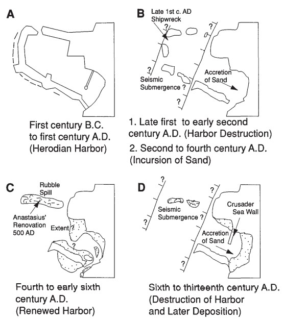 Figure 3
Figure 3. A–D: Possible harbor configurations through time based on stratigraphy from intermediate and inner harbor. C is also based upon earlier archaeological excavations from within inner harbor described by Raban (1996).
Reinhardt and Raban (1998) - Fig. 2 - Herodian-phase mole
demonstrating ~2000 years of a stable sea level from Dey et al(2014)
 Fig. 2
The harbor mole today at low tide. Dotted line highlights the Herodian-phase mole, indicating little difference in sea level relative to today.
Dey et al(2014)
- Caesarea with principal
sites mentioned by Dey et al(2014)
Fig. 1
Late antique/early Islamic Caesarea, with principal sites and excavation areas mentioned in the text.
Dey et al(2014)
- Caesarea with principal
sites mentioned by Dey et al(2014)
Fig. 1
Late antique/early Islamic Caesarea, with principal sites and excavation areas mentioned in the text.
Dey et al(2014)
Dey et al (2014) report that evidence for seismic destruction due to one of the mid 8th century earthquakes is present adjacent to the Temple Platform and possibly at the octagonal church.
At Caesarea, the best evidence of destruction attributable to the 749 earthquake comes from Area TPS, on the S side of the Temple Platform, where a thick layer of debris marks the end of the Umayyad occupation of the Late Byzantine bath complex, which was subsequently mulled and built over in the later 8th century - see Raban and Yankelevitz (2008:81) and Arnon (2008:85). Another probable effect of the earthquake was the collapse of the octagonal church on the platform - see Holum et al (2008:30-31).
- Caesarea with principal
sites mentioned by Dey et al(2014)
Fig. 1
Late antique/early Islamic Caesarea, with principal sites and excavation areas mentioned in the text.
Dey et al(2014)
- Caesarea with principal
sites mentioned by Dey et al(2014)
Fig. 1
Late antique/early Islamic Caesarea, with principal sites and excavation areas mentioned in the text.
Dey et al(2014)
In addition, there appears to be evidence of landward tsunami deposits. After the Muslim conquest in the 7th century, Caesarea depopulated. In the late 7th or early 8th century CE, the coastal strip south of where the Crusaders would later build their fortifications was transformed into
lush terraced gardensirrigated by wells and cisterns ( Dey et al, 2014). Marine layers found on top of these gardens included Glycymeris, a non-edible deeper water bivalve. Atop the marine layer was, in some areas, a burial ground with a funerary inscription providing a terminus ante quem of 870 CE. A terminus post quem of c. 500 came from a
reflecting poolfronting the Temple platform and overlain by the marine layer. Dey et al (2014) suggest that the most likely explanation for the transformation from gardens to burial ground was an intervening episode of tsunamogenic destruction. They discussed the potential landward tsunamogenic deposit as follows:
The most substantial strata attributable to a marine inundation of mid-8th-c. date appeared in the SW sector, along the coastal strip south of the Crusader fortifications. Extensive tracts of these deposits between the temple platform and the theater, a shore-parallel distance of nearly 800 m, were uncovered (and removed, usually mechanically) in the 1970s and early 1980s under the auspices of the Joint Expedition (JECM). The bulk of the deposits lay in a shallow depression situated c.10 m above mean sea-level (MSL) and separated from the sea by a low ridge 15 m above MSL. From the landward side of the ridge, beginning c.50 m from the shore, these marine layers stretched inland as far as 300 m from the sea. 14 They comprised two distinct, superimposed sequences, each consisting of a thick, lower layer of densely-bedded (and in some cases imbricated) shells, rubble and sherds up to 1.5 m thick, topped by a dark, silty layer 20-40 cm thick. Datable materials in the second, upper sequence placed its formation around the 14th c. 15 In the lower sequence, dated by the excavators approximately to the 8th c. on the basis of finds, numerous disarticulated human remains turned up, as well as at least one complete skeleton in Area C, interbedded with the surrounding strata of shells and silt. 16 Like the rest of the materials, this corpse was probably deposited by a (cataclysmic) natural event. As D. Neev and K. Emery indicated in their report, there were no signs of a man-made grave, and the surrounding horizontal strata were uninterrupted above and below the skeleton; such 'culturally non-appropriate burials' are now recognized as a typical feature of tsunami deposits.17 The most likely scenario would have corpses deposited by the retreating waters of the tsunami and immediately covered with more detritus, keeping the articulated skeleton undisturbed by scavenging animals or human intervention.
- Fig. 1D Aerial view of
site LL and southern part of the Upper aqueduct from Everhardt et. al. (2023)
Figure 1D
Aerial view of the archaeological site and southern part of the Upper aqueduct, where reference samples were collected. All colored dots are linked to locations where samples were taken [as references for non tsunamogenic deposits].
Everhardt et. al. (2023) - Fig. 1E Aerial view of
site LL showing locations of cores, baulk, and collapsed corridor from Everhardt et. al. (2023)
Figure 1E
Aerial view of Area LL, bordering the northern side of the inner harbor basin.
- Blue dots indicate cores collected within the excavation layers
- Green dots mark the southern baulk adjacent to a later crusader wall (after Ad, et. al., 2018)
- Bolded white rectangle in E highlights the Corridor area of Area LL, the primary focus of the study
Everhardt et. al. (2023) - Fig. 3 Early phases Plan
of Area LL from Ad et al (2018)
Figure 3
Plan
Ad et al (2018) - Fig. 8 Wall Collapse in
Stratum VI (Umayyad) from Ad et al (2018)
Figure 8
Wall Collapse looking west
Ad et al (2018) - Fig. 3 Sections of Cores
C1 and C2 and the Southern Baulk from Everhardt et. al. (2023)
Figure 3
Cores C1 and C2 (left) and Southern Baulk section (right)
Everhardt et. al. (2023) - Fig. 2B Destruction
layer(s) showing building stones suspended in anomalous sands from Everhardt et. al. (2023)
Figure 2B
Anomalous layer (the top of which touched the Abbasid floor above)
Everhardt et. al. (2023) - Fig. 2C Archaeological
fill directly underlying anomalous deposit along with inset of fire-burnt stones from Everhardt et. al. (2023)
Figure 2C
Umayyad archaeological fill directly underlying the anomalous deposit. Inset shows fire-burnt stones in the eastern wall of the corridor, at the same level as the top of the Umayyad archaeological fill.
Everhardt et. al. (2023) - Fig. 4 Lab Analysis of
Core C1 from Everhardt et. al. (2023)
Figure 4
Core LL16 C1 results.
- Grain size distribution with depth in the core (1 cm sampling resolution) presented as a contour map as well as in conventional profiles (mean, mode, standard deviation)
- TOC [Total Organic Carbon] and IC [Inorganic Carbon] values (%) of a representative set of samples are shown as a profile for Core C1, reference samples are shown in squares (TOC) and triangles (IC) to show their comparative values to the core (yellow = aqueduct beach sand ramp; aquamarine = shallow marine (−5 m depth), see Figure 1 for specific locations).
- Total and pristine foraminiferal abundances are shown plotted by core depth, sampling resolution of 5 cm.
- B-OSL signals (photon-counts) are plotted by depth with a resolution of about 3–5 cm in units A and B, and 10 cm in Unit C.
- The far right core illustration provides the thickness of each unit to scale, and the colors of the data points correspond with visually recognizable units.
Everhardt et. al. (2023) - Fig. 5 Lab Analysis of
Southern Baulk from Everhardt et. al. (2023)
Figure 5
'LL Southern Baulk’ Results.
- ODV [Ocean Data View] graph (far left) showing grain size distribution and grain sorting with depth in the LL Southern Baulk Section (19 samples)
- grain size statistics
- total and pristine foraminiferal abundances with depth for several samples taken from each unit
- section illustration with the thicknesses of each unit. Light green data points correspond to the upper ‘LL Southern Baulk’ section samples, while the dark green points correspond to the lower ‘LL Southern Baulk’ section samples
Everhardt et. al. (2023) - Fig. 8 Projected direction
of tsunami surge from Everhardt et. al. (2023)
Figure 8
Tsunami corridor. Based on the damage to the southern and southwestern walls and orientation of the collapsed building stones, the dominant destruction came from the southern harbor facing side of the corridor.
Everhardt et. al. (2023)
- Fig. 1D Aerial view of
site LL and southern part of the Upper aqueduct from Everhardt et. al. (2023)
Figure 1D
Aerial view of the archaeological site and southern part of the Upper aqueduct, where reference samples were collected. All colored dots are linked to locations where samples were taken [as references for non tsunamogenic deposits].
Everhardt et. al. (2023) - Fig. 1E Aerial view of
site LL showing locations of cores, baulk, and collapsed corridor from Everhardt et. al. (2023)
Figure 1E
Aerial view of Area LL, bordering the northern side of the inner harbor basin.
- Blue dots indicate cores collected within the excavation layers
- Green dots mark the southern baulk adjacent to a later crusader wall (after Ad, et. al., 2018)
- Bolded white rectangle in E highlights the Corridor area of Area LL, the primary focus of the study
Everhardt et. al. (2023) - Fig. 3 Early phases Plan
of Area LL from Ad et al (2018)
Figure 3
Plan
Ad et al (2018) - Fig. 8 Wall Collapse in
Stratum VI (Umayyad) from Ad et al (2018)
Figure 8
Wall Collapse looking west
Ad et al (2018) - Fig. 3 Sections of Cores
C1 and C2 and the Southern Baulk from Everhardt et. al. (2023)
Figure 3
Cores C1 and C2 (left) and Southern Baulk section (right)
Everhardt et. al. (2023)
Site LL is located just north of Caesarea's inner harbour. Ad et al (2018) excavated the site
which was in use from the Herodian period to the Umayyad period. A storage structure (aka "the warehouse") was identified in the western part of the site which appears to have been constructed in Herodian times and remained in use, as it underwent changes, until the middle of the Umayyad period (~700 CE). After the Islamic conquest of Caesarea (640 CE),
rooms were partitioned, floors were raised, construction was added and some of the openings were sealed.Ceramics indicate that the site was abandoned at the end of the 7th century CE after which it suffered two major destruction events before re-occupation occurred in the mid 8th century CE in what was interpreted as Abbasid Strata V (the Abbasid Caliphate began ruling in 750 CE). During the renewed Abbasid occupation, destruction debris were preserved
as the builders preferred to level the area and build above the destruction layer(s).The destruction events within Stratum VI (Umayyad) appear to be an earthquake and a tsunami; both likely a result of the the Holy Desert Quake of the Sabbatical Year Quake sequence.
Ad et al (2018) report that during the earthquake event
several ceilings collapsed inward, and there was evidence of a fire in the eastern warehouse.1 In the collapse in the corridor, the
original order of the courses of the wall or vault could be clearly identified (Fig. 8)adding confidence to a seismic interpretation. During the subsequent tsunami event,
a layer of sand and collapsed building stones had accumulated to a height of more than 2 m in Rooms 8–11 in the western warehouse and to a height of 1.5 m in Rooms 12–14 and the corridor of the eastern warehouse.Everhardt et. al. (2023) further examined the destruction deposits by taking cores and radiocarbon samples as well as examining burn evidence and a baulk inside the collapsed corridor.
The cores (C1 and C2) were taken in the collapsed corridor after the Abbasid floor was removed, thus sampling the destruction deposits. See Fig. 1E for location of the cores (and southern baulk) and Fig. 3 for photos and descriptions of the cores and the southern baulk. A ~20 mg. charcoal sample
from the top 3 cm of sediment in the Umayyad archaeological fill and one untreated sample of various organic material (~20 mg) from the top 5 cm of the same layer in core C1, as close as possible to the contact with the lower anomalous deposit, were collected for radiocarbon dating.Everhardt et. al. (2023:14-15) report that
radiocarbon dates of charcoal and organic material from the upper contact of the Umayyad archaeological deposit (Unit C) range from 605 to 779 CE2 which is in agreement with the phasing of Ad et al (2018) and compatible with destruction layers that were deposited in 749 CE.
Cores C1 and C2 were sampled and analyzed for grain size distribution, foraminiferal assemblage, total organic carbon (TOC), and Inorganic Carbon (IC). An additional 13 surface surface samples, including from storm surge deposits, were also collected, analyzed, and compared with the analysis of the Cores and Southern Baulk in order to help distinguish if a tsunami deposit was indicated in the cores and baulk. Portable-Optically Stimulated Luminescence (P-OSL) dating was also performed on the cores. Four sedimentary units (A-D) were identified in the two cores are were described as follows :
| Unit | Alias | Description | Interpretation |
|---|---|---|---|
| A | ‘anomalous’ deposit | clean, loose quartz sand with no sedimentary structures or cultural artifacts. |
tsunami deposit |
| B | same sediment as Unit A but with additions of several marine-encrusted potsherds and reddened, partially heat-fused sand clusters. |
earthquake and fire debris mixed with a tsunami deposit | |
| C | 'Umayyad archaeological fill' | a dark gray/brown (10YR 6/2), organic-rich layer with many cultural artifacts, including potsherds, glass shards, shells, beach pebbles, charcoal, and bone fragments. |
Post abandonment deposition from the latter half of the Umayyad period - typical of an ancient garbage dump |
| D | compact earthen floor |
Umayyad or earlier floor |
reddened, partially heat-fused sand clusterswere
in agreement with the presence of reddened in-situ building blocks along the intact eastern wall of the room (and elsewhere along the walls)which indicated that a fire took place before the tsunami struck. They also noted an
abundance of charcoal found in the upper Umayyad archaeological fill.They viewed the presence of marine-encrusted potsherds as an indicator that
these inclusions were previously submerged in the marine system long enough for the encrustation to take place, suggesting that they were transported from the sea to land at the time of the eventwhich in turn could
indicate that the tsunami water and deposits extinguishedthe fire.
Everhardt et. al. (2023) proposed that the lower southern baulk was also a tsunamogenic deposit related to 'anomalous" deposit Unit A in the cores.
| Effect | Location | Image(s) | Description |
|---|---|---|---|
| Liquefaction and Subsidence | outer harbor breakwater
Figure 4 The Roman, Herodian harbor of Caesarea left panel—aerial photo right panel—artist reconstruction [43]
Galili et al (2021)  Fig. 1
Caesarea harbor, overview (adapted from Boyce et al 2009) Dey and Goodman-Tchernov (2010)
Figure 1View of ancient harbor area showing rubble spill of ancient break-waters, probable configuration of Herod's harbor, fault lines extending through harbor, and excavation areas. JW: Area K is top left Reinhardt and Raban (1998) |
Figure 2 Stratigraphic sections from excavation areas from intermediate and inner harbor (see Fig. 1 for locations). For biofacies characters and 87Sr/86Sr data, see Table 1. Stratigraphic, foraminiferal, and 87Sr/86Sr data from TN1a, I14, and I9 were reported by Reinhardt et al. (1998a), Yule and Barham (1999a, 1999b), and Raban et al. (1999b). 14C samples were measured at Weizmann Institute of Science, Israel (sample numbers RT2585, RT2631, and RT2650-RT2654) and calibrated to calendar ages using method of Stuiver and Reimer (1993). Reinhardt and Raban (1998)
Figure 3Figure 3. A–D: Possible harbor configurations through time based on stratigraphy from intermediate and inner harbor. C is also based upon earlier archaeological excavations from within inner harbor described by Raban (1996). Reinhardt and Raban (1998) |
|
| Tsunami | Offshore Caesarea
Fig. 1 Caesarea harbor, overview (adapted from Boyce et al 2009) Dey and Goodman-Tchernov (2010)  Fig. 3
Location of sediment cores extracted in 2005 and 2007 Dey and Goodman-Tchernov (2010) |
 Fig. 4
Dip and strike CHIRP profiles (see Fig. 3), from which sample segments “a” and “b” have been enlarged for comparison with previously identified sediment core and underwater excavation stratigraphic compilations within the surveyed area (Reinhardt et al., 2006; Reinhardt and Raban, 2008; Goodman-Tchernov et al., 2009). Three horizons, representing four tsunami events, are recognizable from the available core evidence within the surveyed area (for core locations, see Fig. 1C). Goodman-Tchernov and Austin (2015)  Fig. 4
Summary of tsunamigenic characteristics identified in cores and excavations from the shore ('NS') and terrestrial area (`T') to greater depths JW: Later publications redated Byzantine 551 A.D. to 749 .A.D. with possible reworked 551 A.D. deposits. If Roman 115 A.D. deposit is tsunamogenic, it was more likely caused by the early 2nd century Incense Road Earthquake rather than the distant 115 A.D. Trajan Quake Dey and Goodman-Tchernov (2010) |
|
| Tsunami | Harbor
Figure 4 The Roman, Herodian harbor of Caesarea left panel—aerial photo right panel—artist reconstruction [43]
Galili et al (2021)
Fig. 1Caesarea harbor, overview (adapted from Boyce et al 2009) Dey and Goodman-Tchernov (2010)
Figure 1View of ancient harbor area showing rubble spill of ancient break-waters, probable configuration of Herod's harbor, fault lines extending through harbor, and excavation areas. JW: Area K is top left Reinhardt and Raban (1998) |
Figure 2 Stratigraphic sections from excavation areas from intermediate and inner harbor (see Fig. 1 for locations). For biofacies characters and 87Sr/86Sr data, see Table 1. Stratigraphic, foraminiferal, and 87Sr/86Sr data from TN1a, I14, and I9 were reported by Reinhardt et al. (1998a), Yule and Barham (1999a, 1999b), and Raban et al. (1999b). 14C samples were measured at Weizmann Institute of Science, Israel (sample numbers RT2585, RT2631, and RT2650-RT2654) and calibrated to calendar ages using method of Stuiver and Reimer (1993). Reinhardt and Raban (1998)
Fig. 4Dip and strike CHIRP profiles (see Fig. 3), from which sample segments “a” and “b” have been enlarged for comparison with previously identified sediment core and underwater excavation stratigraphic compilations within the surveyed area (Reinhardt et al., 2006; Reinhardt and Raban, 2008; Goodman-Tchernov et al., 2009). Three horizons, representing four tsunami events, are recognizable from the available core evidence within the surveyed area (for core locations, see Fig. 1C). Goodman-Tchernov and Austin (2015) |
|
| Fallen port architecture | harbor
Figure 4 The Roman, Herodian harbor of Caesarea left panel—aerial photo right panel—artist reconstruction [43]
Galili et al (2021)
Fig. 1Caesarea harbor, overview (adapted from Boyce et al 2009) Dey and Goodman-Tchernov (2010)
Figure 1View of ancient harbor area showing rubble spill of ancient break-waters, probable configuration of Herod's harbor, fault lines extending through harbor, and excavation areas. JW: Area K is top left Reinhardt and Raban (1998) |
|
| Effect | Location | Image(s) | Description |
|---|---|---|---|
|
Synagogue in Field O
Figure 2 Map of the ancient city of Caesarea (after Govaars et al. 2009) Click on image to open in anew tab Raphael and Bijovsky (2014)
Figure 3Plan of the synagogue, Stratum IV (Govaars et al. 2009; after original plan in Dunayevsky 1962) Click on image to open in anew tab Raphael and Bijovsky (2014) |
Figure 4 View from the northeast to the excavation at the synagogue (courtesy of the E. Jerry Vardaman Estate and Marylinda Govaars) Click on image to open in a new tab Raphael and Bijovsky (2014)
Figure 1Avi-Yonah at the spot of discovery of the hoard (courtesy of the E. Jerry Vardaman Estate and Marylinda Govaars) Click on image to open in anew tab Raphael and Bijovsky (2014) |
|
| Effect | Location | Image(s) | Description |
|---|---|---|---|
|
Vault 2 in Area CV
Caesarea: map of the site, showing excavation areas. Click on image to open in a new tab BAS
Figure 130Area CV block plan William Isenberger drawing Raban et al. (1993 v. II)
Figure 129Area CV (foreground), looking east across JECM Field C. Vaults 1 and 2 lie beneath remains of U-shaped building and soil deposits in center. At upper left, JECM Areas C.7, C.8, and C.ll with exposed sub-flooring of U-shaped building. Foreground, CV/1 and CV/2 with pavement CV/1047. CV/10 lies to the right (south). Zaraza Friedman photo. Raban et al. (1993 v. II) |
Figure 133 Area CV/2, structural collapse from Vault 2, looking west. Ceramics crushed by falling masonry (L2017) Lisa Helfert photo Raban et al. (1993 v. II)
Figure 132Area CV/1, south balk. Five phases are visible:
Lisa Helfert photo. Raban et al. (1993 v. II) |
|
| Effect | Location | Image(s) | Description |
|---|---|---|---|
| Tsunami | Offshore Caesarea and Jisr al-Zikra Fig. 1
Topographic map of the study area, depicting the Crocodile River position, aqueducts, dams, and Carmel Ridge in central Israel (adapted from Reinhardt et al., 2003) Location map of sediment cores offshore Caesarea and Jisr al-Zarka: 1–3, 5, 6 (marked as black hexagons) and Area W underwater excavation (marked as a black square), isobaths are in meters. A surface sample from −50 m below sea level was also collected and is indicated by the * within the upper left inset. Tyuleneva et al (2017)
Fig. 3Location of sediment cores extracted in 2005 and 2007 Dey and Goodman-Tchernov (2010) |
 Fig. 8
Stratigraphic correlation of the core 6 offshore Jisr al-Zarka with representative core 2 (see Fig. 1) from Caesarea (adapted from Goodman-Tchernov et al., 2009). Sea level data are according to Sivan et al. (2001, 2004). Tyuleneva et al (2017)
Fig. 4Dip and strike CHIRP profiles (see Fig. 3), from which sample segments “a” and “b” have been enlarged for comparison with previously identified sediment core and underwater excavation stratigraphic compilations within the surveyed area (Reinhardt et al., 2006; Reinhardt and Raban, 2008; Goodman-Tchernov et al., 2009). Three horizons, representing four tsunami events, are recognizable from the available core evidence within the surveyed area (for core locations, see Fig. 1C). Goodman-Tchernov and Austin (2015)
Fig. 4Summary of tsunamigenic characteristics identified in cores and excavations from the shore ('NS') and terrestrial area (`T') to greater depths JW: Later publications redated Byzantine 551 A.D. to 749 .A.D. with possible reworked 551 A.D. deposits. If Roman 115 A.D. deposit is tsunamogenic, it was more likely caused by the early 2nd century Incense Road Earthquake rather than the distant 115 A.D. Trajan Quake Dey and Goodman-Tchernov (2010) |
|
| Tsunami | Harbor
Figure 4 The Roman, Herodian harbor of Caesarea left panel—aerial photo right panel—artist reconstruction [43]
Galili et al (2021)
Fig. 1Caesarea harbor, overview (adapted from Boyce et al 2009) Dey and Goodman-Tchernov (2010)
Figure 1View of ancient harbor area showing rubble spill of ancient break-waters, probable configuration of Herod's harbor, fault lines extending through harbor, and excavation areas. JW: Area K is top left Reinhardt and Raban (1998) |
Figure 2 Stratigraphic sections from excavation areas from intermediate and inner harbor (see Fig. 1 for locations). For biofacies characters and 87Sr/86Sr data, see Table 1. Stratigraphic, foraminiferal, and 87Sr/86Sr data from TN1a, I14, and I9 were reported by Reinhardt et al. (1998a), Yule and Barham (1999a, 1999b), and Raban et al. (1999b). 14C samples were measured at Weizmann Institute of Science, Israel (sample numbers RT2585, RT2631, and RT2650-RT2654) and calibrated to calendar ages using method of Stuiver and Reimer (1993). Reinhardt and Raban (1998)
Fig. 4Dip and strike CHIRP profiles (see Fig. 3), from which sample segments “a” and “b” have been enlarged for comparison with previously identified sediment core and underwater excavation stratigraphic compilations within the surveyed area (Reinhardt et al., 2006; Reinhardt and Raban, 2008; Goodman-Tchernov et al., 2009). Three horizons, representing four tsunami events, are recognizable from the available core evidence within the surveyed area (for core locations, see Fig. 1C). Goodman-Tchernov and Austin (2015) |
|
| Collapsed Vault or Walls, Tsunami, and a Fire | Area LL
Figure 1D Aerial view of the archaeological site and southern part of the Upper aqueduct, where reference samples were collected. All colored dots are linked to locations where samples were taken [as references for non tsunamogenic deposits]. Everhardt et. al. (2023)
Figure 1EAerial view of Area LL, bordering the northern side of the inner harbor basin.
Everhardt et. al. (2023)
Figure 3Plan Ad et al (2018) |
Fig. 8 (Ad)
Figure 8 Wall Collapse looking west Ad et al (2018) Fig. 3
Figure 3Cores C1 and C2 (left) and Southern Baulk section (right) Everhardt et. al. (2023) Fig. 2B
Figure 2BAnomalous layer (the top of which touched the Abbasid floor above) Everhardt et. al. (2023) Fig. 2C
Figure 2CUmayyad archaeological fill directly underlying the anomalous deposit. Inset shows fire-burnt stones in the eastern wall of the corridor, at the same level as the top of the Umayyad archaeological fill. Everhardt et. al. (2023) Fig. 4
Core LL16 C1 results.
Everhardt et. al. (2023) Fig. 5
Figure 5'LL Southern Baulk’ Results.
Everhardt et. al. (2023) Fig. 8 (Everhardt)
Figure 8Tsunami corridor. Based on the damage to the southern and southwestern walls and orientation of the collapsed building stones, the dominant destruction came from the southern harbor facing side of the corridor. Everhardt et. al. (2023) |
|
| Tsunami deposit ? | Terraced Gardens Figure 6
Aerial photo of the Caesarea coast
Table 1 [41,43] Galili et al (2021)
Fig. 1Late antique/early Islamic Caesarea, with principal sites and excavation areas mentioned in the text. Dey et al(2014) |
 Fig. 14
A deposit of broken pottery in the Roman circus (up to 3 m thick):
Galili et al (2021)  The "archaeological deposit" on the north side of the Roman Circus. View from the South
Click on Image to open a high resolution magnifiable image in a new tab Photo by Jefferson Williams - 20 April 2023  Sign from the park at Caesarea explaining the "Archaeological Deposit". Deposits are described as Late Roman and
Early Byzantine deposited in the 3rd and 4th centuries CE. Dating is presumed to be derived from pottery and stratigraphy.
Sign from the park at Caesarea explaining the "Archaeological Deposit". Deposits are described as Late Roman and
Early Byzantine deposited in the 3rd and 4th centuries CE. Dating is presumed to be derived from pottery and stratigraphy.Click on Image to open a higher resolution and slightly magnifiable image in a new tab Photo by Jefferson Williams - 20 April 2023 |
|
| Collapse and debris | Area TPS, on the S side of the Temple Platform and the octagonal church on the platform
Figure 1 Roman and Crusader Caesarea, map of the excavations and the current excavation (sourced from ESI 17:38).. JW: Excavations were in Areas D and E marked in red on the map Ad et al (2017)
Area TP: plan showing foundations of the octagonal church.Stern et. al. (2008) |
|
-
Earthquake Archeological Effects chart
of Rodríguez-Pascua et al (2013: 221-224)
 Earthquake Archeological Effects (EAE)
Rodríguez-Pascua et al (2013: 221-224)
| Effect | Location | Image(s) | Description | Intensity |
|---|---|---|---|---|
|
Caesarea |
|
|
- Earthquake Archeological
Effects from Rodríguez-Pascua et al (2013: 221-224)
 Earthquake Archeological
Effects Chart
Earthquake Archeological
Effects Chart
Click on image to open in a new tab
Rodríguez-Pascua et al (2013) - Simple MMI Intensity Scale
 Simple MMI Intensity
Scale
Simple MMI Intensity
Scale
Click on image to open in a new tab - More Subjective MMI Intensity Scale
 More Subjective MMI Scale
Click on image to open in a new tab
| Effect | Location | Image(s) | Description | Intensity |
|---|---|---|---|---|
|
Caesarea |
|
|
-
Earthquake Archeological Effects chart
of Rodríguez-Pascua et al (2013: 221-224)
Earthquake Archeological Effects (EAE)
Rodríguez-Pascua et al (2013: 221-224)
| Effect | Location | Image(s) | Description | Intensity |
|---|---|---|---|---|
|
Caesarea |
|
|
-
Earthquake Archeological Effects chart
of Rodríguez-Pascua et al (2013: 221-224)
Earthquake Archeological Effects (EAE)
Rodríguez-Pascua et al (2013: 221-224)
| Effect | Location | Image(s) | Description | Intensity |
|---|---|---|---|---|
|
Coastal Palestine |
|
|
-
Earthquake Archeological Effects chart
of Rodríguez-Pascua et al (2013: 221-224)
Earthquake Archeological Effects (EAE)
Rodríguez-Pascua et al (2013: 221-224)
| Effect | Location | Image(s) | Description | Intensity |
|---|---|---|---|---|
| Liquefaction and Subsidence | outer harbor breakwater
Figure 4 The Roman, Herodian harbor of Caesarea left panel—aerial photo right panel—artist reconstruction [43]
Galili et al (2021)
Fig. 1Caesarea harbor, overview (adapted from Boyce et al 2009) Dey and Goodman-Tchernov (2010)
Figure 1View of ancient harbor area showing rubble spill of ancient break-waters, probable configuration of Herod's harbor, fault lines extending through harbor, and excavation areas. JW: Area K is top left Reinhardt and Raban (1998) |
Figure 2 Stratigraphic sections from excavation areas from intermediate and inner harbor (see Fig. 1 for locations). For biofacies characters and 87Sr/86Sr data, see Table 1. Stratigraphic, foraminiferal, and 87Sr/86Sr data from TN1a, I14, and I9 were reported by Reinhardt et al. (1998a), Yule and Barham (1999a, 1999b), and Raban et al. (1999b). 14C samples were measured at Weizmann Institute of Science, Israel (sample numbers RT2585, RT2631, and RT2650-RT2654) and calibrated to calendar ages using method of Stuiver and Reimer (1993). Reinhardt and Raban (1998)
Figure 3Figure 3. A–D: Possible harbor configurations through time based on stratigraphy from intermediate and inner harbor. C is also based upon earlier archaeological excavations from within inner harbor described by Raban (1996). Reinhardt and Raban (1998) |
|
VI-VII+ |
| Tsunami | Offshore Caesarea
Fig. 1 Caesarea harbor, overview (adapted from Boyce et al 2009) Dey and Goodman-Tchernov (2010)
Fig. 3Location of sediment cores extracted in 2005 and 2007 Dey and Goodman-Tchernov (2010) |
Fig. 4 Dip and strike CHIRP profiles (see Fig. 3), from which sample segments “a” and “b” have been enlarged for comparison with previously identified sediment core and underwater excavation stratigraphic compilations within the surveyed area (Reinhardt et al., 2006; Reinhardt and Raban, 2008; Goodman-Tchernov et al., 2009). Three horizons, representing four tsunami events, are recognizable from the available core evidence within the surveyed area (for core locations, see Fig. 1C). Goodman-Tchernov and Austin (2015)
Fig. 4Summary of tsunamigenic characteristics identified in cores and excavations from the shore ('NS') and terrestrial area (`T') to greater depths JW: Later publications redated Byzantine 551 A.D. to 749 .A.D. with possible reworked 551 A.D. deposits. If Roman 115 A.D. deposit is tsunamogenic, it was more likely caused by the early 2nd century Incense Road Earthquake rather than the distant 115 A.D. Trajan Quake Dey and Goodman-Tchernov (2010) |
|
IX + |
| Tsunami | Harbor
Figure 4 The Roman, Herodian harbor of Caesarea left panel—aerial photo right panel—artist reconstruction [43]
Galili et al (2021)
Fig. 1Caesarea harbor, overview (adapted from Boyce et al 2009) Dey and Goodman-Tchernov (2010)
Figure 1View of ancient harbor area showing rubble spill of ancient break-waters, probable configuration of Herod's harbor, fault lines extending through harbor, and excavation areas. JW: Area K is top left Reinhardt and Raban (1998) |
Figure 2 Stratigraphic sections from excavation areas from intermediate and inner harbor (see Fig. 1 for locations). For biofacies characters and 87Sr/86Sr data, see Table 1. Stratigraphic, foraminiferal, and 87Sr/86Sr data from TN1a, I14, and I9 were reported by Reinhardt et al. (1998a), Yule and Barham (1999a, 1999b), and Raban et al. (1999b). 14C samples were measured at Weizmann Institute of Science, Israel (sample numbers RT2585, RT2631, and RT2650-RT2654) and calibrated to calendar ages using method of Stuiver and Reimer (1993). Reinhardt and Raban (1998)
Fig. 4Dip and strike CHIRP profiles (see Fig. 3), from which sample segments “a” and “b” have been enlarged for comparison with previously identified sediment core and underwater excavation stratigraphic compilations within the surveyed area (Reinhardt et al., 2006; Reinhardt and Raban, 2008; Goodman-Tchernov et al., 2009). Three horizons, representing four tsunami events, are recognizable from the available core evidence within the surveyed area (for core locations, see Fig. 1C). Goodman-Tchernov and Austin (2015) |
|
IX + |
| Fallen port architecture | harbor
Figure 4 The Roman, Herodian harbor of Caesarea left panel—aerial photo right panel—artist reconstruction [43]
Galili et al (2021)
Fig. 1Caesarea harbor, overview (adapted from Boyce et al 2009) Dey and Goodman-Tchernov (2010)
Figure 1View of ancient harbor area showing rubble spill of ancient break-waters, probable configuration of Herod's harbor, fault lines extending through harbor, and excavation areas. JW: Area K is top left Reinhardt and Raban (1998) |
|
VIII + |
-
Earthquake Archeological Effects chart
of Rodríguez-Pascua et al (2013: 221-224)
Earthquake Archeological Effects (EAE)
Rodríguez-Pascua et al (2013: 221-224)
| Effect | Location | Image(s) | Description | Intensity |
|---|---|---|---|---|
|
Synagogue in Field O
Figure 2 Map of the ancient city of Caesarea (after Govaars et al. 2009) Click on image to open in anew tab Raphael and Bijovsky (2014)
Figure 3Plan of the synagogue, Stratum IV (Govaars et al. 2009; after original plan in Dunayevsky 1962) Click on image to open in anew tab Raphael and Bijovsky (2014) |
Figure 4 View from the northeast to the excavation at the synagogue (courtesy of the E. Jerry Vardaman Estate and Marylinda Govaars) Click on image to open in a new tab Raphael and Bijovsky (2014)
Figure 1Avi-Yonah at the spot of discovery of the hoard (courtesy of the E. Jerry Vardaman Estate and Marylinda Govaars) Click on image to open in anew tab Raphael and Bijovsky (2014) |
|
|
-
Earthquake Archeological Effects chart
of Rodríguez-Pascua et al (2013: 221-224)
Earthquake Archeological Effects (EAE)
Rodríguez-Pascua et al (2013: 221-224)
| Effect | Location | Image(s) | Description | Intensity |
|---|---|---|---|---|
|
Vault 2 in Area CV
Caesarea: map of the site, showing excavation areas. Click on image to open in a new tab BAS
Figure 130Area CV block plan William Isenberger drawing Raban et al. (1993 v. II)
Figure 129Area CV (foreground), looking east across JECM Field C. Vaults 1 and 2 lie beneath remains of U-shaped building and soil deposits in center. At upper left, JECM Areas C.7, C.8, and C.ll with exposed sub-flooring of U-shaped building. Foreground, CV/1 and CV/2 with pavement CV/1047. CV/10 lies to the right (south). Zaraza Friedman photo. Raban et al. (1993 v. II) |
Figure 133 Area CV/2, structural collapse from Vault 2, looking west. Ceramics crushed by falling masonry (L2017) Lisa Helfert photo Raban et al. (1993 v. II)
Figure 132Area CV/1, south balk. Five phases are visible:
Lisa Helfert photo. Raban et al. (1993 v. II) |
|
|
-
Earthquake Archeological Effects chart
of Rodríguez-Pascua et al (2013: 221-224)
Earthquake Archeological Effects (EAE)
Rodríguez-Pascua et al (2013: 221-224)
| Effect | Location | Image(s) | Description | Intensity |
|---|---|---|---|---|
| Tsunami | Offshore Caesarea and Jisr al-Zikra
Fig. 1 Topographic map of the study area, depicting the Crocodile River position, aqueducts, dams, and Carmel Ridge in central Israel (adapted from Reinhardt et al., 2003) Location map of sediment cores offshore Caesarea and Jisr al-Zarka: 1–3, 5, 6 (marked as black hexagons) and Area W underwater excavation (marked as a black square), isobaths are in meters. A surface sample from −50 m below sea level was also collected and is indicated by the * within the upper left inset. Tyuleneva et al (2017)
Fig. 3Location of sediment cores extracted in 2005 and 2007 Dey and Goodman-Tchernov (2010) |
Fig. 8 Stratigraphic correlation of the core 6 offshore Jisr al-Zarka with representative core 2 (see Fig. 1) from Caesarea (adapted from Goodman-Tchernov et al., 2009). Sea level data are according to Sivan et al. (2001, 2004). Tyuleneva et al (2017)
Fig. 4Dip and strike CHIRP profiles (see Fig. 3), from which sample segments “a” and “b” have been enlarged for comparison with previously identified sediment core and underwater excavation stratigraphic compilations within the surveyed area (Reinhardt et al., 2006; Reinhardt and Raban, 2008; Goodman-Tchernov et al., 2009). Three horizons, representing four tsunami events, are recognizable from the available core evidence within the surveyed area (for core locations, see Fig. 1C). Goodman-Tchernov and Austin (2015)
Fig. 4Summary of tsunamigenic characteristics identified in cores and excavations from the shore ('NS') and terrestrial area (`T') to greater depths JW: Later publications redated Byzantine 551 A.D. to 749 .A.D. with possible reworked 551 A.D. deposits. If Roman 115 A.D. deposit is tsunamogenic, it was more likely caused by the early 2nd century Incense Road Earthquake rather than the distant 115 A.D. Trajan Quake Dey and Goodman-Tchernov (2010) |
|
IX + |
| Tsunami | Harbor
Figure 4 The Roman, Herodian harbor of Caesarea left panel—aerial photo right panel—artist reconstruction [43]
Galili et al (2021)
Fig. 1Caesarea harbor, overview (adapted from Boyce et al 2009) Dey and Goodman-Tchernov (2010)
Figure 1View of ancient harbor area showing rubble spill of ancient break-waters, probable configuration of Herod's harbor, fault lines extending through harbor, and excavation areas. JW: Area K is top left Reinhardt and Raban (1998) |
Figure 2 Stratigraphic sections from excavation areas from intermediate and inner harbor (see Fig. 1 for locations). For biofacies characters and 87Sr/86Sr data, see Table 1. Stratigraphic, foraminiferal, and 87Sr/86Sr data from TN1a, I14, and I9 were reported by Reinhardt et al. (1998a), Yule and Barham (1999a, 1999b), and Raban et al. (1999b). 14C samples were measured at Weizmann Institute of Science, Israel (sample numbers RT2585, RT2631, and RT2650-RT2654) and calibrated to calendar ages using method of Stuiver and Reimer (1993). Reinhardt and Raban (1998)
Fig. 4Dip and strike CHIRP profiles (see Fig. 3), from which sample segments “a” and “b” have been enlarged for comparison with previously identified sediment core and underwater excavation stratigraphic compilations within the surveyed area (Reinhardt et al., 2006; Reinhardt and Raban, 2008; Goodman-Tchernov et al., 2009). Three horizons, representing four tsunami events, are recognizable from the available core evidence within the surveyed area (for core locations, see Fig. 1C). Goodman-Tchernov and Austin (2015) |
|
IX + |
| Collapsed Vault or Walls, Tsunami, and a Fire | Area LL
Figure 1D Aerial view of the archaeological site and southern part of the Upper aqueduct, where reference samples were collected. All colored dots are linked to locations where samples were taken [as references for non tsunamogenic deposits]. Everhardt et. al. (2023)
Figure 1EAerial view of Area LL, bordering the northern side of the inner harbor basin.
Everhardt et. al. (2023)
Figure 3Plan Ad et al (2018) |
Fig. 8 (Ad)
Figure 8 Wall Collapse looking west Ad et al (2018) Fig. 3
Figure 3Cores C1 and C2 (left) and Southern Baulk section (right) Everhardt et. al. (2023) Fig. 2B
Figure 2BAnomalous layer (the top of which touched the Abbasid floor above) Everhardt et. al. (2023) Fig. 2C
Figure 2CUmayyad archaeological fill directly underlying the anomalous deposit. Inset shows fire-burnt stones in the eastern wall of the corridor, at the same level as the top of the Umayyad archaeological fill. Everhardt et. al. (2023) Fig. 4
Core LL16 C1 results.
Everhardt et. al. (2023) Fig. 5
Figure 5'LL Southern Baulk’ Results.
Everhardt et. al. (2023) Fig. 8 (Everhardt)
Figure 8Tsunami corridor. Based on the damage to the southern and southwestern walls and orientation of the collapsed building stones, the dominant destruction came from the southern harbor facing side of the corridor. Everhardt et. al. (2023) |
|
VIII-IX + |
| Tsunami deposit ? | Terraced Gardens
Figure 6 Aerial photo of the Caesarea coast
Table 1 [41,43] Galili et al (2021)
Fig. 1Late antique/early Islamic Caesarea, with principal sites and excavation areas mentioned in the text. Dey et al(2014) |
Fig. 14 A deposit of broken pottery in the Roman circus (up to 3 m thick):
Galili et al (2021)
The "archaeological deposit" on the north side of the Roman Circus. View from the SouthClick on Image to open a high resolution magnifiable image in a new tab Photo by Jefferson Williams - 20 April 2023
Sign from the park at Caesarea explaining the "Archaeological Deposit". Deposits are described as Late Roman and
Early Byzantine deposited in the 3rd and 4th centuries CE. Dating is presumed to be derived from pottery and stratigraphy.Click on Image to open a higher resolution and slightly magnifiable image in a new tab Photo by Jefferson Williams - 20 April 2023 |
|
IX + |
| Collapse and debris | Area TPS, on the S side of the Temple Platform and the octagonal church on the platform
Figure 1 Roman and Crusader Caesarea, map of the excavations and the current excavation (sourced from ESI 17:38).. JW: Excavations were in Areas D and E marked in red on the map Ad et al (2017)
Area TP: plan showing foundations of the octagonal church.Stern et. al. (2008) |
|
VIII + |
-
Bounding Envelopes for landslide tsunamis from
Salamon and Di Manna (2019)
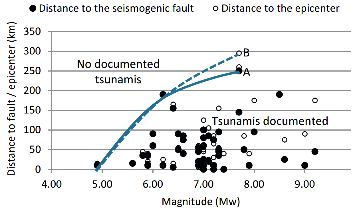 Fig. 4.
Empirical ‘Magnitude-Distance’ bounding envelopes for tsunamis generated by seismogenic submarine landslides. Filled circles denote the distance from the seismogenic fault to the landslide scar (Rf), and empty circles denote the distance between the earthquake epicenter and the landslide scar (Re). The bounding envelope of the maximal distance between the seismogenic fault and the landslide scar is delineated by line A and the bounding envelope between the epicenter and the landslide scar is denoted by the dashed line B.
Salamon and Di Manna (2019)
- Fig. 2 Aerial view of site LL from Ad et al (2018)
 Figure 2
The excavation, aerial photograph looking north
Ad et al (2018) - Fig. 3 Early phases Plan of Area LL from Ad et al (2018)
Figure 3
Plan
Ad et al (2018) - Fig. 4 Building remains and Roman floors
in a probe, looking north Ad et al (2018)
 Figure 4
Building remains and Roman floors in a probe, looking north.
Ad et al (2018) - Fig. 8 Wall Collapse in Stratum VI (Umayyad) from Ad et al (2018)
Figure 8
Wall Collapse looking west
Ad et al (2018) - Sandy Deposits Just north of Area LL
 Sandy Deposits Just north of Area LL
Click on Image for high resolution magnifiable image
Photo by Jefferson Williams on 20 April 2023 - View into room below warehouses
 View into room below warehouses
Click on Image for high resolution magnifiable image
Photo by Jefferson Williams on 20 April 2023 - Beach and Western Wall of the Warehouses in Area LL - View from South
 Beach and Western Wall of the Warehouses in Area LL - View from South
Click on Image for high resolution magnifiable image
Photo by Jefferson Williams on 20 April 2023 - Beach and Western Wall of the Warehouses in Area LL - View from North
 Beach and Western Wall of the Warehouses in Area LL - View from North
Click on Image for high resolution magnifiable image
Photo by Jefferson Williams on 20 April 2023

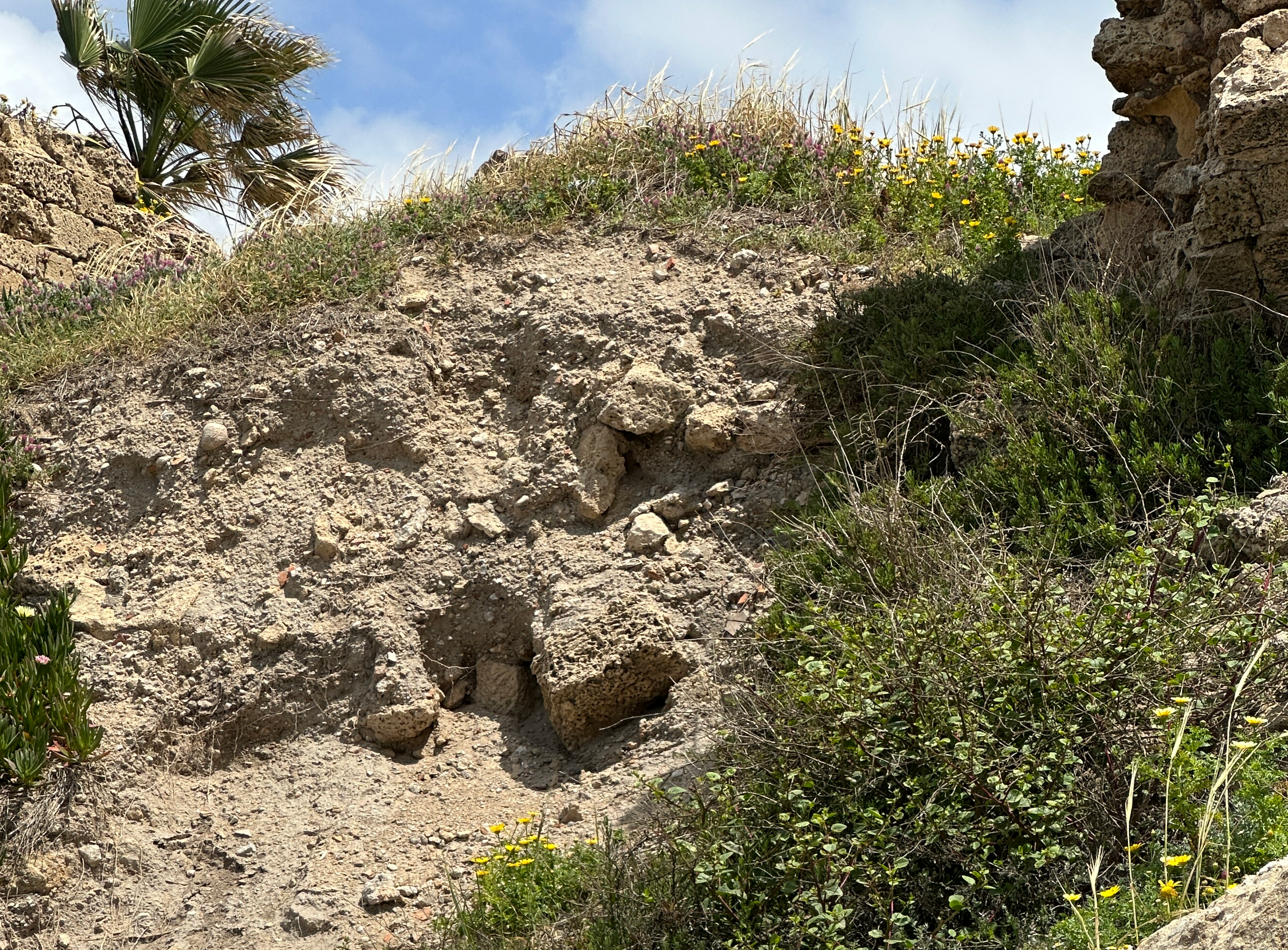


The warehouses of Area LL were built on the beach in the north part of the harbour of Caesarea. The underlying sediments are loose unconsolidated and fully saturated beach sands. There are un-excavated rooms beneath the warehouses in Area LL. Some of the sands above the beach are exposed so I examined them. They are soft, loose, and unconsolidated. This location should be highly susceptible to liquefaction during seismic shaking. I do not know how deep the original foundations were sunk.
- Fig. 4 - The Roman, Herodian harbor of Caesarea
from Galili et al (2021)
Figure 4
The Roman, Herodian harbor of Caesarea
left panel—aerial photo
right panel—artist reconstruction [43]
- Roman dock
- Roman dock
- submerged surface built of ashlars
- Crusader mole
- Beachrock deposits
Galili et al (2021) - Fig. 5 - The Caesarea region
from Galili et al (2021)
Figure 5
The Caesarea region
- Western harbor basin
- Central harbor basin
- Eastern harbor basin
Table 1 [41,43]
Galili et al (2021) - Fig. 6 - Aerial photo of the Caesarea coast
from Galili et al (2021)
Figure 6
Aerial photo of the Caesarea coast
- the location of Straton Tower quay
- the rock-cut Roman palace pool
- the Byzantine sewer outlet
- the Roman circus and the location of the Late Roman-Byzantine urban-waste fill proposed by Goodman-Tchernov and Austin as a 6th and 8th century CE tsunami deposit [9]
- abrasion platforms
- beachrock ridge marking the Roman coastline
- the missing section of the aqueduct
Table 1 [41,43]
Galili et al (2021) - Fig. 14 - Deposit of broken pottery
in the Roman circus from Galili et al (2021)
Fig. 14
A deposit of broken pottery in the Roman circus (up to 3 m thick):
- general view, looking north-east (location of scale is marked with red arrow)
- detailed view, looking west (scale in centimeters). Goodman-Tchernov and Austin [9] proposed that the fill consists of tsunamigenic deposits dated to the 6th and the 8th century CE. It should be noted that the excavator identified the deposit as Late Roman-Byzantine urban-waste fill (Porath Y. personal communication) (for location see Figures 6d and 15).
Galili et al (2021) - Fig. 15 - Location of boreholes
from Galili et al (2021)
 Fig. 15
Location of boreholes taken in coastal lowlands few kilometers south of the Caesarea harbor [91], and in Tanninim river outlet, few km north of the Caesarea harbor [92], and location of the Roman circus fill deposit
(Modified by E. Galili after Google Earth).
Galili et al (2021)
4.5.1. Archaeological Finds Presented as Evidence for a 2nd Century CE Tsunami Event
Mixed layers of sediment, described as garbage, were found in material excavated from the harbor. The excavations yielded some valuable artefacts, such as bronze figurines,
and it has been argued that the supposed garbage is actually a mixture of marine and terrestrial sediment left behind by tsunami waves [42]. However, in ancient anchorages and harbors, along the shores of Israel and beyond, the remains of numerous vessels and cargoes of ancient ships were discovered, including bronze statues and valuables (e.g., in Akko harbor, [81]). Many ships have been wrecked in the Caesarea area over the years, as evidenced by numerous finds discovered in the harbor and nearby anchorages [41], (pp. 75–112, [48]), [59,82]. It is therefore more likely that the origins of the valuable artefacts discovered within the sediments in the port originated from ships that were wrecked in and around the harbor during storms, or they were objects that fell into the water during loading or unloading of the cargo. Such finds, common in ancient harbors, may not be interpreted as unequivocal evidence of a tsunami event.
4.5.2. Sedimentological Findings at Sea Presented as Indicators of a Tsunami
The core issue in tsunami sedimentology is to distinguish tsunami deposits from beach or storm deposits. Marine fauna and marine deposits found in low-lying, lagoonal water bodies near the coast
are often used as paleo tsunami indicators, and so is the presence of large boulders on a rocky coast, away from the sea [42,83,84]. Identifying offshore tsunami deposits is more challenging. It has been less practiced, as there are very few analogies for comparison and it is hard to distinguish them from storm deposits [10,42,83]. A comprehensive study conducted by Mariner et al. [84] analyzed hundreds of published records of tsunami events in the Mediterranean and proposed that 90% of them are problematic and need to be re-examined.
4.5.3. Outside the Harbor
At a water depth of 10–12 m offshore, Reinhardt et al. (area W, [42])
identified beds of small angular shell fragments and potsherds dated from the 1st century BCE to the 1st century CE that were overlain by a layer of convex-up-oriented disarticulated bivalve shells.
Relying on the fragmentation patterns and stratigraphy of the shells, the authors assumed that these shells could be related to the 115 CE tsunami deposits.
Reinhardt et al. [42] also reported on the presence of articulated
Glycymeris shells in the tsunami deposit, and suggested that these shells indicate transport from the deeper shelf, as the shallowest
habitation depth for these bivalves is 18 m. However, no evidence for the presence of such articulated Glycymeris shells in the
discussed deposits have ever been presented or published. Furthermore, Meinis et al. [85]
noted that Glycymeris sp. (especially G. insubrica or violescens) were very common along the Israeli
coast over long periods. They existed at different depths in a coastal environment (e.g., 8–16 m depth) and even at 200 m water depth. In the Adriatic Sea, their habitat
was reported to be at a water depth of 2–40 m [86].
Moreover, Reinhardt et al. [42] give no explanation of how
these articulated mollusks survived what they describe as the “…intense wave turbulence, shell-to-shell impacts, and shells striking the harbor moles or bedrock under high wave energy,
as generated by a tsunami”. Given the above, there is nothing special in finding G. insubrica in sea bed sediments which are shallower than 18 m.
The existence of articulated Glycymeris bivalves in the discased Caesarea deposits is yet to be proven, while the preservation of such articulated
shells under a catastrophic tsunami that was assumed to destroy the Roman Harbor, is still to be explained.
As noted above, it is difficult to distinguish between tsunami and storm deposits [83,84,87,88]. Sakuna et al. [89] noted the difficulty in identifying the shallow-marine tsunami deposits associated with the 2004 Indian Ocean tsunami based on sedimentological evidence. Tamura et al. [10], who study the 2011 tsunami in Japan, concluded that this tsunami (“one of the largest modern tsunamis in the last 1200 years”) did not produce distinct sedimentary records in Sendai Bay. He also stated that there are no established unequivocal criteria for identifying shallow marine tsunami deposits and that it is impossible to identify the associated deposits at sea, since they are not preserved and might have been mixed by storms [10]. Their results agree with the suggestions of Weiss and Bahlburg [90] that the offshore tsunami deposits are unlikely to be preserved at depths shallower than 65 m. In this regard, the deposits identified by Reinhardt et al. [42] as the result of the 115 tsunami that is supposed to have destroyed the harbor, are questionable, as are the three reflected sub-bottom layers identified by Goodman-Tchernov and Austin [9] as tsunami features.
4.5.4. Tsunami Deposits in the Eastern (Inner) Basin
Excavations in the eastern basin [40]
yielded a thin layer of sediments from the 1st to 2nd centuries CE, overlain by a deposit of mixed sediments. They determined that in the 1st century, and evidently up to the 3rd century CE,
the prevailing conditions in the eastern basin were of a brackish body of water with good circulation. Thus, the inner harbor seems to have been in use after 115 CE. The mixed sediment
deposits discovered in the eastern basin was attributed by Reinhardt and Raban [40]
to cleaning and deepening of the harbor in early periods. The proposed main mechanisms for the destruction of the harbor in the study by Reinhardt and Raban
[40] were the seismic and tectonic scenarios. Later,
however, after reassessing the finds in light of the available new studies on tsunamis, the tectonic and seismic scenarios, as well as the dredging deposit
hypothesis, gave way to the 115 CE tsunami scenario [42].
4.5.5. Tsunami Deposits on Land in Caesarea
It is reasonable to assume that a powerful tsunami, such as the one suggested to have occurred in 115 CE, should have affected other places along the Caesarea region and
leave behind tsunamigenic deposits that can be traced on land in Caesarea and surrounding lowlands. Excavations carried out on the coast of Caesarea yielded deposits which were associated
with 6th and 8th century CE tsunami events (Figure 14)
[8,9].
However, so far, no tsunami deposits that can be attributed to the second century CE were reported from land excavations in Caesarea and around. Furthermore, boreholes taken in lowlands a few km north
and south of Caesarea [91,92] (Figure 15)
revealed no tsunami deposits that can be dated to 115 CE. Nonetheless, no evidence does not mean no event, and further searches for possible 115 CE tsunamigenic deposits on land is certainly
needed.
...
4.6. Swell Storms
The winter wave climate along the Mediterranean coast of Israel is characterized by alternating periods of calm seas and storm events [23,101,102,103]. Since November 1993, high-quality directional wave data have been measured simultaneously offshore Ashdod and Haifa (75 km south of Caesarea, and 37 north of Caesarea respectively) by the Coastal and Marine Engineering Research Institute. At these sites, where the water depth is about 24 m, a Wave-rider buoy was deployed to acquire 30-min records of surface elevation and directional spectral information [104]. By using the Weibull distribution with a 3.7 m significant height (Hs) threshold, a statistical analysis of extreme wave events was recorded in Ashdod during the period of 1 April 1992 and 31 March 2015. The analysis shows that the significant wave height for the 20, 50 and 100-year return period are about 7.07 m, 7.75 m, 8.27 m and 8.78 m respectively [105], with a maximum height of over 13 m [23]. Furthermore, during the last 20 years, four major storms with Hs > 7 m were measured in Haifa in Feb 2001, Dec 2002, Dec 2010 and Feb 2015. The statistical analysis, as well as the last major events, show that the Israeli coast is affected by relatively high waves [106]. These storms also induced strong longshore currents that may exceed 2 m/sec [23,103,107]. Here we discuss the potential impact of those winter storms and longshore currents.
4.6.1. Wave-Induced Seabed Liquefaction
Deposits of man-made artifacts originating from shipwrecks, shells and other natural products can be sorted and stratified below the sandy seabed in various depths by storm waves. Wave-induced seabed liquefaction of the sandy sea bed occurs at depths of up to 30 m below sea level to a depth of 3 m below seabed due to wave storms (pp. 445–509, [108]; E. Kit pers. comm. 2021). The wave-induced seabed liquefaction is maximal at water depths of 8–9 m [108]. Such liquefaction results in settlement and re-solidification [109], and may lead to sorting and stratification of artifacts and other natural products in sub-bottom horizons. Thus, the three sub-bottom horizons reported by Goodman-Tchernov and Austin [9], should also be considered as a result of wave storms effects.
4.6.2. Scouring
Fredsøe and Sumer (pp. 5–6, [108]) noted that “when a structure is placed in a marine environment, the presence of the structure will change the flow pattern in its immediate neighborhood, resulting in several phenomena: (1) the generation of turbulence; (2) the occurrence of reflection and diffraction waves; (3) the occurrence of wave breaking; (4) the pressure differentials in the soil that may produce “quick” condition/liquefaction allowing material to be carried off by currents. These changes usually cause an increase in the local sediment transport capacity and thus lead to scouring (erosion), which poses a threat to the stability of the structure”. The repeating strong waves and the currents eroding the sandy seabed on which wave breakwaters are built on cause these constructions to disintegrate and settle into the loose sand. It is thus more reasonable to assume that the breakwaters of the western basin of Caesarea Harbor underwent settlement and destruction mainly due to extreme wave storms. The structures most probably settled down because the sand they were based on was liquefied and scoured away by the winter storms pounding waves and currents. Nonetheless, rare and random earthquake and tsunami events may have also contributed to the settlement of the breakwaters and the destruction of the harbor.
- Fig. 14 - Deposit of broken pottery
in the Roman circus from Galili et al (2021)
Fig. 14
A deposit of broken pottery in the Roman circus (up to 3 m thick):
- general view, looking north-east (location of scale is marked with red arrow)
- detailed view, looking west (scale in centimeters). Goodman-Tchernov and Austin [9] proposed that the fill consists of tsunamigenic deposits dated to the 6th and the 8th century CE. It should be noted that the excavator identified the deposit as Late Roman-Byzantine urban-waste fill (Porath Y. personal communication) (for location see Figures 6d and 15).
Galili et al (2021) - Photo of the "archaeological deposit"
in the Roman Circus
 The "archaeological deposit" on the north side of the Roman Circus. View from the South
Click on Image for high resolution magnifiable image
Photo by Jefferson Williams - 20 April 2023 - Explanatory Sign
for the "archaeological deposit" in the Roman Circus
Sign from the park at Caesarea explaining the "Archaeological Deposit". Deposits are described as Late Roman and
Early Byzantine deposited in the 3rd and 4th centuries CE. Dating is presumed to be derived from pottery and stratigraphy.
Click on Image for higher resolution and slightly magnifiable image
Photo by Jefferson Williams - 20 April 2023
Fig. 14 from Galili et al (2021) contains a photo of what is called the "Archaeological Deposit" at the Archaeological Park in Caesarea. It is located on the north side of the Roman Circus (aka the Hippodrome) and in the accompanying explanatory sign the deposits are dated to the 3rd and 4th centuries CE - i.e Late Roman and Early Byzantine. Dating is presumed to be derived from pottery and stratigraphy. Galili et al (2021)'s description of this deposit in the caption of Figure 14 is accurate.
- Fig. 2 Herodian-phase mole
showing the sea levels has been stable for ~2000 years from Dey et al(2014)
Fig. 2
The harbor mole today at low tide. Dotted line highlights the Herodian-phase mole, indicating little difference in sea level relative to today.
Dey et al(2014) - Fig. 4 The Roman, Herodian
harbor of Caesarea from Galili et al (2021)
Figure 4
The Roman, Herodian harbor of Caesarea
left panel—aerial photo
right panel—artist reconstruction [43]
- Roman dock
- Roman dock
- submerged surface built of ashlars
- Crusader mole
- Beachrock deposits
Galili et al (2021) - Fig. 5 The Caesarea region
from Galili et al (2021)
Figure 5
The Caesarea region
- Western harbor basin
- Central harbor basin
- Eastern harbor basin
Table 1 [41,43]
Galili et al (2021) - Fig. 6 Aerial photo of the
Caesarea coast from Galili et al (2021)
Figure 6
Aerial photo of the Caesarea coast
- the location of Straton Tower quay
- the rock-cut Roman palace pool
- the Byzantine sewer outlet
- the Roman circus and the location of the Late Roman-Byzantine urban-waste fill proposed by Goodman-Tchernov and Austin as a 6th and 8th century CE tsunami deposit [9]
- abrasion platforms
- beachrock ridge marking the Roman coastline
- the missing section of the aqueduct
Table 1 [41,43]
Galili et al (2021)
Dey et al(2014) pointed out that the coastline at Caesarea appears to have been stable for the past ~2000 years (Fig. 2) with sea level fluctuating no more than ± 50 cm, no pronounced vertical displacement of the city's Roman aqueduct (Raban, 1989:18-21), and harbor constructions completed directly on bedrock showing no signs of subsidence.
Galili et al (2021:8-12) presented a wide array of evidence that also suggest Caesarea's coastline has been stable and sea level has been stable since
at least the Hellenistic Period.
| Item | Photos | Description |
|---|---|---|
| The quay of the Hellenistic northern harbor of Straton’s Tower | 6
Figure 6 Aerial photo of the Caesarea coast
Table 1 [41,43] Galili et al (2021) 7  Figure 7
Galili et al (2021) |
The quay (Figures 6a and 7a), described by Raban (pp. 82–84, [48]) is built of headers. It is at an elevation that still enables functioning today, suggesting stable sea-level conditions since the 2nd century BCE. |
| Harbor wharves in the central basin | 4
Figure 4 The Roman, Herodian harbor of Caesarea left panel—aerial photo right panel—artist reconstruction [43]
Galili et al (2021) 6
Figure 6Aerial photo of the Caesarea coast
Table 1 [41,43] Galili et al (2021) 7
Figure 7
Galili et al (2021) |
The wharves were built on the kurkar ridge and they retained their original level [41]: On the south-western side of this basin, a Roman quay was built of headers and it is presently at sea level (Figures 4(1) and 7b). Another quay was excavated by Raban on the northeastern side of this basin and was dated to the Herodian period (p. 86 and Figure 22, p. 115 and Figure 6, [48]) (Figures 4(2) and 7c). Both structures are currently at an elevation that enables functioning. |
| A surface built of large ashlars | 4
Figure 4 The Roman, Herodian harbor of Caesarea left panel—aerial photo right panel—artist reconstruction [43]
Galili et al (2021) 7
Figure 7
Galili et al (2021) |
The surface was discovered in the western basin at more than 5 m depth (Figures 4(3) and 7d). This structure was interpreted as a submerged pavement, supposedly indicating that the west basin of the harbor underwent tectonic subsidence and could no longer function as a port (p. 96 and Figure 38a,b [48]; [56–59]). This surface, however, could have been originally built underwater (see below). |
| Rock-cut Roman-palace pool | 6
Figure 6 Aerial photo of the Caesarea coast
Table 1 [41,43] Galili et al (2021) 8  Figure 8
The rock-cut Roman pool in the reef palace, looking south (for location see Figure 6b). Galili et al (2021) |
The rectangular basin in the southern palace (socalled Cleopatra pool) (Figures 6b and 8) (pp. 217–228, [60]), was interpreted as a swimming pool. It was operated by sea-water and its elevation still enables functioning today. |
| Roman harbor installations in the eastern basin | 4
Figure 4 The Roman, Herodian harbor of Caesarea left panel—aerial photo right panel—artist reconstruction [43]
Galili et al (2021) |
A Roman mooring stone and staircase leading to it were found on the eastern quay of the eastern basin (p. 208, [46]) (Figure 4). Their elevation enables functioning today |
| Byzantine sewer outlet in the northern anchorage | 6
Figure 6 Aerial photo of the Caesarea coast
Table 1 [41,43] Galili et al (2021) 9  Figure 9
Byzantine sewer outlet on the coast and partly submerged in the northern anchorage (marked with red arrows, for location see Figure 6c), and a beachrock ridge designating the location of the coastline before the construction of the harbor (marked with blue arrows, for location see Figure 6f), looking north. Galili et al (2021) |
The Byzantine sewer outlet has been ruined by the advancing sea (Figures 6c and 9). The ruins of this stone-built structure are now scattered along the sea bed to a distance of 35 m offshore. Originally, this indicates the location of the Byzantine coastline at the time that the sewer was still operating, some 1500 years ago. Its present location suggests that the coastline has shifted eastwards since the Byzantine period (p. 20, [41]) (Figures 6c and 9). |
| Water wells | A study of tens of water wells at Caesarea suggests that the sea level was constant in the last 2 ky, and that there were no tectonic changes in the region during that period [30,61]. |
|
| Stone-built pool near Kibbutz Sedot-Yam | 6
Figure 6 Aerial photo of the Caesarea coast
Table 1 [41,43] Galili et al (2021) 10  Figure 10
Stone-built pool near Kibbutz Sedot-Yam, looking north-west (for location see Figure 5d) [43] Galili et al (2021) |
The rectangular stone-built pool that can be filled with sea water by gravity is currently at present sea level (Figures 6d and 10). Given its building style and location (close to the southern Byzantine city wall), it can be dated to the Byzantine period. The structure could have served as a swimming pool. |
| Crusader mole in the northern part of the central basin | 5
Figure 5 The Caesarea region
Table 1 [41,43] Galili et al (2021) 11  Figure 11
. Crusader mole in the northern part of the central basin of the harbor:
Galili et al (2021) |
The Crusader mole was built of secondary-used pillars, which were placed on the flat, natural rock (probably abrasion platform). Its elevation enables functioning today (Figures 5d and 11). |
| Abrasion platforms | 6
Figure 6 Aerial photo of the Caesarea coast
Table 1 [41,43] Galili et al (2021) |
North and south of the harbor, the coastal kurkar ridge was abraded by the sea and the abrasion platforms are at the same elevation as present sea levels (Figure 6e). The abrasion platforms and wave notches in Caesarea and along the entire Carmel coast suggest stable sea-level conditions over the last few thousand years, since sea levels reached their present elevation, ca. 4 ky ago [12,29]. |
| Oysters on the quay of the eastern basin of the Roman harbor | 4
Figure 4 The Roman, Herodian harbor of Caesarea left panel—aerial photo right panel—artist reconstruction [43]
Galili et al (2021) |
The mollusks attached to the stones suggest that during the Roman Period, the water level in the eastern basin was similar to that of today (p. 208, [46]) (Figure 4(5)). |
| Beachrock north of the northern Crusader wall | 4
Figure 4 The Roman, Herodian harbor of Caesarea left panel—aerial photo right panel—artist reconstruction [43]
Galili et al (2021) 12 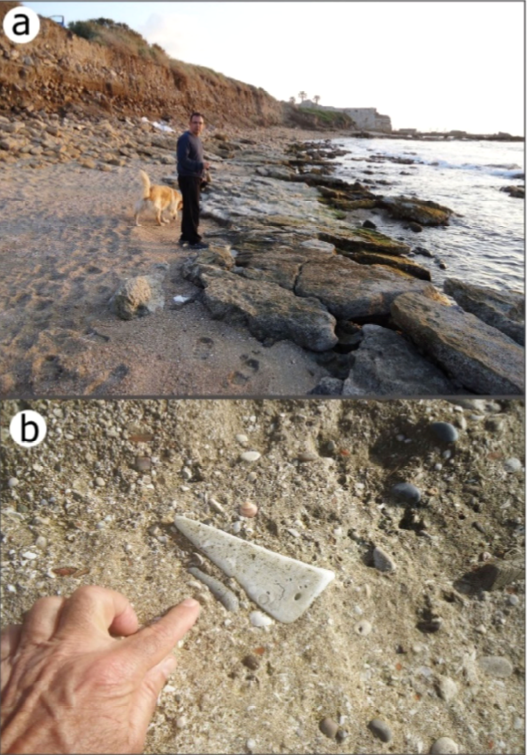 Figure 12
Beachrock north of the northern Crusader Wall:
Galili et al (2021) |
(Figures 4(6) and 12)—A 50 m long deposit of beach rock, with Roman marble chank traps in it, is attached to the kurkar rock at present day sea-level elevations, suggesting stable sea-level conditions over the last two thousand years. |
| Beach rock ridge in the northern anchorage (Figures 6f and 9) | 6
Figure 6 Aerial photo of the Caesarea coast
Table 1 [41,43] Galili et al (2021) 9
Figure 9Byzantine sewer outlet on the coast and partly submerged in the northern anchorage (marked with red arrows, for location see Figure 6c), and a beachrock ridge designating the location of the coastline before the construction of the harbor (marked with blue arrows, for location see Figure 6f), looking north. Galili et al (2021) |
A massive strip of in-situ beach rock deposit, about 2.8 m-thick, is at 0.2–3.0 m below the present sea level. The deposit is located parallel to the coast, some 60 m west of the present shore and the remains of the aqueduct foundations (Figures 9 and 6f). This beachrock probably marks the location of the ancient coastline before the construction of the harbor and the aqueduct, and indicates that the shoreline has retreated horizontally some 60 m eastwards since the construction of the Roman aqueduct. This coastline shift must have occurred under stable sea-level conditions (p. 20, [41]). |
| References Cited by Galili et al (2021) |
|
- Toe Failure at Northwest Corner of Crusader Wall
- Long shot - View from North
 Toe Failure at Northwest Corner of Crusader Wall - View from North
Click on Image for high resolution magnifiable image
Photo by Jefferson Williams on 20 April 2023 - Toe Failure at Northwest Corner of Crusader Wall
- A closer Long shot - View from North
 Toe Failure at Northwest Corner of Crusader Wall - View from North
Click on Image for high resolution magnifiable image
Photo by Jefferson Williams on 20 April 2023 - Toe Failure at Northwest Corner of Crusader Wall
- Medium shot - View from North
 Toe Failure at Northwest Corner of Crusader Wall - View from North
Click on Image for high resolution magnifiable image
Photo by Jefferson Williams on 20 April 2023 - Toe Failure at Northwest Corner of Crusader Wall
- Closeup - View from North
 Toe Failure at Northwest Corner of Crusader Wall - View from North
Click on Image for high resolution magnifiable image
Photo by Jefferson Williams on 20 April 2023