Haluza
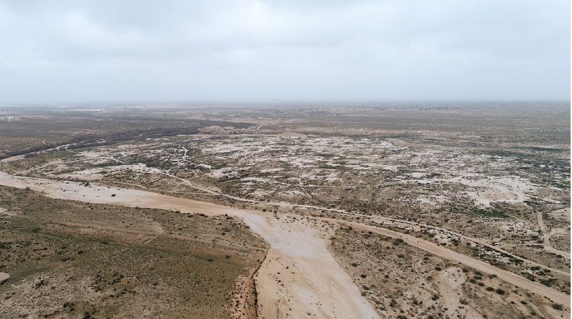 Fig. 2
Elusa (Haluza). Drone image with overview of the city area, looking N
Heinzelmann et al. (2023)
| Transliterated Name | Source | Name |
|---|---|---|
| Haluza | Hebrew | חלוצה |
| Elusa | Byzantine Greek - Madaba Map | ΕΛΟΥϹΑ |
| Chellous | Greek | Χελλοὺς |
| Halasa | ||
| asal-Khalūṣ | Arabic - Early Arab | الخلصة |
| Al-Khalasa | Modern Arabic | الخلصة |
- Fig. 1 Location Map
from Heinzelmann et al. (2023)
 Fig. 1
Elusa (Haluza) and its region in antiquity
Heinzelmann et al. (2023)
- Fig. 2 Drone Photo of Haluza
from Heinzelmann et al. (2023)
Fig. 2
Elusa (Haluza). Drone image with overview of the city area, looking N
Heinzelmann et al. (2023) - Haluza in Google Earth
 Haluza
click on image to explore this site on a new tab in Google Earth - Haluza on govmap.gov.il
 Haluza
click on image to explore this site on a new tab in govmap.gov.il
- Site Plan of Haluza
from Negev in Stern et al (1993)
 General Plan of Haluza
Stern et al (1993) - Fig. 15 Preliminary city plan
from Heinzelmann et al. (2023)
 Fig. 15
Elusa (Haluza). Preliminary city plan. The interpretation is based on geophysics, survey and remote sensing
JW: location of sondages (stratigraphic profiles) are in dicated in black starting with So
Heinzelmann et al. (2023) - Fig. 4 Map of modern Al-Khalasa
from Heinzelmann et al. (2023)
 Fig. 2
Al-Khalasa. Overview over the modern settlement which existed in the first half of the 20th century. Features based on survey and historical maps
Heinzelmann et al. (2023)
- Site Plan of Haluza
from Negev in Stern et al (1993)
General Plan of Haluza
Stern et al (1993) - Fig. 15 Preliminary city plan
from Heinzelmann et al. (2023)
Fig. 15
Elusa (Haluza). Preliminary city plan. The interpretation is based on geophysics, survey and remote sensing
JW: location of sondages (stratigraphic profiles) are in dicated in black starting with So
Heinzelmann et al. (2023) - Fig. 4 Map of modern Al-Khalasa
from Heinzelmann et al. (2023)
Fig. 2
Al-Khalasa. Overview over the modern settlement which existed in the first half of the 20th century. Features based on survey and historical maps
Heinzelmann et al. (2023)
- Fig. 17 Plan of the
northern district incl. Basilica B from Heinzelmann et al. (2023)
 Fig. 17
Elusa (Haluza). Preliminary plan of the northern district including Basilica B and the bath complex. The interpretation is based on geophysics, survey and remote sensing
Heinzelmann et al. (2023) - Fig. 42 Basilica B
survey from Heinzelmann et al. (2023)
 Fig. 42
Elusa (Haluza), Basilica B. Survey finds on the preliminary interpretation (scale 1 : 500)
Heinzelmann et al. (2023)
- Fig. 17 Plan of the
northern district incl. Basilica B from Heinzelmann et al. (2023)
Fig. 17
Elusa (Haluza). Preliminary plan of the northern district including Basilica B and the bath complex. The interpretation is based on geophysics, survey and remote sensing
Heinzelmann et al. (2023) - Fig. 42 Basilica B
survey from Heinzelmann et al. (2023)
Fig. 42
Elusa (Haluza), Basilica B. Survey finds on the preliminary interpretation (scale 1 : 500)
Heinzelmann et al. (2023)
- Fig. 8 DEM of Haluza
from Heinzelmann et al. (2023)
 Fig. 8
Elusa (Haluza). Digital elevation model based on drone images and Structure from Motion
Heinzelmann et al. (2023) - Fig. 9 Aerial Image
with geophysical survey locations from Heinzelmann et al. (2023)
 Fig. 9
Elusa (Haluza). Aerial image with indications of the geophysical investigations carried out between 2015 and 2018
Heinzelmann et al. (2023) - Fig. 11 Geomagnetic Map
from Heinzelmann et al. (2023)
 Fig. 11
Elusa (Haluza). Magnetic map of the city based on the investigations (2015-2018)
Heinzelmann et al. (2023) - Fig. 13 Archaeological
survey map from Heinzelmann et al. (2023)
 Fig. 13
Elusa (Haluza). GIS-based map with selected results of the urban survey (2015-2018)
Heinzelmann et al. (2023)
- Fig. 8 DEM of Haluza
from Heinzelmann et al. (2023)
Fig. 8
Elusa (Haluza). Digital elevation model based on drone images and Structure from Motion
Heinzelmann et al. (2023) - Fig. 9 Aerial Image
with geophysical survey locations from Heinzelmann et al. (2023)
Fig. 9
Elusa (Haluza). Aerial image with indications of the geophysical investigations carried out between 2015 and 2018
Heinzelmann et al. (2023) - Fig. 11 Geomagnetic Map
from Heinzelmann et al. (2023)
Fig. 11
Elusa (Haluza). Magnetic map of the city based on the investigations (2015-2018)
Heinzelmann et al. (2023) - Fig. 13 Archaeological
survey map from Heinzelmann et al. (2023)
Fig. 13
Elusa (Haluza). GIS-based map with selected results of the urban survey (2015-2018)
Heinzelmann et al. (2023)
- Fig. 16 Chronological overview
of sondages from Heinzelmann et al. (2023)
 Fig. 16
Elusa (Haluza), Comprehensive overview of the chronology of the different sondages
Heinzelmann et al. (2023)
- Fig. 16 Chronological overview
of sondages from Heinzelmann et al. (2023)
Fig. 16
Elusa (Haluza), Comprehensive overview of the chronology of the different sondages
Heinzelmann et al. (2023)
-
Korjenkov and and Mazor (2005) interpreted the presence of
at least two heavy earthquakes
at Haluza - It is presumed that at least some of the Seismic Effects categorized as Earthquake Damage Restorations and A Dump of Destructive Earthquake debris were a result of the 1st earthquake.
- East Church in Negev's map is referred to as the Cathedral by Korjenkov and and Mazor (2005)
| Effect | Location | Image(s) | Description |
|---|---|---|---|
| Earthquake Damage Restorations | Cathedral Fig. 2 Haluza.
Excavated part of the Nabatean-Roman-Byzantine ruins. Numbers are field stations of the present study Korjenkov and Mazor (2005) |
16  Fig. 16 Haluza.
Remnants of a wall that supported columns of the Cathedral. Note lead bundle on the left pedestal and collapse of the column fragment toward NE (Fig. 11) Korjenkov and Mazor (2005) 17  Fig. 17 Haluza
Blocked former entrance in one of the rooms of the Cathedral Korjenkov and Mazor (2005) 18  Fig. 18 Haluza
Secondary use of a column drum at the wall of a room of the Cathedral. Note a tilt of the whole wall toward NW, and blocked former entrance Korjenkov and Mazor (2005) |
Clustered repairs or changes of the building style of houses of the same age can serve as supportive evidence of a seismic origin of the deformation. These repairs and later rebuilding are usually of a lower quality than the original structures. Such poor rebuilding is typical for earthquake-prone regions in less-developed areas of the world even today.- Korjenkov and and Mazor (2005) |
| A Dump of Destructive Earthquake Debris | Dumps located northwest of Haluza are another interesting feature. Excavation of one of the dumps revealed that it did not contain kitchen refuse, as was common, but mainly fine dust and some burnt bricks and clay pipes. It is also important to mention that the pottery, discovered by Colt’s expedition of 1938 in the city dumps, was not earlier than the late Roman period. Based on these data, Negev came to the conclusion that this garbage hill, as well as other huge dumps surrounding the city, was made by the local inhabitants that cleaned dust and threatening sand dunes, which finally doomed it. Waelkens et al. (2000) described a large dump at ancient Sagalassos (SW Turkey), containing many coins, sherds, small stones and mortar fragments, including stucco, piled up against the fortification walls, so that the latter lost completely their defensive function. The authors concluded that the material inside this dump represents debris cleaned out from the city after a destructive earthquake. Existence of a significant quantity of burnt brick fragments and broken clay pipes at the Haluza dumps is an evidence of a strong earthquake, which partly or completely destroyed the city. As a result the city [was] abandoned for some time, and storms brought in dust from the desert. Later settlers cleaned the ruins from the dust, sand, broken pipes and bricks, which they could not use, but they reused sandstone and limestone blocks to restore the city. Similar dumps of garbage exist on the slopes of Avdat and the same interpretation was reached.- Korjenkov and and Mazor (2005) |
-
Korjenkov and and Mazor (2005) interpreted the presence of
at least two heavy earthquakes
at Haluza - Because the observations of Korjenkov and Mazor (1999a) are derived from what is presumed to be 2 separate earthquakes (Byzantine and post-Byzantine), it is not entirely clear which seismic effect should be assigned to which earthquake. However, as the second earthquake is thought to be associated with abandonment, it can be assumed that most seismic effects are associated with the second earthquake. Effects listed were used by Korjenkov and Mazor (1999a) to produce their estimate of seismic parameters for the 2nd earthquake.
- East Church in Negev's map is referred to as the Cathedral by Korjenkov and and Mazor (2005)
| Effect | Location | Image(s) | Description |
|---|---|---|---|
| Through-going Joints | Station 6 (Fig. 4)
Fig. 2 Haluza. Excavated part of the Nabatean-Roman-Byzantine ruins. Numbers are field stations of the present study Korjenkov and Mazor (2005) |
3
 Fig. 3
Different types of fissures in damaged walls. a. Through-going joints, supposing their seismic origin. b. Oblique cracks, which can be caused by static loading or seismic oscillations. c. Through-going joints occurred during the Tash-Pasha (Mpva = 5.0; I0 = VI–VII) earthquake of 1989 in Kyrgyzstan. d. Subvertical joint (1) and oblique fissures (2). The Suusamyr, Kyrgyzstan earthquake (1992, MS = 7.3, I0 = IX–X) Korjenkov and Mazor (2005) 4  Fig. 4 Haluza
A sub-vertical through going joint, cutting two adjacent stones, marked by arrows. At a building NW of the Theater (field station 6) Korjenkov and Mazor (2005) |
Joints crossing adjacent stones (Fig. 3 a. b) are a substantial evidence of seismic origin of deformation, i.e. opening of joints as a result of seismic vibrations. Formation of such joints has been reported in many macroseismic studies. S. Stiros supposed that opening and closing of vertical joints take place according to the direction of the acting seismic forces. For example, such joints formed in modern buildings during the Tash-Pasha (northern Kyrgyzstan) 1989 earthquake of a magnitude Mpva = 5.1 (Fig. 3 c) and Suusamyr (northern Tien Shan) 1992 earthquake of the magnitude MS = 7.3 (Fig. 3 d). Such through-going joints are formed only as a result of a high-intensity earthquake, as high energy is necessary to overcome the stress shadow of the free surfaces at the stone margins (i.e. the free space between adjacent stones).- Korjenkov and and Mazor (2005) |
| Tilted Walls | Theater (Fig. 10)
Fig. 2 Haluza. Excavated part of the Nabatean-Roman-Byzantine ruins. Numbers are field stations of the present study Korjenkov and Mazor (2005) |
9  Fig. 9
Tilt and collapse of houses during strong earthquakes. a. Collapse of roof of a shepherd’s house in the direction of the Suusamyr, Kyrgyzstan earthquake epicenter (1992, MS = 7.3, I0 = IX-X), which was independently determined by the seismic network. b. Collapse of a wall made of non-burned bricks during the Kochkor-Ata, Kyrgyzstan earthquake (1992, MLH = 6.2, I0 = VII–VIII). c. A model of house deformation Korjenkov and Mazor (2005) 10  Fig. 10 Haluza
Tilting of upper stones of a wall at the Theater Korjenkov and Mazor (2005) |
Tilting and (following) collapse of walls and columns are very common damage patterns described in many archeoseismological publications. However, tilting and collapse of buildings can be also caused by action of static loading or weathering in time, poor quality of a building or its design, consequences of military activity or deformation of building basement because of differential subsidence of the ground etc. However, a systematic pattern of the directional collapse of walls of the same trend proves a seismic origin of the damage. These patterns can be explained as an inertial response of buildings to propagation of seismic motions in the underlying grounds (Fig. 9).- Korjenkov and and Mazor (2005) |
| Perpendicular Trends of Collapsed and Preserved Arches | Theater
Fig. 2 Haluza. Excavated part of the Nabatean-Roman-Byzantine ruins. Numbers are field stations of the present study Korjenkov and Mazor (2005) |
11 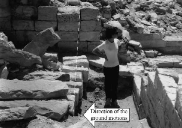 Fig. 11 Haluza
Arch stones at the Theater placed on the ground in a crescent form Korjenkov and Mazor (2005) 12  Fig. 12 Haluza
A well preserved adjacent arch with a perpendicular direction (45º) Korjenkov and Mazor (2005) |
At the ruins of ancient cities one can observe different types of arch deformations. In some cases the stones of a collapsed arch are found along a straight line on the ground, whereas in other cases arch stones are found in a crescent pattern. These cases provide indicators of the direction of the respective seismic wave propagation – at the first case the destructive seismic waves propagated parallel to the arch trend, whereas at the second case they propagated perpendicular to the arch trend. An arch at the Theater at Haluza collapsed in a crescent pattern (Fig. 11). Its trend was 130° and its stones collapsed toward 220°SW. The deviation of the collapsed stones from the straight line is 20.5 cm. This observation reveals that the propagation of the seismic waves was along a SW-NE axis. In contrast, an arch with a perpendicular strike (45°) in an adjacent room was preserved (Fig. 12).- Korjenkov and and Mazor (2005) |
| Collapse of Columns | Cathedral
Fig. 2 Haluza. Excavated part of the Nabatean-Roman-Byzantine ruins. Numbers are field stations of the present study Korjenkov and Mazor (2005) |
13  Fig. 13 Haluza
Collapse of one of the columns of the Cathedral in a NE (45º) direction. Note lead bundle on the surface of the pedestal and traces of lead on the bottom of the fallen column Korjenkov and Mazor (2005) |
Collapse of columns is a most spectacular feature of seismic destruction. A drum fragment is seen near the pedestal of a fallen eastern column in the Cathedral (Fig. 13). There are traces of lead on the surface of the pedestal, which was a binding matter between the pedestal and the upper column drum. Traces of lead were also preserved in the lower part of the column’s lower drum which collapsed toward NE45°. Thus, the seismic waves of an ancient earthquake propagated along the NE-SW axis.- Korjenkov and and Mazor (2005) |
| Shift of Building Elements | Theater (Fig. 15)
Fig. 2 Haluza. Excavated part of the Nabatean-Roman-Byzantine ruins. Numbers are field stations of the present study Korjenkov and Mazor (2005) |
14  Fig. 14
Shift of upper part of the grave monument in Belaldy village’s cemetery in the direction of the Suusamyr, Kyrgyzstan earthquake epicenter (1992, MS = 7.3, I0 = IX–X). a. Sketch b. Photograph. Korjenkov and Mazor (2005) 15  Fig. 15 Haluza
Shift of upper stone row of the SW part of the Theater wall Korjenkov and Mazor (2005) |
Horizontal shifts of the upper part of building constructions can be explained in the same way as tilting and collapse. The lower part of the structure moved together with ground onto direction of the seismic movements, but the upper part of the buildings stayed behind because of inertia (Fig. 14). Such displacements of building elements is a known phenomenon of earthquake deformation of ancient buildings and is used for determination of seismic motions’ direction, similar to the case of wall tilt and collapse.- Korjenkov and and Mazor (2005) |
-
Korjenkov and and Mazor (2005) interpreted the presence of
at least two heavy earthquakes
at Haluza - East Church in Negev's map is referred to as the Cathedral by Korjenkov and and Mazor (2005)
| Effect | Location | Image(s) | Description |
|---|---|---|---|
| Through-going Joints | Station 6 (Fig. 4)
Fig. 2 Haluza. Excavated part of the Nabatean-Roman-Byzantine ruins. Numbers are field stations of the present study Korjenkov and Mazor (2005) |
3
Fig. 3 Different types of fissures in damaged walls. a. Through-going joints, supposing their seismic origin. b. Oblique cracks, which can be caused by static loading or seismic oscillations. c. Through-going joints occurred during the Tash-Pasha (Mpva = 5.0; I0 = VI–VII) earthquake of 1989 in Kyrgyzstan. d. Subvertical joint (1) and oblique fissures (2). The Suusamyr, Kyrgyzstan earthquake (1992, MS = 7.3, I0 = IX–X) Korjenkov and Mazor (2005) 4
Fig. 4 HaluzaA sub-vertical through going joint, cutting two adjacent stones, marked by arrows. At a building NW of the Theater (field station 6) Korjenkov and Mazor (2005) |
Joints crossing adjacent stones (Fig. 3 a. b) are a substantial evidence of seismic origin of deformation, i.e. opening of joints as a result of seismic vibrations. Formation of such joints has been reported in many macroseismic studies. S. Stiros supposed that opening and closing of vertical joints take place according to the direction of the acting seismic forces. For example, such joints formed in modern buildings during the Tash-Pasha (northern Kyrgyzstan) 1989 earthquake of a magnitude Mpva = 5.1 (Fig. 3 c) and Suusamyr (northern Tien Shan) 1992 earthquake of the magnitude MS = 7.3 (Fig. 3 d). Such through-going joints are formed only as a result of a high-intensity earthquake, as high energy is necessary to overcome the stress shadow of the free surfaces at the stone margins (i.e. the free space between adjacent stones).- Korjenkov and and Mazor (2005) |
| Joints in a Staircase | Theater
Fig. 2 Haluza. Excavated part of the Nabatean-Roman-Byzantine ruins. Numbers are field stations of the present study Korjenkov and Mazor (2005) |
5
 Fig. 5 Haluza
A sub-vertical through-going joint cutting two steps in a staircase at the Theater Korjenkov and Mazor (2005) |
A subvertical joint, 58 cm long, maximal opening 1.5cm, and a strike of about 122°, crosses the staircase of the excavated theater (Fig. 5). It cuts through two adjacent staircase blocks that trend about 42°. It is important to note that all the staircase blocks are damaged to a certain degree – they are cracked.- Korjenkov and and Mazor (2005) |
| Cracks Crossing Large Building Blocks | Cathedral
Fig. 2 Haluza. Excavated part of the Nabatean-Roman-Byzantine ruins. Numbers are field stations of the present study Korjenkov and Mazor (2005) |
6
 Fig. 6 Haluza
. A sub-vertical crack, with a left-lateral slip of 1 cm, crosses the marble pedestal of a column at the Cathedral Korjenkov and Mazor (2005) |
Cracks crossing large building blocks can also be a result of a strong earthquake, but it is always complicated to prove their 100% seismic origin because the cracks can be also realization of the loading stress along the weak zone that existed in the rock. However, together with other »pure« seismic features, observed in the archaeological excavation area, these cracks can serve as an additional evidence of seismic damage. An example of such a crack was found at the marble column pedestal of the Cathedral. The pedestal of the northern column is broken by a sub vertical crack (Fig. 6). A seismic origin of this feature is supported by the left-lateral shift along the crack: it is hard to envisage that static loading can cause strike-slip movements. The left-lateral shift along the crack is 1 cm and the maximum crack opening is 1.5 cm. The crack is laterally widening toward NE (1.5cm) and narrowing toward SW (0.1 cm). The last phenomenon is difficult to explain just by loading from above. The strike azimuth of the crack is 35º and the length is 92 cm. A similar deformation can be observed at the pedestal of a column at the northern Church at Shivta- Korjenkov and and Mazor (2005) |
| Cracked Doorsteps | Station 28
Fig. 2 Haluza. Excavated part of the Nabatean-Roman-Byzantine ruins. Numbers are field stations of the present study Korjenkov and Mazor (2005) |
7  Fig. 7 Haluza
doorstep cut by two vertical cracks at the building NW of the Theater (field station 28). Note a tilt of the preserved stone row toward NE Korjenkov and Mazor (2005) |
Cracking of doorsteps is an important feature for the evaluation of a seismic damage. Their preferential occurrence in walls of the same trend can serve as a kinematic indicator of seismic motions that acted parallel to the trend of the doorstep stones.- Korjenkov and and Mazor (2005) |
| Cracked Window Beams | Cathedral
Fig. 2 Haluza. Excavated part of the Nabatean-Roman-Byzantine ruins. Numbers are field stations of the present study Korjenkov and Mazor (2005) |
8  Fig. 8 Haluza
Cracks in the window lintel and the sill, in one of the rooms of the Cathedral. a. Photograph. b. Model explaining formation of the cracks Korjenkov and Mazor (2005) |
Cracked window beams are common features of seismic damage. Many of them were observed in ancient Negev cities. As in the case with doorsteps, their preferential occurrence in walls of the same trend can serve as a kinematic indicator of seismic motions acting parallel to the trends of window beams. Generally, these data are supportive material to ›strong‹ seismic deformations, but in some cases one can prove that the crack in a beam occurred because of static loading. For example, a crack in a beam above the window (in a room behind the Cathedral) can be explained by loading from above, but it is impossible to explain a crack in the window-sill (Fig. 8 a) in the same way. The strike azimuth of both broken beams is 126°. A model explaining this damage pattern is presented in Fig. 8 b.- Korjenkov and and Mazor (2005) |
| Tilted Walls | Theater (Fig. 10)
Fig. 2 Haluza. Excavated part of the Nabatean-Roman-Byzantine ruins. Numbers are field stations of the present study Korjenkov and Mazor (2005) |
9
Fig. 9 Tilt and collapse of houses during strong earthquakes. a. Collapse of roof of a shepherd’s house in the direction of the Suusamyr, Kyrgyzstan earthquake epicenter (1992, MS = 7.3, I0 = IX-X), which was independently determined by the seismic network. b. Collapse of a wall made of non-burned bricks during the Kochkor-Ata, Kyrgyzstan earthquake (1992, MLH = 6.2, I0 = VII–VIII). c. A model of house deformation Korjenkov and Mazor (2005) 10
Fig. 10 HaluzaTilting of upper stones of a wall at the Theater Korjenkov and Mazor (2005) |
Tilting and (following) collapse of walls and columns are very common damage patterns described in many archeoseismological publications. However, tilting and collapse of buildings can be also caused by action of static loading or weathering in time, poor quality of a building or its design, consequences of military activity or deformation of building basement because of differential subsidence of the ground etc. However, a systematic pattern of the directional collapse of walls of the same trend proves a seismic origin of the damage. These patterns can be explained as an inertial response of buildings to propagation of seismic motions in the underlying grounds (Fig. 9).- Korjenkov and and Mazor (2005) |
| Perpendicular Trends of Collapsed and Preserved Arches | Theater
Fig. 2 Haluza. Excavated part of the Nabatean-Roman-Byzantine ruins. Numbers are field stations of the present study Korjenkov and Mazor (2005) |
11
Fig. 11 Haluza Arch stones at the Theater placed on the ground in a crescent form Korjenkov and Mazor (2005) 12
Fig. 12 HaluzaA well preserved adjacent arch with a perpendicular direction (45º) Korjenkov and Mazor (2005) |
At the ruins of ancient cities one can observe different types of arch deformations. In some cases the stones of a collapsed arch are found along a straight line on the ground, whereas in other cases arch stones are found in a crescent pattern. These cases provide indicators of the direction of the respective seismic wave propagation – at the first case the destructive seismic waves propagated parallel to the arch trend, whereas at the second case they propagated perpendicular to the arch trend. An arch at the Theater at Haluza collapsed in a crescent pattern (Fig. 11). Its trend was 130° and its stones collapsed toward 220°SW. The deviation of the collapsed stones from the straight line is 20.5 cm. This observation reveals that the propagation of the seismic waves was along a SW-NE axis. In contrast, an arch with a perpendicular strike (45°) in an adjacent room was preserved (Fig. 12).- Korjenkov and and Mazor (2005) |
| Collapse of Columns | Cathedral
Fig. 2 Haluza. Excavated part of the Nabatean-Roman-Byzantine ruins. Numbers are field stations of the present study Korjenkov and Mazor (2005) |
13
Fig. 13 Haluza Collapse of one of the columns of the Cathedral in a NE (45º) direction. Note lead bundle on the surface of the pedestal and traces of lead on the bottom of the fallen column Korjenkov and Mazor (2005) |
Collapse of columns is a most spectacular feature of seismic destruction. A drum fragment is seen near the pedestal of a fallen eastern column in the Cathedral (Fig. 13). There are traces of lead on the surface of the pedestal, which was a binding matter between the pedestal and the upper column drum. Traces of lead were also preserved in the lower part of the column’s lower drum which collapsed toward NE45°. Thus, the seismic waves of an ancient earthquake propagated along the NE-SW axis.- Korjenkov and and Mazor (2005) |
| Shift of Building Elements | Theater (Fig. 15)
Fig. 2 Haluza. Excavated part of the Nabatean-Roman-Byzantine ruins. Numbers are field stations of the present study Korjenkov and Mazor (2005) |
14
Fig. 14 Shift of upper part of the grave monument in Belaldy village’s cemetery in the direction of the Suusamyr, Kyrgyzstan earthquake epicenter (1992, MS = 7.3, I0 = IX–X). a. Sketch b. Photograph. Korjenkov and Mazor (2005) 15
Fig. 15 HaluzaShift of upper stone row of the SW part of the Theater wall Korjenkov and Mazor (2005) |
Horizontal shifts of the upper part of building constructions can be explained in the same way as tilting and collapse. The lower part of the structure moved together with ground onto direction of the seismic movements, but the upper part of the buildings stayed behind because of inertia (Fig. 14). Such displacements of building elements is a known phenomenon of earthquake deformation of ancient buildings and is used for determination of seismic motions’ direction, similar to the case of wall tilt and collapse.- Korjenkov and and Mazor (2005) |
| Earthquake Damage Restorations | Cathedral
Fig. 2 Haluza. Excavated part of the Nabatean-Roman-Byzantine ruins. Numbers are field stations of the present study Korjenkov and Mazor (2005) |
16
Fig. 16 Haluza. Remnants of a wall that supported columns of the Cathedral. Note lead bundle on the left pedestal and collapse of the column fragment toward NE (Fig. 11) Korjenkov and Mazor (2005) 17
Fig. 17 HaluzaBlocked former entrance in one of the rooms of the Cathedral Korjenkov and Mazor (2005) 18
Fig. 18 HaluzaSecondary use of a column drum at the wall of a room of the Cathedral. Note a tilt of the whole wall toward NW, and blocked former entrance Korjenkov and Mazor (2005) |
Clustered repairs or changes of the building style of houses of the same age can serve as supportive evidence of a seismic origin of the deformation. These repairs and later rebuilding are usually of a lower quality than the original structures. Such poor rebuilding is typical for earthquake-prone regions in less-developed areas of the world even today.- Korjenkov and and Mazor (2005) |
| Earthquake Debris Filling Part of a Corridor at the Theater | Theater
Fig. 2 Haluza. Excavated part of the Nabatean-Roman-Byzantine ruins. Numbers are field stations of the present study Korjenkov and Mazor (2005) |
19  Fig. 19
Filling of external corridor in the Buddhist Temple at Koylyk, SE Kazakhstan a. Sketch. b. Photograph Korjenkov and Mazor (2005) |
Negev observed filling of part of a corridor at the Theater, and concluded »the bones and pottery vessels appear to be contemporary with the period of use of the theatre, and they may therefore represent the remains of meals taken during religious festivities conducted in the theatre. Similar filling of a corridor, surrounding a Buddhist temple, was found at the Medieval Koylyk archeological site (SE Kazakhstan) that was located along the Great Silk Route. In this case the researcher concluded that the filling of the corridor was to prevent future collapse of walls that were tilted during an earthquake (Fig. 19).- Korjenkov and and Mazor (2005) |
| A Dump of Destructive Earthquake Debris | Dumps located northwest of Haluza are another interesting feature. Excavation of one of the dumps revealed that it did not contain kitchen refuse, as was common, but mainly fine dust and some burnt bricks and clay pipes. It is also important to mention that the pottery, discovered by Colt’s expedition of 1938 in the city dumps, was not earlier than the late Roman period. Based on these data, Negev came to the conclusion that this garbage hill, as well as other huge dumps surrounding the city, was made by the local inhabitants that cleaned dust and threatening sand dunes, which finally doomed it.- Korjenkov and and Mazor (2005) |
-
Earthquake Archeological Effects chart
of Rodríguez-Pascua et al (2013: 221-224)
 Earthquake Archeological Effects (EAE)
Rodríguez-Pascua et al (2013: 221-224)
| Effect | Location | Image(s) | Description | Intensity |
|---|---|---|---|---|
| Earthquake Damage Restorations suggesting Displaced Walls and Fallen Columns | Cathedral
Fig. 2 Haluza. Excavated part of the Nabatean-Roman-Byzantine ruins. Numbers are field stations of the present study Korjenkov and Mazor (2005) |
16
Fig. 16 Haluza. Remnants of a wall that supported columns of the Cathedral. Note lead bundle on the left pedestal and collapse of the column fragment toward NE (Fig. 11) Korjenkov and Mazor (2005) 17
Fig. 17 HaluzaBlocked former entrance in one of the rooms of the Cathedral Korjenkov and Mazor (2005) 18
Fig. 18 HaluzaSecondary use of a column drum at the wall of a room of the Cathedral. Note a tilt of the whole wall toward NW, and blocked former entrance Korjenkov and Mazor (2005) |
Clustered repairs or changes of the building style of houses of the same age can serve as supportive evidence of a seismic origin of the deformation. These repairs and later rebuilding are usually of a lower quality than the original structures. Such poor rebuilding is typical for earthquake-prone regions in less-developed areas of the world even today.- Korjenkov and and Mazor (2005) |
VII + and V+ |
-
Earthquake Archeological Effects chart
of Rodríguez-Pascua et al (2013: 221-224)
Earthquake Archeological Effects (EAE)
Rodríguez-Pascua et al (2013: 221-224)
| Effect | Location | Image(s) | Description | Intensity |
|---|---|---|---|---|
| Through-going Joints - Penetrative fractures in masonry Blocks | Station 6 (Fig. 4)
Fig. 2 Haluza. Excavated part of the Nabatean-Roman-Byzantine ruins. Numbers are field stations of the present study Korjenkov and Mazor (2005) |
3
Fig. 3 Different types of fissures in damaged walls. a. Through-going joints, supposing their seismic origin. b. Oblique cracks, which can be caused by static loading or seismic oscillations. c. Through-going joints occurred during the Tash-Pasha (Mpva = 5.0; I0 = VI–VII) earthquake of 1989 in Kyrgyzstan. d. Subvertical joint (1) and oblique fissures (2). The Suusamyr, Kyrgyzstan earthquake (1992, MS = 7.3, I0 = IX–X) Korjenkov and Mazor (2005) 4
Fig. 4 HaluzaA sub-vertical through going joint, cutting two adjacent stones, marked by arrows. At a building NW of the Theater (field station 6) Korjenkov and Mazor (2005) |
Joints crossing adjacent stones (Fig. 3 a. b) are a substantial evidence of seismic origin of deformation, i.e. opening of joints as a result of seismic vibrations. Formation of such joints has been reported in many macroseismic studies. S. Stiros supposed that opening and closing of vertical joints take place according to the direction of the acting seismic forces. For example, such joints formed in modern buildings during the Tash-Pasha (northern Kyrgyzstan) 1989 earthquake of a magnitude Mpva = 5.1 (Fig. 3 c) and Suusamyr (northern Tien Shan) 1992 earthquake of the magnitude MS = 7.3 (Fig. 3 d). Such through-going joints are formed only as a result of a high-intensity earthquake, as high energy is necessary to overcome the stress shadow of the free surfaces at the stone margins (i.e. the free space between adjacent stones).- Korjenkov and and Mazor (2005) |
VI + |
| Tilted Walls | Theater (Fig. 10)
Fig. 2 Haluza. Excavated part of the Nabatean-Roman-Byzantine ruins. Numbers are field stations of the present study Korjenkov and Mazor (2005) |
9
Fig. 9 Tilt and collapse of houses during strong earthquakes. a. Collapse of roof of a shepherd’s house in the direction of the Suusamyr, Kyrgyzstan earthquake epicenter (1992, MS = 7.3, I0 = IX-X), which was independently determined by the seismic network. b. Collapse of a wall made of non-burned bricks during the Kochkor-Ata, Kyrgyzstan earthquake (1992, MLH = 6.2, I0 = VII–VIII). c. A model of house deformation Korjenkov and Mazor (2005) 10
Fig. 10 HaluzaTilting of upper stones of a wall at the Theater Korjenkov and Mazor (2005) |
Tilting and (following) collapse of walls and columns are very common damage patterns described in many archeoseismological publications. However, tilting and collapse of buildings can be also caused by action of static loading or weathering in time, poor quality of a building or its design, consequences of military activity or deformation of building basement because of differential subsidence of the ground etc. However, a systematic pattern of the directional collapse of walls of the same trend proves a seismic origin of the damage. These patterns can be explained as an inertial response of buildings to propagation of seismic motions in the underlying grounds (Fig. 9).- Korjenkov and and Mazor (2005) |
VI + |
| Perpendicular Trends of Collapsed and Preserved Arches - Collapsed arches | Theater
Fig. 2 Haluza. Excavated part of the Nabatean-Roman-Byzantine ruins. Numbers are field stations of the present study Korjenkov and Mazor (2005) |
11
Fig. 11 Haluza Arch stones at the Theater placed on the ground in a crescent form Korjenkov and Mazor (2005) 12
Fig. 12 HaluzaA well preserved adjacent arch with a perpendicular direction (45º) Korjenkov and Mazor (2005) |
At the ruins of ancient cities one can observe different types of arch deformations. In some cases the stones of a collapsed arch are found along a straight line on the ground, whereas in other cases arch stones are found in a crescent pattern. These cases provide indicators of the direction of the respective seismic wave propagation – at the first case the destructive seismic waves propagated parallel to the arch trend, whereas at the second case they propagated perpendicular to the arch trend. An arch at the Theater at Haluza collapsed in a crescent pattern (Fig. 11). Its trend was 130° and its stones collapsed toward 220°SW. The deviation of the collapsed stones from the straight line is 20.5 cm. This observation reveals that the propagation of the seismic waves was along a SW-NE axis. In contrast, an arch with a perpendicular strike (45°) in an adjacent room was preserved (Fig. 12).- Korjenkov and and Mazor (2005) |
VI + |
| Collapse of Columns - Rotated and displaced masonry blocks in walls and drums and columns | Cathedral
Fig. 2 Haluza. Excavated part of the Nabatean-Roman-Byzantine ruins. Numbers are field stations of the present study Korjenkov and Mazor (2005) |
13
Fig. 13 Haluza Collapse of one of the columns of the Cathedral in a NE (45º) direction. Note lead bundle on the surface of the pedestal and traces of lead on the bottom of the fallen column Korjenkov and Mazor (2005) |
Collapse of columns is a most spectacular feature of seismic destruction. A drum fragment is seen near the pedestal of a fallen eastern column in the Cathedral (Fig. 13). There are traces of lead on the surface of the pedestal, which was a binding matter between the pedestal and the upper column drum. Traces of lead were also preserved in the lower part of the column’s lower drum which collapsed toward NE45°. Thus, the seismic waves of an ancient earthquake propagated along the NE-SW axis.- Korjenkov and and Mazor (2005) |
VIII + |
| Shift of Building Elements - Displaced Masonry Blocks | Theater (Fig. 15)
Fig. 2 Haluza. Excavated part of the Nabatean-Roman-Byzantine ruins. Numbers are field stations of the present study Korjenkov and Mazor (2005) |
14
Fig. 14 Shift of upper part of the grave monument in Belaldy village’s cemetery in the direction of the Suusamyr, Kyrgyzstan earthquake epicenter (1992, MS = 7.3, I0 = IX–X). a. Sketch b. Photograph. Korjenkov and Mazor (2005) 15
Fig. 15 HaluzaShift of upper stone row of the SW part of the Theater wall Korjenkov and Mazor (2005) |
Horizontal shifts of the upper part of building constructions can be explained in the same way as tilting and collapse. The lower part of the structure moved together with ground onto direction of the seismic movements, but the upper part of the buildings stayed behind because of inertia (Fig. 14). Such displacements of building elements is a known phenomenon of earthquake deformation of ancient buildings and is used for determination of seismic motions’ direction, similar to the case of wall tilt and collapse.- Korjenkov and and Mazor (2005) |
VIII + |
- Figure 4 -
from Korjenkov and Mazor (1999a)
Fig. 4 Haluza
A sub-vertical through going joint, cutting two adjacent stones, marked by arrows. At a building NW of the Theater (field station 6)
Korjenkov and Mazor (2005) - Figure 10 -
from Korjenkov and Mazor (1999a)
Fig. 10 Haluza
Tilting of upper stones of a wall at the Theater
Korjenkov and Mazor (2005) - Figure 11 -
from Korjenkov and Mazor (1999a)
Fig. 11 Haluza
Arch stones at the Theater placed on the ground in a crescent form
Korjenkov and Mazor (2005) - Figure 13 -
from Korjenkov and Mazor (1999a)
Fig. 13 Haluza
Collapse of one of the columns of the Cathedral in a NE (45º) direction. Note lead bundle on the surface of the pedestal and traces of lead on the bottom of the fallen column
Korjenkov and Mazor (2005) - Figure 15 -
from Korjenkov and Mazor (1999a)
Fig. 15 Haluza
Shift of upper stone row of the SW part of the Theater wall
Korjenkov and Mazor (2005)
Korjenkov and Mazor (1999a) estimated a minimum seismic intensity of VIII–IX (MSK Scale), an epicenter a few tens of kilometers away, and an epicentral direction to the NE or SW - most likely to the NE. Their discussion supporting these conclusions is repeated below:
Joints crossing several adjacent stones (e. g. Fig. 4) indicate destruction by a high-energy earthquake, as the energy was sufficient to overcome the stress-shadow of the empty space between the building stones. Tilts of the walls (Fig. 10), fallen columns (Fig. 13), shifted collapse of an arch (Fig. 11), shift of a stone row of the wall (Fig. 15) – all these observations disclose that the destructive seismic waves arrived along a NE-SW axis (~40º), most probably from NE. Although all of the buildings in the city were well built and had one or two floors, all of them were severely damaged by an earthquake. The significant seismic deformations observed in the buildings indicate a local seismic intensity of at least I = VIII–IX (MSK Scale). This requires a strong shock arriving from a nearby epicenter, most probably a few tens of kilometers from Haluza. This supposition is based on the fact that short-period seismic waves, which tend to be destructive to low structures (which have short-period harmonic frequencies), attenuate at short distances from the epicenter.