Petra - Petra Church (aka the Byzantine Church)
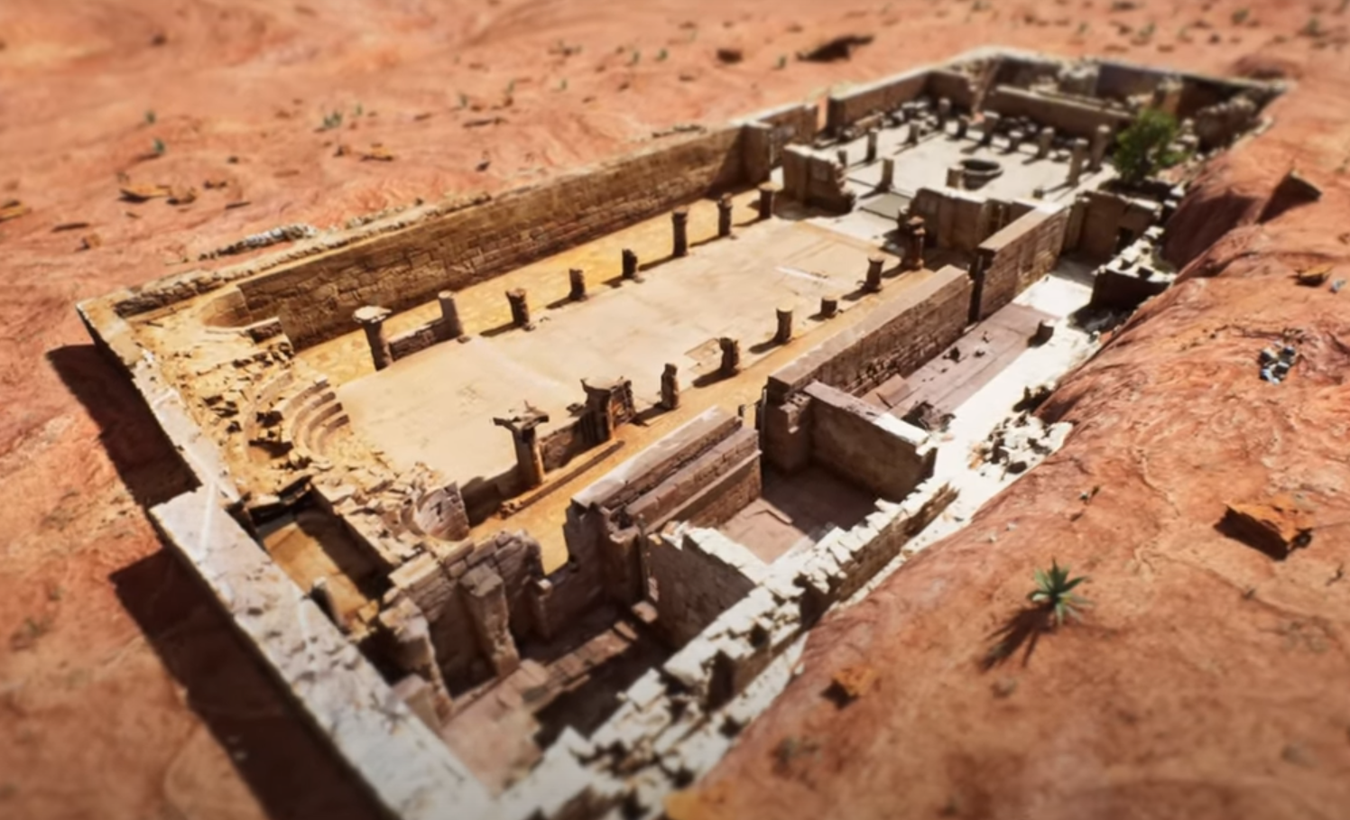 Aerial View of Virtual Reality Model of the Petra Church
Click on image to access a youtube virtual flyover video in a new tab
Zamani Project
| Transliterated Name | Source | Name |
|---|---|---|
| The Petra Church | English | |
| The Byzantine Church at Petra | English | |
| Blessed and All-Holy Lady, the most Glorious Mother of God and Ever-Virgin Mary Church |
- Fig. 2 - Location Map
from Jones (2021)
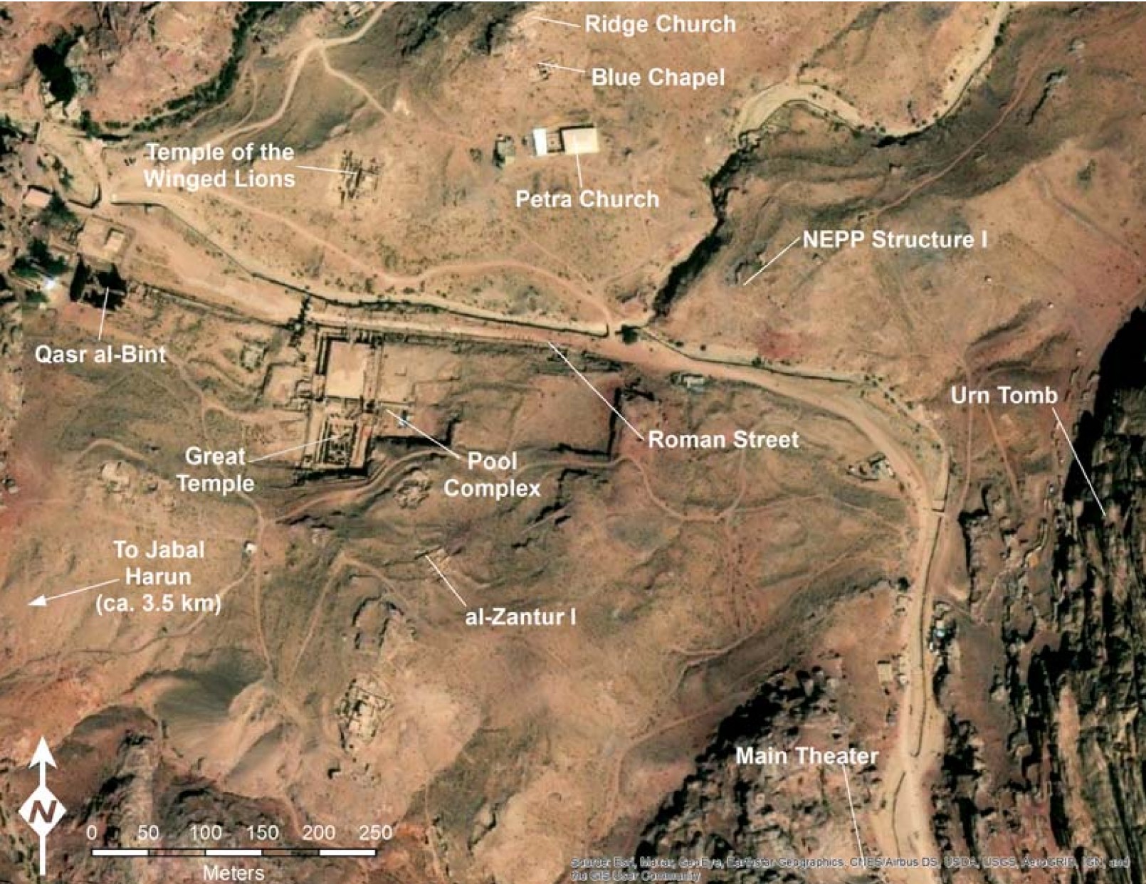 Figure 2
Map of Petra with the locations of major excavations marked
Jones (2021)
Basemap: Esri, Maxar, Earthstar Geographics, USDA FSA, USGS, Aerogrid, IGN, IGP, and the GIS User Community - Fig. 1.1 - Plan of the 3 churches
from Bikai et. al. (2020)
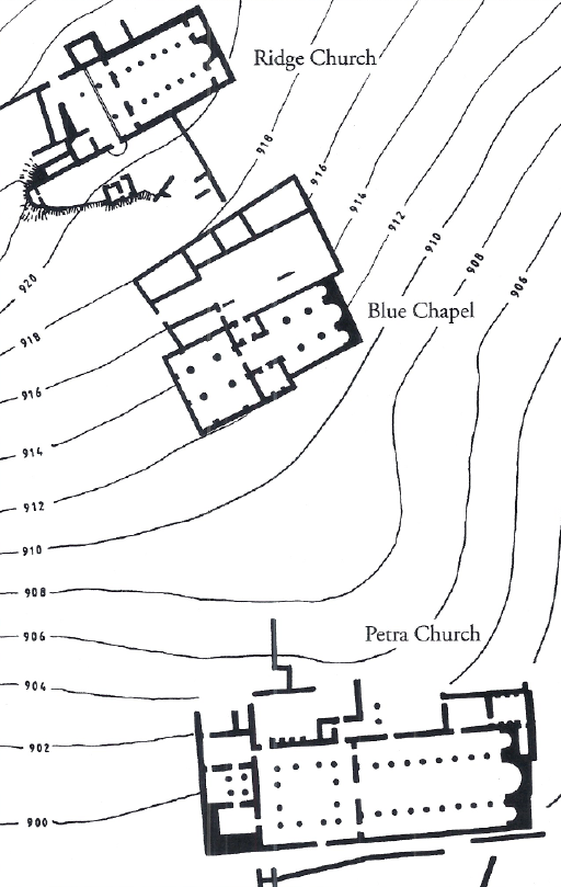 Figure 1.1
Map of the project area courtesy of Talal Akasheh, Hashemite University, Chusanthos Kanellopoulos, and American Center of Oriental Research, Amman
Bikai et al (2020) - The 3 churches in Google Earth
 The 3 churches in Google Earth
- Ridge Church on the right
- Blue Chapel in the middle
- Petra Church on the left
click on image to explore this site on a new tab in Google Earth
- Fig. 1.1 - Plan of the 3 churches
from Bikai et. al. (2020)
Figure 1.1
Map of the project area courtesy of Talal Akasheh, Hashemite University, Chusanthos Kanellopoulos, and American Center of Oriental Research, Amman
Bikai et al (2020)
- Labeled Plan modified
from Fiema et al (2001)
 Plan with parts of the structure labeled in red
modified by JW from Fig. 4a of Fiema et al (2001) - Fig. 50 - Plan of the
existing remains from Fiema et al (2001)
 Fig. 50
Ground Plan of the existing remains
Fiema et al (2001) - Plan of the existing remains
from Porter (2011)
 Map of the Petra Church showing area to be lifted at the west end of the south aisle
plan by Franco Sciorilli, 2011
Porter (2011) - Plan of the existing remains
from Zamani Project
 Byzantine Church - Groundplan
Zamani Project - Fig. 4a - General Plan
from Fiema et al (2001)
 Fig. 4a
General plan of the site, showing the locations of rooms, walls, soundings, excavation squares, and sections
Fiema et al (2001) - Fig. 4b - General Plan
with excavation squares from Fiema et al (2001)
 Fig. 4b
General plan of the site, showing the locations of rooms, walls, soundings, excavation squares, and sections
Fiema et al (2001) - Fig. 1 - Plan showing
location of Rooms I, I, and XII from Fiema (2007)
 Fig. 1
Sketch-plan of the Petra church with the locations of Rooms I and II
as modified from Fiema (2001b) 10 (C. Alexander, Z. T. Fiema and S. Shraideh)
Fiema (2007)
- Fig. 50 - Plan of the
existing remains from Fiema et al (2001)
Fig. 50
Ground Plan of the existing remains
Fiema et al (2001) - Plan of the existing remains
from Porter (2011)
Map of the Petra Church showing area to be lifted at the west end of the south aisle
plan by Franco Sciorilli, 2011
Porter (2011) - Plan of the existing remains
from Zamani Project
Byzantine Church - Groundplan
Zamani Project - Fig. 4a - General Plan
from Fiema et al (2001)
Fig. 4a
General plan of the site, showing the locations of rooms, walls, soundings, excavation squares, and sections
Fiema et al (2001) - Fig. 4b - General Plan
with excavation squares from Fiema et al (2001)
Fig. 4b
General plan of the site, showing the locations of rooms, walls, soundings, excavation squares, and sections
Fiema et al (2001)
- Fig. 16 - Axonometric
view of the basilica from Fiema et al (2001)
 Fig. 16
Axonometric view of the basilica from the northeast
Fiema et al (2001) - Fig. 62 - Perspective
view of the atrium from Fiema et al (2001)
 Fig. 62
Perspective view of the atrium
Fiema et al (2001) - Fig. 63 - Axonometric
reconstruction of the Phase V atrium from Fiema et al (2001)
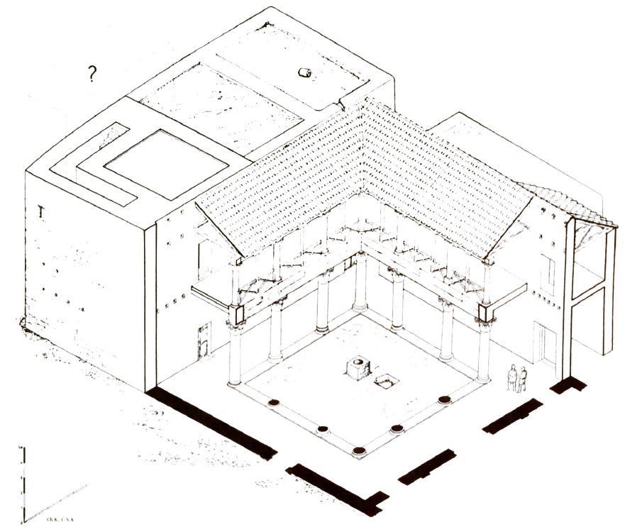 Fig. 63
Axonometric reconstruction of the Phase V atrium
Fiema et al (2001)
- Fig. 5 - Plan in Phase I
from Fiema et al (2001)
 Fig. 5
Phase I
Fiema et al (2001) - Fig. 13 - Plan in Phase II
from Fiema et al (2001)
 Fig. 13
Phase II
Fiema et al (2001) - Fig. 21 - Plan in Phase III
from Fiema et al (2001)
 Fig. 21
Phase III
Fiema et al (2001) - Fig. 26 - Drawing of interior
of Room I in Phase III from Fiema et al (2001)
 Fig. 26
Perspective view of the interior of Room I, Phase III
Fiema et al (2001) - Fig. 1a - Plan in Phase IV
from Sodini (2002)
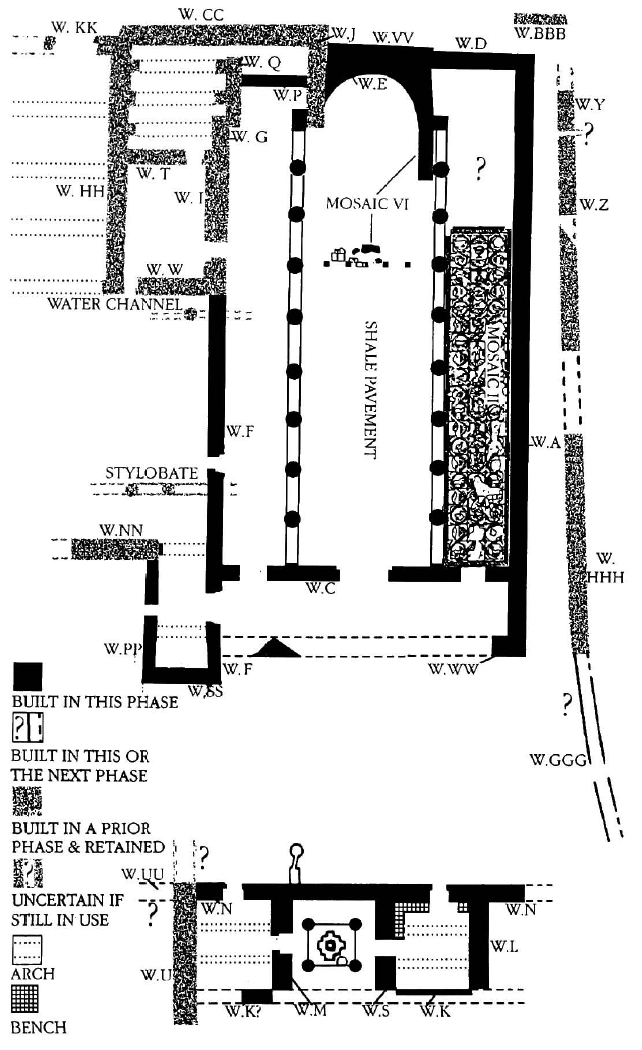 Fig. 1a
Petra church, phase IV (mid-late 5th century ?)
(fig. 39 on p. 29)
Sodini (2002) - Fig. 17 - Restored
ground plan of the complex in Phase IV from Fiema et al (2001)
 Fig. 17
Restored ground plan of the complex in Phase IV
Fiema et al (2001) - Fig. 22 - Axonometric
cutaway view of the Phase IV church with walls in front of the pastophoria from Fiema et al (2001)
 Fig. 22
Axonometric cutaway view of the Phase IV church with walls in front of the pastophoria
Fiema et al (2001) - Fig. 59 - Section through
existing remains of Rooms IX, X, and XI from Fiema et al (2001)
 Fig. 59
Section q-q' looking through Rooms IX, X, and XI, actual state
Fiema et al (2001) - Fig. 60 - Restored section
through Rooms IX, X, and XI from Fiema et al (2001)
 Fig. 60
Restored section q-q' looking east through Rooms IX, X, and XI
Fiema et al (2001) - Fig. 61 - Axonometric cutaway
of the baptisery and flanking rooms during phase IV from Fiema et al (2001)
 Fig. 61
Axonometric cutaway of the baptisery and flanking rooms during phase IV
Fiema et al (2001) - Fig. 1b - Plan in Phase V
from Sodini (2002)
 Fig. 1b
Petra church, phase V (6th century ?)
(fig. 67 on p. 54)
Sodini (2002) - Fig. IV-1 - Axonometric
reconstruction of Room I and adjacent structures in phase V from Fiema et al (2001)
 Fig. IV-1
Axonometric reconstruction of Room I and adjacent structures in phase V
Fiema et al (2001) - Fig. 24 - Axonometric
cutaway view of the church in Phase V from Fiema et al (2001)
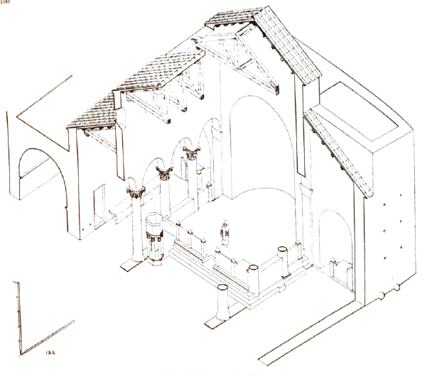 Fig. 24
Axonometric cutaway view of the church in Phase V
Fiema et al (2001) - Fig. 63 - Axonometric
reconstruction of the Phase V atrium from Fiema et al (2001)
Fig. 63
Axonometric reconstruction of the Phase V atrium
Fiema et al (2001) - Fig. 25 - Proposed
axonometric reconstruction of the complex in Phase V from Fiema et al (2001)
 Fig. 25
Proposed axonometric reconstruction of the complex in Phase V
Fiema et al (2001) - Fig. IV-2 - Proposed
reconstruction of Rooms I, II, and XII from Fiema et al (2001)
 Fig. IV-2
Proposed reconstruction of Rooms I, II, and XII
Fiema et al (2001) - Fig. 98 - Plan in Phase VI
from Fiema et al (2001)
 Fig. 98
Phase VI
Fiema et al (2001) - Fig. 110 - Plan in Phase IX
from Fiema et al (2001)
 Fig. 110
Phase IX
Fiema et al (2001) - Fig. 122 - Plan in Phase XI
from Fiema et al (2001)
 Fig. 122
Phase XI
Fiema et al (2001) - Fig. 127 - Plan in Phase XIIB
from Fiema et al (2001)
 Fig. 127
Phase XIIB
Fiema et al (2001) - Fig. 130 - Plan in Phase XIII
from Fiema et al (2001)
 Fig. 130
Phase XIII
Fiema et al (2001)
- Fig. 5 - Plan in Phase I
from Fiema et al (2001)
Fig. 5
Phase I
Fiema et al (2001) - Fig. 13 - Plan in Phase II
from Fiema et al (2001)
Fig. 13
Phase II
Fiema et al (2001) - Fig. 21 - Plan in Phase III
from Fiema et al (2001)
Fig. 21
Phase III
Fiema et al (2001) - Fig. 1a - Plan in Phase IV
from Sodini (2002)
Fig. 1a
Petra church, phase IV (mid-late 5th century ?)
(fig. 39 on p. 29)
Sodini (2002) - Fig. 1b - Plan in Phase V
from Sodini (2002)
Fig. 1b
Petra church, phase V (6th century ?)
(fig. 67 on p. 54)
Sodini (2002) - Fig. 98 - Plan in Phase VI
from Fiema et al (2001)
Fig. 98
Phase VI
Fiema et al (2001) - Fig. 110 - Plan in Phase IX
from Fiema et al (2001)
Fig. 110
Phase IX
Fiema et al (2001) - Fig. 122 - Plan in Phase XI
from Fiema et al (2001)
Fig. 122
Phase XI
Fiema et al (2001) - Fig. 127 - Plan in Phase XIIB
from Fiema et al (2001)
Fig. 127
Phase XIIB
Fiema et al (2001) - Fig. 130 - Plan in Phase XIII
from Fiema et al (2001)
Fig. 130
Phase XIII
Fiema et al (2001)
- Fig. 2 - E/W sections
from Fiema et al (2001)
 Fig. 2
E/W sections
Fiema et al (2001) - Fig. 3 - N/S sections
from Fiema et al (2001)
 Fig. 3
N/S sections
Fiema et al (2001)
- Fig. 2 - E/W sections
from Fiema et al (2001)
Fig. 2
E/W sections
Fiema et al (2001) - Fig. 3 - N/S sections
from Fiema et al (2001)
Fig. 3
N/S sections
Fiema et al (2001)
- Fig. 50 - Plan of the
existing remains from Fiema et al (2001)
Fig. 50
Ground Plan of the existing remains
Fiema et al (2001) - Plan of the existing remains
from Porter (2011)
Map of the Petra Church showing area to be lifted at the west end of the south aisle
plan by Franco Sciorilli, 2011
Porter (2011) - Fig. 4a - General Plan
from Fiema et al (2001)
Fig. 4a
General plan of the site, showing the locations of rooms, walls, soundings, excavation squares, and sections
Fiema et al (2001) - Fig. 4b - General Plan
with excavation squares from Fiema et al (2001)
Fig. 4b
General plan of the site, showing the locations of rooms, walls, soundings, excavation squares, and sections
Fiema et al (2001) - Fig. 1 - Plan showing
location of Rooms I, I, and XII from Fiema (2007)
Fig. 1
Sketch-plan of the Petra church with the locations of Rooms I and II
as modified from Fiema (2001b) 10 (C. Alexander, Z. T. Fiema and S. Shraideh)
Fiema (2007)
- Fig. 50 - Plan of the
existing remains from Fiema et al (2001)
Fig. 50
Ground Plan of the existing remains
Fiema et al (2001) - Plan of the existing remains
from Porter (2011)
Map of the Petra Church showing area to be lifted at the west end of the south aisle
plan by Franco Sciorilli, 2011
Porter (2011) - Fig. 4a - General Plan
from Fiema et al (2001)
Fig. 4a
General plan of the site, showing the locations of rooms, walls, soundings, excavation squares, and sections
Fiema et al (2001) - Fig. 4b - General Plan
with excavation squares from Fiema et al (2001)
Fig. 4b
General plan of the site, showing the locations of rooms, walls, soundings, excavation squares, and sections
Fiema et al (2001)
- Fig. 125 - Collapsed column of the
baptistery from Fiema et al (2001)
 Fig. 125
Room X, collapsed SE column of the baptistery
Color Image from ACOR website
Fiema et al (2001) - Fig. 3 - N-S section i-i'
from Fiema et al (2001)
 Fig. 3
N-S sections
Section i-i'
Fiema et al (2001) - Fig. 2 - E-W section d-d'
from Fiema et al (2001)
 Fig. 2
E-W sections
Section d-d'
Fiema et al (2001) - Fig. 126 - Plan showing
stone tumble in SE Aisle from Fiema et al (2001)
 Fig. 126
Stone tumble in the south aisle, probably Phase XIIA. A1.09, 10
Fiema et al (2001) - Fig. 2 - E-W section a-a'
from Fiema et al (2001)
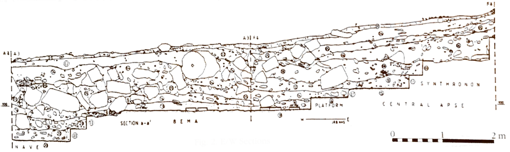 Fig. 2
E-W sections
Section a-a'
Fiema et al (2001) - Fig. 3 - N-S section b-b'
from Fiema et al (2001)
 Fig. 3
N-S sections
Section b-b'
Fiema et al (2001)
- Fig. 125 - Collapsed column of the
baptistery from Fiema et al (2001)
 Fig. 125
Room X, collapsed SE column of the baptistery
Fiema et al (2001)
This room produced the most dramatic evidence for a possible later earthquake. Two or three of the four columns which originally had supported the canopy over the baptismal font broke and collapsed on the surface of E3.30A (Fig. 125). That fall was hardly due to natural deterioration. The drums of the SE column evidently shifted and the shaft broke almost exactly at a level corresponding with the top of locus E3.30A which, by that time, had already filled up the interior. That level was ca. 899.9 m, i.e. about 1.2 m above the room's floor level. Altogether, nine drums of that column fell in a well-aligned row. Four drums of another column, the SW one, were found in the parallel row. Both rows preserved almost exact east-to-west orientation which is in striking contrast to the general north-to-south collapse observed for the first earthquake. A few drums of the third (probably NE) column and a capital fell on the same surface but not in the same orientation as the others. In addition to the column drums, collapse locus E3.29 (=D4.38) contained large quantities of ashlars and other stone material, presumably from the destruction of neighboring walls TT, S, N, and M. The presence of canopy voussoirs outside Wall TT indicates that some of them could also have fallen then, across damaged Wall TT.
- Fig. 125 - Collapsed column of the
baptistery from Fiema et al (2001)
Fig. 125
Room X, collapsed SE column of the baptistery
Color Image from ACOR website
Fiema et al (2001) - Fig. 3 - N-S section i-i'
from Fiema et al (2001)
Fig. 3
N-S sections
Section i-i'
Fiema et al (2001) - Fig. 2 - E-W section d-d'
from Fiema et al (2001)
Fig. 2
E-W sections
Section d-d'
Fiema et al (2001) - Fig. 126 - Plan showing
stone tumble in SE Aisle from Fiema et al (2001)
Fig. 126
Stone tumble in the south aisle, probably Phase XIIA. A1.09, 10
Fiema et al (2001) - Fig. 2 - E-W section a-a'
from Fiema et al (2001)
Fig. 2
E-W sections
Section a-a'
Fiema et al (2001) - Fig. 3 - N-S section b-b'
from Fiema et al (2001)
Fig. 3
N-S sections
Section b-b'
Fiema et al (2001)
In the north apse, this event was represented by an extensive stone tumble, G4.17, which was deposited in the easternmost part of the aisle, including the interior of the apse. The tumble was about 0.5 m deep, originating at ca. 900.3 m and reaching up to 900.9. Glass and stone tesserae and even marble fragments continued in this area. It is possible that a section of that tumble could have originated from stones pushed aside during the activities of the previous phase. The second collapse was also noted in J4.05, although at a slightly higher level (900.6-901 m). That tumble contained several column drums (Fig. 3, section i-i'). Unlike G4, there were practically no finds in Square J4. Locus H4.14 also contained several column drums and larger ashlars. Its bottom was at ca. 900.5 m, and it was visibly separated from the earlier earthquake destruction (Fig. 2, section d-d'). The collapsed column in H3.11, which was found at ca. 900.2 m, might have fallen then, if not before. At any rate, the remaining columns or their broken shafts would now have finally succumbed. Notably, both Squares G4 and J4 clearly preserved what may be termed a third tumble layer.
Tumbles of high density, with many ashlars, were noted in the south apse area. beginning with F2.13 (at ca. 900.2 m) and continuing through F2.10, and 08, the latter with its top at ca. 901.1 m. Like G4, these deposits contained numerous mosaic fragments, glass, plaster flakes and loose tesserae. The confluence of the apse's wall and Wall A in this area are largely responsible for the abundance of stone material there. The destruction associated with Phase XIIA is less apparent farther west in the aisle. Perhaps loci A1.09, 08, 04, B1.04, B2.04, and C1.15, 25 may represent that event, although the density of stone deposition was not high there (Fig. 126). Locus C1.15 yielded interesting, though useless, numismatic evidence. An as of Trajan, struck in commemoration of the annexation of the Nabataean kingdom in A.D. 106 was associated in that stratum with two Late Byzantine nummi from the late 5th-6th century A.D.
The apse presumably survived the first earthquake. However, it fared much less well in the current seismic event. This time the collapse appears to have been complete. Massive tumbles H1.04, 03 = A3.04 covered the area of the bema up to 901.1 m. These are probably associated with tumble loci F4.05, 04 = G2.05, 04 in the apse, which also overlapped the eastern edge of the bema (Fig. 2, section a-a' and Fig. 3, section b-b'). While the bema tumbles still contained some wall mosaic fragments, the amount of that material in the apse loci was substantially less. The pattern of these stone deposits was not clear but it appeared to concentrate toward the west, resembling the pattern noted in the baptistery. The tremor buckled and broke the structure of the semidome resulting in its fall along with the remaining mosaics upon the central and eastern bema. The upper works of the semidome probably fell straight down on the remaining part of the synthronon and the space in Square G2.
| Effect | Location | Image(s) | Description |
|---|---|---|---|
| Collapsed Columns and Walls | Atrium,
Porticoes, Aisles, Room I, and
the center of the church
Fig. 4a General plan of the site, showing the locations of rooms, walls, soundings, excavation squares, and sections Fiema et al (2001)
Fig. 4bGeneral plan of the site, showing the locations of rooms, walls, soundings, excavation squares, and sections Fiema et al (2001)
Fig. 1Sketch-plan of the Petra church with the locations of Rooms I and II as modified from Fiema (2001b) 10 (C. Alexander, Z. T. Fiema and S. Shraideh) Fiema (2007) |
|
|
| Collapsed clerestory walls above the colonnades and collapse of remaining portions of the burned out roof | clerestory walls were
visible from the south exterior of the church
Fig. 25 Proposed axonometric reconstruction of the complex in Phase V Fiema et al (2001)
Fig. 4aGeneral plan of the site, showing the locations of rooms, walls, soundings, excavation squares, and sections Fiema et al (2001)
Fig. 4bGeneral plan of the site, showing the locations of rooms, walls, soundings, excavation squares, and sections Fiema et al (2001) |
|
|
| Collapsed columns | The Nave
notably in the western and central parts including Squares B4 and A4
Fig. 4a General plan of the site, showing the locations of rooms, walls, soundings, excavation squares, and sections Fiema et al (2001)
Fig. 4bGeneral plan of the site, showing the locations of rooms, walls, soundings, excavation squares, and sections Fiema et al (2001) |
 Fig. 116
The collapse of columns associated with Phase X Fiema et al (2001)  Fig. 3
N-S sections section f-f' Fiema et al (2001)  Fig. 117
Section g-g'. J2-K1 south balk. Fiema et al (2001) |
|
| Column and Wall Collapse | Area of the
nave
and North and South Aisles including squares J4, H2, H3, and G4. Some drums
could have fallen from the top of the bema in the following phase.
Fig. 4a General plan of the site, showing the locations of rooms, walls, soundings, excavation squares, and sections Fiema et al (2001)
Fig. 4bGeneral plan of the site, showing the locations of rooms, walls, soundings, excavation squares, and sections Fiema et al (2001) |
Fig. 3 N-S sections section i-i' Fiema et al (2001)
Fig. 2E-W sections section d-d' Fiema et al (2001)  Fig. 118
North aisle. fallen column in H3.11 and note the paving slabs in the stratum below. Fiema et al (2001)  Fig. 2
E-W sections section h-h' Fiema et al (2001)  Tumble in Square H2 Loci 07 and 08 - view to south
click on image to open a new tab and see image and metadata on ACOR website ACOR website  Tumble in Square H2 Loci 07 and 08 - view to north
click on image to open a new tab and see image and metadata on ACOR website ACOR website  Square H3 Locus 16 - closeup view to north
click on image to open a new tab and see image and metadata on ACOR website ACOR website |
|
| Possible partial vault and wall collapse (stone tumble) and possible roof collapse (many roof tiles found in debris) | The Bema and Central Apse
including squares H1, G2, G4, and F4
Fig. 4a General plan of the site, showing the locations of rooms, walls, soundings, excavation squares, and sections Fiema et al (2001)
Fig. 4bGeneral plan of the site, showing the locations of rooms, walls, soundings, excavation squares, and sections Fiema et al (2001) |
Fig. 2 E-W sections section a-a' Fiema et al (2001)
Fig. 3N-S sections section b-b' Fiema et al (2001) |
|
| Minor wall displacement | The south and north side apses
(aka postophorium)
Fig. 4a General plan of the site, showing the locations of rooms, walls, soundings, excavation squares, and sections Fiema et al (2001)
Fig. 4bGeneral plan of the site, showing the locations of rooms, walls, soundings, excavation squares, and sections Fiema et al (2001) |
|
|
| Arch, column, and wall collapse | The Northern Area - Room I (western arch and perhaps other arches collapsed along with upper part of Wall G),
Room II (stone tumbles and upper floor gallery collapse above the
Portico)
Fig. 4a General plan of the site, showing the locations of rooms, walls, soundings, excavation squares, and sections Fiema et al (2001)
Fig. 4bGeneral plan of the site, showing the locations of rooms, walls, soundings, excavation squares, and sections Fiema et al (2001) |
 Fig. 119
Stone tumble in the area of Courtyard IIIA and Room II with Wall F in the center Fiema et al (2001)  Area I. Locus 09
click on image to open a new tab and see image and metadata on ACOR website ACOR website  Stone tumble. Area I. Locus 10
click on image to open a new tab and see image and metadata on ACOR website ACOR website  Area II. Locus 08
click on image to open a new tab and see image and metadata on ACOR website ACOR website |
|
| Wall collapse | The Atrium -
upper floors of the
porticoes collapsed,
the uppermost parts of Wall XX and the Portico
landed some distance south of the wall, mostly in the area of the stylobate
Fig. 4a General plan of the site, showing the locations of rooms, walls, soundings, excavation squares, and sections Fiema et al (2001)
Fig. 4bGeneral plan of the site, showing the locations of rooms, walls, soundings, excavation squares, and sections Fiema et al (2001) |
Fig. 2 E-W sections section h-h' Fiema et al (2001)  Fig. 20
Section Fiema et al (2001)
Fig. 117Section j-j', C1, west balk, Walls Y and Z, elevation Fiema et al (2001)  Fig. 120
South portico of the atrium. collapse of the portico's gallery (D1.11) Fiema et al (2001)  Fig. 121
Collapse of paving stones from the gallery of the south portico, associated with Phase X, D1.07, 11, 12, 13, 14 Fiema et al (2001) |
|
| Collapsed Walls | The Western Rooms - Room XI (southern and western walls collapsed into a thick tumble - indications of 2nd story collapse from pavers),
Room X (stone tumble), large accumulation of
ashlars
observable along Wall TT
Fig. 4a General plan of the site, showing the locations of rooms, walls, soundings, excavation squares, and sections Fiema et al (2001)
Fig. 4bGeneral plan of the site, showing the locations of rooms, walls, soundings, excavation squares, and sections Fiema et al (2001) |
 Pavement. Area X. Sq. E3 (=D4); Loci 30, 31, 32
click on image to open a new tab and see image and metadata on ACOR website ACOR website |
|
| Fractures, folds and popups on regular pavements | Damage to the Mosaic Floors in some areas of both the north and south aisles
particularly visible in the east part of the south aisle, and in the western half of the north aisle, but not restricted to these areas
Fig. 4a General plan of the site, showing the locations of rooms, walls, soundings, excavation squares, and sections Fiema et al (2001)
Fig. 4bGeneral plan of the site, showing the locations of rooms, walls, soundings, excavation squares, and sections Fiema et al (2001) |
|
|
| Perhaps multi-episode Stone collapse | South (east?) Exterior of the Church and in Squares F2 and A1
Fig. 4a General plan of the site, showing the locations of rooms, walls, soundings, excavation squares, and sections Fiema et al (2001)
Fig. 4bGeneral plan of the site, showing the locations of rooms, walls, soundings, excavation squares, and sections Fiema et al (2001) |
Fig. 3 N-S sections section b-b' Fiema et al (2001)  Fig. 6
Fiema et al (2001)  Fig. 7
Walls Y and Z, conduit F2.41 Fiema et al (2001) |
|
| Effect | Location | Image(s) | Description |
|---|---|---|---|
| Fallen Columns | Room X
Fig. 4a General plan of the site, showing the locations of rooms, walls, soundings, excavation squares, and sections Fiema et al (2001)
Fig. 4bGeneral plan of the site, showing the locations of rooms, walls, soundings, excavation squares, and sections Fiema et al (2001) |
Fig. 125 Room X, collapsed SE column of the baptistery Color Image from ACOR website Fiema et al (2001) |
Two or three of the four columns which originally had supported the canopy over the baptismal font broke and collapsed on the surface of E3.30A (Fig. 125).- Fiema et al (2001:115-117) |
| Collapsed Walls surmised from ashlar tumble | Room X
Fig. 4a General plan of the site, showing the locations of rooms, walls, soundings, excavation squares, and sections Fiema et al (2001)
Fig. 4bGeneral plan of the site, showing the locations of rooms, walls, soundings, excavation squares, and sections Fiema et al (2001) |
large quantities of ashlars and other stone material, presumably from the destruction of neighboring walls TT, S, N, and M.- Fiema et al (2001:115-117) |
|
| Collapsed Vaults | Room X
Fig. 4a General plan of the site, showing the locations of rooms, walls, soundings, excavation squares, and sections Fiema et al (2001)
Fig. 4bGeneral plan of the site, showing the locations of rooms, walls, soundings, excavation squares, and sections Fiema et al (2001) |
The presence of canopy voussoirs outside Wall TT indicates that some of them could also have fallen then, across damaged Wall TT.- Fiema et al (2001:115-117) |
|
| Fallen Columns | Aisles and Apses
Fig. 4a General plan of the site, showing the locations of rooms, walls, soundings, excavation squares, and sections Fiema et al (2001)
Fig. 4bGeneral plan of the site, showing the locations of rooms, walls, soundings, excavation squares, and sections Fiema et al (2001) |
Fig. 3 N-S sections Section i-i' Fiema et al (2001) |
That tumble contained several column drums (Fig. 3, section i-i'). ... At any rate, the remaining columns or their broken shafts would now have finally succumbed.- Fiema et al (2001:115-117) |
| Collapsed Walls surmised from ashlar tumble | Aisles and Apses
Fig. 4a General plan of the site, showing the locations of rooms, walls, soundings, excavation squares, and sections Fiema et al (2001)
Fig. 4bGeneral plan of the site, showing the locations of rooms, walls, soundings, excavation squares, and sections Fiema et al (2001) |
Fig. 2 E-W sections Section d-d' Fiema et al (2001) |
Locus H4.14 also contained several column drums and larger ashlars. Its bottom was at ca. 900.5 m, and it was visibly separated from the earlier earthquake destruction (Fig. 2, section d-d'). ... Tumbles of high density, with many ashlars, were noted in the south apse area.- Fiema et al (2001:115-117) |
| Collapsed Vaults | Apse
Fig. 4a General plan of the site, showing the locations of rooms, walls, soundings, excavation squares, and sections Fiema et al (2001)
Fig. 4bGeneral plan of the site, showing the locations of rooms, walls, soundings, excavation squares, and sections Fiema et al (2001) |
The apse presumably survived the first earthquake. However, it fared much less well in the current seismic event. This time the collapse appears to have been complete. ... The tremor buckled and broke the structure of the semidome resulting in its fall along with the remaining mosaics upon the central and eastern bema. The upper works of the semidome probably fell straight down on the remaining part of the synthronon and the space in Square G2.- Fiema et al (2001:115-117) |
|
| Collapsed Walls | Atrium
Fig. 4a General plan of the site, showing the locations of rooms, walls, soundings, excavation squares, and sections Fiema et al (2001)
Fig. 4bGeneral plan of the site, showing the locations of rooms, walls, soundings, excavation squares, and sections Fiema et al (2001) |
Walls N and YY probably suffered much damage during that seismic episode, although human interference in the subsequent phase would have been instrumental in changing the pattern of stone collapse. By then Wall YY was already reduced to a height of barely 1 m above the floor, either by natural or human forces since Wall B, probably constructed in Phase XIIB, encroached on its remains.- Fiema et al (2001:115-117) |
- Modified by JW from Fiema et al (2001)
- Some of the specific structures which fell or were damaged (e.g. columns and walls) are guesstimated
- Fiema et al (2001) noted a preferred N-S direction of collapse in this phase
 Deformation Map
click on image to open a higher resolution magnifiable image in a new tab
modified by JW from Figure 4a of Fiema et al (2001)
- Modified by JW from Fiema et al (2001)
- Some of the specific structures which fell (e.g. columns and walls surrounding the nave and columns over the baptistery) are guesstimated
- Fiema et al (2001) noted a preferred E-W direction of collapse in this phase
 Deformation Map
click on image to open a higher resolution magnifiable image in a new tab
modified by JW from Figure 4a of Fiema et al (2001)
- Modified by JW from Fiema et al (2001)
- Some of the specific structures which fell or were damaged (e.g. columns and walls) are guesstimated
- Fiema et al (2001) noted a preferred N-S direction of collapse in Phase X (left)
- Fiema et al (2001) noted a preferred E-W direction of collapse in Phase XIIA (right)
Deformation Mapmodified by JW from Figure 4a of Fiema et al (2001)
- Earthquake Archeological Effects chart
of Rodríguez-Pascua et al (2013: 221-224)
 Earthquake Archeological Effects (EAE)
Rodríguez-Pascua et al (2013: 221-224)
| Effect | Location | Image(s) | Description | Intensity |
|---|---|---|---|---|
| Re-used ashlars (suggesting collapsed Walls) |
Petra Church | there was seemingly no shortage of architectural elements - including doorjambs, drums, cornices and ashlars - which were reused- Fiema et al (2001:18) |
VIII+ | |
| Re-used drums (suggesting displaced columns and drums) |
Petra Church | there was seemingly no shortage of architectural elements - including doorjambs, drums, cornices and ashlars - which were reused- Fiema et al (2001:18) |
VIII+ | |
| Demolition evidence | Petra Church | massive backfilling of certain spaces with material clearly originating from a demolition- Fiema et al (2001:18) |
? | |
| Re-used building elements | Petra Church | One telling indication that Phase III was initiated after a devastating earth tremor is the amount of reused stone material, presumably readily available after the disaster. In all the stone-tumble layers excavated in the interiors of the northern rooms and courts - almost 4 m deep - the number of reused doorjambs was simply astonishing. In total, 275 complete stones or recognizable fragments were retrieved from that area.- Fiema et al (2001:18) |
? |
- Earthquake Archeological Effects chart
of Rodríguez-Pascua et al (2013: 221-224)
Earthquake Archeological Effects (EAE)
Rodríguez-Pascua et al (2013: 221-224)
| Effect | Location | Image(s) | Description | Intensity |
|---|---|---|---|---|
| Collapsed Columns and Walls | Atrium,
Porticoes, Aisles, Room I, and
the center of the church
Fig. 4a General plan of the site, showing the locations of rooms, walls, soundings, excavation squares, and sections Fiema et al (2001)
Fig. 4bGeneral plan of the site, showing the locations of rooms, walls, soundings, excavation squares, and sections Fiema et al (2001)
Fig. 1Sketch-plan of the Petra church with the locations of Rooms I and II as modified from Fiema (2001b) 10 (C. Alexander, Z. T. Fiema and S. Shraideh) Fiema (2007) |
|
VIII+ | |
| Collapsed clerestory walls above the colonnades and collapse of remaining portions of the burned out roof | clerestory walls were
visible from the south exterior of the church
Fig. 25 Proposed axonometric reconstruction of the complex in Phase V Fiema et al (2001)
Fig. 4aGeneral plan of the site, showing the locations of rooms, walls, soundings, excavation squares, and sections Fiema et al (2001)
Fig. 4bGeneral plan of the site, showing the locations of rooms, walls, soundings, excavation squares, and sections Fiema et al (2001) |
|
VIII+ | |
| Collapsed columns | The Nave
notably in the western and central parts including Squares B4 and A4
Fig. 4a General plan of the site, showing the locations of rooms, walls, soundings, excavation squares, and sections Fiema et al (2001)
Fig. 4bGeneral plan of the site, showing the locations of rooms, walls, soundings, excavation squares, and sections Fiema et al (2001) |
Fig. 116 The collapse of columns associated with Phase X Fiema et al (2001)
Fig. 3N-S sections section f-f' Fiema et al (2001)
Fig. 117Section g-g'. J2-K1 south balk. Fiema et al (2001) |
|
V+ or VIII+ |
| Column and Wall Collapse | Area of the
nave
and North and South Aisles including squares J4, H2, H3, and G4. Some drums
could have fallen from the top of the bema in the following phase.
Fig. 4a General plan of the site, showing the locations of rooms, walls, soundings, excavation squares, and sections Fiema et al (2001)
Fig. 4bGeneral plan of the site, showing the locations of rooms, walls, soundings, excavation squares, and sections Fiema et al (2001) |
Fig. 3 N-S sections section i-i' Fiema et al (2001)
Fig. 2E-W sections section d-d' Fiema et al (2001)
Fig. 118North aisle. fallen column in H3.11 and note the paving slabs in the stratum below. Fiema et al (2001)
Fig. 2E-W sections section h-h' Fiema et al (2001)
Tumble in Square H2 Loci 07 and 08 - view to southclick on image to open a new tab and see image and metadata on ACOR website ACOR website
Tumble in Square H2 Loci 07 and 08 - view to northclick on image to open a new tab and see image and metadata on ACOR website ACOR website
Square H3 Locus 16 - closeup view to northclick on image to open a new tab and see image and metadata on ACOR website ACOR website |
|
|
| Possible partial vault and wall collapse (stone tumble) and possible roof collapse (many roof tiles found in debris) | The Bema and Central Apse
including squares H1, G2, G4, and F4
Fig. 4a General plan of the site, showing the locations of rooms, walls, soundings, excavation squares, and sections Fiema et al (2001)
Fig. 4bGeneral plan of the site, showing the locations of rooms, walls, soundings, excavation squares, and sections Fiema et al (2001) |
Fig. 2 E-W sections section a-a' Fiema et al (2001)
Fig. 3N-S sections section b-b' Fiema et al (2001) |
|
VIII+ |
| Minor wall displacement | The south and north side apses
(aka postophorium)
Fig. 4a General plan of the site, showing the locations of rooms, walls, soundings, excavation squares, and sections Fiema et al (2001)
Fig. 4bGeneral plan of the site, showing the locations of rooms, walls, soundings, excavation squares, and sections Fiema et al (2001) |
|
VII+ | |
| Arch, column, and wall collapse | The Northern Area - Room I (western arch and perhaps other arches collapsed along with upper part of Wall G),
Room II (stone tumbles and upper floor gallery collapse above the
Portico)
Fig. 4a General plan of the site, showing the locations of rooms, walls, soundings, excavation squares, and sections Fiema et al (2001)
Fig. 4bGeneral plan of the site, showing the locations of rooms, walls, soundings, excavation squares, and sections Fiema et al (2001) |
Fig. 119 Stone tumble in the area of Courtyard IIIA and Room II with Wall F in the center Fiema et al (2001)
Area I. Locus 09click on image to open a new tab and see image and metadata on ACOR website ACOR website
Stone tumble. Area I. Locus 10click on image to open a new tab and see image and metadata on ACOR website ACOR website
Area II. Locus 08click on image to open a new tab and see image and metadata on ACOR website ACOR website |
|
|
| Wall collapse | The Atrium -
upper floors of the
porticoes collapsed,
the uppermost parts of Wall XX and the Portico
landed some distance south of the wall, mostly in the area of the stylobate
Fig. 4a General plan of the site, showing the locations of rooms, walls, soundings, excavation squares, and sections Fiema et al (2001)
Fig. 4bGeneral plan of the site, showing the locations of rooms, walls, soundings, excavation squares, and sections Fiema et al (2001) |
Fig. 2 E-W sections section h-h' Fiema et al (2001)
Fig. 20Section Fiema et al (2001)
Fig. 117Section j-j', C1, west balk, Walls Y and Z, elevation Fiema et al (2001)
Fig. 120South portico of the atrium. collapse of the portico's gallery (D1.11) Fiema et al (2001)
Fig. 121Collapse of paving stones from the gallery of the south portico, associated with Phase X, D1.07, 11, 12, 13, 14 Fiema et al (2001) |
|
VIII+ |
| Collapsed Walls | The Western Rooms - Room XI (southern and western walls collapsed into a thick tumble - indications of 2nd story collapse from pavers),
Room X (stone tumble), large accumulation of
ashlars
observable along Wall TT
Fig. 4a General plan of the site, showing the locations of rooms, walls, soundings, excavation squares, and sections Fiema et al (2001)
Fig. 4bGeneral plan of the site, showing the locations of rooms, walls, soundings, excavation squares, and sections Fiema et al (2001) |
Pavement. Area X. Sq. E3 (=D4); Loci 30, 31, 32 click on image to open a new tab and see image and metadata on ACOR website ACOR website |
|
VIII+ |
| Fractures, folds and popups on regular pavements | Damage to the Mosaic Floors in some areas of both the north and south aisles
particularly visible in the east part of the south aisle, and in the western half of the north aisle, but not restricted to these areas
Fig. 4a General plan of the site, showing the locations of rooms, walls, soundings, excavation squares, and sections Fiema et al (2001)
Fig. 4bGeneral plan of the site, showing the locations of rooms, walls, soundings, excavation squares, and sections Fiema et al (2001) |
|
VI+ | |
| Perhaps multi-episode Stone collapse | South (east?) Exterior of the Church and in Squares F2 and A1
Fig. 4a General plan of the site, showing the locations of rooms, walls, soundings, excavation squares, and sections Fiema et al (2001)
Fig. 4bGeneral plan of the site, showing the locations of rooms, walls, soundings, excavation squares, and sections Fiema et al (2001) |
Fig. 3 N-S sections section b-b' Fiema et al (2001)
Fig. 6Fiema et al (2001)
Fig. 7Walls Y and Z, conduit F2.41 Fiema et al (2001) |
|
VIII+ |
- Earthquake Archeological Effects chart
of Rodríguez-Pascua et al (2013: 221-224)
Earthquake Archeological Effects (EAE)
Rodríguez-Pascua et al (2013: 221-224)
| Effect | Location | Image(s) | Description | Intensity |
|---|---|---|---|---|
| Collapsed Walls | Atrium
Fig. 4a General plan of the site, showing the locations of rooms, walls, soundings, excavation squares, and sections Fiema et al (2001)
Fig. 4bGeneral plan of the site, showing the locations of rooms, walls, soundings, excavation squares, and sections Fiema et al (2001) |
Walls N and YY probably suffered much damage during that seismic episode, although human interference in the subsequent phase would have been instrumental in changing the pattern of stone collapse. By then Wall YY was already reduced to a height of barely 1 m above the floor, either by natural or human forces since Wall B, probably constructed in Phase XIIB, encroached on its remains.- Fiema et al (2001:115-117) |
VIII+ | |
| Collapsed Walls surmised from ashlar tumble | Aisles and Apses
Fig. 4a General plan of the site, showing the locations of rooms, walls, soundings, excavation squares, and sections Fiema et al (2001)
Fig. 4bGeneral plan of the site, showing the locations of rooms, walls, soundings, excavation squares, and sections Fiema et al (2001) |
Fig. 2 E-W sections Section d-d' Fiema et al (2001) |
Locus H4.14 also contained several column drums and larger ashlars. Its bottom was at ca. 900.5 m, and it was visibly separated from the earlier earthquake destruction (Fig. 2, section d-d'). ... Tumbles of high density, with many ashlars, were noted in the south apse area.- Fiema et al (2001:115-117) |
VIII+ |
| Collapsed Walls surmised from ashlar tumble | Room X
Fig. 4a General plan of the site, showing the locations of rooms, walls, soundings, excavation squares, and sections Fiema et al (2001)
Fig. 4bGeneral plan of the site, showing the locations of rooms, walls, soundings, excavation squares, and sections Fiema et al (2001) |
large quantities of ashlars and other stone material, presumably from the destruction of neighboring walls TT, S, N, and M.- Fiema et al (2001:115-117) |
VIII+ | |
| Collapsed Vaults (?) | Room X
Fig. 4a General plan of the site, showing the locations of rooms, walls, soundings, excavation squares, and sections Fiema et al (2001)
Fig. 4bGeneral plan of the site, showing the locations of rooms, walls, soundings, excavation squares, and sections Fiema et al (2001) |
The presence of canopy voussoirs outside Wall TT indicates that some of them could also have fallen then, across damaged Wall TT.- Fiema et al (2001:115-117) |
VIII+ | |
| Collapsed Vaults | Apse
Fig. 4a General plan of the site, showing the locations of rooms, walls, soundings, excavation squares, and sections Fiema et al (2001)
Fig. 4bGeneral plan of the site, showing the locations of rooms, walls, soundings, excavation squares, and sections Fiema et al (2001) |
The apse presumably survived the first earthquake. However, it fared much less well in the current seismic event. This time the collapse appears to have been complete. ... The tremor buckled and broke the structure of the semidome resulting in its fall along with the remaining mosaics upon the central and eastern bema. The upper works of the semidome probably fell straight down on the remaining part of the synthronon and the space in Square G2.- Fiema et al (2001:115-117) |
VIII+ | |
| Rotated and displaced masonry blocks in walls and drums and columns | Aisles and Apses
Fig. 4a General plan of the site, showing the locations of rooms, walls, soundings, excavation squares, and sections Fiema et al (2001)
Fig. 4bGeneral plan of the site, showing the locations of rooms, walls, soundings, excavation squares, and sections Fiema et al (2001) |
Fig. 3 N-S sections Section i-i' Fiema et al (2001) |
That tumble contained several column drums (Fig. 3, section i-i'). ... At any rate, the remaining columns or their broken shafts would now have finally succumbed.- Fiema et al (2001:115-117) |
VIII+ |
| Rotated and displaced masonry blocks in walls and drums and columns | Room X
Fig. 4a General plan of the site, showing the locations of rooms, walls, soundings, excavation squares, and sections Fiema et al (2001)
Fig. 4bGeneral plan of the site, showing the locations of rooms, walls, soundings, excavation squares, and sections Fiema et al (2001) |
Fig. 125 Room X, collapsed SE column of the baptistery Color Image from ACOR website Fiema et al (2001) |
Two or three of the four columns which originally had supported the canopy over the baptismal font broke and collapsed on the surface of E3.30A (Fig. 125).- Fiema et al (2001:115-117) |
VIII+ |
| Figure | Image | Description | Source |
|---|---|---|---|
| 4c |
 Figure 4c
Petra Church through-going cracks in the Great Church of Petra, piercing several stone blocks. For them to arise. A huge amount of energy needs to be released. Korzhenkov et al (2016) |
through-going cracks | Korzhenkov et al (2016) |