Omrit
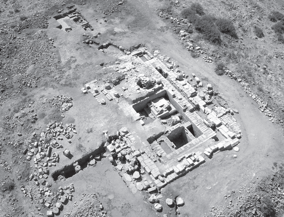 Horvat Omrit - View of the Temple Complex
Stern et al (2008)
| Transliterated Name | Source | Name |
|---|---|---|
| Omrit | Hebrew | אומריט |
| Horbat Omrit | Hebrew | הורבט אומריט |
- Omrit in Google Earth
 Omrit in Google Earth
click on image to explore this site on a new tab in Google Earth - Omrit on govmap.gov.il
 Omrit on govmap.gov.il
click on image to explore this site on a new tab in govmap.gov.il
- Plan of Horvat Omrit Site
from Stern et al (2008)
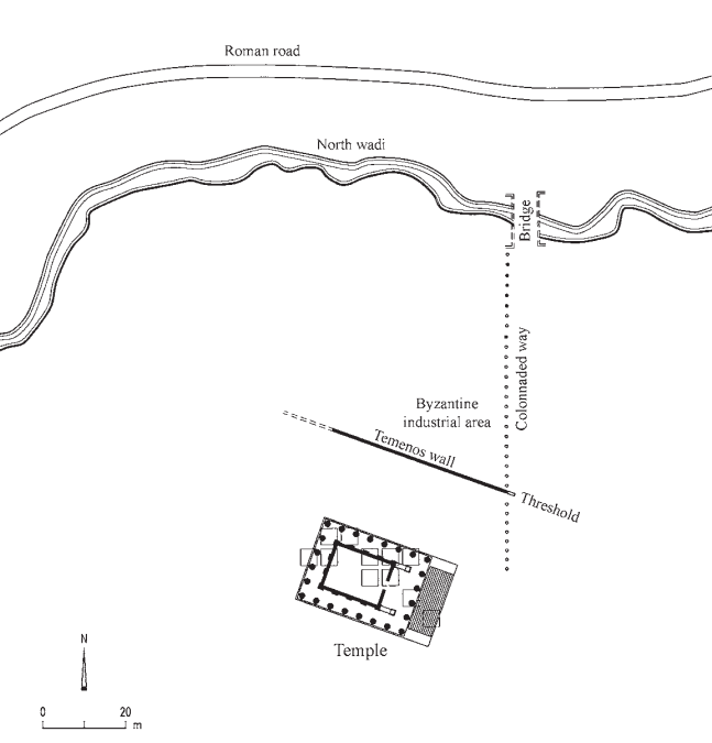 Horvat Omrit, Plan of the Site
Stern et al (2008)
- Reconstruction of the
Temple at Omrit from Wikipedia
 Omrit (Hebrew: חורבת עומרית, romanized: Horvat Omrit) is the site of an ancient Roman temple in
the northeast corner of the Hula Valley in Israel, near the modern moshav of She'ar Yashuv. It is believed that Omrit
was built by Herod the Great in honor of Emperor Augustus around 20 BCE.
Omrit (Hebrew: חורבת עומרית, romanized: Horvat Omrit) is the site of an ancient Roman temple in
the northeast corner of the Hula Valley in Israel, near the modern moshav of She'ar Yashuv. It is believed that Omrit
was built by Herod the Great in honor of Emperor Augustus around 20 BCE.
Picture is from the Israel Museum in Jerusalem
Click on Image to see magnifiable high res version in a new tab
Tom Bahar - Wikipedia - CC BY-SA 4.0 - Plan of Temple I (late 1st century BCE)
from Stern et al (2008)
 Temple I - late 1st century BCE
Stern et al (2008) - Plan of Temple II (early 2nd century CE)
from Stern et al (2008)
 Temple II - early 2nd century CE
Stern et al (2008) - Fig. 15 - Temple I & Temple II
site plan from Nelson et al (2015)
 Figure 15
T1 and T2 state plan.
Nelson et al (2015) - Fig. 15 - Closeup on Wall WF4
in Temple I&II site plan (Fig. 15) from Nelson et al (2015)
 Figure 15
T1 and T2 state plan.
JW: Closeup on Wall WF4. WF4 is oriented N-S
Nelson et al (2015)

- Fig. 15 - Temple I & Temple II
site plan from Nelson et al (2015)
Figure 15
T1 and T2 state plan.
Nelson et al (2015) - Fig. 15 - Closeup on Wall WF4
in Temple I&II site plan (Fig. 15) from Nelson et al (2015)
Figure 15
T1 and T2 state plan.
JW: Closeup on Wall WF4. WF4 is oriented N-S
Nelson et al (2015)
- Fig. 15 - Temple I & Temple II
site plan from Nelson et al (2015)
Figure 15
T1 and T2 state plan.
Nelson et al (2015) - Fig. 15 - Closeup on Wall WF4
in Temple I&II site plan (Fig. 15) from Nelson et al (2015)
Figure 15
T1 and T2 state plan.
JW: Closeup on Wall WF4. WF4 is oriented N-S
Nelson et al (2015) - Fig. 22 - Different building
phases on wall wF4 from Nelson et al (2015)
 FIGURE 22
wall wF4 (from east)
Nelson et al (2015)
Nelson et al (2015:5) reports the following:
At some point during T1’s use phase, wall wF4 needed a repair (Fig. 15). It was originally built as a bonded cross-wall of P1 to support the east cella wall of T1. Later it served the same purpose for T2. However, the wall’s masonry exhibits two phases of construction, or rather, one phase of construction, followed by one phase of repair (Fig. 22
T1 and T2 state plan.
JW: Closeup on Wall WF4. WF4 is oriented N-S
Nelson et al (2015)). The southern half was built with P1 style masonry of dry-laid ashlars with tight fitting joints between both blocks and courses. The northern half was built with P2 style masonry of roughly-chiseled, marginally-drafted ashlars laid with a bit of mortar. In addition, there was a change in course height for the upper courses in the northern half which resulted in an awkward series of horizontal and vertical joints running down the middle of the wall.
wall wF4 (from east)
Nelson et al (2015)
Thus, wall wF4 apparently failed at some point in time but the cause of the failure must be left to speculation. An ashlar block or two within wF4 may have cracked and crushed along an unnoticed internal fissure in the stone. A fire may have caused the collapse of the roof tree or its trusses which pulled down a cella wall or two. Or, an earthquake severely jolted the building which perhaps knocked down its superstructure. Regardless, because of an internal failure or an external destructive force, wall wF4 needed a repair. The timing of this building activity is not precisely known but it may have occurred with the construction of T2 because the new blocks used in the repair were shaped and assembled in the manner of P2 masonry rather than imitating the masonry of P1. In addition, small repairs with mortar and chinking stones were made here and there on the inner faces of P1.
- Fig. 15 - Temple I & Temple II
site plan from Nelson et al (2015)
Figure 15
T1 and T2 state plan.
Nelson et al (2015) - Fig. 15 - Closeup on Wall WF4
in Temple I&II site plan (Fig. 15) from Nelson et al (2015)
Figure 15
T1 and T2 state plan.
JW: Closeup on Wall WF4. WF4 is oriented N-S
Nelson et al (2015)
| Effect | Location | Image(s) | Description(s) |
|---|---|---|---|
| Displaced Walls | Temple I - wall wF4
FIGURE 15 T1 and T2 state plan. JW: Closeup on Wall WF4. WF4 is oriented N-S Nelson et al (2015) |
FIGURE 22 wall wF4 (from east) Nelson et al (2015) |
At some point during T1’s use phase, wall wF4 needed a repair (Fig. 15)- Nelson et al (2015:5) |
| Effect | Location | Image(s) | Description(s) |
|---|---|---|---|
| General Damage | Temple
Figure 15 T1 and T2 state plan. Nelson et al (2015) |
|
|
| Damaged Floor | Temple
Figure 15 T1 and T2 state plan. Nelson et al (2015) |
|
|
| Fallen columns | Temple
Figure 15 T1 and T2 state plan. Nelson et al (2015) |
|
|
| Displaced Walls suggested by fallen architrave block | Temple
Figure 15 T1 and T2 state plan. Nelson et al (2015) |
|
- Modified by JW from Fig. 15 from Nelson et al (2015)
 Deformation Map
Modified by JW from Fig. 15 from Nelson et al (2015)
-
Earthquake Archeological Effects chart
of Rodríguez-Pascua et al (2013: 221-224)
 Earthquake Archeological Effects (EAE)
Rodríguez-Pascua et al (2013: 221-224)
| Effect | Location | Image(s) | Description(s) | Intensity |
|---|---|---|---|---|
| Displaced Walls | Temple I - wall wF4
FIGURE 15 T1 and T2 state plan. JW: Closeup on Wall WF4. WF4 is oriented N-S Nelson et al (2015) |
FIGURE 22 wall wF4 (from east) Nelson et al (2015) |
At some point during T1’s use phase, wall wF4 needed a repair (Fig. 15)- Nelson et al (2015:5) |
VII+ |
-
Earthquake Archeological Effects chart
of Rodríguez-Pascua et al (2013: 221-224)
Earthquake Archeological Effects (EAE)
Rodríguez-Pascua et al (2013: 221-224)
| Effect | Location | Image(s) | Description(s) | Intensity |
|---|---|---|---|---|
| Fallen columns | Temple
Figure 15 T1 and T2 state plan. Nelson et al (2015) |
|
V+ or VIII+ | |
| Displaced Walls suggested by fallen architrave block | Temple
Figure 15 T1 and T2 state plan. Nelson et al (2015) |
|
VII+ |