Ayla
 Aerial view of Ayla
APAAME
- Reference:APAAME_
20141020
_DLK-0014.jpg - Credit: Aerial Photographic Archive for Archaeology in the Middle East
- Copyright: Attribution-NonCommercial-NoDerivs 2.0 Generic (CC BY-NC-ND 2.0)
Click photo for high res magnifiable image
- Fig. 2.15 - Location Map
for Aqaba and environs from Allison (2013)
 Figure 2.15
Map of archaeological sites in greater Aqaba, Jordan region (modified after Brückner et al. 2002).
Allison (2013) - Map showing location
of Islamic Ayla and Byzantine Aila (aka Ailana) from Whitcomb (1988)
 Map of the modern city of Aqaba with ancient and medieval archeological sites
JW: Apparently Ailana = Aila
Whitcomb (1988) - Fig. 2 Map showing
location of Islamic Ayla and Byzantine Aila from Whitcomb (1997)
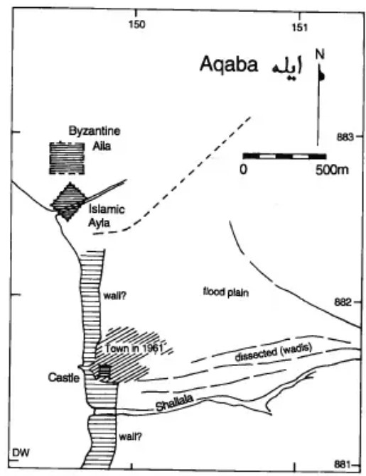 Figure 2
The succession of settlements at 'Aqaba, Jordan
Whitcomb (1997)
- Fig. 2.15 - Location Map
for Aqaba and environs from Allison (2013)
Figure 2.15
Map of archaeological sites in greater Aqaba, Jordan region (modified after Brückner et al. 2002).
Allison (2013)
- Ayla in Google Earth
 Ayla
Ayla
click on image to explore this site on a new tab in Google Earth
- Fig. 2 Plan of Islamic
Ayla from al-Tarazi and Khorjenkov (2007)
 Figure 2
Plan of the ancient city of Ayla with the locations of the measured stations (numbers inside boxes) described in the text. Hatched diagonal structure is a Wadi bed. BH is a borehole near the Egyptian gate (modified after Whitcomb 1993)
al-Tarazi and Khorjenkov (2007) - Fig. 1 Site Plan with Excavation
Areas of the Aqaba Archaeological Project from Damgaard and Jennings (2013)
 Figure 1
Phased plan of the archaeological site of Aylah. The new excavations are in the southwest quadrant
(© AAP)
Damgaard and Jennings (2013) - Fig. 2 Plan of Area IM
of the Aqaba Archaeological Project from Damgaard and Jennings (2013)
 Figure 2
Phased plan of excavation area in the southwest quadrant of Aylah
(© AAP)
Damgaard and Jennings (2013)
- Fig. 2 Plan of Islamic
Ayla from al-Tarazi and Khorjenkov (2007)
Figure 2
Plan of the ancient city of Ayla with the locations of the measured stations (numbers inside boxes) described in the text. Hatched diagonal structure is a Wadi bed. BH is a borehole near the Egyptian gate (modified after Whitcomb 1993)
al-Tarazi and Khorjenkov (2007) - Fig. 1 Site Plan with Excavation
Areas of the Aqaba Archaeological Project from Damgaard and Jennings (2013)
Figure 1
Phased plan of the archaeological site of Aylah. The new excavations are in the southwest quadrant
(© AAP)
Damgaard and Jennings (2013) - Fig. 2 Plan of Area IM
of the Aqaba Archaeological Project from Damgaard and Jennings (2013)
Figure 2
Phased plan of excavation area in the southwest quadrant of Aylah
(© AAP)
Damgaard and Jennings (2013)
- Fig. 5 - Photo of tilted
Sea Wall in Islamic Ayla from Niemi (2009)
 Fig. 5
Section of the Sea Wall [in Islamic Ayla], tilted outward and buttressed in antiquity, with reconstructed wall on original alignment in background, view to SE. from Whitcomb (1995)
Niemi (2009) - Fig. 4 - Displaced Wall
from Galli and Galadini (2001)
 Fig. 4
Map of Ayla according to Whitcomb(1994) (modifed). The western side of the town is affected by sinistral wrenching that displaces the southern wall and forces the northwestern wall to rotate counterclockwise (see inset photo).
JW: Rucker and Niemi (2005) trenched the site and found no evidence of this fault suggesting that the wall displacement shown is due to seismic forces perhaps aided by liquefaction.
Galli and Galadini (2001)
- Fig. 5 - Photo of tilted
Sea Wall in Islamic Ayla from Niemi (2009)
Fig. 5
Section of the Sea Wall [in Islamic Ayla], tilted outward and buttressed in antiquity, with reconstructed wall on original alignment in background, view to SE. from Whitcomb (1995)
Niemi (2009) - Fig. 4 - Displaced Wall
from Galli and Galadini (2001)
Fig. 4
Map of Ayla according to Whitcomb(1994) (modifed). The western side of the town is affected by sinistral wrenching that displaces the southern wall and forces the northwestern wall to rotate counterclockwise (see inset photo).
JW: Rucker and Niemi (2005) trenched the site and found no evidence of this fault suggesting that the wall displacement shown is due to seismic forces perhaps aided by liquefaction.
Galli and Galadini (2001)
- Fig. 2 Plan of Islamic
Ayla from al-Tarazi and Khorjenkov (2007)
Figure 2
Plan of the ancient city of Ayla with the locations of the measured stations (numbers inside boxes) described in the text. Hatched diagonal structure is a Wadi bed. BH is a borehole near the Egyptian gate (modified after Whitcomb 1993)
al-Tarazi and Khorjenkov (2007)
- Fig. 9 Negative profile
('Robber Trench') from Damgaard (2008)
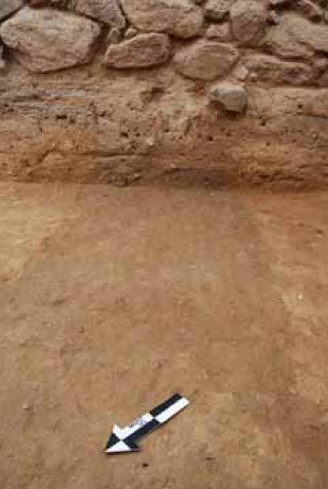 Figure 9
Negative of the early Abbasid wall (L77)
Damgaard (2008) - Fig. 10 Mud-brick collapse
from Damgaard (2008)
 Figure 10
Associated mud-brick collapse (L86)
Damgaard (2008)
- Fig. 2 Plan of Islamic
Ayla from al-Tarazi and Khorjenkov (2007)
Figure 2
Plan of the ancient city of Ayla with the locations of the measured stations (numbers inside boxes) described in the text. Hatched diagonal structure is a Wadi bed. BH is a borehole near the Egyptian gate (modified after Whitcomb 1993)
al-Tarazi and Khorjenkov (2007)
| Evidence type | Station | Location | Figure | Comments |
|---|---|---|---|---|
| Wall Repairs | 3 | near N corner of Ayla City Wall
Figure 2 Plan of the ancient city of Ayla with the locations of the measured stations (numbers inside boxes) described in the text. Hatched diagonal structure is a Wadi bed. BH is a borehole near the Egyptian gate (modified after Whitcomb 1993) al-Tarazi and Khorjenkov (2007) |
8
 Figure 8
Traces of poor quality repair in Ayla city wall to the NE from the city tower no. 4 (station no. 3) al-Tarazi and Khorjenkov (2007) |
poor quality repairs of the Ayla city wall- al-Tarazi and Khorjenkov (2007) |
| Wall Repairs | 6 | City quarter D
Figure 2 Plan of the ancient city of Ayla with the locations of the measured stations (numbers inside boxes) described in the text. Hatched diagonal structure is a Wadi bed. BH is a borehole near the Egyptian gate (modified after Whitcomb 1993) al-Tarazi and Khorjenkov (2007) |
9
 Figure 9
Mismatch of lower row of stones and upper wall fragments in city quarter D (station no. 6). There is a difference of 9° between the trends of two walls al-Tarazi and Khorjenkov (2007) |
clear mismatch between the lower row of stones and the upper wall fragment. The height of the lower row is 40 cm above the bottom of the excavated trench, where the height of the upper wall fragment is 160 cm. The azimuth of the lower row is 34°, while that of the upper wall fragment is 25° showing a difference of 9°.- al-Tarazi and Khorjenkov (2007) |
| Supporting Walls | 7 | City Quarter D
Figure 2 Plan of the ancient city of Ayla with the locations of the measured stations (numbers inside boxes) described in the text. Hatched diagonal structure is a Wadi bed. BH is a borehole near the Egyptian gate (modified after Whitcomb 1993) al-Tarazi and Khorjenkov (2007) |
10
 Figure 10
A wall perpendicular to the city wall (city Quarter D; station no. 7) has a supporting wall from its NE side. The last wall was built later in order to strengthen the original one that was tilted toward NE al-Tarazi and Khorjenkov (2007) |
Wall perpendicular to the city wall has a supporting wall on its NE side. The latter wall was built later in order to strengthen the original one that was tilted toward the NE. The height of the original wall is 300 cm above the bottom of the excavation trench has a declination azimuth of 41° and a tilt angle of 83°.- al-Tarazi and Khorjenkov (2007) |
| Supporting Walls | 21 | W corner of city wall
Figure 2 Plan of the ancient city of Ayla with the locations of the measured stations (numbers inside boxes) described in the text. Hatched diagonal structure is a Wadi bed. BH is a borehole near the Egyptian gate (modified after Whitcomb 1993) al-Tarazi and Khorjenkov (2007) |
4b
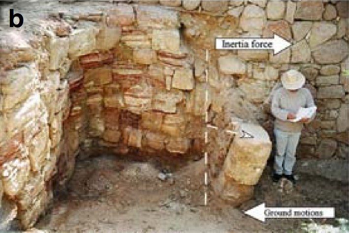 Figure 4b
Tilted walls in Ayla towards the SSW: (b) In seashore area (Station 21). Note the tilting of both the lower fragment of a column and a later built supporting wall. al-Tarazi and Khorjenkov (2007) |
|
| Secondary use of building materials in Early Abbasid buildings |
7 | City quarter D
Figure 2 Plan of the ancient city of Ayla with the locations of the measured stations (numbers inside boxes) described in the text. Hatched diagonal structure is a Wadi bed. BH is a borehole near the Egyptian gate (modified after Whitcomb 1993) al-Tarazi and Khorjenkov (2007) |
11a
 Figure 11a
Secondary use of building stones in Ayla. (a) A column drum built into the street wall in city quarter D (station no. 7). al-Tarazi and Khorjenkov (2007) |
column drum which is now inside of the street wall- al-Tarazi and Khorjenkov (2007) |
| Secondary use of building materials in Early Abbasid buildings |
13 | City quarter F
Figure 2 Plan of the ancient city of Ayla with the locations of the measured stations (numbers inside boxes) described in the text. Hatched diagonal structure is a Wadi bed. BH is a borehole near the Egyptian gate (modified after Whitcomb 1993) al-Tarazi and Khorjenkov (2007) |
11b
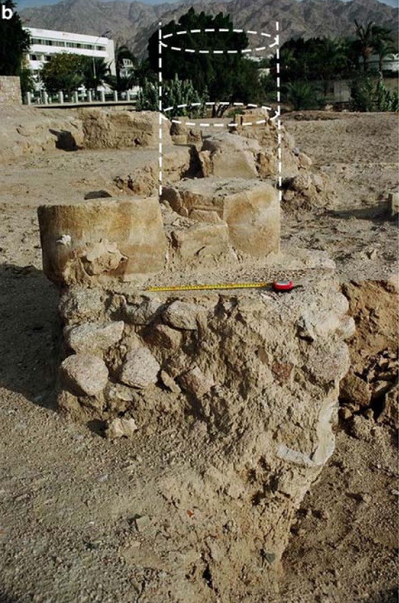 Figure 11b
Secondary use of building stones in Ayla. Two column drums at city quarter F (station no. 13): the right one belonged to the lower part of the column. It was probably damaged during the Umayyad earthquake. The left column drum was used later in order to support and reinforce the damaged column al-Tarazi and Khorjenkov (2007) |
two column drums belonging to a column likely damaged during the Umayyad earthquake. Another column drum (left in Fig. 11b) was later used in order to support the damaged column, while during the Fatimid earthquake, the column was finally destroyed and both drums were shifted out from their previous position.- al-Tarazi and Khorjenkov (2007) |
| Collapsed Walls | n/a | an east-west running wall perpendicular to a north-south running wall (L57/W13) in Area IM as defined by Damgaard (2008)
Figure 1 Phased plan of the archaeological site of Aylah. The new excavations are in the southwest quadrant (© AAP) Damgaard and Jennings (2013)
Figure 2Phased plan of excavation area in the southwest quadrant of Aylah (© AAP) Damgaard and Jennings (2013) |
Figure 9 Negative [aka Robber Trench] of the early Abbasid wall (L77) Damgaard (2008)
Figure 10Associated mud-brick collapse (L86) Damgaard (2008) |
the remnants of a wall [are] now gone [robber trench in Fig. 9] was confirmed by a patterned collapse of mud-brick (including a carbonised wooden beam) on its south side [Fig. 10]- Damgaard (2008) |
| Evidence type | Station | Plan | Figure | Comments |
|---|---|---|---|---|
| Systematic tilting of walls | 20 21 |
Figure 2 Plan of the ancient city of Ayla with the locations of the measured stations (numbers inside boxes) described in the text. Hatched diagonal structure is a Wadi bed. BH is a borehole near the Egyptian gate (modified after Whitcomb 1993) al-Tarazi and Khorjenkov (2007) |
4a
 Figure 4a
Tilted walls in Ayla towards the SSW (a) In a room of the Sea Gate building complex (Station 20) al-Tarazi and Khorjenkov (2007) 4b
Figure 4bTilted walls in Ayla towards the SSW (b) In seashore area (Station 21). Note the tilting of both the lower fragment of a column and a later built supporting wall. al-Tarazi and Khorjenkov (2007) 4c 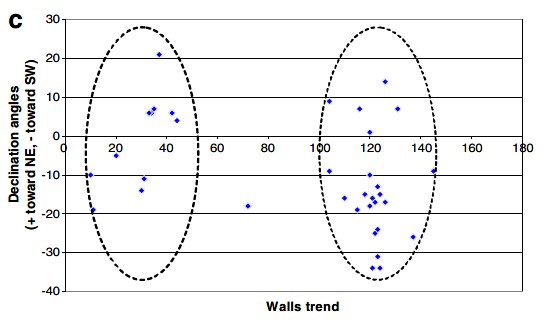 Figure 4c
Tilted walls in Ayla towards the SSW (c) Summary of measurements: direction of tilting patterns observed in Ayla as a function of the direction of the walls. ESE trending walls have systematic tilt toward SSW. al-Tarazi and Khorjenkov (2007) 4d  Figure 4d
Tilted walls in Ayla towards the SSW (d) Qualitative model showing the types of propagation of the seismic motions during the Nuweiba 1995 earthquake. Ayla was in the compression quadrangle and most of the walls oriented SE were tilted towards SW due to inertia al-Tarazi and Khorjenkov (2007) |
At Ayla, a wall in the southern room of the Sea Gate building complex K (Station 20 in Fig. 2 - Plan) is tilted toward SSW at an angle of up to 66° (in its central part) with a declination azimuth of 213° (Fig. 4a). Another example of the same damage pattern is in station 21 (in the western corner of the city wall), where a fragment of the wall is tilted at an angle of 72° with a declination angle of 210° (Fig. 4b).- al-Tarazi and Khorjenkov (2007) |
| Lateral shifting of building elements | 1 |
Figure 2 Plan of the ancient city of Ayla with the locations of the measured stations (numbers inside boxes) described in the text. Hatched diagonal structure is a Wadi bed. BH is a borehole near the Egyptian gate (modified after Whitcomb 1993) al-Tarazi and Khorjenkov (2007) |
5a
 Figure 5a
Shifting of wall fragments in Ayla: (a) Shift toward the SSW of the upper part of a wall attached and perpendicular to the city wall (station no. 1). al-Tarazi and Khorjenkov (2007) 5b  Figure 5b
Shifting of wall fragments in Ayla: (b) Summary of measurements: direction of shifting patterns observed in Ayla as a function of the direction of the walls. ESE trending walls have systematic shift toward SSW. al-Tarazi and Khorjenkov (2007) 5c  Figure 5c
Shifting of wall fragments in Ayla: (c) photograph and al-Tarazi and Khorjenkov (2007) 5d  Figure 5d
Shifting of wall fragments in Ayla: ( d) scheme. Shift toward the epicenter of the upper part of the grave monument during Suusamyr (1992, Ms = 7.3) earthquake in Kyrgyzstan al-Tarazi and Khorjenkov (2007) |
In Ayla, a 75 cm wide wall attached and perpendicular to a major city wall (station no. 1 — close to the northern corner of the city wall) has an original trend of 120°. Its upper part is shifted towards SSW (210°) of about 16 cm (Fig. 5a). The lower and undisturbed portion of the wall is 44 cm above the bottom of the excavation trench. The height of the preserved shifted fragment is 18 cm. The wall is composed of cemented sandstone and granite blocks.- al-Tarazi and Khorjenkov (2007) |
| Rotation of wall fragments around a vertical axis | 2 10 or 12 |
Figure 2 Plan of the ancient city of Ayla with the locations of the measured stations (numbers inside boxes) described in the text. Hatched diagonal structure is a Wadi bed. BH is a borehole near the Egyptian gate (modified after Whitcomb 1993) al-Tarazi and Khorjenkov (2007) |
6a
 Figure 6a
Rotations of the wall fragments in Ayla. (a) A counterclockwise rotation in the northwestern wall of the 4th city tower. The arrows point to a through-going joint (station no. 2). al-Tarazi and Khorjenkov (2007) 6b 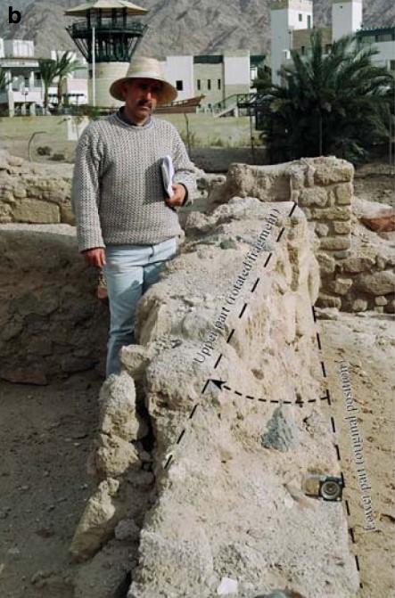 Figure 6b
Rotations of the wall fragments in Ayla. (b) Ayla city complex A: Upper part of the wall was rotated clockwise by 15° (station no. 10). al-Tarazi and Khorjenkov (2007) 6c 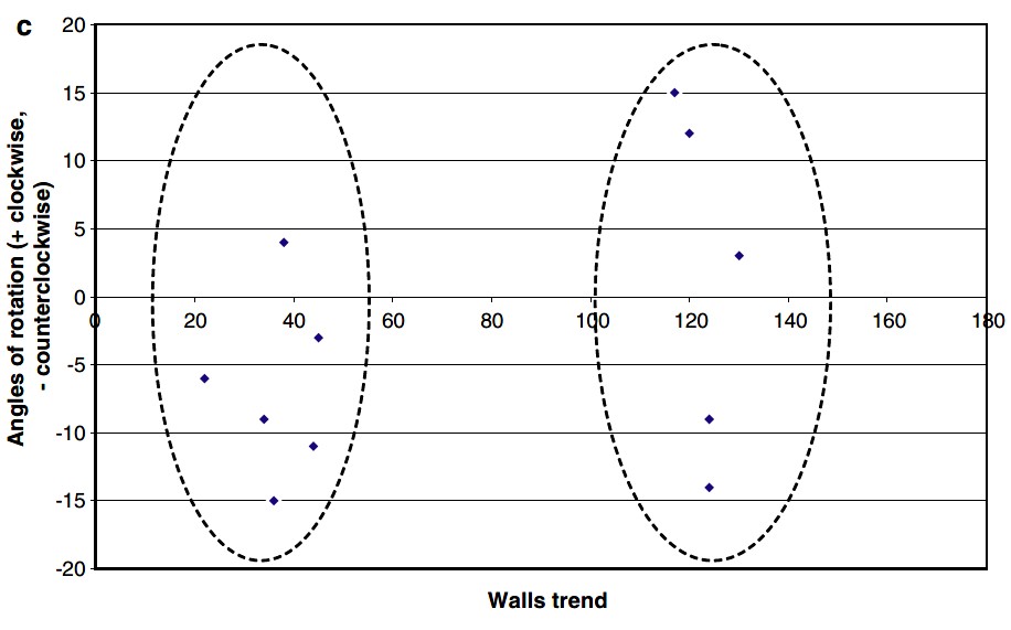 Figure 6c
Rotations of the wall fragments in Ayla. (c) Angle of rotation as a function of the wall trend: mostly counterclockwise rotations were observed in NNE walls and more clockwise rotations in ESE walls al-Tarazi and Khorjenkov (2007) |
In Ayla, there is a rotation pattern in the northwestern wall of the 4th city tower (station no. 2). The height of the remaining wall is 139 cm above the bottom of the excavation trench. The trend of the undisturbed wall is 124°, while the strike of the rotated wall fragment is 115°, this suggesting a counterclockwise rotation on 9° with maximum degree of rotation for the lower row of the wall (Fig. 6a). The maximum horizontal offset between two wall fragments is 8 cm.- al-Tarazi and Khorjenkov (2007) |
| Fractures across walls | 20 2 |
Figure 2 Plan of the ancient city of Ayla with the locations of the measured stations (numbers inside boxes) described in the text. Hatched diagonal structure is a Wadi bed. BH is a borehole near the Egyptian gate (modified after Whitcomb 1993) al-Tarazi and Khorjenkov (2007) |
7
 Figure 7
Tilted walls in Ayla towards the SSW (a) In a room of the Sea Gate building complex (Station 20) al-Tarazi and Khorjenkov (2007) 6a
Figure 6aRotations of the wall fragments in Ayla. (a) A counterclockwise rotation in the northwestern wall of the 4th city tower. The arrows point to a through-going joint (station no. 2). al-Tarazi and Khorjenkov (2007) |
Long through fissures cutting a whole wall are common phenomena among earthquake damage patterns (Stiros 1996; Korjenkov and Lemzin 2000). Several such patterns were also observed in Ayla. For example, a secondary wall attached and perpendicular to the main city wall (Station 3 in city Quarter E) was cut by a joint. The 55 cm long joint (left one in Fig. 7) crosses two stones of a 121° trending wall.- al-Tarazi and Khorjenkov (2007) |
- Modified by JW from Fig. 2 of al-Tarazi and Khorjenkov (2007) and Fig. 2 of Damgaard and Jennings (2013)
 Deformation Map
Modified by JW from Fig. 2 of al-Tarazi and Khorjenkov (2007) and Fig. 2 of Damgaard and Jennings (2013)
- Modified by JW from Fig. 2 of al-Tarazi and Khorjenkov (2007)
 Deformation Map
Modified by JW from Fig. 2 of al-Tarazi and Khorjenkov (2007)
- Fig. 4d Types of propagation
during the Nuweiba 1995 earthquake from al-Tarazi and Khorjenkov (2007)
Figure 4d
Qualitative model showing the types of propagation of the seismic motions during the Nuweiba 1995 earthquake. Ayla was in the compression quadrangle and most of the walls oriented SE were tilted towards SW due to inertia
al-Tarazi and Khorjenkov (2007)
A clear preference of southwest tilting is observed at the ruins of Ayla. Accordingly, the seismic shock likely arrived from the SW (Fig. 4d). As it is known the DST is a sinistral strike-slip fault and Ayla is located on the eastern block that moves northwards during strong earthquakes. Therefore, the building constructions are tilted to opposite direction because of inertia (Fig. 4d).
... Based on the above description of shifted building elements, the seismic shocks arrived from the SSW and the movements were transmitted from the ground to the building foundations, causing the upper wall fragments to move in an opposite direction due to inertia.
... The analysis of the clockwise and anticlockwise rotations supports a likely NNE-SSW direction of the seismic motion.
... Through-going joints are likely formed as a result of high intensity earthquake, while high energy is necessary to overcome the stress shadow of free surfaces at the stone margins (i.e., the free space between adjacent stones).
... The percentage of collapsed buildings of the Fatimid town can be well estimated as the ruins were left untouched. The survey disclosed that at least 15% of the well-built stone buildings of Fatimid Ayla collapsed and in practice no second floor structures survived with no severe damage. Again an EMS-98 intensity of IX or more is assumed.
- Earthquake Archeological Effects chart
of Rodríguez-Pascua et al (2013: 221-224)
 Earthquake Archeological Effects (EAE)
Rodríguez-Pascua et al (2013: 221-224)
| Effect | Location | Image(s) | Description | Intensity |
|---|---|---|---|---|
|
Ayla |
|
|
- Earthquake Archeological Effects chart
of Rodríguez-Pascua et al (2013: 221-224)
Earthquake Archeological Effects (EAE)
Rodríguez-Pascua et al (2013: 221-224)
| Effect | Location | Image(s) | Description | Intensity |
|---|---|---|---|---|
|
Ayla |
|
|
-
Earthquake Archeological Effects chart
of Rodríguez-Pascua et al (2013: 221-224)
Earthquake Archeological Effects (EAE)
Rodríguez-Pascua et al (2013: 221-224)
| Evidence type | Station | Location | Figure | Comments | Intensity |
|---|---|---|---|---|---|
| Displaced Walls indicated by Wall Repairs | 3 | near N corner of Ayla City Wall
Figure 2 Plan of the ancient city of Ayla with the locations of the measured stations (numbers inside boxes) described in the text. Hatched diagonal structure is a Wadi bed. BH is a borehole near the Egyptian gate (modified after Whitcomb 1993) al-Tarazi and Khorjenkov (2007) |
8
Figure 8 Traces of poor quality repair in Ayla city wall to the NE from the city tower no. 4 (station no. 3) al-Tarazi and Khorjenkov (2007) |
poor quality repairs of the Ayla city wall- al-Tarazi and Khorjenkov (2007) |
VII+ |
| Displaced Walls indicated by Wall Repairs | 6 | City quarter D
Figure 2 Plan of the ancient city of Ayla with the locations of the measured stations (numbers inside boxes) described in the text. Hatched diagonal structure is a Wadi bed. BH is a borehole near the Egyptian gate (modified after Whitcomb 1993) al-Tarazi and Khorjenkov (2007) |
9
Figure 9 Mismatch of lower row of stones and upper wall fragments in city quarter D (station no. 6). There is a difference of 9° between the trends of two walls al-Tarazi and Khorjenkov (2007) |
clear mismatch between the lower row of stones and the upper wall fragment. The height of the lower row is 40 cm above the bottom of the excavated trench, where the height of the upper wall fragment is 160 cm. The azimuth of the lower row is 34°, while that of the upper wall fragment is 25° showing a difference of 9°.- al-Tarazi and Khorjenkov (2007) |
VII+ |
| Tilted Walls indicated by Supporting Walls | 7 | City Quarter D
Figure 2 Plan of the ancient city of Ayla with the locations of the measured stations (numbers inside boxes) described in the text. Hatched diagonal structure is a Wadi bed. BH is a borehole near the Egyptian gate (modified after Whitcomb 1993) al-Tarazi and Khorjenkov (2007) |
10
Figure 10 A wall perpendicular to the city wall (city Quarter D; station no. 7) has a supporting wall from its NE side. The last wall was built later in order to strengthen the original one that was tilted toward NE al-Tarazi and Khorjenkov (2007) |
Wall perpendicular to the city wall has a supporting wall on its NE side. The latter wall was built later in order to strengthen the original one that was tilted toward the NE. The height of the original wall is 300 cm above the bottom of the excavation trench has a declination azimuth of 41° and a tilt angle of 83°.- al-Tarazi and Khorjenkov (2007) |
VI+ |
| Tilted Walls indicated by Supporting Walls | 21 | W corner of city wall
Figure 2 Plan of the ancient city of Ayla with the locations of the measured stations (numbers inside boxes) described in the text. Hatched diagonal structure is a Wadi bed. BH is a borehole near the Egyptian gate (modified after Whitcomb 1993) al-Tarazi and Khorjenkov (2007) |
4b
Figure 4b Tilted walls in Ayla towards the SSW: (b) In seashore area (Station 21). Note the tilting of both the lower fragment of a column and a later built supporting wall. al-Tarazi and Khorjenkov (2007) |
|
VI+ |
| Broken columns indicated by Secondary use of building materials in Early Abbasid buildings | 7 | City quarter D
Figure 2 Plan of the ancient city of Ayla with the locations of the measured stations (numbers inside boxes) described in the text. Hatched diagonal structure is a Wadi bed. BH is a borehole near the Egyptian gate (modified after Whitcomb 1993) al-Tarazi and Khorjenkov (2007) |
11a
Figure 11a Secondary use of building stones in Ayla. (a) A column drum built into the street wall in city quarter D (station no. 7). al-Tarazi and Khorjenkov (2007) |
column drum which is now inside of the street wall- al-Tarazi and Khorjenkov (2007) |
VI or VII + |
| Broken columns indicated by Secondary use of building materials in Early Abbasid buildings | 13 | City quarter F
Figure 2 Plan of the ancient city of Ayla with the locations of the measured stations (numbers inside boxes) described in the text. Hatched diagonal structure is a Wadi bed. BH is a borehole near the Egyptian gate (modified after Whitcomb 1993) al-Tarazi and Khorjenkov (2007) |
11b
Figure 11b Secondary use of building stones in Ayla. Two column drums at city quarter F (station no. 13): the right one belonged to the lower part of the column. It was probably damaged during the Umayyad earthquake. The left column drum was used later in order to support and reinforce the damaged column al-Tarazi and Khorjenkov (2007) |
two column drums belonging to a column likely damaged during the Umayyad earthquake. Another column drum (left in Fig. 11b) was later used in order to support the damaged column, while during the Fatimid earthquake, the column was finally destroyed and both drums were shifted out from their previous position.- al-Tarazi and Khorjenkov (2007) |
VI or VII + |
| Collapsed Walls | n/a | an east-west running wall perpendicular to a north-south running wall (L57/W13) in Area IM as defined by Damgaard (2008)
Figure 1 Phased plan of the archaeological site of Aylah. The new excavations are in the southwest quadrant (© AAP) Damgaard and Jennings (2013)
Figure 2Phased plan of excavation area in the southwest quadrant of Aylah (© AAP) Damgaard and Jennings (2013) |
Figure 9 Negative [aka Robber Trench] of the early Abbasid wall (L77) Damgaard (2008)
Figure 10Associated mud-brick collapse (L86) Damgaard (2008) |
the remnants of a wall [are] now gone [robber trench in Fig. 9] was confirmed by a patterned collapse of mud-brick (including a carbonised wooden beam) on its south side [Fig. 10]- Damgaard (2008) |
VIII + |
- Earthquake Archeological Effects chart
of Rodríguez-Pascua et al (2013: 221-224)
Earthquake Archeological Effects (EAE)
Rodríguez-Pascua et al (2013: 221-224)
| Evidence type | Station | Plan | Figure | Comments | Intensity |
|---|---|---|---|---|---|
| Systematic tilting of walls | 20 21 |
Figure 2 Plan of the ancient city of Ayla with the locations of the measured stations (numbers inside boxes) described in the text. Hatched diagonal structure is a Wadi bed. BH is a borehole near the Egyptian gate (modified after Whitcomb 1993) al-Tarazi and Khorjenkov (2007) |
4a
Figure 4a Tilted walls in Ayla towards the SSW (a) In a room of the Sea Gate building complex (Station 20) al-Tarazi and Khorjenkov (2007) 4b
Figure 4bTilted walls in Ayla towards the SSW (b) In seashore area (Station 21). Note the tilting of both the lower fragment of a column and a later built supporting wall. al-Tarazi and Khorjenkov (2007) 4c
Figure 4cTilted walls in Ayla towards the SSW (c) Summary of measurements: direction of tilting patterns observed in Ayla as a function of the direction of the walls. ESE trending walls have systematic tilt toward SSW. al-Tarazi and Khorjenkov (2007) 4d
Figure 4dTilted walls in Ayla towards the SSW (d) Qualitative model showing the types of propagation of the seismic motions during the Nuweiba 1995 earthquake. Ayla was in the compression quadrangle and most of the walls oriented SE were tilted towards SW due to inertia al-Tarazi and Khorjenkov (2007) |
At Ayla, a wall in the southern room of the Sea Gate building complex K (Station 20 in Fig. 2 - Plan) is tilted toward SSW at an angle of up to 66° (in its central part) with a declination azimuth of 213° (Fig. 4a). Another example of the same damage pattern is in station 21 (in the western corner of the city wall), where a fragment of the wall is tilted at an angle of 72° with a declination angle of 210° (Fig. 4b).- al-Tarazi and Khorjenkov (2007) |
VI+ |
| Lateral shifting of building elements | 1 |
Figure 2 Plan of the ancient city of Ayla with the locations of the measured stations (numbers inside boxes) described in the text. Hatched diagonal structure is a Wadi bed. BH is a borehole near the Egyptian gate (modified after Whitcomb 1993) al-Tarazi and Khorjenkov (2007) |
5a
Figure 5a Shifting of wall fragments in Ayla: (a) Shift toward the SSW of the upper part of a wall attached and perpendicular to the city wall (station no. 1). al-Tarazi and Khorjenkov (2007) 5b
Figure 5bShifting of wall fragments in Ayla: (b) Summary of measurements: direction of shifting patterns observed in Ayla as a function of the direction of the walls. ESE trending walls have systematic shift toward SSW. al-Tarazi and Khorjenkov (2007) 5c
Figure 5cShifting of wall fragments in Ayla: (c) photograph and al-Tarazi and Khorjenkov (2007) 5d
Figure 5dShifting of wall fragments in Ayla: ( d) scheme. Shift toward the epicenter of the upper part of the grave monument during Suusamyr (1992, Ms = 7.3) earthquake in Kyrgyzstan al-Tarazi and Khorjenkov (2007) |
In Ayla, a 75 cm wide wall attached and perpendicular to a major city wall (station no. 1 — close to the northern corner of the city wall) has an original trend of 120°. Its upper part is shifted towards SSW (210°) of about 16 cm (Fig. 5a). The lower and undisturbed portion of the wall is 44 cm above the bottom of the excavation trench. The height of the preserved shifted fragment is 18 cm. The wall is composed of cemented sandstone and granite blocks.- al-Tarazi and Khorjenkov (2007) |
VIII+ |
| Rotation of wall fragments around a vertical axis | 2 10 or 12 |
Figure 2 Plan of the ancient city of Ayla with the locations of the measured stations (numbers inside boxes) described in the text. Hatched diagonal structure is a Wadi bed. BH is a borehole near the Egyptian gate (modified after Whitcomb 1993) al-Tarazi and Khorjenkov (2007) |
6a
Figure 6a Rotations of the wall fragments in Ayla. (a) A counterclockwise rotation in the northwestern wall of the 4th city tower. The arrows point to a through-going joint (station no. 2). al-Tarazi and Khorjenkov (2007) 6b
Figure 6bRotations of the wall fragments in Ayla. (b) Ayla city complex A: Upper part of the wall was rotated clockwise by 15° (station no. 10). al-Tarazi and Khorjenkov (2007) 6c
Figure 6cRotations of the wall fragments in Ayla. (c) Angle of rotation as a function of the wall trend: mostly counterclockwise rotations were observed in NNE walls and more clockwise rotations in ESE walls al-Tarazi and Khorjenkov (2007) |
In Ayla, there is a rotation pattern in the northwestern wall of the 4th city tower (station no. 2). The height of the remaining wall is 139 cm above the bottom of the excavation trench. The trend of the undisturbed wall is 124°, while the strike of the rotated wall fragment is 115°, this suggesting a counterclockwise rotation on 9° with maximum degree of rotation for the lower row of the wall (Fig. 6a). The maximum horizontal offset between two wall fragments is 8 cm.- al-Tarazi and Khorjenkov (2007) |
VIII+ |
| Fractures across walls | 20 2 |
Figure 2 Plan of the ancient city of Ayla with the locations of the measured stations (numbers inside boxes) described in the text. Hatched diagonal structure is a Wadi bed. BH is a borehole near the Egyptian gate (modified after Whitcomb 1993) al-Tarazi and Khorjenkov (2007) |
7
Figure 7 Tilted walls in Ayla towards the SSW (a) In a room of the Sea Gate building complex (Station 20) al-Tarazi and Khorjenkov (2007) 6a
Figure 6aRotations of the wall fragments in Ayla. (a) A counterclockwise rotation in the northwestern wall of the 4th city tower. The arrows point to a through-going joint (station no. 2). al-Tarazi and Khorjenkov (2007) |
Long through fissures cutting a whole wall are common phenomena among earthquake damage patterns (Stiros 1996; Korjenkov and Lemzin 2000). Several such patterns were also observed in Ayla. For example, a secondary wall attached and perpendicular to the main city wall (Station 3 in city Quarter E) was cut by a joint. The 55 cm long joint (left one in Fig. 7) crosses two stones of a 121° trending wall.- al-Tarazi and Khorjenkov (2007) |
VI+ |