Dharih
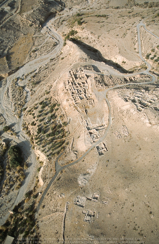
APAAME
- Reference: APAAME_20020930_DLK-0254.tif
- Photographer: ?
- Credit: Aerial Photographic Archive for Archaeology in the Middle East
- Copyright: Creative Commons Attribution-Noncommercial-No Derivative Works
| Transliterated Name | Source | Name |
|---|---|---|
| Dharih | Arabic | |
| Khirbet ed-Dharih | Arabic | خربة الذريح |
- Dharih in Google Earth
 Dharih
click on image to explore this site on a new tab in Google Earth
- Fig. 1 Site plan from
Durand (2015)
 Figure 1
General plan of the site of Dharih
J. Humbert, 2004
Durand (2015)
- Fig. 1 Site plan from
Durand (2015)
Figure 1
General plan of the site of Dharih
J. Humbert, 2004
Durand (2015)
- Fig. 2 Quarter A from
Durand (2015)
 Figure 2
Dharih, map of neighborhood A
JW: Bains = Baths
J. Humbert, 2004
Durand (2015) - Fig. 10 Area A plan
from Durand et al. (2018)
 Figure 10
Plan of Area A. The mansio and the bath-complex. Grey sections indicate areas investigated during the 2013 season
(© J. Humbert 2004)
Durand et al. (2018) - Fig. 3 A2 baths from
Durand (2015)
 Figure 3
Dharih, plan of the A2 baths
JW: Bains = Baths
J. Humbert, 2004, C. Durand, 2014, and supplements Th. Fournet, 2015
Durand (2015)
- Fig. 2 Quarter A from
Durand (2015)
Figure 2
Dharih, map of neighborhood A
JW: Bains = Baths
J. Humbert, 2004
Durand (2015) - Fig. 10 Area A plan
from Durand et al. (2018)
Figure 10
Plan of Area A. The mansio and the bath-complex. Grey sections indicate areas investigated during the 2013 season
(© J. Humbert 2004)
Durand et al. (2018) - Fig. 3 A2 baths from
Durand (2015)
Figure 3
Dharih, plan of the A2 baths
JW: Bains = Baths
J. Humbert, 2004, C. Durand, 2014, and supplements Th. Fournet, 2015
Durand (2015)
- Fig. 2 Map/Plan of the
sanctuary and surroundings from Al-Muheisen and Villeneuve (2000)
 Figure 2
Map/Plan of the area where the sanctuary is located, the building called “rectangular foundation” and the main house VI
(J. Humbert, A. Oman)
Al-Muheisen and Villeneuve (2000) - Fig. 7 Plan of the
sanctuary from the 2nd to the 4th century CE from Al-Muheisen and Villeneuve (2000)
 Figure 7
General plan of the sanctuary, from the 2nd to the 4th century AD
(J. Humbert etal.)
Al-Muheisen and Villeneuve (2000) - Fig. 9 Plan of the
northern courtyard of the sanctuary, with the temple from the 2nd to the 4th century CE from Al-Muheisen and Villeneuve (2000)
 Figure 9
Plan of the northern courtyard of the sanctuary, with the temple, from the 2nd to the 4th century AD.
(J. Humbert etal.)
Al-Muheisen and Villeneuve (2000) - Fig. 20 Plan of the
Christian settlement in the 6th and 7th centuries CE from Al-Muheisen and Villeneuve (2000)
 Figure 20
Plan of the Christian settlement, with the cella of the temple transformed into a church, state in the 6th and 7th centuries AD.
(J. Humbert etal.)
Al-Muheisen and Villeneuve (2000) - Fig. 21 Plan of the
Islamic settlement around the middle of the 8th century CE from Al-Muheisen and Villeneuve (2000)
 Figure 21
Plan of the Islamic settlement, around the middle of the 8th century AD.
(J. Humbert etal.)
Al-Muheisen and Villeneuve (2000)
- Fig. 2 Map/Plan of the
sanctuary and surroundings from Al-Muheisen and Villeneuve (2000)
Figure 2
Map/Plan of the area where the sanctuary is located, the building called “rectangular foundation” and the main house VI
(J. Humbert, A. Oman)
Al-Muheisen and Villeneuve (2000) - Fig. 7 Plan of the
sanctuary from the 2nd to the 4th century CE from Al-Muheisen and Villeneuve (2000)
Figure 7
General plan of the sanctuary, from the 2nd to the 4th century AD
(J. Humbert etal.)
Al-Muheisen and Villeneuve (2000) - Fig. 9 Plan of the
northern courtyard of the sanctuary, with the temple from the 2nd to the 4th century CE from Al-Muheisen and Villeneuve (2000)
Figure 9
Plan of the northern courtyard of the sanctuary, with the temple, from the 2nd to the 4th century AD.
(J. Humbert etal.)
Al-Muheisen and Villeneuve (2000) - Fig. 20 Plan of the
Christian settlement in the 6th and 7th centuries CE from Al-Muheisen and Villeneuve (2000)
Figure 20
Plan of the Christian settlement, with the cella of the temple transformed into a church, state in the 6th and 7th centuries AD.
(J. Humbert etal.)
Al-Muheisen and Villeneuve (2000) - Fig. 21 Plan of the
Islamic settlement around the middle of the 8th century CE from Al-Muheisen and Villeneuve (2000)
Figure 21
Plan of the Islamic settlement, around the middle of the 8th century AD.
(J. Humbert etal.)
Al-Muheisen and Villeneuve (2000)
- Fig. 2 Plan of House V1
from Durand et al. (2018)
 Figure 2
Plan of House V1. Grey sections indicate areas investigated during the 2013 season
(© P. P.-F. 2013)
Durand et al. (2018)
- Fig. 2 Plan of House V1
from Durand et al. (2018)
Figure 2
Plan of House V1. Grey sections indicate areas investigated during the 2013 season
(© P. P.-F. 2013)
Durand et al. (2018)
- Tilted upper wall stones
from ACOR
 JW: Tilted upper wall stones in the front left
Click on Photo to see the photo and metadata in a new tab on the ACOR Website
Rami Khouri collection 1983-1987 ACOR.
| Effect | Location | Image | Description |
|---|---|---|---|
|
House (Maison) V1
Figure 1 General plan of the site of Dharih J. Humbert, 2004 Durand (2015)
Figure 2Plan of House V1. Grey sections indicate areas investigated during the 2013 season (© P. P.-F. 2013) Durand et al. (2018) |
|
|
|
Western half of open space/courtyard A12 in Area A (Quartier A)
Figure 1 General plan of the site of Dharih J. Humbert, 2004 Durand (2015)
Figure 10Plan of Area A. The mansio and the bath-complex. Grey sections indicate areas investigated during the 2013 season (© J. Humbert 2004) Durand et al. (2018) |
|
| Effect | Location | Image | Description |
|---|---|---|---|
|
Temple
Figure 1 General plan of the site of Dharih J. Humbert, 2004 Durand (2015)
Figure 2Map/Plan of the area where the sanctuary is located, the building called “rectangular foundation” and the main house VI (J. Humbert, A. Oman) Al-Muheisen and Villeneuve (2000)
Figure 21Plan of the Islamic settlement, around the middle of the 8th century AD. (J. Humbert etal.) Al-Muheisen and Villeneuve (2000) |
|
-
Earthquake Archeological Effects chart
of Rodríguez-Pascua et al (2013: 221-224)
 Earthquake Archeological Effects (EAE)
Rodríguez-Pascua et al (2013: 221-224)
| Effect | Location | Image | Description | Intensity |
|---|---|---|---|---|
|
House (Maison) V1
Figure 1 General plan of the site of Dharih J. Humbert, 2004 Durand (2015)
Figure 2Plan of House V1. Grey sections indicate areas investigated during the 2013 season (© P. P.-F. 2013) Durand et al. (2018) |
|
|
|
|
Western half of open space/courtyard A12 in Area A (Quartier A)
Figure 1 General plan of the site of Dharih J. Humbert, 2004 Durand (2015)
Figure 10Plan of Area A. The mansio and the bath-complex. Grey sections indicate areas investigated during the 2013 season (© J. Humbert 2004) Durand et al. (2018) |
|
|
-
Earthquake Archeological Effects chart
of Rodríguez-Pascua et al (2013: 221-224)
Earthquake Archeological Effects (EAE)
Rodríguez-Pascua et al (2013: 221-224)
| Effect | Location | Image | Description | Intensity |
|---|---|---|---|---|
|
Temple
Figure 1 General plan of the site of Dharih J. Humbert, 2004 Durand (2015)
Figure 2Map/Plan of the area where the sanctuary is located, the building called “rectangular foundation” and the main house VI (J. Humbert, A. Oman) Al-Muheisen and Villeneuve (2000)
Figure 21Plan of the Islamic settlement, around the middle of the 8th century AD. (J. Humbert etal.) Al-Muheisen and Villeneuve (2000) |
|
|