Umm al Qanatir
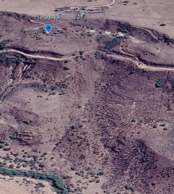 Umm al Qanatir
Landslide Scar to the right is annotated in the Landslide Maps section
click on image to explore this site on a new tab in Google Earth
| Transliterated Name | Language | Name |
|---|---|---|
| Umm el-Qanatir | Arabic | ام القناطر |
| Umm el-Kanatir | Arabic | ام القناطر |
| Ein Keshatot | Hebrew | |
| Rehavam's Arches | ||
| Kantur | ||
| Qamtra |
- Umm al Qanatir in Google Earth
 Umm al Qanatir
click on image to explore this site on a new tab in Google Earth - Umm al Qanatir on govmap.gov.il
 Umm al Qanatir
click on image to explore this site on a new tab in govmap.gov.il - Aerial View of Umm al-Qanatir
synagogue from Wikipedia
 Umm el-Qanatir synagogue from the air (2013)
click on image to open a high res magnifiable image in a new tab
Avram Gracier - Wikipedia - CC BY-SA 3.0

- Umm al Qanatir in Google Earth
Umm al Qanatir
click on image to explore this site on a new tab in Google Earth - Umm al Qanatir on govmap.gov.il
Umm al Qanatir
click on image to explore this site on a new tab in govmap.gov.il - Aerial View of Umm al-Qanatir
synagogue from Wikipedia
Umm el-Qanatir synagogue from the air (2013)
click on image to open a high res magnifiable image in a new tab
Avram Gracier - Wikipedia - CC BY-SA 3.0
- Fig. 4 Plan of the synagogue
at Umm al-Qanatir from Dray et al. (2017)
 Fig. 4
Schematic plan; last phase of the building shown in red
Dray et al. (2017) - Fig. 1 Images of the three
upper layers of the collapsed structure of the synagogue at Umm al-Qanatir from Dray et al. (2017)
 Fig. 1
Computer imaging of 3D mapping: three upper layers of the collapsed structure of the synagogue
Dray et al. (2017)
- Fig. 4 Plan of the synagogue
at Umm al-Qanatir from Dray et al. (2017)
Fig. 4
Schematic plan; last phase of the building shown in red
Dray et al. (2017) - Fig. 1 Images of the three
upper layers of the collapsed structure of the synagogue at Umm al-Qanatir from Dray et al. (2017)
Fig. 1
Computer imaging of 3D mapping: three upper layers of the collapsed structure of the synagogue
Dray et al. (2017)
- Fig. 2a Overhead Aerial photo of
landslide from Wechsler et al (2008)
 Fig. 2a
Aerial photo of study area.
Wechsler et al (2008) - Fig. 2a Ground-based Photo of
landslide looking north from Wechsler et al (2008)
 Fig. 2b
A northward look at the Umm-El-Qanatir site.
Wechsler et al (2008)
- Fig. 2a Overhead Aerial photo of
landslide from Wechsler et al (2008)
Fig. 2a
Aerial photo of study area.
Wechsler et al (2008) - Fig. 2a Ground-based Photo of
landslide looking north from Wechsler et al (2008)
Fig. 2b
A northward look at the Umm-El-Qanatir site.
Wechsler et al (2008)
- Fig. 2 Collapsed elements
on the synagogue floor and the column bases in situ from Dray et al. (2017)
 Fig. 2
Collapsed elements on the synagogue floor and the column bases in situ (view to the north)
Dray et al. (2017) - Fig. 3 Collapsed eastern
wall from Dray et al. (2017)
 Fig. 3
The collapsed eastern wall (view to the south)
Dray et al. (2017) - Fig. 9 Secondary construction
of rooms in the northern part of the synagogue from Dray et al. (2017)
 Fig. 9
Secondary construction of rooms in the northern part of the synagogue (view to the south)
Dray et al. (2017) - Fig. 5 Secondary construction
of rooms in the northern part of the synagogue from Wechsler et al (2008)
 Fig. 5
The synagogue suffered two damaging events. The firs led to its abandonment, as evidenced by a makeshift house (marked with dashed line), which was built on the floor of the synagogue using many of its finely carved stones. The second event caused the destruction of this house and triggered the abandonment of the whole site, as evidenced by absence of post mid-8th century artifacts
Wechsler et al (2008) - Fig. 4a Horizontal shift of
large masonry basalt blocks of the synagogue wall from Wechsler et al (2008)
 Fig. 4a
Horizontal shift of a large masonry basalt blocks at the synagogue wall
Wechsler et al (2008) - Fig. 4b Horizontal shift of
large masonry basalt blocks of the synagogue wall from Wechsler et al (2008)
 Fig. 4b
Horizontal shift of a large masonry basalt blocks at the synagogue wall
Wechsler et al (2008) - Fig. 4c Slipped arch voussoir
(possibly a keystone) from Wechsler et al (2008)
 Fig. 4c
Keystones of an arch that slid out.
Wechsler et al (2008) - Fig. 4d Aligned fallen columns
from Wechsler et al (2008)
 Fig. 4d
Aligned fallen columns
Wechsler et al (2008) - Fig. 4e Westward collapse of
a wall of the synagogue from Wechsler et al (2008)
 Fig. 4e
Westward collapse of the wall of the synagogue
Wechsler et al (2008) - Fig. 4f Sheared water pool
of the Spring complex from Wechsler et al (2008)
 Fig. 4f
A water pool, part of the spring complex, displaced left- laterally 95 cm. This water pool is displaced by the landslide and is used for the slope stability analysis
Wechsler et al (2008) - Plate XIXa Arch built over
spring from Sukenik (1935)
 Plate XIXa
Umm el Qanatir: Arch built over spring
Sukenik (1935) - Plate XIXb Ruins of Synagogue
from Sukenik (1935)
 Plate XIXb
Umm el Qanatir: View of ruins of Synagogue
Sukenik (1935)
- Fig. 2 Collapsed elements
on the synagogue floor and the column bases in situ from Dray et al. (2017)
Fig. 2
Collapsed elements on the synagogue floor and the column bases in situ (view to the north)
Dray et al. (2017) - Fig. 3 Collapsed eastern
wall from Dray et al. (2017)
Fig. 3
The collapsed eastern wall (view to the south)
Dray et al. (2017) - Fig. 9 Secondary construction
of rooms in the northern part of the synagogue from Dray et al. (2017)
Fig. 9
Secondary construction of rooms in the northern part of the synagogue (view to the south)
Dray et al. (2017) - Fig. 5 Secondary construction
of rooms in the northern part of the synagogue from Wechsler et al (2008)
Fig. 5
The synagogue suffered two damaging events. The firs led to its abandonment, as evidenced by a makeshift house (marked with dashed line), which was built on the floor of the synagogue using many of its finely carved stones. The second event caused the destruction of this house and triggered the abandonment of the whole site, as evidenced by absence of post mid-8th century artifacts
Wechsler et al (2008) - Fig. 4a Horizontal shift of
large masonry basalt blocks of the synagogue wall from Wechsler et al (2008)
Fig. 4a
Horizontal shift of a large masonry basalt blocks at the synagogue wall
Wechsler et al (2008) - Fig. 4b Horizontal shift of
large masonry basalt blocks of the synagogue wall from Wechsler et al (2008)
Fig. 4b
Horizontal shift of a large masonry basalt blocks at the synagogue wall
Wechsler et al (2008) - Fig. 4c Slipped arch voussoir
(possibly a keystone) from Wechsler et al (2008)
Fig. 4c
Keystones of an arch that slid out.
Wechsler et al (2008) - Fig. 4d Aligned fallen columns
from Wechsler et al (2008)
Fig. 4d
Aligned fallen columns
Wechsler et al (2008) - Fig. 4e Westward collapse of
a wall of the synagogue from Wechsler et al (2008)
Fig. 4e
Westward collapse of the wall of the synagogue
Wechsler et al (2008) - Fig. 4f Sheared water pool
of the Spring complex from Wechsler et al (2008)
Fig. 4f
A water pool, part of the spring complex, displaced left- laterally 95 cm. This water pool is displaced by the landslide and is used for the slope stability analysis
Wechsler et al (2008) - Plate XIXa Arch built over
spring from Sukenik (1935)
Plate XIXa
Umm el Qanatir: Arch built over spring
Sukenik (1935) - Plate XIXb Ruins of Synagogue
from Sukenik (1935)
Plate XIXb
Umm el Qanatir: View of ruins of Synagogue
Sukenik (1935)
- Fig. 4f Sheared water pool
of the Spring complex from Wechsler et al (2008)
Fig. 4f
A water pool, part of the spring complex, displaced left- laterally 95 cm. This water pool is displaced by the landslide and is used for the slope stability analysis
Wechsler et al (2008)
- Fig. 9 Secondary construction
of rooms in the northern part of the synagogue from Dray et al. (2017)
Fig. 9
Secondary construction of rooms in the northern part of the synagogue (view to the south)
Dray et al. (2017) - Fig. 5 Secondary construction
of rooms in the northern part of the synagogue from Wechsler et al (2008)
Fig. 5
The synagogue suffered two damaging events. The firs led to its abandonment, as evidenced by a makeshift house (marked with dashed line), which was built on the floor of the synagogue using many of its finely carved stones. The second event caused the destruction of this house and triggered the abandonment of the whole site, as evidenced by absence of post mid-8th century artifacts
Wechsler et al (2008) - Fig. 4 Plan of the synagogue
at Umm al-Qanatir from Dray et al. (2017)
Fig. 4
Schematic plan; last phase of the building shown in red
Dray et al. (2017) - Fig. 1 Images of the three
upper layers of the collapsed structure of the synagogue at Umm al-Qanatir from Dray et al. (2017)
Fig. 1
Computer imaging of 3D mapping: three upper layers of the collapsed structure of the synagogue
Dray et al. (2017)
The Last Phase of the Building
The above-mentioned remains of secondary construction found inside the synagogue abutted the entire length of its northern wall (W1036), utilizing architectural elements from the upper part of the building, such as bases, capitals, engaged columns and cornices, and creating four rooms (fig. 9). The rest of the interior was found devoid of fragments of benches or roof tiles. Immediately to the south of these rooms, along W1071, three capitals and bases were found in a row. Along the western wall (W1062), immediately to the north of the western doorway, three adjacent stretchers were uncovered. Along the benches in the east (L1080), at the point of ascent to the eastern doorway from the earlier phase, two doorpost stones and a threshold stone were found next to one another.
The four rooms (fig. 4) extended over an area of 68 m2 (all rectangular, L1240: 2.40 × 5.50 m; L1241: 2.50 × 6.60 m; L1242: 2.00 × 5.80 m; and L1243: 2.50 × 5.20 m). One interior wall (W1065) is fenestrated, found in a ‘domino collapse’ arrangement. Significantly, when W1063 was dismantled, two architectural elements in secondary use were found to have been used in its construction. The faces of these elements, which bore reliefs, had been set toward the interior and were thus not visible. One was the base of an engaged column decorated with a double meander and an animal; the other was the capital of an engaged column bearing a seven-branched menorah, shofars, a bird holding a ring in its beak and a double meander.
Under the collapse, in the fill of the rooms, which consisted mainly of light-coloured clayish soil, a variety of items were found, including basalt rollers, mortars and a quern (jarusha), as well as an assemblage of iron agricultural tools such as pick-axes, double-axes, sickles, a knife, a pruning hook, a mattock and the components of a complete disk-thresher. The fill of room L1240 revealed an assemblage of complete pottery vessels, including an intact juglet and a cooking-pot lid on top of a jug inside a cooking bowl, within which another intact juglet was found. These vessels are dated to the first half of the eighth century CE (fig. 10).
Outside the synagogue’s western doorway an improvised staircase (L1118) was found, consisting of architectural elements in secondary use, such as a rounded cornice stone. Alongside the steps to the north, three column shafts were laid side by side, while alongside the steps on the south, two beams were set one on top of the other. The upper beam had a broken end, and the lower one bears a geometric and vegetal relief at the narrow side.
The eastern wall of the building from this phase was built without doorways. Four additional courses were laid above the original ‘header course’ –– which was set obliquely, low in the south and rising toward the north, 0.27–0.53 m above the benches. The stones in these courses were of various sizes in secondary use. They were carelessly laid, with their carved face even set toward the interior. The wall from this phase was preserved to a height of 2.00 m above the floor.
Meagre remains found outside the synagogue made use of architectural elements from the upper parts of the building, including cornices and capitals: about 5 m east of the synagogue, the foundations of two rooms can be seen above the collapsed eastern wall, while next to the southeastern corner of the synagogue and atop its southern portico, remains were found of additional walls, too poorly preserved for their nature to be discerned.
| Effect | Location | Image(s) | Description |
|---|---|---|---|
| Displaced masonry blocks | entrance pier and southern wall of the synagogue
Fig. 4 Schematic plan; last phase of the building shown in red Dray et al. (2017) |
Fig. 4a Horizontal shift of a large masonry basalt blocks at the synagogue wall Wechsler et al (2008)
Fig. 4bHorizontal shift of a large masonry basalt blocks at the synagogue wall Wechsler et al (2008) |
|
| Collapsed Walls | western wall (W1062) of the synagogue
Fig. 4 Schematic plan; last phase of the building shown in red Dray et al. (2017) |
Fig. 4e Westward collapse of the wall of the synagogue Wechsler et al (2008) |
|
| Collapsed Walls | eastern wall (W1024) of the synagogue
Fig. 4 Schematic plan; last phase of the building shown in red Dray et al. (2017) |
Fig. 3 The collapsed eastern wall (view to the south) Dray et al. (2017) |
|
| Fallen columns | synagogue interior
Fig. 4 Schematic plan; last phase of the building shown in red Dray et al. (2017) |
Fig. 4d Aligned fallen columns Wechsler et al (2008)
Fig. 2Collapsed elements on the synagogue floor and the column bases in situ (view to the north) Dray et al. (2017) |
|
| Sheared Water Pool | Pool in Spring Complex
Fig. 2a Aerial photo of study area. Wechsler et al (2008) |
Fig. 4f A water pool, part of the spring complex, displaced left- laterally 95 cm. This water pool is displaced by the landslide and is used for the slope stability analysis Wechsler et al (2008) |
|
| Landslide | downslope from the synagogue |
Fig. 2a Aerial photo of study area. Wechsler et al (2008)
Fig. 2bA northward look at the Umm-El-Qanatir site. Wechsler et al (2008) |
|
| Re-used building elements | secondary structure (aka makeshift house) inside the synagogue along with other areas in the synagogue and outside the synagogue
Fig. 4 Schematic plan; last phase of the building shown in red Dray et al. (2017)
Fig. 9Secondary construction of rooms in the northern part of the synagogue (view to the south) Dray et al. (2017)
Fig. 5The synagogue suffered two damaging events. The firs led to its abandonment, as evidenced by a makeshift house (marked with dashed line), which was built on the floor of the synagogue using many of its finely carved stones. The second event caused the destruction of this house and triggered the abandonment of the whole site, as evidenced by absence of post mid-8th century artifacts Wechsler et al (2008) |
|
| Effect | Location | Image(s) | Description |
|---|---|---|---|
| Collapsed Walls | makeshift house inside synagogue
Fig. 4 Schematic plan; last phase of the building shown in red Dray et al. (2017)
Fig. 5The synagogue suffered two damaging events. The firs led to its abandonment, as evidenced by a makeshift house (marked with dashed line), which was built on the floor of the synagogue using many of its finely carved stones. The second event caused the destruction of this house and triggered the abandonment of the whole site, as evidenced by absence of post mid-8th century artifacts Wechsler et al (2008)
Fig. 9Secondary construction of rooms in the northern part of the synagogue (view to the south) Dray et al. (2017) |
|
|
| Collapsed Wall | Wall W1065 in the secondary structure
Fig. 4 Schematic plan; last phase of the building shown in red Dray et al. (2017)
Fig. 9Secondary construction of rooms in the northern part of the synagogue (view to the south) Dray et al. (2017)
Fig. 5The synagogue suffered two damaging events. The firs led to its abandonment, as evidenced by a makeshift house (marked with dashed line), which was built on the floor of the synagogue using many of its finely carved stones. The second event caused the destruction of this house and triggered the abandonment of the whole site, as evidenced by absence of post mid-8th century artifacts Wechsler et al (2008) |
|
- Modified by JW from Fig. 4 of Dray et al. (2017)
 Deformation Map
lightly modified by JW from Fig. 4 of Dray et al. (2017)
- Modified by JW from Google Earth capture
 Landslide Map
Modified by JW from Google Earth capture
2 D Model
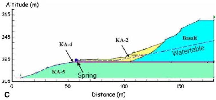 Fig. 2c - Cross section showing geological units and sample numbers. Water table is assumed.
This section is used to model slope stability ...
Fig. 2c - Cross section showing geological units and sample numbers. Water table is assumed.
This section is used to model slope stability ... Wechsler et al (2008)
Soil Properties
Cohesion (C) and the Angle of Internal friction (Φ) was determined for all three soil units (KA-2, KA-4, and KA-5) via a direct shear test performed under an undrained consolidated setting. KA-4, a red clay paleosoil which is believed to have been the layer responsible for the slope failure during the landslide yielded values of C = 4.0 kN/m and Φ = 31º. The other soils had similar friction angles and roughly five times higher higher cohesion (C).Static Analysis
A Factor of Safety (FS) for the slope was estimated first to determine if the slope was stable under aseismic conditions. Two methods were used - the Fellenius method and the modified Bishop method. Both methods divide the soil model into vertical slices and determine Factor of Safety as a ratio from a sum of moment balances performed on each vertical slice. This accounts for changes in topography and lateral changes in unit thicknesses and elevation of the water table. The generalized equation is shown below.FS = Σ Mr / Σ Md
where
Mr = Resisting Moment
Md = Driving Moment
Resisting Moment is the ability of the soil mass to avoid moving. The driving moment is the forces such as gravity and water saturated layers pushing the soil mass down slope. FS less than 1 indicates that the slope is unstable. FS greater than 1 indicates that the slope is stable. Wechsler et al (2008) evaluated FS for a variety of conditions using both the Fellenius and modified Bishop method and came up with a range of FS values from 2.05 to 3.23 - indicating that the slope is aseismically stable. The lowest value of FS represents a condition where the water table comes right up to the surface. The highest value of FS corresponds to a condition where the water table was at the same elevation as the impermeable soil unit KA-4. Wechsler et al (2008) noted that
the existence of the year-round flowing spring (and several others in the vicinity) indicates a high water table, and the weather patterns (rainy winter with ~900 mm average annual rainfall) suggest that at times it can be as high as the topography.Thus, lower values of FS may represent realistic conditions for the slope. The commercial software Slope/W™ was used to perform the Static Analysis. Modeling indicated that slope stability was largely determined by the weakest layer (lowest Cohesion) - paleosoil KA-4.
Dynamic Analysis
The Newmark Displacement method was used to evaluate slope stability during an earthquake. First a critical acceleration was estimated. Critical acceleration is the minimum earthquake induced acceleration that initiates slope movement. Critical acceleration was computed as follows:ac = (FS-1)sinβ
where
ac = critical acceleration measured in g's (1 g = 9.81 m/s2)
FS = Factor of Safety (computed previously for a range of conditions)
β = Thrust angle (degrees)
-
Newmark (1965)'s slope stability model
showing thrust angle (β)
 Fig. 15 a
O = Circle center
c.g. = Center of Gravity
β = Thrust angle
Newmark (1965)
lnDN = 1.521*ln(Iα) - 1.993ln(ac) - 1.546
where
DN = Newmark Displacement (cm.)
Iα = Arias Intensity (m/s)
ac = Critical acceleration (g's)
Arias Intensity (Iα) was related to Magnitude and Fault Distance using an equation derived for the Dead Sea by Katz and Crouvi (2007):
log10Iα = 1.2MW - 2.2log10R - 4.9
where
Iα = Arias Intensity
MW = Moment Magnitude
R = Fault Distance (km.)
By assuming a DN of 5 or 10 cm., they were able to solve for Iα and then MW as a function of R. Based on their plots of MW as a function of R, they chose an R representative of the distance to the nearest active fault capable of producing a strong earthquake. The fault they selected was the The Jordan Gorge Fault ~15 km. away from Umm al-Qanatir. This led to an estimated minimum moment magnitude of ~7.0. They concluded that the landslide at Umm al-Qanatir was caused by an earthquake with a moment magnitude of at least 7.0. These calculations are reproduced in the calculator below:
| Variable | Input | Units | Notes |
|---|---|---|---|
| unitless | Wechsler et al (2008) constrained FS from 2.05 to 3.23 | ||
| degrees | Wechsler et al (2008) used a value of 20 | ||
| cm. | Wechsler et al (2008) recommends a value of 5 or 10 | ||
| km. | Distance to nearest earthquake producing fault | ||
| Variable | Output (No Site Effect) |
Units | Notes |
| g | minimum acceleration to induce slide | ||
| unitless | Conversion from ac to I using Wald et al (1999) | ||
| unitless | Attenuation relationship of Hough and Avni (2009) used to calculate Magnitude from I and R |
||
| m/s | Calculated from eqn. 2 of Wechsler et al (2008) | ||
| m/s | Calculated from eqn. 3.17 of (Kramer, 1996:87) | ||
| unitless | calculated from eqn. 3 of
Wechsler et al (2008) which comes from Katz and Crouvi (2007) |
||
| Variable | Input | Units | Notes |
| unitless | Site Effect due to Topographic or Ridge Effect (set to 1 to assume no site effect) | ||
| Variable | Output (Site Effect) |
Units | Notes |
| unitless | Intensity with Topographic Effect removed | ||
| unitless | Magnitude with Topographic Effect removed - using Hough and Avni (2009) | ||
| unitless | Moment Magnitude with Topographic Effect removed MW from eqn. 3 of Wechsler et al (2008) which comes from Katz and Crouvi (2007) |
caveat
-
Figure 13a from
Massa et al (2010)
 Figure 13. (a) Residuals between predicted acceleration response spectra
(5% damping) for reference station (NRN2) and for station NRN7, for periods up to 1 s.
The results are reported for the west—east component and are presented in terms of logarithmic differences.
PGHA indicates peak ground horizontal component (in this case, the east—west component).
Figure 13. (a) Residuals between predicted acceleration response spectra
(5% damping) for reference station (NRN2) and for station NRN7, for periods up to 1 s.
The results are reported for the west—east component and are presented in terms of logarithmic differences.
PGHA indicates peak ground horizontal component (in this case, the east—west component).
Massa et al (2010)
Site Effect is based on Equation 2 and Figure 13 a of
Figure 13. (a) Residuals between predicted acceleration response spectra
(5% damping) for reference station (NRN2) and for station NRN7, for periods up to 1 s.
The results are reported for the west—east component and are presented in terms of logarithmic differences.
PGHA indicates peak ground horizontal component (in this case, the east—west component).Massa et al (2010)
- Earthquake Archeological Effects chart
of Rodríguez-Pascua et al (2013: 221-224)
 Earthquake Archeological Effects (EAE)
Rodríguez-Pascua et al (2013: 221-224)
| Effect | Location | Image(s) | Description | Intensity |
|---|---|---|---|---|
| Displaced masonry blocks | entrance pier and southern wall of the synagogue
Fig. 4 Schematic plan; last phase of the building shown in red Dray et al. (2017) |
Fig. 4a Horizontal shift of a large masonry basalt blocks at the synagogue wall Wechsler et al (2008)
Fig. 4bHorizontal shift of a large masonry basalt blocks at the synagogue wall Wechsler et al (2008) |
|
VIII + |
| Collapsed Walls | western wall (W1062) of the synagogue
Fig. 4 Schematic plan; last phase of the building shown in red Dray et al. (2017) |
Fig. 4e Westward collapse of the wall of the synagogue Wechsler et al (2008) |
|
VIII + |
| Collapsed Walls | eastern wall (W1024) of the synagogue
Fig. 4 Schematic plan; last phase of the building shown in red Dray et al. (2017) |
Fig. 3 The collapsed eastern wall (view to the south) Dray et al. (2017) |
|
VIII + |
| Fallen and oriented columns | synagogue interior
Fig. 4 Schematic plan; last phase of the building shown in red Dray et al. (2017) |
Fig. 4d Aligned fallen columns Wechsler et al (2008)
Fig. 2Collapsed elements on the synagogue floor and the column bases in situ (view to the north) Dray et al. (2017) |
|
V + |
| Sheared Water Pool | Pool in Spring Complex
Fig. 2a Aerial photo of study area. Wechsler et al (2008) |
Fig. 4f A water pool, part of the spring complex, displaced left- laterally 95 cm. This water pool is displaced by the landslide and is used for the slope stability analysis Wechsler et al (2008) |
|
IV + |
| Landslide | downslope from the synagogue |
Fig. 2a Aerial photo of study area. Wechsler et al (2008)
Fig. 2bA northward look at the Umm-El-Qanatir site. Wechsler et al (2008) |
|
IV + |
- Earthquake Archeological Effects chart
of Rodríguez-Pascua et al (2013: 221-224)
Earthquake Archeological Effects (EAE)
Rodríguez-Pascua et al (2013: 221-224)
| Effect | Location | Image(s) | Description | Intensity |
|---|---|---|---|---|
| Collapsed Walls | makeshift house inside synagogue
Fig. 4 Schematic plan; last phase of the building shown in red Dray et al. (2017)
Fig. 5The synagogue suffered two damaging events. The firs led to its abandonment, as evidenced by a makeshift house (marked with dashed line), which was built on the floor of the synagogue using many of its finely carved stones. The second event caused the destruction of this house and triggered the abandonment of the whole site, as evidenced by absence of post mid-8th century artifacts Wechsler et al (2008)
Fig. 9Secondary construction of rooms in the northern part of the synagogue (view to the south) Dray et al. (2017) |
|
VIII + | |
| Collapsed Wall | Wall W1065 in the secondary structure
Fig. 4 Schematic plan; last phase of the building shown in red Dray et al. (2017)
Fig. 9Secondary construction of rooms in the northern part of the synagogue (view to the south) Dray et al. (2017)
Fig. 5The synagogue suffered two damaging events. The firs led to its abandonment, as evidenced by a makeshift house (marked with dashed line), which was built on the floor of the synagogue using many of its finely carved stones. The second event caused the destruction of this house and triggered the abandonment of the whole site, as evidenced by absence of post mid-8th century artifacts Wechsler et al (2008) |
|
VIII + |