Jerash - Hippodrome
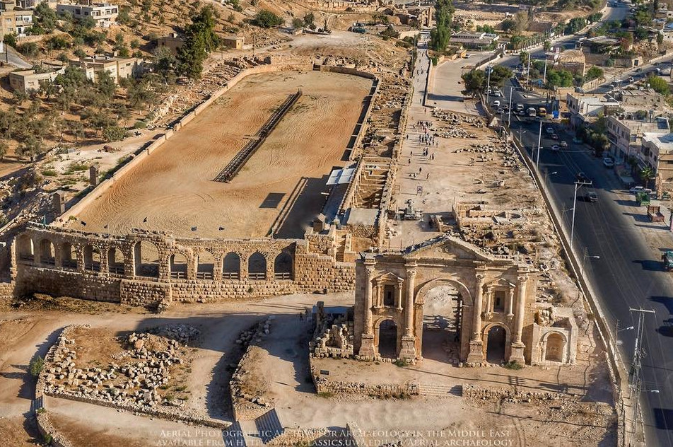 Restored Hippodrome at Jerash with Hadrian's Arch in the front and to the right.
APAAME
- Jerash Hippodrome in Google Earth
 Jerash Hippodrome
click on image to explore this site on a new tab in Google Earth
- General Plan of Jerash
from Wikipedia
- Fig. 22 - Plan of hippodrome
(2nd and 3rd centuries CE) from Ostrasz and Kehrberg-Ostrasz (2020)
 Figure 22
P.1. Ground Plan 1: 1st half of 2nd and 3rd cent., 1st phase: construction and primary use of circus – chariot racing
(A.O.1995)
Ostrasz and Kehrberg-Ostrasz (2020) - Fig. 19 - E-W cross section of
Hippodrome showing potential foundation problems from Ostrasz and Kehrberg-Ostrasz (2020)
 Figure 19
Schematic cross-section of hippodrome (A.O.1992)
JW: Note varying thickness of uncompacted fill which would likely to lead to differential settlement
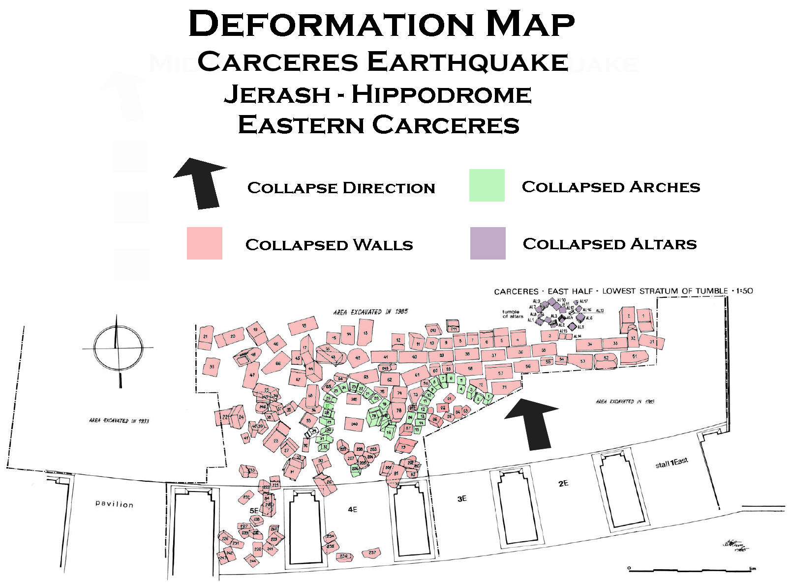
Ostrasz and Kehrberg-Ostrasz (2020) - Fig. 4 - Tumble layer
from mid 8th century earthquake from Ostrasz (1989)
 Fig. 4
Carceres.
East half.
Lowest stratum of tumble
JW: Note uniformity of tumble where collapsed arches appear visible
Ostrasz (1989) - Fig. 21 - Perspective
view of part of carceres from Ostrasz and Kehrberg-Ostrasz (2020)
 Figure 21
Perspective view of part of carceres
(A.O.1992)
Ostrasz and Kehrberg-Ostrasz (2020)

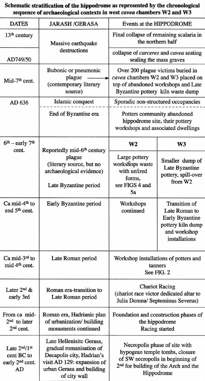 Figure 184
Schematic Chronological chart of the Hippodrome complex showing phases of primary use and secondary occupancies
Ostrasz and Kehrberg-Ostrasz (2020)
- General Plan of Jerash
from Wikipedia
- Fig. 22 - Plan of hippodrome
(2nd and 3rd centuries CE) from Ostrasz and Kehrberg-Ostrasz (2020)
Figure 22
P.1. Ground Plan 1: 1st half of 2nd and 3rd cent., 1st phase: construction and primary use of circus – chariot racing
(A.O.1995)
Ostrasz and Kehrberg-Ostrasz (2020) - Fig. 19 - E-W cross section of
Hippodrome showing potential foundation problems from Ostrasz and Kehrberg-Ostrasz (2020)
Figure 19
Schematic cross-section of hippodrome (A.O.1992)
JW: Note varying thickness of uncompacted fill which would likely to lead to differential settlement
Ostrasz and Kehrberg-Ostrasz (2020)
- General Plan of Jerash
from Wikipedia
- Fig. 4 - Tumble layer
from mid 8th century earthquake from Ostrasz (1989)
Fig. 4
Carceres.
East half.
Lowest stratum of tumble
JW: Note uniformity of tumble where collapsed arches appear visible
Ostrasz (1989)
- General Plan of Jerash
from Wikipedia
- Fig. 4 - Tumble layer
from mid 8th century earthquake from Ostrasz (1989)
Fig. 4
Carceres.
East half.
Lowest stratum of tumble
JW: Note uniformity of tumble where collapsed arches appear visible
Ostrasz (1989)
Ostrasz (1989) found archeoseismic evidence at various parts of the hippodrome which they attributed to a mid 8th century CE earthquake.
The archaeological context of the excavated sections of the cavea was found to be the same almost everywhere. On the outside of the remains of the outer and podium walls, and contiguous to them, was the stone tumble of the upper parts of the walls. The inside of the chambers was filled mainly with the tumble of the stonework of the cavea proper (seat stones and voussoirs of the stepped arches which supported the seating tiers) and with a number of stones of the outer wall. In many chambers the position of the stones displayed clearly that the stonework collapsed during an earthquake. The tumble was subsequently quarried for stone. The quarrying was very extensive; only a small proportion of the stones which made up the particular parts of the masonry was left in the tumble. The parts of the masonry which survived the disaster were also robbed of stones.Ostrasz (1989:137-138) discussed the chronology of destruction.
The stratigraphy of the fill in the chambers was very simple. In most chambers there was only one stratum (from 2 to 4 m thick) over the `floor' level: masonry tumble composed of dressed stones, boulders and rubble, all immersed in earth. 7 The tumble lay directly on the `floor' which in chambers E40-E55 is the unlevelled surface of rock and in all others the top of the fill within the foundation walls of the chambers. The fill itself is another, the lowest stratum. Is is composed of thick layers of earth and thinner and irregular layers of stone chips. In some chambers there was an intervening thin layer of earth and rubble between the top and bottom of the two strata mentioned above. The tumble outside the outer wall lay on top of a residual layer from 0.3 m to 0.8 m thick. Underneath, there is the same kind of earth with which the space within the foundation walls of the chambers (and the arena) is filled. The masonry tumble outside the podium wall lay directly on the surface of the arena 8.
The archaeological context of the carceres was very similar to that of the cavea. On both sides of the remains in situ and contiguous to them, as well as inside the staffs, there was the tumble of the upper parts of the masonry destroyed by an earthquake (fig. 4). Most of the masonry collapsed northwards, on to the arena. The bulk of the tumble was not disturbed by quarrying for stone and every stone retained its tumbled position. The tumble lay on the surface of the arena.
The excavated sections of the hippodrome displayed clearly that the building was finally destroyed by an earthquake. The best attested examples were found in the carceres, in chambers E40-E43 and E25-E28 (currently under excavation), and in the neighbouring church of Bishop Marianos. The coins and the ceramic material from the deposits sealed by the tumble provided evidence for dating the occurrence. No material dating beyond the Umayyad period was found in any of the deposits. The latest coin from the deposit under the tumble of the carceres is datable to the first half of the eighth century and the latest ceramic material found in it dates to the eighth century (Kehrberg 1989: 88). The latest coins recovered from under the tumble in chambers E40, E41, E42 and E43 were minted in 383-395, 498-518, 575/6 and between 527 and 602, respectively. The latest pottery, lamps and lamp fragments from the same deposits date to the seventh century. The only coin found under the tumble of the church of Bishop Marianos was minted in the first half of the eighth century and the objects are dated to the same period (Gawlikowski/Musa 1986: 149-153).
The finds prove that the south-east part of the cavea stood high in the seventh century and the carceres and the church still stood high in the first half of the eighth century. The lack of material dating after the middle of the eighth century shows that this part of the building was either abandoned or destroyed at, and never occupied after, this date. The archaeological context of the finds in the church clinches the matter. It shows that...the church remained in use to its end.(Gawlikowski/Musa 1986: 141), that is until the earthquake which must then have occurred about the middle of the eighth century.
Only one earthquake is securely attested in the region of ancient Palestine in the eighth century and this is the earthquake of 748 (747) (Russell 1985: 39, 47-49). It is also well attested at Jerash (Bitti 1986: 191-192; Crowfoot 1929: 19, 25; id., in Kraeling 1938: 221, 242, 244; Parapetti 1989a: passim; Parapetti 1989b: passim; Rasson/Seigne 1989: 125, 151; Seigne 1986: 247; Seigne 1989: passim). The hippodrome of Gerasa is yet another well attested example of that disaster.
| Effect | Location | Image(s) | Description |
|---|---|---|---|
| Collapsed Walls | SW part of the cavea
Figure 22 P.1. Ground Plan 1: 1st half of 2nd and 3rd cent., 1st phase: construction and primary use of circus – chariot racing (A.O.1995) Ostrasz and Kehrberg-Ostrasz (2020)
Figure 19Schematic cross-section of hippodrome (A.O.1992) JW: Note varying thickness of uncompacted fill which would likely to lead to differential settlement Ostrasz and Kehrberg-Ostrasz (2020) |
|
|
| Collapsed Walls | upper parts of the hippodrome
Figure 22 P.1. Ground Plan 1: 1st half of 2nd and 3rd cent., 1st phase: construction and primary use of circus – chariot racing (A.O.1995) Ostrasz and Kehrberg-Ostrasz (2020)
Figure 19Schematic cross-section of hippodrome (A.O.1992) JW: Note varying thickness of uncompacted fill which would likely to lead to differential settlement Ostrasz and Kehrberg-Ostrasz (2020) |
|
| Effect | Location | Image(s) | Description |
|---|---|---|---|
| Collapsed Walls | most of the hippodrome except for the carceres and the south-east part of the cavea
Figure 22 P.1. Ground Plan 1: 1st half of 2nd and 3rd cent., 1st phase: construction and primary use of circus – chariot racing (A.O.1995) Ostrasz and Kehrberg-Ostrasz (2020)
Figure 19Schematic cross-section of hippodrome (A.O.1992) JW: Note varying thickness of uncompacted fill which would likely to lead to differential settlement Ostrasz and Kehrberg-Ostrasz (2020) |
|
| Effect | Location | Image(s) | Description |
|---|---|---|---|
| Collapsed Walls and arches (in a northward direction) |
eastern half of the carceres (stalls 1E-5E)
Figure 22 P.1. Ground Plan 1: 1st half of 2nd and 3rd cent., 1st phase: construction and primary use of circus – chariot racing (A.O.1995) Ostrasz and Kehrberg-Ostrasz (2020)
Figure 21Perspective view of part of carceres (A.O.1992) Ostrasz and Kehrberg-Ostrasz (2020) |
Fig. 4 Carceres. East half. Lowest stratum of tumble JW: Note uniformity of tumble where collapsed arches appear visible Ostrasz (1989) |
|
| Collapsed Walls and arches (in a northward direction) |
western half of the carceres (stalls 1W-5W)
Figure 22 P.1. Ground Plan 1: 1st half of 2nd and 3rd cent., 1st phase: construction and primary use of circus – chariot racing (A.O.1995) Ostrasz and Kehrberg-Ostrasz (2020)
Figure 21Perspective view of part of carceres (A.O.1992) Ostrasz and Kehrberg-Ostrasz (2020) |
|
|
|
cavea
Figure 22 P.1. Ground Plan 1: 1st half of 2nd and 3rd cent., 1st phase: construction and primary use of circus – chariot racing (A.O.1995) Ostrasz and Kehrberg-Ostrasz (2020) |
|
| Effect | Location | Image(s) | Description |
|---|---|---|---|
| Arch damage | Beneath the cavea
Figure 22 P.1. Ground Plan 1: 1st half of 2nd and 3rd cent., 1st phase: construction and primary use of circus – chariot racing (A.O.1995) Ostrasz and Kehrberg-Ostrasz (2020)
Figure 19Schematic cross-section of hippodrome (A.O.1992) JW: Note varying thickness of uncompacted fill which would likely to lead to differential settlement Ostrasz and Kehrberg-Ostrasz (2020) |
 Plate XIVb
Hippodrome Two arch rings beneath the cavea.Section M. JW: Arch deformation present - possibly earthquake induced Kraeling at al (1938) |
|
| Arch damage | West cavea chambers
Figure 22 P.1. Ground Plan 1: 1st half of 2nd and 3rd cent., 1st phase: construction and primary use of circus – chariot racing (A.O.1995) Ostrasz and Kehrberg-Ostrasz (2020)
Figure 19Schematic cross-section of hippodrome (A.O.1992) JW: Note varying thickness of uncompacted fill which would likely to lead to differential settlement Ostrasz and Kehrberg-Ostrasz (2020) |
 Fig. 33 P.7
Late Roman tannery and pottery workshops installations in west cavea chambers of the hippodrome (photos Nov. 1996) JW: Note arch damage Ostrasz and Kehrberg-Ostrasz (2020) |
|
- Modified by JW from Fig. 4 of Ostrasz (1989)
 Deformation Map
Click on image to open in a new tab
Modified by JW from Fig. 4 of Ostrasz (1989)
-
Earthquake Archeological Effects chart
of Rodríguez-Pascua et al (2013: 221-224)
 Earthquake Archeological Effects (EAE)
Rodríguez-Pascua et al (2013: 221-224)
| Effect | Location | Image(s) | Description | Intensity |
|---|---|---|---|---|
| Collapsed Walls | SW part of the cavea
Figure 22 P.1. Ground Plan 1: 1st half of 2nd and 3rd cent., 1st phase: construction and primary use of circus – chariot racing (A.O.1995) Ostrasz and Kehrberg-Ostrasz (2020)
Figure 19Schematic cross-section of hippodrome (A.O.1992) JW: Note varying thickness of uncompacted fill which would likely to lead to differential settlement Ostrasz and Kehrberg-Ostrasz (2020) |
|
VIII + | |
| Collapsed Walls | upper parts of the hippodrome
Figure 22 P.1. Ground Plan 1: 1st half of 2nd and 3rd cent., 1st phase: construction and primary use of circus – chariot racing (A.O.1995) Ostrasz and Kehrberg-Ostrasz (2020)
Figure 19Schematic cross-section of hippodrome (A.O.1992) JW: Note varying thickness of uncompacted fill which would likely to lead to differential settlement Ostrasz and Kehrberg-Ostrasz (2020) |
|
VIII + |
-
Earthquake Archeological Effects chart
of Rodríguez-Pascua et al (2013: 221-224)
Earthquake Archeological Effects (EAE)
Rodríguez-Pascua et al (2013: 221-224)
| Effect | Location | Image(s) | Description | Intensity |
|---|---|---|---|---|
| Collapsed Walls | most of the hippodrome except for the carceres and the south-east part of the cavea
Figure 22 P.1. Ground Plan 1: 1st half of 2nd and 3rd cent., 1st phase: construction and primary use of circus – chariot racing (A.O.1995) Ostrasz and Kehrberg-Ostrasz (2020)
Figure 19Schematic cross-section of hippodrome (A.O.1992) JW: Note varying thickness of uncompacted fill which would likely to lead to differential settlement Ostrasz and Kehrberg-Ostrasz (2020) |
|
VIII + |
-
Earthquake Archeological Effects chart
of Rodríguez-Pascua et al (2013: 221-224).
Earthquake Archeological Effects (EAE)
Rodríguez-Pascua et al (2013: 221-224)
| Effect | Location | Image(s) | Description | Intensity |
|---|---|---|---|---|
| Collapsed Walls and arches (in a northward direction) |
eastern half of the carceres (stalls 1E-5E)
Figure 22 P.1. Ground Plan 1: 1st half of 2nd and 3rd cent., 1st phase: construction and primary use of circus – chariot racing (A.O.1995) Ostrasz and Kehrberg-Ostrasz (2020)
Figure 21Perspective view of part of carceres (A.O.1992) Ostrasz and Kehrberg-Ostrasz (2020) |
Fig. 4 Carceres. East half. Lowest stratum of tumble JW: Note uniformity of tumble where collapsed arches appear visible Ostrasz (1989) |
|
VIII + |
| Collapsed Walls and arches (in a northward direction) |
western half of the carceres (stalls 1W-5W)
Figure 22 P.1. Ground Plan 1: 1st half of 2nd and 3rd cent., 1st phase: construction and primary use of circus – chariot racing (A.O.1995) Ostrasz and Kehrberg-Ostrasz (2020)
Figure 21Perspective view of part of carceres (A.O.1992) Ostrasz and Kehrberg-Ostrasz (2020) |
|
VIII + | |
|
cavea
Figure 22 P.1. Ground Plan 1: 1st half of 2nd and 3rd cent., 1st phase: construction and primary use of circus – chariot racing (A.O.1995) Ostrasz and Kehrberg-Ostrasz (2020) |
|
|